The Confederated Tribes of the Coos, Lower Umpqua and Siuslaw Indians. Long Range Transportation Plan May 2010
|
|
|
- Alicia Morris
- 5 years ago
- Views:
Transcription
1
2
3


4 The Confederated Tribes of the Coos, Lower Umpqua and Siuslaw Indians Long Range Transportation Plan May 2010 The Confederated Tribes of the Coos, Lower Umpqua and Siuslaw Indians 1245 Fulton Ave. Coos Bay, Oregon 97420
5 The Confederated Tribes of Coos, Lower Umpqua and Siuslaw Indians Tribal Council: Warren Brainard...Chief Bob Garcia, Chair....Position No. 1 Beaver Bowen...Position No. 2 Mark Ingersoll, Vice-Chair...Position No. 3 Ron Brainard...Position No. 4 Wendy Williford...Position No. 5 Aaron McNutt. Position No. 6 The Confederated Tribes of Coos, Lower Umpqua and Siuslaw Indians Project Staff: Howard Crombie...Director of Natural Resources Jeff Stump.. GIS Specialist ii
6 Table of Contents Tribal History... 1 Tribal Enrollment... 2 Table 1: Location of Tribal Membership... 2 Transportation Infrastructure and Land Use... 2 Highway Florence... 3 Figure 1 Florence Area... 3 Figure 2 Confederated Tribes Three Rivers Casino... 4 Highway The Siuslaw River... 5 Figure 3 Siuslaw River Bridge... 6 The Bay Area... 6 The Oregon International Port of Coos Bay... 6 Figure 4 Charleston Marina and the Oregon Dunes... 7 Figure 5 McCullough Bridge... 8 Southwest Oregon Regional Airport... 8 Cape Arago Highway... 9 Other Infrastructure... 9 Figure 6 - Umpqua River Bridge... 9 Transportation Planning Indian Reservation Roads (IRR) Program Transportation Goals Recommendations Short Term ( ) Mid Term ( ) Long Term ( ) Miscellaneous Recommendations: Appendix A Maps Appendix B Sources Appendix C Inventory Detail iii
7 Tribal History In 1855, a treaty was drafted by the federal government to allow for the peaceful acquisition and settlement of the Confederated Tribes of Coos, Lower Umpqua and Siuslaw Indians (Confederated Tribes) ancestral lands. Being promised compensation for the loss of their homelands and concerned for the continued safety of their members, the three Tribes agreed to the Treaty of 1855, trusting the United States to make good on its commitment. It was the draft 1855 treaty and activities around it that linked the three Tribes together although they had been closely associated for centuries prior. In 1916, the Tribes established a formal, elected tribal government which they have continuously maintained. Belatedly, in February of 1941, the Bureau of Indian Affairs took a small parcel (6.12 acres) into trust for the Confederated Tribes in the Empire District of Coos Bay, Oregon. This privately donated reservation is the site of the Tribal Hall and served throughout the Termination years ( ) as a small, but significant symbol of unity for tribal members. The Confederated Tribes unanimously voted to strongly oppose termination. However, they were included, without their knowledge or consent, in the Western Oregon Termination Act of To quote, The blatant lack of participation in the process is most evident among the Indians of Southwest Oregon. The Coos, Lower Umpqua and Siuslaw never passed a resolution in favor of termination, and were adamantly opposed [to it]. In 1948, the Coos, Lower Umpquas [sic] sent forty-eight delegates to the Siletz Reservation to express their disapproval of termination; but were not allowed to make their case, as they had been locked out of the meeting and [were] told the termination bill did not affect them. The Confederated Tribes refused to accede to the sale of their land and Tribal Hall, and maintained the acreage in ambiguous status until Restoration in The Termination Act of 1954 proved disastrous to the Confederated Tribes. Having lost all of their resources to the federal government without the agreed upon compensation, what little federal assistance they were receiving was terminated as a result of the Act. During the period between 1955 and 1984, the Confederated Tribes had to rely on what little resources they could muster in an attempt to provide services to members. Supplying even the most basic services to tribal members was nearly impossible. The tribal government, although terminated from federal relations, never disbanded and continued to press forward and plan for the future. On October 17, 1984, President Ronald Reagan restored the Tribes to federal recognition by signing Public Law and reaffirming the Tribes status as a sovereign nation. Along with this recognition came very basic programs to provide once again the most essential services and lay a preliminary foundation for future program growth. 1
8 Tribal Enrollment The information in Table 1 was obtained from Tribal enrollment records and is current as of June Tribal enrollment has increased nearly one-third since Membership within Oregon grew by 107 new members while membership in other states grew by 135 members. 61.9% of Tribal members live in Oregon, 44.9% in the 5-county Service Area of Lincoln, Lane, Coos, Curry and Douglas counties. Table 1: Location of Tribal Membership Location Growth Number Percent Number Percent Number Percent OREGON % % % 5-County Service Area % % % Coos % % % Curry 5 3% 5 0.5% 0 0% Douglas 25 4% % 9 36% Lane % % % Lincoln 21 3% % % Other OR Counties % % % Other States % % % Canada Unknown 31 4% % % Total Membership % Transportation Infrastructure and Land Use An important relationship exists between land use and transportation infrastructure. Changes in land use create varying demands upon the existing transportation system and transportation systems influence how land is utilized. The Confederated Tribes transportation system is defined by their Ancestral Territory along the Pacific Ocean on the rugged Oregon Coast. Their small and scattered land holdings are barely a fraction of the 1.6 million acre homeland that stretched for seventy miles north and south along the Pacific Ocean and 50 miles inland to the Coast Range of Mountains. The four major cities within the ancestral territory are Florence, Reedsport, North Bend and Coos Bay, Oregon. The Bay Area (Coos Bay, North Bend and Charleston) and Florence are the two main Tribal population centers in the Ancestral Territory. Coos Bay, North Bend and Florence are the largest cities by population, respectively, in the Ancestral Territory. The Ancestral Territory includes parts of 3 counties: Lane, Coos and Douglas. These cities are also traditional centers of Tribal activity. The cities each lie on a water body named for a Tribe Florence is on the Siuslaw River, Reedsport is on the Umpqua River and Coos 2


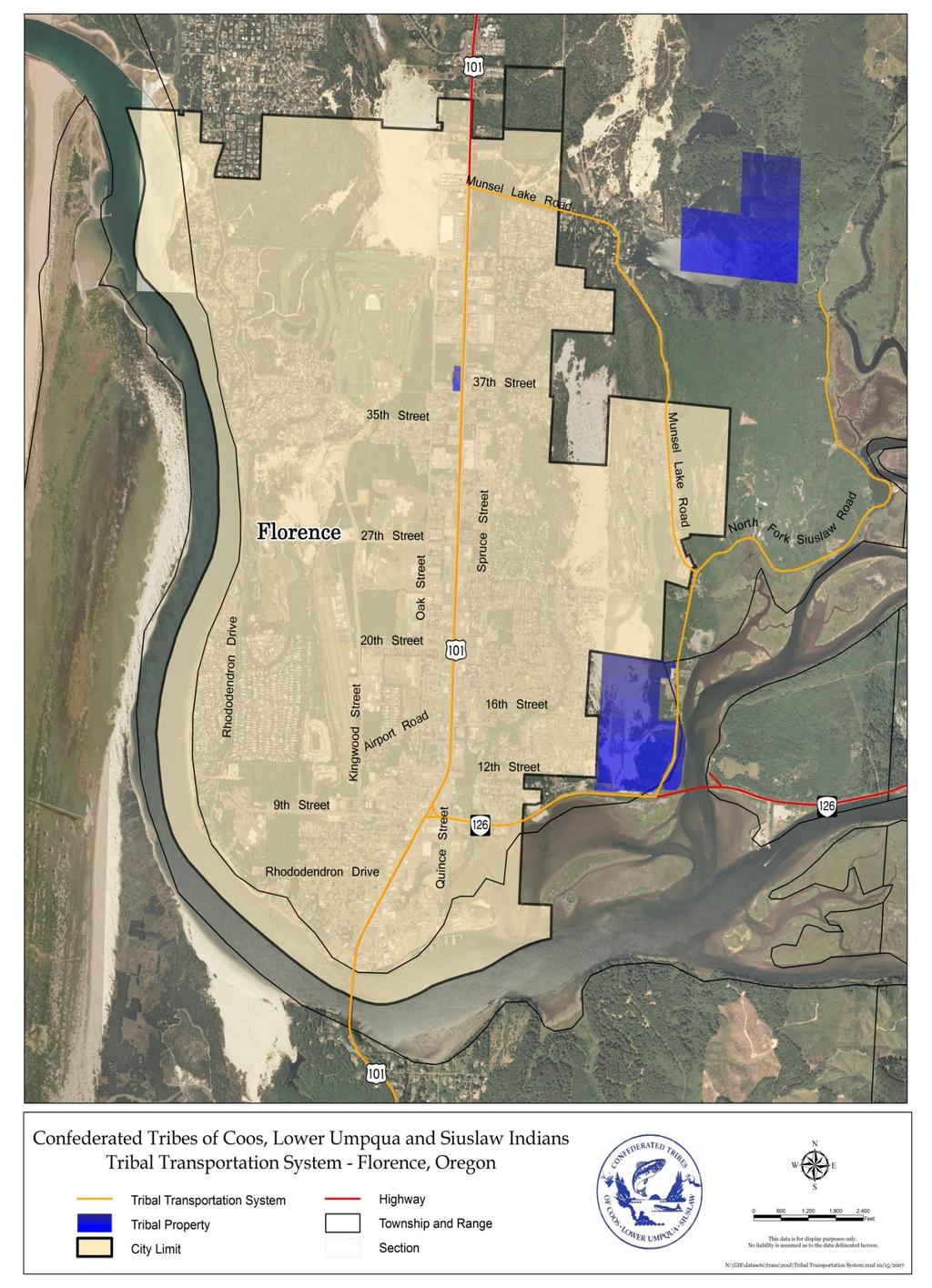
9 Bay/North Bend is on Coos Bay near Coos River. Outside the Ancestral Territory, a significant number of Tribal members live in the Eugene-Springfield Area. Highway 101 The Oregon Coast Highway, Highway 101, is the primary route connecting these coastal cities together. This highway is a principal arterial and a State Highway on the National Highway System (NHS) that runs the entire length of the Oregon Coast through most coastal cities from the Washington State line to the California State line. The Pacific Coast Scenic Byway, as it is also known, was recognized in 1991 as Oregon s first State Scenic Byway and in 1998 it was dedicated as a National Scenic Byway. An interesting tour of the Oregon Coast Highway can be found online at The 48 mile segment of Highway 101 between Florence and the Bay Area is the most important route in terms of providing access to employment, services, recreation and cultural resources for the Confederated Tribes. This stretch of highway provides access to the Confederated Tribes Three Rivers Casino, the Siuslaw National Forest and the Oregon Dunes National Recreation Area. It provides access to the Pacific Ocean as well as over a dozen lakes, campgrounds and trails, as well as traditional hunting, gathering and fishing sites. Some of the more significant lakes along this route include Woahink, Siltcoos, Tahkenitch, Eel, Munsel and the Tenmile lakes. Florence Florence is a nationally recognized retirement community. The city s unique natural Oregon landscape and many nearby attractions help make it a tourist destination. Tourist attractions include the Heceta Head lighthouse and Sea Lion Caves, Three Rivers Casino, Old Town Florence and the port on the Siuslaw River. Figure 1 Florence Area 3


10 Florence is located in Lane County Oregon. Per the 2000 census it has a population of 7,453 with 48.9% of the population 60 years of age and over. The unemployment rate in Florence is 10.6% and over 75% of employees work in the service and retail sectors also according to the 2000 census. The major employers in Florence are the Confederated Tribes Three Rivers Casino and Peace Health who each employee an estimated 475. The Confederated Tribe s newly constructed Three Rivers Casino near Florence is a key tourist destination in Florence and serves as a major employer for the Confederated Tribes and the local community. The Casino continues to grow and benefits from its location adjacent to the city limits of Florence near the intersection of Highway 126 and Highway 101. These routes provide crucial links to the market in Eugene-Springfield and to the general tourist trade. Due to the Casino s importance to Tribal self-determination, further improvements to the transportation infrastructure in and around the facility are being developed. The Severy Access project is being developed to provide access to the northern portion of the Casino parcel also referred to as the Hatch Tract. Dependent upon the design, the project could also provide a much needed east-west link from the City of Florence to Lane County s North Fork Siuslaw Road east of the Three Rivers Casino. The Hatch Tract is the Confederated Tribes single largest parcel of trust land. Figure 2 Confederated Tribes Three Rivers Casino 4
11 Highway 126 Highway 126 is another key component of the transportation infrastructure providing access for Tribal Members, tourists and citizens to and from the community of Florence. Highway 126 is a state highway (OR 126) also on the National Highway System. This route is the primary east-west route in Florence. It starts in Florence at Highway 101 at milepost and travels east, past the entrance to the Three Rivers Casino, to Eugene and Interstate 5 and continues over the Cascade Mountains to Eastern Oregon. This route is heavily traveled by tourists and weekenders traveling west from the inland valleys and Eastern Oregon to the Pacific Ocean, the Oregon Dunes, Siuslaw National Forest and the many other attractions along Highway 101. Critical to the operation of Highway 126 is the North Fork Siuslaw River Bridge. The bridge is currently being replaced and the new bridge is being constructed just south of the current bridge at milepost 1.17 just east of the City of Florence and the entrance to the Three Rivers Casino. Also planned are improvements to North Fork road adjacent to the bridge. North Fork Road provides secondary access to the casino and also provides access to the Tribes Munsel Lake property. It is anticipated to take 4 years to complete the project due to environmental issues associated with its location adjacent to the Siuslaw and North Fork Siuslaw rivers and their wetlands. The construction contract was awarded in September 2007 for $14,482, The Siuslaw River The Siuslaw River itself is also an important transportation infrastructure element for the Confederated Tribes as well as the community of Florence. Florence was almost entirely dependent on its natural resource economy mainly fishing and timber throughout the first half of the 20 th century and the Siuslaw Indians have been dependent for untold generations upon this river for subsistence as well as transportation. The Port of Siuslaw is located on the Siuslaw River and is considered a critical harbor of refuge. The Port is home to a United States Coast Guard (USCG) station and, according to the U.S. Army Corps of Engineers (USACE), its bar had 1,351 commercial crossings in The USACE also reported the economic impact of the Port of Siuslaw to the community in 2005 as $12.5 million. In Florence, 5 miles up the Siuslaw River, the port manages various facilities including a marina which has commercial docks, a waterfront boardwalk and a recreational marina. Adjacent to the marina, the port also operates an RV park and campground which accommodates the many fishermen who come to fish on the river, the ocean or the local lakes. Crabbing, clamming, beachcombing and kayaking are also activities you ll find within the Siuslaw River watershed and its water trails. Milepost 191 on Highway 101 is the southern city limits of Florence and where the Siuslaw River Bridge begins. This bridge is eligible for the National Register of Historic Places and is a steel double-leaf bascule drawspan. The historic bridges along Highway 101 between the Bay Area and Florence are key transportation infrastructure elements to the Confederated Tribes. 5


12 Figure 3 Siuslaw River Bridge The Bay Area The Tribes other main population center is the Bay Area which includes the adjacent cities of Coos Bay and North Bend. Another community, Charleston, is also part of the Bay Area but is at the entrance to Coos Bay and is unincorporated and under the jurisdiction of Coos County. The Bay Area is the largest metropolitan area in Coos County, on the Oregon Coast and in the Tribes Ancestral Territory. Coos Bay has a population of 15,484 and North Bend has a population of 9,683 according to the 2000 census. Charleston is home to the Oregon Institute of Marine Biology, South Slough National Estuarine Research Reserve and US Coast Guard (USCG) Life Boat Station. The Charleston Marina Complex provides moorage for about 550 boats and is owned and operated by the Oregon International Port of Coos Bay. Coos County s economy, historically, was dependent upon its substantial natural resources, primarily, timber, fish and coal. Sawmills, canneries and mines sprung up and ships were built to transport their products out through the Port of Coos Bay. However today, these resources are diminished and the industries associated with them are no longer as dominant a part of the economy as they once were. The economy continues to transition and now is also dependent upon other sectors such as health care, retail trade and the service industry including tourism. The Oregon International Port of Coos Bay The Oregon International Port of Coos Bay does, however, continue to influence the Bay Area economy. Coos Bay is one of the largest coastal deep draft ports on the west coast - behind only San Francisco and Seattle. Per the US Army Corps of Engineers (USACE), 2.3 million tons of cargo (mainly wood products) valued at $25.1 million travels through the port annually which included 26 million pounds of fish and shellfish landings in The USACE maintains the Coos Bay and Siuslaw River jetties and channel including the boat basin access channel at Charleston. 6
 in September 2007 due to safety concerns.")

13 The Oregon International Port of Coos Bay is also involved in development projects which stand to significantly impact economic development in the region. The Port agreed in December 2008 to purchase and operate approximately 94 miles of rail line abandoned by the Central Oregon & Pacific Railroad (CORP) in September 2007 due to safety concerns. The Port has agreed to pay the 16.6 million dollars for the rail line. It is anticipated the Port will then proceed to repair the line and sub-contract with a short-line rail operator to run the railroad. Another big project the Port is involved with is the proposed deep-water Liquefied Natural Gas (LNG) terminal at Coos Bay. The Jordan Cove Energy Project as it is called is in the planning stage and would require State and Federal Energy Regulatory Commission (FERC) permitting and approval. The project involves the construction and operation of an LNG terminal on Coos Bay which would receive the LNG via ships, store it and subsequently deliver it via pipelines. Figure 4 Charleston Marina and the Oregon Dunes 7
14 The McCullough Bridge (Figure 5) is also a key infrastructure component in the Bay Area and stretches out over a mile across the bay from the northern city limits of North Bend. Built in 1936, the Bridge is a landmark and is arguably one of the most, if not the most, significant structures architecturally on the entire Oregon Coast Highway. The 5,305 foot cantilever truss has many architectural and decorative features and has been referred to as the gateway to the Oregon Dunes which begin just north of the bridge. Figure 5 McCullough Bridge Southwest Oregon Regional Airport Another key transportation infrastructure element critical to the area s economy is the Southwest Oregon Regional Airport (SORA) in North Bend. The airport provides critical access to air service for Confederated Tribes members and staff traveling for business. The airport is the Oregon Coast s only commercial airport which provides access to some of the major tourist destinations in Coos County. These destinations include the Bandon Dunes Golf Resort, the Coquille Indian Tribe s Mill Casino and Hotel in Coos Bay and the Charleston Marina near the mouth of Coos Bay. Another draw is the Oregon Dunes National Recreation Area, just north of North Bend, which hosts an annual Dunefest celebration. United Airlines (Skywest Express) provides service from the Southwest Oregon Regional Airport to the San Francisco International and Portland International Airports. Many private jets arrive at the airport too oftentimes carrying golfers destined for the Bandon Dunes Resort. The USCG Air Station and USCG Sector Headquarters are also located at the Southwest Oregon Regional Airport facility. The airport has just completed $31 million dollars in upgrades to the facility including a new terminal. It is estimated that between 60,000 and 70,000 people currently pass through this airport. 8
15 Cape Arago Highway Cape Arago Highway is a key transportation infrastructure element as it is a major east-west and north-south route in the Bay Area. This route provides arterial access to the majority of the Tribe s Bay Area properties. Tribal Members and staff utilize this route regularly for accessing housing at Qaxas Heights, their work at either Tribal Administration or Three Rivers Casino and visiting/working at Baldich (Chiefs Island and Gregory Point) and Coos Head. Cape Arago Highway begins at milepost of Highway 101 and then travels west along Virginia Avenue. It then travels south on Broadway Avenue and west on Newmark Avenue in North Bend. The City of Coos Bay then has jurisdiction of Cape Arago Highway between Cape Arago Highway mileposts 2.24 and The highway returns to State jurisdiction south of the City of Coos Bay and crosses the South Slough at the South Slough Drawbridge at milepost 8.33, another key infrastructure element. Cape Arago Highway south of Coos Bay provides access to Charleston, the Charleston Marina, the Oregon Institute of Marine Biology and South Slough National Estuarine Research Reserve before it travels along the Pacific Ocean. It is the gateway to many of the premiere cultural sites, trails and recreational destinations in Coos County. Bastendorf Beach County Park, Sunset Bay State Park and Shore Acres State Park are all located along Cape Arago Highway and the highway ends at Cape Arago State Park at milepost Gregory Point, also located along Cape Arago Highway, is especially significant as it is one of the critical few remaining Tribal cultural sites in Coos County. Coos Head, also located along Cape Arago Highway, is being developed into an economic resource to diversify the tribal economy. Other Infrastructure Another key transportation infrastructure element of Highway 101 is the Umpqua River Bridge (figure 6) which was also built in 1936 by Conde McCullough. It is located at milepost at the northern city limits of Reedsport. Highway 101 is critical for the Confederated Tribes goal of economic self sufficiency as tourists regularly travel this scenic route along the Pacific Ocean, and as tribal members and staff travel between administrative and economic centers in Coos Bay and Florence. Figure 6 - Umpqua River Bridge 9
16 Transportation Planning The purpose of long-range transportation planning is to clearly demonstrate a tribe s transportation needs and to fulfill tribal goals by developing strategies to meet these needs. These strategies should address future land use, economic development, traffic demand, public safety, and health and social needs. The time horizon for long-range transportation planning should be 20 years to match state transportation planning horizons. Indian Reservation Roads (IRR) Program The bulk of the federal funding received to develop the Confederated Tribes transportation infrastructure comes from the Indian Reservation Roads (IRR) program. The IRR program funding is provided in the surface transportation act. The current act is the Safe, Accountable, Flexible, Efficient, Transportation Equity Act: A Legacy for Users (SAFETEA-LU) and is authorized for 5 years (FFYs ). The IRR program is jointly administered through a Memorandum of Agreement between the Federal Highway Administration s (FHWA) Federal Lands Highway Program (FLHP) and the Bureau of Indian Affairs. The IRR Program Regulations are found in the Federal Register, 25 C.F.R. 170 (Final Rule of July 19, 2004), which provides the framework for participation in the IRR Program. The Confederated Tribes receive a Tribal Share of construction funding through their participation in the IRR program. The Tribal Share is determined, in big part, by the Relative Need Distribution Formula (RNDF) which utilizes the Road Inventory Field Data System (RIFDS) database to evaluate a tribe s needs. The RIFDS road inventory database is updated annually and the Long Range Transportation Plan (LRTP) and Tribal Transportation Improvement Program (TTIP) documents are required attachments. A TTIP is a financially constrained prioritized list of the Tribes projects needing funding and along with Long Range Transportation Plans and Priority Lists are adopted through formal Tribal Government action. The BIA Area Offices collect and combine the TTIPs into Control Schedules which are then developed into an Indian Reservation Road Transportation Improvement Program (IRR TIP) by the BIA Division of Transportation for each State where Indian reservation roads exist. An approved IRR TIP included in the State Transportation Improvement Program (STIP) is the official document which authorizes obligation of Highway Trust Funds for IRR construction projects. Activities eligible for transportation planning funding under the IRR Program include, but are not limited to, the following: Planning activities for other modes of transportation such as mass transit, air, etc., and intermodal connections. Development of rural addressing and street maps. Researching right-of-way records for transportation planning purposes. Indian Reservations Roads (IRR) road inventory and/or bridge inventory Measurement of traffic Analysis of transportation need based on current and proposed land use 10
17 Trip generation studies Calculation of road/intersection capacities Development and use of management systems Development/updating of Tribal long-term transportation plans Project priority analysis Development/updating of Transportation Improvement Programs (TIP) Special transportation studies: Bicycle paths Pedestrian walkways Access to other facilities (i.e., airports, waterways, rail stations, bus terminals, regional refuse station, recreational facilities) Scenic area pullouts, rest areas, and parking. Transit planning Development of maintenance maps Bureau of Indian Affairs functional classification of roads Transportation Goals A safe and efficient Tribal transportation system responsive to the needs of the Tribe and community. A Tribal transportation system that supports and fosters economic development. A Tribal Transportation program that provides for increased opportunities for Tribal Members. An expanded Tribal Government capacity to plan, develop and manage transportation systems and facilities. Recommendations The first recommendation is to continue to conduct the annual transportation planning performed through the Confederated Tribes P.L contract with the Bureau of Indian Affairs. The Confederated Tribe should continue to support those transportation planning functions performed in-house which facilitate the further development of the Confederated Tribes projects and the development of the funding sources needed to complete them. These functions include: update and review of the Long Range Transportation Plan development of the Tribal Transportation Improvement Program update to the Tribal transportation inventory database The following short, mid and long term recommendations are a product of these planning processes. They underscore the Confederated Tribes transportation planning capacity and the importance of this planning. 11
18 Short Term ( ) (1) Location: Tribal Hall Trail Tribal Hall Description: Grading, drainage, addition of gravel surface and/or bituminous overlay Length: 0.20 miles Reason: Trail, improved access to Tribal Village and parking Project Type: Trail Improvement Estimated Cost: $480,000 (2) Location: Main Base Road Coos Head Description: Reconstruction Length: 0.35 miles Reason: Upgrade route providing access to the Confederated Tribes planned administrative facilities at Coos Head. Project Type: Road Improvement Estimated Cost: $750,000 (3) Location: Severy Access Hatch and Severy Tract Description: Grading, drainage, addition of gravel surface and bituminous overlay Length: 0.5 miles Reason: Access route to planned residential properties on the Hatch and Severy Tracts Project Type: New Construction Estimated Cost: $1,200,000 Mid Term ( ) (4) Location: Munsel Lake Access Munsel Lake Property Description: New road construction Length: 0.50 miles Reason: Road will provide access to the Confederated Tribes pristine Munsel Lake property which currently is only accessible by boat Project Type: New construction Estimated Cost: TBD (5) Location: Neese Street Tribal Hall Description: Redesign Length: 0.20 miles Reason: City of Coos Bay owned gravel road adjacent to Tribal Hall requires import, grading and paving Project Type: Redesign Estimated Cost: TBD (6) Location: Base Access Coos Head Description: New road construction Length: 0.50 miles Reason: Road will provide access to the Confederated Tribes development Project Type: New construction Estimated Cost: TBD 12
19 (7) Location: Highway 126 Three Rivers Casino Description: Traffic Signal at intersection with Casino South Length: 0.10 miles Reason: A traffic signal will be needed to accommodate anticipated increase in traffic on route providing access to Three Rivers Casino Project Type: Road improvement Estimated Cost: TBD (8) Location: Radar Road Administration Building Description: Traffic signal at Ocean Boulevard and Radar Road Length: 0.20 miles Reason: Road provides access to administration building and current design presents safety concerns Project Type: Road improvement Estimated Cost: TBD Long Term ( ) (9) Location: Cape Arago Highway Coos Head and Gregory Point Description: Road widening and improvement from South Slough Bridge to Cape Arago Length: 5.6 miles Reason: Road will provide access to Tribal cultural, governmental and recreational activities Project Type: Road Improvement Estimated Cost: TBD (10) Location: Highway 126 Florence to Springfield Description: Road widening and improvement for safety and increased capacity Length: 5.6 miles Reason: Narrow road with many curves and few passing lands poses safety concerns, increases travel time between Florence and Eugene-Springfield deterring travel. Project Type: Road Improvement Estimated Cost: TBD Miscellaneous Recommendations: (11) The expansion of the Confederated Tribes reservation land and the redesignation of a portion of federal forest land as Indian Trust Land will result in a significant increase in the Confederated Tribes inventory of Indian Reservation Roads. A significant increase in inventory of Indian Reservation Roads will require an equally significant effort to evaluate the condition of the roads and incorporate them into the transportation plan. (12) Currently, a significant amount of the Confederated Tribes Indian Reservation Road Inventory consists of non-bia roads. Continue to develop cooperative relationships at the state, county and local levels. Educate partners on the IRR system and how it benefits the entire community. Address their concerns and as appropriate incorporate their recommendations or projects into the Tribal Transportation Plan. 13

20 Appendix A Maps 14

21 15
22 16
23 Appendix B Sources This document is derived from original research and review of existing literature and information. The research included infield on-site visits for IRR inventory data collection. Source materials for the review of existing documents included: 1. Confederated Tribes of Coos, Lower Umpqua and Siuslaw Indian Reservation Roads inventory. 2. Confederated Tribes of Coos, Lower Umpqua and Siuslaw Indian Reservation Transportation Plan 1993 and updated plan Preliminary Draft Bureau of Indian Affairs Portland Area Office roadway construction Control Schedule 2008 and Radar Hill Land Purchase for housing (completed September 8, 1999) environmental assessment. Also known as the Elks property purchase. 5. Coos Bay 2004 Draft Transportation Plan 6. Coos County Transportation Plan (September 1999) 7. Confederated Tribes of Coos, Lower Umpqua and Siuslaw Indians Reservation Plan and Forest Land Restoration Proposal (Revised June 2002). 8. A variety of other local government publications. 17
24 Appendix C Inventory Detail Route Name Route # Section # Need Owner Length (miles) Description/Milepost #/Status Casino South Official Casino East Official Casino North AKA Severy Access/Official Casino West Official Highway M.P to /New Highway M.P to 188.2/New Highway M.P to /New Highway M.P to /New Highway M.P to /New Highway M.P to /New Highway M.P to /New Highway M.P to /New Highway M.P to /New Highway M.P to /New Highway M.P to /New Highway M.P to /New Highway M.P to /New Highway M.P to /New Highway M.P to /New Highway M.P to /New Highway M.P to /New Highway M.P to /New Highway M.P to /New Highway M.P to /New Highway M.P to /New Highway M.P to /New Highway M.P to /New Highway M.P to /New Highway M.P to /New Highway M.P to /New Highway M.P to /New 18
25 Highway M.P to /New Highway M.P to /New Highway M.P to /New Highway M.P to /New Highway M.P to /New Highway M.P to /New Highway M.P to /New Highway M.P to /New Highway M.P to /New Highway M.P to /New Highway M.P to /New Highway M.P to /New Highway M.P to /New Highway M.P to /New Highway M.P to /New Highway M.P to /New Highway M.P to /New Highway M.P to /New Highway M.P to /New Highway M.P to /New Highway M.P to /New Highway M.P to /New Highway M.P to /New Highway M.P to /New Highway M.P to /New Highway M.P to /New Highway M.P to /New Highway M.P to /New Highway M.P to 209.3/New Highway M.P to /New Highway M.P to /New Highway M.P to /New Highway M.P to /New Highway M.P to /New 19
26 Highway M.P to /New Highway M.P to /New Highway M.P to /New Highway M.P to /New Highway M.P to /New Highway M.P to /New Highway M.P to /New Highway M.P to /New Highway M.P to /New Highway M.P to /New Highway M.P to /New Highway M.P to /New Highway M.P to /New Highway M.P to /New Highway M.P to /New Highway M.P to /New Highway M.P to /New Highway M.P to /New Highway M.P to /New Highway M.P to /New Highway M.P to /New Highway M.P to 228.5/New Highway M.P to /New Highway M.P to /New Highway M.P to /New Highway M.P to /New Highway M.P to 232.8/New Highway M.P to /New Highway M.P to /New Highway M.P to /New Highway M.P to /New Highway M.P to /New Highway M.P to /New Highway M.P to /New 20
27 Highway M.P to /New Highway M.P to /New Highway M.P to /New Highway M.P to /New Highway M.P to /New Highway M.P to 237.6/New Highway M.P to /New Highway M.P to /New Highway M.P to /New Ocean Boulevard Official Highway Official Cape Arago Hwy Official Cape Arago Hwy Official Cape Arago Hwy Official Cape Arago Hwy Official Cape Arago Hwy ft Official Cape Arago Hwy Official Cape Arago Hwy Official Newmark Avenue New Newmark Avenue New Newmark Avenue New Empire Boulevard New East Bay Drive Official Kentuck Slough Road Official Sixes River Road Official North Fork Road Official Miluk Village Access Official Radar Road Official Radar Road Official Neese Street Official Wallace Street Official Woolridge Street Official Flanagan Avenue Official Tribal Hall Road Official 21
28 Tribal Hall Trail Official Lakeshore Drive Official Wasson Street Official Virginia Avenue Official Virginia Avenue Official Connecticut Avenue Official Oak Street Official Kusa Avenue Official Admin East Road New Fulton Avenue New Coalbank Lane New N Flanagan Street New Myrtle Avenue New Kingwood Avenue New N 6th Street New Pine Street Official Qaxas Street Official Munsel Lake Road Official Munsel Lake Road Official Munsel Lake Road New Munsel Lake Road New Libby Lane New Southwest Boulevard New Southwest Boulevard New Lockhart Avenue New 4th Street New Johnson Street New Main Base Road Official Coos Head Road New Base Access Road Official Lighthouse Way New Lighthouse Way New Lighthouse Way New Lighthouse Trail New 22
29 Lighthouse Trail New Table field codes Need field code: 0 Transportation facilities which have been improved to their acceptable standard or projects/facilities proposed to receive construction funds on an IRRTIP are not eligible for future inclusion in the calculation of the CTC portion of the formula for a period of 5 years thereafter 1 Existing BIA Roads needing improvements 2 Construction need other than BIA roads needing improvement 3 Substandard or other roads for which no improvements are planned 4 Roads that do not currently exist and need to be constructed, Proposed Roads Ownership field code: 1 BIA including offices in the BIA 2 Tribe 3 State 4 Urban 5 County and Township 7 Other Federal 8 Other 23
Airport Planning Area
 PLANNING AREA POLICIES l AIRPORT Airport Planning Area LOCATION AND CONTEXT The Airport Planning Area ( Airport area ) is a key part of Boise s economy and transportation network; it features a multi-purpose
CHAPTER 4 -- THE LAND USE PLAN: DESCRIPTIONS AND POLICIES FOR THIRTEEN PLANNING AREAS
 CHAPTER 4 -- THE LAND USE PLAN: DESCRIPTIONS AND POLICIES FOR THIRTEEN PLANNING AREAS NORTH CENTRAL CAC AREA LITTLE VALLEY ROAD TO JUG HANDLE CREEK PLANNING AREA This planning area includes Cleone, Noyo,
2016 Regional Transportation Alternatives Program (TAP) Grant Application
 Grant Application") 2016 Regional Transportation Alternatives Program (TAP) Grant Application PROJECT TITLE: Yelm-Tenino Trail Extension Feasibility Study TRPC use only GENERAL PROJECT INFORMATION Agency or Organization City
2016 Regional Transportation Alternatives Program (TAP) Grant Application PROJECT TITLE: Yelm-Tenino Trail Extension Feasibility Study TRPC use only GENERAL PROJECT INFORMATION Agency or Organization City
A CASE FOR COMPLETING THE JORDAN RIVER PARKWAY: A
 A CASE FOR COMPLETING THE JORDAN RIVER PARKWAY: A safe crossing at 9000 South and 850 West Proposed 9000 South Underpass Parkway Timeline Parkway, Trail, and Tourism Facts Blueprint Jordan River 1971 1973
Prepared for Travel Oregon by Kathi Jaworski, Write to Know consulting
 1 2 3 4 5 o 6 7 8 9 Coos County Employment by Industry, 2006-2015 Top Categories of Employment (500+ Jobs) 5,000 4,500 4,000 3,500 3,000 2,500 2,000 1,500 1,000 500 2006 2010 2015 Source: Oregon Employment
4.0 Context for the Crossing Project
 4.0 Context for the Crossing Project This section provides background information about key features of the North Douglas Crossing project area, and opportunities and constraints. This information is important
2. Goals and Policies. The following are the adopted Parks and Trails Goals for Stillwater Township:
 D. PARKS AND TRAILS 1. Introduction Stillwater Township s population is relatively low, with most residents living on rural residences on large lots. The need for active park space has been minimal in
Georgetown-Lewes Rail/Trail Study. Rail/Trail Study: Cool Spring to Cape Henlopen State Park New Road Extension (House Resolution No.
 Georgetown-Lewes Rail/Trail Study Rail/Trail Study: Cool Spring to Cape Henlopen State Park New Road Extension (House Resolution No. 47) August 22, 2011 Presentation Outline Background Benefits Statewide
Westover Metropolitan Airport Master Plan Update
 Westover Metropolitan Airport Master Plan Update June 2008 INTRODUCTION Westover Metropolitan Airport (CEF) comprises the civilian portion of a joint-use facility located in Chicopee, Massachusetts. The
MONTEREY REGIONAL AIRPORT MASTER PLAN TOPICAL QUESTIONS FROM THE PLANNING ADVISORY COMMITTEE AND TOPICAL RESPONSES
 MONTEREY REGIONAL AIRPORT MASTER PLAN TOPICAL QUESTIONS FROM THE PLANNING ADVISORY COMMITTEE AND TOPICAL RESPONSES Recurring topics emerged in some of the comments and questions raised by members of the
Clackamas County Development Agency
 Clackamas County Development Agency Development Services Building, 150 Beavercreek Rd., Oregon City, OR 97045 www.clackamas.us/transportation/renewal 503-742-4323 The Clackamas County Board of Commissioners
Blueways: Rivers, lakes, or streams with public access for recreation that includes fishing, nature observation, and opportunities for boating.
 Parks, Open Space and Trails PRINCE WILLIAM COUNTY 2008 COMPREHENSIVE PLAN TRAILS PLAN CONTENTS The components of the trails plan are: Intent Definitions Goals, Policies, and Action Strategies Trails Map
Non-Motorized Transportation
 Non-Motorized Transportation Non-motorized facilities are important components to the transportation system. They provide an environmentally-friendly, low-cost mode of travel. Some of the facilities can
Project Summary 2009
 Project Summary 2009 SB-2009-MN-55360: Lady Slipper Scenic Byway Pedestrian Walkway State Submission Date not submitted Division Submission Date not submitted State Priority 0 This application must be
FINAL TESTIMONY 1 COMMITTEE ON RESOURCES UNITED STATES HOUSE OF REPRESENTATIVES. July 13, 2005 CONCERNING. Motorized Recreational Use of Federal Lands
 FINAL TESTIMONY 1 STATEMENT OF DALE BOSWORTH CHIEF Of the FOREST SERVICE UNITED STATES DEPARTMENT OF AGRICULTURE Before the SUBCOMMITTEE ON FORESTS AND FOREST HEALTH And the SUBCOMMITTEE ON NATIONAL PARKS,
Chapter 1 Introduction and Project Overview
 Chapter 1 Introduction and Project Overview Kittitas County in cooperation with the Federal Aviation Administration (FAA) is updating the Airport Master Plan for Bowers Field Airport (FAA airport identifier
2008 DEKALB COUNTY TRANSPORTATION PLAN (UPDATE)
") 2008 DEKALB COUNTY TRANSPORTATION PLAN (UPDATE) TABLE OF CONTENTS Introduction 1 Transportation Planning Activities 2 Identification of Problem Areas and Recommended Solutions 7 DeKalb County Projects
2008 DEKALB COUNTY TRANSPORTATION PLAN (UPDATE) TABLE OF CONTENTS Introduction 1 Transportation Planning Activities 2 Identification of Problem Areas and Recommended Solutions 7 DeKalb County Projects
MONTEREY COUNTY TRAVEL IMPACTS P
 MONTEREY COUNTY TRAVEL IMPACTS 1992-2015P April 2016 Prepared for the Monterey County Convention and Visitors Bureau MONTEREY COUNTY TRAVEL IMPACTS, 1992-2015P Prepared for the Monterey County Convention
13.1 REGIONAL TOURISM ISSUES AND SUMMARY OF FINDINGS
 13 REGIONAL TOURISM T he County of Mariposa s recreation needs and facilities fall within two categories: regional tourism and local recreation. This Element focuses on regional tourism issues related
Business Item No XXX. Proposed Action That the Metropolitan Council approve the Coon Creek Regional Trail Master Plan.
 Business Item No. 2015-XXX Metropolitan Parks and Open Space Commission Meeting date: July 7, 2015 For the Community Development Committee meeting of July 20, 2015 For the Metropolitan Council meeting
CHAPTER 5. Chapter 5 Recreation Element
 CHAPTER 5 Recreation Element Chapter 5 Recreation Element The Recreation Element of the Meyers Area Plan is a supplement to the Recreation Element of the TRPA Regional Plan and the El Dorado County General
1.2 Corridor History and Current Characteristics
 SECTION 1 Description and Background of Study Area 1.1 Introduction This preliminary engineering report was prepared for the Alaska Department of Transportation and Public Facilities (ADOT&PF). It is part
Committee Report. Community Development Committee For the Metropolitan Council meeting of April 13, Business Item No.
 Committee Report Business Item No. 2016-48 Community Development Committee For the Metropolitan Council meeting of April 13, 2016 Subject: Harriet Island-South St. Paul Regional Trail Master Plan, Saint
Appendix L Technical Memorandum Aesthetics
 Technical Memorandum Aesthetics 1.0 AESTHETICS This section provides a discussion of the aesthetic resources in the vicinity of ARTIC. Aesthetics pertain to the elements that make a certain view pleasing
University Region Non-Motorized Plan 2015
 Non-Motorized Transportation Non-motorized facilities are important components to the transportation system. They provide an environmentally-friendly, low-cost mode of travel. Some of the facilities can
HARBOR INFRASTRUCTURE INVENTORIES Buffalo Harbor, New York
 HARBOR INFRASTRUCTURE INVENTORIES Buffalo Harbor, New York Harbor Location: Buffalo Harbor is located on the Eastern shore of Lake Erie in the City of Buffalo, NY. Authority: River & Harbor Acts of 1826,
April 10, Mark Stiles San Juan Public Lands Center Manager 15 Burnett Court Durango, CO Dear Mark,
 Mark Stiles San Juan Public Lands Center Manager 15 Burnett Court Durango, CO 81301 Dear Mark, We are pleased to offer the following comments on the draft San Juan Public Lands Center management plans
AGENDA ITEM 5 D WAKULLA ENVIRONMENTAL INSTITUTE (WEI) TRAIL FEASIBILITY STUDY
 TRAIL FEASIBILITY STUDY") March 19, 2018 AGENDA ITEM 5 D WAKULLA ENVIRONMENTAL INSTITUTE (WEI) TRAIL FEASIBILITY STUDY TYPE OF ITEM: Action STATEMENT OF ISSUE The Wakulla Environmental Institute (WEI) Trail is one of several trails
March 19, 2018 AGENDA ITEM 5 D WAKULLA ENVIRONMENTAL INSTITUTE (WEI) TRAIL FEASIBILITY STUDY TYPE OF ITEM: Action STATEMENT OF ISSUE The Wakulla Environmental Institute (WEI) Trail is one of several trails
The Corporation of the City of Kawartha Lakes Council Report
 The Corporation of the City of Kawartha Lakes Council Report Report Number ENG2017-008 Date: September 12, 2017 Time: 2:00 p.m. Place: Council Chambers Ward Community Identifier: All Subject: Author Name
Final Environmental Impact Statement for the Merced Wild and Scenic River. Comprehensive Management Plan, Yosemite National Park, Madera and Mariposa
 This document is scheduled to be published in the Federal Register on 02/26/2014 and available online at http://federalregister.gov/a/2014-04061, and on FDsys.gov DEPARTMENT OF THE INTERIOR 4312-FF NATIONAL
CHAPTER 4 -- THE LAND USE PLAN: DESCRIPTIONS AND POLICIES FOR THIRTEEN PLANNING AREAS
 CHAPTER 4 -- THE LAND USE PLAN: DESCRIPTIONS AND POLICIES FOR THIRTEEN PLANNING AREAS NORTH CENTRAL CAC PLANNING AREA 4.4 FORT BRAGG CITY LIMIT TO HARE CREEK PLANNING AREA (Includes Noyo) The Noyo community
Basic Project Information
 FY 2015-16 PROJECT DESCRIPTION FORM (2C) Submitting Agency: Loudoun County Basic Project Information Project Title: Loudoun County Parkway (VA Route 607) U.S. 50 to Creighton Rd. (2C) Project Type (check
Committee Report. Community Development Committee For the Metropolitan Council meeting of August 12, Business Item No.
 Committee Report Business Item No. 2015-168 Community Development Committee For the Metropolitan Council meeting of August 12, 2015 Subject: Coon Creek Regional Trail Master Plan, Anoka County Proposed
The Multilateral Agreement on the Liberalization of International Air Transportation
 Seminar prior to the ICAO Worldwide Air Transport Conference Aviation in Transition: Challenges & Opportunities of Liberalization Session 1: The Liberalization Experience The Multilateral Agreement on
THE AIRTRAIN AIRPORT ACCESS SYSTEM JOHN F. KENNEDY INTERNATIONAL AIRPORT AIRPORT ACCESS SERVICE
 THE AIRTRAIN AIRPORT ACCESS SYSTEM JOHN F. KENNEDY INTERNATIONAL AIRPORT AIRPORT ACCESS SERVICE The JFK AirTrain airport access system interfaces with two existing regional transit systems; the Long Island
Coos County Transportation System Plan
 Coos County Transportation System Plan March 2011 Prepared for Coos County 250 N. Baxter Coquille, OR 97423 Prepared by David Evans and Associates, Inc. 2100 SW River Parkway Portland, Oregon ACKNOWLEDGMENTS
Everett Riverwalk Life style explore
 Life style explore Project Overview The 217-acre Everett Riverfront redevelopment is visible from I-5 with traffic counts charted at 170,000+ vehicles per day with direct freeway access from 4-way interchange.
1 PROJECT STATUS UPDATE 2 ND CONCESSION FROM BRISTOL ROAD TO DOANE ROAD TOWNS OF EAST GWILLIMBURY AND NEWMARKET
 Report No. 3 of the Regional Council Meeting of March 28, 2013 1 PROJECT STATUS UPDATE 2 ND CONCESSION FROM BRISTOL ROAD TO DOANE ROAD TOWNS OF EAST GWILLIMBURY AND NEWMARKET The recommends: 1. Receipt
DRAFT GENERAL IMPLEMENTATION PLAN AND SPECIFIC IMPLEMENTATION PLAN MIDDLETON MUNICIPAL AIRPORT MOREY FIELD. Revised 12/12/03
 DRAFT GENERAL IMPLEMENTATION PLAN AND SPECIFIC IMPLEMENTATION PLAN MIDDLETON MUNICIPAL AIRPORT MOREY FIELD Revised 12/12/03 As recommended for approval by the Plan Commission General Project Description
Great Wolf Lodge Fact Sheet & Frequently Asked Questions Potential Location in Gilroy, California 8/30/17
 WHAT? Great Wolf Resorts has identified Gilroy, California as a potential location for a new Great Wolf Lodge family resort and has entered into a 60-day period of exclusivity with the City and community
Creating Short Sea Opportunities - The Terminal s Role
 American Association of Port Authorities Creating Short Sea Opportunities - The Terminal s Role Growth Opportunities for General Cargo and Shallow Draft Ports Memphis, TN November 14, 2006 Maurice S. Owen,
Chapter 1: Introduction
 Chapter 1: Purpose of the Comprehensive Plan The purpose of the Comprehensive Plan of the City of Rockaway Beach is to provide a policy guide for the growth and future development of the City. Section
March 2, The Honorable Mayor Williams D. Sessoms, Jr. Members of City Council. Subject: Coastal CIP Presentation to City Council - March 6, 2018
 OFFICE OF THE CITY MANAGER (757) 385-4242 (757) 427-5626 FAX MUNICIPAL CENTER BUILDING 1, ROOM 234 2401 COURTHOUSE DRIVE VIRGINIA BEACH, VA 23456-9001 March 2, 2018 The Honorable Mayor Williams D. Sessoms,
Santa Cruz Wharf Improvement Project. Briefing Paper. Prepared by City of Santa Cruz. for
 Santa Cruz Wharf Improvement Project Briefing Paper Prepared by City of Santa Cruz for U.S. Army Corps of Engineers Interagency Meeting 12 November 2014 Santa Cruz Wharf Improvement Project Constructed
Lake Erie Commerce Center Traffic Analysis
 LOCATION: East of NYS Route 5 at Bayview Road Town of Hamburg Erie County, New York PREPARED BY: Wendel Companies 140 John James Audubon Parkway Suite 200 Amherst, New York 14228 January 2012 i ii Table
City of Durango 5.8 FUNDING TRAILS DEVELOPMENT
 5.8 FUNDING TRAILS DEVELOPMENT The City has been successful in establishing dedicated local funding sources as well as applying for grants to develop the City s trail system, having received nearly $2.4
2009 Muskoka Airport Economic Impact Study
 2009 Muskoka Airport Economic Impact Study November 4, 2009 Prepared by The District of Muskoka Planning and Economic Development Department BACKGROUND The Muskoka Airport is situated at the north end
FILE NO. ANMICALGIC-1
 MUNICIPAL GOVERNMENT BOARD FILE NO. ANMICALGIC-1 IN TEE MATTER OF THE "Municipal Government Act" AND IN THE MATTER OF an application by the City of Calgary, in the Province of Alberta, to annex certain
LIST OF LOCAL SIGHTS AND RECREATION
 LIST OF LOCAL SIGHTS AND RECREATION Pictures of Klamath Falls - http://members.spree.com/sip/sunnidaze/me/kfalls.html One of the local members of Kingsley Field took some pictures of the local area in
F ig u re S y s te m A lte r n a tiv e s. Stanfield. !( Malin L e g e n d
 Stanfield ( ( Malin L e g e n d GTN Mainline Coos Pipeline Ruby Pipeline Williams West Ignacio to Sumas Mainline Camas to Eugene Lateral Eugene to Grants Pass Lateral F ig u re 1 0.3-1 S y s te m A lte
TRANSPORT CANADA S NATIONAL TRADE CORRIDORS FUND. PNWER November 2018
 TRANSPORT CANADA S NATIONAL TRADE CORRIDORS FUND PNWER November 2018 INVESTING IN CANADA PLAN EXISTING FUNDS Of the $180+ billion, 12-year Investing in Canada Plan, $10.1 billion has been dedicated to
12, 14 and 16 York Street - Amendments to Section 16 Agreement and Road Closure Authorization
 REPORT FOR ACTION 12, 14 and 16 York Street - Amendments to Section 16 Agreement and Road Closure Authorization Date: April 27, 2018 To: Toronto and East York Community Council From: Senior Strategic Director,
METROPOLITAN COUNCIL 390 North Robert Street, St. Paul, MN Phone (651) TDD (651)
 TDD (651)") DATE: March 27, 2012 METROPOLITAN COUNCIL 390 North Robert Street, St. Paul, MN 55101 Phone (651) 602-1000 TDD (651) 291-0904 TO: Metropolitan Parks and Open Space Commission FROM: Arne Stefferud, Planning
DATE: March 27, 2012 METROPOLITAN COUNCIL 390 North Robert Street, St. Paul, MN 55101 Phone (651) 602-1000 TDD (651) 291-0904 TO: Metropolitan Parks and Open Space Commission FROM: Arne Stefferud, Planning
RUSHMORE CONNECTOR TRAIL PROPOSAL
 PURPOSE AND NEED Background The U.S. Forest Service, Black Hills National Forest (Forest Service) has received a special use permit application from the State of South Dakota Department of Game, Fish and
CHAPTER FIVE PROSPECTS FOR FUTURE ECONOMIC DEVELOPMENT
 CHAPTER FIVE PROSPECTS FOR FUTURE ECONOMIC DEVELOPMENT 5.1 GENERAL The recommended type and location of future land uses in Alpine should, in part, consider potential opportunities for future economic
Waukee Trailhead Public Art and Amenities Project
 Waukee - Trailhead Public Art and Amenities Project Sponsor Waukee Project Title Waukee Trailhead Public Art and Amenities Project Termini Description ( i.e. Park Avenue to 19th Street) NE Intersection
Coos County Comprehensive Plan Volume XX Parks and Recreation Master Plan
 Coos County Comprehensive Plan Volume XX Parks and Recreation Master Plan 1 P a g e Table of Contents 1. INTRODUCTION... 5 Introduction... 5 Plan Organization... 5 Planning Process... 6 Relationship to
Project Deliverable 4.1.3d Individual City Report - City of La Verne
 Pomona Valley ITS Project Project Deliverable 4.1.3d Individual City Report - City of La Verne Prepared by: April 19, 2002 099017000.1 Copyright 2002, Kimley-Horn and Associates, Inc TABLE OF CONTENTS
Temecula Valley Travel Impacts
 Temecula Valley Travel Impacts 2000-2013p photo courtesy of Temecula Valley Convention and Visitors Bureau June 2014 Prepared for the Temecula Valley Convention and Visitors Bureau Temecula, California
Segment 2: La Crescent to Miller s Corner
 goal of the USFWS refuges is to conserve, protect and enhance fish, wildlife and plants and their habitats for the continuing benefit of the American people. Refuge lands are used largely for fishing,
A. CONCLUSIONS OF THE FGEIS
 Chapter 11: Traffic and Parking A. CONCLUSIONS OF THE FGEIS The FGEIS found that the Approved Plan will generate a substantial volume of vehicular and pedestrian activity, including an estimated 1,300
Business Growth (as of mid 2002)
") Page 1 of 6 Planning FHWA > HEP > Planning > Econ Dev < Previous Contents Next > Business Growth (as of mid 2002) Data from two business directories was used to analyze the change in the number of businesses
Page 1 of 6 Planning FHWA > HEP > Planning > Econ Dev < Previous Contents Next > Business Growth (as of mid 2002) Data from two business directories was used to analyze the change in the number of businesses
The Port of Seattle. page 2
 The Port of Seattle The Port of Seattle plays a key role in bringing international trade and travel to the Pacific Northwest. The Port provides maritime and airport operations for the greater Seattle area.
Port Everglades Master/Vision Plan Update
 Port Everglades Master/Vision Plan Update Environmental Stakeholder Meeting June 15, 2009 Discussion to Focus On: Updating the 2006 Port Everglades Master Plan Issues dealing with the Turning Notch Potential
County of Sonoma Agenda Item Summary Report
 Revision No. 20170501-1 of Sonoma Agenda Item Summary Report Agenda Item Number: 37 (This Section for use by Clerk of the Board Only.) Clerk of the Board 575 Administration Drive Santa Rosa, CA 95403 To:
Water Resources Update after NCGA Long Session
 Water Resources Update after NCGA Long Session North Carolina Beach Inlet & Waterway Association Annual Conference November 16, 2015 Division of Water Resources Overview New Name / Reorganization Jordan
CHAPTER 4 -- THE LAND USE PLAN: DESCRIPTIONS AND POLICIES FOR THIRTEEN PLANNING AREAS
 CHAPTER 4 -- THE LAND USE PLAN: DESCRIPTIONS AND POLICIES FOR THIRTEEN PLANNING AREAS SOUTH COAST CAC PLANNING AREA 4.10 NAVARRO RIVER TO MALLO PASS CREEK PLANNING AREA (Includes Greenwood/Elk) This planning
Aviation, Rail, & Trucking 6-1
 6-1 This chapter describes the services, facilities, and condition of air, rail, and trucking as components of the transportation system. These three intermodal areas have an impact on the factors to be
APPENDIX OFFICIAL MAP ORDINANCE OF HAMILTONBAN TOWNSHIP OFFICIAL MAP NARRATIVE
 APPENDIX A OFFICIAL MAP ORDINANCE OF HAMILTONBAN TOWNSHIP OFFICIAL MAP NARRATIVE INTRODUCTION: The Official Map of Hamiltonban Township has been prepared to identify those lands and features that Hamiltonban
Part Three : COMMUNITY PLAN AREAS AND SPECIAL STUDY AREAS SACRAMENTO 2030 GENERAL PLAN. Introduction
 Special study Areas Part Three : COMMUNITY PLAN AREAS AND SPECIAL STUDY AREAS SACRAMENTO 2030 GENERAL PLAN Introduction Beyond the boundaries of the 2030 General Plan, the City has defined Special Study
Economic Impacts of Campgrounds in New York State
 Economic Impacts of Campgrounds in New York State June 2017 Report Submitted to: Executive Summary Executive Summary New York State is home to approximately 350 privately owned campgrounds with 30,000
WASHINGTON STATE PARKS AND RECREATION COMMISSION POLICY/PROCEDURE
 WASHINGTON STATE PARKS AND RECREATION COMMISSION POLICY/PROCEDURE 65-13-1 Use of Other Power-Driven Mobility Devices by Persons with Mobility Disabilities at State Park Facilities See Also: 28 CFR 35 Title
Chapter 6: POLICY AND PROCEDURE RECOMMENDATIONS
 Chapter 6 POLICY AND PROCEDURE RECOMMENDATIONS FOR SRRA Below are seven policy elements that should be considered for adoption by the Southwest Regional Recreation Authority of Virginia: 1. Develop strategies
«7R. Figure Coos Bay Alternatives
 ± «0 «1 Proposed Route North Route Alternative (Haynes Inlet Avoidance) Modified North Route Alternative Haynes Inlet East Avoidance Alternative Wetland Reserve Survey ««3 2 «7R 0 2,000 4,000 Feet Figure
Performance Clackamas Clackamas County Strategic Plan
 June 2017 update Performance Clackamas Clackamas County Strategic Plan Strategic Goals and Milestones This is the June 2017 update to Performance Clackamas, the Clackamas County Strategic Plan. The plan
THE ALBERTA GAZETTE, SEPTEMBER
 VILLAGE OF CEREAL Order No. 16915 IN THE MATTER OF THE "Municipal Government Act": File No. 241(A)3 AND IN THE MATTER OF an application by the Council of the Village of Cereal, in the Province of Alberta,
Section II. Planning & Public Process Planning for the Baker/Carver Regional Trail began in 2010 as a City of Minnetrista initiative.
 Section II Planning & Public Process Planning for the began in 2010 as a City of initiative. city staff began discussions with the Park District on the possibility of a north/south regional trail connection
Community Development
 Community Development City & Borough of Juneau Community Development 155 S. Seward Street Juneau, AK 99801 (907) 586 0715 Phone (907) 586 4529 Fax DATE: February 11, 2016 TO: FROM: Planning Commission
At the time, the portion of the line through Eagle County remains wholly under the ownership of Union Pacific Railroad (UP).
.") Chapter 5 The Railroad Corridor as a Trail Corridor The intent of this chapter is to identify how the rail corridor, if available for lease or purchase in all or part, could be incorporated into the core
Chapter 5 The Railroad Corridor as a Trail Corridor The intent of this chapter is to identify how the rail corridor, if available for lease or purchase in all or part, could be incorporated into the core
RESOLUTION NO
 RESOLUTION NO. 2015-15 A RESOLUTION OF THE CITY COUNCIL OF THE CITY OF MARINA AUTHORIZING SUBMISSION OF A GRANT APPLICATION TO THE FEDERAL AVIATION ADMINISTRATION (FAA) FOR PARTICIPATION IN THE 2015 MILITARY
CHAPTER 6 NOISE EXPOSURE
 CHAPTER 6 NOISE EXPOSURE FAA requires that the NEM submitted for review represent the aircraft noise exposure for the year of submittal (in this case 2008) and for a future year (2013 for OSUA). However,
Chapter 2: Summary of Existing Open Space System
 Chapter 2: Summary of Existing Open Space System In 1976, the Wake County Board of Commissioners established the Wake County Parks and Recreation Department in order to provide park facilities and programs
COASTAL CONSERVANCY. Staff Recommendation December 2, 2004 COYOTE HELLYER COUNTY PARK BAY AREA RIDGE TRAIL
 COASTAL CONSERVANCY Staff Recommendation December 2, 2004 COYOTE HELLYER COUNTY PARK BAY AREA RIDGE TRAIL File No. 04-057 Project Manager: Amy Hutzel RECOMMENDED ACTION: Authorization to disburse up to
Site Location and Setting
 Memorandum Date: To: From: Subject: Kristy Le, Gary Black Steve Orem Santa Teresa County Park Historic Area Traffic and Parking Study Hexagon Transportation Consultants, Inc. has completed a traffic and
RACINE COUNTY PUBLIC TRANSIT PLAN:
 RACINE COUNTY PUBLIC TRANSIT PLAN: 2013-2017 Recommended Transit Service Improvement Plan NEWSLETTER 3 SEPTEMBER 2013 This newsletter describes the final recommended public transit plan for the City of
MUNICIPALITY OF ANCHORAGE
 MUNICIPALITY OF ANCHORAGE ANCHORAGE PARKS & RECREATION Memorandum PRC 08-56 DATE: 5 August 2008 TO: FROM: SUBJECT: Parks & Recreation Commission Holly Spoth-Torres, Park Planner PRC 08-56 Far North Bicentennial
Cascade River State Park Management Plan Amendment
 This document is made available electronically by the Minnesota Legislative Reference Library as part of an ongoing digital archiving project. http://www.leg.state.mn.us/lrl/lrl.asp Cascade River State
Trail # NW Tuesday, June DESIGN. Provide an Review the Provide an. Project Goals: System system. wayfinding
 I. Welcome / Introductions Bethany Creek Trail #2 Segment 3 Neighborhood Meeting #1 Bethany Presbyterian Church 15505 NW Springville Road, Portland, OR 97229 Tuesday, June 26, 2018 @ 6:00PM Meeting Minutes
Temecula Valley Travel Impacts p
 Temecula Valley Travel Impacts 2000-2017p photo courtesy of Temecula Valley Convention and Visitors Bureau May 2018 Prepared for the Temecula Valley Convention and Visitors Bureau Temecula, California
CHAPTER 1. INTRODUCTION AND BACKGROUND
 SETTING CHAPTER 1. INTRODUCTION AND BACKGROUND The City and Borough of Juneau (CBJ) is located in the central portion of the Alaskan panhandle, approximately 700 miles from Anchorage and 950 miles from
PORT OF CORPUS CHRISTI BUILDING FOR THE FUTURE
 Frank C. Brogan P.E., R.P.L.S. Director of Engineering Services PORT OF CORPUS CHRISTI BUILDING FOR THE FUTURE TRANSPORTATION RESEARCH BOARD Galveston, Texas June 25, 2001 PORT OF CORPUS CHRISTI AUTHORITY
Economic Impacts of Recreation Activities at Oregon Coastal and River Ports
 Economic Impacts of Recreation Activities at Oregon Coastal and River Ports Dr. Wen-Huei Chang R. Scott Jackson U.S. Army Engineer Research and Development Center Summary Results 735,000 party days a year
Proposed Action. Payette National Forest Over-Snow Grooming in Valley, Adams and Idaho Counties. United States Department of Agriculture
 United States Department of Agriculture Forest Service January 2012 Proposed Action Payette National Forest Over-Snow Grooming in Valley, Adams and Idaho Counties Payette National Forest Valley, Adams
Land Protection Accomplishments
 2017 Land Protection Accomplishments Conserving Open Space and Recreational Access On the Pacific Crest National Scenic Trail View from the Pacific Crest Trail of Donomore Meadows near the California/Oregon
O REGON TRAILS SUMMIT. Oregon Trails Summit. Rogue River National Forest
 O REGON TRAILS SUMMIT Oregon Trails Summit 2014 Rogue River National Forest OREGON TRAILS 2015: A VISION FOR THE FUTURE The 2015-2024 Oregon Statewide Trails Plan Why do a trails plan? 2005-2014 Oregon
Creating a User-Driven Long-Distance OHV Trail Through Partnering
 Joseph Raffaele Outdoor Recreation Planner U.S. Bureau of Land Management Yuma, Arizona Creating a User-Driven Long-Distance OHV Trail Through Partnering BLM is a multiple-use land management agency within
Ground Transportation Strategy. Victoria Airport Authority
 Ground Transportation Strategy Victoria Airport Authority VAA Ground Transportation Strategy We live on an Island in the Pacific, but we are not isolated. A 15 minute flight from the Victoria International
Stimulating Airports is Stimulating the Economy
 Stimulating Airports is Stimulating the Economy House of Commons Standing Committee on Finance Pre-budget 2010 Submission August 14 th, 2009 Executive Summary Atlantic Canada Airports Association s (ACAA)is
PROPOSED ALTERATION AND EXPANSION OF THE MOUNT PEARL MUNICIPAL BOUNDARY TO INCLUDE THE AREA OF THE FORMER PEARL ESTATE LANDS & ENVIRONS
 PROPOSED ALTERATION AND EXPANSION OF THE MOUNT PEARL MUNICIPAL BOUNDARY TO INCLUDE THE AREA OF THE FORMER PEARL ESTATE LANDS & ENVIRONS JANUARY 4, 2007 INTRODUCTION In accordance with Sections 3 to 6 inclusive
ADVENTURE PLAN EXPLORE PARK
 ADVENTURE PLAN ROANOKE COUNTY S EXPLORE PARK ROANOKE COUNTY PARKS, RECREATION AND TOURISM 1206 KESSLER MILL RD SALEM, VA 24153 (540) 387-6078 WHAT S INCLUDED? Explore Park Adventure Plan - Guided by extensive