Montgomery Spur Reserve Draft Management Plan 2009
|
|
|
- Irene Harper
- 5 years ago
- Views:
Transcription


1 Montgomery Spur Reserve Draft Management Plan 2009
2 Foreword Montgomery Spur Reserve is part of the Port Hills reserve network that the public can enjoy for the purposes of recreation. On a clear day, one can view the Southern Alps, Pegasus Bay, the Kaikoura s and the Canterbury Plains from Montgomery Spur Reserves slopes. The document you are reading is a requirement under the Reserves Act A management plan sets out policies and objectives that will show the public how a Local Authority intends to manage a reserve. Montgomery Spur Reserve is classified as a Scenic Reserve under the Reserves Act 1977, Section 19. Public notice has been given in accordance with section 41 (6) of the Reserves Act 1977 stating that the draft management plan is available for inspection and inviting submissions on it. You are invited to send your submissions in writing to: Grant MacLeod, Recreation Planning Advisor Christchurch City Council PO Box 237 Christchurch Mail Centre Christchurch grant.macleod@ccc.govt.nz Have your say at: Please make sure submissions arrive before close of business at 5 pm on ******* Submitters will have the opportunity to speak of their submission before a Hearings Panel. Please indicate on your submission if you wish to speak to the panel about your submission. The Hearings Panel will hear and view all submissions to assist them in formulating recommendations to Council. Council will then make the decision on whether or not to adopt the recommendations (creating the operative management plan) or send them back to be re-heard.
3 Acknowledgments The Asset and Network Planning Unit of the Christchurch City Council would like to thank the following groups for their assistance and input during the creation of the draft management plan. All those who submitted during the issues gathering stage All those who attended the drop - in sessions at St Martins Scout Hall The Spreydon / Heathcote Community Board for meeting with Council Officers and supporting the development of the plan Ngāi Tahu, Te Hapū o Ngāti Wheke (Rāpaki) Rūnanga, Te Ngāi Tūāhuriri Rūnanga and Mahaanui Kurataiao Ltd for providing information to Council Officers for the plan. Mount Vernon Park Trust for co-operation and collaboration with Council Officers Summit Road Society for meeting with Council Officers to provide information St Martins Scouts for allowing use of their facility for drop - in sessions Port Hills Ranger Staff for being supportive in providing information The Friends of Montgomery Spur for supporting the area The Beckenham Service Centre and Library for assistance with meeting details and making information available to the public The Insite team at the Central City Library for assistance in providing resource materials Local residents for their communication and open door policy on working with Council Officers. AMI Stadium for allowing use of their stands to take photos of Montgomery Spur Reserve Council Officers that have offered assistance and technical information within this plan


4
5 TABLE OF CONTENTS 1 OVERVIEW Introducing Montgomery Introducing Montgomery Spur Reserve Purpose of the management plan Ngāi Tahu: the Tangata Whenua Rāpaki Track Historical trail for early settlers in Christchurch and Ngāi Tahu Mt Vernon Park VISION OBJECTIVES & POLICIES Land management objective: Cultural heritage & history objective: Scenic & landscape objective: Recreation objective: Access & links objective: Volunteers objective: Farming activities objective: Utility services objective: Commercial activities objective: Management plan review objective: ISSUES RESOURCE INFORMATION Land tenure Legal status and classification Physical description Climate Soil 15 6 STRATEGIES AND POLICIES RELEVANT TO THE RESERVE APPENDICES... 16
6 7.1 Council resolution on plan adoption Soil map City Botanist report by Trevor Partridge Tangata Whenua report by Andrea Lobb References Indicative development proposals Indicative development plan... 26
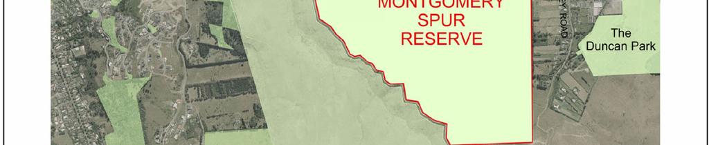
7 1 OVERVIEW 1.1 Introducing Montgomery In 1927 Montgomery Spur was purchased by John Montgomery, the son of the Honourable William Montgomery. John Montgomery, and then his son Jock, utilised the land for both grazing and seed exportation. John Montgomery unexpectedly passed away in 1946 after succumbing to illness in a very short time. Jock then farmed the land until new owners stepped in during the 1980 s. Grazing and stock work was common from this point up to the time of Council s acquisition of the land area. The name Montgomery Spur was subsequently taken from John Montgomery, but prior to the proposal to develop the land (late 1990 s), the name Montgomery Spur had not been widely used. Instead, many people linked the land with the names Glenelg Spur, Murray-Aynsley or Rāpaki. 1.2 Introducing Montgomery Spur Reserve Montgomery Spur Reserve is a classified Christchurch City Council scenic reserve on the Port Hills. It has a land area of hectares and is zoned Rural Hills. The City Plan has the following passage to describe the rural hills zoning: The topography of the Port Hills and its outstanding natural features, open landscape and rural characteristics, provide one of the most important visual amenities for the whole of the city, especially in terms of views of them from the city and views from them across the Canterbury Plains. This description fits Montgomery Spur Reserve very well. It is a place that one can experience views of the Canterbury plains and has a rural presence when viewing the Port Hills from the city or north and west Canterbury. Montgomery Spur Reserve is located at 70 Rāpaki Road, Hillsborough Christchurch, and rises to a maximum height of 285 metres above mean sea level. Montgomery Spur is situated directly east of the Rāpaki Track and offers unobstructed views across the plains and coast. The spur is one of the most notable landscape parcels in Christchurch s backdrop. The area has Mount Vernon Park (Managed by the Mt Vernon Farm Park Trust on behalf of the Port Hills Park Trust Board) to the west and Avoca Valley to the east. Montgomery Spur Reserve has a relatively easy gradient for walking. In recent years the neighbouring Rāpaki Track has become increasingly popular for its recreational value. It is expected that many who use Rāpaki Track will look to utilise Montgomery Spur Reserve as part of their recreation experience in the future. It is for this reason that the Christchurch City Council is endeavouring to Christchurch City Council DRAFT [2009] Page 1
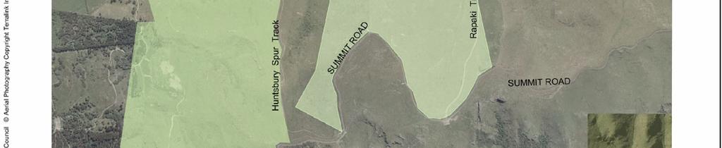
8 develop a plan to ensure this magnificent public asset is managed to the benefit of the community. The Montgomery Spur Reserve Management Plan is the first occasion such a document has applied to land title Part Lot 1, DP 2855, containing hectares, 25A/1227 Christchurch City Council, Scenic Reserve. 1.3 Purpose of the management plan The purpose of the management plan is to recognise the values of the reserve, establish a vision for its future, and set management objectives and policies to achieve desired outcomes. The plan has been developed in consultation with the public and follows the process outlined in the Reserves Act The Reserves Act section 41; 3. outlines the following: The management plan shall provide for and ensure the use, enjoyment, maintenance, protection and preservation, as the case may require, and to the extent that the administering body s resources permit, the development, as appropriate, of the reserve for the purposes for which it is classified, and shall incorporate and ensure compliance with the principles set out in section 19 as the case may be, of this Act for a reserve of that classification. 1.4 Ngāi Tahu: the Tangata Whenua The area of the Montgomery Spur Reserve is located within the takiwā of two Christchurch Papatipu Rūnanga - Te Hapū o Ngāti Wheke (Rāpaki) Rūnanga and Te Ngāi Tūāhuriri Rūnanga. In preparation of this Management Plan the relationships held by tangata whenua with the area have been identified and recommendations included to address the values held for the reserve and surrounding area, and there will be an ongoing relationship between the Council and the Rūnānga in the implementation of this Management Plan. One of the significant recommendations of the report, is for the use of a dual name for Montgomery Spur Reserve. As part of the development of the final plan, Ngāi Tahu will put forward a name to be used alongside Montgomery Spur Reserve. Other recommendations are addressed throughout this Management Plan and will be given effect to in the implementation of this Management Plan. 1.5 Rāpaki Track The Rāpaki Track is a benched track on legal road running alongside the western boundary of the reserve. It separates the reserve from Mt Vernon Park. The track starts at the end of Rāpaki Road and continues on to the Summit Road, partly through Mt Vernon Park administered land. It is one of the most used recreational areas of the Port Hills, being popular for mountain biking, walking and running. The gradient is ideal for people with low skill and fitness levels. Page 2 DRAFT [2009] Christchurch City Council
9 1.6 Historical trail for early settlers in Christchurch and Ngāi Tahu A path running down Montgomery Spur provided a link from Lyttelton Harbour through to the Canterbury Plains for Māori and for early European settlers. It was used by Ngāi Tahu when journeying between the Rāpaki settlement and the Kaiapoi settlement. In the 1840s the Deans brothers used it to take stock to their farm at Pūtaringamotu (Riccarton), and it was subsequently used by the early settlers of Christchurch as a route between Lyttelton and the city. (de Thier 1976 page 170, Ogilvie 1996 pages 42 44, Black Maps), ( 1.7 Mt Vernon Park Mt Vernon Park is privately owned by the Port Hills Park Trust Board who have set up the Mt Vernon Farm Park Trust to manage the area. The land lies to the west of Montgomery Spur Reserve. The Trust has a management plan much like this document with a list of objectives and policies by which they manage Mt Vernon Park. Thanks to the efforts of the Trust, the public can now access many areas of the Port Hills while utilising Mt Vernon Park. The Christchurch City Council urges the public to be aware and to respect the rules that the Trust has in place when accessing Mt Vernon from Rāpaki Track and Montgomery Spur Reserve. A copy of the Mt Vernon Park Management Plan can be found at the Christchurch Central City Library. Christchurch City Council DRAFT [2009] Page 3
10 2 VISION To maintain an open tussock landscape on Montgomery Spur Reserve through rural management that offers a recreational link to neighbouring areas of park land and scenic benefit to the public from either the Spur itself or as a backdrop to the city. 3 OBJECTIVES & POLICIES 3.1 Land management objective: The open space character, silver tussock, rock outcrop vegetation, matagouri and sheep grazing of the Spur are to be retained POLICIES: The open space and rural character of the reserve are to be conserved to optimise the benefits of public enjoyment and recreation in an outdoor setting Areas of significant vegetation (including matagouri and threatened rock outcrop plants) on the eastern slope of the reserve shall be protected from grazing damage The Council retains the right to manage woody weeds as a nurse species for establishing vegetation and protecting threatened species, while meeting the 10 metre boundary control obligations under the Regional Pest Management Strategy Weed control and other chemical applications on Montgomery Spur Reserve shall be undertaken so as not to compromise organic certificates of neighbouring property owners In situations where, in Council s opinion, any removal of vegetation or a surface is in a condition that poses a risk of erosion, the Council will exercise its right to manage the problem in an appropriate manner Management of vegetation shall be carried out by appropriate grazing methods that conserve the silver tussock grassland and other habitats of the reserve The indigenous rock outcrop vegetation is to be managed in a sustainable manner and grazing of these Page 4 DRAFT [2009] Christchurch City Council
11 areas is to be restricted if deemed necessary for their protection Trees and other plants will be selected according to their suitability to the environmental conditions, use of the site, and shall be managed with the primary aims of providing shelter, amenity, or ecological value In situations where, in the Council s opinion, any tree is in a condition that poses an immediate safety risk, the Council will exercise its right to have the tree removed as soon as possible Identified ecological values within the reserve are to be protected The habitats of the reserve shall be cared for in line with the Council s Biodiversity Strategy Timber could be retained on site where it offers the opportunity for habitat and benefit to the health of the land Several plant species of significance have been identified on the rock outcrops. These species and any others that are identified on the reserve shall be managed appropriately and spraying or top dressing not permitted in the areas that these are found. All known locations of such vegetation shall be recorded. Discussions need to be undertaken with the City Botanist and Planting Ranger before commencing with any work in the rock outcrop areas. 3.2 Cultural heritage & history objective: Cultural heritage is protected and history celebrated appropriately POLICIES: If anything of an archaeological nature is encountered (e.g. shells, charcoal-stained soil, fire-cracked stones, artefacts or human remains) during any programmes of work such as excavation, fencing, or roading etc, the NZ Historic Places Trust and Te Hapū o Ngāti Wheke (Rāpaki) Rūnanga are to be contacted immediately and work to be temporarily stopped Identified history of the reserve shall be recognised and incorporated into an interpretation plan for the reserve. Christchurch City Council DRAFT [2009] Page 5
12 3.2.3 Mahinga kai collection is enabled through appropriate planting in suitable areas on the reserve Pole markers on walking tracks shall be in the style of Pou Pou, their design, location and installation shall be undertaken in partnership with local Rūnanga. 3.3 Scenic & landscape objective: Views from the reserve and its landscape are protected and not forsaken POLICIES: Signage is to conform with Council signage guidelines, bylaws, standards, and policies. The size and location of signs in the Reserve are to be designed in such a way as to minimise visual detraction from the natural environment The scenic values of the reserve are to be retained and consideration given to those scenic values through any installation of tracks or other recreational and management facilities Opportunities for admiring the city from the slopes of the reserve are provided to optimise the recreational benefit to the public. 3.4 Recreation objective: Develop areas for recreation that are suitable for the reserve and surrounding environment POLICIES: Partnerships between the Council and adjoining land owners that work towards providing the public with quality recreational links and access shall be promoted Seating shall be kept at a minimum on the reserve Where possible marker poles will identify a route that optimises the publics recreational benefit of the reserve A mountain bike track that offers the opportunity for a step down in level from traditional Port Hills tracks should be provided that is classed as an easy grade track. Page 6 DRAFT [2009] Christchurch City Council
13 3.4.5 Organised events will be permitted in the reserve in accordance with Council policy and practise, and if it promotes outdoor recreational opportunities within the reserve Recreational structures and facilities are minimised to retain the open space character of the reserve Horses shall be permitted to access the reserve and utilise for riding on condition that they do not interfere with grazing activities, pedestrian or mountain bike users and that they do not access the rock outcrops or the gully systems unless a specific route is installed Recreational motorised activities will be restricted from utilising Montgomery Spur Reserve Activities involving projectiles shall not be permitted on Montgomery Spur Reserve unless the public and grazier are clearly informed or a lease or license allows such activity The naming of any recreational track shall take into consideration the historic ties of both Ngāi Tahu and the Deans of Canterbury stock route. 3.5 Access & links objective: Investigate options to gain quality access and links onto the reserve POLICIES: Council will retain the right to vehicle access onto the reserve where it meets management and maintenance goals Service vehicle access shall be provided via existing track networks on the reserve Access points are considerate of other users to ensure conflicts are limited Access points will be established between neighbouring reserve land or public trust land in partnership with administering bodies Links from Avoca Valley, Alderson Ave, Erewhon Tce, Glenelg Spur and Rāpaki Road and Track will be carefully investigated to optimise the benefits to the public and residents. Christchurch City Council DRAFT [2009] Page 7
14 3.6 Volunteers objective: Investigate volunteer aid for maintenance of the reserve POLICIES: Christchurch City Council Rangers, where appropriate, will seek volunteers input with maintenance of Montgomery Spur Reserve. 3.7 Farming activities objective: Farming will be utilised as a tool for land management POLICIES: Council will retain the right to use grazing as a management tool for reducing fire risk and managing vegetation in the reserve The public shall retain the right to access the working farm areas of the park where or when it does not conflict with the well-being of stock or adversely affect grazing operations. If restrictions are required, they will be indicated via appropriate signage Fence lines and styles shall not be placed on ridge lines, rather where possible they shall sit below ridge lines to ensure they have minimal impact on the scenic value of the Spur A lease shall be formulated between council and a grazier that adheres to the policies and objectives of this management plan Grazing will remain at a level where it will not place pressure through over or under grazing on the silver tussock. Assessments should be undertaken by the Grazier, the Christchurch City Council Grazing Ranger, with the City Botanist and Planting Ranger Dogs shall be prohibited from areas of Montgomery Spur Reserve during lambing season or where it is necessary for the health and well being of the stock. 3.8 Utility services objective: Allow access for essential utility services that are to the benefit of the environment, landscape and its visitors Page 8 DRAFT [2009] Christchurch City Council
15 POLICIES: Utility services necessary for the servicing of facilities within the reserve shall be permitted The visual and physical impact of services shall be minimised and services will be placed underground where possible Structures that detract from the open space character of the reserve that are not currently in place shall not be permitted unless it is providing an essential public benefit or it is to the benefit of the reserve Montgomery Spur Reserve will be considered as a litter free park, as such bins will not be provided, and reserve visitors are expected to take all rubbish with them. 3.9 Commercial activities objective: Commercial activities shall adhere to this management plan POLICIES: Commercial activities shall be discouraged when they do not meet the vision or objectives of this document Management plan review objective: To ensure that the management plan remains a useful tool for managers of the park POLICIES: Keep the management plan under continuous review in accordance with Section 41 (4) of the Reserves Act That the Montgomery Spur Reserve Management Plan when reviewed is aligned with similar plans of the Port Hills. 4 ISSUES Recreational use of the land: Two key issues have been raised in regards to recreation on Montgomery Spur Reserve, these being walking and mountain bike access. For mountain biking in particular it has been established that there is no easy grade track that offers an introduction from the plains to the hills. All other Port Hills mountain bike tracks have a grading of moderate, difficult or extreme. Montgomery Spur Reserve has the possibility if designed correctly to offer riders an easy grade Christchurch City Council DRAFT [2009] Page 9
16 track with great views. Such a track would not be at the technical level of other established Port Hill tracks. In recent times Rāpaki Track has become increasingly congested. Users of Rāpaki Track feel it is necessary for safety that another alternative is offered for people ascending or descending this point of the Port Hills. A route that offers the opportunity for people to loop through either Montgomery Spur Reserve, Rāpaki Track or through Mt Vernon s valley track will help to alleviate some of these concerns. Access and links onto the Spur: Staff and the public have identified the issue of accessing Montgomery Spur Reserve. At present the reserve is landlocked on two sides (Avoca Valley and from Alderson Avenue). The only access at present is off of the already very busy Rāpaki Road and Track. Residents from Avoca Valley and Alderson Avenue have stated a desire to have access from the eastern side of the reserve and away from Rāpaki Road. Rāpaki Road residents have stated that they would like an alternative access as Rāpaki Road becomes congested due to use of the Port Hills. Council Officers would need to look at alternative opportunities to access Montgomery Spur Reserve in order for any future links to be secured. Farming activities: Increased use of the area could put stress on stock at certain times of the year. Montgomery Spur Reserve is an important location for lambing. A balance needs to be created where the public retains the right to use the reserve while the health and well being of the ewes at lambing time is not forsaken. Grazing will be an important factor in retaining the silver tussock landscape for the future. People have stated that they would like to see farming and the silver tussock thrive and that the rural character of the land remains. In order for this to occur, Montgomery Spur Reserve needs to be an appropriate and attractive location for lambing and grazing. Botanical: Woody weed pests broom (Cytisus scoparius) and gorse (Ulex europaeus) have established a foothold on the lower western slope of the reserve. They have been identified as suitable as nursery crops to allow native vegetation to develop in their shelter and eventually replace them. The threat of erosion is another key factor in the desire to retain the broom and gorse while other vegetation establishes in their place. The public have stated that the 3 lines of trees on Montgomery Spur Reserve are important to the backdrop of Christchurch. However, others have stated that they do not wish to see pines or macrocarpa on the slopes of Montgomery Spur Reserve. One of the biggest issues in retaining trees in regard to the future of Montgomery Spur Reserve is the dry conditions due to soil type and the harsh climatic conditions to which the Spur is subjected. Any tree planting will need intensive management and care. Species will also need to be able to cope with Page 10 DRAFT [2009] Christchurch City Council


17 the environment on the slopes and it is important that at the present time the trees are offering shelter to stock on these slopes. Gully plantings will be more suitable to the area to ensure there is shelter for stock in the future. Silver Tussock on Montgomery Spur Reserve with Christchurch in the background. Scenic and landscape issues: The landscape has been identified as of national importance. Any track or other recreational development has to be wary of this value and not detract from it. The public was clear in their support for very low level development on the reserve, and that it should only be necessary infrastructure that is placed on the slopes of Montgomery Spur Reserve. A marker pole route (using Pou Pou as markers) for walking and considerate placement of surfacing for other recreational activities will allow for this to occur. Tangata Whenua: Council staff have worked with local Rūnanga to ensure that this draft Management Plan identifies and addresses Ngāi Tahu values and aspirations for this area. Continuing this relationship will ensure opportunity remains for involvement in the management of Montgomery Spur Reserve. Christchurch City Council DRAFT [2009] Page 11
18 5 RESOURCE INFORMATION 5.1 Land tenure Christchurch City Council holds the Certificate of Title and will manage the land with the potential for private grazier to hold stock on the reserve. 5.2 Legal status and classification Montgomery Spur Reserve is made up of the following title: Part Lot Part Lot 1, DP 2855, containing hectares, 25A/1227 Christchurch City Council, Scenic Reserve The reserve is classified as a scenic reserve under section 19, 1.A of the Reserves Act The purpose of a Scenic reserve is described in the Reserves Act 1977 as follows: 19 Scenic reserves (1) It is hereby declared that the appropriate provisions of this Act shall have effect, in relation to reserves classified as scenic reserves 19 Scenic reserves (1) (a)for the purpose of protecting and preserving in perpetuity for their intrinsic worth and for the benefit, enjoyment, and use of the public, suitable areas possessing such qualities of scenic interest, beauty, or natural features or landscape that their protection and preservation are desirable in the public interest The Act goes onto to describe a scenic reserve as an area that is managed for the public s access and enjoyment: 19 2) (b) The public shall have freedom of entry and access to the reserve, subject to the specific powers conferred on administering bodies by sections 55 and 56 of this Act, 19 2) (c) To the extent compatible with the principal or primary purposes of the retention and preservation of the natural or scenic values, open portions of the reserve may be developed for amenities and facilities where these are necessary to enable the public to obtain benefit and enjoyment from the reserve 5.3 Physical description Stock yards The stock yards are used for drafting during lambing season and for treatment of stock. The yards are easy to locate due to being directly east of the much used Rāpaki track. Upper western slope Page 12 DRAFT [2009] Christchurch City Council
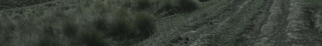
19 The upper western slope overlooks the Rāpaki track on the eastern side of Mt Vernon. This area is a logical link with Mt Vernon Park and Rogers track. The slope has stunning views looking towards the Canterbury Plains and the Southern Alps. In late afternoon the sun shines brilliantly over this area of the reserve as it sets in the west. The slope has fewer rock outcrops than one can find on the eastern side, however it offers true farm landscape. Eastern slope The eastern slope is dominated by the rock outcrops that form a spine along the ridge of the slope. On the northern areas of the slope dramatic drop-offs fall away into Avoca Valley. The slope has views over looking the New Brighton Pier, Pegasus Bay, the Southern Alps, central city, and Ferrymead. Lower western slope The lower western slope is dominated by broom and steep terrain. The slope is a favoured by stock due to the presence of water from the trough and the cover provided by the broom. Rock outcrops The rock outcrops on the reserve offer a stunning variation to the pasture land that dominates the area. The rocks are great locations for people to admire the views of the New Brighton Pier, Avoca Valley and the Mountain ranges surrounding Pegasus Bay. The rocks are strewn along the eastern slopes looking like relics and ruins from previous civilisations. Extensive rock outcrops occur above Avoca Valley, although covering a large area, they are not particularly steep. This allows stock easy grazing access to most, and the crevices have not been able to hold much in the way of native species as have less accessible rock outcrops at higher altitudes on the Port Hills. Smaller outcrops occur just above Rāpaki Track. They also have only fragmentary native vegetation. The main native plants on the rock outcrops are native shrubs. The very exposed upper rocks above Avoca Valley have low-growing appressed plants of prostrate kowhai (Sophora prostrata), porcupine shrub (Melicytus alpinus) and Coprosma propinqua, with pohuehue (Muehlenbeckia complexa) growing within them. Associated herbs include silver tussock and pasture grasses, but the low growing native Leptinella squallida is quite common. A small population of the highly threatened Banks Peninsula forget-me-not (Myosotis australis var. lytteltonensis) has recently been discovered on these outcrops away from the reach of grazing animals. The more sheltered cliffs have more upright shrubs, of which matagouri (Discaria toumatou) is the most notable. This plant is not at all common on the Port Hills and this may represent one of the larger populations of this shrub in the area. Silver tussock grassland The clumps of silver tussock are virtually the last native plant left amongst pasture grasses and herbs over most of the reserve. The ease of walking through Christchurch City Council DRAFT [2009] Page 13
20 the grassland will be of great value to people recreating on the Spur. The silver tussock grassed areas allow you to get a feel for how rugged the Port Hills are for stock and for those early settlers that had to cross over from Lyttleton when starting a new life in Christchurch. The city has few areas for true escape, while although Montgomery Spur does not entirely allow you to escape in the true sense, it certainly does allow for imagination and separation from city life. The silver tussock grassland is being maintained in its present state by grazing, but there has been considerable disagreement in regard to the appropriate management of such grasslands. However, apart from the need to control woody weeds, there appears little benefit to be gained from major adjustments to the current management regime which involves grazing by sheep. Lowering grazing intensity will likely result in the silver tussock being replaced by rank grass and weed growth, while intensive grazing, especially with cattle, is likely to further reduce tussock density. The difficult aspect of management is the need to control stock numbers in response to climatic extremes, especially drought. Gullies Montgomery Spur has three gullies running through the land. The eastern, central and western gullies. All three gullies over look the central city with trees lining the western side of each. Low rank vegetation occurs in each, with significant drop-offs from the central and western gullies. Table top This is noted as the highest point on the reserve, 285 metres above sea level. At the top of this point one can expect great views of Canterbury, Christchurch, Pegasus Bay, the Port Hills and the Southern Alps. 5.4 Climate Montgomery Spur Reserve is north-facing with high levels of radiant energy on its exposed slopes. The high levels of exposure to sun can be attributed to the area receiving virtually continuous light by facing north and its lack of shadow coverage from neighbouring landforms. Montgomery Spur Reserve can be best described as having a Mediterranean climate. It is subject to hot, dry conditions during the summer, and much like the Mediterranean, it has predictable levels of winter rainfall. During the depths of the Christchurch winter the spur has few frosts and only short term snow coverage. Montgomery Spur Reserve is subject to the Nor westor, and the various Easterly winds. The Nor westor is effective at drying the Spur out during the Summer months. The Easterly winds bring in rain from the Pacific and can be very unwelcoming for those on the eastern slopes. Southerly winds are more prevalent in winter and deposit most of the rainfall. Page 14 DRAFT [2009] Christchurch City Council
21 5.5 Soil Attached in the appendices under section 7.2 is a soil map. The map outlines soil type and its boundaries on Montgomery Spur Reserve. The following are soils of Montgomery Spur Reserve: Well drained basalt and loess soils: Cashmere hills soil Cashmere shallow silt loam, rolling phase Evans steepland soil Moderately drained basalt and loess soils: Clifton hills soil Scarborough hills soil Kiwi hills soil Imperfectly drained loess soil: Takahe deep silt loam Takahe hills soil While there are a number of soils that contribute to the make up of Montgomery Spur Reserve, they are not vastly different and do not signal the need for major changes in management type. 6 STRATEGIES AND POLICIES RELEVANT TO THE RESERVE Reserves Act 1977 Local Government Act 2002 Christchurch Biodiversity Strategy Canterbury Region Biodiversity Strategy Long Term Council Community Plan Christchurch City Plan Port Hills Recreation Strategy Christchurch Active Living Strategy 2004 Christchurch City Council Bylaws Christchurch City Council DRAFT [2009] Page 15
22 7 APPENDICES The following can be found in the appendices: 7.1 Council resolution on plan adoption 7.2 Soil map 7.3 City Botanist report 7.4 Tangata Whenua report 7.5 References 7.6 Indicative development proposals 7.7 Indicative development plan Page 16 DRAFT [2009] Christchurch City Council
23 7.1 Council resolution on plan adoption This resolution will take place once the Hearings Panel make their report to Council for adoption of the plan. This will then be placed in the adopted plan Christchurch City Council DRAFT [2009] Page 17

24 7.2 Soil map Page 18 DRAFT [2009] Christchurch City Council
25 7.3 City Botanist report by Trevor Partridge In June 2007 I visited parts of the Montgomery Spur Reserve on two occasions to determine the values and areas of indigenous vegetation. On the second occasion I was accompanied by Grant MacLeod to look at options for tracks to ensure that the botanical values are not compromised by their location. Montgomery Spur Reserve comprises a rounded ridge between the Rāpaki Track to the west, and the upper slopes of Avoca Valley to the east. It comprises pasture and rock outcrops at low to mid altitude on the Port Hills, so does not include the higher altitude elements that many of the large grassland reserves of the hills possess. It is currently used for grazing by sheep under a lease agreement. This report provides a brief description of the values of the reserve and comments on their location and the possible impacts of greater use by the public. It is proposed to create walking and cycling tracks and associated facilities within the reserve. Access in to the reserve is not straight forward and involves travelling either up or down Rāpaki Track to the easiest point of entry. Thus facilities in the reserve are likely to be of the wilderness type. Vegetation The pre-human vegetation of Montgomery Spur and indeed most of the lower Port Hills would have been mixed podocarp/hardwood forest dominated by tall trees such as totara (Podocarpus totara) and perhaps matai (Prumnopitys taxifolia). Dominant broadleaf trees would have included ribbonwood (Plagianthus regius), mahoe (Melicytus ramiflorus) and broadleaf (Griselinia littoralis) with tree fuchsia (Fuchsia excorticata) in gullies. The larger rock outcrops would have supported shrubland and silver tussock (Poa cita) where these were large enough to open the forest canopy. The first Europeans were greeted by completely different vegetation. Polynesian fires pushed the forest into the gullies and allowed the fire-tolerant low shrubs and especially silver tussock to dominate the landscape of the eastern Port Hills. Early paintings and photographs show the forest remnants confined to gullies and short tussock grassland the dominant vegetation. Farming activities have ensured the continuation of that pattern, but the introduction of new plant species such as gorse (Ulex europaeus) and pine (Pinus radiata) as well as pasture grasses created the landscape and vegetation seen today. Two main types of vegetation occur in the reserve today. Silver tussock grassland occurs on the deeper soils of the main part of the ridge itself and the rock outcrops support a mixture of silver tussock and native and exotic shrubs. Native forest has all but gone and its presence is only marked by the occasional tree amongst the more sheltered rock outcrops above Avoca Valley. Pines have however been planted as shelter belts on the rounded spurs. Silver tussock grassland Christchurch City Council DRAFT [2009] Page 19
26 The clumps of silver tussock are virtually the last native plant left amongst pasture grasses and herbs over most of the reserve. The tussock density varies from very sparse to about 20% cover, which is at the lower end of the gradual process of tussock to sward cover ratio. Only where severely overgrazed or where ploughed are tussock densities lower. Within the reserve the general pattern is of lower density at the lowest altitudes. The dominant pasture grass is browntop (Agrostis capillaris) with some crested dogstail (Cynosurus cristatus). Drier areas have Australian danthonia grasses (Rytidosperma spp.). There is a variety of associated herbs, but thistles, a common problem on the Port Hills, are not common. Other native species are uncommon and comprise the small yellow oxalis (Oxalis exilis) and small plants of the scrambling sub shrub pohuehue (Muehlenbeckia complexa). This grassland is being invaded by broom (Cytisus scoparius) and some gorse (Ulex europaeus) at the lower altitudes. In places this has formed a canopy and the overtopped vegetation is being displaced. Broom has the ability to occupy virtually the entire reserve so needs to be a major management consideration. The silver tussock grassland is being maintained in its present state by grazing. There has been considerable disagreement in regard to the appropriate management of such grasslands. However, apart from the need to control woody weeds, there appears little benefit to be gained from major adjustments to the current management regime which involves grazing by sheep. Lowering grazing intensity will likely result in the silver tussock being replaced by rank grass and weed growth, while intensive grazing, especially with cattle, is likely to further reduce tussock density. The difficult aspect of management is the need to control stock numbers in response to climatic extremes, especially drought. Rock Outcrops Extensive rock outcrops occur above Avoca Valley, although covering a large area, they are not particularly steep. This allows stock easy grazing access to most, and the crevices have not been able to hold much in the way of native species as have less accessible rock outcrops at higher altitudes on the Port Hills. Smaller outcrops occur just above Rāpaki Track. They also have only fragmentary native vegetation. The main native plants on the rock outcrops are native shrubs. The very exposed upper rocks above Avoca Valley have low-growing appressed plants of prostrate kowhai (Sophora prostrata), porcupine shrub (Melicytus alpinus) and Coprosma propinqua, with pohuehue growing within them. Associated herbs include silver tussock and pasture grasses, but the low growing native Leptinella squallida is quite common. The more sheltered cliffs have more upright shrubs, of which matagouri (Discaria toumatou) is the most common. This plant is not at all common on the Port Hills and this may represent one of the larger populations of this shrub. Associated shrubs include Coprosma crassifolia and C. propinqua and native broom (Carmichaelia arborea). Patches of bracken fern (Pteridium esculentum) occur amongst the shrubs. There are a very small number of conspicuous native trees, perhaps remnants of forest vegetation. Most appear to be mahoe. A few Page 20 DRAFT [2009] Christchurch City Council
27 native herbs were recorded, especially where sheltered from stock, including the ferns Polystichum richardii and Cheilanthes distans. Some unusual finds were single plants of leafless clematis (Clematis afoliata) and knobby clubrush (Ficinia nodosa) suggesting that a more thorough examination may reveal other examples of such occurrence. Botanical Values In the absence of an associated native flora, and at such low density, the silver tussock grasslands have very limited value. The rock outcrops do however have native vegetation of interest, especially as it contrasts with the more prominent higher altitude rocks of the Port Hills. These values have been recognised by their inclusion in two Ecological Heritage Sites (EHS) in the Christchurch City Plan. The smaller rock outcrops above Rāpaki Track are within the Mt Vernon Valley EHS 24.01, while the Avoca Valley cliffs form the lower altitude extension of Avoca Valley EHS Indeed the EHS includes the cliffs as they extend into private property below the Montgomery Spur Reserve there. At the upper part of the reserve, these two EHS s join. Impacts of Recreation Within the silver tussock grassland, it is very easy to create tracks that mostly avoid the silver tussock. If the inter-tussock included native species, there may be a problem, but as there are none, losses will be minimal. The rock outcrops require some care and sensitivity. However, as most of the native vegetation is shrub, it is relatively easy to identify such areas and avoid them in placing tracks through the outcrops. The most likely place that will need such attention are the Avoca Valley cliffs and there is an obvious sloping shelf at the upper end of the reserve that gives good access to lower altitudes and avoids major areas of shrubs at the same time.. The greatest threat to the vegetation of the reserve is not recreation but the spread of woody weeds, especially broom and gorse. These are spreading both through the silver tussock grassland and along the rock outcrops. Unless this spread is managed, the remaining botanical values of both habitats are under considerable threat. However, there is the suggestion that the sites in which the threatened species are found may instead be protected from grazing or exposure by the presence of shrubs of gorse and broom. Therefore it is important that these sites are marked and no clearing of any vegetation including weeds be undertaken until the roles of those species are determined in regard to the patches of threatened plants. As sites of threatened species, these areas will be monitored to determine the threats to these special plants. Christchurch City Council DRAFT [2009] Page 21
28 7.4 Tangata Whenua report by Andrea Lobb Andrea Lobb is the General Manager of Mahaanui Kurataiao Ltd a mandated Ngāi Tahu Rūnanga advisory agency that works to ensure Council documentation and programmes have appropriately engaged with Ngāi Tahu and adequately identified and addressed tangata whenua values in management planning and implementation. In the preparation of the Montgomery Spur Reserve Management Plan Mahaanui Kurataiao Ltd confirms that a constructive and effective engagement process has been undertaken. Dialogue with local Rūnanga has occurred, a report on tangata whenua values (Pauling 2008, Ngāi Tahu Cultural Values associated with the Montgomery Spur Reserve Area) was commissioned in the preparation of this Management Plan. The report identifies significant traditional associations of Ngāi Tahu with the broad area of Montgomery Spur, and in particular the Rāpaki track. Rāpaki track was one of four major ara tawhito (trails) linking the Ngāi Tahu settlement of Rāpaki and the resources of Te Whakaraupō (Lyttelton Harbour) with the kāika and pā (settlements) and mahinga kai (food and resources) of Ōtautahi and the major settlement of Kaiapoi Pā, It provided the most direct link between Rāpaki and Ōpawaho Pā, and from here to the mahinga kai resources of Te Ihutai (Avon-Heathcote Estuary). Key recommendations from this report and from dialogue with Rūnanga are included in this Management Plan through the objectives and development proposals, i.e., dual naming, mahinga kai habitat restoration and species plantings, interpretations, Pou Pou style trail posts. Council is also facilitating dialogue between Ngāi Tahu and neighbouring parties where recommendations are relevant to areas adjoining Montgomery Spur Reserve. Engagement with Ngāi Tahu will continue through the implementation of the Management Plan, through Mahaanui Kurataiao Ltd and the Rūnanga. Page 22 DRAFT [2009] Christchurch City Council
29 7.5 References Pauling, Craig (2008) Montgomery Spur Reserve Management Plan Tangata Whenua Research. Ogilvie, Gordon (1996) Pioneers of the plains; The Deans of Canterbury. Shoal Bay Press, Christchurch, New Zealand. de Thier, Walter (1976) Sumner to Ferrymead; A Christchurch history. Pegasus Press, Christchurch, New Zealand. Reference to the Black Maps: Christchurch City Council DRAFT [2009] Page 23
30 7.6 Indicative development proposals The indicative development proposals highlight the projects that would assist in achieving the objectives and policies of the management plan. The indicative development proposals will be used to identify significant expenditure items for which Council may choose to make provision in future Long Term Council Community Plans. Long-Term Council Community Plan (LTCCP) disclaimer No project recommended on the indicative development proposal will be implemented unless the expenditure is provided for through the Long Term Council Community Plan. Below is the list of projects that have been raised during the issues gathering phase of the management plan s development. Project Description Funding required Marker pole route Signage Walking route that is signalled by marker posts at intervals Pou Pou design & carving Traditional park signage that is informative Tangata Whenua information is authentic & appropriate Cost to be investigated Interpretation sign $2,500 Reserve name signs $800 per unit Internal track signage $300 per unit Access stiles over fences Install stiles on the park so that people and stock interaction is well managed $500 - $700 per unit installed Landscaping and planting program Landscaping and planting of areas outlined on the development plan Tangata Whenua values supported through gully planting and use of appropriate species Gully planting over a five year period: $502,200 for 6 ha Tussock planting 3m spacing s Kanuka planting 1.5m spacing s (including 3 yrs maintenance) Flax planting 1.5m spacing s (including 2 years maintenance and caged flax) Page 24 DRAFT [2009] Christchurch City Council
31 Mountain bike track Investigate option for a beginners mountain bike track and development Cost to be investigated Track from Erewhon terrace Rest stop Car park Investigate the development of a track from Erewhon tce that accesses the reserve Development of rest stop at a location with a significant view along the marker pole track Investigate option for car park on the perimeter of the reserve $20-$30 per metre $1000 for seat and rest area. Cost would need to be investigated along with suitable option. The developments above are not part of the statutory process of a management plan. In order to highlight the need for funding, it is necessary to develop a list of proposals as above. Please see following page for Indicative development plan Christchurch City Council DRAFT [2009] Page 25


32 7.7 Indicative development plan Page 26 DRAFT [2009] Christchurch City Council


33 Christchurch City Council DRAFT [2009] Page 27
34 Christchurch City Council DRAFT [2009] Page 1
Significant Natural Area Assessment. Property Name: Cochrane & Ashkel Ltd. Area Size (ha): 5.33
: 5.33") Private Bag 50072, Queenstown 9348, New Zealand QUEENSTOWN, 10 Gorge Road, Phone +64 3 441 0499, Fax +64 3 450 2223 WANAKA, 47 Ardmore Street, Phone +64 3 443 0024, Fax +64 3 450 2223 Significant Natural
Private Bag 50072, Queenstown 9348, New Zealand QUEENSTOWN, 10 Gorge Road, Phone +64 3 441 0499, Fax +64 3 450 2223 WANAKA, 47 Ardmore Street, Phone +64 3 443 0024, Fax +64 3 450 2223 Significant Natural
Land Management Summary
 photo credit: ANGAIR Anglesea Heath Land Management Summary The Anglesea Heath (6,501 ha) was incorporated into the Great Otway National Park in January 2018. This provides an opportunity to consider the
Potential additions to Aoraki/Mount Cook National Park and the World Heritage Area
 Topic Paper: Potential additions to Aoraki/Mount Cook National Park and the World Heritage Area. Purpose This paper provides the relevant background and matters for consideration regarding potential additions
A summary of Draft Makara Peak Mountain Bike Park Master Plan
 A summary of Draft Makara Peak Mountain Bike Park Master Plan OVEMBER 216 Image: Peter Marshall 2 3 Introduction Since it was established in 1998, the Makara Peak Mountain Bike Park (Makara Peak) has grown
1. The purpose of this report is to seek the Works, Traffic and Environment Committee s recommendation for:
 6. POUND ROAD ROAD STOPPING AND LAND SWAP General Manager responsible: General Manager City Environment, DDI 941-8608 Officer responsible: Authors: PURPOSE OF REPORT Asset and Network Planning Manager
Significant Natural Area Assessment. Property Name: Hillend Station
 Private Bag 50072, Queenstown 9348, New Zealand QUEENSTOWN, 10 Gorge Road, Phone +64 3 441 0499, Fax +64 3 450 2223 WANAKA, 47 Ardmore Street, Phone +64 3 443 0024, Fax +64 3 450 2223 Significant Natural
TOWPATH MOWING GUIDELINES
 TOWPATH MOWING GUIDELINES 24 September 2007 CONTENTS Introduction Scope and Status of Guidelines Influences on the Guidelines Health and Safety Biodiversity INTRODUCTION Towpath management is a key issue
Hawke s Bay Regional Parks Network. Pekapeka Regional Park Individual Park Plan
 Hawke s Bay Regional Parks Network Pekapeka Regional Park Individual Park Plan 2015-2024 Hawke s Bay Regional Council 159 Dalton Street Private Bag 6006 Napier 4110 Hawke s Bay New Zealand Telephone: 0800
NGA PUNA WAI and CANTERBURY AGRICULTURAL PARK MANAGEMENT PLAN 2010
 NGA PUNA WAI and CANTERBURY AGRICULTURAL PARK MANAGEMENT PLAN 2010 ACKNOWLEDGEMENTS Key stakeholders, user groups and Christchurch City Council staff were consulted in the preparation of the Nga Puna Wai
Continental Divide National Scenic Trail Legislative History and Planning Guidance
 Continental Divide National Scenic Trail Legislative History and Planning Guidance Legislation, Policy, and Direction Regarding National Scenic Trails The National Trails System Act, P.L. 90-543, was passed
PROTECTED AREAS ZONE - POLICY
 PROTECTED AREAS ZONE - POLICY.1 Introduction The Protected Areas Zone applies to the land depicted on the Ruapehu District Plan Maps as: Amenity Policy Area. Protected Areas - Conservation. (c) Protected
1 INFORMATION REQUIREMENTS
 1 INFORMATION REQUIREMENTS 1.1 BACKGROUND 2 1.2 WHAT IS THE DISTRICT PLAN 3 1.3 DISTRICT PLAN STRUCTURE 4 1.4 HOW TO USE THE DISTRICT PLAN 5 1.5 STRATEGIC FRAMEWORK 6 Whanganui District Plan (15 January
Recreation Management Plan Lake Baroon and Ewen Maddock Dam
 Lake Baroon and Ewen Maddock Dam December 2013 Contents Overview... 3 The Value of Our Natural Areas... 4 Management Approach... 6 Funding... 7 Recreation Management... 8 Conditions of Access and Use...
Draft Marine and Harbour Facilities Strategy
 Draft Marine and Harbour Facilities Strategy Vision The Coromandel peninsula is a destination of choice for safe, sustainable and accessible marine and harbour facilities that are fit for purpose to meet
Seek the Board s approval for the Donald Place kerb and channel renewal to progress to final design, tender and construction; and
 3. DONALD PLACE - KERB AND CHANNEL RENEWAL General Manager responsible: General Manager City Environment Officer responsible: Transport and City Streets Manager Author: Michelle Flanagan, Streets Capital
Park-specific management and policies Wainuiomata Recreation Area
 Park-specific management and policies Wainuiomata Recreation Area 6.8 Wainuiomata Recreation Area 6.8.1 Legal status Title held: Legislative status: Wellington Regional Council Administered under Local
Te Manahuna Consulting
 Assessment of the natural values at the proposed centre pivot irrigation site and surrounds on Ben Ohau Station, Mackenzie Basin, New Zealand August 2016 Abstract The natural values of the area proposed
Around and about Geraldine
 Around and about Geraldine A guide to recreational opportunities SOUTH CANTERBURY Track classifications Short walk Easy walking for up to an hour Track is well formed, with an even, welldrained surface.
Cooloolabin Dam Recreation Management Discussion Paper. November 2013
 Cooloolabin Dam Recreation Management Discussion Paper November 2013 Contents November 2013... 1 Background... 3 Overview of Cooloolabin Dam... 6 Weed Management... 7 Cultural Heritage... 7 Commercial
PSP 75 Lancefield Road. Northern Jacksons Creek Crossing Supplementary Information
 PSP 75 Lancefield Road Northern Jacksons Creek Crossing Supplementary Information September 2017 The northern crossing of Jacksons Creek proposed within the Lancefield Road PSP is a key part of the ultimate
Connie Rudd Superintendent, Black Canyon of the Gunnison National Park
 National Park Service U.S. Department of the Interior Black Canyon of the Gunnison National Park and Curecanti National Recreation Area Information Brochure #1 Wilderness and Backcountry Management Plan
This is a submission to Council s Delivery Plan and Operational Plan
 Goulburn Mulwaree Council Locked Bag 22 Goulburn NSW 2580 Emailed: strategy@goulburn.nsw.gov.au and council@goulburn.nsw.gov.au Marulan/Tallong Community Network C/O 843 Marulan South Road Marulan NSW,
The Vision for the San Juan Islands Scenic Byway
 The Vision for the San Juan Islands Scenic Byway 2 Judd Cove, Orcas Island, Courtesy of Kurt Thorson (kurtthorson.com) and San Juan County Land Bank Vision for the San Juan Islands Scenic Byway The San
Welcome to the future of Terwillegar Park a Unique Natural Park
 Welcome to the future of Terwillegar Park a Unique Natural Park 1 Introduction The Terwillegar Park Concept Plan study will develop an overall concept plan, management objectives and development guidelines
NATIONAL AIRSPACE POLICY OF NEW ZEALAND
 NATIONAL AIRSPACE POLICY OF NEW ZEALAND APRIL 2012 FOREWORD TO NATIONAL AIRSPACE POLICY STATEMENT When the government issued Connecting New Zealand, its policy direction for transport in August 2011, one
Submission on the Tukituki Catchment Proposal: EPA reference numbers; NSP 13/ , NSP 13/ , NSP 13/ , NSP 13/02.
 Hutt Valley Tramping Club PO Box 30 883 LOWER HUTT 5045 Tukituki Catchment Proposal Environmental Protection Agency Private Bag 63 002 WELLINGTON 6140 29 July 2013 Submission on the Tukituki Catchment
52. Richtersveld Cultural and Botanical Landscape (South Africa) (C 1265)
 (C 1265)") 52. Richtersveld Cultural and Botanical Landscape (South Africa) (C 1265) Decision: 32 COM 7B.52 The World Heritage Committee, 2. Having examined Document WHC-08/32.COM/7B.Add, 3. Recalling Decision 31
52. Richtersveld Cultural and Botanical Landscape (South Africa) (C 1265) Decision: 32 COM 7B.52 The World Heritage Committee, 2. Having examined Document WHC-08/32.COM/7B.Add, 3. Recalling Decision 31
The South Gippsland Koala. For over 60 years, the plantation industry has shared a unique relationship with the Strzelecki Koala. protection.
 The South Gippsland Koala For over 60 years, the plantation industry has shared a unique relationship with the Strzelecki Koala. protection harmony THE CO-EXISTENCE OF THE KOALA WITH THE PLANTATIONS co-existence
Committee. Presentation Outline
 CW-33-15 11/9/2015 Community and Corporate Services Committee November 10, 2015 1 Presentation Outline Background Vision and Objectives Study Process and Timeline Public and Stakeholder Engagement Organization
Rule Governing the Designation and Establishment of All-Terrain Vehicle Use Trails on State Land
 Rule Governing the Designation and Establishment of All-Terrain Vehicle Use Trails on State Land 1.0 Authority 1.1 This rule is promulgated pursuant to 23 V.S.A. 3506. Section 3506 (b)(4) states that an
Marchand Provincial Park. Management Plan
 Marchand Provincial Park Management Plan 2 Marchand Provincial Park Table of Contents 1. Introduction... 3 2. Park History... 3 3. Park Attributes... 4 3.1 Natural... 4 3.2 Recreational... 4 3.3 Additional
Draft Strategic Plans for Coillte s eight Business Area Units ( )
") Draft Strategic Plans for Coillte s eight Business Area Units (2011-2015) Response to Public Consultation from Mountaineering Ireland April 2013 1 Introduction Mountaineering Ireland welcomes this opportunity
Draft Strategic Plans for Coillte s eight Business Area Units (2011-2015) Response to Public Consultation from Mountaineering Ireland April 2013 1 Introduction Mountaineering Ireland welcomes this opportunity
MASTER PLAN EXECUTIVE SUMMARY
 Biscuit Run State Park Scottsville Road (State Route 20) Charlottesville, VA 22902 Biscuit Run State Park MASTER PLAN EXECUTIVE SUMMARY Department of Conservation and Recreation Division of Planning and
Procedure for the Use of Power-Driven Mobility Devices on Mass Audubon Sanctuaries 1 September 17, 2012
 Procedure for the Use of Power-Driven Mobility Devices on Mass Audubon Sanctuaries 1 September 17, 2012 Background As part of Mass Audubon s mission to preserve the nature of Massachusetts for people and
Wanaka Community Board 15 April Report for Agenda Item: 4
 Wanaka Community Board 15 April 2015 Department: Infrastructure Report for Agenda Item: 4 Mt Burke Station Stopping and Vesting of Road Purpose 1 To obtain the Board s support for a stakeholder agreement
ANAGEMENT. LAN November, 1996
 M ANAGEMENT P LAN November, 1996 for Paul Lake Provincial Park Ministry of Environment, Lands and Parks BC Parks Department Paul Lake Provincial Park M ANAGEMENT P LAN Prepared by BC Parks Kamloops Area
Steps in the Management Planning Process
 Steps in the Management Planning Process Developing a management plan for Kalamalka Lake Park will follow a multi-stage process. The planning process for this park is currently in the Draft Management
QLDC Council 14 December Report for Agenda Item: 13
 QLDC Council 14 December 2017 Department: Property & Infrastructure Report for Agenda Item: 13 New licence to E-Skate Limited to undertake guided electric skateboard tours along the Frankton Track Purpose
Theme: Predominately natural/natural appearing; rustic improvements to protect resources. Size*: 2,500 + acres Infrastructure**:
 Recreation Opportunity Spectrum (ROS) Classes The Recreation Opportunity Spectrum (ROS) provides a way to describe the variations in the degree of isolation from the sounds and influences of people, and
TAIERI MOUTH RECREATION RESERVE MANAGEMENT PLAN
 CLUTHA DISTRICT COUNCIL TAIERI MOUTH RECREATION RESERVE MANAGEMENT PLAN 26 June 2003 CONTENTS Page 1 PREFACE... 1 2 INTRODUCTION... 2 2.1 Location of Reserve... 2 2.2 Legal Description... 2 2.3 Purpose
ETOBICOKE CREEK NORTH TRAIL PROJECT. May 18, 2017 at Michael Power High School 105 Eringate Drive, Etobicoke ON M9C 3Z7
 ETOBICOKE CREEK NORTH TRAIL PROJECT May 18, 2017 at Michael Power High School 105 Eringate Drive, Etobicoke ON M9C 3Z7 1 Purpose of Open House The purpose of today s open house is to present the design
As outlined in the Tatshenshini-Alsek Park Management Agreement, park management will:
 Management Strategy General Strategy The priority management focus for the park is to ensure that its internationally significant natural, cultural heritage and recreational values are protected and that
URBAN DESIGN REPORT. Proposed Residential Development, Old Church Road, Caledon East
 Proposed Residential Development, Old Church Road, Caledon East TABLE CONTENTS: 1.0 DEVELOPMENT 1.1 Introduction-Analysis of Guiding Principles and Documents 1.2 Community Design and Architectural Design
Yard Creek Provincial Park. Management Plan
 Yard Creek Provincial Park Management Plan Draft January 2010 Yard Creek Provincial Park Management Plan Approved by: telàlsemkin/siyam/chief Scott Benton Bill Williams Squamish Executive Director ation
Perth and Kinross Council Development Control Committee 12 December 2012 Report of Handling by Development Quality Manager
 Perth and Kinross Council Development Control Committee 12 December 2012 Report of Handling by Development Quality Manager 4(3)(i) 12/570 Alterations and replacement windows at Milnathort Town Hall, 1
HISTORICAL AND SOCIAL SIGNIFICANCE PHOTOGRAPH: M.VAIR-PIOVA, 5/12/2014
 DISTRICT PLAN LISTED HERITAGE PLACE HERITAGE ASSESSMENT STATEMENT OF SIGNIFICANCE HERITAGE ITEM NUMBER 608 MILL ISLAND AND SETTING AVON RIVER BETWEEN HEREFORD-WORCESTER/71 HEREFORD STREET, 110 CAMBRIDGE
Bicentennial Park. Jill Hickie. Bushland Planner, Hobart City Council
 Bicentennial Park Jill Hickie Bushland Planner, Hobart City Council Bushland Management 2007-2017 Vision Statement The Council in partnership with the local community will retain, promote and enhance
SUBMISSION BY THE BOARD OF AIRLINE REPRESENTATIVES OF NEW ZEALAND ON THE DRAFT QUEENSTOWN LAKES DISTRICT COUNCIL DRAFT PLAN
 SUBMISSION BY THE BOARD OF AIRLINE REPRESENTATIVES OF NEW ZEALAND ON THE DRAFT QUEENSTOWN LAKES DISTRICT COUNCIL DRAFT PLAN Background to BARNZ BARNZ is an incorporated society comprising 19 member airlines
I508. Devonport Peninsula Precinct
 I508. Devonport Peninsula Precinct I508.1. Precinct description The purpose of the Devonport Peninsula precinct is to provide for the comprehensive residential development of the former Navy housing land
A Master Plan is one of the most important documents that can be prepared by an Airport.
 The Master Plan A Master Plan is one of the most important documents that can be prepared by an Airport. A Master Plan is a visionary and a strategic document detailing planning initiatives for the Airport
Walking Track Classification System Parks and Wildlife Service
 Appendix A Walking Track Classification Specifications Walking Track Classification System Parks and Wildlife Service This Walking Track Classification System is the outcome of a review of the track classifications
Arthur Carhart National Wilderness Training Center s Wilderness Investigations High School
 Arthur Carhart National Training Center s Investigations High School 101/Lesson 2 (OPTION 2B) Introducing the Act Goal: Students will understand the difference between wild spaces and federally designated
China Creek North Park Upgrades and Glen Pump Station. Park Board Committee Meeting Monday, July 10, 2017
 China Creek North Park Upgrades and Glen Pump Station Park Board Committee Meeting Monday, July 10, 2017 Purpose The purpose of this presentation is to: Share the results of the public engagement processes;
BELLHOUSE PROVINCIAL PARK
 BELLHOUSE PROVINCIAL PARK PURPOSE STATEMENT AND ZONING PLAN March 2003 1 BELLHOUSE PROVINCIAL PARK Purpose Statement and Zoning Plan Primary Role The primary role of Bellhouse Provincial Park is to protect
Thank you for this third opportunity to comment on the proposed revisions to the Coconino National Forest Management plan.
 March 19, 2014 Flagstaff Biking Organization PO Box 23851 Flagstaff, AZ 86002 Vern Keller Coconino National Forest Attn: Plan Revision 1824 South Thompson Street Flagstaff, Arizona 86001 coconino_national_forest_plan_revision_team@fs.fed.us
Schedule of Planning Applications Committee Date: 23 May Reference: 06/18/0064/F Great Yarmouth Officer: Mr J Beck Expiry Date:
 Schedule of Planning Applications Committee Date: 23 May 2018 Reference: 06/18/0064/F Great Yarmouth Officer: Mr J Beck Expiry Date: 24-04-2018 Applicant: Proposal: Site: Mr Mavroudis Clear weather hoardings
ROBERTS CREEK PROVINCIAL PARK MASTER PLAN. November, 1981
 Ministry of Lands, Parks and Housing Parks and Outdoor Recreation Division Park Operations Branch North Vancouver, B. C. ROBERTS CREEK PROVINCIAL PARK MASTER PLAN November, 1981 Mr. G. Trachuk Director
COMMISSION OF THE EUROPEAN COMMUNITIES. Draft. COMMISSION REGULATION (EU) No /2010
 No /2010") COMMISSION OF THE EUROPEAN COMMUNITIES Brussels, XXX Draft COMMISSION REGULATION (EU) No /2010 of [ ] on safety oversight in air traffic management and air navigation services (Text with EEA relevance)
COMMISSION OF THE EUROPEAN COMMUNITIES Brussels, XXX Draft COMMISSION REGULATION (EU) No /2010 of [ ] on safety oversight in air traffic management and air navigation services (Text with EEA relevance)
Loop Walks Key Criteria
 Loop Walks Key Criteria 1/31/2012 CONTENTS Mission... 3 Background... 3 Phase 1... 3 Guidelines... 3 Occasional Walker... 5 Level of Difficulty... 5 Loop Furniture... 6 1. Mapboard... 6 2. Waymarkers...
Reference: 06/13/0594/F Parish: Fritton & St Olaves Officer: Mrs M Pieterman Expiry Date:
 Schedule of Planning Applications Committee Date: 21 st January 2014 Reference: 06/13/0594/F Parish: Fritton & St Olaves Officer: Mrs M Pieterman Expiry Date: 20-01-2014 Applicant: Proposal: Site: Lord
Hauraki Maori Trust Board STRATEGIC PLAN
 Hauraki Maori Trust Board STRATEGIC PLAN FOR THE CUSTOMARY FISHERIES OF HAURAKI 2002-2052 1 This strategic planning document was developed for and approved by the Hauraki Maori Trust Board on 12 February
National Wilderness Steering Committee
 National Wilderness Steering Committee Guidance White Paper Number 1 Issue: Cultural Resources and Wilderness Date: November 30, 2002 Introduction to the Issue Two of the purposes of the National Wilderness
Pillar Park. Management Plan
 Pillar Park Management Plan January 2014 Pillar Park Management Plan Approved by: Jeff Leahy Regional Director Thompson Cariboo Region BC Parks January 9, 2014 Date Brian Bawtinheimer Executive Director
RESPONSE TO AIRPORT EXPANSION CONSULTATION 27 MARCH 2018 Submitted online by Helen Monger, Director
 RESPONSE TO AIRPORT EXPANSION CONSULTATION 27 MARCH 2018 Submitted online by Helen Monger, Director 1. Expanding Heathrow The expansion of Heathrow will be one of the largest infrastructure projects in
E40. Temporary activities
 E40. Temporary activities E40.1. Background Temporary activities contribute to Auckland's vibrancy and to the social, cultural and economic well-being of communities. Temporary activities also enable filming
National Park Service Wilderness Action Plan
 National Park Service U.S. Department of the Interior National Park Service Wilderness Action Plan National Wilderness Steering Committee National Park Service "The mountains can be reached in all seasons.
A21 TONBRIDGE TO PEMBURY DUALLING. Statement of Case
 A21 TONBRIDGE TO PEMBURY DUALLING Statement of Case In Respect of Applications for the Demolition of Listed Buildings Under the Provisions of the Planning (Listed Buildings and Conservation Areas) Act
Longmont to Boulder Regional Trail Jay Road Connection DRAFT FINAL REPORT
 Longmont to Boulder Regional Trail Jay Road Connection DRAFT FINAL REPORT December 2018 Project Summary Boulder County, Colorado, in partnership with the City of Boulder, is evaluating options for multi-use
Logo Department Name Agency Organization Organization Address Information 5700 North Sabino Canyon Road
 Logo Department Name Agency Organization Organization Address Information United States Forest Coronado National Forest 5700 North Sabino Canyon Road Department of Service Santa Catalina Ranger District
OUTDOOR AND ENVIRONMENTAL STUDIES
 Victorian Certificate of Education 2002 SUPERVISOR TO ATTACH PROCESSING LABEL HERE Figures Words STUDENT NUMBER Letter OUTDOOR AND ENVIRONMENTAL STUDIES Written examination Monday 18 November 2002 Reading
EAST DON TRAIL ENVIRONMENTAL ASSESSMENT. Community Liaison Committee Meeting #3 July 15, :30 to 8:30 pm Flemingdon Park Library
 EAST DON TRAIL ENVIRONMENTAL ASSESSMENT Community Liaison Committee Meeting #3 July 15, 2013 6:30 to 8:30 pm Flemingdon Park Library Agenda 1. Welcome 2. Housekeeping and Updates a) Housekeeping b) CLC
THRESHOLD GUIDELINES FOR AVALANCHE SAFETY MEASURES
 BRITISH COLUMBIA MINISTRY OF TRANSPORTATION & INFRASTRUCTURE AVALANCHE & WEATHER PROGRAMS THRESHOLD GUIDELINES FOR AVALANCHE SAFETY MEASURES British Columbia Ministry of Transportation & Infrastructure
Wilderness Areas Designated by the White Pine County bill
 Wilderness Areas Designated by the White Pine County bill SEC. 321. SHORT TITLE. This subtitle may be cited as the `Pam White Wilderness Act of 2006'. SEC. 322. FINDINGS. Congress finds that-- The White
15. BEXLEY RESERVE NORTH AVON BMX CLUB FORMALISATION OF LEASE/LICENCE
 15. BEXLEY RESERVE NORTH AVON BMX CLUB FORMALISATION OF LEASE/LICENCE General Manager responsible: General Manager City Environment, DDI 941-8608 Officer responsible: Authors: PURPOSE OF REPORT Transport
GLASS HOUSE MOUNTAINS PEAKS WALK, BEERBURRUM TRAILHEAD DRAFT CONCEPT PLAN
 GLASS HOUSE MOUNTAINS PEAKS WALK, BEERBURRUM TRAILHEAD DRAFT CONCEPT PLAN GLASS HOUSE Figure 1 REGIONAL WALK/RIDE OVERVIEW Aspirational Goal Create an interconnected nature-based recreation trail network
Specification for Grip blocking using Peat Dams
 Technical Guidance Note 1 Specification for Grip blocking using Peat Dams 1. Introduction Moorland drains (grips) have been dug across much of the Yorkshire upland peatlands. Many of these grips have become
COASTAL CONSERVANCY. Staff Recommendation March 25, 2004 SONOMA COUNTY COASTAL TRAIL, PHASE I. File No Project Manager: Richard Retecki
 COASTAL CONSERVANCY Staff Recommendation March 25, 2004 SONOMA COUNTY COASTAL TRAIL, PHASE I File No. 03-142 Project Manager: Richard Retecki RECOMMENDED ACTION: Authorization to disburse up to $455,000
Perth and Kinross Council Development Control Committee 27 August 2008 Recommendation by Development Quality Manager
 Perth and Kinross Council Development Control Committee 27 August 2008 Recommendation by Development Quality Manager 5(7) 08/414 Erection of kennels and cattery at Baltree Farm, Hatchbank, Kinross, KY13
City of Durango 5.8 FUNDING TRAILS DEVELOPMENT
 5.8 FUNDING TRAILS DEVELOPMENT The City has been successful in establishing dedicated local funding sources as well as applying for grants to develop the City s trail system, having received nearly $2.4
Daisy Dean Trail 628/619 ATV Trail Construction
 Background and Purpose and Need The Daisy Dean ATV Trail Construction Project is located in the Little Belt Mountains, Musselshell Ranger District, Lewis and Clark National Forest approximately 32 miles
Concept Curtin Precinct Map and Code
 Concept Curtin Precinct Map and Code Proposed changes from the revised Curtin Group Centre Draft Master Plan recommendations Disclaimer: This document is intended to show the proposed changes to the existing
The original needs analysis carried out in 2001 identified three options for acquiring or leasing land for the crèche:
 5. REDCLIFFS/SUMNER COMMUNITY CRÈCHE RELOCATION Officer responsible Author Property Manager Kevin Mara, DDI 941 6401 The purpose of this report is to update the Council on the status of this project, in
Proposed Peninsula Bay Bike Track Development
 Proposed Peninsula Bay Bike Track Development May 2018 BACKGROUND The area of land at the northern extreme of Wanaka's Peninsula Bay development (Lot 923 DP 501325), currently owned by Infinity Investment
Appendices A (Our ambition for nature (A3 plan) and further information)
 and further information)") Appendices A (Our ambition for nature (A3 plan) and further information) Penny Hill Farm Nature Conservation vision Key: Tenancy boundary Meadow restoration & Mowing/meadow F33 Mowing/meadow Progress towards
Appendices A (Our ambition for nature (A3 plan) and further information) Penny Hill Farm Nature Conservation vision Key: Tenancy boundary Meadow restoration & Mowing/meadow F33 Mowing/meadow Progress towards
WALKER SWAMP INFORMATION DAY Saturday 23 rd June 2018
 WALKER SWAMP INFORMATION DAY Saturday 23 rd June 2018 Introduction to the Upper Wannon River Floodplain wetlands and the new Walker Swamp Restoration Reserve Mark Bachmann and Greg Kerr, Nature Glenelg
ROAD AND TRAIL PROJECT APPROVAL
 ROAD AND TRAIL PROJECT APPROVAL www.marincountyparks.org Marin County Parks, 3501 Civic Center Dr, Suite 260, San Rafael, CA 94903 DATE: July 12, 2017 PRESERVE: Gary Giacomini Open Space Preserve PROJECT:
Order of the Minister of Environment #39, August 22, 2011 Tbilisi
 Registration Code 360050000.22.023.016080 Order of the Minister of Environment #39, August 22, 2011 Tbilisi On preparatory stages and procedure of the methodology for Elaborating structure, content and
Watchorn Provincial Park. Management Plan
 Watchorn Provincial Park Management Plan 2 Watchorn Provincial Park Table of Contents 1. Introduction... 3 2. Park History... 3 3. Park Attributes... 3 3.1 Natural... 4 3.2 Recreational... 4 3.3 Additional
Ouimet Canyon Provincial Nature Reserve. Management Plan
 Ouimet Canyon Provincial Nature Reserve Management Plan NOTE: This document has been scanned and formatted, and therefore is slightly different from the original version. -March 2002 Additional copies
Grade Crossing Regulations
 Grade Crossing Regulations An Overview of Municipal Roles and Responsibilities at Federally Legislated Grade Crossings March 21, 2017 presentation to Alberta Municipal Supervisor Association, Edmonton,
5.0 OUTDOOR RECREATION OPPORTUNITIES AND MANAGEMENT
 5.0 OUTDOOR RECREATION OPPORTUNITIES AND MANAGEMENT 5.1 Introduction This section describes the range of recreational activities that currently take place in Marble Range and Edge Hills Parks, as well
Decision Memo Broken Wheel Ranch Equestrian Outfitter Special-Use Permit Proposed Action
 Decision Memo Broken Wheel Ranch Equestrian Outfitter Special-Use Permit USDA Forest Service Mississippi Bluffs Ranger District, Shawnee National Forest Jackson and Union Counties, Illinois Proposed Action
The Kaimais Concept. Improving Outdoor Recreational Opportunities in Kaimai Mamaku Conservation Park From Backwater to Stomping Ground
 The Improving Outdoor Recreational Opportunities in Kaimai Mamaku Conservation Park From Backwater to Stomping Ground Background The Kaimai range is a band of hills providing a dramatic boundary between
Attendance Presentation
 TO The Community of Saanich FROM District of Saanich DATE January 30, 2017 RE Meeting Notes Haro Woods Jan 28th Community Engagement Goward House, 2495 Arbutus Road, Victoria BC Attendance In total, 18
Arrangements for the delivery of minor highway maintenance services by Town and Parish Councils
 Arrangements for the delivery of minor highway maintenance services by Town and Parish Councils Cabinet Date of Meeting 8 March 2017 Officer Cllr Peter Finney, Cabinet Member for Environment, Infrastructure
Welcome. Sustainable Eco-Tourism in the face of Climate Change. Presented by Jatan Marma
 Welcome Sustainable Eco-Tourism in the face of Climate Change Presented by Jatan Marma Definition Sustainable Development: is a process to meet the needs of the present without compromising the ability
I507 Devonport Naval Base Precinct
 I507. Devonport Naval Base I507.1. Precinct Description The Devonport Naval Base precinct covers most of the land held by the Crown for the HMNZ Naval Base (south yard) in Devonport. It incorporates the
Pembina Valley Provincial Park. Draft Management Plan
 Pembina Valley Provincial Park Draft Management Plan 2 Pembina Valley Provincial Park Table of Contents 1. Introduction... 3 2. Park History... 3 3. Park Attributes... 3 3.1 Natural... 3 3.2 Recreational...
Preferred Recreation Recommendations Stemilt-Squilchuck Recreation Plan March 2018
 Preferred Recreation Recommendations Stemilt-Squilchuck Recreation Plan March 2018 Below are the recommended recreation ideas and strategies that package together the various recreation concepts compiled
Perth and Kinross Council Development Management Committee 20 February 2013 Report of Handling by Development Quality Manager
 Perth and Kinross Council Development Management Committee 20 February 2013 Report of Handling by Development Quality Manager 4(4)(ii) 13/80 Replacement and re-positioning of street furniture, The Birks,