Appendix C: Consultant Report Heritage Landscapes
|
|
|
- Noel Thomas
- 6 years ago
- Views:
Transcription
1 Appendix C: Consultant Report Heritage Landscapes
2
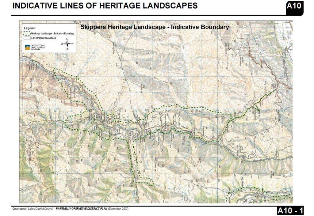
 encompasses a substantial portion of the Shotover River valley that includes the Skippers Road from Coronet Peak Road to the Shotover River.")
3 Queenstown Lakes District Council Heritage Landscapes Appraisals (based upon a desk-top appraisal of published information; September 2014) QLDC DP Ref: A10-1 Title: Skippers Heritage Landscape Description: The Skippers Heritage Landscape (SHL) encompasses a substantial portion of the Shotover River valley that includes the Skippers Road from Coronet Peak Road to the Shotover River. It then takes in the range of hills between the Shotover River and Green Gate Creek as far as the Maori Point Saddle and confluence with Stoney Creek; the boundary extends westwards up Stony Creek as far as Yates Terrace. From Stoney Creek Terrace, the heritage landscape extends north along either side of the Shotover River valley taking in the Skippers Township, the lower reach of Skippers Creek, and ending at Sandhill Cut, just north of the Shotover-Sandhill Creek confluence at the Branches Road. The topography of the Skippers Heritage Landscape includes the narrow, twisting, hillside route of the Skippers Road, the wide and frequently deep gorges of the Shotover River valley, the steep valley hillsides belonging to Coronet Peak and the Harris Mountain ranges and the previously flat sluiced terraces. Significant Elements: Includes a large number of the most significant archaeological sites relating to the historic Wakatipu gold rush and mining era of the 1860s and onwards. Includes the now-deserted, historic gold mining township of Skippers along with the 1901 suspension Bridge and restored Skippers Point School and Mt Aurum Homestead. Maori Point was one of the earliest and richest alluvial gold mining beaches in the Shotover Valley (1863) and its name records the finding of gold by two Māori prospectors, an uncommon record amongst the European-dominated mining sites. Skippers Road ( ) is famous for its precipitous and winding route to the Shotover River, which also incorporates a significant mining history and retains visible archaeological remains of the pack road revetting and construction techniques (1863). 1 P a g e
4 There are numerous archaeological gold mining sites within the SHL that include huts, water races, tailings, sluicing remains, pipes, cableways, dams and mining excavations. The Shotover Valley was one of the Māori traditional routes to the West Coast. The SHL encompasses one of the most dramatic and scenic valleys in the Wakatipu Basin and combines both significant natural history and historic heritage elements such as the Bridal Veil Falls and Pinchers Bluff. A small section of the SHL is within the much larger Mt Aurum Recreation Reserve (the former Mt Aurum Station) that is managed by the Department of Conservation. Summary Statement of Heritage Significance: The Skippers Heritage Landscape (SHL) represents some of the most historically and archaeologically significant, 19 th century gold mining sites in Otago and Southern New Zealand. Together, the diverse gold mining sites and features form an historically rich landscape that embodies the 1860s gold mining efforts and challenges of early miners, as well as later, more sophisticated mining technology that was needed to access the more difficult deposits of gold. In combination with the remote and stunning natural landscape of the Shotover River valley, the SHL offers a unique, largely intact, and publically accessible historic gold mining experience for visitors to the Shotover River. Within the SHL, the precipitous later 19 th century Skippers Road ( ), the deserted Skippers Township (1862) and the 1901 Skippers Suspension Bridge are all highly significant heritage sites that have been recognised by their Heritage New Zealand Pouhere Taonga listings. In addition, over 130 archaeological sites within the SHL are entered on the New Zealand Archaeological Association Archaeological Site Recording Scheme, demonstrating the outstanding heritage significance of the Skippers Heritage Landscape. Notes, Issues & Recommendations: There are 4 HNZPT listings within the SHL boundary (Mt Aurum Homestead and Skippers School complex, Category II; Skippers Road, Category I; Pleasant Terrace Workings, Category I; Wong Gongs Terrace Historic Area). NZAA sites: over 130 counted within the SHL boundary with a dense distribution of archaeological sites along the Shotover River from Sandhill Cut down to Stapletons Terrace, after which it thins out along the Skippers Road and Green Gate Creek. A small section of the SHL, focused on the Skippers Township area, lies within the Mt Aurum Recreation Reserve managed by Doc. The rationale for the SHL boundary appears to be based upon the spread of identified NZAA archaeological sites along the Shotover River, with a central focus on the Skippers Township area and incorporating the dense concentrations of gold working sites and huts immediately north of Skippers, the lower reach of Skippers Creek, the lower reach of Stony Creek, south of 2 P a g e
5 Skippers including Maori Point, and down to the Devil s Elbow. Outlying sites along Green Gate Creek (including the Green Gates Hotel site) and Skippers Road have also been included within the SHL boundary. The existing southern boundary is formed by Skippers Road itself. Inclusions/exclusions: The north end of the SHL boundary on the Shotover River and along Skippers Creek appears to have arbitrarily stopped at these points with identified archaeological sites omitted that are located fairly close by (e.g. within 150 metres). The boundary along the true right of the Shotover River below Maori Point Flat also omits a number of sites that lie immediately west of the boundary along the valley (e.g. Boomerang Terrace and Charlestown). The inclusion of Skippers Road reflects its listed status, but the boundary should be widened to include the environs of the road and Long Gulley. Recommendation: A detailed review of the boundaries to rationalise the included/excluded sites should be undertaken. The review should consider inter alia Whether the boundaries should be extended to some, or all, ridges to ensure that the full landscape character encapsulated in the SHL; How the boundaries around Skippers Road and Long Gully can be extended to ensure this crucial part of the SHL is included; and How unregistered, but still highly significant, features such as sluice terraces can be adequately recognised within the SHL. This review can only be undertaken by a site visit and more detailed assessment of the SHL. Threats & Vulnerabilities: Incremental loss of archaeological sites and features within the Skippers Heritage Landscape leading to a reduction of its overall heritage significance. Increased traffic volumes and road upgrading along both the Skippers Road and Branches Road may adversely impact the high level of heritage significance through a gradual loss of historic and archaeological features and the intrusive effects of higher traffic numbers. The formation of new tracks (particularly bike tracks) into and within the SHL has the potential to erode existing archaeological features and create a gradual degradation of the historic landscape quality of the area through the informal creation of side tracks and alternative routes from the main tracks. Key features to be protected: The Skippers Road and its historic revetments and construction features. The Skippers suspension bridge and former township area. All other known archaeological sites and listed historic places within the SHL. 3 P a g e
6 Unregistered archaeological sites, including sluiced terraces. Unobstructed views along the Skippers Canyon section of the Shotover River. 4 P a g e
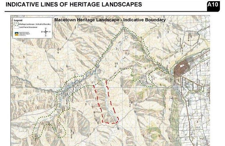
7 QLDC DP Ref: A10-2 Title: Macetown Heritage Landscape Description: The Macetown Heritage Landscape (MHL) encompasses the valley of the Gold or Rich Burn at its northern extent and continues south-east to its confluence with the Arrow River, taking in the lower reaches of a number of smaller creeks feeding into the Rich Burn. Its confluence with the Arrow River also marks the beginning of the mining ghost town of Macetown that is laid out along the banks of the Arrow River for approximately 2km. At the Mt Soho Homestead/Eight Mile Creek Hut, the MHL widens considerably, its boundary taking in the Arrow River to the east and the Big Hill Walkway to the west, ending just to the north of Arrowtown town centre. The topography of the Macetown Heritage Landscape includes the sinuous river valleys of the Rich Burn and Arrow River, the wide terrace of the Macetown Township, and the hilly terrain of Big Hill. Significant Elements: The Macetown Heritage Landscape is focused upon the now-deserted gold mining township of Macetown that has left many tangible traces of its plan, buildings and occupants from its founding in 1862 until its final desertion in the 1930s. The Macetown township is recognised by its designation as a historic reserve managed by the Department of Conservation. Macetown itself is a highly significant relic township of the early gold mining period whose significance lies in the evidence of alluvial (1860s) and quartz (1870s) mining remains, the surviving buildings (e.g. the bakehouse) and garden plans, and the park-like planting of species such as spruce and ash, and ornamental plants such as lilac and daffodils. Part of Macetown s significance is its remoteness, both historically and in the present, which resulted in the unusual preservation of portions of the town s plan and features allowing a greater level of interpretation and appreciation of what an historic gold mining town would have been like in the late 19 th century. The Macetown Heritage landscape encapsulates more than just the historic township of Macetown, but a much broader archaeological and historic mining landscape that includes significant sites and features in the Rich Burn valley (e.g. the Premier Battery, Anderson s Battery, and the Homeward Boundary Battery) and sites along the Arrow River south of Macetown, including the Shamrock Company water race, Soho mining camp, Scole s Tunnel, miners huts, and the Macetown road itself. Significant mining tracks within the MHL include the Macetown Road (completed 1884), Big Hill Track (the alternative route to Macetown; 1864), Hayes Creek Track and Advanced Peak Track. 5 P a g e
8 Summary Statement of Heritage Significance: Although it covers a large area, the Macetown Heritage Landscape is significant for its concentration of historic gold mining sites, focused on the deserted mining town of Macetown, which span from the earliest exploitation of gold in the Arrowtown area in 1862, through to the end of gold mining in the 1930s. Such a continuum of mining activity first alluvial then hard-rock or quartz has left a distinct and intelligible landscape with diverse features and stories linked by a series of mining tracks that still allow access to this remote and stunning countryside. The MHL encompasses three key areas: the Rich Burn valley, Macetown and the Arrow River valley, all three of which have distinctive characters and features that coalesce to form a broader mining heritage landscape of regional significance. Among these, Macetown is highly significant, representing the surviving remains of a remote 19 th century mining village to which stories are still attached and some history has been traced of its founders, occupants and demise. Situated within its larger mining heritage landscape context, Macetown can be interpreted as part of a community of gold mining activity sites, which are a key part of the wider Otago gold mining story. Notes, Issues & Recommendations: MHL is much more extensive than the Macetown historic reserve boundary (managed by DoC) and includes a large area to the south including Mt Soho Homestead, Hayes Creek, Saw Pit Gully, Big Hill and the lower reaches of the Arrow River. There are no HNZPT sites listed within the MHL. NZAA sites: approximately 34 archaeological sites included within the MHL. There are a number of sites lying just outside of the MHL boundary (e.g. 9 along the south side of the boundary along the Rich Burn) and which appear to be related to sites within the boundary (e.g. at the Homeward Bound Battery site). All of the key Macetown NZAA sites are included within the MHL, but the concentration of sites along the Eight Mile Creek, south-west of the Mt Soho Homestead site, are excluded. 7 sites included along the lower reaches of the Arrow River leading into Arrowtown with only two outlying sites excluded further up Soho Creek to the north-east of the boundary. The inclusion of the Rich Burn historic mining sites and the Big Hill and Arrow River sites is considered sensible as this reflects the broader mining heritage landscape context that the Macetown Historic Reserve is situated within. The exclusion of the Eight Mile Creek gold mining sites seems inconsistent given the inclusion of other comparable sites along the Rich Burn valley. Recommendations: A further review of the boundaries to rationalise the included/excluded sites, but essentially the current boundaries appear reasonable with the possibility of some minor alteration to include the Eight Mile Creek archaeological sites. The extent to which boundaries should be raised to ridge lines needs to be assessed on site. 6 P a g e
9 Possible re-naming of the Heritage Landscape to recognise the Rich Burn/Arrow River archaeological areas. Threats & Vulnerabilities: Incremental damage to, and loss of, archaeological sites and features within the Macetown Heritage Landscape from increasing visitor numbers to the Arrow River, Macetown and Rich Burn historic mining areas, leading to a reduction of its overall heritage significance. Increased damage to standing archaeological features such as the Macetown cottages and garden walls, hut sites and extant mining infrastructure (e.g. the crushing batteries) from increasing visitor access and interaction may adversely impact the high level of heritage significance through a gradual loss of historic and archaeological fabric. Any increase in off-road vehicles through the MHL and in particular, Macetown, has the potential to damage existing historic tracks, trails and other sensitive historic features, resulting in the gradual degradation of the historic and natural landscape within the MHL. The formation of new tracks into and within the MHL have the potential to erode surviving archaeological features such as existing mining tracks through the informal creation of side tracks and alternative routes from the main tracks. Key features to be protected: The Macetown Historic Reserve area including the Macetown Road. The Rich Burn mining remains (e.g. Anderson s Battery and the Homeward Bound Battery; the Sunrise Mine Office). The historic mining tracks of Hayes Creek, Sawpit Gully and Advance Peak and similar tracks within the MHL. All other known archaeological sites and listed historic places within the MHL. 7 P a g e
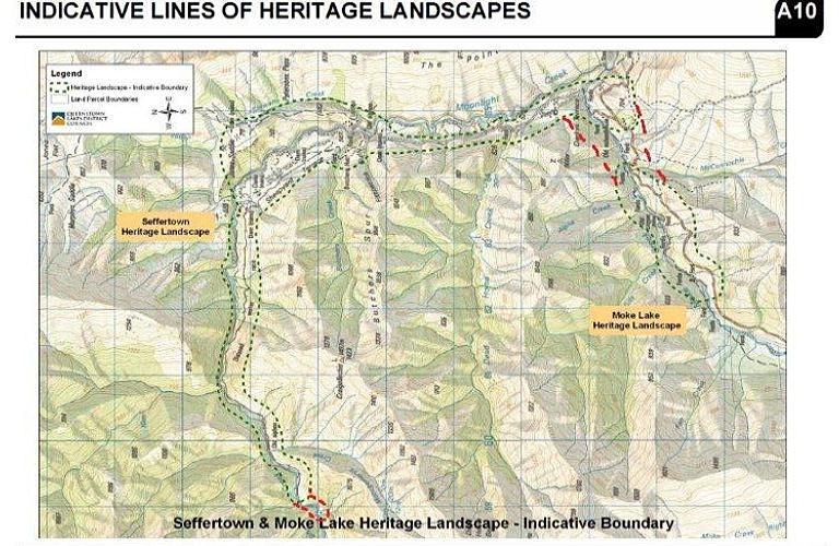
10 QLDC DP Ref: A10-3 Title: Seffertown & Moke Lake Heritage Landscape Description: The Seffertown and Moke Lake Heritage Landscape (SMLHL) encompasses two separately bounded areas. The Seffertown Heritage Landscape extends from Moonlight Creek, just west of its confluence with Montgomery s Creek on the eastern foot of the Richardson Mountains, and follows the Moonlight Creek south-eastwards until its confluence with Moke Creek. The Moke Creek Heritage Landscape begins approximately 500 metres downstream of the confluence, following Moke Creek for approximately 2.5 kilometres along either side of its banks. Both Heritage Landscapes are focused upon small, but significant early gold mining activity areas; Seffertown (or Sefferstown as it was also known) being the site of a former (alluvial) mining village located at the confluence of Moonlight and Moke Creeks with a complex of dams, huts and water races further north on the Sheepyard Terrace/Jones Saddle area of Moonlight Creek. Moke Creek was the location of a copper mine and alluvial gold mining. The topography of the SMLHL primarily includes the narrow valleys of the Moonlight and Moke Creeks, which cut through the more mountainous areas to the east and west, with smaller creeks feeding into them. Significant Elements: Seffertown was a gold rush tent village with over 3,000 occupants at its peak in 1863 and has an interesting history and longevity, with the last two villagers remaining into the 1950s and still connected with mining. Seffertown (or more accurately Sefferstown ) was named from its occupation by the large Seffers family (of Crimean/Russian origin) and contained several stores (the Seffers owned one), a hotel, post office and library. The settlement co-existed with Moke Creek village and a stone school building still stands that served both settlements. The archaeological remains of stone walls, hut foundations, at least two complete buildings (the Seffers house and Moke Creek School) and ornamental tree plantings (e.g. poplars) survive to mark the location of Sefferstown/Moke Creek. Moonlight Creek encompasses the extensive and clearly visible remains of the Moonlight gold fields, with a long (8.8km) water race (and siphons) running west-to-east to the alluvial mining remains at Sheepyard Terrace and further down the Moonlight Creek. The archaeological remains include earth and stone dams, earth reservoirs, sluicings and tailing piles, in-stream wing dams and hut sites. 8 P a g e
11 Moke Creek is significant for its (disused)copper mine, opened in 1863, and gold deposits discovered in Copper continued to be extracted into the 1930s and later, and the mine was still open in the early 1970s. Summary Statement of Heritage Significance: The Seffertown and Moke Lake Heritage Landscapes are significant for their concentrations of historic gold and copper mining remains, which include both mining infrastructure and settlement sites. The extensive and well-preserved complex of features along Moonlight Creek and Moke Creek are an important part of the wider history of the Wakatipu gold rush, linking closely with the Shotover River, Arrow River and Macetown/Rich Burn goldfields. Sefferton/Moke Creek was the site, albeit short-lived, of an early tented gold rush township that settled into a remote, mountain community that survived into the 1950s. It s remains provide tangible reminders of the many local stories that survive of the mining community and their hardships and life in the mountain goldfields of Otago. Issues & Recommendations: There are no HNZPT sites listed within the SMLHL. NZAA Sites: there are 2 archaeological sites within the SMLHL boundary (E41/200 and 202) and 2 related sites (E41/256 and 200) that are excluded from the extent of the SMLHL. The historic Moke Creek settlement and Seffertown are essentially the same/interrelated settlement site; the latter refers to its connection with the large Seffers family and appears to have been an alternative name for the Moke Creek village area. Recommendations: The possibility of the renaming of the Moke Lake HL to the Moke Creek Heritage Landscape should be considered to more accurately reflect its historic origins and geographic focus. Alternatively, it would make sense to amalgamate the two HL into one and consider renaming it the Moonlight Moke Creek Heritage Landscape. The current boundary should be slightly extended to include the two outlying NZAA sites (E41/256 and E41/201) to rationalise the inclusion of the known archaeological sites related to the SMLHL group. The extent to which boundaries should be raised to ridge lines needs to be assessed on site. Threats & Vulnerabilities: Incremental damage to, and loss of, archaeological sites and features within the Sefferton and Moke Lake Heritage Landscape from potential increases in visitor numbers to the historic mining areas via the Moke Lake Road access, leading to a reduction of its overall heritage significance. 9 P a g e
12 The formation of any new tracks into and within the SMLHL have the potential to erode surviving archaeological features such as existing mining tracks through the informal creation of side tracks and alternative routes from the main tracks. The risk of an increasing spread of pines and other masking vegetation in the Sheepyard Terrace section of the historic Moonlight mine features is likely to have an adverse impact upon the condition and legibility of the extensive surviving features (e.g. earth and stone dams, water races and tailings) in this area. Key features to be protected: The former mining settlement remains at Moke Creek/Sefferton including the surviving cottages/huts, gardens and plantings. The copper mining site along Moke Lake Road. Moke Lake Road and the historic track to Butchers Hut along the true right bank of the Moonlight Creek. The extensive stone and earthwork mining remains centred on Sheepyard Terrace and the Moonlight Creek. The 8.8km water race leading from above Montgomery s Creek to the Sheepyard Terrace area and below. All other known archaeological sites and listed historic places within the SMLHL. 10 P a g e
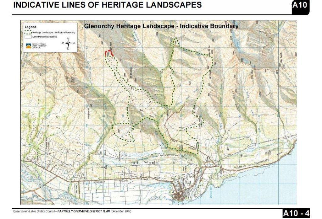
13 QLDC DP Ref: A10-4 Title: Glenorchy Heritage Landscape Description: The Glenorchy Heritage Landscape (GHL) lies to the east of Glenorchy township. It encompasses an area extending from Mount Judah Road, Mt Judah and Mt Alaska in the south, to the western slopes of Mt McIntosh to the north. A westerly spur in the boundary takes in a section of Long Gully and the slopes of the peak above. The focus of the GHL are the 19 th and 20 th century scheelite (tungsten ore) mines located primarily on Mt Judah, Mt McIntosh, Black Peak and Long Gully. The GHL also incorporates the tracks dating from the late 19 th and early 20 th centuries that were cut to access the different mines and bring the scheelite down to the battery on Mount Judah Road. The topography of the Glenorchy Heritage Landscape is mountainous with steep stream valleys and high peaks reaching nearly 2,000 metres ASL. Significant Elements: Represents an historic and more recent scheelite mining landscape a change from the dominant gold mining heritage landscapes found in the region although not fundamentally different in morphology. Although scheelite has been mined elsewhere in New Zealand, the Glenorchy mines area is significant as the main mining focus and producer of tungsten ore in the 19 th and 20 th century. Glenorchy scheelite mining commenced on a commercial level in 1885 with the Mt Judah Mine and continued until the 1980s with the Bonnie Jean and Heather Jock Mines, so has a continuity far longer than almost any of the historic gold mining fields. The clusters of mines, access tracks, cableway and water races on Mt Judah, Mt McIntosh and Black Peak form a distinctive and unique pattern of mining operations spread over a hundred year period that reflects the exploration and expansion of the scheelite mines across this area. The development of the mining activities within the Glenorchy Heritage Landscape have an accessible history that has been documented (e.g. Bradshaw 1997), and this provides further support for the significance of its scheelite mining heritage. The historic importance of scheelite/tungsten ore mining at Glenorchy was reflected in the take-over of the Mt Judah and Paradise Mines by the Government in 1942 to increase ore production for the war effort. 11 P a g e
14 Summary Statement of Heritage Significance: The Glenorchy Heritage Landscape is significant for its specific scheelite mining activities that extended from the 1880s until the 1980s, which have left a significant group of mine sites and infrastructure, along with a unique social history of the people who worked there. They in turn, represent the hard won and sometimes fruitless endeavours of a close-knit community of miners that spanned a hundred years of mining at Glenorchy. The GHL encompasses the majority of the key mine sites, tracks, a cableway and sections of water races that represented the primary scheelite producing area in New Zealand. The combination of private and stateowned mines is also a unique part of the GHL s history and one not paralleled in the ubiquitous and contemporary gold mining industry of the Wakatipu Basin. Overall, the scheelite mining history symbolised by the Glenorchy Heritage Landscape is a unique one of national heritage significance. Issues & Recommendations: There are no specific boundary issues for the GHL as the boundaries incorporate virtually all of the known scheelite-related mining sites within the area. There are no HNZPT sites listed within the Glenorchy Heritage Landscape. NZAA sites: there are 18 archaeological sites listed within the GHL and its boundaries incorporate all of the scheelite-related sites listed on the NZAA database. Three sites lie beyond the south-west boundary of the GHL, but these relate to gold mining activities and not scheelite mining. Inclusions/exclusions: The boundaries of the GHL appear to have included all of the listed archaeological sites in addition to many of the other scheelite mine sites and tracks that do not appear in the NZAA database (e.g. those on Black Peak and Mt Alaska). The boundary also includes a spur of land to the west of Long Gully that, presumably, has been included for the mine access track from Chinamans Flat, further west, to the Long Gully mines via a small, un-named peak. Recommendations: The extreme northern tip of the GHL boundary should be checked/revised to ensure it includes the Black Peak Mine that lies to the north-east of the summit. The extent to which boundaries should be raised to ridge lines should also be assessed on site. Threats & Vulnerabilities: Incremental damage to, and loss of, archaeological sites and features within the Glenorchy Heritage Landscape from potential increases in visitor numbers to the historic scheelite mining area via the Mount Judah Road access, leading to a reduction of its overall heritage significance. The formation of any new tracks into and within the GHL have the potential to erode surviving archaeological features such as existing mining tracks and 12 P a g e
15 mine openings and infrastructure, through the informal creation of side tracks and alternative routes from the main tracks. The scheelite mines at Glenorchy are not well known to the wider public and have a low level of information/signage available, which makes the interpretation and appreciation of their national heritage significance challenging. Key features to be protected: All mines, mining huts, the cableway and track ways within the Glenorchy Heritage Landscape boundary (including the Black Peak Mine). The more accessible mine sites along the Mount Judah Road. All other known archaeological sites and historic places within the GHL. 13 P a g e
16
17
18
19
Archaeological survey of the Arrow River and Macetown, Otago
 Archaeological survey of the Arrow River and Macetown, Otago Peter Petchey Published by Department of Conservation PO Box 10-420 Wellington, New Zealand Cover photograph The All Nations aerial cableway
Reservoir Tin workings
 The workings are quite over-grown and covered in moss, suggesting that they date to the earliest period of mining. This is supported by the fact that their head race was cut off by the reservoir (D49/47)
Archaeological survey of the Arrow River and Macetown, Otago. Peter Petchey
 Archaeological survey of the Arrow River and Macetown, Otago Peter Petchey Archaeological survey of the Arrow River and Macetown, Otago Peter Petchey Published by Department of Conservation PO Box 10-420
8.2 MINE ADIT. NZAA Site No. D49/25 G.R
 The settlement site was previously recorded as archaeological site D49/15, but the grid reference was wrong. This has been corrected and separate recordings made of the hotel site and landing site. The
CASTLE OF OLD WICK HISTORIC ENVIRONMENT SCOTLAND STATEMENT OF SIGNIFICANCE. Property in Care(PIC) ID: PIC282 Designations:
 ID: PIC282 Designations:") Property in Care(PIC) ID: PIC282 Designations: Scheduled Monument (SM90065) Taken into State care: 1957 (Guardianship) Last reviewed: 2004 HISTORIC ENVIRONMENT SCOTLAND STATEMENT OF SIGNIFICANCE CASTLE
Property in Care(PIC) ID: PIC282 Designations: Scheduled Monument (SM90065) Taken into State care: 1957 (Guardianship) Last reviewed: 2004 HISTORIC ENVIRONMENT SCOTLAND STATEMENT OF SIGNIFICANCE CASTLE
VISUAL Impact Assessment
 5.0 Existing Landscape Character TO GOULBURN FEDERAL HIGHWAY 5.1 Landscape Character Units Generally one of the first steps in carrying out a landscape and visual assessment is to identify and map the
PROPOSED PARK ALTERNATIVES
 8 Chimne y Rock State Park M a ster Pl an 2011 PROPOSED PARK ALTERNATIVES Introduction Three different park development concepts were prepared and presented to the citizens of North Carolina through a
December 2017 Quarterly Report
 ASX Announcement 31 January 2018 ASX: CRB December 2017 Quarterly Report KEY POINTS Continuation of work including final design criteria and front end engineering following Demonstration Plant test work
Specification for Grip blocking using Peat Dams
 Technical Guidance Note 1 Specification for Grip blocking using Peat Dams 1. Introduction Moorland drains (grips) have been dug across much of the Yorkshire upland peatlands. Many of these grips have become
NECHAKO CANYON PROTECTED AREA
 NECHAKO CANYON PROTECTED AREA PURPOSE STATEMENT AND ZONING PLAN March 2003 1 Nechako Canyon Protected Area Purpose Statement and Zoning Plan The Nechako Canyon Protected Area (1,246 hectares) is located
2.0 PARK VISION AND ROLES
 2.0 PARK VISION AND ROLES 2.1 Significance in the Protected Area System Marble Range and Edge Hills provincial parks protect 6.8% of the Pavillion Ranges Ecosection, which is located in the Southern Interior
Trail Count Report. For period: Oct March By: Mandy Kennedy for the Board of Trustees. Date: 03 April 2017
 Trail Count Report For period: Oct 18 2012 March 31 2017 By: Mandy Kennedy for the Board of Trustees Date: 03 April 2017 Executive Summary A total 1,294,144 trail journeys and 5,758,941 total trail movements
Dr. Dimitris P. Drakoulis THE REGIONAL ORGANIZATION OF THE EASTERN ROMAN EMPIRE IN THE EARLY BYZANTINE PERIOD (4TH-6TH CENTURY A.D.
 Dr. Dimitris P. Drakoulis THE REGIONAL ORGANIZATION OF THE EASTERN ROMAN EMPIRE IN THE EARLY BYZANTINE PERIOD (4TH-6TH CENTURY A.D.) ENGLISH SUMMARY The purpose of this doctoral dissertation is to contribute
4. Bronze Age Ballybrowney, County Cork Eamonn Cotter
 4. Bronze Age Ballybrowney, County Cork Eamonn Cotter Illus. 1 Location map of the excavated features at Ballybrowney Lower (Archaeological Consultancy Services Ltd, based on the Ordnance Survey Ireland
47I THE LAS ANIMAS GLACIER.
 THE LAS ANIMAS GLACIER. ONE of the largest of the extinct glaciers of the Rocky Mountains was that which occupied the valley of the Las Animas river. This stream originates in the San Juan mountains in
CULTURAL HERITAGE RESOURCES IMPACT ASSESSMENT ON MALOKONG HILL
 CULTURAL HERITAGE RESOURCES IMPACT ASSESSMENT ON MALOKONG HILL AFRICAN HERITAGE CONSULTANTS CC 2001/077745/23 Tel/fax: (012) 567 6046 Cell: 082 498 0673 E-mail: udo.heritage@absamail.co.za DR. UDO S KÜSEL
Proposed Arthurs Point Special Housing Area. Housing Accords and Special Housing Areas Act Expression of Interest
 Proposed Arthurs Point Special Housing Area Housing Accords and Special Housing Areas Act 2013 Expression of Interest 1.0 APPLICANT The applicant for the proposed Arthurs Point Special Housing Area is
Back Country Real Estate. Central Otago. Back Country
 Back Country Real Estate Central Otago Back Country 6-12 February 2017 Itinerary Join us on a new adventure as we discover the magnificent back country of the Central Otago region. We do however stress
April 10, Mark Stiles San Juan Public Lands Center Manager 15 Burnett Court Durango, CO Dear Mark,
 Mark Stiles San Juan Public Lands Center Manager 15 Burnett Court Durango, CO 81301 Dear Mark, We are pleased to offer the following comments on the draft San Juan Public Lands Center management plans
Proposal to Redevelop Lower Kananaskis River-Barrier Lake. Bow Valley Provincial Park
 Frequently Asked Questions Proposal to Redevelop Lower Kananaskis River-Barrier Lake Bow Valley Provincial Park Frequently Asked Questions What has been decided? What are the details of the plan? What
Trail Phasing Plan. Note: Trails in the Clear Creek Canyon area (Segments will be finalized in the future to minimize wildlife impacts
 Note: Trails in the Clear Creek Canyon area (Segments 2 5 and a future JCOS connection) will be finalized in the future to minimize wildlife impacts Trail Phasing Plan P Parking 3 Easy Trail Intermediate
ROBERTS CREEK PROVINCIAL PARK MASTER PLAN. November, 1981
 Ministry of Lands, Parks and Housing Parks and Outdoor Recreation Division Park Operations Branch North Vancouver, B. C. ROBERTS CREEK PROVINCIAL PARK MASTER PLAN November, 1981 Mr. G. Trachuk Director
Significant Natural Area Assessment. Property Name: Hillend Station
 Private Bag 50072, Queenstown 9348, New Zealand QUEENSTOWN, 10 Gorge Road, Phone +64 3 441 0499, Fax +64 3 450 2223 WANAKA, 47 Ardmore Street, Phone +64 3 443 0024, Fax +64 3 450 2223 Significant Natural
Looking north from the SW shieling site with Lub na Luachrach in the foreground
 Looking north from the SW shieling site with Lub na Luachrach in the foreground Upper Gleann Goibhre - Shieling sites Two shieling sites in the upper reaches of the Allt Goibhre were visited and recorded
Submission on the Tukituki Catchment Proposal: EPA reference numbers; NSP 13/ , NSP 13/ , NSP 13/ , NSP 13/02.
 Hutt Valley Tramping Club PO Box 30 883 LOWER HUTT 5045 Tukituki Catchment Proposal Environmental Protection Agency Private Bag 63 002 WELLINGTON 6140 29 July 2013 Submission on the Tukituki Catchment
SUBMISSION BY THE BOARD OF AIRLINE REPRESENTATIVES OF NEW ZEALAND ON THE DRAFT QUEENSTOWN LAKES DISTRICT COUNCIL DRAFT PLAN
 SUBMISSION BY THE BOARD OF AIRLINE REPRESENTATIVES OF NEW ZEALAND ON THE DRAFT QUEENSTOWN LAKES DISTRICT COUNCIL DRAFT PLAN Background to BARNZ BARNZ is an incorporated society comprising 19 member airlines
Lidar Imagery Reveals Maine's Land Surface in Unprecedented Detail
 Maine Geologic Facts and Localities December, 2011 Lidar Imagery Reveals Maine's Land Surface in Unprecedented Detail Text by Woodrow Thompson, Department of Agriculture, Conservation & Forestry 1 Introduction
Pinnacle Place QUEENSTOWN
 Pinnacle Place QUEENSTOWN QUEENSTOWN'S BEST From its grandstand view overlooking Queenstown Bay and Lake Wakatipu, 10 Pinnacle Place has an impressive internal space of 879 square metres, and 345 square
In the matter of The Resource Management Act And The Queenstown Lakes District proposed District Plan Topic 11 Ski Area Subzones mapping
 Before Queenstown Lakes District Council In the matter of The Resource Management Act 1991 And The Queenstown Lakes District proposed District Plan Topic 11 Ski Area Subzones mapping STATEMENT OF EVIDENCE
2.1 Physical and Biological Description Matabitchuan River Watershed
 2.1 Physical and Biological Description Watershed 2.1.1 Physical Description The system watershed has a total area of about 933 km 2 and is a tributary system to Lake Temiskaming and the Ottawa River Drainage
5 MAP SPECIFICATION FOR SKI-ORIENTEERING
 5 MAP SPECIFICATION FOR SKI-ORIENTEERING 5.1 General Maps for ski orienteering are based on the specifications for foot-orienteering maps. However in order to meet the specific requirements put on the
13.1 REGIONAL TOURISM ISSUES AND SUMMARY OF FINDINGS
 13 REGIONAL TOURISM T he County of Mariposa s recreation needs and facilities fall within two categories: regional tourism and local recreation. This Element focuses on regional tourism issues related
1.1.1 Landscape character This is the upper part of a bowl-shaped landform, extending east from the Rothiemurchus character area, contained by the
 1.1 Glen More 1.1.1 Landscape character This is the upper part of a bowl-shaped landform, extending east from the Rothiemurchus character area, contained by the arc of the high granite pluton of the Cairngorms
Excavations in a Medieval Market Town: Mountsorrel, Leicestershire,
 Excavations in a Medieval Market Town: Mountsorrel, Leicestershire, by John Lucas Mountsorrel is situated 12 kms north of Leicester and forms a linear settlement straddling the A6, Leicester to Derby road.
Hole in the Rock Scenic Backway
 Hole in the Rock Scenic Backway The Hole in the Rock Scenic Backway leads one along the pioneer path created by a Mormon Expedition. Approximately 55 miles one-way from Highway 12 to the Hole-inthe-Rock,
Wicklow Mountains Path Survey
 Wicklow Mountains Path Survey Glenmacnass Tonelagee Start to Finish: O 114 030 to O 085 016 Altitude (lowest highest): 370m 817m Weather: Sunny day, hot Access: Military Road, Glenmacnass Surveyed by:
FOUNDATIONS OF ARCHAEOLOGY A WALK IN VERNDITCH CHASE
 FOUNDATIONS OF ARCHAEOLOGY A WALK IN VERNDITCH CHASE 1. A Tale of two Long Barrows Long barrows were constructed as earthen or drystone mounds with flanking ditches and acted as funerary monuments during
Around and about Geraldine
 Around and about Geraldine A guide to recreational opportunities SOUTH CANTERBURY Track classifications Short walk Easy walking for up to an hour Track is well formed, with an even, welldrained surface.
APPENDIX OFFICIAL MAP ORDINANCE OF HAMILTONBAN TOWNSHIP OFFICIAL MAP NARRATIVE
 APPENDIX A OFFICIAL MAP ORDINANCE OF HAMILTONBAN TOWNSHIP OFFICIAL MAP NARRATIVE INTRODUCTION: The Official Map of Hamiltonban Township has been prepared to identify those lands and features that Hamiltonban
Wallace Lake Provincial Park. Management Plan
 Wallace Lake Provincial Park Management Plan 2 Wallace Lake Provincial Park Table of Contents 1. Introduction... 3 2. Park History... 3 3. Park Attributes... 4 3.1 Natural... 4 3.2 Recreational... 4 4.
Restore and implement protected status that is equivalent, or better than what was lost during the mid-1990 s
 THE ROSSLAND RANGE, OLD GLORY AREA. Executive summary. The Friends of the Rossland Range Society, on behalf of the local outdoor community, seeks to accomplish the following with respect to the Old Glory
PROTECTED AREAS ZONE - POLICY
 PROTECTED AREAS ZONE - POLICY.1 Introduction The Protected Areas Zone applies to the land depicted on the Ruapehu District Plan Maps as: Amenity Policy Area. Protected Areas - Conservation. (c) Protected
Guidance for Complexity and Density Considerations - in the New Zealand Flight Information Region (NZZC FIR)
") Guidance for Complexity and Density Considerations - in the New Zealand Flight Information Region (NZZC FIR) Version 1.0 Director NSS 14 February 2018 Guidance for Complexity and Density Considerations
Guidance for Complexity and Density Considerations - in the New Zealand Flight Information Region (NZZC FIR) Version 1.0 Director NSS 14 February 2018 Guidance for Complexity and Density Considerations
Region 1 Piney Woods
 Region 1 Piney Woods Piney Woods 1. This ecoregion is found in East Texas. 2. Climate: average annual rainfall of 36 to 50 inches is fairly uniformly distributed throughout the year, and humidity and temperatures
Proposal to Redevelop Lower Kananaskis River-Barrier Lake. Bow Valley Provincial Park. Frequently Asked Questions
 Proposal to Redevelop Lower Kananaskis River-Barrier Lake Bow Valley Provincial Park Frequently Asked Questions What is being proposed? What are the details of the proposal? Where is the project area located?
Kit Carson-Challenger Ridge Trail Project Annual Performance Report-2014 October 22, 2014
 1 Kit Carson-Challenger Ridge Trail Project Annual Performance Report-2014 October 22, 2014 Willow Lake and Kit Carson Peak 2 SUMMARY The Rocky Mountain Field Institute began Phase 1 of a multi-phase,
Ontario Municipal Board Commission des affaires municipales de l Ontario
 Commission des affaires municipales de l Ontario ISSUE DATE: July 25, 2014 CASE NO: PL130788 PROCEEDING COMMENCED UNDER subsection 17(36) of the Planning Act, R.S.O. 1990, c. P.13, as amended Subject:
Control Description Sheet 1
 Control Description Sheet 1 Headings I0A Example M20 M21 M35 1 8.8km 250m Event Title Classes (optional) Course Code; Course length, Height climb Start location as if it was a control. First Control Description
2009 No ANTARCTICA. The Antarctic (Amendment) Regulations 2009
 Regulations 2009") STATUTORY INSTRUMENTS 2009 No. 2354 ANTARCTICA The Antarctic (Amendment) Regulations 2009 Made - - - - 23rd August 2009 Laid before Parliament 1st September 2009 Coming into force - - 22nd September 2009
STATUTORY INSTRUMENTS 2009 No. 2354 ANTARCTICA The Antarctic (Amendment) Regulations 2009 Made - - - - 23rd August 2009 Laid before Parliament 1st September 2009 Coming into force - - 22nd September 2009
Wallace Lake Provincial Park. Draft Management Plan
 Wallace Lake Provincial Park Draft Management Plan Wallace Lake Provincial Park Draft Management Plan Table of Contents 1. Introduction... 3 2. Park History... 3 3. Park Attributes... 4 3.1 Natural...
Recreation Opportunity Spectrum for River Management v
 Recreation Opportunity Spectrum for Management v. 120803 Introduction The following Recreation Opportunity Spectrum (ROS) characterizations and matrices mirror the presentation in the ROS Primer and Field
City of Sydney Convenience Store Development Control Plan 2004
 City of Sydney Convenience Store Development Control Plan 2004 Table of Contents 1 Introduction 1 1.1 Citation 1 1.2 Area to which the plan applies 2 1.3 Commencement 1 1.4 Relationship to other environmental
There are actually six geographic sub-regions, three in both the uplands and the lowlands.
 6 Regions of AR Although Arkansas is most easily divided into two distinct geographical regions, the northwestern uplands and the southeastern lowlands, this description does not accurately portray the
General Summer and Winter Views
 ENVIRONMENTAL INFORMATION REPORT VOLUME 4 APPENDIX 11. 2 General Summer and Winter Views Table of Contents Section APPENDIX 11.2 Page 1 General Views... 1-1 Tansy Lane, Portishead... 1-2 Galingale Way,
Wanaka Community Board 15 April Report for Agenda Item: 4
 Wanaka Community Board 15 April 2015 Department: Infrastructure Report for Agenda Item: 4 Mt Burke Station Stopping and Vesting of Road Purpose 1 To obtain the Board s support for a stakeholder agreement
Whitemouth Falls Provincial Park. Draft Management Plan
 Whitemouth Falls Provincial Park Draft Management Plan Whitemouth Falls Provincial Park Draft Management Plan Table of Contents 1. Introduction... 3 2. Park History... 3 3. Park Attributes... 4 3.1 Natural...
ROUKEN GLEN: BANDSTAND 2015 DATA STRUCTURE REPORT
 ROUKEN GLEN: BANDSTAND 2015 DATA STRUCTURE REPORT Author (s) Ian Hill Editors Report Date June 2015 Working Partners Funders Phil Richardson East Renfrewshire Council East Renfrewshire Council, Heritage
The Entrance to Phillips Arm Cardero Channel
 The Entrance to Phillips Arm Cardero Channel Jason Zroback jason@landquest.com 1 (604) 414-5577 Jamie Zroback jamie@landquest.com 1 (604) 483-1605 The Source for Oceanfront, Lakefront, Islands, Ranches,
Guthega to Mt Twynam. 2183m. 1583m. 6 hrs 45 mins 14.8 km Return. Experienced only. 913m
 Guthega to Mt Twynam 6 hrs 45 mins 14.8 km Return Experienced only 5 913m This walk starts from Guthega and makes its way along the Snowy River to the Illawong Lodge, via the Blue Cow Creek flying fox.
Alternative 3 Prohibit Road Construction, Reconstruction, and Timber Harvest Except for Stewardship Purposes B Within Inventoried Roadless Areas
 Roadless Area Conservation FEIS Summary Table S-1. Comparison of Key Characteristics and Effects by Prohibition Alternative. The effects summarized in this table A would occur in inventoried roadless areas
Back Country Real Estate. Central Otago. Back Country
 Back Country Real Estate Central Otago Back Country 23-29 March 2018 Join us on a new adventure as we discover the magnificent back country of the Central Otago region. We do however stress that we are
Watchorn Provincial Park. Management Plan
 Watchorn Provincial Park Management Plan 2 Watchorn Provincial Park Table of Contents 1. Introduction... 3 2. Park History... 3 3. Park Attributes... 3 3.1 Natural... 4 3.2 Recreational... 4 3.3 Additional
ORION METALS LIMITED (ASX: ORM) ACTIVITIES REPORT FOR QUARTER ENDING 31 st August 2014.
 ACTIVITIES REPORT FOR QUARTER ENDING 31 st August 2014.") ORION METALS LIMITED (ASX: ORM) ACTIVITIES REPORT FOR QUARTER ENDING 31 st August 2014. EXPLORATION ACTIVITIES Orion s efforts towards project growth, evaluation, and rationalisation have been the focus
ORION METALS LIMITED (ASX: ORM) ACTIVITIES REPORT FOR QUARTER ENDING 31 st August 2014. EXPLORATION ACTIVITIES Orion s efforts towards project growth, evaluation, and rationalisation have been the focus
Procedure for the Use of Power-Driven Mobility Devices on Mass Audubon Sanctuaries 1 September 17, 2012
 Procedure for the Use of Power-Driven Mobility Devices on Mass Audubon Sanctuaries 1 September 17, 2012 Background As part of Mass Audubon s mission to preserve the nature of Massachusetts for people and
Establishing a National Urban Park in the Rouge Valley
 STAFF REPORT ACTION REQUIRED Establishing a National Urban Park in the Rouge Valley Date: March 29, 2012 To: From: Wards: Reference Number: Executive Committee Deputy City Manager, Cluster B All p:\2012\cluster
HUT POINT, ROSS ISLAND
 Measure 2 (2005) Annex K Management Plan for Antarctic Specially Protected Area No. 158 HUT POINT, ROSS ISLAND (including Historic Site and Monument No. 18, the historic Discovery hut of Captain R F Scott)
Potential additions to Aoraki/Mount Cook National Park and the World Heritage Area
 Topic Paper: Potential additions to Aoraki/Mount Cook National Park and the World Heritage Area. Purpose This paper provides the relevant background and matters for consideration regarding potential additions
Independent Technical Reference Group Wild Horse Damage around Currango Homestead Made by: Friends of Currango Inc. (FoC) Date: 13 April 2015
 Date: 13 April 2015") Submission to: Dr Mark Lonsdale Independent Chair Independent Technical Reference Group Re: Wild Horse Damage around Currango Homestead Made by: Friends of Currango Inc. (FoC) Date: 13 April 2015 Background
Submission to: Dr Mark Lonsdale Independent Chair Independent Technical Reference Group Re: Wild Horse Damage around Currango Homestead Made by: Friends of Currango Inc. (FoC) Date: 13 April 2015 Background
AN ARCHAEOLOGICAL ASSESSMENT OF BOERNE CITY PARK, KENDALL COUNTY, TEXAS. Thomas C. Kelly and Thomas R. Hester
 AN ARCHAEOLOGICAL ASSESSMENT OF BOERNE CITY PARK, KENDALL COUNTY, TEXAS Thomas C. Kelly and Thomas R. Hester Center for Archaeological Research The University of Texas at San Antonio Archaeological Survey
Park-specific management and policies Wainuiomata Recreation Area
 Park-specific management and policies Wainuiomata Recreation Area 6.8 Wainuiomata Recreation Area 6.8.1 Legal status Title held: Legislative status: Wellington Regional Council Administered under Local
Bear Creek Habitat Improvement Project
 06/10/10 Bear Creek Habitat Improvement Project El Paso County, Colorado Pike National Forest and Colorado Springs Utilities Owned Land Report prepared by: Eric Billmeyer Executive Director Rocky Mountain
Penrith Heritage Inventory
 Address: 1348-1362 Castlereagh Road Suburb / Nearest Town: Castlereagh 2749 Local Govt Area: Penrith State: NSW DUAP Region: Sydney West Historic region: Sydney Parish: County: Cumberland Other/Former
Bradley Brook Relocation Project. Scoping Notice. Saco Ranger District. United States Department of Agriculture Forest Service
 Bradley Brook Relocation Project United States Department of Agriculture Forest Service Scoping Notice White Mountain National Forest February 2011 For Information Contact: Jenny Burnett White Mountain
Illawarra Escarpment State Conservation Area Walking Tracks
 Illawarra Escarpment State Conservation Area Walking Tracks NPWS Illawarra Area Office Ground Floor, Government Office Block 84 Crown Street Wollongong NSW 2500 02 4223 3000 (Mon-Fri) Royal National Park
A21 TONBRIDGE TO PEMBURY DUALLING. Statement of Case
 A21 TONBRIDGE TO PEMBURY DUALLING Statement of Case In Respect of Applications for the Demolition of Listed Buildings Under the Provisions of the Planning (Listed Buildings and Conservation Areas) Act
Mount Meru Hiking / Climb
 Mount Meru Hiking / Climb Mount Meru is the second highest mountain in Tanzania and the fifth highest in Africa. Mount Meru is an active volcano located 70 kilometres (44 miles) west of Mount Kilimanjaro.
2.0 Physical Characteristics
 _ 2.0 Physical Characteristics 2.1 Existing Land Use for the Project The site is comprised of approximately 114 acres bounded by Highway 101 to the north, the existing town of Los Alamos to the east, State
The Kaimais Concept. Improving Outdoor Recreational Opportunities in Kaimai Mamaku Conservation Park From Backwater to Stomping Ground
 The Improving Outdoor Recreational Opportunities in Kaimai Mamaku Conservation Park From Backwater to Stomping Ground Background The Kaimai range is a band of hills providing a dramatic boundary between
Quick Start Track 1: Hokianga to Opua/Russell
 Quick Start Track 1: Hokianga to Opua/Russell Kaikohe to Okaihau section PROJECT DESCRIPTION The overall opportunity is to develop a 90-kilometre trail from the Hokianga Harbour on the West coast through
Subject to sale, withdrawal, or error.
 The Crawford L Bar Ranch is located approximately 40 air miles west of Albuquerque, New Mexico. This ranch truly epitomizes the description of New Mexico being the Land of Enchantment. The topography and
Proposed Peninsula Bay Bike Track Development
 Proposed Peninsula Bay Bike Track Development May 2018 BACKGROUND The area of land at the northern extreme of Wanaka's Peninsula Bay development (Lot 923 DP 501325), currently owned by Infinity Investment
Decision Memo Broken Wheel Ranch Equestrian Outfitter Special-Use Permit Proposed Action
 Decision Memo Broken Wheel Ranch Equestrian Outfitter Special-Use Permit USDA Forest Service Mississippi Bluffs Ranger District, Shawnee National Forest Jackson and Union Counties, Illinois Proposed Action
Request for Proposal National Tropical Botanical Garden Lower Limahuli Preserve Emergency Stream Debris Removal
 Request for Proposal National Tropical Botanical Garden Lower Limahuli Preserve Emergency Stream Debris Removal I. Summary of Work Bids are solicited for the emergency removal of debris deposited in the
Chapter 2: El Dorado County Characteristics and Demographics
 Chapter 2: El Dorado County Characteristics and Demographics 2.1 Geographic Area and Demographics El Dorado County comprises 1,805 square miles with over half of the area in the Eldorado National Forest
2018 Goldwedge Mines Inc. Licence of Occupation Management Plan. Photo: xxxx. Goldwedge Mines Inc.
 2018 2018 Goldwedge Mines Inc. Licence of Occupation Management Plan Photo: xxxx Goldwedge Mines Inc. March 2018 TABLE OF CONTENTS TABLE OF CONTENTS... i Figures... i 1. Background... 2 Project Overview...
Reference: 06/13/0594/F Parish: Fritton & St Olaves Officer: Mrs M Pieterman Expiry Date:
 Schedule of Planning Applications Committee Date: 21 st January 2014 Reference: 06/13/0594/F Parish: Fritton & St Olaves Officer: Mrs M Pieterman Expiry Date: 20-01-2014 Applicant: Proposal: Site: Lord
VOLUME II APPENDIX F DETAILED PHYSICAL DESCRIPTION OF PROJECT RESERVOIRS AND LANDS
 VOLUME II APPENDIX F DETAILED PHYSICAL DESCRIPTION OF PROJECT RESERVOIRS AND LANDS THE CENTRAL NEBRASKA PUBLIC POWER AND IRRIGATION DISTRICT FERC PROJECT NO. 1417 PHYSICAL DESCRIPTION OF PROJECT LANDS
Queenstown control zone amendments User consultation
 Civil Aviation Authority Table of Contents 1. Introduction... 1 2. Proposed changes... 1 NZT252 Ridge Peak... 1 NZG755 Coronet Peak... 2 3. Consultation... 3 4. Submissions... 4 5. Further information...
Pembina Valley Provincial Park. Draft Management Plan
 Pembina Valley Provincial Park Draft Management Plan 2 Pembina Valley Provincial Park Table of Contents 1. Introduction... 3 2. Park History... 3 3. Park Attributes... 3 3.1 Natural... 3 3.2 Recreational...
1. Waterfall Gully Mt Lofty. 5 Of the Best Hikes in Adelaide
 Adelaide is a beautiful city, and one of the most incredible things about Adelaide is the quality of bushwalking available on the suburban fringe. It is surrounded by the Mt Lofty Ranges, and much of the
Documentation of Mosaic Tangible Heritage in Jordan Jarash Governorate
 Documentation of Mosaic Tangible Heritage in Jordan Jarash Governorate Catreena Hamarneh, Abdel Majeed Mjalli, Mohamed al-balawneh Introduction In the year 2005 a project was launched to build up a data
wild women on top moonlight track & queenstown backcountry hike
 trip highlights Explore stunning Queenstown at your leisure Relax in the comfort and beautiful setting of Moonlight Lodge Exclusive backcountry hike on a private station Hike beneath mountains, over golden
Rogue Gorge (Mt. Stella) Roadless Area-- T30S R3E (primarily in portions of Sections 23, 26, 33, 34 & 35)
 Roadless Area-- T30S R3E (primarily in portions of Sections 23, 26, 33, 34 & 35)") Rogue Gorge (Mt. Stella) Roadless Area-- T30S R3E (primarily in portions of Sections 23, 26, 33, 34 & 35) Rogue River-Siskiyou National Forest--High Cascades Ranger District Upper, higher elevation trail
Rogue Gorge (Mt. Stella) Roadless Area-- T30S R3E (primarily in portions of Sections 23, 26, 33, 34 & 35) Rogue River-Siskiyou National Forest--High Cascades Ranger District Upper, higher elevation trail
This area is a popular holiday spot so watch out for 4WD vehicles and motorbikes at peak times.
 Mavora Walkway (Map 130, 129, 128) Southern Start Northern End Distance Time Track Standard Mavora Camping Area, Mavora Lakes Road Greenstone Station Road Carpark 50km 3 days Tramping track Hazards Never
TAYLOR CANYON RANCH COLORADO - ROUTT COUNTY - STEAMBOAT SPRINGS
 TAYLOR CANYON RANCH COLORADO - ROUTT COUNTY - STEAMBOAT SPRINGS Tucked up against the steep valley shaped by Mt. Pau and rising to the Routt National Forest, Taylor Canyon Ranch is an easily accessible,
EAST DON TRAIL ENVIRONMENTAL ASSESSMENT. Community Liaison Committee Meeting #3 July 15, :30 to 8:30 pm Flemingdon Park Library
 EAST DON TRAIL ENVIRONMENTAL ASSESSMENT Community Liaison Committee Meeting #3 July 15, 2013 6:30 to 8:30 pm Flemingdon Park Library Agenda 1. Welcome 2. Housekeeping and Updates a) Housekeeping b) CLC
Stage Travel southwards to the northern most airport at 3. Move off down the main East Coast Road to a fishing village in Doubtless Bay called
 In addition to finding the answers, you are also to map your progress on a giant map of NZ which you will you need to do either on your own or in a group. 1 2 3 4 5 6 7 8 M1 M2 M3 M4 Date Started Giant
Survey of An Dun. 24th March The Team: John Barnard and Graham Jackson.
 Survey of An Dun 24th March 2012 The Team: John Barnard and Graham Jackson. 1) Introduction An Dun (Section 5B, OS 1:50000 Map 42, Grid Ref. NN717805) is a Corbett and a Marilyn. This mountain has two
AMENDMENT NO. 03 TO THE OFFICIAL PLAN FOR THE TOWNSHIP OF ADJALA-TOSORONTIO OAK RIDGES MORAINE CONSERVATION PLAN
 AMENDMENT NO. 03 TO THE OFFICIAL PLAN FOR THE TOWNSHIP OF ADJALA-TOSORONTIO OAK RIDGES MORAINE CONSERVATION PLAN Adopted by Council July 19 th, 2004 Approved with modifications by the Province of Ontario
HORSEBACK RIDING. All rates are subject to service charges
 HORSEBACK RIDING The Local Loop Ride - A family-friendly 45-minutes to one hour ride around Dunton s east property. Perfect for children and adults who are new to riding. Easy terrain and beautiful views.