Juan Carlos Bravo Mexico Program Director Wildlands Network. Hermosillo, Sonora, Mexico, March 2017
|
|
|
- Dwayne Craig
- 5 years ago
- Views:
Transcription

1 BORDERLANDS CONNECTIVITY REPORT Advances in connectivity conservation in the borderlands of Sonora and Chihuahua, Mexico; and identification of border wall segments that need to remain undeveloped or that require mitigation actions to preserve connectivity for focal species. Juan Carlos Bravo Mexico Program Director Wildlands Network Hermosillo, Sonora, Mexico, March 2017 Border wall section in Nogales Arizona INTRODUCTION In recent years Mexican agencies, non-profit groups and academia have all made efforts to better address connectivity needs in the borderlands region of Sonora and northeastern Chihuahua. Some actions have focused on identifying impacts of U.S. border infrastructure, others have advanced protected area regulations, while still others seek to reduce habitat fragmentation generated by roads with a focus on Highway 2. Notable among these efforts are the wildlife crossings built in the Pinacate Biosphere Reserve; the designation of a core area of the Janos Biosphere Reserve along the border
2 with New Mexico; and the certification by Mexico s Parks agency (CONANP) of two private reserves along the border: Los Fresnos and Los Ojos. In addition to these actions, a coalition of groups and individuals from both Mexico and the United States has successfully collaborated with Mexico s Secretariat of Communications and Transport (SCT) in identifying and reducing the impacts of Highway 2 in the Sky Islands region of Sonora. Finally, researchers from different universities, agencies and institutions of both countries have increased our knowledge of what areas different species need to move across the border, and while much is still unknown, some places already stand out for their importance to wildlife connectivity. Much of this research does not provide easily available geographic data, hence my gratitude to the Arizona Ecological Services Office of the US Fish and Wildlife Service (USFWS), to the Instituto Nacional de Ecología y Cambio Climático, and to Dr. Rurik List of Universidad Autónoma Metropolitana-Lerma for making GIS data available on the areas of connectivity concern for jaguar, pronghorn and bison. This report is our first effort to put some of the information resulting from regulatory actions, wildlife-friendly infrastructure and research activities, into a series of maps that allows us to identify areas of the highest immediate concern for connectivity along the US border with Sonora and northwestern Chihuahua. Geographically explicit data is not as readily available as literature so this effort cannot contain all the research we are aware exists, nor does it cover all the different groups of fauna impacted by the border wall, as it focuses on a few wide-raging species for which data could be quickly collected. Known omissions in the region include black bear research in the Sierra San Luis region and bird migration routes, especially in the San Pedro River Basin. Should we be able to obtain geographic data for these groups and species we will update this report to incorporate them. REGULATING AND PLANNING FOR CONNECTIVITY Janos connectivity core area The Janos Biosphere Reserve has issued its management plan which includes maps and descriptions of its zoning. The plan identifies two polygons, as Corredor Fronterizo (Border Corridor) with a total surface of 11,729 hectares (29,000 acres) along the border with the United States, stating these represent crossing sites for pronghorn and bison, both listed in Mexico s NOM-059 (ESA equivalent) i. The plan further states these polygons are Core Areas important to maintain ecological and evolutionary processes of these two key grasslands species. It provides the areas with the most restrictions on use, to prevent changes that could affect migrating and dispersal patterns of these species along the border.
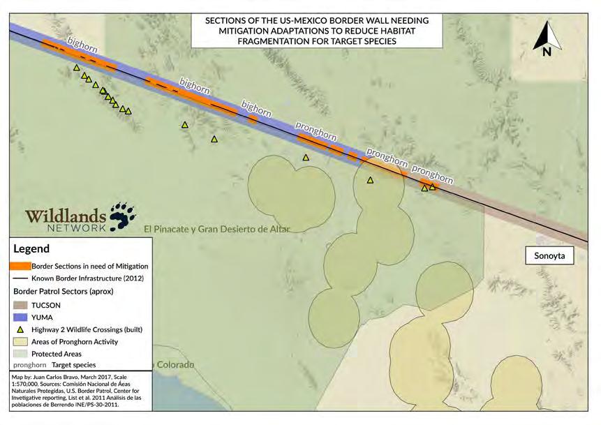
3 Border Private Lands Certification Two private reserves directly at the borderline in northeastern Sonora have been certified as Areas Voluntarily Destined for Conservation (ADVC for the Spanish acronym): Los Fresnos and Los Ojos ii. ADVC certifications are issued by Mexico s National Commission of Natural Protected Areas (CONANP) when landowners demonstrate that their properties have significant ecological value and commit to a selfregulation plan that promotes habitat conservation. These lands serve as platforms for regional conservation actions such as wildlife monitoring, habitat restoration and community outreach. Los Ojos, is not only located on the US-Mexico Border, it is also bisected by Highway 2 providing an ideal area for the establishment of wildlife crossings, and associated infrastructure (funneling fencing, exit ramps, etc.), protected from external disturbance, vandalism or theft. Highway 2: Cocóspera bypass re-routed Plans for a bypass to reduce transit time between Ímuris and Cananea were introduced to regional landowners in the summer of These plans included massive impact to over 16 miles of riparian habitat along the Cocóspera River on a known jaguar corridor. Wildlands Network, with help from volunteers, and from Carlos Robles Elías, owner of El Aribabi Conservation Ranch wrote a case for the protection of the Cocóspera iii and successfully collaborated with the Secretariat for Communications and Transportation (SCT) in identifying alternative routes that would not impact the river. The Environmental Impact Office of SCT agreed to change its plans and is now working on assessing a different route; it has further agreed to include wildlife crossings in any new plans iv. WILDLIFE CROSSINGS ON HIGHWAY 2 Wildlife crossings in Pinacate. In 2012 SCT began the expansion of Highway 2 in the Sonoyta-San Luis Río Colorado stretch. The environmental requirements set by the Pinacate y Gran Desierto de Altar Biosphere Reserve for this expansion included the establishment of wildlife crossings along the highway to allow for the movement of pronghorn, bighorn seep and species using riparian corridors. To date, 18 wildlife underpasses have been built in that stretch and evidence of use by bighorn sheep and other wildlife has been documented v. Wildlife crossings under review in the Sky Islands region Wildlands Network and its partners of the Wildlife Linkages Binational Partnership organized a trip for SCT personnel to visit the wildlife crossings on Oracle Road, just north of Tucson, hosted in part by the Regional Transportation Authority based in Tucson. After participating in the field visit, personnel of SCT requested initial recommendations to begin evaluating options for making the Agua Prieta - State limits stretch of Highway 2 more permeable to wildlife vi. They also agreed to fund an inventorying of all culverts, bridges and drainages from Ímuris to the State limit, as a first step to identify opportunities to convert some of these into effective wildlife
4 crossings. Recommendations were handed to SCT in January and are under review to assess viability with current budgets. These recommendations include 17 sites for wildlife crossings, six of which are marked as priority areas for the immediate raising of fencing and building of exit ramps, to allow existing bridges and culverts to serve as wildlife crossings, within the private protected area Los Ojos. Other recommendations include areas outside Los Ojos, areas that may need additional mitigation measures and areas targeted for further evaluation to determine their suitability as locations for future wildlife overpasses. Locations were determined with the help of culvert inventorying efforts, roadkill monitoring and landowner consultation. vii RESEARCH ON KEY BORDER CROSSING SPECIES Jaguar Connectivity models In 2015 the USFWS published a jaguar habitat-connectivity model viii, resulting from work with researchers from the Wildlife Conservation Society and the Jaguar Recovery Team, comprised of experts of both countries. While the model left out much potential habitat in Chihuahua, Arizona and New Mexico, it was the first publicly accessible GIS model of jaguar connectivity across the borderlands. It presents a matrix of habitat at a 1km/pixel resolution which highlights areas potentially used as corridors through the use of the Circuitscape software, which simulates an electric current running through that matrix as a proxy for jaguars navigating resistance on their path between two core habitat areas. A revision of the model, at a much higher resolution (30m/px), with a refined matrix and an updated version of Circuitscape is in production by scientists at Conservation Science Partners and should be published shortly. This report includes only the USFWS model. Status of pronghorn in Mexico In 2011 the Instituto Nacional de Ecología y Cambio Climático (INECC, at the time Instituto Nacional de Ecología) published a report ix on the status of pronghorn in Mexico, compiling a database with information from all the different populations of the species in three states: Chihuahua, Coahuila and Sonora. The report authors determined areas of pronghorn activity by defining buffers around each individual record of the species. Buffer sizes varied according to observed behavior in the populations of each state. The report s recommendations include one for the border wall: In areas used by pronghorn, require changes to existing people barriers which prevent the crossing of wildlife but not of people, and instead use vehicle barriers with a design that allows the crossing of medium and large mammals but prevent vehicles crossing. Status of border bison in Mexico In 2008 INECC also published a report x on the status of bison along the border of Chihuahua and New Mexico and concluded: The biggest threats to the population in Mexico used to be the expansion of farmlands in bison habitat, and illegal hunting. Nonetheless, a greater threat has emerged: the construction of the border wall. It will obstruct the free movement of bison across both countries Among its many findings
5 the report identified 5 places where bison crossed the border, one place where pronghorn crossed and one black bear track nearby. Recommendations include the establishment of wildlife crossings along the border, especially in areas east of the crossing named El Berrendo. SOURCES i Programa de Manejo Reserva de la Biósfera Janos. México, Secretaría de Medio Ambiente y Recursos Naturales. ii Website: Áreas Destinadas Voluntariamente A La Conservación. México 2016, Comisión Nacional de Áreas Naturales Protegidas: iii Rorabaugh J., C. Robles, K. Cooper & J.C. Bravo. Análisis de la Biodiversidad y posibles impactos ambientales de las modificaciones propuestas a la Carretera Federal 2 en su tramo Ímuris Cananea. Hermosillo, Unpublished. Presented by Wildlands Network to SCT. iv Bravo, J.C. Protection of the Cocóspera River. Project Report. Hermosillo Unpublished internal document of Wildlands Network. v Horacio Ortega, Subdirector of Reserva de la Biósfera Pinacate y Gran Desierto de Altar. Pers. Comm. March 2016 vi Bravo, J.C. Is Mexico Highway 2 the End of the Line for Jaguars and Wolves? Hermosillo, The Wildlands Network Blog. vii Bravo, J.C., M. Manteca, S. Hammer, J.M. Pérez, J. Schipper & T. Clevenger. Recomendaciones Iniciales para realizar obras de Mitigación de Impacto Ambiental en el tramo Agua Prieta-Límite de Estados de Carretera Federal #2. Hermosillo, Unpublished. Presented by Wildlands Network to SCT. viii Stoner, K. J., A. R. Hardy, K. Fisher, and E. W. Sanderson Jaguar habitat connectivity and identification of potential road mitigation locations in the Northwestern Recovery Unit for the Jaguar. Wildlife Conservation Society final draft report to the U.S. Fish and Wildlife Service in response to Solicitation F14PX00340, submitted 16 March pp. ons%20final%20-%20contract%20f14px00340.pdf ix List, R., M. Valdés and H. Zarza Villanueva. Análisis de las poblaciones de Berrendo (Antilocapra Americana) en Chihuahua y diseño de un método para su monitoreo. Informe Final INE/PS México Instituto Nacional de Ecología. x List, R. and V. Solís. Diagnóstico sobre el estado actual de la población de Bisonte Americano (Bison bison) en la frontera entre México y Estados Unidos y recomendaciones para su conservación y manejo. INE/A1-002/2008. Mexico Instituto Nacional de Ecología.

6


7
Dr. Melissa Grigione And Kurt Menke. Jaguar -Arturo. Jaguarundi -Arturo. Ocelot -Arturo. Caso. Caso. Caso
 Identifying Priority Conservation Areas in the U.S.- Mexico Border Region for America s Neotropical Cats, the Jaguar, Jaguarundi and Ocelot: An International Effort Dr. Melissa Grigione And Kurt Menke
Content. 15 Years of Conservation Initiatives. What is El Carmen? El Carmen in Figures. Awards and Achivements. Collaboration
 Content p 3 What is El Carmen? CEMEX biodiversity conservation legacy. p 13 15 Years of Conservation Initiatives 2016 represents 15 years of continuous conservation. p 4 El Carmen in Figures It is part
ECOSYSTEM CONSERVATION WORKING TABLE ACTION ITEM REPORT XX Trilateral Committee Meeting San Diego, California April 13 17, 2015
 The Working Table conducted its working session on April 13-16, 2015. The following Items were agreed upon and address the current priorities of the Trilateral Committee. o Climate Change with a Focus
Preferred Recreation Recommendations Stemilt-Squilchuck Recreation Plan March 2018
 Preferred Recreation Recommendations Stemilt-Squilchuck Recreation Plan March 2018 Below are the recommended recreation ideas and strategies that package together the various recreation concepts compiled
The Sonoran Desert Conservation Plan. Our Land, Our Home, Our Way of Life
 The Sonoran Desert Conservation Plan Our Land, Our Home, Our Way of Life Coalition for Sonoran Desert Protection The Sonoran Desert Conservation Plan The Sonoran Desert Conservation Plan is a comprehensive
The Baja 1000 car race and its impact on rural communities
 Sustainable Tourism IV 449 The Baja 1000 car race and its impact on rural communities J. Soares1, R. Blanco2, J. Tapia3, J. R. Lerma3, E. Inzunza1 & S. Avilés4 1 Engineering Faculty, Universidad Autónoma
Dr. Christopher Brown New Mexico State University GEF Project Rio Meeting Ciudad Juárez, México 3-5 October 2006
 Political and Institutional Aspects of Rio Grande/ Río Bravo Basin Management Dr. Christopher Brown New Mexico State University GEF Project Rio Meeting Ciudad Juárez, México 3-5 October 2006 Institutional
UPDATE REPORT OCTOBER Conservation of Marine Resources in Central America. Mesoamerican Reef Fund /
 OCTOBER 2012 Mesoamerican Reef Fund www.marfund.org / info@marfund.org Dear Friends, Picture by MAR Fund Besides the amazing news about the endowment fund granted to us by the Government of Germany through
Thursday, May 30, :00 to 3:30 PM Eastern Time. Preliminary Program
 Thursday, May 30, 2013 2:00 to 3:30 PM Eastern Time Preliminary Program To register for this webinar go to http://www.planning.org/cm/search/event.htm?eventid=23347 For more information contact us at rleiter9@san.rr.com
The Design of Nature Reserves
 The Design of Nature Reserves Goals Maintenance of MVP s for targeted species Maintenance of intact communities Minimization of disease Considerations of reserve design 1. Disturbance regime Fire Insect
Land Use. Grasslands and Rangelands National Parks and Reserves. Thursday, October 9, 14
 Land Use Grasslands and Rangelands National Parks and Reserves MANAGING AND SUSTAINING GRASSLANDS Almost half of the world s livestock graze on natural grasslands (rangelands) and managed grasslands (pastures).
Binational Cooperation in the Big Bend Region
 Binational Cooperation in the Big Bend Region Joe Sirotnak The early advocates for preserving a large conservation area in the Big Bend region were big thinkers. Even before Big Bend National Park itself
PELICAN ISLAND COMMUNITY PARTNERSHIP SCHOOL. Bylaws
 PELICAN ISLAND COMMUNITY PARTNERSHIP SCHOOL Bylaws Article I. Name A. The name of this organization shall be Pelican Island Elementary, A Community Partnership School. B. The designated service area shall
Successful Experiences in Rio Grande/Rio Bravo Watershed Management
 Successful Experiences in Rio Grande/Rio Bravo Watershed Management 5 th th World Water Forum Istanbul, Turkey March 22-23, 23, 2009 Introduction A watershed with many voices a medley of cultures, customs,
Crown of the Continent Ecosystem The Glacier-Great Bear Connectivity Conservation Area Briefing
 Crown of the Continent Ecosystem The Glacier-Great Bear Connectivity Conservation Area Briefing By: Rob Ament & Tyler Creech October 2016 The Glacier-Great Bear Connectivity Conservation Area The Crown
TECHNICAL ASSISTANCE REPORT SEPTEMBER 2012
 NORTH AMERICAN DEVELOPMENT BANK TECHNICAL ASSISTANCE REPORT SEPTEMBER 2012 The North American Development Bank (NADB) uses a portion of its retained earnings to offer technical assistance and training
Alternative Interstate 11 Corridor From Wickenburg to Mexico Border
 Alternative Interstate 11 Corridor From Wickenburg to Mexico Border Prepared by: Sanjeev Ramchandra, M.Ed. sanjeev_ramchandra@yahoo.com June 2016 Updated: December 2017 Summary / Overview of Proposed I-11
June 29 th 2015 SOS LEMURS SPECIAL INITIATIVE
 June 29 th 2015 SOS LEMURS SPECIAL INITIATIVE 1 SUMMARY FOREWORD...3 SOS LEMURS HELP US SAVE MADAGASCAR S ICONS...3 EMERGENCY ACTION PLAN...4 WHY PROTECT LEMURS?... 4 THE IUCN ACTION PLAN!... 5 GENERAL
Piedra River Protection Workgroup Meeting #5 Feb. 21, 2012 Ross Aragon Community Center, Pagosa Springs
 Piedra River Protection Workgroup Meeting #5 Feb. 21, 2012 Ross Aragon Community Center, Pagosa Springs What happened at this meeting? - Identified conservation easements - Discussed In-stream Flows -
Galveston Bay Estuary Program. Carla G. Guthrie, Ph.D. Galveston Bay Council Member Texas Water Development Board
 Galveston Bay Estuary Program Carla G. Guthrie, Ph.D. Galveston Bay Council Member Texas Water Development Board The statements contained in this presentation are my current views and opinions and are
KOOTENAY LAKE PROVINCIAL PARK (MIDGE CREEK SITE)
") KOOTENAY LAKE PROVINCIAL PARK (MIDGE CREEK SITE) PURPOSE STATEMENT AND ZONING PLAN February 2003 Approved by: KOOTENAY LAKE PROVINCIAL PARK (Midge Creek Site) Purpose Statement and Zoning Plan Primary
KOOTENAY LAKE PROVINCIAL PARK (MIDGE CREEK SITE) PURPOSE STATEMENT AND ZONING PLAN February 2003 Approved by: KOOTENAY LAKE PROVINCIAL PARK (Midge Creek Site) Purpose Statement and Zoning Plan Primary
General Customs Administration of Mexico. Regional Integration
 General Customs Administration of Mexico Regional Integration September, 2013 Mexican leading strategies The General Customs Administration of Mexico has engaged in several projects to enhance trade facilitation
JAGUAR CONSERVATION AND MANAGEMENT IN MEXICO
 JAGUAR CONSERVATION AND MANAGEMENT IN MEXICO Ceballos, Chávez, LIST, ZARZA, MEDELLÍN JAGUAR CONSERVATION AND MANAGEMENT IN MEXICO CASE STUDIES AND PERSPECTIVES GERARDO CEBALLOS, CUAUHTÉMOC CHÁVEZ, RURIK
Planning Wildlife Crossings in Canada's Mountain Parks SESSION: Highway Mitigation: new insights for practitioners
 Planning Wildlife Crossings in Canada's Mountain Parks ID95 SESSION: Highway Mitigation: new insights for practitioners Trevor Kinley, Project Manager Lake Louise Yoho Kootenay Field Unit, Parks Canada
LIFE BEAR DEFRAGMENTATION - HABITAT DEFRAGMENTATION FOR BROWN BEAR IN THE CANTABRIAN MOUNTAINS LIFE12 NAT/ES/000192
 LIFE BEAR DEFRAGMENTATION - HABITAT DEFRAGMENTATION FOR BROWN BEAR IN THE CANTABRIAN MOUNTAINS LIFE12 NAT/ES/000192 Project description Environmental issues Beneficiaries Administrative data Read more
Ciudad Perdida, Colombia Project Progress Report
 Ciudad Perdida, Colombia 2012 Project Progress Report Executive Summary 2012 was another successful and exciting year of progress in and around the site of Ciudad Perdida in the Santa Marta Mountains of
Last updated: July 22 nd, 2015
 I. Background TOTOABA (TOTOABA MACDONALDI) AND VAQUITA PORPOISE (PHOCOENA SINUS): TWO ENDANGERED SPECIES ENDEMIC TO MEXICO Last updated: July 22 nd, 2015 1. Totoaba (Totoaba macdonaldi) is a fish endemic
ROUTE ANALYSIS PROCESS
 ROUTE ANALYSIS PROCESS Progress to Date: 1. Recorded and labeled all routes received from PAT Meetings. 2. Determined opportunity, avoidance and exclusion areas crossed by PAT proposed routes. 3. Routes
SANBI PLANNING FORUM
 SANBI PLANNING FORUM SPATIAL PLANNING IN PROTECTED AREAS AND THEIR BUFFERS (South Africa) Ms Jayshree Govender, Dr Mike Knight and Mr Russell Smart 22 June 2017 OUTLINE 1) Introduction 2) Protected areas
Project Concept Note
 North-East Asian Subregional Programme for Environmental Cooperation (NEASPEC) 1. Overview 1. Project Title 2. Goals Project Concept Note Study on Transborder Movement of Amur Tigers and Leopards using
The following criteria were used to identify Benchmark Areas:
 7.0 BENCHMARK AREAS The Churn Creek Protected Area offers a significant opportunity to learn more about how grassland ecosystems function. One of the key tools that will be used to monitor larger grassland
MAAP #83: Climate Change Defense: Amazon Protected Areas and Indigenous Lands
 MAAP Monitoring of the Andean Amazon Project http://maaproject.org MAAP #83: Climate Change Defense: Amazon Protected Areas and Indigenous Lands Date : May 4, 2018 Facebook Twitter More Base Map. Data:
COALITION BUILDING AND ACTION PLANNING FOR THE BELIZE-MEXICO ALLIANCE FOR THE MANAGEMENT OF COMMON COASTAL RESOURCES (BEMAMCCOR) Proposal to USAID
 Proposal to USAID") COALITION BUILDING AND ACTION PLANNING FOR THE BELIZE-MEXICO ALLIANCE FOR THE MANAGEMENT OF COMMON COASTAL RESOURCES (BEMAMCCOR) Proposal to USAID Santos, Carlos Lopez 2000 Citation: Quintana Roo, Mexico:
COALITION BUILDING AND ACTION PLANNING FOR THE BELIZE-MEXICO ALLIANCE FOR THE MANAGEMENT OF COMMON COASTAL RESOURCES (BEMAMCCOR) Proposal to USAID Santos, Carlos Lopez 2000 Citation: Quintana Roo, Mexico:
Biosphere Reserves of India : Complete Study Notes
 Biosphere Reserves of India : Complete Study Notes Author : Oliveboard Date : April 7, 2017 Biosphere reserves of India form an important topic for the UPSC CSE preparation. This blog post covers all important
Rogue River Access and Management Plan Draft Alternatives
 Rogue River Access and Management Plan Draft Alternatives The Rogue River Access and Management Plan was initiated in December, 2011 and is being led by Jackson County Parks (JCP) and Oregon Department
628: BELOVEZHSKAYA PUSHCHA STATE NATIONAL PARK (BELARUS)
") WORLD HERITAGE NOMINATION - IUCN SUMMARY 628: BELOVEZHSKAYA PUSHCHA STATE NATIONAL PARK (BELARUS) Summary prepared by WCMC/IUCN (April 1992) based on the original nomination submitted by the Government
WORLD HERITAGE NOMINATION - IUCN SUMMARY 628: BELOVEZHSKAYA PUSHCHA STATE NATIONAL PARK (BELARUS) Summary prepared by WCMC/IUCN (April 1992) based on the original nomination submitted by the Government
The Sonoran Desert Conservation Plan
 The Sonoran Desert Conservation Plan Stakeholder Involvement Process Coalition for Sonoran Desert Protection Coalition for Sonoran Desert Protection Arizona Center for Law in the Public Interest Arizona
CAPITALIZE ON THE GROWING MEXICO MARKET
 CAPITALIZE ON THE GROWING MEXICO MARKET HOW TO WORK WITH VISIT TUCSON TO PROMOTE YOUR BUSINESS IN MEXICO SIGN-UP Sign-up to our online Regatta Travel Solutions reservation system with special rates for
PROGRESS REPORT IV 2007
 PROGRESS REPORT IV 2007 Appleton, R. (2006) Evaluating the conservation status of the threatened Andean bear (Tremarctos ornatus) in Sierra de Portuguesa, Venezuelan Andes: Designing a management strategy.
Centro de Ecología, Pesquerías y Oceanografía del Golfo de México (EPOMEX) Universidad Autónoma de Campeche, Mexico
 Universidad Autónoma de Campeche, Mexico") Gulf of Mexico Science Volume 28 Number 1 Number 1/2 (Combined Issue) Article 4 2010 Centro de Ecología, Pesquerías y Oceanografía del Golfo de México (EPOMEX) Universidad Autónoma de Campeche, Mexico
Gulf of Mexico Science Volume 28 Number 1 Number 1/2 (Combined Issue) Article 4 2010 Centro de Ecología, Pesquerías y Oceanografía del Golfo de México (EPOMEX) Universidad Autónoma de Campeche, Mexico
HIGHWAY 17 WILDLIFE and REGIONAL TRAIL CROSSINGS
 HIGHWAY 17 WILDLIFE and REGIONAL TRAIL CROSSINGS Agenda and Meeting Format 7:00-7:15 Welcome 7:15-8:00 Presentation 8:00-8:30 Open House 8:30 Recap 9:00 Conclusion 2 Meeting Goals: Introduce the project
Ocho Rios, Jamaica GEF-IWCAM AND IABIN INDICATORS MECHANISM WORKSHOP March TNC s Marine Protected Area Work.
 TNC s Marine Protected Area Work in the Caribbean GEF-IWCAM AND IABIN INDICATORS MECHANISM WORKSHOP 10-12 March 2008 Ocho Rios, Jamaica Caribbean Decision-Support System 3 years (2003-2006) $2.2 million
Monterey Coast-Sierra de Salinas Linkage Study. Conducted by The Big Sur Land Trust & Pathways for Wildlife
 Monterey Coast-Sierra de Salinas Linkage Study Conducted by The Big Sur Land Trust & Pathways for Wildlife Objectives & Goals 1) To increase our understanding of wildlife movement throughout the Central
Submission to NSW Koala Strategy Consultation Process. March 2017
 Submission to NSW Koala Strategy Consultation Process March 2017 Table of contents Opening 3 Response 3 Whole-of-government NSW koala strategy 3 State Environment Planning Policy (SEPP) 44 3 The draft
BILL S-210: A REASONABLE STATUTORY FRAMEWORK TO PROTECT GATINEAU PARK
 BILL S-210: A REASONABLE STATUTORY FRAMEWORK TO PROTECT GATINEAU PARK BRIEF SUBMITTED TO THE SENATE STANDING COMMITTEE ON ENERGY, THE ENVIRONMENT AND NATURAL RESOURCES MARCH 27, 2007 Stephen Hazell Executive
The coastal area of southern California and northern Baja California, Mexico (the Californias, 1. The Californias. Borderlands Conservation Hotspot
 Borderlands Conservation Hotspot 1. The Californias TONY WEBSTER/CC BY 2.0 Beginning at the coast, fencing marks 46 miles of the 60-mile border between San Diego County and Mexico. The coastal area of
APPENDIX OFFICIAL MAP ORDINANCE OF HAMILTONBAN TOWNSHIP OFFICIAL MAP NARRATIVE
 APPENDIX A OFFICIAL MAP ORDINANCE OF HAMILTONBAN TOWNSHIP OFFICIAL MAP NARRATIVE INTRODUCTION: The Official Map of Hamiltonban Township has been prepared to identify those lands and features that Hamiltonban
Creating a User-Driven Long-Distance OHV Trail Through Partnering
 Joseph Raffaele Outdoor Recreation Planner U.S. Bureau of Land Management Yuma, Arizona Creating a User-Driven Long-Distance OHV Trail Through Partnering BLM is a multiple-use land management agency within
Comanche National Grassland, Timpas Unit
 Comanche National Grassland, Timpas Unit Heritage Resources More than 540 sites are eligible for listing on the National Register of Historic Places (NRHP) by Forest Service staff and/or the Colorado State
Establishment of Maquenque National Park to Achieve Connectivity within the San Juan-La Selva Biological Corridor
 Establishment of Maquenque National Park to Achieve Connectivity within the San Juan-La Selva Biological Corridor RESEARCH The Great Green Macaw as a flagship species to drive an innovative conservation
Miguel Hidalgo, Cuernavaca, Morelos, México. C.P
 Reintroduction of the Morelos minnow (Notropis boucardi) in the "Barranca de Chapultepec" protected area, Cuernavaca, Morelos, Mexico. Topiltzin Contreras-MacBeath 1,2, Humberto Mejia Mojica 1, Manuel
Bon Portage Island Conservation Campaign
 Bon Portage Island Conservation Campaign Protecting a Coastal Treasure Final Report to Nova Scotia Habitat Conservation Fund September 2012 Protection of Bon Portage Island Over the course of this two-year
SUSTAINABLE ECOTOURISM DEVELOPMENT IN THE EMBERÁ INDIGENOUS COMMUNITIES, CHAGRES NATIONAL PARK, PANAMA
 SUSTAINABLE ECOTOURISM DEVELOPMENT IN THE EMBERÁ INDIGENOUS COMMUNITIES, CHAGRES NATIONAL PARK, PANAMA Authors: Gerald P. Bauer Natural Resource & Environmental Advisor US Forest Service, International
Workshop on Guiana Shield Biodiversity Corridor to streamline support for the achievement of the Aichi Biodiversity Targets
 Workshop on Guiana Shield Biodiversity Corridor to streamline support for the achievement of the Aichi Biodiversity Targets ACTION PLAN Preamble: We, the participants of the workshop called, Guiana Shield
F RIENDS OF THE SONORAN DESERT Open Space Bond Newsletter
 F RIENDS OF THE SONORAN DESERT Open Space Bond Newsletter Volume 1, Issue 2 Sponsoring Organizations Arizona Open Land Trust Arizona-Sonora Desert Museum Coalition for Sonoran Desert Protection Sonoran
Borderlands Conservation Hotspots on the Line
 IN THE SHADOW OF THE WALL: PART II Borderlands Conservation Hotspots on the Line For an overview of how the wall affects wildlife, habitat, communities, conservation and binational collaboration, see part
DATE: January 19, WCA Governing Board. Johnathan Perisho, Project Manager. Mark Stanley, Executive Officer
 Item 14 DATE: January 19, 2017 TO: FROM: THROUGH: SUBJECT: WCA Governing Board Johnathan Perisho, Project Manager Mark Stanley, Executive Officer Item 14: Consideration of a resolution to accept an acquisition
PLEASE OPPOSE H.R. 399, THE SECURE OUR BORDERS FIRST ACT OF 2015
 Adirondack Council * Allegheny Defense Project * Alliance for Global Justice * Alliance for the Wild Rockies * American Rivers * Arizona Wilderness Coalition * Asian Americans Advancing Justice * Bark
Implementation Status & Results Colombia Colombian National Protected Areas Conservation Trust Fund (P091932)
") Public Disclosure Authorized Public Disclosure Authorized The World Bank Implementation Status & Results Colombia Colombian National Protected Areas Conservation Trust Fund (P091932) Operation Name: Colombian
Public Disclosure Authorized Public Disclosure Authorized The World Bank Implementation Status & Results Colombia Colombian National Protected Areas Conservation Trust Fund (P091932) Operation Name: Colombian
MONARCH BUTTERFLY CONSERVATION FUND
 MONARCH BUTTERFLY CONSERVATION FUND Eligio García Serrano a, Juan Manuel Frausto Leyva b y Karina Ugarte b a Fondo para la Conservación de la Mariposa Monarca. Héroes Ferrocarrileros No. 1, Col. Héroes
La gestione della Rete Natura 2000 in Aragona
 CONVEGNO INTERNAZIONALE La gestione di Rete Natura 2000: esperienze e confronto 20-21 novembre 2008 Genova, Italia La gestione della Rete Natura 2000 in Aragona Jesús A. Insausti International Centre for
THE SAN JUAN RIVER BASIN PROJECT
 Formulation of a Strategic Actions Program for the Integrated Management of the Hydrological Resources and Sustainable Development of the San Juan River Basin and its Coastal zone PROCUENCA SAN JUAN THE
Pinellas County Environmental Lands
 Pinellas County Environmental Lands In addition to traditional parks and recreation facilities, Pinellas County owns and manages a system of environmental lands that provides specialized resource-based
Re-introduction of the Morelos minnow in the "Barranca de Chapultepec" protected area, Cuernavaca, Morelos, Mexico
 Re-introduction of the Morelos minnow in the "Barranca de Chapultepec" protected area, Cuernavaca, Morelos, Mexico Topiltzin Contreras-MacBeath 1,2, Humberto Mejia Mojica 2, Manuel Rivas González 2 & Ignacio
Backgrounder Plains Bison Reintroduction to Banff National Park
 Backgrounder Plains Bison Reintroduction to Banff National Park Introduction The five-year reintroduction project is a small- scale initiative that would inform future decisions regarding the feasibility
OPEN SPACE. The Open Space Element describes the County s goals and policies with respect to open space areas and addresses the following topics:
 PURPOSE This element addresses open spaces for: the managed production of resources, outdoor recreation, public health and safety, and the preservation of natural resources. Amador County s open space
% farmers/private landowners in watershed applying BMPs. Other (Number of participants completed the training)
") Easygrants ID: 23803 National Fish and Wildlife Foundation NFWF/Legacy Grant Project ID: 0302.10.023803 U. S. Coral Reef Task Force Partnership Initiative 2010 - Submit Final Programmatic Report (Activities
Easygrants ID: 23803 National Fish and Wildlife Foundation NFWF/Legacy Grant Project ID: 0302.10.023803 U. S. Coral Reef Task Force Partnership Initiative 2010 - Submit Final Programmatic Report (Activities
Alternative 3 Prohibit Road Construction, Reconstruction, and Timber Harvest Except for Stewardship Purposes B Within Inventoried Roadless Areas
 Roadless Area Conservation FEIS Summary Table S-1. Comparison of Key Characteristics and Effects by Prohibition Alternative. The effects summarized in this table A would occur in inventoried roadless areas
Mikaela Weisse Scott Kloeck-Jenson Fellowship report Travel Award (2014) Lima, Peru
 Lima, Peru") Mikaela Weisse Scott Kloeck-Jenson Fellowship report Travel Award (2014) Lima, Peru I received a Scott Kloeck-Jenson fellowship to complete an international internship during the summer of 2014. I spent
Mikaela Weisse Scott Kloeck-Jenson Fellowship report Travel Award (2014) Lima, Peru I received a Scott Kloeck-Jenson fellowship to complete an international internship during the summer of 2014. I spent
San Juan Resource Area Recreation Impact Inventory/Monitoring
 San Juan Resource Area Recreation Impact Inventory/Monitoring Indian Creek Climbing Area Overview & Summary of Findings 2007 Pam Foti, Professor Aaron Divine, Lecturer Janet Lynn, Program Coordinator Northern
Susitna-Watana Hydroelectric Project (FERC No ) Recreation Resources Study Study Plan Section Study Implementation Report
 Recreation Resources Study Study Plan Section Study Implementation Report") (FERC No. 14241) Recreation Resources Study Study Plan Section 12.5 2014 Study Implementation Report Prepared for Prepared by AECOM November 2015 TABLE OF CONTENTS 1. Introduction... 4 2. Study Objectives...
(FERC No. 14241) Recreation Resources Study Study Plan Section 12.5 2014 Study Implementation Report Prepared for Prepared by AECOM November 2015 TABLE OF CONTENTS 1. Introduction... 4 2. Study Objectives...
STATE OF PLAY OF DATA ON EMERALD SITES IDENTIFICATION (BELARUS)
") STATE OF PLAY OF DATA ON EMERALD SITES IDENTIFICATION (BELARUS) YURI SOLOVJEV CHAIRMAN OF THE NGO ECOLOGICAL INITIATIVE Brief overview of the results of the implementation of the first Emerald Project
STATE OF PLAY OF DATA ON EMERALD SITES IDENTIFICATION (BELARUS) YURI SOLOVJEV CHAIRMAN OF THE NGO ECOLOGICAL INITIATIVE Brief overview of the results of the implementation of the first Emerald Project
PRESPA BIOSPHERE RESERVE MANAGEMENT MACEDONIAN PERSPECTIVE
 PRESPA BIOSPHERE RESERVE MANAGEMENT MACEDONIAN PERSPECTIVE Secretariat by Ohrid, 10.03.2016 Prespa Ohid TBB reserve Biodiversity richness trans-boundary level Total Species richness Registered over 1500
Land, Water and Community: Preparing for a Successful 2015 Review
 Land, Water and Community: Preparing for a Successful 2015 Review Outline ORM Partnership for 2015 Preparing for 2015: Three Plans versus Four Plans Our Areas of Focus Governance & the 2015 Process Our
THE MARITIME LAWS OF THE UNITED STATES OF AMERICA AND THEIR IMPACT IN PUERTO RICO S CURRENT ECONOMY
 Revista Empresarial Inter Metro / Inter Metro Business Journal Spring 2014 / Vol. 10 No. 1 / p. 18 THE MARITIME LAWS OF THE UNITED STATES OF AMERICA AND THEIR IMPACT IN PUERTO RICO S CURRENT ECONOMY By
SPACE ACTIVITIES IN EARTH OBSERVATION IN ARGENTINA. Félix Clementino Menicocci Secretario General Comisión Nacional de Actividades Espaciales
 2016 SPACE ACTIVITIES IN EARTH OBSERVATION IN ARGENTINA Félix Clementino Menicocci Secretario General Comisión Nacional de Actividades Espaciales National Commission on Space Activities CONAE is a specialized
Draft LAW. ON SOME AMENDAMENTS IN THE LAW No.9587, DATED ON THE PROTECTION OF BIODIVERSITY AS AMENDED. Draft 2. Version 1.
 Technical Assistance for Strengthening the Capacity of the Ministry of Environment, Forests and Water Administration in Albania for Law Drafting and Enforcement of National Environmental Legislation A
Evian Encounter 2006 The Carpathian Wetland Initiative
 Evian Encounter 2006 The Carpathian Wetland Initiative Results of the 6 th Evian Encounter 15-17 November 2006, Evian, France An activity of the Ramsar Convention project financed by the Danone Group The
DaHar Danube Inland Harbour Development
 The European Union's Southeast Europe programme supporting DaHar Danube Inland Harbour Development DaHar WP 4 A4: Local Action Plan of the Port of Novi Sad Final version: 30 th of December 2013 This project
Colorado Parks and Wildlife Commission July 10, Raquel Wertsbaugh, CNAP Coordinator
 Colorado Natural Areas Program Logan Wash Mine Designation Colorado Parks and Wildlife Commission July 10, 2014 Raquel Wertsbaugh, CNAP Coordinator raquel.wertsbaugh@state.co.us Colorado Natural Areas
An Introduction. The Saginaw River/Bay Area of Concern
 Saginaw River & Bay Area of Concern: Looking Forward Continued Partnerships in the Restoration of Saginaw Bay Michelle Selzer Lake Huron Coordinator & Interim AOC Coordinator Saginaw Bay Watershed Conference
LEAFLET FEBRUARY. WWF-Greater Mekong DAWNA TENASSERIM LANDSCAPE. Wayuphong Jitvijak / WWF-Thailand
 LEAFLET FEBRUARY 2014 WWF-Greater Mekong Wayuphong Jitvijak / WWF-Thailand DAWNA TENASSERIM LANDSCAPE The landscape includes 30,539km2 of protected areas and nearly 50,000km2 of wilderness area, providing
Longmont to Boulder Regional Trail Jay Road Connection DRAFT FINAL REPORT
 Longmont to Boulder Regional Trail Jay Road Connection DRAFT FINAL REPORT December 2018 Project Summary Boulder County, Colorado, in partnership with the City of Boulder, is evaluating options for multi-use
Proposal to Redevelop Lower Kananaskis River-Barrier Lake. Bow Valley Provincial Park. Frequently Asked Questions
 Proposal to Redevelop Lower Kananaskis River-Barrier Lake Bow Valley Provincial Park Frequently Asked Questions What is being proposed? What are the details of the proposal? Where is the project area located?
Keeping Wilderness Wild: Increasing Effectiveness With Limited Resources
 Keeping Wilderness Wild: Increasing Effectiveness With Limited Resources Linda Merigliano Bryan Smith Abstract Wilderness managers are forced to make increasingly difficult decisions about where to focus
METROPOLITAN COUNCIL 390 North Robert Street, St. Paul, MN Phone (651) TDD (651)
 TDD (651)") DATE: March 27, 2012 METROPOLITAN COUNCIL 390 North Robert Street, St. Paul, MN 55101 Phone (651) 602-1000 TDD (651) 291-0904 TO: Metropolitan Parks and Open Space Commission FROM: Arne Stefferud, Planning
DATE: March 27, 2012 METROPOLITAN COUNCIL 390 North Robert Street, St. Paul, MN 55101 Phone (651) 602-1000 TDD (651) 291-0904 TO: Metropolitan Parks and Open Space Commission FROM: Arne Stefferud, Planning
COMMISSION IMPLEMENTING REGULATION (EU)
") 18.10.2011 Official Journal of the European Union L 271/15 COMMISSION IMPLEMENTING REGULATION (EU) No 1034/2011 of 17 October 2011 on safety oversight in air traffic management and air navigation services
18.10.2011 Official Journal of the European Union L 271/15 COMMISSION IMPLEMENTING REGULATION (EU) No 1034/2011 of 17 October 2011 on safety oversight in air traffic management and air navigation services
Parkland County Municipal Development Plan Amendment Acheson Industrial Area Structure Plan
 Parkland County Municipal Development Plan Amendment Acheson Industrial Area Structure Plan New Plan Acheson Industrial Area Structure Plan Amendment Parkland County Municipal Development Plan Board Reference
UNITED STATES DEPARTMENT OF THE INTERIOR BUREAU OF LAND MANAGEMENT MANUAL TRANSMITTAL SHEET
 Form 1221-2 (June 1969) UNITED STATES DEPARTMENT OF THE INTERIOR BUREAU OF LAND MANAGEMENT MANUAL TRANSMITTAL SHEET Release 8-83 Date Subject 8353 Trail Management Areas Secretarially Designated (Public)
A BORDER UPDATE LUIS E. RAMIREZ THOMAS PHOENIX, ARIOZNA FEBRUARY 27, 2012
 A BORDER UPDATE LUIS E. RAMIREZ THOMAS PHOENIX, ARIOZNA FEBRUARY 27, 2012 Key factors impacting the border The Economy! Border wait times increasing, in excess of 45+ minutes in 24-hour cycle Outdate infrastructure
LATIN AMERICA / CARIBBEAN COIBA NATIONAL PARK PANAMA
 LATIN AMERICA / CARIBBEAN COIBA NATIONAL PARK PANAMA WORLD HERITAGE NOMINATION IUCN TECHNICAL EVALUATION COIBA NATIONAL PARK (PANAMA) ID Nº 1138 Bis Background note: Coiba National Park was nominated for
STONE MOUNTAIN PROVINCIAL PARK Purpose Statement and Zoning Plan
 1 STONE MOUNTAIN PROVINCIAL PARK Purpose Statement and Zoning Plan Stone Mountain Provincial Park is situated 140 km west of Fort Nelson at Kilometre 595 of the Alaska Highway. The 25 690 ha park is located
Cultural Resource Management Report Deer Valley 4wd Restoration and Blue Lakes Road Maintenance Project R
 Cultural Resource Management Report R2015-05-03-10005 Undertaking Description: The proposes to perform road maintenance and meadow restoration on the Deer Valley 4wd trail and road maintenance on the Blue
MEXICO CITY S NEW INTERNATIONAL AIRPORT 2017 ACI-LAC Conference. November 2017
 MEXICO CITY S NEW INTERNATIONAL AIRPORT 2017 ACI-LAC Conference November 2017 Millions of Passengers The need for a new airport» New Airport opening in 2020 Passenger Projections Growth: 140 120 100 80
LOCAL PLAN FOR THE MANAGEMENT OF THE APPALACHIAN TRAIL IN MAINE. (GRAFTON NOTCH TO KATAHDIN) 1 January 2013 (Revised 5 February 2014)
 1 January 2013 (Revised 5 February 2014)") LOCAL PLAN FOR THE MANAGEMENT OF THE APPALACHIAN TRAIL IN MAINE (GRAFTON NOTCH TO KATAHDIN) 1 January 2013 (Revised 5 February 2014) The Appalachian Trail is a way, continuous from Katahdin in Maine to
LOCAL PLAN FOR THE MANAGEMENT OF THE APPALACHIAN TRAIL IN MAINE (GRAFTON NOTCH TO KATAHDIN) 1 January 2013 (Revised 5 February 2014) The Appalachian Trail is a way, continuous from Katahdin in Maine to
Phoenix Habitat Restoration Projects
 Phoenix Habitat Restoration Projects Spur Cross Ranch Cave Creek (Estergard) Regional Tree and Shade Summit March 9, 2010 Desert Riparian Ecosystems Healthy riparian areas like this once existed along
Utah Nevada California Arizona New Mexico Baja California Texas Sonora Chihuahua Coahuila de Zaragoza Sinaloa Durango Nuevo León Zacatecas San Luis
 Nevada Utah California Arizona New Mexico Baja California Sonora Texas Chihuahua Coahuila de Zaragoza Sinaloa US States Mexico States International Boundary Durango Nayarit Zacatecas Jalisco Nuevo León
Danube Delta Biosphere Reserve Romania-Ukraine. Presentation of cross-border cooperation concepts DDBRA & Ukraine
 Danube Delta Biosphere Reserve Romania-Ukraine Presentation of cross-border cooperation concepts DDBRA & Ukraine DEVELOP THE TRANSBOUNDARY COOPERATION: PREMISES Danube River Protection Convention, 1998
WORLD NATURAL HERITAGE IN ASIA
 WORLD NATURAL HERITAGE IN ASIA Remco van Merm Monitoring Officer, IUCN World Heritage Programme INTERNATIONAL UNION FOR CONSERVATION OF NATURE Photo IUCN / Pierre Galland THE WORLD HERITAGE CONVENTION
Large Carnivore of the Ukrainian Carpathians
 Large Carnivore of the Ukrainian Carpathians Dr. Andriy-Taras Bashta, Institute of Ecology of the Carpathians Dr. Volodymyr Domashlinets Ministry of Ecology and Natural Resources of Ukraine Ukrainian (Eastern)