A circumnavigation around Il Pizzaccio (m 2588)
|
|
|
- Christal Lawson
- 5 years ago
- Views:
Transcription
. It's better to leave another car in S.")
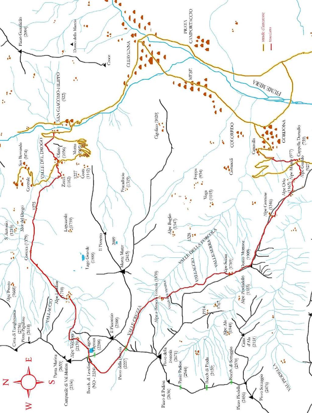
1 March 3rd, 2007 A circumnavigation around Il Pizzaccio (m 2588) March 3rd, Il Pizzaccio (mt 2588) stands strongly out the Forcola bivouac (mt 1838). The rifugio, always opened and unattended, was inaugurated on June 24th, Starting point Gordona, at the beginning of the road to Val Bodengo (mt 400). It's better to leave another car in S. Giacomo-Filippo to avoid the long crossing from Giacomo to Gordona at the end of the route. Synthetic route Gordona (m 400) Orlo (m 1165) - Cermine (m 1346) - Scima (m 1785) Bivacco Forcola (m 1838) Passo Forcola (m 2227) - passo di Lendine (m 2324) lago Caprara (m 2288) Alpe Valcapra (m 2164) - alpe Lendine (1710) Corseca Zecca (m 1162) Olmo (m 1056) S. Giacomo-Filippo (m 522) Gordona (mt 400) Orlo (mt 1165) - Cermine (mt 1346) - Scima (mt 1785) rifugio Forcola (mt 1838) passo Forcola (mt 2227) - passo di Lendine (mt 2324) Caprara lake (mt 2288) alpe Valcapra (mt 2164) - alpe Lendine (mt 1710) Corseca Zecca (mt 1162) Olmo (mt 1056) S. Giacomo-Filippo (mt 522) Route time Required equipment Difficulties / altitude gain Weather conditions found on March 3rd, 2007 Details Summary 15 hours. Suggestion: break the itinerary in 2 days by sleeping in rifugio Forcola. Boots and snow shoes suggested until spring time. 2/3 of 6, 1976 mt of up altitude gain. Snow over mt 1500 in valle della Forcola, until mt 1200 in valle del Drogo (N exposure). E: for the tracks Gordona Scima, rifugio Forcola - Passo Forcola, Lendine Olmo - S. Giacomo. EE: for the tracks Scima rifugio Forcola, Passo Forcola Passo di Lendine- Caprara lake Lendine. EE tracks have to be only done with snow well fixed or absent: very steep sides. 1
. Therefore turn left, cross the railway and keep on SP 40 (km 1.")

2 Il Pizzaccio and Punta della Forcola seen by the Lendine pass. At the center, beyond the crest, the Forcola pass. Car route: from Colico take SS 36 towards N up to S. Cassiano (km 22). Therefore turn left, cross the railway and keep on SP 40 (km 1.5), than go on SP 9 toward Gordona (km 2.5). At the crossing with the signal that indicates the gymnasium and Val Bodengo turn left. Pass via degli Emigranti and via Cimavilla, therefore, always on the main street, arrive to the small car park which precedes no thoroughfare on the road to Val Bodengo. The white Scima's bell tower. On the bell is written in relief the date

3 Itinerary A circumnavigation around the sharp peak of Il Pizzaccio, the highest point of the ridge that divides valle del Drogo (means Drogo Valley), is the opportunity to follow the ancient trails of the smugglers and to visit splendid jewels of alpine architecture such as Orlo, Cermine, Scima, Forcola, Lendine and Zecca. The starting point is Gordona, specifically Cimavilla, at the car parking that precedes the no thoroughfare on the road to Val Bodengo. The way goes along the asphalt until it crosses and follows the old muletrack that goes up on the mountain. After a steep slope, you get to the panoramic hill of the chapel Donadio (mt 759, h 0:50). Crossed the road, you gain altitude on the cobblestones, or the car way only where these are overlapped. Passed alpe Orlo (mt 1165, h 1:15), lookout-post over Valchiavenna, you shortly arrive to alpe Cermine (mt 1346, h 0:30). One small chapel, restructured in 1930 after the building of the muletrack, is the door to the graceful small village of Cermine, endpoint of the cobblestones track. Great is the landscape above lake of Novate and Pizzo di Prata. After the village, walking along the ridge, or leaning on the left side of this (weak track); you will reach Dosso The alpe Orlo chapel. Mottone (mt 1909). Beyond it you will find Scima and its beautiful white bell tower (mt 1785, h 1:30). Leaded by the signs painted on plants, the way goes into the woods of valle della Forcola. After a waved track, you can see the first white and red pylon of electricity line, approximatively located at the half slope of the valley's left side. The trace goes slightly higher than this pylon and decidedly lower than the next one, where avoids a rocky strip by getting Alpe Cermine. 3

4 down, then arrives to rifugio Forcola (mt 1838, h 1:15). The way gets lower heading toward N, then it climbs (W) the steep valley that ends to passo della Forcola (mt 2227, h 1). The path goes down in Swiss, therefore, at the end of the first shelf, it crosses in direction of the obvious Campanile di Val Marina (transl- bell tower of Val Marina - dir. ENE) and it raises the couloir on the left that culminates on the ridge without any cliff (Lendine pass, mt 2324, h 1). After the close Caprara lake, you slightly lose altitude toward N and, not going too far from the rock wall on the left, you pass thought the ruins of alpe Valcapra (mt 2164, h 0:20). You gain few meters of altitude until the head of a deep draining couloir. The marked path continues towards N-NE, in order to descend on the shoulder of the mountain that bends toward sunrise, but the shortest way comes down directly along the couloir until the plan where it is located alpe Lendine (mt 1710, h1). A wide muletrack thought the pines starts from the village and goes down along the valley. Passed Corseca (mt 1379), it continues (E) until Zecca (mt 1162), then it goes down along the grasses to Olmo (NE, mt 1056, h 2). Leaning to the trail: shorter than the car way, you loose fast altitude until you get to S. Giacomo - Filippo, term of itinerary (mt 522, h 1). From here is opportune to beg for a passage for Gordona! The section passo della Forcola - passo di Lendine. Passo di Lendine was the passage commonly used by the smugglers who were getting down in Switzerland from Drogo valley. The close depression of the ridge in SE direction, even if it is the shortest wayfrom passo della Forcola to Caprara lake, is a bad choice in case of snow. 4


5 The landscape from alpe della Forcola is great, both in west direction towards the hard pizzo della Forcola and Il Pizzaccio, both to east, where goes from the sour Pizzo di Prata to the sweet and multicoloured valley bottom. The way up seen from the San Cassiano village. 5
6 6
Excursions opposite Monviso
 Excursions opposite Monviso Idea, texts and photos: Gerard Muecke Briccas (or Trucchet) 2426m Ski Excursion MS Briccas Mount, seen from Crissolo, is an alluring destination a hill side like a billiard
Hiking in 3 Tuscan Parks. the hiking trail of the three parks
 Hiking in 3 Tuscan Parks the hiking trail of the three parks Hiking in 3 Tuscan Parks the hiking trail of the three parks This route will lead you through three different natural parks in the north of
Route #1) Mt. of the Holy Cross - North Ridge
 Mt. of the Holy Cross - North Ridge") Climbing 14ers can be very dangerous, please read the Mountaineering Safety Page and make sure you have a map+compass and can use them effectively, without the help of electronic devices. Route #1) Mt.
Climbing 14ers can be very dangerous, please read the Mountaineering Safety Page and make sure you have a map+compass and can use them effectively, without the help of electronic devices. Route #1) Mt.
The hike to 1100m altitude is recommended for experienced walkers.
 Cima Fopel This wonderful excursion takes place entirely within the Stelvio National Park in a particularly wild environment. The start is located near the Fopél Refection, on the road leading to the Passo
FROM GREECE TO ITALY, THE PEACE MESSAGE GOES ON The Mediterranean sea from the Abruzzo terraces walking onto bandits, hermits and shepherds footsteps
 Youth Mountaineering Trekking in Abruzzo (Italy) FROM GREECE TO ITALY, THE PEACE MESSAGE GOES ON The Mediterranean sea from the Abruzzo terraces walking onto bandits, hermits and shepherds footsteps Majella
IL BELLO DI ALAGNA 100% SUMMER. vecchi-besso.it
 IL BELLO DI ALAGNA 100% SUMMER vecchi-besso.it NATURE 50% ADVENTURE 50% ALAGNA 100% 50% NATURA 50% AVVENTURA 100% ALAGNA REGENERATING HOLIDAY ADVENTURE HOLIDAY VACANZA RIGENERANTE VACANZA AVVENTURA 50%
S2Kilimanjaro 8220 Barningham Road Richmond VA / /
 S2Kilimanjaro 8220 Barningham Road Richmond VA 23235 / 505.670.1441 Adventures @S2Mountaineering.com / www.s2mountaineering.com Lemosho Route The Lemosho Route is a remote, unspoiled and very beautiful
Family Hiking in the Dolomites. 8 Days
 Family Hiking in the Dolomites 8 Days Family Hiking in the Dolomites Traverse the breathtaking Dolomites, one of Europe's most magnificent mountain ranges, on this thrilling 8-day family adventure. Climb
Hiking Las Vegas.com
 Hike: Mt. Wilson via First Creek Canyon route Trailhead: First Creek marked Distance: 10 miles up and back Elevation gain: 3,400 feet Elevation of Peak: 7,070 feet Time: 7 to 9 hours (up and back) Difficulty:
Snowmobiling Madesimo Unique in the Alps and exclusively at HB-Adventure Switzerland
 Snowmobiling Madesimo Unique in the Alps and exclusively at HB-Adventure Switzerland Learn more about: - Locations & How to get there - Snowmobile Tours Snowmobile Information How to get There Driving
TUPPER DESIGNATED ACCESS ROUTE
 TUPPER DESIGNATED ACCESS ROUTE 1 FOR ACCESS/EGRESS TO CONNAUGHT, LOOKOUT, STONE ARCH, PORTAL PATHS AND TUPPER TRAVERSE EGRESS Length: 2.6km Vertical Gain: +162m / -83m (Values are for access. For egress,
ATACAMA CROSSING 2008 COURSE HANDBOOK STAGE 1. CP1 CP2 CP3 CP4 camp 2 Total Difficult Moderate Moderate km km 8.38 miles. 7.
 Camp 1: Rock Carvings Camp 2: Inca (On the edge of the slot canyons) 1: Navigation by Rock Altitude, rolling hills, flat out landscape. CP2 and Piedra de los cocas hieroglyphs Inca influence - side of
Dolomites Hutto-Hut Trek. 11 Days
 Dolomites Hutto-Hut Trek 11 Days Dolomites Hut-to-Hut Trek Set off for a spectacular journey across the Italian Dolomites, the magnificent range with Marmolada as its highest mountain, at an altitude of
Grizzly Peak A - East Ridge July 15, 2012
 Grizzly Peak A - East Ridge July 15, 2012 Difficulty: Difficult Class 2/Class 3 Upper Elevation: 13,995 feet Trailhead Elevation: 11,360 feet Elevation Gain: 3,000 feet Round-trip Length: 6.0 miles Trailhead:
Itinerary Overview. Sangre de Cristo Alpine Backpacking 22 days Ages Course Description
 Itinerary Overview Sangre de Cristo Alpine Backpacking 22 days Ages 16-18 Course Description Welcome, you re in for an experience of a lifetime! Imagine hiking through rolling forests, sharing alpine meadows
Bivouac Father Giancarlo Colombo 3485 m Col de la Mare SW ridge. Ortles-Cevedale Group Municipality of Pejo TN
 Bivouac Father Giancarlo Colombo 3485 m Col de la Mare SW ridge Ortles-Cevedale Group Municipality of Pejo TN Where the bivouac is located - Map Coordinates WGS84: (46.43,10.616) Contacts CAI Sezione Seregno
Machame 7 Days 6 Nights
 Machame 7 Days 6 Nights If Marangu is the Coca Cola route, then the Machame Route is the Whiskey route. It is the second most popular and one of the most scenic routes on the mountain. All climbers sleep
Lake Como Italian charm in the Alps, wonderful coloured villages alonga mountain lake TRIP NOTES 2017 Genius Loci Travel, All rights reserved.
 Lake Como Italian charm in the Alps, wonderful coloured villages alonga mountain lake TRIP NOTES 2017 Genius Loci Travel, 2017. All rights reserved. INTRODUCTION Lake Como is perhaps Italy s most spectacular
GLACIER STUDIES OF THE McCALL GLACIER, ALASKA
 GLACIER STUDIES OF THE McCALL GLACIER, ALASKA T John E. Sater* HE McCall Glacier is a long thin body of ice shaped roughly like a crescent. Its overall length is approximately 8 km. and its average width
Cinque Terre (Short Break) The best walks between coloured villages and terraced vineyards TRIP NOTES 2019 Genius Loci Travel. All rights reserved.
 The best walks between coloured villages and terraced vineyards TRIP NOTES 2019 Genius Loci Travel. All rights reserved.") Cinque Terre (Short Break) The best walks between coloured villages and terraced vineyards TRIP NOTES 2019 Genius Loci Travel. All rights reserved. INTRODUCTION The Cinque Terre gets its name from the
Cinque Terre (Short Break) The best walks between coloured villages and terraced vineyards TRIP NOTES 2019 Genius Loci Travel. All rights reserved. INTRODUCTION The Cinque Terre gets its name from the
COSTA BLANCA MOUNTAIN WALKERS - WALK DESCRIPTION. Visit for more walks descriptions in Spain
 Visit www.walksinspain.org for more walks descriptions in Spain Walk description originally prepared by:- Ralph Phipps Last Updated 15 th July 2016 Title of Walk Location of Start (include name of nearest
ANUMC Ski Mountaineering Expedition. Classic Haute Route ANUMC Expedition Fund Application By Andrew Gough
 ANUMC Ski Mountaineering Expedition Classic Haute Route 2010 ANUMC Expedition Fund Application By Andrew Gough Introduction: The Haute route (or High Mountaineers Route ) is one of the worlds most famous
The Best of the Cinque Terre
 The Best of the Cinque Terre Walking between coloured fishing villages and terraced vineyards TRIP NOTES 2019 Genius Loci Travel. All rights reserved. INTRODUCTION You walk through the extensive footpath
Lombardia. Run The Top. Guide and GPS.
 Lombardia Run The Top GRIGNE TRAIL Guide and GPS www.regione.lombardia.it LENGTH: 19 km ELEVATION RANGE: 1,900 m elev. gain TECHNICALITY: Partially equipped trail, both up and downhill. Not recommended
TREKKING. Claudio Pozzi, professional Alpine Guide
 TREKKING I can offer you some amazing excursions around the higher reaches of Lake Como, ranging from relatively easy half-day walks to more strenuous treks which take several days. You can admire the
The Cinque Terre & the Portofino Peninsula
 The Cinque Terre & the Portofino Peninsula Walking between coloured fishing villages and terraced vineyards 8-day walking tour with 3 different bases in charming hotels TRIP NOTES 2018 Genius Loci Travel,
Adventure Travel Trip Itinerary
 Adventure Travel Trip Itinerary Mt. Kilimanjaro & Mt. Meru Climbs, Tanzania July 8 23, 2017 Leader: Bill Blazek Date Activity (distances are approximate) Accommodation, Notes Meals 1 Saturday July 8, 2017
ride the wellness the wellness bike tour 21 st 28 th july 2018
 ride the wellness the wellness bike tour 21 st 28 th july 2018 RIDE THE WELLNESS. A wellness bike tour, from the 21st to the 28th of July 2018, to discover the highs of cycling, among the breathtaking
HEDONISTIC HIKING. The Italian Lakes - 8 Days. Lakes, Gardens and Majestic Mountains
 HEDONISTIC HIKING The Italian Lakes - 8 Days Lakes, Gardens and Majestic Mountains This tour explores three of the lakes of northern Italy: Lake Como, Lake Maggiore and the lesserknown Lake Orta. All three
Island Peak (Imja Tse )
") Popularly known as Imja Tse, Island Peak is the most climbing peaks in Nepal. It appears as an island of the icy sea while viewing form Dingbuche and on close inception, it exposes itself to be the most
Popularly known as Imja Tse, Island Peak is the most climbing peaks in Nepal. It appears as an island of the icy sea while viewing form Dingbuche and on close inception, it exposes itself to be the most
Mount Kilimanjaro Climbing via Rongai Route 8 day-itinerary
 Mount Kilimanjaro Climbing via Rongai Route 8 day-itinerary Total hiking distance: Approximately 70 kms The Rongai route ascends Kilimanjaro from the north-eastern side of the mountain, along the border
PERUVIAN ANDES ADVENTURES. TOCLLARAJU CLIMB or ISHINCA + TOCLLARAJU CLIMBING. Tocllaraju 4 Days Ishinca + Tocllaraju 5 or 6 days
 PERUVIAN ANDES ADVENTURES TOCLLARAJU CLIMB or ISHINCA + TOCLLARAJU CLIMBING Tocllaraju 4 Days Ishinca + Tocllaraju 5 or 6 days PEAKS Tocllaraju: 6034m (19797 ft) Grade: D / Hard / Some steep & technical
COMPLETE ITINERARY. History. road direct to the Stelvio s pass (built between 1817 and 1834) was
 was") COMPLETE ITINERARY History The oriental side of the Lake of Como has been interested since antiquity by a series of path that connected Milan with Alpine passes. Historical postcard: Varenna view from
COMPLETE ITINERARY History The oriental side of the Lake of Como has been interested since antiquity by a series of path that connected Milan with Alpine passes. Historical postcard: Varenna view from
17,985 Km 3:00-4:00 h 550 m 550 m
 maps.altarezia.eu Livigno, Giro delle Tee Parcheggio Pont de la Calcheira - Tea da Taglieda - Tea dal Plan - Tea da Rin - Tea dal Pel - Tea da Florin _ Tea da Borch _ Ponte Lungo - Tea da li Tea - Larix
Trek2Kili P.O. Box 2112 Moshi TZ Whatsapp
 Trek2Kili P.O. Box 2112 Moshi TZ Whatsapp +255 673 360 trek2kili@gmail.com MT. KILIMANJARO SHIRA 8 DAY 7 NIGHT TREK Very similar to Lemosho route, however it starts at 3,600 meters and is therefore not
Figure 1 Understanding Map Contours
 Figure 1 Understanding Map Contours The light brown lines overprinted on topographic maps are called contour lines. They indicate the elevation above sea level of land features and thus permit you to view
 www.guidealpinevaldizoldo.it We speak English. Wir sprechen Deutsch. Nos hablamos Español. +39 328 2170815 info@guidealpinevaldizoldo.it www.guidealpinevaldizoldo.it ski-telemark-snowboardmountaineering
ACTIVE PROGRAM 2018 SUNDAY
 ACTIVE PROGRAM 2018 SUNDAY 10.00 am - 12.00 pm Paneveggio Meeting point at the Visitor s Centre of the Natural Park Paneveggio, THE FOREST OF THE VIOLINS guided walk along the Naturalist Route and crossing
Weekly Program FiemmE-Motion Active & Nature
 Weekly Program FiemmE-Motion Active & Nature FROM JUNE 10TH TO SEPTEMBER 28TH 2018 BOOKING OF THE ACTIVITIES WITHIN 6.30 PM OF THE PREVIOUS DAY PHONE +39 331 9241567 FOR MORE INFORMATION VISIT WWW.VISITFIEMME.IT
Route #2) Mt. Massive - Southwest Slopes
 Mt. Massive - Southwest Slopes") Route #2) Mt. Massive - Southwest Slopes Difficulty: Class 2 Ski: Advanced, D6 / R2 / III Exposure: Summit Elevation: Trailhead Elevation: Elevation Gain: Round-trip Length: Trailhead: County Sheriff:
Route #2) Mt. Massive - Southwest Slopes Difficulty: Class 2 Ski: Advanced, D6 / R2 / III Exposure: Summit Elevation: Trailhead Elevation: Elevation Gain: Round-trip Length: Trailhead: County Sheriff:
Itinerary Overview. Maroon Bells Mountaineering 22-days. Course Description
 Itinerary Overview Maroon Bells Mountaineering 22-days Course Description Welcome, you re in for an experience of a lifetime! Imagine hiking through rolling forests, sharing alpine meadows with mountain
ODYSSEIA-IN AND ZIG ZAG HOLIDAYS TRAVEL TEAM SOFIA 1000, 20-V АL. STAMBOLIISKI, (ENTRANCE FROM LAVELE STR.) ТЕL: , FAX:
 ТЕL: , FAX:") High Mountain Traverses and Via Ferrata BULGARIA TRIP DOSSIER Focus: Strenuous Hiking and traverse Duration: 9 days Period: July 1 August 30 Trip Highlights: Traverse on the highest peak on the Balkans
High Mountain Traverses and Via Ferrata BULGARIA TRIP DOSSIER Focus: Strenuous Hiking and traverse Duration: 9 days Period: July 1 August 30 Trip Highlights: Traverse on the highest peak on the Balkans
(west) onto Charleston Boulevard. Drive 16 miles on Charleston and turn right into Red Rock
 onto Charleston Boulevard. Drive 16 miles on Charleston and turn right into Red Rock") Hike: North Peak and Ice Box Overlook up and back Trailhead: 2.5 miles up the Rocky Gap Road not mark Distance: 5 miles round trip Elevation gain: 2,694 feet Elevation Peak: 7,094 feet Time: 3 to 5 hours
Hike: North Peak and Ice Box Overlook up and back Trailhead: 2.5 miles up the Rocky Gap Road not mark Distance: 5 miles round trip Elevation gain: 2,694 feet Elevation Peak: 7,094 feet Time: 3 to 5 hours
REPORT. MANASLU EXPEDITION (8163 m) Track NE (traditional)
 Track NE (traditional)") REPORT MANASLU EXPEDITION (8163 m) Track NE (traditional) Contents Expedition passport 2 Description of the route 3 Description of the expedition 4-5 Scheme of the route 6 Map of the route 7 Map of the
REPORT MANASLU EXPEDITION (8163 m) Track NE (traditional) Contents Expedition passport 2 Description of the route 3 Description of the expedition 4-5 Scheme of the route 6 Map of the route 7 Map of the
Dolomites Hiking & Yoga Journey. 8 Days
 Dolomites Hiking & Yoga Journey 8 Days Dolomites Hiking & Yoga Journey Venture across the soaring Dolomites, adorned with sweeping valleys, dwarf mountain pines, alpine lakes, and storybook villages. Set
Mt. Gunnbjörn, Dome and Cone (IMG66)
") 2015 The Peaks of Greenland: Mt. Gunnbjörn, Dome and Cone (IMG66) Ski ascent of the highest peaks in the Greenland Arctic - Expedition manual - Content overview Expedition overview Further information
2015 The Peaks of Greenland: Mt. Gunnbjörn, Dome and Cone (IMG66) Ski ascent of the highest peaks in the Greenland Arctic - Expedition manual - Content overview Expedition overview Further information
Lake Garda as the one offered by Rifugio San Pietro, which is located at the south hillside. view out of an airplane. beautiful panorama.
 There is no better view of Lake Garda as the one offered by Rifugio San Pietro, which is located at the south hillside of the Monte Calino. Also a view out of an airplane cannot compete with this beautiful
The Mendip Way. Route Directions and Maps Uphill to Wells
 The Mendip Way Route Directions and Maps Uphill to Wells Website: www.mendiphillsaonb.org.uk Email: mendip@mendiphillsaonb.org.uk Facebook & Twitter: @MendipHillsAONB Phone: 01761462338 1 Uphill to Loxton
Oman Trek Trek the dramatic and beautiful scenery of Oman
 Oman Trek Trek the dramatic and beautiful scenery of Oman Discover Oman on this breath taking 5 day challenge. The mountain ranges and deserts of Oman offer spectacular trekking, and enables you to experience
VENICE TO ROME CYCLE ABOUT THE CHALLENGE ITALY CYCLE TOUGH
 ITALY CYCLE TOUGH ABOUT THE CHALLENGE Our exciting challenge takes us south on flat roads from the canals of Venice to the rolling hills of Tuscany and Umbria, passing terracotta-roofed towns and small
THE DOLOMITES. Are they stones or clouds? Are they real or a dream? Mount Lagazuoi is located in the heart of the Dolomites
 EXPO DOLOMITI 1 Are they stones or clouds? Are they real or a dream? Dino Buzzati, What are the Dolomites? THE DOLOMITES Mount Lagazuoi is located in the heart of the Dolomites ROOMS p. 6 M.I.C.E. p. 16
TOUR INFO GETTING THERE START CHARACTERISTICS VARIATIONS HISTORY ROADBOOK ALTITUDE
 TOUR INFO GETTING THERE START CHARACTERISTICS VARIATIONS HISTORY ALTITUDE TOUR INFO RIDING TIME Riding time at Riding time at Riding time at 14 Riding time at 16 Riding time at 18 Riding time at 20 % of
COLORADO TRAIN ADVENTURE
 COLORADO TRAIN ADVENTURE by Melody Hagerman at Travel the Horizon Summary Traveling by rail in Colorado is the most spectacular way to take in its unique scenery. From high above the tracks, you'll enjoy
Itinerary Overview. Sawatch Range Mountaineering Ages days
 Itinerary Overview Sawatch Range Mountaineering Ages 14-16 22 days Course Description Welcome, you re in for an experience of a lifetime! Imagine hiking through rolling forests, sharing alpine meadows
Photo Credit: Banff Lake Louise Tourism / Paul Zizka Photography MOUNTAIN ADVENTURES
 Photo Credit: Banff Lake Louise Tourism / Paul Zizka Photography MOUNTAIN ADVENTURES MOUNTAIN ADVENTURE PROGRAM Operated by Fairmont Chateau Lake Louise Fairmont Chateau Lake Louise has a long and proud
GRINDLEFORD GALLOP 2018
 GRINDLEFORD GALLOP 2018 Route Information The Grindleford Gallop follows a fixed 21 mile route through the lanes and paths of Derbyshire. All competitors must follow this route. An OS map of the area with
Italy - Switzerland - St. Moritz, Bernina and Como Lake Bike Tour 2018 Individual Self-Guided 8 days / 7 nights
 Italy - Switzerland - St. Moritz, Bernina and Como Lake Bike Tour 2018 Individual Self-Guided 8 days / 7 nights Pedaling among the wonderful alpine landscapes between the Province of Sondrio and the Grisons
HORSEBACK RIDING. All rates are subject to service charges
 HORSEBACK RIDING The Local Loop Ride - A family-friendly 45-minutes to one hour ride around Dunton s east property. Perfect for children and adults who are new to riding. Easy terrain and beautiful views.
MONTEROSA TOUR 7 days course along the border between Switzerland and Italy
 MONTEROSA TOUR 7 days course along the border between Switzerland and Italy We will start that wonderful tour from Zermatt - Switzerland. During the trip, we ll climb almost ten 4000m peaks located in
Cinque Terre & Portovenere
 Cinque Terre & Portovenere walking between coloured fishing villages and terraced vineyards TRIP NOTES 2018 Genius Loci Travel, 2018. All rights reserved. INTRODUCTION The Cinque Terre gets its name from
The Cinque Terre & Portofino Peninsula
 The Cinque Terre & Portofino Peninsula Walking between coloured fishing villages and terraced vineyards TRIP NOTES 2019 Genius Loci Travel. All rights reserved. INTRODUCTION Liguria is a beautiful coastal
MT KILIMANJARO TREK- LEMOSHO ROUTE
 #Trekking MT KILIMANJARO TREK- LEMOSHO ROUTE 10 Days 9 Nights Overview Take the challenging and less-travelled Lemosho route up to the highest peak in Africa, considered by many to be the most beautiful
Pontfadog. Walk A. Walk A
 Walk A A Bird s eye view of the village 2km. (1 1 /2 miles); height gain 45m. (150ft) about 45 minutes. Six minutes walk along the main road towards Glyn Ceiriog reach a signpost to Llwynmawr. Take the
THE ITINERARY DAY BY DAY SACRED WALKS DATES FOR 2019
 SACRED WALKS DATES FOR 2019 18th 26th May 1st 9th June 29th June 7th July 14th September 22nd September 28th September 6th October Min group size: 6 Max group size:12 The price per person is: 1590.00 Single
Itinerary 1 Valid for only 2016 AFRICAN ZOOM. Group Departures 2016 (Kilimanjaro Mountain hiking)
") AFRICAN ZOOM Group Departures 2016 (Kilimanjaro Mountain hiking) 1 LEMOSHO ROUTE Glaciers of Kilimanjaro 9 days Itinerary Plan Day 1 Arrive you are met and transferred to the lodge for overnight Outpost
AFRICAN ZOOM Group Departures 2016 (Kilimanjaro Mountain hiking) 1 LEMOSHO ROUTE Glaciers of Kilimanjaro 9 days Itinerary Plan Day 1 Arrive you are met and transferred to the lodge for overnight Outpost
Mount Daly a Most Prominent Peak via South Ridge
 Mount Daly a Most Prominent Peak via South Ridge Difficulty: Class 3 Exposure: Exposed in places along the ridge Summit Elevation: 13,305 Elevation Gain: 4100 from trailhead; 1800 from Capitol Lake camp
France Coastal Corsica Hiking Tour 2019 Individual Self-Guided 8 days/7 nights
 France Coastal Corsica Hiking Tour 2019 Individual Self-Guided 8 days/7 nights The sun sparkles over the deep blue sea and allows the cliffs to gleam in soft pink. In the back the high peaks of Corsica
KANG YATSE-II KANG YATSE-II TREK Jul 23 - Aug 04 &Aug 15-27, 2019
 KANG YATSE-II KANG YATSE-II TREK Jul 23 - Aug 04 &Aug 15-27, 2019 KANG YATSE-II: INTRODUCTION The Western Summit of the Kang Yatse Peak, or Kang Yatse II, offers the perfect challenge for folks looking
L U N C H C R E E K T R A I L GLACIER NATIONAL PARK
 D I R T I N M Y S H O E S L U N C H C R E E K T R A I L GLACIER NATIONAL PARK Lunch Creek "Secret" Hike This short hike on the Lunch Creek Trail will knock your socks off! It's the perfect mix of length,
A Tour of the Valle del Gizio
 Walk 25 A Tour of the Valle del Gizio Walking time 5hrs 30mins (4hrs if Colle Mitra is omitted) Difficulty 2 (likely to be snowbound in winter months); 1 (if Colle Mitra is omitted) Ascent/descent 570m/570m
Itinerary Overview. Continental Divide Alpine Backpacking 22 days Ages Course Description
 Itinerary Overview Continental Divide Alpine Backpacking 22 days Ages 16-18 Course Description Welcome, you re in for an experience of a lifetime! Imagine hiking through rolling forests, sharing alpine
3 days for trekking the Etna nature and culture
 3 days for trekking the Etna nature and culture Description The 3 days trekking on Etna include 3 hiking on the volcano, starting from Ragalna Centre of Local Culture, a little village on the Etna mountain
Ystwyth and Rheidol Bridleway Routes. Route 2:Llanilar Circular
 Ystwyth and Rheidol Bridleway Routes Route 2:Llanilar Circular Route overview and terrain: A long circle using connecting ridges with fine views to link the Rheidol and Ystwyth river valleys. The route
Prepared for Prepared on Travel Agent Revised on
 Trip Title Prepared for Prepared on Travel Agent Revised on Aconcagua Adventure CONTACTS Adventure International, LLC P.O. Box 2621 Venice, CA 90294 USA Telephone: 888.664.3865 Fax: 516.977.8617 Email:
Epic Family Adventure in the Austrian Alps. 9 Days
 Epic Family Adventure in the Austrian Alps 9 Days Epic Family Adventure in the Austrian Alps On this extraordinary family adventure through Germany, Austria and Italy, cross the mighty Alps on one of Europe's
The Cleo s Bath North Side Hike
 The Cleo s Bath North Side Hike This hike is a cross-country hike from Pinecrest Lake to the north side of Cleo s Bath. It is quieter and much less crowded than the normal route, which goes up the south
Pisa, Lucca, Cinque Terre & Portovenere
 Pisa, Lucca, Cinque Terre & Portovenere walking & sightseeing between Tuscany & Liguria TRIP NOTES 2018 Genius Loci Travel, 2018. All rights reserved. INTRODUCTION This tour starts from the famous city
Victoria Falls Lookout to Blue Gum Forest
 Victoria Falls Lookout to Blue Gum Forest 8 hrs Experienced only 13.8 km One way 5 112m This long day-walk follows a remote track down from Victoria Falls lookout, passing the waterfall, and into the Grose
Paestum, Monte Stella & Cilento Coast
 Paestum, Monte Stella & Cilento Coast Walking along the beautiful Coast of the Sirens TRIP NOTES 2018 Genius Loci Travel, 2018. All rights reserved. INTRODUCTION The region of Campania marks the real starting
Langtang Trek (Central Himalayan s)
") (Central Himalayan s) This trek gives you the opportunity to get right in among the Himalayan peaks. It offers an exceptional diversity of scenery and culture. The combination of two treks gives great
(Central Himalayan s) This trek gives you the opportunity to get right in among the Himalayan peaks. It offers an exceptional diversity of scenery and culture. The combination of two treks gives great
MT TUTOKO GUIDED ASCENT
 MT TUTOKO GUIDED ASCENT 2018/2019 TRIP NOTES Mount Tutoko Trip Notes All material Copyright Adventure Consultants Ltd 2018/19 Mount Tutoko (2,746m) is the highest peak in the Darran Mountains, located
Italy - Walking in Pisa, Lucca, Cinque Terre & Portovenere
 Italy - Walking in Pisa, Lucca, Cinque Terre & Portovenere 8 day walking holiday in Tuscany and Liguria with overnight stays at three charming hotels in respectively Pisa, Levanto and Portovenere. The
Mountain Goats and Winter Recreation November 17, 2011
 Mountain Goats and Winter Recreation November 17, 2011 Summary Mountain goats need protection from disruption and displacement in their winter feeding areas by motorized and non-motorized recreationists
TREK THE ROCKIES ABOUT THE CHALLENGE TREK THE ROCKIES FOR HIGHLAND HOSPICE CANADA TREK DEMANDING
 TREK THE ROCKIES CANADA TREK DEMANDING ABOUT THE CHALLENGE The Canadian Rockies are justifiably world-famous for their magnificent scenery: the combination of impressive, jagged mountains, bright turquoise
Camping Arolla. Little guide for our hiking and mountaineering guests. First english edition 2016 Camping Arolla Sàrl
 Camping Arolla Little guide for our hiking and mountaineering guests First english edition 2016 Camping Arolla Sàrl Impression This guide can be printed on the A4 format. In order to have well readable
EXPLORA PATAGONIA Explora, Art of Travel - Tour Extension
 EXPLORA PATAGONIA Explora, Art of Travel - Tour Extension 9 DAYS / 8 NIGHTS Spend 8 days surrounded by enchanting valleys, exotic fauna and mighty mountains reflecting in the crystal-clear lakes at the
MANCA 2015 LAND CRUISE MOROCCO HIGH ATLAS MOUNTAINS
 MANCA 2015 LAND CRUISE MOROCCO HIGH ATLAS MOUNTAINS The overnight train from Tangier to Marrakech on a full June moon is a magical ride. In the early morning, as she approached Marrakech the morning fog
Mt. Elbert East Ridge
 Mt. Elbert East Ridge Difficulty: Class 1 Exposure: None Summit Elev.: 14,440 feet Trailhead Elev.: 10,400 feet Elevation Gain: 4,100 feet Roundtrip Length: 8.5 miles Trailhead: South Elbert (near Twin
Itinerary Overview. Colorado San Juan Mountaineering 15-days
 Itinerary Overview Colorado San Juan Mountaineering 15-days Course Description Welcome, you re in for an experience of a lifetime! Imagine hiking through rolling forests, sharing alpine meadows with mountain
SECONDARY NETWORK of trails in the Teide National Park
 SECONDARY NETWORK of trails in the Teide National Park 22. Lomo Hurtado Start: Trail No. 1 in the Llano area of Los Rastrojos End: Trail No. 6 in the Los Conejos Mountain area Length: 4.8 km Elevation:
CARCASSONNE TO BARCELONA CYCLE
 FRANCE, SPAIN CYCLE TOUGH ABOUT THE CHALLENGE This challenging, spectacular ride takes us from the beautiful fortified city of Carcassonne, through the rolling hills of Cathar country before reaching the
The height of Machu is 6630m on the Swiss map, 6612m on the Russian map and 6603m on Google Earth.
 Hispar Expedition 2017 Expedition Final Report MEF reference: 17-42 Country and region visited: Pakistan, Hunza Valley, Karakoram. Objective To make the first ascent of Machu (6630m) by the southwest and
Mt. Rainier Three-Day Muir Climb
 Mt. Rainier Three-Day Muir Climb Details below provided by AAI Elevation: 14,411 feet Guide Service: Alpine Ascents International (AAI) Fundraising minimum: $5,000.00 USD Muir Three-Day Overview Our three-day
Scenic Swiss Alps by Rail The Grand Train Tour of Switzerland
 SwissVistas.com Scenic Swiss Alps by Rail The Grand Train Tour of Switzerland TOUR SWITZERLAND BY RAIL IN LEGENDARY TRAINS Activity Level Our Adventures are designed for people who are energetic, active,
ACTIVITIES AT A REDUCED PRICE FOR THE GUESTS OF SPORT & OUTDOOR ACCOMMODATION FACILITIES VAL DI FASSA - SUMMER 2016
 ACTIVITIES AT A REDUCED PRICE FOR THE GUESTS OF SPORT & OUTDOOR ACCOMMODATION FACILITIES VAL DI FASSA - SUMMER 2016 WEEKLY PROGRAMME Info : info@fassasport.com www.fassasport.com Monday - MTB TEST TOUR
Adventure Travel Trip Itinerary
 s of trip: August 20 - September 4, 2019 Aug 20 (Tues) Travel to Geneva, Switzerland 1 Aug 21 (Wed) Arrival in Geneva Please plan to arrive before 2 p.m. local time, to allow enough time to get through
Morning Star Peak Avalanche Accident
 Morning Star Peak Avalanche Accident Saturday, December 4, 2010 Date: 2010-12-13 Submitted by: Oyvind Henningsen Everett Mountain Rescue and Mark Moore NWAC Place: Morning Star Peak, north-central WA Cascades
TREKKING IN THE ALPS HILARY SHARP SUMMER HIKING AND WINTER SNOWSHOEING
 TREKKING IN THE ALPS HILARY SHARP SUMMER HIKING AND WINTER SNOWSHOEING www.trekkinginthealps.com info@trekkinginthealps.com NO hidden costs. Small groups guaranteed. Expert guiding All levels catered for.
Leg 2 Cortemilia Bergolo
 Leg 2 Cortemilia Bergolo 27 GTL - Grande Traversata delle Langhe Leg 2 Cortemilia Bergolo 28 Leg 2 Cortemilia Bergolo An uphill section starting in Cortemilia and the surrounding hazelnut groves and finishing
Los Torres del Paine in the Chilean Patagonia
 Total Trekking: 95km (65 miles) Los Torres del Paine in the Chilean Patagonia Rick Crandall November 19 26, 2011 Torres del Paine is a mountain massif that is a national park of Chile, near the southern