BENEFICIARY EDITOR. exofen:layout 1 3/21/08 12:29 PM 1
|
|
|
- Joseph Baldwin
- 5 years ago
- Views:
Transcription
1 exofen:layout 1 3/21/08 12:29 PM 1 Texts (in Greek): Katerina Boli, Eleftheria Theodoroudi Translation into English: Maria Anagnostopoulou Translation into Bulgarian: Glossima-Vehrheim Editors: Maria Katsakiori, Katerina Boli Map: Lena Hatziiordanou, Antonis Apostolakis Photos: Photographic archive of ΕΚΒΥ/Eghromon, Maria Katsakiori, Katerina Boli Rhodope lily photo: Kostas Vidakis Brown bear photo: Sotiris Milionis Lay out: Art Makers Printing: D. Altintzis March 2008 The traveller s guide to Rhodope mountain range was produced in the framework of the project Common approaches to a joint planning for the promotion of the ecologically sensitive sites on the Rhodope Mountain of the Community Initiative Operational Programme INTERREG IIIA/PHARE CBC GREECE-BULGARIA of the Ministry of Economics and Finance, co-financed by the European Regional Development Fund (75%) and by national resources (25%). BENEFICIARY EDITOR
2 exofen:layout 1 3/21/08 12:29 PM 2
3 exofen:layout 1 3/21/08 12:29 PM 3
4 exofen:layout 1 3/21/08 12:29 PM 4

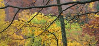
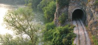
5 22x22eng:rodopi22x22 3/21/08 1:01 PM 1 A natural boundary between Greece and Bulgaria, Rhodope spreads over a surface area of approximately 19,000 km2 (82% in Bulgarian and 18% in Greek territory), signalizing a precious ecosystem of the Balkans, a mountain range of enormous ecological significance. At the north of the Prefectures of Drama and Xanthi, from mount Falakron to the Pomac villages of Xanthi, and from the Hellenic-Bulgarian borders till the area of Stavroupolis and Paranesti, the western and central parts of the Rhodope mountain range have the privilege to host the richest forests in Greece and some of the least disturbed natural ecosystems of Europe, while they provide shelter to animals which are threatened by extinction, such as the brown bear and the chamois. The area is characterized by a multifarious relief with innumerable peaks, meandering streams and tributaries of the river Nestos, densely vegetated gorges and impressive waterfalls. It is a thinly populated area, however rich in deserted villages, water mills, arched bridges, castles and other archaeological ruins.
, its geology and geomorphology, in addition to the fact that the area was not")
6 22x22eng:rodopi22x22 3/21/08 1:01 PM 2 Central and Western Rhodope The mountain range of Western and Central Rhodope is one of the most interesting areas in Europe, thanks to its great biodiversity. This is the result of its geographical position (a meeting point for the Balkan, Irano-caspian and Mediterranean flora), its geology and geomorphology, in addition to the fact that the area was not affected by the glaciers. Thereby, for several species of central and northern Europe, Rhodope provides shelter and delimits their southernmost occurrence.

7 22x22eng:rodopi22x22 3/21/08 1:01 PM 3 > Central and Western Rhodope Despite its relatively small surface area, the Greek part of the range has a high ecological interest, as it hosts variable ecosystems and vegetation zones, from the purely Mediterranean ones, to that of the boreal conifers of northern Europe and the proalpine zone of meso-europe. The Bulgarian part is equivalent; its conifer forests represent 70% of the total vegetation of Rhodope and its western part hosts the best-preserved European black pine forests of Bulgaria, as well as well preserved mountainous grasslands. On the Greek side, 5 sites have been included in the NATURA 2000 Network, 1 of them is designated Natural Monument on the basis of national legislation and Biogenetic Reserve and another is also nominated as Biogenetic Reserve by the Council of Europe. Since 1941, when the first protected area was established, Bulgaria has declared 216 protected areas until 2006.


, which often creates mixed stands with fir and Norway spruce, but also with maple, aspen, birch, European black pine and Scotch pine.")
8 22x22eng:rodopi22x22 3/21/08 1:01 PM 4 Travelling along less than 100 km, from the coast to the highest peak of the Rhodope mountain range, you will observe all vegetation zones, from the Mediterranean to a similar to the boreal conifer zone, a unique experience in the entire Mediterranean. > vegetation Exploring vegetation First you will cross the Mediterranean zone of evergreen broadleaves with strawberry trees, wild olive trees, kermes oak, ash tree, Judas tree, etc. Up the slope you will enter the transitional zone of the kermes oak, and moving on even higher, you will find yourself in the zone of oak forests, the most important of Rhodope, cardinal species being the Hungarian oak, the sessile oak and the downy oak. In the same zone, there are lime wood trees and European black pine stands, either non-mixed or mixed with oak. Further above, you will enter the continental zone (beech zone), which often creates mixed stands with fir and Norway spruce, but also with maple, aspen, birch, European black pine and Scotch pine. One of the most beautiful mixed forests of beech with fir and Norway spruce is the virgin forest of Frakto. The highest vegetation zone you will meet there, is the, unique in Greece, zone of boreal conifers, with forests of Scotch pine, Norway spruce and birch, which compose real proalpine or Scandinavian landscapes. A distinct category of vegetation, which does not follow the rules of species altitudinal succession as it does not depend on climate but rather on water, is that of the riparian forests, with willows, white poplars, common alders and oriental planes. You will meet those along the river Nestos and the local gullies and streams.


,")
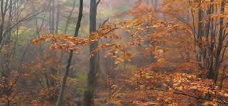
9 22x22eng:rodopi22x22 3/21/08 1:01 PM 5 On the Rhodope, the beech grows over the best quality soils and on the most humid north and east-facing slopes. Uniformly grown or mixed with other species, it creates most productive forests of great ecological, economic and aesthetic value, which moreover contribute to the generation of pure drinking water. The kermes oak, a natural protection against soil erosion and highly demanded goat food, supported the economy of Rhodope and the entire country as a source of energy for heating, the operation of limekilns and furnaces and the distillation of raki. Currently, kermes oak forests are only present on Crete. In the rest of Greece, the kermes oak mostly occurs in the form of a shrub. 44% of the forests in Greece are oak forests. It was therefore not accidental that the oak was consecrated to Jupiter, became the sacred tree of Macedonian kings, and acquired the power to vaticinate. Oak wood was used as fuel, and as raw material in naval architecture, furniture making and fencing. Its acorns became food for pigs, goats, wild animals but also people, who, during the German occupation (2nd World War), survived by making bread out of acorn flour. The dominant species on Rhodope, but also in the entire country, is the Hungarian oak, a species of outstanding value, due to the extent of its ecosystems (80% of the total oak forests), but also because of the much sought, light-coloured wood.


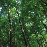
10 22x22eng:rodopi22x22 3/21/08 1:01 PM 6 Discovering the natural treasures The Simida (birch) Forest > forest A virtually boreal species, the birch, with its characteristic white bark and the delicate, tremulous leaves, creates extensive non-mixed forests in proalpine areas in Scandinavia and in Russia. In Greece, it sporadically appears in beech, Scotch pine or Macedonian pine and Norway spruce forests. The forest that it forms in the northern part of the Prefecture of Drama is unique in the whole of Greece and the southernmost in Europe. Its ecological significance is great, due to its great biodiversity, matching its aesthetic value, as it is one of the most beautiful forests in the country.


11 22x22eng:rodopi22x22 3/21/08 1:01 PM 7 The Virgin Forest of Frakto The area of Frakto hosts one of the most beautiful mixed forests of beech with fir and Norway spruce, as well as one of the least disturbed natural forest ecosystems in Europe, with vast ecological interest. The Virgin Forest lies in the north eastern corner of the Prefecture of Drama, beneath the highest peak of Central Rhodope, at 1,953 m. In 1979, its phytogeographical and ecological value was acknowledged and in 1980, it was designated as a Natural Monument. Ever since, it enjoys an absolute protection status and entrance is only allowed for scientific purposes. Nevertheless the peripheral zone of the forest, which accommodates the Forest Worksite of Frakto, is open to the public. Visitors can arrange an overnight stay, by contacting the Forest Service of Drama. At the Visitor Centre of Frakto the traveller can take all necessary information to organize a tour about the forest, following forest roads and marked paths.
. Its highest peak is Gyftokastro (1,827 m). On Haidou, beech forests dominate, mixing with Scotch pine, birch and Macedonian pine.")

12 22x22eng:rodopi22x22 3/21/08 1:01 PM 8 The Beech Forest in Tsihla, Haidou Haidou, on the mountains of the Prefecture of Xanthi, is in fact the southern part of mount Koula (its northern part pertaining to Bulgaria). Its highest peak is Gyftokastro (1,827 m). On Haidou, beech forests dominate, mixing with Scotch pine, birch and Macedonian pine. At higher altitudes you can see grasslands, remnants of aestival pastures. The Beech Forest, around 12 km from the Forest Village of Erymanthos, is situated at the location Tsihla, at 1,500 m and occupies approximately 18 hectares. It has been designated as a Natural Monument due to its undisturbed beech stands and its ecological, botanical and aesthetic value. The Elatia Forest At the northern corner of the Prefecture of Drama, along the Greek-Bulgarian borderline, in the area of Elatia, you will come across the Norway spruce forest, unique in the country. Your visit will imprint in your memory, as the aspect of the forest landscape leads you directly to those of northern Europe. In this impressive piece of nature you will identify all forms of Norway spruce existing in Europe, such as that of Sudety (West Czech Republic) with the pendulous branches, but also wild flowers, endemic of the Balkans and rare in Greece. In the same area, you may visit the Forest Village of Elatia, the local administrative and operational centre, at a distance of 72 km from Drama. At the village you may enjoy the accommodation facilities or take one of the opportunities for interesting organized tours starting there.


13 22x22eng:rodopi22x22 3/21/08 1:01 PM 9 The wild flowers of Rhodope Across the mountain range of Rhodope, 834 species and 287 subspecies of plants have been recorded. These include 7 endemics of Rhodope, 10 Greek endemics, around 150 endemics of the Balkan Peninsula, 59 protected species and 82 species registered as rare in Greece. The most reputed wild flower of Rhodope is its lily. Exquisite, with bright yellow colour, the Rhodope lily (Lilium rhodopaeum) was originally recorded in 1951 at the Bulgarian side of the mountain range, in sub alpine grasslands, which host the largest population of the species. In Greece, it occurs sporadically, over 1,600 m. It is protected by the Bern Convention, by the national legislation of Greece and Bulgaria, and is included in the Red Data Book of rare and threatened plants of Greece. Look for it and admire its beauty in summer, at the edge of beech and Norway spruce forests, in open spaces in between them, in the sub-alpine grasslands of Frakto, but also near the settlement of Leivaditis, where the species has been reported to occur. > wild flowers


14 22x22eng:rodopi22x22 3/21/08 1:01 PM 10 Tracking the animals The large mammals that find refuge in the forests of Rhodope, the 139 bird species, amphibians, reptiles, but also the fish species living in the streams of the area, qualify this mountain massif as highly important for the fauna. Footprints on the ground, sounds and wingbeats will point toward the presence of the animals. For the capercaillie and the hazel grouse, the Virgin Forest of Frakto constitutes the one and only nesting site in Greece. > animals The most remarkable mammal of the area is the brown bear, a priority species at European level. Its population is estimated at around individuals. In the rich beech forests, particularly in older trees, 8 out the 10 woodpecker species recorded in Greece find refuge. On the steep slopes of Frakto, you may see the chamois, with a population that does not exceed individuals. The habitats of major importance to amphibians are the high-altitude grasslands of Rhodope which are crossed by streams and gullies. In the waters of Vathyrema and Stravorema, there are populations of the wild trout, which present a particular interest as a gene pool.


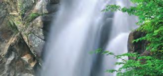
15 22x22eng:rodopi22x22 3/21/08 1:01 PM 11 Following the water The River Nestos A natural borderline between Macedonia and Thrace, the river Nestos emanates from mount Rila of Bulgaria and discharges into the Thracian sea, after a total course of 234 km. Crossing the Hellenic-Bulgarian frontier, it traverses the mountain range of Rhodope, it reaches Paranesti and flows on till the town of Stavroupolis, where it enters its gorge, which has been designated as an Aesthetic forest. The gorge of river Nestos spreads over 2,380 hectares up to the town of Toxotes, creating an environment of outstanding beauty. Further south, from the bridge of Toxotes towards the coastal zone opposite the island of Thassos, the river forms an extensive delta of 55,000 hectares, which is a wetland of international importance (Ramsar site) surrounded by a riparian forest, unique in Greece for its size and among the most beautiful Europe-wide. and the obstructios The only obstructions along the flow of river Nestos are the dams. Those of Platanovrysi and Thisavros. Constructed for power generation and irrigation water storage, they have modified the bank structure and the water flow pattern and compose an admittedly imposing landscape. > water


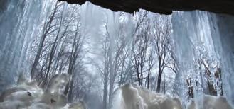
16 22x22eng:rodopi22x22 3/21/08 1:01 PM 12 The streams Along its course, river Nestos collects the waters of numerous streams, forming a manifold hydrographic network with a noteworthy fish fauna and plentiful riparian vegetation. Wandering about the mountain massif, you will come up against tributaries of the river Nestos, with streams of variable size; Arkoudorema, Diavolorema, Stravorema, Megalo Rema, but also river Kosynthos. You will see their junctions and their arched bridges, you will become spellbound by the magic of the waters and you will be overwhelmed by their waterfalls. and the waterfalls of Ahladorema The stream Ahladorema forms 5 waterfalls in the Frakto forest. The first one, a cascade of no more than 7 m. The second one, more impressive, 13 m in height. With the water dashing down from a height of 70 m, the third waterfall at the edge of the Virgin Forest, is magnificent to watch, though only visible from the opposite slope (the other two cascades are seasonal and hard to access).


17 22x22eng:rodopi22x22 3/21/08 1:01 PM 13 If you wish to visit them, you must enter the peripheral zone of Frakto and walk to the near Forest Worksite, where you will be supplied with useful information by the guards, and by the Visitor Centre. Going on, you will see the sign-posted crossway which guides the tour about the forest. For the access to the waterfalls, you will have to choose between two options: you may either take the organized path which starts a few meters further and ends up at the waterfalls after a trek of 3 km, or continue on the forest dirt road that will lead you to another path, only 300 m far from the first waterfall. Walking until the first cascade is undemanding. Keeping on the same path, and passing through a dense beech forest, you will arrive at the second cascade. Accessing the third waterfall is more laborious, as you will have to cross steep moraines. > water


.")
 and taking the asphalt road leading to the Forest Village of Erymanthos (see trail 4), you will be presented with a double option, as two tracks start at that")
18 22x22eng:rodopi22x22 3/21/08 1:01 PM 14 Trahonio (Leivaditis) With its waters violently rushing down from a height of approximately 40 m, it reasonably claims the reputation of the most impressive waterfall on Rhodope. At the verge of the Prefectures of Drama and Xanthi, no matter if you reach it via Paranesti or via Stavroupolis, whether you remember it as the Waterfall of Trahonio or the Waterfall of Leivaditis, it will undoubtedly enchant you. If you start your tour from the Prefecture of Xanthi, you might either opt for the trail Lykodromio-Kallithea (on the secondary road from Xanthi to Drama), which will easily take you, after a drive of about 30 km, to the Forest Village of Erymanthos, and further on to the waterfall, or, alternatively, for the equally beautiful trail Stavroupolis-Daphnonas- Ano Karyofyto-Leivaditis (22 km). A small deviation at Kato Karyofyto, in order to visit the traditional water mill and the stone bridge, is worth the time. Arriving at Leivaditis, (at 1,220 m) and taking the asphalt road leading to the Forest Village of Erymanthos (see trail 4), you will be presented with a double option, as two tracks start at that point. The first one, called Tilemahos Samouridis is 2 1/2 hours long (200 m from the settlement) and a shorter one, to which you will be led by the dirt road you will take, around 4.5 km after Leivaditis. Constantly meandering, the path will take you to the waterfall after a trek of 2,000 m. Those of you who wish to start from the Prefecture of Drama, you may set off from Paranesti and take the direction to Trahoni, following the road network (around 27 km in total).

 from the waterfall of Trahoni.")
19 22x22eng:rodopi22x22 3/21/08 1:01 PM 15 This trail goes along the stream Arkoudorema through dense oak forests. Passing, successively, from the crossways of Ano Tholos and of the Dam of Platanovrysi, of Silli and of Prasinada, it reaches the rather small, but still impressive waterfall of Agia Varvara and moves on to the sign-posted junction with the dirt road (7 km) which will lead you to the deserted settlement of Trahonio. There from, another 7 km along the forest dirt road will bring you at a hairbreadth (300 m) from the waterfall of Trahoni. You will have to leave your car there and effortlessly walk on the path, overgrown with beech, maple, ash and lime wood trees. > water Lepidas Approximately 35 m in height, it is the most voluminous waterfall created by the stream Tsoukali, within the forest of Lepidas. You may access it following the road from Paranesti to Dipotama (about 21 km), in whose vicinity, one of the largest stone bridges of Eastern Macedonia brings together the banks of the stream Arkoudorema. From the settlement of Dipotama, you should take the well-maintained gravelled road leading to the forest of Lepidas. After a drive of 7 km with a panoramic view of Rhodope, you see the starting point of the trail that will lead you to the base of the waterfall. The trail is rather short (700 m), smoothly descending with continuous zigzags through dense vegetation with beech and oak trees, whereas at the lower parts, maple, elm and lime wood trees. On your way back from the waterfall, keep on the same trail, to end up at Megalo Livadi. You will have the chance to contemplate the view of the mountains of Rhodope and the valley of Arkoudorema, from the viewpoint of the Forest Worksite of Lepidas, and discover the impressive, though hard to access, waterfall of the stream Skoteino rema. Megalo Livadi, located at 1,500 m, will bewitch you with its wild flowers and the Scotch pine stands growing around its valley. From there on, you may reach the bog of the area, inexhaustible source of information on the evolution of the vegetation, and return via the forest road heading south, only to end up at the Forest Worksite of Lepidas, having completed a circular course.

 of the 2nd century B.C.")
 of the 2nd - 3rd century A.D.")


20 22x22eng:rodopi22x22 3/21/08 1:01 PM 16 On the trails of culture > culture Traditional settlements, archaeological monuments, water mills and innumerable stone bridges, traditions and customs dating back to centuries, enhance the significance of Rhodope and complement the cultural capital of the plain parts of the Prefectures of Drama and Xanthi. The Macedonian Tomb at Komnina (on the road from Komnina to Dafnonas) of the 2nd century B.C., the Castle of Kalyva (4 km from the homonymous settlement), probably built by Philip II to ensure control over the wider area of the River Nestos and the Relief of Mithras Tavroktonos (Mithras the Bull-Slayer) of the 2nd - 3rd century A.D. (southeast of Thermes), will reveal to you the wealth hiding in the heart of Rhodope. The stone arched bridges bringing together the stream banks, more than a hundred in number, will expose before your eyes, communication paths among the settlements, lost in time. The traditional water mills, such as those of Kato Karyofyto and of Halil in the area of Oreo, will remind you the power of water. The Reunions of the Sarakatsani at the Forest Village of Elatia and Erymanthos, will initiate you to the way of life of those nomad stock-breeders who lived there in ancient times. Paranesti and Stavroupolis will open for you the gate to the mountain massif. The Natural History Museum in Paranesti will inform you on the na tural assets of Rhodope, while the Folk Museum of Stavroupolis will introduce you to the traditional lifestyle. Settlements such as Potamoi, Skaloti, Dipotama, Trahoni, Leivaditis, Sminthi, Ehinos, will give you plentiful options for a number of tours around Rhodope. The countless deserted mountain villages of Drama will enchant you, while the Pomac villages of the mountainous part of Xanthi, will reveal to you a living residential complex of outstanding architectural and cultural value.
, Volakas and the ski centre")


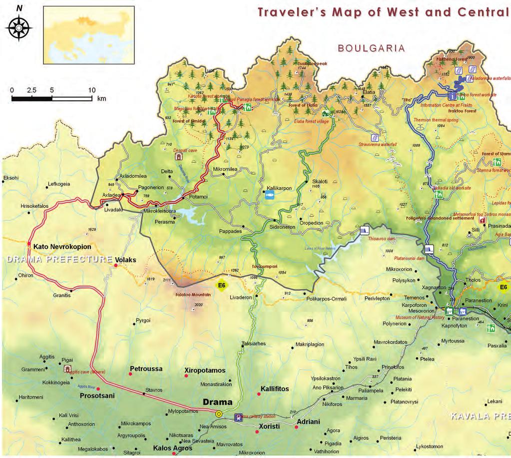
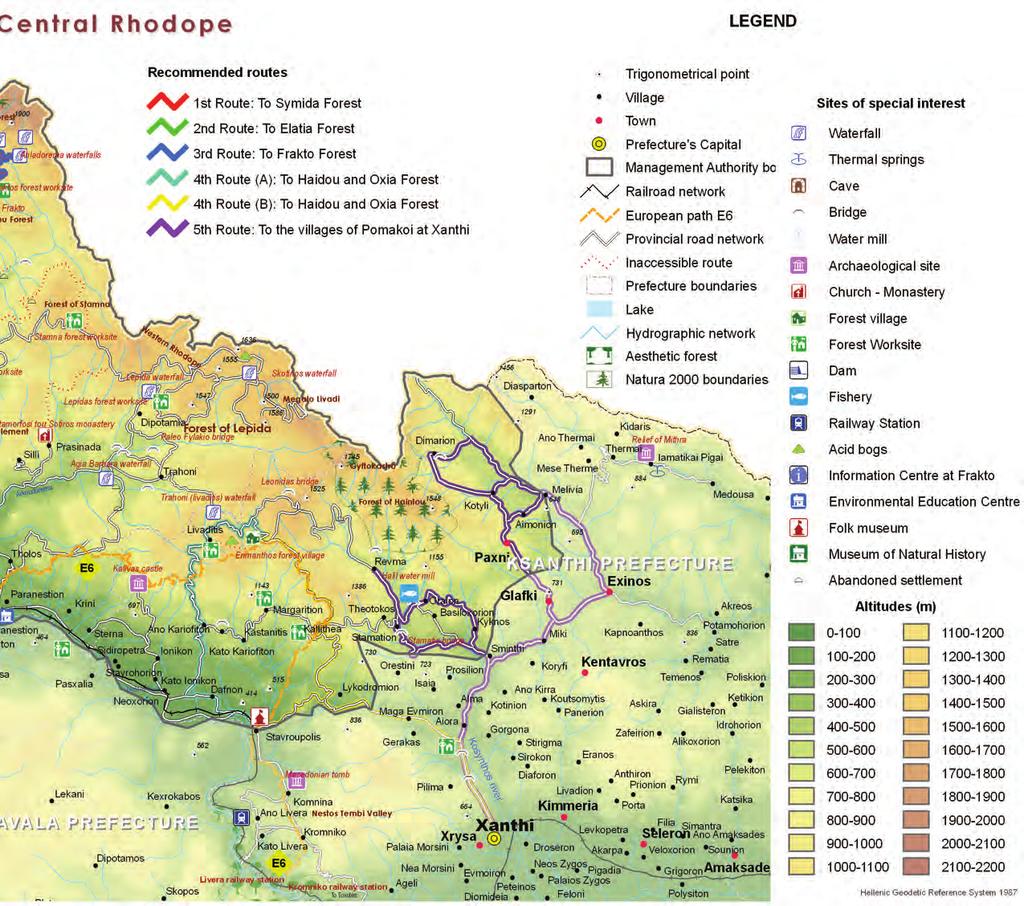
21 22x22eng:rodopi22x22 3/21/08 1:01 PM 17 1 st trail: towards the Simida (birch) Forest Setting off from Drama, you may take the road from Drama to Exohi, in order to drive to Kato Nevrokopi. It is worthwhile to deviate from the main road and visit the cave of the Aggitis river sources, the Hellenistic Sanctuary of Dionysus (near the settlement of Kali Vrisi), Volakas and the ski centre of Falakron, the settlement of Granitis, the fort of Lisse, a rampart of Metaxa bunkers and a monument of the Hellenic contemporary history. After K. Nevrokopi, the trail heads eastwards, following the secondary road network with the direction to Potamoi and Mikromilia. After Leivadaki, it passes the crossroad of Pagoneri (among the most noteworthy traditional settlements of the area), passes by the refugee settlement of Mikrokleisoura and reaches Potamoi; the settlement is the starting point for highly interesting ecotouristic itineraries, such as the one leading to the Forest Worksite Megali Panagia. From Potamoi, the trail continues towards the settlement of Mikromilia, until the signposted crossroad where you may take a well-maintained dirt road that will lead you to the forest of Simida (around 20 km from Potamoi). the unique Simida Forest in Greece Essential trails on Rhodope > trails


22 22x22eng:rodopi22x22 3/21/08 1:01 PM 18 the unique Norway spruce Forest in Greece > trails 2 nd trail: towards the Elatia Forest Take the road Drama-Sidironero-Skaloti. This ever ascending trail passes through the settlements of Taxiarhes and Leivadero, where the landscape gradually changes and the vegetation thickens. A little further from Leivadero, you will see the height Touloumbari which practically marks the entry to the mountain massif, and you will cross the successive bridges of Nestos and of Vathyrema, before you arrive at Sidironero, a site from where several interesting trails start. Oak, chestnut and lime wood trees, Hophornbeam, Turkish hazel, and ash trees, wild orchids, lilies and crocuses gradually reveal the richness of Rhodope. The Forest Village of Elatia is a 26 km drive from Sidironero. The last inhabited settlement you will meet is that of Skaloti (950 m), where you will observe the beech zone succeeding that of the oak forests, and gradually giving its place to the Norway spruce. About 5 km before the Forest Village, that asphalt ceases and the trail continuous on a good quality dirt road. When entering the Forest Village, the signs will help you organize your tour and opt for shorter or longer itineraries in the forest, so as to take a close look at the rare peatland of the area, to approach Stravorema and the location where the Reunion of Sarakatsani of Drama takes place every year. If you have a four-engine vehicle, you will be able to approach the peak Tsakalaos, the Forest Worksite Megali Panagia, but also the Frakto Forest.
.")


, where the guardhouse and the control bar for the entrance to the Virgin Forest")
23 22x22eng:rodopi22x22 3/21/08 1:01 PM 19 3 rd trail: towards the Frakto Forest This trail starts from Paranest and heads north, parallel to Diavolorema, following the road network till Thermia (approximately 33 km). Along its course it passes through dense oak forests, the Dam of Platanovrysi and the area of Polygefyro, it meets one of the bridges of Diavolorema, and also the trail leading to the Elatia Forest, crossing 8 bridges of Arkoudorema one after another. Moving on, it reaches the old worksite of Zarkadia, passes from the confluence of the streams of Thermia and Farasinos which join to form Diavolorema, crosses the contemporary bridge of Farasinos and ends up at the spa of Thermies, known for their sulphurous springs and their extemporaneous barracks. This is where the asphalt stops and gravelled road will take you, after a drive of 6 km, to the location Zeta, dominated by the European black pine, and your trail crosses the road connecting Frakto with Elatia. Heading towards Frakto, you will come across the stream Karydorema, openings with panoramic view and organized resting sites. The road will take you to the location Afhenas (13 km form the location Zeta ), where the guardhouse and the control bar for the entrance to the Virgin Forest are located. To get in there, you ought to have obtained a permit from the Forest Directorate of Drama. The forest road will take you, after 2 km, to the Frakto Forest Worksite, administrative and operational centre of the forest and the ideal starting point for your tour about the peripheral zone of the Virgin Forest. the Virgin Forest

 or to opt for other trails, such as the one going around the Haidou Forest and ends up at the Forest Village, via an alternative trail.")
, is equally intriguing.")

24 22x22eng:rodopi22x22 3/21/08 1:01 PM 20 the Natural Monument 4 th trail: towards the Haidou and Oxia Forest > trails To access the Haidou Forest, you will need to choose between two trails, both of which start from Stavroupolis. One of them sets off from the settlement of Leivaditis, while the other starts from the settlement of Kallithea. From Leivaditis, take the asphalt road of about 10 km, which connects the settlement to the Forest Village of Erymanthos, wherefrom you have the opportunity to reach the waterfall of Trahonio (Leivaditis) or to opt for other trails, such as the one going around the Haidou Forest and ends up at the Forest Village, via an alternative trail. Access through the settlement of Kallithea, which you may easily reach following the road from Stavroupolis to Lykodromio (if you move via Drama or Kavala) or form Xanthi to Drama (3rd junction to Lykodromio for those moving via Xanthi), is equally intriguing. Along the way you will come across the dirt road leading to the Reunion of Sarakatsani and to the acid bog of the area, before it comes to its end at Leivaditis. The two itineraries merge just before the Forest Village of Erymanthos, finally taking you to its organized installations, where you may enjoy a really different stay. The trail from the Forest Village to the Forest of Oxia (beech) is a satisfactory dirt road of a total of 12 km, suitable for conventional vehicles and perfect for cycling, which will enable you move about the forest following organized trails, visit the Leonidas Bridge but also reach the peak of Gyftokastro.


25 22x22eng:rodopi22x22 3/21/08 1:01 PM 21 5 th trail: towards the Pomac villages of Xanthi Setting forth from Xanthi and heading north, you may follow the secondary road network and the river Kosynthos, in order to admire, one by one, its beautiful bridges and arrive at Sminthi, the first Pomac village along this trail and seat of the Municipality of Myki. Trails starting from there will reveal to you a residential complex of extraordinary interest. The road network heading to the northwest, will take you to the amphitheatrically settlement of Kyknos and next to it, to Oreo, in whose vicinity you may visit the traditional water mill of Halil and the bridge of Papas, but also to taste the wild trout at the local fish farm. Moving on to Revma, where the asphalt ceases, you have the option to access the Oxia Forest. To return, opt for the trail via the village of Stamati, in order to admire one more bridge of the river Kosynthos. Equally exciting is the trail leading from Sminthi to Myki, to Ehinos, the biggest Pomac village of Xanthi, to Meloivia and to Dimario (47 km in total), onset towards the peaks of Thermo and Gyftokastro, but also towards the local traditional water mill. The trail moreover gives you the option to access the settlement of Thermes (14 km from Ehinos), their Loutra (spa), the Relief of Mithras, but also Medusa, one of the most beautiful settlements, at the northernmost part of the Prefecture of Xanthi. You may chose to return via Kotyli (where there is a women s cooperative in operation), Pahni and Glafki (in order to visit one of the towers of Rhodope). The E6 European trail crosses Rhodope mountain range. The trail passes from Kato Nevrokopi then to the east to Bolakas village, north of Falakro Mount and through Livadero. The trail continues to Paranesti and from that point leads to Livaditis and to Forest village of Erimanthos. The hiker finds his way through Nestos gorge to Xanthi and ends up to Satres. The trail offers a unique experience and will guide the hiker through forest tracks and footpaths to the heart of Rhodope Mountain. alive and impulsive Rhodope
26 22x22eng:rodopi22x22 3/21/08 1:01 PM 22
27 22x22eng:rodopi22x22 3/21/08 1:01 PM 23
28 22x22eng:rodopi22x22 3/21/08 1:01 PM 24 Useful information Access Bus to Drama, Bus to Xanthi, Train to Drama, Train to Paranesti, Train to Xanthi, Train to Stavroupoli, Accommodation Prefecture of Drama Volakas «Arhodiko Papaemanouil», , «Marilia», , «Monopati 6», , «Milos», «Petalo», , «T aloni tou kyr Thanasi», , Granitis «Granitis», / «Hotel Grand Chalet», Elatia Forest «Elatia», , Kato Nevrokopi «Akritas», «Orvilos», / Livadero «Petrini gonia», / Paranesti «Nessos», «Philoxenia», / Potami «Xenonas Potamon», Sidironero «Voreas», «Driades», / Taxiarhes «Jennifer», , Prefecture of Xanthi Ano Kariofito «Kyveli», , «Karyon», Imera «Imera», Komnina «Iniohos», , «Nemesis», , Lykodromio «Tzivaeri» , , Stavroupoli «Nostos», «Xenios Zeus», «To Arhodiko», , Forest villages and shelters Erymanthos Forest village, , Elatia Forest village, Forest Service of Drama, / Fraktos Forest Worksite, Forest Service of Drama, / Livaditis Shelter, EOS, Shelter of the Nature and Cultural oriented Association Livaditis, Museums and archaeological sites Natural History Museum of Rhodope-Paranesti, , Environmental Education Centre of Paranesti, , kpe-paran@sch.gr Stavroupoli Folk Museum, Macedonian Tomb, Komnina-Kastro Kalivas, Women associations Kotyli, Satres, Xanthi s branch, Paranesti, Outdoor activities Riverland, Vistonis ravel, , Nestos plus, ,
ORTHOLOGICAL MANAGEMENT OF HYDROLOGICAL RUNOFF BASINS OF THE PREFECTURE OF DRAMA (CURRENT SITUATION PROTECTIVE ACTIONS PERSPECTIVES)
") ORTHOLOGICAL MANAGEMENT OF HYDROLOGICAL RUNOFF BASINS OF THE PREFECTURE OF DRAMA (CURRENT SITUATION PROTECTIVE ACTIONS PERSPECTIVES) This paper presents the torrential environment of the torrents of the
ORTHOLOGICAL MANAGEMENT OF HYDROLOGICAL RUNOFF BASINS OF THE PREFECTURE OF DRAMA (CURRENT SITUATION PROTECTIVE ACTIONS PERSPECTIVES) This paper presents the torrential environment of the torrents of the
A L O N I H O T E L & S P A V O L A K A S D R A M A * * *
 CLIMBING FIELDS VERTICAL CLIMBING FIELD CHIONOTRYPA ACCESS The same as Kartalka II & III or, alternatively, from Pyrgoi after crossing the canyon (this will take several hours) 1. «SOUTHWEST EDGE» 800m.
Biosphere Reserve of IRAN. Mehrasa Mehrdadi Department of Environment of IRAN
 Biosphere Reserve of IRAN Mehrasa Mehrdadi Department of Environment of IRAN Biodiversity in Iran Comprises a land area of 1.64 million km² The average altitude is over 1200 m, Is bordered by Turkmenistan,
UNTOUCHED DIVERSITY AT THE CROSSROADS DRAVOGRAD. KORO[KA. SLOVENIA.
 UNTOUCHED DIVERSITY AT THE CROSSROADS DRAVOGRAD. KORO[KA. SLOVENIA. 2 UNTOUCHED DIVERSITY I n Dravograd the colourful geographical centre of Koro{ka, in the diverse landscape, we find a junction of three
Forms of Natural Protection in Greece
 Forms of Natural Protection in Greece 105 th Primary School of Thessaloniki NATIONAL PARKS AND PROTECTED AREAS The irregular and constantly increasing human intervention in nature and the relentless exploitation
ZAGORI IN SITU (3-day trip)
") ZAGORI IN SITU (3-day trip) Nature and Culture Zagori is one of the most strictly protected areas in Greece due to its wild and unspoiled nature and its distinctive traditional architecture. The area is
ZAGORI IN SITU (3-day trip) Nature and Culture Zagori is one of the most strictly protected areas in Greece due to its wild and unspoiled nature and its distinctive traditional architecture. The area is
GEOGRAPHY AND HISTORY
 GEOGRAPHY AND HISTORY YEAR 1, PART 1 www.vicensvives.es Contents 01 Our planet Earth 02 The representation of the Earth: maps 03 The Earth s relief 04 Rivers and seas 05 Weather and climate 06 Climates
Whitemouth Falls Provincial Park. Draft Management Plan
 Whitemouth Falls Provincial Park Draft Management Plan Whitemouth Falls Provincial Park Draft Management Plan Table of Contents 1. Introduction... 3 2. Park History... 3 3. Park Attributes... 4 3.1 Natural...
Spain - Canary Islands - Walking Paradise Tenerife Hiking Tour 2019 Individual Self-Guided 8 days/7 nights
 Spain - Canary Islands - Walking Paradise Tenerife Hiking Tour 2019 Individual Self-Guided 8 days/7 nights Starting from the roaring Atlantic Ocean in the North West, this multifarious week of hiking takes
Spain - Canary Islands - Walking Paradise Tenerife Hiking Tour 2018 Individual Self-Guided 8 days/7 nights
 Spain - Canary Islands - Walking Paradise Tenerife Hiking Tour 2018 Individual Self-Guided 8 days/7 nights Starting from the roaring Atlantic Ocean in the North West, this multifarious week of hiking takes
RIVER ZADORRA, between Ibaiondo and Gobeo RIVER ZADORRA, FROM GAMARRA MAYOR TO ABETXUKO FROM THE CITY TO THE COUNTRYSIDE ALONG THE RIVER
 RIVER ZADORRA, FROM GAMARRA MAYOR TO ABETXUKO PRACTICAL INFORMATION TIMETABLE OF THE URARTE VEGETABLE GARDENS Winter timetable (from 1st October to 31st March): from 08:30 to 18:15 Summer timetable (from
Eurosite Annual Meeting 2016
 Serres, Greece 7-10 November 2016 Ecosystems at your service: how to incorporate ecosystem services into practical site management hosted by the Hunting Federation of Macedonia & Thrace, Hellas supported
Marchand Provincial Park. Management Plan
 Marchand Provincial Park Management Plan 2 Marchand Provincial Park Table of Contents 1. Introduction... 3 2. Park History... 3 3. Park Attributes... 4 3.1 Natural... 4 3.2 Recreational... 4 3.3 Additional
SAMOTHRAKI TOWARDS SUSTAINABILITY
 SAMOTHRAKI TOWARDS SUSTAINABILITY Kyriakos Vitsas Municipality of Samothraki Riga October 26 GEOGRAPHY AND LOCATION The island is ovalshaped with an area of almost 180 Km2 ;its coastline is 32 Km with
Wetland of Lakes Koronia and Volvi, by Themis Nasopoulou Ramsar Wetland of Lakes Koronia and Volvi
 Preliminary hour by- hour Schedule By Themis Nasopoulou Ecoguide-Journalist MSc Biological Diversity E-mail: nasthem1@hotmail.com Mob.tel.: 0030-6937122299 Ramsar Wetland of Lakes Koronia and Volvi Litohoro
Birch Point Provincial Park. Management Plan
 Birch Point Provincial Park Management Plan 2 Birch Point Provincial Park Table of Contents 1. Introduction... 3 2. Park History... 3 3. Park Attributes... 4 3.1 Natural... 4 3.2 Recreational... 4 4. Park
2.0 Physical Characteristics
 _ 2.0 Physical Characteristics 2.1 Existing Land Use for the Project The site is comprised of approximately 114 acres bounded by Highway 101 to the north, the existing town of Los Alamos to the east, State
Last eruption was in 1909.
 Teide National Park Where is it?: El Teide is a giant volcano, that occupies the island of Tenerife, whose coasts are bathed by the Atlantic Ocean. It is in the Canary Islands, off the northwest coast
EUROPEAN COMMISSION DG XI.D.2. COUNCIL DIRECTIVE 79/409/EEC on the conservation of wild birds. and
 EUROPEAN COMMISSION DG XI.D.2 COUNCIL DIRECTIVE 79/409/EEC on the conservation of wild birds and COUNCIL DIRECTIVE 92/43/EEC on the conservation of natural habitats and of wild fauna and flora STANDARD
Seager Wheeler Lake. Representative Area. -- Concept Management Plan --
 Seager Wheeler Lake Representative Area -- Concept Management Plan -- Saskatchewan Environment and Resource Management January, 1999 Saskatchewan s Representative Areas Network Program The Government of
The Vjosa River in Albania
 The Vjosa River in Albania Europe s Wild jewel - beautiful, unknown and threatened The extensive braided river section near Tepelena would drown in a reservoir of the future Kalivaç dam. (Romy Durst) Major
Sacred Connections September 18 th September 30 th 2019
 Sacred Connections September 18 th September 30 th 2019 Lisa and Christine of Mercurial Connections are excited to announce another Sacred Connections tour of the beautiful regions of Greece. Come join
TOURING CAMP. Touring Camp asphalt and easy dirt roads, loads of social experience and stunning landscapes.
 TOURING CAMP Touring Camp asphalt and easy dirt roads, loads of social experience and stunning landscapes. Duration: 8 days (6 days riding) Distance per day: 40-70km Elevation per day: 400 800 m. Technical
Pinawa Provincial Park. Draft Management Plan
 Pinawa Provincial Park Draft Management Plan Pinawa Provincial Park Draft Management Plan Table of Contents 1. Introduction... 3 2. Park History... 3 3. Park Attributes... 4 3.1 Natural... 4 3.2 Recreational...
Biosphere Reserves of India : Complete Study Notes
 Biosphere Reserves of India : Complete Study Notes Author : Oliveboard Date : April 7, 2017 Biosphere reserves of India form an important topic for the UPSC CSE preparation. This blog post covers all important
Jablanica-Shebenik Working towards a transboundary protected area for the Balkan lynx
 Jablanica-Shebenik Working towards a transboundary protected area for the Balkan lynx EuroNatur Spezial Nr.04/2011 Jablanica-Shebenik - 1 - 1. Geography of the area Jablanica and Shebenik Mountains are
"Transboundary coordination according to the FD Directive in the shared river basins of Greece
 Workshop on Transboundary Issues Budapest March 31st April 1st "Transboundary coordination according to the FD Directive in the shared river basins of Greece Katerina Triantafyllou, ECOS Consulting S.A.
Flora Distribution Types and Migration of the Flora
 Flora The evolution of the flora and vegetation started at the end of the late glacial period, about 12,000 years BP (Before Present). The mountains became covered by sparse pine and birch woodlands and
MESSINIA COASTAL BIKING TOUR
 MESSINIA COASTAL BIKING TOUR COUNTRY: Greece LOCATION: Messinia South Peloponnese DEPARTURES: 2017, every Saturday from 1/4/17-21/10/17. DURATION: 8 days PRICE: 735p.p (+ 60 on high season Jul-Aug) excluding
Grand Rapids Provincial Park. Draft Management Plan
 Grand Rapids Provincial Park Draft Management Plan Grand Rapids Provincial Park Draft Management Plan Table of Contents 1. Introduction... 3 2. Park History... 3 3. Park Attributes... 4 3.1 Location/Access...4
Thessaloniki Sightseeing Half-day Tour (approx. 30 km/estim. duration )
") Thessaloniki Sightseeing Half-day Tour (approx. 30 km/estim. duration 09.30-14.30) Book Thessaloniki sightseeing tour and get a complete idea of the city also known as Salonica. A city of great historic
Thessaloniki Sightseeing Half-day Tour (approx. 30 km/estim. duration 09.30-14.30) Book Thessaloniki sightseeing tour and get a complete idea of the city also known as Salonica. A city of great historic
ANAGEMENT. LAN November, 1996
 M ANAGEMENT P LAN November, 1996 for Paul Lake Provincial Park Ministry of Environment, Lands and Parks BC Parks Department Paul Lake Provincial Park M ANAGEMENT P LAN Prepared by BC Parks Kamloops Area
O.C , 25 March 2009
 990 GAZETTE OFFICIELLE DU QUÉBEC, April 8, 2009, Vol. 141, No. 14 Part 2 Gouvernement du Québec O.C. 297-2009, 25 March 2009 Natural Heritage Conservation Act (R.S.Q., c. C-61.01) Authorization to assign
botanist. Ideal for nature lovers.
 CRETE Thematic excursion of 1 day with a botanist. Ideal for nature lovers. Highlights Observation of the endemic flora of the island Escort and presentation by a botanist of the Natural History Museum
MACEDONIA IN GREEK ADMINISTRATION
 24 M A C E D O N I A - ª π - M A K E D O N I J A MACEDONIA IN GREEK ADMINISTRATION The Balkan Wars of 1912-13 freed Macedonia from Ottoman suzerainty. Its greater part over 50 per cent of the former Ottoman
2.0 PARK VISION AND ROLES
 2.0 PARK VISION AND ROLES 2.1 Significance in the Protected Area System Marble Range and Edge Hills provincial parks protect 6.8% of the Pavillion Ranges Ecosection, which is located in the Southern Interior
Cycling Package in Corinthia 7 Days
 Cycling Package in Corinthia 7 Days We are in a place of special natural beauty, rich in landscapes and dense forests. With sea-side paths, mountain paths with breathtaking views, monuments and archeological
Wallace Lake Provincial Park. Management Plan
 Wallace Lake Provincial Park Management Plan 2 Wallace Lake Provincial Park Table of Contents 1. Introduction... 3 2. Park History... 3 3. Park Attributes... 4 3.1 Natural... 4 3.2 Recreational... 4 4.
Mackinnon Esker Ecological Reserve Draft - Management Plan
 Mackinnon Esker Ecological Reserve Draft - Management Plan May 2011 Photo Credit: This document replaces the direction provided in the Carp Lake Provincial Park and Protected Area and Mackinnon Esker Ecological
HELLENIC REPUBLIC Voluntary National Review on the Implementation of the 2030 Agenda for Sustainable Development. 16 July 2018
 HELLENIC REPUBLIC Voluntary National Review on the Implementation of the 2030 Agenda for Sustainable Development 16 July 2018 1 HELLENIC REPUBLIC Voluntary National Review on the Implementation of the
Designated Sites. Headlines
 Designated Sites Headlines Over 36% of the Sheffield district is covered by sites with European, national or local designation. These offer valuable habitats to wildlife, with some level of protection,
PRESPA BIOSPHERE RESERVE MANAGEMENT MACEDONIAN PERSPECTIVE
 PRESPA BIOSPHERE RESERVE MANAGEMENT MACEDONIAN PERSPECTIVE Secretariat by Ohrid, 10.03.2016 Prespa Ohid TBB reserve Biodiversity richness trans-boundary level Total Species richness Registered over 1500
Priority Species, Communities, Ecosystems, and Threats
 Priority Species, Communities, Ecosystems, and Threats East Gippsland Regional Catchment Strategy 2015/2016 1.0 Objective This document aims to assist in the preparation of project applications for 2015-2016
A day with Macedonian Archaeology Arheo Park Brazda
 A day with Macedonian Archaeology Arheo Park Brazda The archeological site Gradiste Brazda is situated nearly 15 km north of Skopje, on a humble hill that rises over the village of Brazda. According to
Nature Conservation Agency (NCA) Salacgrīva 05/07/2018
 Salacgrīva 05/07/2018") Nature Conservation Agency (NCA) Salacgrīva 05/07/2018 Nature Conservation Agency ensures implementation of unified nature protection policy in Latvia Specially protected nature areas in Latvia Specially
Nature Conservation Agency (NCA) Salacgrīva 05/07/2018 Nature Conservation Agency ensures implementation of unified nature protection policy in Latvia Specially protected nature areas in Latvia Specially
Watchorn Provincial Park. Management Plan
 Watchorn Provincial Park Management Plan 2 Watchorn Provincial Park Table of Contents 1. Introduction... 3 2. Park History... 3 3. Park Attributes... 3 3.1 Natural... 4 3.2 Recreational... 4 3.3 Additional
SUPPORT TO WATER RESOURCES MANAGEMENT IN THE DRINA RIVER BASIN DRAFT ROOF REPORT INTRODUCTION AND GENERAL APPROACH
 SUPPORT TO WATER RESOURCES MANAGEMENT IN THE DRINA RIVER BASIN DRAFT ROOF REPORT INTRODUCTION AND GENERAL APPROACH Nadja Zeleznik, REC Public Concultation Beograd, Serbia, 4 July 2017 1 1. Introduction
Wallace Lake Provincial Park. Draft Management Plan
 Wallace Lake Provincial Park Draft Management Plan Wallace Lake Provincial Park Draft Management Plan Table of Contents 1. Introduction... 3 2. Park History... 3 3. Park Attributes... 4 3.1 Natural...
Mount Nimba Ecosystem
 Mount Nimba Ecosystem Roger W. Luke and Saye Thompson rogerluke74@hotmail.com +231777397418/+231886576131 and +2317770242935 Liberia, Ivory Coast and Guinea Size: Total 3 countries: 29,093 ha (290,93 km
26 Utah s Patchwork Parkway SCENIC BYWAY CORRIDOR MANAGEMENT PLAN (SR 143)
") Natural Natural Quality applies to those features in the visual environment that are in a relatively undisturbed state. These features predate the arrival of human populations and may include geological
Natural Natural Quality applies to those features in the visual environment that are in a relatively undisturbed state. These features predate the arrival of human populations and may include geological
Join us on a magical TOUR DE FRANCE: Paris, Fontainebleau, Ardèche, Calanques & Chamonix
 Join us on a magical TOUR DE FRANCE: Paris, Fontainebleau, Ardèche, Calanques & Chamonix on an exclusive adventure trip with the through a mix of spectacular activities: Hiking, rock- climbing, canyoning,
Proposed Ruisseau- Clinchamp ecological reserve
 Proposed Ruisseau- Clinchamp ecological reserve October 2003 1. Plan and description 1.1. Geographic location, boundaries and dimensions The plans of the boundaries of the proposed Ruisseau-Clinchamp ecological
 Routes around Solsona The surroundings of Solsona, called el Vinyet, preserve an old mosaic of forests, fields, farmhouses and stone walls. The group of suggested routes has a low level of difficulty and
Northern Greece: Olympos & Pieria - Greece
 S-CAPE TRAVEL - EMAIL: INFO@S-CAPETRAVEL.EU - TELEPHONE +34 985846455 - WWW.S-CAPETRAVEL.EU style : level : duration : comfort : period: code: TREKKING WALKING Selfguided 8 days Jun Jul Aug Sep Oct GRSW020
Morning Copse near Maidstone, Kent acres of Ancient Woodland with a pond, bluebells and mature oak. 26,500 (freehold)
") WOODS 4 SALE Phone: 01248 364 362 www.woods4sale.co.uk UK Woodland & Woods For Sale: Specialising in the Sales of Small Woodlands in England, Scotland and Wales for Recreation, Wildlife Conservation and
WOODS 4 SALE Phone: 01248 364 362 www.woods4sale.co.uk UK Woodland & Woods For Sale: Specialising in the Sales of Small Woodlands in England, Scotland and Wales for Recreation, Wildlife Conservation and
IMPLEMENTATION OF MURA DRAVA REGIONAL PARK IN VIROVITICA- PODRAVINA COUNTY
 IMPLEMENTATION OF MURA DRAVA REGIONAL PARK IN VIROVITICA- PODRAVINA COUNTY Presentation prepared by: Tatjana Arnold Sabo, Public Institution for management of protected natural values in Virovitica-Podravina
 AGREEMENT Between Director of the Białowieża National Park, based in Białowieża (Poland) and Director of the National Park Bialowieża Forest, based in Kamieniuki (Belarus) and Head Forester of the Białowieża
NATURE CONSERVATION IN KOSOVO THROUGH LEGISLATIVE AND POLICY MEASURES IN THE PERIOD
 NATURE CONSERVATION IN KOSOVO THROUGH LEGISLATIVE AND POLICY MEASURES IN THE PERIOD 2003-2013 Zeqir Veselaj 1 & Behxhet Mustafa 2 1 University of Prishtina Hasan Prishtina Str. Mother Theresa n.n. 10000,
628: BELOVEZHSKAYA PUSHCHA STATE NATIONAL PARK (BELARUS)
") WORLD HERITAGE NOMINATION - IUCN SUMMARY 628: BELOVEZHSKAYA PUSHCHA STATE NATIONAL PARK (BELARUS) Summary prepared by WCMC/IUCN (April 1992) based on the original nomination submitted by the Government
WORLD HERITAGE NOMINATION - IUCN SUMMARY 628: BELOVEZHSKAYA PUSHCHA STATE NATIONAL PARK (BELARUS) Summary prepared by WCMC/IUCN (April 1992) based on the original nomination submitted by the Government
Boatswain bay biodiversity reserve
 Boatswain bay biodiversity reserve March 2003 1 1. Plan and description 1.1. Geographic location, boundaries and dimensions The plan of the proposed Boatswain bay biodiversity reserve and its location
Europe s wild jewel - The Vjosa River in Albania
 SAVE THE BLUE HEART OF EUROPE THE BALKAN RIVERS Europe s wild jewel - The Vjosa River in Albania BEAUTIFUL, UNKNOWN AND THREATENED The extensive braided river section near Tepelena would drown in a reservoir
Order of the Minister of Environment #39, August 22, 2011 Tbilisi
 Registration Code 360050000.22.023.016080 Order of the Minister of Environment #39, August 22, 2011 Tbilisi On preparatory stages and procedure of the methodology for Elaborating structure, content and
TRIPOLI APRIL Profile of the Municipality of Tripoli
 TRIPOLI APRIL 2014 Profile of the Municipality of Tripoli 2014 Municipality of Tripoli The Municipality of Tripoli is located in the sender of Peloponnese at 650 meters. It is mountainous area, that extents
POSIO. Welcome to Posio, the magic land of Lapland.
 POSIO Embrace the forest changing by the season, experience the overwhelming sound of silence, enjoy heart-warming hospitality and get lost in mythical stories. Welcome to Posio, the magic land of Lapland.
South Aegan Region (Greece)
") South Aegan Region (Greece) South Aegan Region 1. Introduction The South Aegean Region is situated in the south-eastern border of Greece and constitutes at the same time, along with Cyprus, the south-eastern
South Aegan Region (Greece) South Aegan Region 1. Introduction The South Aegean Region is situated in the south-eastern border of Greece and constitutes at the same time, along with Cyprus, the south-eastern
CRAZY HORSE TRAIL GUIDE
 CRAZY HORSE TRAIL GUIDE Abridged Version: July 2016 This is a short form of our interpretive trail guide for the Crazy Horse Trail. The full version of the guide has a more detailed description of the
La Grande Cascade (Grand s falls)
") La Grande Cascade (Grand s falls) 1 2 Name: Grande Cascade (Grand s falls) Town : Le Mont Dore Owner: council et private References : Longitude : 2 49 12.4"E Latitude : 45 33 57.6"N Access: by car and
La Grande Cascade (Grand s falls) 1 2 Name: Grande Cascade (Grand s falls) Town : Le Mont Dore Owner: council et private References : Longitude : 2 49 12.4"E Latitude : 45 33 57.6"N Access: by car and
FICHE DE PRÉSENTATION DE PROJET TITRE : BOURGAS REGION - FIRE DANCE, BIRDS, NATURE AND SEA PAYS : BULGARIE
 FICHE DE PRÉSENTATION DE PROJET TITRE : BOURGAS REGION - FIRE DANCE, BIRDS, NATURE AND SEA PAYS : BULGARIE 1. Background Bourgas region is the most south-eastern part of Bulgaria. It is located on the
New Ramsar sites for Poland
 New Ramsar sites for Poland 31 October 2005 Poland Poland designates five new Wetlands of International Importance The Secretariat is pleased to announce that the Government of Poland has designated five
Mongolia from South to North.
 Mongolia from South to North. Discovery of Mongolia 4 X 4 Program, 4x4 and horse riding. A journey in a 4 x 4 car for 15 days between Mongolian steppes and mountains. Despite the vastness of the country,
Human presence has been recorded in the island since the Paleolithic Era, 10,000 years ago.
 The island took its name -according to mythology- either by the nymph Kriti or the son of Jeus and nymph Ida, named Kreta. Moreover, the highest mountain in the island has Ida's name (Idi) on the one hand
FIELD TRIPS PROPOSAL
 FIELD TRIPS PROPOSAL Make sure you are covered by your insurance. The Foundation for Research on Biodiversity and the Collaboration for Environmental Evidence decline any responsibility during these field
Lake Ohrid. our shared responsibilities and benefits. Protecting
 Towards strengthened governance of the shared transboundary natural and cultural heritage of the Lake Ohrid region Protecting Lake Ohrid region our shared responsibilities and benefits This publication
3.0 EXISTING PARK & RECREATION SPACE
 3.0 EXISTING PARK & RECREATION SPACE TOWN PARK & RECREATION SPACE An inventory of current parks and recreation area in the Town of Cedarburg is shown in Table 3. These areas total roughly 381.89 acres.
Brochures Maps and Videos
 Brochures Maps and Videos Belém map (Lisbon) - accessible tourist itinerary Devotion and Religious Festivities Devotion and Religious Festivities explores Fátima, revered as a holy place of religious devotion
Positano the best walks
 Positano the best walks Walking behind the scenes of the world s most beautiful resort town including the complete Sentiero degli Dei TRIP NOTES 2018 Genius Loci Travel, 2018. All rights reserved. INTRODUCTION
CH. 1 Europe and Russia: Physical Geography. Section 1 Land and Water p Europe and Russia are part of the world s largest landmass called.
 CH. 1 Europe and Russia: Physical Geography Section 1 Land and Water p.10-16 Europe and Russia are part of the world s largest landmass called. The country of Russia stretches over both continents. About
PHOENIX PARK INCORPORATING THURNSCOE COMMUNITY WOODLAND
 PHOENIX PARK INCORPORATING THURNSCOE This popular site is known for its sculptures and climbing wall which can be seen as you meander around the park. Walking towards the top of the woodland you will pass
SHEEPLEAS. Visitor Guide and Self-guided Trails
 SHEEPLEAS Visitor Guide and Self-guided Trails Sheepleas The Sheepleas is an interesting mix of woodland, scrub and open grassland, situated on the chalk of the North Downs. This diversity of habitats
Discover. Take a seat in the front row, watching the theatre of mother nature unfold. IGUAZÚ ENJOY THE EXPERIENCE
 Discover IGUAZÚ ENJOY THE EXPERIENCE Take a seat in the front row, watching the theatre of mother nature unfold. ARGENTINA, SOUTH AMERICA Iguazú WELCOME Please don t forget to bring the following items
Transboundary Water Management in Republic of Macedonia
 12th International Conference EUROPE-INBO 2014 12-15 November 2014, Bucharest, Romania. Transboundary Water Management in Republic of Macedonia Ylber Mirta Head of Department for Waters ymirta@gmail.com
ODYSSEIA-IN AND ZIG ZAG HOLIDAYS TRAVEL TEAM SOFIA 1000, 20-V АL. STAMBOLIISKI, (ENTRANCE FROM LAVELE STR.) ТЕL: , FAX:
 ТЕL: , FAX:") High Mountain Traverses and Via Ferrata BULGARIA TRIP DOSSIER Focus: Strenuous Hiking and traverse Duration: 9 days Period: July 1 August 30 Trip Highlights: Traverse on the highest peak on the Balkans
High Mountain Traverses and Via Ferrata BULGARIA TRIP DOSSIER Focus: Strenuous Hiking and traverse Duration: 9 days Period: July 1 August 30 Trip Highlights: Traverse on the highest peak on the Balkans
THE THREE PEAKS OF TANZANIA
 THE THREE PEAKS OF TANZANIA Longido, Mt Meru, and Kilimanjaro in 13 days Day 1 Arrival Longido approx 10kms trekking FBA can arrange your flights to Nairobi or Kilimanjaro. If booking your own flights,
Springtime in Crete April from
 Springtime in Crete 14 21 April 2018 from 1585.00 Everywhere you look on the high mountain plains and along the country roads that wind among them are bright splashes of colour, countless floral treasures
FINAL STAG E : 5 T H G R A D E
 NAME COURSE SURNAME CENTRE YOUR TEACHER S NAME FINAL STAG E : 5 T H G R A D E 1. Read Danny s diary and complete his timetable. Remember there are extra words! EXTINCT / WATERFALL / VALLEY / PATH / WOOD
CRETE 2017 exploring the original
 CRETE 2017 exploring the original... 1 day excursion with our experts & qualified guides PETASSOS TRAVEL VOYAGEURS EN VUE AGENCE DE TOURISM ALTERNATIF IRAKLIO, CRETE, GREECE www.petassostravel.com 0030-6974330375
For full details please go to on the South East England page. Priory Wood, nr Basingstoke, Hants
 For full details please go to www.forests.co.uk on the South East England page Priory Wood, nr Basingstoke, Hants About 4 acres woodland - 39,000 freehold Location: East Moor, Old Basing, nr Basingstoke,
Danube River Basin District
 Danube River Basin District Part B National Report BULGARIA Information required according to Art. 3 (8) and Annex I of the EU Water Framework Directive prepared by Ministry of Environment and Water 2
Sabourin lake biodiversity reserve
 PLAN OF THE PROPOSED SABOURIN LAKE BIODIVERSITY RESERVE AND CONSERVATION PLAN FOR THE RESERVE (provisional name) Sabourin lake biodiversity reserve February 2003 March 2003 1 1. Plan and description 1.1.
MONTENEGRO EXPLORER 7 days
 7 days Countries visited Montenegro Tour Highlights Ottoman architecture of Podgorica Spectacular Tara gorge See the Monastery Ostrog perched on the cliffs The pretty Riviera town of udva Sample Njegusi's
Draft LAW. ON SOME AMENDAMENTS IN THE LAW No.9587, DATED ON THE PROTECTION OF BIODIVERSITY AS AMENDED. Draft 2. Version 1.
 Technical Assistance for Strengthening the Capacity of the Ministry of Environment, Forests and Water Administration in Albania for Law Drafting and Enforcement of National Environmental Legislation A
Mediterranean Macro 6th to 14th July 2019 Photographic tour with tour leader Ellie Rothnie
 www.natures-images.co.uk 6th to 14th July 2019 Mediterranean Macro Photographic tour with tour leader Ellie Rothnie Itinerary : Days 1-2 Day 1 Saturday 6th July We are due to arrive at Sofia Airport at
Data on Albanian Biodiversity and Mapping
 Data on Albanian Biodiversity and Mapping Petrit Hoda University of Tirana, Botanical Garden Albana Zotaj Academy of Sciences Institute of Geographical Studies Country profile Area 28748 km2 Population
A ROAD TRIP TO GREEK HISTORY Travel to a unique experience, to Ancient Greece, to Modern Greece, to our Greece!
 A ROAD TRIP TO GREEK HISTORY Travel to a unique experience, to Ancient Greece, to Modern Greece, to our Greece! EXCURSIONS & TOURS BOOK ONLINE www.ammonexpress.gr WINTER 2018-2019 DAILY SUPPORTED BY ΕΝΩΣΗ
SECTION ONE. Scotland s National Parks and National Nature Reserves Ten Things You Might Not Know
 SECTION ONE Scotland s National Parks and National Nature Reserves Ten Things You Might Not Know 5 Ten Things You Might Not Know... 1. SCOTLAND S NATIONAL PARKS AND NATIONAL NATURE RESERVES ARE BEAUTIFUL,
BETWEEN Green and Blue: Sustainability in Marine and Coastal Tourism. 31 May, 2018, Burgas
 BETWEEN Green and Blue: Sustainability in Marine and Coastal Tourism 31 May, 2018, Burgas TOURIST RESOURCES Tulcea County is an excellent tourist area. The beauty and diversity of the landscape, the meeting
TIERRA PATAGONIA HOTEL & SPA The Spirit of the Far South
 TIERRA PATAGONIA HOTEL & SPA The Spirit of the Far South 7 DAYS / 6 NIGHTS Explore Torres del Paine, the most important national park in Chilean Patagonia by the hand of the experienced guides of Tierra
South Atikaki Provincial Park. Draft Management Plan
 South Atikaki Provincial Park Draft Management Plan South Atikaki Provincial Park Draft Management Plan Table of Contents 1. Introduction... 3 2. Park History... 3 3. Park Attributes... 3 3.1 Natural...
RESULTS FACT SHEET SE-F-3: ACCESSIBILITY OF SITES OF CULTURAL & TOURIST INTEREST
 DEFINITION - OBJECTIVE Currently, the indicator records the areas of tourist interest in Zone II (prefectures crossed by the Egnatia motorway) that are accessible via an interchange of the axis and their
ECOREGIONAL ASSESSMENT EQUATORIAL PACIFIC EXECUTIVE SUMMARY
 ECOREGIONAL ASSESSMENT EQUATORIAL PACIFIC The Nature Conservancy, Fundación Agua, EcoCiencia, Fundación Jatun Sacha, CDC Ecuador, CDC UNALM 2004. Portafolio de Sitios Prioritarios para la Conservación