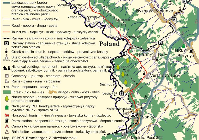
Nadsyansky Regional Landscape Park
|
|
|
- Gwendolyn Logan
- 6 years ago
- Views:
Transcription


1 Nadsyansky Regional Landscape Park photo: Z. Niewiadomski
2 The authors dedicate this publication to Prof. Stepan M. Stoyko, Ukrainian botanist who initiated works on establishing the Nadsyansky Regional Landscape Park and other protected areas in the Ukrainian Carpathians, the co-author of the concept for creating the World s first trilateral UNESCO-MaB Biosphere Reserve The East Carpathians and devoted scientist who spent many years in order to turn the vision of Carpathian nature conservation into reality. This publication is a part of the common Ukrainian-Polish project implemented in aimed at supporting the sustainable development of tourism in NRLP, which also included establishing the tourist database, park tourist map preparation, marking the tourist trail and setting up information boards, in order to facilitate your visits in Nadsyansky RLP. Financed by: The Foundation for the Eastern Carpathians Biodiversity Conservation was registered in Switzerland on January 9, 1995 with the objective to encourage, organize, conduct and promote activities serving to protect the overall biodiversity of the Eastern Carpathians Mountains zone. Internet: The Carpathian Foundation was founded in 1994 with the mission to provide financial and technical assistance to NGOs and local governments of the Carpathian Euroregion, focusing on inter-regional, economic development and transfrontier activities. Internet: Text: Oksana Maryskevych, Zbigniew Niewiadomski Translation from Ukrainian: Zbigniew Niewiadomski Photos.: Z.Niewiadomski (11), ECBC/V. Peslyak (1), ECBC/A.Szczerbicki (9) and I. Shpakivska (1). Maps: Piotr Bramberger, Richard Watzka/DAPHNE and Stanisław Strzyżewski in cooperation with Zbigniew Niewiadomski ECBC. Design: Stanisław Strzyżewski /

3 Nadsyansky Regional Landscape Park Nadsyansky Regional Landscape Park (NRLP) was established in 1997 in the state frontier zone on the area of 19,428 ha of six communities in Turka District, Lviv Province. The park stretches over two parallel mountain ridges on both sides of the European Continental Divide and harbours the sources of two major European rivers. The waters of the San River (with sources nearby the village of Syanky) flow to Vistula river and then to the Baltic Sea while the Dnestr River (originating nearby the village of Shandrovets) flows to the Black Sea. The name of the park reflects its location - along the San River on the Ukrainian state border with Poland (currently also the European Union external border). The two valleys in the park are quite different - the remote and inaccessible valley of the San River is left with almost no human settlements, while the other one densely populated is flourishing with the wealth of cultural heritage and traditional land-use forms. The population of NRLP accounts for inhabitants in 8 villages, harbouring numerous cultural heritage monuments. Forests and shrubs cover some 51.6 per cent and agricultural land accounts for as much as 42,9 per cent of the park area. Five nature reserves protecting semi-primeval beech, fir-beech and green alder treestands constitute the core zone of the Biosphere Reserve in NRLP. More than 30 plant species occurring in park area have been included into the Red Data Book of Ukraine, furthermore numerous habitats and species of the NRLP are those listed in Annexes to the EEC Habitat and Bird Directives, protected in the European Union. NRLP constitutes part of World s first trilateral Biosphere Reserve the East Carpathians. It borders another Ukrainian protected area - Uzhansky National Nature Park located in the Transcarpathian District as well as two neighbouring protected areas located across the river - Bieszczady National Park and the San River Valley Landscape Park in Poland. Our intention is to guide you in this picturesque area and help you to explore its beauty in different seasons of the year. Welcome to Nadsyansky Regional Landscape Park, one of the treasures of Ukraine! photo: Z. Niewiadomski

4 photo: ЕСВС/ A.Szczerbicki I Landscape of the park NRLP area is located within the Stry i-syan region of the Ukrainian Carpathians with altitudes in the range between 640 and 951 metres above the sea level. The landscape of the NRLP part along the state border is dominated by three mountain ridges ranging from north-west to south-east of the area: Chervony i Verkh (Ukrainian: red mountain ) with the elevation at Mt. Marhytyna (826 m), Syansky i ridge with Mt. Scholb (874 m) and Buchok ridge with Mt. Buchok (915 m) and the south-easternmost height of 951 m. Two single mountains - Mt. Kamenets (762 m) and Mt. Losivka (819m) raise between Chervony i Verkh and Syansky i ridges, among the characteristic steep hills in the upper San River valley the highest one is Mt. Kychera Syanska (888 m). In the northernmost part Chervony i Verkh ridge joins the Otryt mountain range in the Polish part of the Reserve, Buchok and Syansky i ridges are respectively from 6 to 10 km distant from and the European continental divide along the main East Beskid mountain range. From the main Lviv-Uzhgorod road nearby Borynya, under favourable weather conditions you can see the valley formed by mountain rivers Yablunka (Dnestr tributary) and Rika (San tributary) harbouring the villages of Boberka, Shandrovets as well as Nyzhnya and Verkhnya Yablunka. The second valley of the park, 14 to 16 km wide, stretches between the main East Beskid mountain range and mountain ridges along the San river, from its sources located close to Syanky village in the northwestern direction. The San river, within its 53-km long section between Syanky and Boberka constitutes the state border between Poland and Ukraine and simultaneously between the NRLP and the two Polish protected areas, also parts of the Reserve - Bieszczady National Park and the San River Landscape Park.


5 photo: Z. Niewiadomski Inhabitants of Sokolyky, Ternava Nyzhnya and Vyzhnya, Verkhny i Dzvynyach, Likot, Dydyova and Zhuravyn villages located in this valley have been expelled due to the operation of clearing the border zone undertaken between 1944 and 1946 by the Soviet regime. From this valley, for instance from the range of Likot, located above the former village of the same name one can admire broad vistas of the Polish part of the Reserve, beginning from Mt. Kińczyk Bukowski and Syanky village in the south-east to the village of Lutowiska and Mt. Smerek in the north-west. In the south, at the Uzhotska Pass the NRLP shares approximately 1-km long border with the second protected area included into the Ukrainian part of the Reserve - UzhanskyNational Nature Park. From the Uzhotska Pass you can see Uzhansky park in the south, the upper part of San river valley and surrounding water divide and Syansky i ridges as well as characteristic peaks of the Western Bieszczady Mts. - Mt. Kińczyk Bukowski (1251 m) and Mt. Halicz (1333 m). The main European Continental Divide between the San and Dnestr river catchments, thus between the Baltic Sea and the Black Sea drainage areas. The sources of the San river are located to the south from Syanky village and of the Dnestr river - close to Vowche village (nearby the village of Shandrovets). The Divide crosses the southernmost park areas in the vicinity of the Uzhotska Pass, turns northwards to Syanky village and continues in the north-western direction along Buchok and Syansky i ridges, and eastwards to Mt. Vysoka. From that point it follows the ridges towards the Northwest, parallel to the park border, and in its northernmost part, close to Boberka village, crosses the Polish border. I Nature in the park The major part of the NRLP area is covered by forests, mainly beech, fir and spruce, as well as by meadows and agricultural areas (hay-growing meadows, pastures and arable lands). Artificially planted spruce treestands, requiring stand reconstruction constitute the majority of NRLP forests. The most valuable beech, fir-beech and spruce-fir-beech forest complexes are preserved in Borynya and Yablunetske forestries of the park, therefore designation of forest nature reserves (2 in beech treestands and 3 in fir-beech treestands) is currently being considered. One green alder stand, quite unique for the park, was discovered on the slope of Mt. Vernik in the range of Buchok, to be designated the nature monument. photo: Z. Niewiadomski

6 photo: I. Shpakivska Communities with grey alder and wet meadows with numerous orchid species cover the terraces along the San river and the Polish- Ukrainian border. An oligotrophic moor located in the San river bend nearby Boberka village has exceptional flora of over 40 vascular plant species, including many rare ones. In the Syansky i ridge area a highmoor peatbog has also been discovered. As the result of recent intensive economic pressure vast areas of former forests changed into pastures, continuously overgrown by juniper. According to the results of research carried out by Ukrainian scientists (Prof. Stepan Stoyko) the NRLP flora is composed of over 700 vascular plant species, some 10 per cent of these are considered to be rare and threatened ones. Some 30 species have been included into the Ukrainian Red Data Book, e.g. the fir-club moss, ramson, belladonna, honesty, common snowdrop, Turk s cap lily, bird snest orchid and some other orchid species. Considerable human economy influence lead to decrease of the faunal diversity index of the NRLP. Reptiles and amphibians of the park include the adder, diced snake, smooth snake, viviparous lizard, Aesculapian snake and spotted salamander (the last two are included into the Ukrainian Red Data Book of Animals ). Mountain rivers are home to the river trout, golden loach, brook minnow and grayling. The rarities among 60 nesting bird species are the lesser spotted eagle, eagle owl and black stork. Typical mammals for the park area are the red deer, roe dear, wild boar, squirrel, the European polecat and red fox, while the otter, badger, pine marten, lynx, wolf, brown bear and wild cat are rarely seen here. I History and cultural heritage of the park area According to historians, the permanent human settlement process in nowadays NRLP area began at the break of the 1st and 2nd millennium A.D., in the times of the Kievan Ruthenia and Galicia-Volyn Principality, which is proved by the presence of old ramparts e.g. close to Nyzhny i Turiv, the possible location of an old-ruthenian fortified watchtower. According to Jan Długosz, Polish annalist - the legendary Sobin stronghold was build close to the sources of San and Dnestr rivers. An ancient trade and military route from Kievan Ruthenia to the Western Europe led along the San river between the city of Przemyśl and Uzhotska Pass. The process of intensive settlement in the upper Nadsyanya region began in 14th - 16th centuries, when this territory belonged to the Polish Kingdom and to Rzeczpospolita (the Republic) since In the first half of the 16th century the owner of all lands of the Sobień estate along the upper San river and its tributaries was Piotr Kmita, the Voivode of Kraków, who located the villages of Syanky, Sokolyky, Ternava Nyzhnya and Vyzhnya, Shandrovets, Verkhny i Dzvynyach, Dydyova, Boberka and Likot, thus a major part of villages, territories of which are nowadays incorporated to the Nadsyansky park.

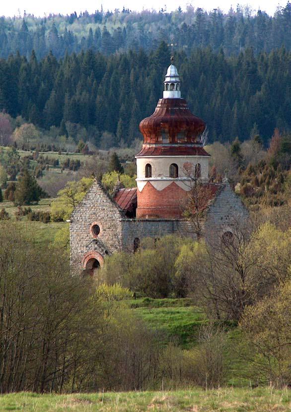
7 photo: Z. Niewiadomski In the second half of 16th century in crown lands of the Sambor estate the Polish King Zygmunt August and the Hungarian Queen Isabel located the villages of Dnistryk Dubovy i, Nyzhnya and Verkhnya Yablunka as well as Nyzhny i and Verkhny i Turiv, also inside the NRLP. Between 1772 and 1918 the whole Galicia including Turka region were incorporated by the Austro-Hungarian Empire, in 1918 the Nadsyanya was a part of the Western Ukrainian People s Republic, since 1919 in Poland and since 1939 within the borders of the Soviet Union. Beginning from 1991 the area is part of Ukraine. It is also worth to mention here the tragic history of Nadsyanya in , when over seven thousand inhabitants of eight villages (Sokolyky, Ternava Vyzhnya and Nyzhnya, Verkhny i Dzvynyach, Likot, Dydyova, Zhuravyn and Kryvka had been expelled from their homeland as the result of the operation aimed at clearing the border zone undertaken by the Soviet regime. Not only all the village buildings had been destroyed, but also the monuments of cultural heritage, including shrines - wooden tserkva churches built in either Boyko or neo- Ukrainian architectural style, most often demolished by the Soviet border guards as late as around Among the destroyed churches were the St. Demetrius tserkva built in 1791 in Sokolyky, Sts. Apostles Peter and Paul (1899) in Ternava Vyzhnya, St. Michael the Archangel (1894) in Ternava Nyzhnya, Dormition of the B. V. Mary (1860) in Dydyova, Immaculate Conception of the B. V. Mary (1901) in Kryvka, St. Michael the Archangel (1905) in Dzvynyach, St. Michael the Archangel (1907) in Benyova (on the left bank of the San river, plundered by the Polish People s Army soldiers in 1946 and burnt down in 1947), Transfiguration of Our Lord (1918) in Zhuravyn and St. Michael the Archangel (1927) tserkva in Likot village. Regardless the flow of time and changing political regimes the lifestyle of local inhabitants, mainly descendants of the Boyko ethnic group, changed slowly. Own dialect, original folk costume (e.g. geometric patterns and floral ornaments embroidered on sorochka shirts) the way of life as well as ancient folk customs and traditions distinguished the Boykos from other mountaineers. The park preserves numerous cultural heritage monuments, mainly Greek-catholic shrines and belfries - tserkva churches in Verkhnya Yablunka (Synaxis of the B. V. Mary, 1788), Nyzhnya Yablunka (Transfiguration of Our Lord, 1820), Verkhny i Turiv (St. Pantaleymon, 1890), Boberka (Ascension of Our Lord, 1913 and St. Michael the Archangel, 1914), Nyzhny i Turiv (Dormition of the B. V. Mary, 1914) and Dnistryk Dubovy i (Synaxis of the B. V. Mary / the Sacred Heart, 1920) often preserving unique Rybotych School icons and liturgical books from ancient, already non-existent wooden Boyko tserkva churches built between 16th and 18th century both in currently existing villages and in those destroyed long ago.
 and are preserved there until today.")
8 It is worth to mention here, that two ancient Boyko-style tserkvas built in Syanky village in 1645 and 1703 were sold to Kostryno (in 1703) and Sil (in 1831) villages in the Transcarpathian province (in the area of nowadays Uzhansky National Nature Park) and are preserved there until today. on communal towoky pastures and mountain polonyny meadows, where the shepherds immediately processed milk, mainly into bundts sheep cheese. In early 1990 s as soon as kolkhoses have been dissolved, local inhabitants returned to traditional landuse forms, husbandry and apiculture. This also caused the revival of many traditional crafts, including embroidery, weaving, smithery (you can visit traditional blacksmith s shops in Boberka and Verkhnya Yablunka), carpentry, wheelwright s craft (manufacture of wheels and carriages in Nyzhnya Yablunka) and cooperage. I Socio-economic situation of park inhabitants In NRLP area the population density reaches 46 inhabitants per square kilometre (which is over 75 times more than in areas on the Polish side across the San river) and accounts for some 9,008 inhabitants in 8 villages. The population size is growing due to high birth index, no matter unfavourable living conditions and high infant mortality index caused by insufficient financing of the health care system. Recently a negative trend in the age structure has been observed, affecting the well-being of the citizens: decreasing share of inhabitants in working age and growing share of two groups - retired people and children, who together account for 58 per cent of the park area population. Due to high unemployment rate and living standards being far from contemporary, the exodus of younger generations to Western Europe is common. Agricultural land in NRLP accounts for 42.9 per cent of the area. As the result of the land ownership reform initiated in 1990 in Ukraine these areas were transferred to employees of former collective ( kolkhos ) farms. Some 80 per cent of farmers manage plots smaller than 5 hectares, where traditional tools are still in use for growing grainphoto: ЕСВС/ A.Szczerbicki Traditional Boyko wooden architecture, e.g. single-house farms (so called long cabins ) linking both residential and farm functions under one roof has been preserved in the villages inside the park. On the initiative of metropolitan Andriy Sheptycky i one of such cottages, built in Shandrovets in 1909, has been transferred in 1930 s to the open-air Museum of Folk Architecture in Lviv. Farmers in the park still follow the old, naturefriendly terrace-like land use pattern, as well as two- and multi-course rotation methods, with the use of traditional farmers tools like ploughs, harrows, hoes, scythes, wooden pitchforks and flails. Livestock breeding is the traditional activity of NRLP area inhabitants. For centuries cattle, pigs, horses and sheep have been raised here, grazing
 or fishing (in Shandrovets, Nyzhnya")
9 crops, potatoes and vegetables. Livestock breeding is the predominant activity in the area. Ongoing degradation of mountain pastures is a negative factor, limiting agricultural production. Additional subsistence activities of the local inhabitants are collecting forest berries, bee-keeping (in Boberka, Verkhnya and Nyzhnya Yablunka, and in Syanky) or fishing (in Shandrovets, Nyzhnya Yablunka, Nyzhny i and Verkhny i Turiv). Forests cover 51.8 per cent of the park area. Forest management in state-owned forests is conducted by the Forestry Inspectorate in Borynya, subordinate to the Lvivlis State Forest Association, and by the municipal Galsil lis enterprise managing fragmented forests (former inter-kolkhos forests) of village co-operative companies. Due to severe economic condition of the population illegal cutting is common, especially in areas managed by Galsil lis. Currently secondary treestands dominated by spruce require urgent stand reconstruction. As a result of the agricultural impact, vast area of forests owned by village co-operatives has been transformed into meadows and pastures, which caused the decrease of biological diversity indexes due to progressive overgrowing of these areas by bushes and loss of rare and endangered plant species from floral communities composition. Nevertheless, no matter the strong human economy influence over 30 species included into the Red Data Book of Ukraine occur in NRLP area. Boberka Voivode of Kraków Piotr Kmita founded the village of Boberka in 1537 on the tributary of the San River - Boberka (beaver) stream, by issuing the settlement privilege to Ivan Volosh. The first tripartite Boyko-style churches (tserkva) in Boberka were built in the 16th and 17th century. In the Lower Boberka the St. Michael the Archangel tserkva built in 1913 preserves the Patronage of the B. V. Mary icon of 1759 and Evangelya book printed in 1743 in Lviv. In the Upper Boberka the Ascension of Our Lord tserkva built in 1914 harbours old church books printed in 1623 and 1737 in Lviv as well as fragments of interior decorations from tserkva churches demolished in Likot and Dydyova villages. The park surrounded the large manor in the 19th century, today the stone building hosts the elementary school. The village preserves many traditional Boyko wooden cottages and sawmills, the mill, ancient bridges and numerous roadside chapels and crosses. In the vicinity of the village you can see stony areas and an oligotrophic bog. Famous Ukrainian writer Ivan Franko often visited Boberka and nearby Dydyova village. Contrary to other frontier villages the population of Boberka was not displaced during the operation of clearing the border zone undertaken after 1939 by the Soviet Union. I Monuments of history and cultural heritage The Ukrainian part of the East Carpathians Biosphere Reserve has best preserved historical development of monuments and cultural traditions, which should become its competitive advantage for the tourism and related services in the area. photo: ЕСВС/ A.Szczerbicki

10 Nadsyansky Regional Landscape Park
11


12 Shandrovets The village of Shandrovets was founded before 1580 on the right tributary of the San River - Rika stream. It was the property of the Kmita family in the 16th century, inherited by the Tarnawski and Fredro families and later acquired by the Mniszko family in the late 17th century. The first tripartite Boyko-style church (tserkva) in Shandrovets was built before 1589 on a high hill in the centre of the village, close to the old road. It was replaced in 1755 by the St. Michael the Archangel wooden tserkva and later in 1924 by the St. John the Baptist tserkva used until today. The church preserves fragments of the old iconostas (wall of icons) from the 18th century and liturgical books printed in the 17th century in Lviv. Close to the tserkva you can see the churchyard and a two-tier wooden belfry built in The village well preserved traditional Boyko-style wooden cottages and sawmills, you can also find remnants of the narrowgauge railway embankment and numerous roadside chapels and crosses. The European Continental Divide ranges between Shandrovets and Verkhnya Yablunka villages. Verkhnya (Upper) Yablunka The village of Verkhnya Yablunka was founded in 1559 on the tributary of the Stryi River 1 - the Yablunka (apple tree) River by the King Zygmunt August who issued the settlement privilege to brothers Myhalovych from Przyslup. In 1796 a German colony was established in the village. The first wooden church (tserkva) was built in 1568, the Boyko-style new one, Synaxis of the B. V. Mary tserkva built in the close neighbourhood in 1788 serves the parish until today. It preserves numerous icons and liturgical books from the 17th and 18th century, and icons stored in the attic, from tserkva churches demolished in Ternava Vyzhnya, Ternava Nyzhnya and other no longer existing villages. To the west of tserkva you can see a three-storey wooden belfry of 1797 harbouring old Rybotych School icons painted between the 16th and 18th century, in the churchyard you will find several old photo: ЕСВС/ A.Szczerbicki photo: ЕСВС/ A.Szczerbicki sepulchral crosses and graves of Russian and Austro-Hungarian soldiers who died here during the World War I. The village harbours traditional Boyko-style wooden cottages, fences, sawmills and bridges, numerous roadside chapels and crosses. In 2000 an orthodox church was built. The European Continental Divide ranges between Verkhnya Yablunka and Shandrovets villages.
 was established in 1522 on the tributary of the Stryi River - the Yablunka River based on the privilege")
 was built between")
13 photo: ЕСВС/ A.Szczerbicki Nyzhnya Yablunka The village of Nyzhnya Yablunka (initially Yablunka Chernetska) was established in 1522 on the tributary of the Stryi River - the Yablunka River based on the privilege issued by Voivode of Kraków Piotr Kmita to Khrych Valashyn Tharnavsky. In the past it also harboured a small German colony. The first wooden tserkva was built in Nyzhnya Yablunka before The renovation of this church was no longer possible in 1803, therefore a new church, this time masonry one, Transfiguration of Our Lord tserkva (monument of architecture) was built between , in service until today. It preserves the Ascension of Our Lord aisle altar dated 1786 from the old tserkva. Churchyard is located close to the tserkva. In the neighbourhood of the railway station a wooden Roman-catholic chapel was built in 1911, demolished in Before the World War I a dritban ropeway crossed Nyzhnya Yablunka to transport timber to Borynya, nowadays only the foundations of its supporting structure can still be seen. Nyzhny i Turiv The village of Nyzhny i (Lower) Turiv was founded on the tributaries of the Yablunka River - Pysana River, Yasen and Roshchen streams in 1556 by the Queen Isabel, who issued the settlement privilege to Pavel Ivashkovytsch and Teodor Jatschkovytsch, confirmed by the privilege of 1567 by the King Zygmunt August. The old tserkva from 1556 was replaced in 1792 by the new Latinised style wooden tserkva, demolished in 1913 (remnants of its foundations can still be seen). In the vicinity the Dormition of the B. V. Mary neo-ukrainian style tserkva was built in 1914, harbouring the 18th century icon from the old church and Evangelya book printed in 17th century in Lviv, originally from St. Demetrius tserkva in Sokolyky. Close to the tserkva you can see a three-storey wooden belfry of 1914 and several old sepulchral crosses in the churchyard. The village preserves numerous traditional Boyko-style wooden cottages and fences, old bridges and many roadside chapels and crosses. Verkhny i (Upper) Turiv The village of Verkhny i (former Royal ) Turiv was founded in 1556 on the tributary of the Yablunka River - the Skolaban stream, based on the privilege issued by the Queen Isabel. The first wooden tserkva was built in early 18th century. In the close vicinity, in the place after the manor s chapel, the new wooden Latinised style St. Pantaleymon photo: ЕСВС/ A.Szczerbicki

14 photo: ЕСВС/ A.Szczerbicki tserkva was built in 1890, preserving until today liturgical books printed in the 18th century and the iconostas (wall of icons) from the early 20th century. To the west of tserkva you can see the two-tier wooden belfry built at the same time as the church. The churchyard surrounds the tserkva. Almost all buildings in Verkhny i Turiv are made of timber, the village preserves traditional Boyko-style wooden cottages and fences from the early 20th century, old bridges and numerous roadside chapels and crosses. Syanky Voivode of Kraków, Piotr Kmita founded the village of Syanky before 1580 close to the sources of the San River. Between the 17th and 19th century three wooden Boyko-style churches (tserkva) were built in Syanky, two of them (from 1645 and 1703) have been sold to the Transcarpathian Province and are still preserved there, in Kostryno and Sil villages. As early as in the 1870s a railway crossed the village, linking Uzhgorod with Przemyśl and Lviv, and the railway station was built in Before the World War II the capacity of 10 holiday resorts, 6 pensions and 3 tourist hotels reached almost 2,000 beds; the village had its theatre, library, tennis-courts, ski-jumping take-off, toboggan-run and meteorological station. St. Stephen (1831) and St. Elijah (1908) tserkvas as well as the Roman-catholic church were demolished after the World War II, and the stone-built manor s chapel around Part of Syanky village is called Ropa which is the reminder of salt mining in the past. In the 1990s two churches were built in Syanky: the Greek-catholic St. George (1993) tserkva and the Ascension of Our Lord orthodox church (1996). In St. George tserkva you can see a chandelier from the old St. Elijah tserkva and the bell from the tserkva of Benyova village. The village of Syanky harbours a military cemetery of the World War I, traditional Boyko-style wooden cottages and fences, sawmills, old bridges and numerous roadside chapels and crosses. Uzhotska Pass Uzhotska Pass (852 m a.s.l.) on the European Continental Divide is located very close to the border between Uzhansky National Nature Park and Nadsyansky Regional Landscape Park as well as the border between Ukrainian and Polish parts of the East Carpathians Biosphere Reserve. The sources of the San River are also close to the pass. A railway built across Uzhotska Pass in the 70s of the 19th century linked Uzhgorod with Przemyśl and Lviv. In the vicinity you will find the monument commemorating the Ukrainian Soldiers, a military cemetery and a monument to Austro-Hungarian and Russian soldiers who died here during the World War I. A line of trenches from these times is well preserved in the Buchok nature reserve of the Borynya State Forestry. From the pass you can see nearby peaks of the Western Bieszczady Mountains in the Polish part of the East Carpathians BR - Mt. Kińczyk Bukowski (1251 m a.s.l.) and Mt. Halicz (1333 m a.s.l.) in Bieszczady National Park.
 to the northeast from the European divide was in the past by mistake considered to be the beginning of the Dnestr river.")
15 Dnistryk Dubovy i The village of Dnistryk Dubovy i was founded in 1567 based on the privilege issued by the King Zygmunt August to brothers Khrycek and Lukash, on the right tributary of the Dnestr River, bearing the same name as the village. Only 4.5 km long Dnistryk Dubovy i stream rising from the slope of Mt. Vysoky Verkh (700 m a.s.l.) to the northeast from the European divide was in the past by mistake considered to be the beginning of the Dnestr river. The village belonged to crown lands of the Rozluch part of the Sambor estate. The wooden tserkva in Dnistryk Dubovy i was built in 1751, replaced in 1856 by the second one, seriously damaged during the battles of World War I. The church serving today, the Sacred Heart tserkva was built in 1921 in the neo-ukrainian style. It preserves interesting embroidered icons of B. V. Mary and Christ, following the example of icons from 1911 by Osip Kurylas. The wooden building of former nunnery from 1930 s, the churchyard with few old sepulchral crosses and a wooden belfry from 1960 s are located close to the tserkva. The village harbours traditional Boyko-style wooden buildings, many roadside chapels and crosses. I Non-existent villages The NRPK includes areas of seven deserted villages: Zhuravyn, Dydyova, Likot, Verkhny i Dzvynyach, Ternava Nyzhnya, Ternava Vyzhnya and Sokolyky, inhabitants of all these villages have been expelled between 1939 and At the instance of contemporary Soviet and Polish regimes over seven thousand people were dispersed on different sides of nowadays Ukrainian-Polish border and deserve mentioning their little motherlands swept over by the cruel 20th century. Zhuravyn The chronicle mentions issuing the locating privilege for the village to knight Zanko of Turka by the Polish King Władysław Warneńczyk even before It was the most ancient settlement of the upper San river valley, located at the former Roman trading route. Three wooden tserkva churches were built between 16th and 19th century in Zhuravyn, the village also harboured a small Basilian monk s monastery and a manorial brewery. In 1831 the number of inhabitants reached 850 people. Close to the old church, seriously damaged during the battles of World War I a new one - Transfiguration of Our Lord tserkva was built in 1918 in the neo-ukrainian style, destroyed by the Soviet border guards in The village with the population accounting in 1943 for 808 inhabitants was displaced between photo: Z. Niewiadomski

16 photo: Z. Niewiadomski due to the operation of clearing the border zone. In 1945 the church interior decorations have been removed to tserkvas in Dnistryk Dubovy i and Zhukotyn. Dydyova Voivode of Kraków Piotr Kmita founded the village of Dydyova before In 1589 a tserkva church was erected here, replaced in 1740 by the second wooden shrine which burnt down in In 1860 a wooden tripartite Dormition of the B. V. Mary tserkva was built, later destroyed in 1956 by the Soviet border guards, this fact is commemorated by a small plaque set up by the neighbouring communities. Ivan Franko, the famous Ukrainian writer used to come together with his wife to Dydyova each year in order to visit Ivan Kuziv, his schoolmate, local priest and the expert on ethnography of the Boykos. An agricultural Syhla Co-operative and Prosvita reading room operated before the World War II. The village with the population accounting in 1938 for 1,332 inhabitants was displaced between due to the operation of clearing the border zone. Until 1993 the interior decorations from the tserkva preserved in the church in Dnistryk Dubovy i have been taken back by the former Dydyova inhabitants resettled to Sokal area. The remnants of the village are the ruins of the manor blownup in 1960 s and of the carpenter s house hosting Ivan Franko (arrested in Dydyova in 1890) in late 19th century, large foundations of another building, few tombstones in the cemetery and two roadside crosses. Likot The village of Likot was founded by Voivode of Kraków Piotr Kmita before The oldest documents mentioning the tserkva in Likot come from A tripartite wooden St. Michael the Archangel tserkva was erected in 1737, replaced in 1927 by another one, later destroyed by the Soviet border guards in In 1938 the number of inhabitants of Likot reached some 655 people. The village with the population accounting in 1943 for 466 inhabitants was displaced between and the church interior decorations have been removed to the tserkva in Boberka. The ring of trees clearly marks the place after the destroyed tserkva, surrounding its foundations and the churchyard with few tombstones. The Lymych family set the cemetery in order, placed 3 crosses in the place after the tserkva and an obelisk nearby the cemetery. Verkhny i Dzvynyach Voivode of Kraków Piotr Kmita located the village of Verkhny i Dzvynyach before The tax register of 1589 mentions the first tserkva, the second wooden tserkva was built in 1789 on the left bank of the San river. In 1905 the St. Michael the Archangel tserkva was erected on the right bank of the San river, later destroyed after the World War II. The local priest Yuriy Kmit carried out research on the Boyko folklore and was the author of the Boyko Dialect Vocabulary. In 1938 the number of inhabitants of Verkhny i Dzvynyach reached 1,549 people. The village with the population accounting in 1943 for 859 inhabitants was displaced between The foundations of tserkva from 1905 remain on the Ukrainian side. photo: Z. Niewiadomski

17 photo: Z. Niewiadomski Ternava Vyzhnya The chronicle mentions granting this land to knight Zanko of Turka by the Polish King Władysław Warneńczyk even before The village of Ternava Vyzhnya was founded over the San river in 1537 on the basis of the privilege issued by Voivode of Kraków Piotr Kmita to pope Vasil Ilnytsky i. The tserkva in Ternava Vyzhnya was for the first time mentioned in tax register of The next tserkva was erected in 1746, and the Sts. Apostles Peter and Paul tserkva was built in its neighbourhood in 1889, destroyed after the World War II, it is still quite easy to find places after the tserkvas in Ternava Vyzhnya. In early 1915 bloodily battles of the World War I took place around the village. Industrial plant located on the right bank of the San river processed beech timber transported by the narrow-gauge train into furniture parts, exported as far as to France, Belgium and the Netherlands. In 1931 the number of Ternava Vyzhnya inhabitants reached 813 people. Prosvita reading room operated here in 1930 s. The village with the population accounting in 1938 for 765 inhabitants was displaced between Currently 30 residents of nine cottages inhabit the area of the former village. Ternava Nyzhnya The documents mention granting this area to knight Zanko of Turka by the Polish King Władysław Warneńczyk even before Similarly as Ternava Vyzhnya this village was founded over the San river in 1537 on the basis of the privilege issued by Voivode of Kraków Piotr Kmita to pope Vasil Ilnytsky i. The tserkva in Ternava Nyzhnya most probably existed in The second wooden tserkva was built in 18th century and survived until the end of 19th century. In 1894 the St. Michael the Archangel tserkva was erected on the right bank of the San river. It was destroyed after the World War II and the church interior decorations have been removed to the tserkva in Verkhnya Yablunka. In 1931 the number of Ternava Nyzhnya inhabitants reached 1,065 people. The village with the population accounting in 1938 for 929 inhabitants was displaced between The remnants on the Ukrainian side are the tserkva foundations and ruins of the belfry built of stone. Sokolyky Voivode of Kraków Piotr Kmita founded the village of Sokolyky before Tax registers of 1640 and 1655 contain the first references to the tserkva in Sokolyky. In 1791 the new wooden tripartite St. Demetrius, the Great Martyr tserkva was erected, and in 1931 the masonry one in its close vicinity. Due to the construction of railway Sokolyky became the local centre of timber industry and the local sawmill employed over 200 workers, while more than 100 people worked for the railway. In 1931 the number of Sokolyky inhabitants reached 1,716 people. The village developed also as the holiday resort, in 1937 it harboured seven summer pensions and the Fairy-tale Carpathian House for the young. In June 1944 a squad of 400 Azer soldiers from the partisans group under the command of Sydor Kovpak conquered the fortified Nazi border guard outpost on the left bank of the San river, attacking across


18 photo: Z. Niewiadomski the minefield. The village with the population accounting in 1938 for 1,520 inhabitants was displaced between The wooden tserkva was destroyed after the World War II and the masonry one was used by the Soviet border guards as the point of vantage and stables. Currently establishing the museum of resettled villages in the tserkva is planned. I Nadsyansky RLP activities The objective for Nadsyansky Regional Landscape Park designation was to ensure the ecological balance in the upper San river valley shared by Ukraine and Poland in the way of extending the borders of the Biosphere Reserve to the San watershed; incorporation of additional areas on the northern slopes of Beskid Mts. also increased its natural representativeness. The main task for the NRLP with the headquarters in Borynya is to implement such forms of forest management and agriculture that will foster the preservation of biological diversity and sustainable development of this area, simultaneously allowing the rational use of its landscape for tourism and recreation. This young park still needs to carry out the inventory of its flora and fauna in order to define the ranges of species and habitats protected in Ukraine and in the European Union. Ultimate borders of forest reserves have to be designated and nature monuments identified. The history, ethnography and cultural heritage must be studied and the best way of protecting this unique area has to be found together with the local selfgovernments and park inhabitants. This is the only way to provide foundations for the economic development of the park area by implementing the sustainable development strategy based on maintaining the traditional land-use forms, developing local products as well as attaining additional income from tourism and recreation, facilitated by developing hiking, bicycle and horseback trail network. photo: ЕСВС/ A.Szczerbicki
19 I Practical hints for visitors Camping is allowed close to the location of the former village of Benyova. Due to the fact, that NRLP is located in the state frontier zone all visitors are required to bear valid passports, visiting the upper San river valley (only in organised groups) is possible subject to prior written consent issued by the Border Guard of Ukraine. The nearest bank and money vending machine are available in Turka. Overnight accommodation (as for 2005) is available in private family houses owned by: in Boberka - Mykola Butriy, Galyna Pron o, Anatoliy Bizhyk and Ivan Fedash; in Shandrovets - Hanna Zgoba, Mykola Saray, Anna Pyptyk and Ivan Startsun; in Verknya Yablunka - Paraskoviya Semkiv and Bogdan Shyika. and also in other farms and villages of the NRLP, at moderate prices. If you plan to ski, ride a horse or take a ride in a horse-driven carriage in NRLP - ski, horse and carriage rental is available in Boberka at Igor Perih, Petro Sirko, Vasil and Yaroslav Slavych, and in Verkhnya Yablunka from Mykola Zaets and Ivan Kl ob. All villages in NRLP are within the operational range of two Ukrainian mobile phone operators: UMS and UA Kyivstar. In addition to the above in Syanky you can also get connection via Polish mobile phone operator ERA GSM, and when walking on top of NRLP mountain ridges or in the San River Valley also Polish mobile phone operator Plus GSM and others, depending on the location. For your own safety please remember that in hilly terrain mobile phone coverage may not be available in each place of the park. Post office services, food-stores with basic products and coffee stands are available in all villages of the NRLP. Small pharmacies operate in Boberka, Shandrovets, Verknya and Nyzhnya Yablunka, Nyzhny i and Verkhny i Turiv, and in Syanky. Public transportation is available: by bus to all NRLP villages currently except for Verkhny i Turiv; by train to the main railway stations of the Lviv - Syanky - Uzhgorod line located in Syanky and Nyzhnya Yablunka, and smaller railway stops in Nyzhny i Turiv, Sokolyky and Benyova. Please note that the road section between Borynya and Boberka is currently not well maintained, therefore 4WDs are much more suitable for sightseeing than regular cars. Petrol station is located at the crossroads in Borynya, next to the main road from Turka to Uzhotska Pass and Uzhgorod. For more detailed information on the Nadsyansky RLP please contact: Regional Landscape Park Nadsyansky smt Borynya, Lisova Str.1, Lvivska oblast, Turkivskyi rajon Ukraine phone No: , In an emergency please contact: Health centre in Verknya Yablunka (phone No ); Police station in Verknya Yablunka (phone No ), Nyzhnya Yablunka (phone No ), and in Syanky (phone No ); Border Guard Station in Boberka (phone No ) or in Syanky (phone No ); Local First Aid stations in Boberka, Shandrovets, Verknya and Nyzhnya Yablunka, Nyzhny i and Verkhny i Turiv, Syanky.

20 I The East Carpathians Biosphere Reserve In November 1992, under the Man and Biosphere Program, UNESCO designated a Polish-Slovak bilateral Biosphere Reserve. In October 1998 the Ukrainian part joined to form the first trilateral Biosphere Reserve the East Carpathians - a unique treasure of global importance, combining immense wildlife value with rich cultural heritage. The reserve contains some of the least disturbed ecosystems e.g. part of the largest European natural beech forest complex, Eastern Carpathian mountain meadows called poloniny, protects endemic and threatened mountain plant species and communities. It constitutes one of the most important refuges for large animals of primeval habitats of Europe. Unique fauna is composed of all native big predators like the brown bear, wolf, lynx and golden eagle, as well as all big native herbivorous mammals like the European bison, red deer and reintroduced primitive Hutzul horse and beaver. The reserve covers 213,212 hectares (in Poland 53,4, in Slovakia 19,1 and in Ukraine 27,5 per cent of the total area) and encompasses six protected areas: Bieszczady National Park, Cisna-Wetlina and San Valley two Landscape Parks in Poland; Poloniny National Park and its buffer zone in Slovakia; Uzhansky National Nature Park and Nadsyansky Regional Landscape Park in Ukraine.

21 Selected literature on NRLP area: photo: ЕСВС/ V. Peslyak Augustyn M., Szczerbicki A.: Na północ od źródeł Sanu. Zabytki w wsiach nad rzekami Boberką i Jabłonką, [in:] Bieszczad Nr 7, Towarzystwo Opieki nad Zabytkami, Oddział Bieszczadzki, Ustrzyki Dolne Augustyn M., Kryciński S., Modrzejewski S., Szewc R.: Bieszczady. Słownik Historyczno-Krajoznawczy. Część 1 - Gmina Lutowiska., Bieszczadzki Park Narodowy - Wydawnictwo Stanisław Kryciński, Ustrzyki Górne - Warszawa Bieszczady. Przewodnik, wyd. VI, Oficyna Wydawnicza Rewasz, Pruszków Бойківщина. Історико-етнографі-чне дослідження, Київ: Наукова думка 1983 Bojkowszczyzna, Płaj nr 6, Towarzystwo Karpackie, Warszawa Kryciński S.: Cerkwie w Bieszczadach, Oficyna Wydawnicza Rewasz, Pruszków 1995 Pulnarowicz W.: U źródeł Sanu, Stryja i Dniestru, Turka Слободян В.: Церкви Турківського району, Львів Сокіл В.: Народні легенди та перекази українсців Карпат, Київ: наукова думка, Stoyko S.: Ukrainian Part of the Trilateral East Carpathians Biosphere Reserve [in:] The East Carpathians Biosphere Reserve Poland /Slovakia/ Ukraine ; Polski Komitet Narodowy MaB, Warszawa Stoyko S.: Park Krajobrazowy Górnego Sanu / The Landscape Park of the Upper San (proposed) [in:] Rezerwaty Biosfery w Polsce / Biosphere Reserves in Poland, wyd. II, Polski Komitet Narodowy MaB, Warszawa Украинские Карпаты. Культура, Наукова Думка, Киев Украинские Карпаты. Природа, Наукова Думка, Киев Юсипович І.: Турківщина: за завісою століть, Львів: ВП Край, 1993.

22 photo: Z. Niewiadomski
628: BELOVEZHSKAYA PUSHCHA STATE NATIONAL PARK (BELARUS)
") WORLD HERITAGE NOMINATION - IUCN SUMMARY 628: BELOVEZHSKAYA PUSHCHA STATE NATIONAL PARK (BELARUS) Summary prepared by WCMC/IUCN (April 1992) based on the original nomination submitted by the Government
WORLD HERITAGE NOMINATION - IUCN SUMMARY 628: BELOVEZHSKAYA PUSHCHA STATE NATIONAL PARK (BELARUS) Summary prepared by WCMC/IUCN (April 1992) based on the original nomination submitted by the Government
New Ramsar sites for Poland
 New Ramsar sites for Poland 31 October 2005 Poland Poland designates five new Wetlands of International Importance The Secretariat is pleased to announce that the Government of Poland has designated five
Biosphere Reserves of India : Complete Study Notes
 Biosphere Reserves of India : Complete Study Notes Author : Oliveboard Date : April 7, 2017 Biosphere reserves of India form an important topic for the UPSC CSE preparation. This blog post covers all important
2.0 PARK VISION AND ROLES
 2.0 PARK VISION AND ROLES 2.1 Significance in the Protected Area System Marble Range and Edge Hills provincial parks protect 6.8% of the Pavillion Ranges Ecosection, which is located in the Southern Interior
The Design of Nature Reserves
 The Design of Nature Reserves Goals Maintenance of MVP s for targeted species Maintenance of intact communities Minimization of disease Considerations of reserve design 1. Disturbance regime Fire Insect
NEWS. On December 18, 2017 study visit to ruined fort Bzovík, Slovakia, took place. Slovakia
 1/2018 (3) NEWS On December 18, 2017 study visit to ruined fort Bzovík, Slovakia, took place. Slovakia Location of Bzovík (source: maps.google.com) The ruins of fort/monastery Bzovik are situated in the
April 10, Mark Stiles San Juan Public Lands Center Manager 15 Burnett Court Durango, CO Dear Mark,
 Mark Stiles San Juan Public Lands Center Manager 15 Burnett Court Durango, CO 81301 Dear Mark, We are pleased to offer the following comments on the draft San Juan Public Lands Center management plans
Balkan Lynx Recovery Programme NEWSLETTER 02/2011
 Balkan Lynx Recovery Programme NEWSLETTER 02/2011 First picture of a Balkan lynx in Albania Results from the camera-trapping surveys in 2011 The Balkan lynx team managed to picture the first lynx in Albania
 AGREEMENT Between Director of the Białowieża National Park, based in Białowieża (Poland) and Director of the National Park Bialowieża Forest, based in Kamieniuki (Belarus) and Head Forester of the Białowieża
Andy Sharp Natural Resources Northern & Yorke. Brooke Liebelt Yorke Peninsula Tourism
 Andy Sharp Natural Resources Northern & Yorke Brooke Liebelt Yorke Peninsula Tourism Rewilding is about restoring natural processes, to: improve conservation outcomes improve the ecosystem services provided
Participating quarry information
 Participating quarry information 1. Contact information Company: Sand & Grus AB Jehander Quarry: Latitude / Longitude: City: Region: Country: Löten 59.422972 N / 17.582068 E Munsö Stockholm Sweden 2. General
B HALL RANCH FISHTAIL, MONTANA
 Brochure Courtesy of: B HALL RANCH FISHTAIL, MONTANA w w w. m c c a s l i n l a n d. c o m Page 1 LOCATION The Hall Ranch is ideally located in the foothills of the Beartooth Mountains, approximately 5
BABIA GÓRA DECLARATION ON SUSTAINABLE TOURISM DEVELOPMENT IN MOUNTAIN AREAS
 BABIA GÓRA DECLARATION ON SUSTAINABLE TOURISM DEVELOPMENT IN MOUNTAIN AREAS The participants of the International Workshop for CEE Countries Tourism in Mountain Areas and the Convention on Biological Diversity",
RAY YENKANA Willowbrook Cr, Dawson Creek BC Canada $2,847,000
 1716 Willowbrook Cr, Dawson Creek BC Canada For SALE $2,847,000 This is a rare find, 32 townhomes in Dawson Creek, BC. Excellent investment in a single title multi family complex. Vendor has upgraded this
Dancers from Slovakia Bratislava. Slovakia is a beautiful country in Central Europe with a rich culture heritage
 Dancers from Slovakia Bratislava Slovakia is a beautiful country in Central Europe with a rich culture heritage The group Dancers from Slovakia is composed by the group Dancers from Lúčnica and children's
FINAL STAG E : 5 T H G R A D E
 NAME COURSE SURNAME CENTRE YOUR TEACHER S NAME FINAL STAG E : 5 T H G R A D E 1. Read Danny s diary and complete his timetable. Remember there are extra words! EXTINCT / WATERFALL / VALLEY / PATH / WOOD
Spanish Missions History and Purpose
 Spanish Missions History and Purpose Columbus's voyage of discovery opened a new world of possibilities for the Spanish. In the Americas, Spain soon began to use its soldiers to increase the size of its
Marchand Provincial Park. Management Plan
 Marchand Provincial Park Management Plan 2 Marchand Provincial Park Table of Contents 1. Introduction... 3 2. Park History... 3 3. Park Attributes... 4 3.1 Natural... 4 3.2 Recreational... 4 3.3 Additional
Figure 1.1 St. John s Location. 2.0 Overview/Structure
 St. John s Region 1.0 Introduction Newfoundland and Labrador s most dominant service centre, St. John s (population = 100,645) is also the province s capital and largest community (Government of Newfoundland
Current conditions. Guatemala's Maya Biosphere Reserve. No clear idea of speed of deforestation. Deforestion by pollen analysis
 Current conditions Most obvious human transformation is cutting of forests Guatemala's Maya Biosphere Reserve An Eco-Friendly Adventure Along the Maya Trails Key ecological roles: repository for biodiversity
Chapter 12 Study Guide Eastern Europe
 Chapter 12 Study Guide Eastern Europe Eastern Europe is called a. The,, and of countries are constantly changing. I. Baltic Region: Landform that dominates is the Plain A. Poland: suffered due to a lack
Poland & Ukraine combo
 Poland & Ukraine combo Style: Signature Dates: June 29 July 13, 2018 Duration: 15 Days/ 14 Nights Start Krakow End Kyiv Be the first to enjoy our brand new combo tour, taking you through the most beautiful
Seager Wheeler Lake. Representative Area. -- Concept Management Plan --
 Seager Wheeler Lake Representative Area -- Concept Management Plan -- Saskatchewan Environment and Resource Management January, 1999 Saskatchewan s Representative Areas Network Program The Government of
European Union Delegation in Albania Organization for Security and Co-operation in Europe Presence in Albania
 The Secretariat of the Convention on the Conservation of European Wildlife and Natural Habitats (Bern Convention). The Secretariat of the Convention on Wetlands of International Importance especially as
GEOGRAPHY AND HISTORY
 GEOGRAPHY AND HISTORY YEAR 1, PART 1 www.vicensvives.es Contents 01 Our planet Earth 02 The representation of the Earth: maps 03 The Earth s relief 04 Rivers and seas 05 Weather and climate 06 Climates
Belarus seminar on transboundary wetland sites
 Belarus seminar on transboundary wetland sites 12 May 2004 Belarus Transboundary Ramsar Sites On 28-29 April 2004, a seminar on transboundary wetland sites took place in the town of Lida (Republic of Belarus),
MONTENEGRO EXPLORER 7 days
 7 days Countries visited Montenegro Tour Highlights Ottoman architecture of Podgorica Spectacular Tara gorge See the Monastery Ostrog perched on the cliffs The pretty Riviera town of udva Sample Njegusi's
IV International Symposium Agrosym /AGSY M NATURAL RESOURCES AND THE ENVIRONMENT OF UPPER DANUBE
 10.7251/AGSY1303899M NATURAL RESOURCES AND THE ENVIRONMENT OF UPPER DANUBE Nada MIJAJLOVIC*, Vesna POPOVIC, Jonel SUBIC Institute of Agricultural Economics, Belgrade, Serbia *(Corresponding author: nada_m@iep.bg.ac.rs)
2.0 Physical Characteristics
 _ 2.0 Physical Characteristics 2.1 Existing Land Use for the Project The site is comprised of approximately 114 acres bounded by Highway 101 to the north, the existing town of Los Alamos to the east, State
Best of BELARUS for 2019
 Best of BELARUS for 2019 Minsk Dudutki Mir Nesvizh Berezinsky Reserve - Minsk DAY 1: MINSK (arrival) Arrival in Minsk, transfer to hotel. DAY 2: MINSK - DUDUTKI - MINSK Minsk guided tour. During the excursion
43. DEVELOPMENT AND DISTRIBUTION OF TOURISM
 Tourism Tourism is one of the world s largest industries. In many regions it is also the greatest source of revenue and employment. Tourism demand is based on the values and needs of modern tourists, while
Asociatia Sentire YOUTH EXCHANGE Horezu, ROMANIA
 Asociatia Sentire YOUTH EXCHANGE 04.02.2019 12.02.2019 Horezu, ROMANIA About the organizers: The association SENTIRE is an organisation that has as purposes the development of youth, helping out those
Forms of Natural Protection in Greece
 Forms of Natural Protection in Greece 105 th Primary School of Thessaloniki NATIONAL PARKS AND PROTECTED AREAS The irregular and constantly increasing human intervention in nature and the relentless exploitation
GUIDED CYCLE TOUR - 8 DAYS / 7 NIGHTS
 GUIDED CYCLE TOUR - 8 DAYS / 7 NIGHTS Experience the atmosphere of Bulgarian monasteries and history on a bike. This tour is not just a circuit of some of the most interesting Bulgarian monasteries. It
9 Days Jewel of Poland - Europe
 9 Days Jewel of Poland - Europe Vacation Overview Rich cultural heritage, fascinating history, and beautiful landscapes make Poland an interesting place to discover. This brilliant getaway begins in the
Blanco Creek Ranch Acres, Uvalde County, Texas
 Blanco Creek Ranch 1208.30 Acres, Uvalde County, Texas James King, Agent Office 432 426.2024 Cell 432 386.2821 James@KingLandWater.com Blanco Creek Ranch 1208.30 acres Uvalde County, Texas James King,
We, Ministers, assembled in Berlin for the International Conference on Biodiversity and Tourism from 6 to 8 March 1997
 March 8th, 1997 Berlin Declaration BIOLOGICAL DIVERSITY AND SUSTAINABLE TOURISM We, Ministers, assembled in Berlin for the International Conference on Biodiversity and Tourism from 6 to 8 March 1997 -
Flexibility of course stays necessary if recent observations/tracks were made/found in other areas, by contacts of Felix.
 POLAND MARCH 2012 HOW THE LYNX QUEST BECAME A WOLF ENCOUNTER Some impressions according the participants: An overall very enjoyable trip mammals: no lynx but none of participants thought this would be
TAYLOR CANYON RANCH COLORADO - ROUTT COUNTY - STEAMBOAT SPRINGS
 TAYLOR CANYON RANCH COLORADO - ROUTT COUNTY - STEAMBOAT SPRINGS Tucked up against the steep valley shaped by Mt. Pau and rising to the Routt National Forest, Taylor Canyon Ranch is an easily accessible,
Pembina Valley Provincial Park. Draft Management Plan
 Pembina Valley Provincial Park Draft Management Plan 2 Pembina Valley Provincial Park Table of Contents 1. Introduction... 3 2. Park History... 3 3. Park Attributes... 3 3.1 Natural... 3 3.2 Recreational...
SOUTHERN ADVENTURE Tour: A-1 9 Days / 8 Nights LAND ONLY TOUR ITINERARY: DAY 1 DAY 2 DAY 3
 SOUTHERN ADVENTURE Tour: A-1 9 Days / 8 Nights LAND ONLY TOUR ITINERARY: DAY 1 Saturday WARSAW (Welcome dinner) After arrival, you will be met and transferred to your hotel in the heart of the city. The
(4) Protected Areas in Japan 4-1) Outlines of Protected Area Systems in Japan
 Protected Areas in Japan 4-1) Outlines of Protected Area Systems in Japan") (4) Protected Areas in Japan 4-1) Outlines of Protected Area Systems in Japan a) Protected Areas System Under the Nature Conservation Law 1) Wilderness Areas To conserve primeval natural environment, natural
(4) Protected Areas in Japan 4-1) Outlines of Protected Area Systems in Japan a) Protected Areas System Under the Nature Conservation Law 1) Wilderness Areas To conserve primeval natural environment, natural
REPORT on the Belarus MAB National Committee activity for
 REPORT on the Belarus MAB National Committee activity for 2010-2011 The main directions of activity of the Belarus MAB National Committee in 2010-2011 included coordination of the activity of national
Map 1.1 Wenatchee Watershed Land Ownership
 Map 1.1 Wenatchee Watershed Land Ownership Map 1.1 Wenatchee Watershed Land Ownership The Wenatchee watershed lies in the heart of Washington state in Chelan County. Just larger than the state of Rhode
ANALYSIS OF INADEAUTE WATER QUALITY OD THE RESERVOIR VONARJE/SUTLA LAKE AND POSSIBILITY OF RESTORATION AND UTILIZATION
 EC project on Integration of Natural Water Retention Measures in river basin management The 1 st Danube Region Workshop ANALYSIS OF INADEAUTE WATER QUALITY OD THE RESERVOIR VONARJE/SUTLA LAKE AND POSSIBILITY
Geoscape Toronto The Oak Ridges Moraine Activity 2 - Page 1 of 10 Information Bulletin
 About 13,000 years ago as the Laurentide Ice Sheet melted, glacial meltwater accumulated between the ice sheet and the Niagara Escarpment. This formed a lake basin into which gravel and sand were deposited.
ENVIRONMENTAL PROFILE:
 Pyrenees Study Area for LEDDRA LOCATION: The Pyrenees study area is located in the Spanish Central Pyrenees (42º 36 N, 0º 00 E), in the Sobrarbe area (Huesca province, Aragón region). It includes the municipalities
Biosphere Reserve of IRAN. Mehrasa Mehrdadi Department of Environment of IRAN
 Biosphere Reserve of IRAN Mehrasa Mehrdadi Department of Environment of IRAN Biodiversity in Iran Comprises a land area of 1.64 million km² The average altitude is over 1200 m, Is bordered by Turkmenistan,
Is there a place for innovations in the Carpathian crossborder space. Rzeszow, September, 12, 2014
 Is there a place for innovations in the Carpathian crossborder space Rzeszow, September, 12, 2014 Association of selfgovernments Euroregion Carpathians Ukraine -66 local and regional selfgovernments -4
Mount Nimba Ecosystem
 Mount Nimba Ecosystem Roger W. Luke and Saye Thompson rogerluke74@hotmail.com +231777397418/+231886576131 and +2317770242935 Liberia, Ivory Coast and Guinea Size: Total 3 countries: 29,093 ha (290,93 km
TOP TEN. TOP TEN 10 must see spots of the Prešov Region. 10 must see spots of the Prešov Region
 TOP TEN 10 must see spots of the Prešov Region Issued by: The Prešov Self-Governing Region Námestie mieru 2, Prešov, Slovakia www.vucpo.sk 2007 Text: Veronika Fitzeková. Foto: Ladislav Cuper, Ervín Némethy,
Conservation Partners for the National Reserve System Program: a Western NSW focus
 Conservation Partners for the National Reserve System Program: a Western NSW focus Cooper, N. 1, Webber, L. 2, Nicolson, K. 3 1 Department of Environment, Climate Change and Water NSW, PO Box 788 Broken
LIST OF BENEFICIARIES OF THE CROSS-BORDER COOPERATION PROGRAMME POLAND-SLOVAK REPUBLIC
 LIST OF BENEFICIARIES OF THE CROSS-BORDER COOPERATION PROGRAMME POLAND-SLOVAK REPUBLIC 2007-2013 SHORT DESCRIPTIONS OF PROJECTS CO-FINANCED BY THE EUROPEAN UNION PRIORITY AXIS I DEVELOPMENT OF CROSS-BORDER
SUSTAINABLE ECOTOURISM DEVELOPMENT IN THE EMBERÁ INDIGENOUS COMMUNITIES, CHAGRES NATIONAL PARK, PANAMA
 SUSTAINABLE ECOTOURISM DEVELOPMENT IN THE EMBERÁ INDIGENOUS COMMUNITIES, CHAGRES NATIONAL PARK, PANAMA Authors: Gerald P. Bauer Natural Resource & Environmental Advisor US Forest Service, International
Workshop 14 The Wilderness Value in Protected Areas. Laponia, World Heritage Site
 Workshop 14 The Wilderness Value in Protected Areas Laponia, World Heritage Site Anna von Sydow Swedish Environmental protection Agency Naturvårdsverket Swedish Environmental Protection Agency 2014-10-08
Group of specialists European diploma on protected areas CoE, Strasbourg, 8 March 2017
 RENEWAL OF THE EUROPEAN DIPLOMA TO THE KHOSTOMUKSHA STRICT NATURE RESERVE RUSSIAN FEDERATION Group of specialists European diploma on protected areas CoE, Strasbourg, 8 March 2017 Hervé LETHIER, Switzerland
2.1 Physical and Biological Description Matabitchuan River Watershed
 2.1 Physical and Biological Description Watershed 2.1.1 Physical Description The system watershed has a total area of about 933 km 2 and is a tributary system to Lake Temiskaming and the Ottawa River Drainage
Birch Point Provincial Park. Management Plan
 Birch Point Provincial Park Management Plan 2 Birch Point Provincial Park Table of Contents 1. Introduction... 3 2. Park History... 3 3. Park Attributes... 4 3.1 Natural... 4 3.2 Recreational... 4 4. Park
Wallace Lake Provincial Park. Management Plan
 Wallace Lake Provincial Park Management Plan 2 Wallace Lake Provincial Park Table of Contents 1. Introduction... 3 2. Park History... 3 3. Park Attributes... 4 3.1 Natural... 4 3.2 Recreational... 4 4.
Whitemouth Falls Provincial Park. Draft Management Plan
 Whitemouth Falls Provincial Park Draft Management Plan Whitemouth Falls Provincial Park Draft Management Plan Table of Contents 1. Introduction... 3 2. Park History... 3 3. Park Attributes... 4 3.1 Natural...
YALTA-SEVASTOPOL-KIEV-LVIV. Tour program (10 days/9 nights)
") YALTA-SEVASTOPOL-KIEV-LVIV Tour program (10 days/9 nights) DAY 1 Arrival to Simferopol airport. Meeting and transfer to Yalta. Check-it to the hotel Bristol ***. DAY 2 09:30 18:00 Tour of Yalta today starts
YALTA-SEVASTOPOL-KIEV-LVIV Tour program (10 days/9 nights) DAY 1 Arrival to Simferopol airport. Meeting and transfer to Yalta. Check-it to the hotel Bristol ***. DAY 2 09:30 18:00 Tour of Yalta today starts
BIODIVERSITY END SPECIES UNDER THREAT IN OHRID-PRESPA BASIN. Workd by: Erjona Uka
 BIODIVERSITY END SPECIES UNDER THREAT IN OHRID-PRESPA BASIN Workd by: Erjona Uka May, 2016 The content: Flora and vegetation in Ohrid-Prespa basin Fauna in this basin Species under threat Factors endangering
Zarnesti Gorges-Piatra Mica peak (1860 m)-curmatura cabin
-curmatura cabin") Post seminar tours Option 1 Piatra Craiului Mountains For centuries the people living within the elbow of the Romanian Carpathians have existed in harmony with a rich variety of birds and animals, including
Post seminar tours Option 1 Piatra Craiului Mountains For centuries the people living within the elbow of the Romanian Carpathians have existed in harmony with a rich variety of birds and animals, including
The Conservation Contributions of Ecotourism Cassandra Wardle
 The Conservation Contributions of Ecotourism Cassandra Wardle PhD Candidate, Gold Coast, Australia Supervisors: Ralf Buckley, Aishath Shakeela and Guy Castley State of the Environment State of the Environment
TIGERS, LIONS & RHINOS OF INDIA
 15 days Countries visited India Tour Highlights Look out for rare Asiatic lions in Gir Tiger spotting in Kanha & Pench Leopards, elephants, monkeys & more Game drives in Kanha Stay in luxury jungle lodges
AGRITECH th December 2017, Podgorica
 AGRITECH 2017 06-07 th December 2017, Podgorica AGRI Potentials of Capital City Podgorica Vladimir Pavićević, MSc Deputy Secretary Secretariat for labor, youth and social care Main characteristics of Montenegro
Restore and implement protected status that is equivalent, or better than what was lost during the mid-1990 s
 THE ROSSLAND RANGE, OLD GLORY AREA. Executive summary. The Friends of the Rossland Range Society, on behalf of the local outdoor community, seeks to accomplish the following with respect to the Old Glory
(Short Listing) DUPUYER ACREAGE, ROCKY MOUNTAN FRONT
 DUPUYER ACREAGE, ROCKY MOUNTAN FRONT") (Short Listing) DUPUYER ACREAGE, ROCKY MOUNTAN FRONT This unique property is located 8½ miles northwest of Dupuyer, Montana and approximately thirty 30 miles northwest of Choteau, Montana. Great Falls
(Short Listing) DUPUYER ACREAGE, ROCKY MOUNTAN FRONT This unique property is located 8½ miles northwest of Dupuyer, Montana and approximately thirty 30 miles northwest of Choteau, Montana. Great Falls
Role of the Protected Area
 Role of the Protected Area Provincial and Regional Context Height of the Rockies and Elk Lakes provincial parks lie in southeastern British Columbia in the Rocky Mountains, about 85 km southwest of Calgary,
Designated Sites. Headlines
 Designated Sites Headlines Over 36% of the Sheffield district is covered by sites with European, national or local designation. These offer valuable habitats to wildlife, with some level of protection,
The Fauna. Of The Central Balkan
 The Fauna Of The Central Balkan The diverse relief, vegetation and microclimate of the Central Balkan National Park determine the high diversity of the fauna. The territory of the park shelters 70% of
Large Carnivore of the Ukrainian Carpathians
 Large Carnivore of the Ukrainian Carpathians Dr. Andriy-Taras Bashta, Institute of Ecology of the Carpathians Dr. Volodymyr Domashlinets Ministry of Ecology and Natural Resources of Ukraine Ukrainian (Eastern)
Evian Encounter 2006 The Carpathian Wetland Initiative
 Evian Encounter 2006 The Carpathian Wetland Initiative Results of the 6 th Evian Encounter 15-17 November 2006, Evian, France An activity of the Ramsar Convention project financed by the Danone Group The
Jan Lake Representative Area -- Concept Management Plan --
 Jan Lake Representative Area -- Concept Management Plan -- Saskatchewan Environment and Resource Management December, 1999 Saskatchewan s Representative Areas Network Program The government of Saskatchewan,
LIFE+ URBANCOWS - Restoration of urban coastal meadow complex in Pärnu town, Estonia. Bert Holm, PhD.
 LIFE+ URBANCOWS - Restoration of urban coastal meadow complex in Pärnu town, Estonia Bert Holm, PhD. bert.holm@saaremaavald.ee Pärnu town, West-Estonia A coastal town, the population of ca 40 000 inhabitants;
MANAGEMENT DIRECTION STATEMENT
 Lower Mainland District MAAGEMET DIRECTIO STATEMET January 2001 for Liumchen Ecological Reserve Ministry of Environment Lands and Parks BC Parks Division Table of Contents Page Introduction... 1 Purpose
1. What are the problems with tourism in Jordan? 2. How is sustainable tourism being encouraged?
 Jordan 1. What are the problems with tourism in Jordan? 2. How is sustainable tourism being encouraged? TAB 1 QUESTION - What are the problems with tourism in Jordan? Before looking into tourism in Jordan
The following criteria were used to identify Benchmark Areas:
 7.0 BENCHMARK AREAS The Churn Creek Protected Area offers a significant opportunity to learn more about how grassland ecosystems function. One of the key tools that will be used to monitor larger grassland
TYROL TRIP. 24. to 28. July 2017
 TYROL TRIP 24. to 28. July 2017 Table of contents 1. Trip program 2. Country information 3. Information about the trip destinations 4. Most important things about Grauvieh Program 24. July 2017 11:00 Arrival
Hollókő village- the living heritage. Judit Szabadhegyi
 PROCEEDINGS OF TCL2016 CONFERENCE, INFOTA 2016; 547-553. Hollókő village- the living heritage Judit Szabadhegyi world heritage officer Forster Gyula National Centre for Cultural Heritage and Asset Management
AMERICAN S PARTICIPATION IN OUTDOOR RECREATION: Results From NSRE 2000 (With weighted data) (Round 1)
 (Round 1)") AMERICAN S PARTICIPATION IN OUTDOOR RECREATION: Results From NSRE 2000 (With weighted data) (Round 1) The emphasis of this report is on participation patterns across activities and segments of our society.
AMERICAN S PARTICIPATION IN OUTDOOR RECREATION: Results From NSRE 2000 (With weighted data) (Round 1) The emphasis of this report is on participation patterns across activities and segments of our society.
Allegheny Mountain Cluster
 Allegheny Mountain Cluster Laurel Fork Paddy Lick West Back Creek Mountain The Allegheny Mountain Cluster lies on the backbone of Virginia. Its components are located in the James River and Warm Springs
MANAGEMENT DIRECTION STATEMENT June, 1999
 Thompson River District MANAGEMENT DIRECTION STATEMENT June, 1999 for Clearwater River Corridor (Addition to Wells Gray Park) Ministry of Environment Lands and Parks BC Parks Division ii Table of Contents
CAUCASUS ECOREGION NEWSLETTER. News from the Caucasus - Issue 2, 2013 NEWSLETTER
 NEWSLETTER 2013 View to Machakhela Protected Area bordering Jamili Biosphere Reserve. Georgia, Turtkey. CAUCASUS ECOREGION NEWSLETTER News from the Caucasus - Issue 2, 2013 A Forest Nursery will be established
Garapuà beach. Eco-Tourism Project. Morro de San Paolo - Bahía Nord Est del Brasile
 Garapuà beach Eco-Tourism Project Morro de San Paolo - Bahía Nord Est del Brasile INDEX 1) MORRO SAO PAOLO - Introduction 2) TAMACA - Location 3) TAMACA Phases of the project of urban development 4) TAMACA
ESIA Albania Annex Field Data Sheets Large Carnivores
 ESIA Albania Annex 6.2.1.8 Field Data Sheets Page 2 of 30 TABLE OF CONTENTS 6.2.1.8 Field Data Sheets... 3 Page 3 of 30 6.2.1.8 Field Data Sheets This Annex should be read in conjunction with Annex 4.1.
SANTIAGO DE COMPOSTELA SPAIN
 SANTIAGO DE COMPOSTELA SPAIN KEY FEATURES OF THE CITY Demographic Facts nearly 100.000 inhabitants city area of 220 km2 Heritage Registered heritage: Santiago de Compostela (Old Town) Inscription: World
FICHE DE PRÉSENTATION DE PROJET TITRE : BOURGAS REGION - FIRE DANCE, BIRDS, NATURE AND SEA PAYS : BULGARIE
 FICHE DE PRÉSENTATION DE PROJET TITRE : BOURGAS REGION - FIRE DANCE, BIRDS, NATURE AND SEA PAYS : BULGARIE 1. Background Bourgas region is the most south-eastern part of Bulgaria. It is located on the
Water quality management in the Lake Baikal region of Russia
 Lomonosov Moscow State University Faculty of Geography Department of Environmental Management Water quality management in the Lake Baikal region of Russia Dr., Prof. Sergey Kirillov Dr., Prof. Mikhail
CHAPTER 1. INTRODUCTION AND BACKGROUND
 SETTING CHAPTER 1. INTRODUCTION AND BACKGROUND The City and Borough of Juneau (CBJ) is located in the central portion of the Alaskan panhandle, approximately 700 miles from Anchorage and 950 miles from
Bayview Escarpment. Interim Management Statement
 Bayview Escarpment Interim Management Statement Bayview Escarpment Provincial Nature Reserve Interim Management Statement January 15, 1995 REGIONAL DIRECTOR'S APPROVAL STATEMENT This Interim Management
IMPLEMENTATION OF MURA DRAVA REGIONAL PARK IN VIROVITICA- PODRAVINA COUNTY
 IMPLEMENTATION OF MURA DRAVA REGIONAL PARK IN VIROVITICA- PODRAVINA COUNTY Presentation prepared by: Tatjana Arnold Sabo, Public Institution for management of protected natural values in Virovitica-Podravina
Aapa Mire Wilderness Life
 Aapa Mire Wilderness Life to protect species - southernmost aapa mire wilderness areas in Northern Ostrobothnia and Kainuu to protect peatland ecology Final report 2005 in Europe LIFE Nature project supported
Wallace Lake Provincial Park. Draft Management Plan
 Wallace Lake Provincial Park Draft Management Plan Wallace Lake Provincial Park Draft Management Plan Table of Contents 1. Introduction... 3 2. Park History... 3 3. Park Attributes... 4 3.1 Natural...
Orchards and oasts a taste of the Garden of England
 49 Orchards and oasts a taste of the Garden of England Open parkland, orchards, oasts and incredible panoramic views over the Weald to the South Downs make this a truly memorable walk. Linton Village 50
Hungary and Slovak Republic cooperate on transboundary Ramsar site
 Hungary and Slovak Republic cooperate on transboundary Ramsar site 4 December 2004 Parts of the Tisza River named for the Ramsar List At the opening session of the 5th Ramsar European Meeting in Yerevan,
General information The Slovak Republic Bratislava
 Slovakia General information foundation: 1st January 1993 official name: The Slovak Republic capital town: Bratislava size: 49 035 km 2 population: 5 379 445 currency: euro ( ) Location Slovakia is situated
Clearwater Lake Provincial Park. Draft Management Plan
 Clearwater Lake Provincial Park Draft Management Plan Clearwater Lake Provincial Park Draft Management Plan Table of Contents 1. Introduction... 3 2. Park History... 4 3. Park Attributes... 4 3.1 Location/Access...4
TRAVEL WITH CHRIS BROWN
 TRAVEL WITH CHRIS BROWN ARKABA STATION In South Australia's magnificent Flinders Ranges, one eco tourism company is doing their bit to protect native wildlife. Arkaba Station was once a sheep station but
MAIN LAKE PROVINCIAL PARK
 MAIN LAKE PROVINCIAL PARK PURPOSE STATEMENT AND ZONING PLAN March 2003 MAIN LAKE PROVINCIAL PARK Purpose Statement and Zoning Plan Primary Role The primary role of Main Lake Park is to protect a biologically