Private Aviation Guide. COMMONWEALTH OF P U E R T O R I C O Ports Authority
|
|
|
- Cordelia Rodgers
- 5 years ago
- Views:
Transcription


1 Private Aviation Guide COMMONWEALTH OF P U E R T O R I C O Ports Authority
2 Puerto Rico Airport System The Puerto Rico Ports Authority (PRPA) owns and operates 9 airports in the Commonwealth of Puerto Rico to promote the safe and efficient transportation of people and goods by air. These airports support ongoing economic development, promote the island s tourism industry and conveniently link the Commonwealth s citizens to important destinations around the world. AGUADILLA MAYAGUEZ ARECIBO Climate PONCE Highway system The climate of Puerto Rico falls into the tropical climatic zone. Temperatures are moderate year round, averaging near 80 F (27 C) in lower elevations and 70 F (21 C) in the mountains. Easterly trade winds pass across the island year round. Puerto Rico has a rainy season which stretches from April into November. The mountains of the Cordillera Central are the main cause of the variations in the temperature and rainfall that occur over very short distances. The mountains can also cause wide variation in local wind speed and direction due to their sheltering and channeling effects adding to the climatic variation. ISLA GRANDE HUMACAO CEIBA VIEQUES Population Is slightly four million, with a slight majority living in and around the San Juan metropolitan area. CULEBRA Before You Go Departing the US - International Flight Plan - Charts enroute low altitude L5 - Approved life vests - Raft recommended, not required - U.S. Customs' User Fee Decal ELT T required - Pilot and aircraft documents - No passport required. Arriving in Puerto Rico Non-stop from U.S.: land at any airport no customs, no passport International Flights/with fuel stop in International Territories: - eapis and phone notification - Land at a Customs airport - One Customs form per family US Customs entry requirements apply Returning Non stop to US - USDA Aphis Inspection Required - International Flight Plan International Flights/with fuel stop in international territories: - eapis and phone notification - US Customs entry requirements? FAQ's Frequently Asked Questions about Flying to PR Where is it? 940 nm from Miami; fuel stop in the Bahamas; 7.5 hrs. total flying time@ 130kt. No problem for a C172. Over water? Within gliding distance of land 90% of the time Fuel? Plenty of fuel enroute; range is not an issue Available at 5 airports; cheapest fuel in the Caribbean; better prices than Florida and the US Virgin Islands. Customs? Non-stop from Miami no Customs Fuel stop in the Bahamas eapis, notify customs, standard Customs form one per family easy 406 ELT? Not required for U.S. registered private aircraft ATC? Coverage all the way; you are with Miami/San Juan center most of the time Night Flying? All airports equipped for night time domestic arrivals/departures (24hrs operations) Same procedures as the U.S. USDA-APHIS inspections Aguadilla: / Ceiba: Isla Grande: Mayagüez: /1088/1089/1090 Ponce: /
3 PRPA Airport System Overview Region EAST WEST SOUTH RTH METRO Airport ID SIG/TJIG San Juan/ Isla Grande Fernando L. Ribas Dominicci ABO/TJAB Arecibo Antonio (Nery) Juarbe PSE/TJPS Ponce Mercedita BQN (TJBQ) Aguadilla (Borinquen) Rafael Hernández International MAZ/TJMZ Mayagüez Eugenio M. De Hostos RVR/TJRV Ceiba José Aponte De la Torre VQS/TJVQ Vieques Antonio Rivera Rodríguez CPX/TJCP Culebra Benja mín Rivera Noriega X63 Humacao YES YES YES ATIS: APC/DPC: E 119.4W TWR: GRND:121.7 CTAF: CTAF: VOR: BQN MAZ APC/DPC: CTAF:122.7 VOR: PSE SJ Center: ATIS: APC/DPC: TWR: GRND: CTAF: VOR: BQN APC/DPC: CTAF: VOR/DME: MAZ Clearance: APC/DPC: CTAF: SJ Center: APC/DPC: CTAF: VOR: STT 9/27 5,542 x 100 8/26 3,975 x 60 12/30 6,904 x 150 8/26 11,702 x 200 / concrete Tower Fuel FBO ARFF LL Jet A1 Million Air Signature Caribbean Heli-Jets (ATCT) NE Over time TWR OPS available on request 100LL Jet A1 100LL Jet A1 South PR Aeroserv Inc. COPECA Profession al Ground Handbag Service 24/ / /7 METAR 24/7 (AWOS) /27 4,999 x 100 NE 7/25 11,000 x 150 / concrete 9/27 4,300 x 75 As phalt CTAF: /31 2,600 x 50 CTAF: VOR: SJU 10/28 2,450 x 60 As phalt 100LL Jet A1 NE Million Air METAR NE NE
4 VFR Transitions Through the San Juan Class C Airspace TANGO TRANSITION Purpose: Westbound Transition through the San Juan Class C airspace. Altitude: Maintain 2000, feet MSL. Maintain VFR. Frequency: San Juan Approach 120.9/ Procedures: Contact San Juan Approach at Fajardo/Luquillo. Route Description: From the vicinity of the Fajardo Lighthouse/Luquillo Condominiums proceed to the Plaza Carolina Mall. From overhead the Plaza Carolina Mall, continue directly overhead the Luis Munoz Mann International Air Traffic Control Tower. Depart the tower on a heading 330 until reaching the reef approximately 2.0 miles offshore then enter left traffic for SIGT. When the Isla Grande Tower is closed, continue heading 330 until the reef before proceeding westbound. From this point, you may enter into the Isla Grande traffic pattern or if continuing westbound, request additional advisories from San Juan Approach Control on frequencies or RIVER TRANSITION Purpose: Eastbound transition through the San Juan Class C airspace for: Isla Grande departures. >Overflying traffic from the West. Altitude: Maintain 1500 feet MSL. Maintain VFR. Frequency: San Juan Approach 119.4/269.2 (Overflights only). Route Description: From abeam the La Plata (Dorado) River mouth, and approximately one mile offshore, proceed along the shoreline until north of the Condado Plaza Hotel. Then, continue directly overhead the Luis Munoz Mann International Air Traffic Control Tower. From overhead the tower, continue eastbound between the runways on heading 095 until advised by ATC. Isla Grande Departures: (a) Runway 9. Climb to 1,500 feet and initially fly heading 070 degrees until crossing the shoreline, then continue directly overhead the Luis Munoz Mahn International Air Traffic Control Tower and join the "River Transition." (b) Runway 27. Climb to 1,500 feet while making a right downwind departure until north of the Condado Plaza Hotel, then continue directly overhead the Luis Munoz Marín International Air Traffic Control Tower and join the "River Transition." Pilots desiring to use this procedure should request the "River Transition" from the Isla Grande Ground Control. When departing the Isla Grande Airport and the control tower is not open, remain clear of the San Juan Class C airspace, contact San Juan Approach Control on 119.4/269.2, and request the "River Transition." Overflights: Contact San Juan Approach on 119.4/269.2 in the vicinity of the La Plata (Dorado) River mouth with the request to join the "River Transition." During unusual air traffic activity such as a west departure operation in San Juan, or marginal VFR weather conditions, these procedures may be curtailed and/or modified. Aircraft shall comply with the ATC instructions and plan an alternate route. The requirement for an operating Mode "C" transponder in the Class C airspace still applies. LOW OFF SHORE Purpose: Eastbound transition along the shoreline for helicopters and fixed wing aircraft. Altitude: Maintain at or below 500 feet MSL Frequency: San Juan Approach Route Description: Isla Grande Tower will direct departures off Isla Grande runway 9 or 27 to proceed eastbound along the northern shoreline at or below 500 feet and to contact Luis Muñoz Marin (SJU) Tower for further instructions. PLAZA TRANSITION An official description of the Plaza Transition is being revised and unavailable at this time. Isla Grande (SIG) Tower and Luis Muñoz Marin (SJU) Tower will give instructions as needed.


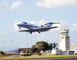
5 SAN JUAN/ISLA GRANDE - TJIG (SIG) Fernando L. Ribas Dominicci Commonly known as Isla Grande Airport, this is a small facility in Miramar, a district in the municipality of San Juan. It s convenient location within the convention center makes Isla Grande Airport an important part of the Puerto Rico Convention District, highlighting its centrality to the corporate and elite markets. ATIS: APC/DPC: E 119.4W TWR: GRND:121.7 CTAF: General Aviation, commercial and charter regional pasenger flilghts, regional cargo, Convention District support, aviation schools, aircraft maintenance. Coordinates N W AOE Status Public & Civil-open 24 hours, but Tower from 7:00 AM-7:00PM, Terminal open 6:00AM-7:30 PM Lights RWY, TWY, beacon. Beacon is off field S on a tower, MIRL Parking Tie-downs, hangar space at FBOs Left; Helicopters: right closed traffic Windsock N of approach-end of 9, one N 1000 RWY 9 Caution Cranes, buildings, cruise ships and birds Customs/Immigration 10:00 AM-7:30 PM, 7 days a week, west end of terminal bldg. One hr notification required , 8:00 AM-10:00 PM USDA Transportation Car rentals available at FBO s Main Terminal Car rental agencies at Int l airport. Taxis readily available. Airport Manager , X-3331, ARFF Ops , X-3332, Fax /27 5,542 x 100 Elevation: 10' LL Jet A FBOs- Fixed Based Operators Signature Flight Support Fuel sale, aircraft parking, charter flights, hotel reservations, car rentals, catering and ground handling. NorthShore Aviation Aircraft rental Million Air Aircraft management services, maintenance, fuel sale, ground handling, aircraft parking, avionics repair station, charter flights, aircraft paint, car rentals, catering, ground handling and aircraft rental. Ecolift Helicopter refurbish center, Certified Bell Helicopter Service Center, helicopter sale, helicopter spare parts sale, avionics installation and preventive maintenance (ATCT) Bacardi Rum Distillery Km. 6.2, Rte. 165, Cataño Carolina Public Beach/Isla Verde Km. 3.9 Rd. 187 El Morro Fortress End of Norzagaray Street Escambron Public Beach Puerta de Tierra Museo de Arte de Puerto Rico 299 De Diego Ave., Santurce Plaza Las Américas Chardon and Roosevelt Ave Rio Piedras Botanical Garden Rte. 1 and Rd. 847, Rio Piedras PUERTO RICO TOURISM COMPANY Old San Juan rmation Center , Exts. 3901,3902,3904,3905 Mon-Sun / 9:00 am -7:00 pm Threshold RWY 9 is 6.6 DME from San Juan VOR (308 radial) FSS San Juan Radio 122.2, 126.7, Flight Watch 122.0, 1(800)WX-BRIEF. San Juan Center East , West , 135.7, Close Flight Plan in air on 122.2


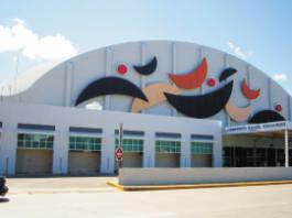
6 CONVENTION CENTER DISTRICT Fly, Land & Meet! Corporate Meeting Package Land at the Isla Grande Airport in San Juan, Puerto Rico and receive Free rental, Free Wi-Fi, Free Parking and a 10% Discount on all Food & Beverage PARTY SUITE Enjoy your favorite show in the comfort of a Party Suite. With 40 tickets included, reward your employees, delight clients or have fun with friends and family in the ultimate form of luxury the Coliseo offers to you. A party suite rental includes: 40 VIP tickets for the suite Personalized service Option of catering Double balcony PRIVATE EVENTS The Coliseo can be the stage for your next activity. Now you can make your private activity at the most important stage of the island: the Coliseo de Puerto Rico. We have different areas to make your celebration a success. Our packages range from a varied menu, security, bartenders, waiters, basic décor to audio-visual equipment, among others. For more information please contact us at BAHIA URBANA & AMPHITHEATRE


7 ARECIBO - TJAB (ABO) Antonio ( Nery) Juarbe Pol This airport has a large number of LSA ( Light Sport Aircraft) and Ultralights. It has become the main center of Sport Aviation in Puerto Rico. The airport is very popular with skydiving having a private school and parachute and Ultra lights activity. General aviation, events and development of commercial concessions Coordinates 18 27'N W Status Public. Attended 07:30-16:00 Local Windsock One mid-field Lights Runway, MIRL Landing Fees Apply to all Aircraft and Rotocraft Parking Tie down available Windsock Caution Airport Manager Arecibo Light House & Historical Park Islote, Arecibo 787- La Cueva del Indio Rd. 681, Km 8.0. National Astronomy and Ionosphere Center Largest radiotelescope in the world End of Rd Rio Camuy Cave Park Rte. 129, Lares PUERTO RICO TOURISM COMPANY Old San Juan rmation Center , Exts. 3901,3902,3904,3905 Mon-Sun / 9:00 am -7:00 pm CTAF: VOR: BQN MAZ 8/26 3,975 x 60 Elevation: 23' No Nav Aids FSS , FSS San Juan 122.2/126.7 (800) WX-BRIEF8


8 PONCE - TJPS (PSE) Mercedita Certified airport located three nautical miles east of the central business district of Ponce. It was originally and airfield used from 1939 for aerial irrigation of the reedbeds of the Serrallés companies. Later, it was converted into a military airport and in 1947 it was transferred to the Ports Authority by the United States Navy. Coordinates Limited cargo, Puerto de las Americas suport, commercial and charter passenger flights, development of commercial concessions N 'W AOE prior arrangement Status Public, 24 hrs Lights HIRL, REIL, PAPI, beacon Parking Windsock Caution Small hill and tower on final Rwy 12 Fuel Avgas 100LL, JetA1, east of terminal, on Airport of Entry Monday-Saturday, regular business hours. Custom/Immigration 1 hour notification required with prior apporval only , UDSA Transportation Taxis, carn rentals: Hertz, Avis, Budget, L&M, Thrifty Repairs South PR Aeroservice FBOs- Fixed Based Operators South AeroService Fuel sale and dispatch, aircraft maintenance, flight operations services, ground handling, catering, aircraft parking, hotel reservations, car rental, ground transportation and tours. For tourism information: Mon-Fri 8:00am-4:30pm Museo de Arte de Ponce Internationally renowned collection Las Americas Ave. El Museo Castillo Serralles Spanish Revival mansion from 1930 Caja de Muertos Island Nature Reserve Ferry Service from La Guancha Hacienda Buena Vista th-century coffee plantation and hacienda Km 16.8, Rd 123 La Guancha Boardwalk & Beach area End of Rte Tibes Indian Ceremonial Center 1,500-year old Taino village Parque de Bombas YES APC/DPC: CTAF:122.7 VOR: PSE SJ Center: /30 6,904 x 150 Elevation: LL Jet A1 24/ /7 METAR PSE San Juan Miami Radio

, aircraft rescue training base, aviation history/museum, maintenance base for airlines,")

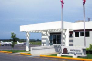
9 AGUADILLA TJBQ (BQN) Rafael Hernández International (Borinquen) Ex-military facility located in the northwest coast, 75 miles of San Juan. This is the principal of nine regional airports administered by the Puerto Rico Ports Authority. Passenger terminal ramp has a capacity to process up to three commercial airliners simultaneously. YES ATIS: APC/DPC: TWR: GRND: CTAF: VOR: BQN Cargo, commercial passenger flights, free trade zone, base for federal agencies (USCBP, USCG and USDA), aircraft rescue training base, aviation history/museum, maintenance base for airlines, development of commercial concessions. Coordinates 18 30'N W AOE Status Public & Civil open 24 hours, but Tower from 7:00AM-9:00PM; Overtime available upon request Lights HIRL, REILO, PAPI Parking Prepaid in advance for aircraft equal to or under 2,800 lbs. MAGTOW. Tie-downs, hangar space at Copeca Jet Center Left Airport of Entry 24 hrs Customs/ Immigration Customs , :00 a.m.- 8:00 p.m. USDA hours 8:00 a.m. 4:30 p.m., overtime is after hrs, plus Sat., Sun. & holidays, USDA , all during normal hours. Need 24 hr notice for overtime. Overtime fees: M-F after hrs. - $204, Sat, Sun. Holidays - $236. Immigration Off hours clearances must be coordinated with USDA Transportation Enterprise, Budget, Avis, Hertz, Dollar, Thrifty & Allied Repair Aeromech , Fax Settlement 3 miles NE of Aguadilla Airport Manager /26 11,702 x 200 / concrete Over time TWR OPS available on request 100LL Jet A1 24/ FBO- Fixed Based Operator COPECA Jet Center Fuel sale, catering, ground handling, aircraft parking, WiFi access, transportation services, car rentals, events logistic, lodging and VIP services. Western Aviation Services Corp Fuel sale, ground handling, aircraft parking, car rentals, transportation services, lodging, catering, aircraft maintenance, flight operations services, WiFi access and VIP services. Fortune Group Aircraft parking and tie-down, aircraft rental, maintenance, fuel sale, catering service, customer service such as hotel and restaurant reservations, ground transport and tours. Professional Ground Handling Services Fuel sale and dispatch, oil sale, ground handling services, aircraft parking and ground transportation services. 24/7 (AWOS) AGUADILLA Aguadilla Bowling Alley Rd 2 Km. 129 Aguadilla Ice Skating Arena Yumet Avenue (Rd 442) Crashboat Beach End of Rd 458, off Rd 107 Las Cascadas Water Park Km , Rte 2 Punta Borinquen Golf Club ISABELA Guajataca Forest Rd / PUERTO RICO TOURISM COMPANY Rafael Hernandez International Airport rmation Center , Ext. 1702, 1703 Mon-Sun / 8:00-12:00 m & 1:00-4:30 pm
. It was a military airport and serves general aviation since 1947. The airport is named after the celebrated Mayaguez native Eugenio Maria de Hostos.")


10 MAYAGUEZ - TJMZ (MAZ) Eugenio María de Hostos Is a small public airport located three nautical miles (6 km) north of the central business district of Mayaguez in an area of 172 acres (70 ha). It was a military airport and serves general aviation since The airport is named after the celebrated Mayaguez native Eugenio Maria de Hostos. General aviation and connecting service to SJU. Aeronautical Education, Tourism Coordinates 18 15'N 'W Status Public, 07:30-19:00 Lights Runway, taxi, beacon and PAPI, REIL Landing Fees Apply to all Aircraft and Rotorcraft Parking Tie Downs available Caution land rising to the S & E. Land north of town settlement. Windsock One E and wind tee mid-field Caution Mountains (East). Wires near approach to Runway , UDSA Transportation Taxis, car rental: Thrifty. Some hotels pick up. Settlement Airport located north of the town center. Airport manager , Fax Tropical Agriculture Research Station Yaguez Theater Parque Del Litoral Site for festivals and cultural activities Mayaguez Zoo Only large-scale zoo in the island APC/DPC: CTAF: VOR/DME: MAZ Clearance: /27 4,999 x 100 Elevation: 29' Nav Aids: San Juan Radar for IFR non-precision approach FSS: , FSS: 122.2, 126.7, RCO 122.1R/110.6T S.J. IFSS (800) WX-BRIEF For tourism information: Mon-Sun 8:00am-4:30pm


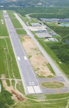
11 CEIBA - TJRV (RVR) José Aponte De la Torre (Formerly Roosevelt roads Military Base) Roosevelt Roads Naval Station is a former US Navy Base. Since November 2008, Puerto Rico Ports Authority operates this airport. It has an 11,000 foot long track x 150 wide, the second longest in the Caribbean, after the track of Aguadilla airport. General aviation, commercial and charter regional passenger flights, aeronautical education, regional cargo, aeronautical maintenance and commercial development of business assets including events. Luquillo/La Monserrate Beach Km 35.4, Rte. 3, Luquillo Las Cabezas de San Juan Natures Reserve Rd. 987, Las Croabas, Fajardo El Yunque National Forest Rd. 191, Rio Grande Punta Tuna Lighthouse Km. 3, Rd. 760, Maunabo Coordinates 18 14'N 'W AOE Status Lights Fuel Parking Tower Customs/Immigration Public, Attended 6:00 am-6:30 pm REIL, PAPI, Beacon Jet A, 100LL, Million Air Truck only, no facility Tie down available , Next to Terminal Transportation Taxis, Avis is just outside the gates; Thrifty is at the Marina, a short drive Airport Manager attended Remarks Rwy 18/36 closed. Right traffic Rwy 7 is downhill. Settlement: 2 miles FBOs- Fixed Based Operators PUERTO RICO TOURISM COMPANY Old San Juan rmation Center , Exts. 3901,3902,3904,3905 Mon-Sun / 9:00 am -7:00 pm APC/DPC: CTAF: SJ Center: /25 11,000 x 150 /concrete Elevation: 38' 100LL Jet A METAR

 Private tours available Sun Bay Beach (Camping Permitted) Off Rd.")

 is closed. Runway downhill W to E10 PUERTO RICO TOURISM COMPANY Vieques rmation Center 787-741-0800, 787-721-2400 Ext.")
12 VIEQUES - TJVQ (VQS) Antonio Rivera Rodríguez Certified airport located 7 miles to the West of the city Isabel II, in Vieques. Built by the US Army for military purposes during World War II, it was transferred to the Puerto Rico Ports Authority on May 15, 1947, following the conclusion of the war. Named after Don Antonio Rivera Rodríguez, former Vieques Mayor for 24 years. General aviation and commercial and cahrter regional passenger flights. Development of commercial concessions and tourism. Mosquito Bay (Bioluminescent Bay) Private tours available Sun Bay Beach (Camping Permitted) Off Rd. 997, near Esperanza Caracas Beach Coordinates 18 00N 'W Status Public, Fuel Avgas100LL, JetA, Million Air, Airport of Entry For aircraft entering from St. Croix or St. Thomas, call ahead at least 1hr. Call ahead for authorization if entering from other island. Custom/Immigration Located in terminal building Transportation Taxis, mini-bus, car rentals Fees Aircraft over 7500 lbs Airport Manager , Fax Remarks MCAS Camp Garcia (SE) is closed. Runway downhill W to E10 PUERTO RICO TOURISM COMPANY Vieques rmation Center , Ext Mon-Sun / 8:00-12:00 m & 1:00-4:30 pm YES APC/DPC: CTAF: VOR/DME: STT 9/27 4,300 x 75 Elevation: 49' None FSS San Juan 122.2, (800) WX-BRIEF, IFSS SJ


13 CULEBRA - TJCP (CPX) Benjamín Rivera Noriega In 1965, the government of Puerto Rico started flying civilians from San Juan to this municipality island with a Legislative compensation. In 1980, it was transferred to the Ports Authority. A new passenger terminal was built in The airport was designated after Benjamin Rivera Noriega, a pilot who earned the admiration of locals for his service and dedication. General aviation and commercial and charter regional passenger flights, development of commercial concessions. Coordinates 18 19N 'W AOE Status Public, Attended Caution Land Rwy 31, weather and wind permitting. Or, land Rwy 13, hill on final to the East. Stay right through the pass over the road dogleg final. Come in high and slow, runway is downhill. Custom/Immigration , customs Fax Transportation Rental Cars in Airport Airport Manager , Fax Remarks Attended 7:00 am-7:00 am. Closed SS-SR Beaches Brava Beach Carlos Rosario Beach Culebrita Flamenco Beach Tamarindo Beach Zoni Beach Museum of History Culebra Public Library PUERTO RICO TOURISM COMPANY Culebra rmation Center , Ext Mon-Sun / 8:00-12:00 m & 1:00-4:30 pm CTAF: /31 2,600 x 50 Elevation: 49' FSS (800) WX-BRIEF IFSS (SJ) None


14 HUMACAO - HUC (X63) A public airport located at the southeast coast of Puerto Rico. Use for recreational ultra light aircraft flights and private flights. Established in the grounds of a sugar industry in the 1960 s. In 1991, the Puerto Rico Ports Authority built a passenger terminal. Coordinates General aviation and development of commercial concessions. 18 9N 'W Status Public Lights MIRL Caution Aircraft fly a North pattern at 1,000 Ultralights fly a South pattern at 500 Obstructions Rwy 10-tree, mountain Airport Manager , Fax Remarks Attended Ultralight and parachute activity Punta Santiago Nature Reserve / Rancho Buena Vista Horseback Riding Stables Palmas Del Mar Golf Club Punta Tuna Lighthouse Km. 3, Rd 760, Maunabo PUERTO RICO TOURISM COMPANY Old San Juan rmation Center , Exts. 3901,3902,3904,3905 Mon-Sun / 9:00 am -7:00 pm CTAF: VOR: SJU 10/28 2,450 x 60 Elevation: 33' FSS 122.2, Phone (800) WX-BRIEF, IFSS (SJ) None
15 PRPA Airports Rates & Tariffs ISLA GRANDE AGUADILLA & PONCE CEIBA ALL OTHER REGIONAL AIRPORTS Passenger Terminal Space Rental: - per square foot year - air conditioner $ $ $ $ non air conditioner $ $ $ $ Passenger Fee: - per passenger - local $ 0.96 $ 0.85 $ 0.74 $ domestic $ 0.96 $ 0.85 $ 0.74 $ international $ 1.38 $ 0.85 $ 0.74 $ 0.55 Landing Fees (ALL AIRCRAFT OVER 7,500 MAGTOW): - per 1,000 lbs. MAGTOW $ 2.48 $ 0.93 $ 0.81 $ minimum per landing $ 6.20 $ 9.00 $ 9.00 $ 7.00 Landing Fees (Commercial aircraft equal to or under 7,500 MAGTOW): - per 1,000 lbs. MAGTOW $ 2.48 $ 0.93 $ 0.81 $ minimum per landing $ 6.20 $ 9.00 $ 9.00 $ 1.00 Aircraft Parking Rates Paved Areas: - daily (per 1,000 lbs. MAGTOW) $ 0.50 $ 0.58 $ 0.50 $ daily minimum $ 3.50 $ 4.00 $ 3.50 $ monthly minimum (PRPA registered aricrafts only) $ $ $ $ Aircraft Parking Rates Unpaved Areas: - daily (per 1,000 lbs. MAGTOW) n/a $ 0.58 $ 0.50 $ daily minimum n/a $ 4.00 $ 3.50 $ monthly minimum (PRPA registered aricrafts only) n/a $ $ $ Ground Rental (square foot per year) $ 1.29 $ 0.55 $ 0.55 $ 0.55 Warehouse Rental: - per square foot yaer $ 3.86 $ 1.75 $ 1.75 $ 1.75 Hangar Rental (per foot per year) $ 3.86 $ 1.75 $ 1.75 $ 1.75

16 Rolando J. Torres-Carrión Executive Director , Ext Rolando Padua-Meléndez Aviation Bureau Director Irene Rocafort-Lugo New Business and Air Access , Ext PUERTO RICO PORTS
Jax Navy Flying Club Course Rules
 Jax Navy Flying Club Course Rules Responsibilities. The Jax Navy Flying Club maintains responsibility for ensuring that all pilots operating out of Naval Air Station Jacksonville are familiar with local
(No. 186) (Approved August 17, 2011) AN ACT
 (Approved August 17, 2011) AN ACT") (H. B. 1210) (No. 186) (Approved August 17, 2011) AN ACT To add a Section 1(B) to Act No. 168 of May 4, 1949, as amended, in order to require enclosed shopping malls with retail space greater than one
(H. B. 1210) (No. 186) (Approved August 17, 2011) AN ACT To add a Section 1(B) to Act No. 168 of May 4, 1949, as amended, in order to require enclosed shopping malls with retail space greater than one
H O M E C O M I N G. NOTAM Aircraft Owners and Pilots Association (AOPA) Fly-In Frederick Municipal Airport (FDK) Frederick, MD
 Fly-In Frederick Municipal Airport (FDK) Frederick, MD") F L Y - I N AOPA H O M E C O M I N G FREDERICK, MD NOTAM Aircraft Owners and Pilots Association (AOPA) Fly-In Frederick Municipal Airport (FDK) Frederick, MD SPECIAL FLIGHT PROCEDURES EFFECTIVE 1200 NOON
F L Y - I N AOPA H O M E C O M I N G FREDERICK, MD NOTAM Aircraft Owners and Pilots Association (AOPA) Fly-In Frederick Municipal Airport (FDK) Frederick, MD SPECIAL FLIGHT PROCEDURES EFFECTIVE 1200 NOON
JACK EDWARDS NATIONAL AIRPORT (JKA) GULF SHORES, AL
 GULF SHORES, AL") OCTOBER 26-27, 2018 JACK EDWARDS NATIONAL AIRPORT (JKA) GULF SHORES, AL SPECIAL FLIGHT PROCEDURES EFFECTIVE: Thursday Oct 25, 2018 12:00 NOON CDT until 6:00 PM CDT Friday Oct 26, 2018 7:00 AM CDT until
OCTOBER 26-27, 2018 JACK EDWARDS NATIONAL AIRPORT (JKA) GULF SHORES, AL SPECIAL FLIGHT PROCEDURES EFFECTIVE: Thursday Oct 25, 2018 12:00 NOON CDT until 6:00 PM CDT Friday Oct 26, 2018 7:00 AM CDT until
International Airlines Safety Concerns in the Caribbean region.
 International Airlines Safety Concerns in the Caribbean region. Brian Gonzalez Air Traffic Systems Manager American Airlines MIA Brian.Gonzalez@AA.com Executive Summary Air traffic in ZMA Oceanic and ZSU
CHICAGOLAND SPEEDWAY NASCAR RACES
 CHICAGOLAND SPEEDWAY NASCAR RACES JUNE 28 THROUGH JULY 2, 2018 In anticipation of a significant number of aircraft traveling to the Chicago, Illinois, area during the Chicagoland Speedway NASCAR races,
SANTA FE MUNICIPAL AIRPORT (SAF) SANTA FE, NM
 SANTA FE, NM") SEPTEMBER 13-15, 2018 SANTA FE MUNICIPAL AIRPORT (SAF) SANTA FE, NM SPECIAL FLIGHT PROCEDURES EFFECTIVE: Thursday Sept 13, 2018 12:00 NOON MDT until 7:00 PM MDT Friday Sept 14, 2018 7:00 AM MDT until 7:00
SEPTEMBER 13-15, 2018 SANTA FE MUNICIPAL AIRPORT (SAF) SANTA FE, NM SPECIAL FLIGHT PROCEDURES EFFECTIVE: Thursday Sept 13, 2018 12:00 NOON MDT until 7:00 PM MDT Friday Sept 14, 2018 7:00 AM MDT until 7:00
PILOT INFORMATION PACKET
 PILOT INFORMATION PACKET Including Special Flight Procedures Indianapolis, IN May 31, 2014 AOPA FLY-IN HOST FBO: The AOPA Fly-in Host FBO at Indianapolis Regional Airport is Indy Jet. We thank them for
Jax Navy Flying Club Course Rules
 Jax Navy Flying Club Course Rules Responsibilities. The Jax Navy Flying Club maintains responsibility for ensuring that all pilots operating out of Naval Air Station Jacksonville are familiar with local
1.1.3 Taxiways. Figure 1-15: Taxiway Data. DRAFT Inventory TYPICAL PAVEMENT CROSS-SECTION LIGHTING TYPE LENGTH (FEET) WIDTH (FEET) LIGHTING CONDITION
 WIDTH (FEET) LIGHTING CONDITION") 1.1.3 Taxiways EWN has an extensive network of taxiways and taxilanes connecting the terminal, air cargo, and general aviation areas with the runways as listed in Figure 1-15. A 50-foot wide parallel taxiway
1.1.3 Taxiways EWN has an extensive network of taxiways and taxilanes connecting the terminal, air cargo, and general aviation areas with the runways as listed in Figure 1-15. A 50-foot wide parallel taxiway
September 29, resilience360.com
 September 29, 2017 resilience360.com resilience360@dhl.com 2 DHL RESILIENCE360 SPECIAL BRIEF Hurricane Maria made landfall in Puerto Rico on September 20, causing severe damage to the country s infrastructure,
TAKE-OFF MINIMUMS AND (OBSTACLE) DEPARTURE PROCEDURES
 DEPARTURE PROCEDURES") C1 INSTRUMENT APPROACH PROCEDURE CHARTS IFR Civil Airports and Selected Military Airports ALL USERS: Airports that have Departure Procedures (DPs) designed specifically to assist pilots in avoiding obstacles
C1 INSTRUMENT APPROACH PROCEDURE CHARTS IFR Civil Airports and Selected Military Airports ALL USERS: Airports that have Departure Procedures (DPs) designed specifically to assist pilots in avoiding obstacles
AOPA FLY-IN PACKET EFFECTIVE SPECIAL FLIGHT PROCEDURES SEPT BATTLE CREEK, MI W K KELLOGG AIRPORT (KBTL) PILOT INFORMATION
 PILOT INFORMATION") AOPA FLY-IN W K KELLOGG AIRPORT (KBTL) PILOT INFORMATION PACKET SEPT 16-17 BATTLE CREEK, MI SPECIAL FLIGHT PROCEDURES EFFECTIVE 12:00 Noon EDT until 6:00PM EDT Friday, September 16 and 7:00AM EDT until
AOPA FLY-IN W K KELLOGG AIRPORT (KBTL) PILOT INFORMATION PACKET SEPT 16-17 BATTLE CREEK, MI SPECIAL FLIGHT PROCEDURES EFFECTIVE 12:00 Noon EDT until 6:00PM EDT Friday, September 16 and 7:00AM EDT until
AOPA FLY-IN PACKET EFFECTIVE PILOT INFORMATION SPECIAL FLIGHT PROCEDURES MAY BEAUFORT, NC
 AOPA FLY-IN PILOT INFORMATION PACKET MAY 20-21 BEAUFORT, NC SPECIAL FLIGHT PROCEDURES EFFECTIVE 12:00 Noon EDT Until 8:00PM EDT Friday, May 20, 2016 and 6:00AM EDT Until 8:00PM EDT Saturday, May 21, 2016
CHICAGOLAND SPEEDWAY NASCAR RACES
 CHICAGOLAND SPEEDWAY NASCAR RACES SEPTEMBER 15 THROUGH SEPTEMBER 19, 2016 In anticipation of a significant number of aircraft traveling to the Chicago, Illinois, area during the Chicagoland Speedway NASCAR
National Transportation Safety Board Aviation Accident Final Report
 National Transportation Safety Board Aviation Accident Final Report Location: Isla De Vieques, PR Accident Number: Date & Time: 06/20/2002, 1620 EST Registration: N786DM Aircraft: Cessna 208B Aircraft
NOTAM. Aircraft Owners and Pilots Association (AOPA) Fly-In Colorado Springs Airport (COS) Colorado Springs, CO SPECIAL FLIGHT PROCEDURES
 Fly-In Colorado Springs Airport (COS) Colorado Springs, CO SPECIAL FLIGHT PROCEDURES") NOTAM Aircraft Owners and Pilots Association (AOPA) Fly-In Colorado Springs Airport (COS) Colorado Springs, CO SPECIAL FLIGHT PROCEDURES EFFECTIVE 12:00 Noon Local Friday, September 25, 2015 Until 6:00
NOTAM Aircraft Owners and Pilots Association (AOPA) Fly-In Colorado Springs Airport (COS) Colorado Springs, CO SPECIAL FLIGHT PROCEDURES EFFECTIVE 12:00 Noon Local Friday, September 25, 2015 Until 6:00
PILOT INFORMATION PACKET
 PILOT INFORMATION PACKET Aircraft Owners and Pilots Association (AOPA) Fly-In Colorado Springs Airport (COS) Colorado Springs, CO SPECIAL FLIGHT PROCEDURES EFFECTIVE 12:00 Noon Local Friday, September
Glossary. Part I Acronyms/Data Terminology. AIFSS -- Automated International Flight Service Station.
 Glossary Part I Acronyms/Data Terminology AC -- Air Carrier. AFSS -- Automated Flight Service Station. AIFSS -- Automated International Flight Service Station. ARTCC -- Air Route Traffic Control Center.
Burlington ATCT Standard Operating Procedures
 This air traffic control procedural document is provided for virtual air traffic control in the ZBW ARTCC of the VATSIM network only. It is not for real-world ATC use. These procedures are approved for
Whitsunday Airport. The pilot s gateway in the heart of the Whitsundays. Visiting Pilot s Guide
 Whitsunday Airport The pilot s gateway in the heart of the Whitsundays Visiting Pilot s Guide Airport Statistics & Services ERSA Reference: Situation: Elevation: Shute Harbour/Whitsunday. Lat 20 o 16 S
PILOT INFORMATION PACKET
 PILOT INFORMATION PACKET Aircraft Owners and Pilots Association (AOPA) Fly-In Tullahoma Regional Airport (THA) Tullahoma, TN SPECIAL FLIGHT PROCEDURES EFFECTIVE 12:00 Noon CDT Until 6:00PM CDT Friday,
LIHTC Properties in Puerto Rico through 2015
 LIHTC Properties in Puerto Rico through 2015 nprofit PIS ALAMEDA II 4 CARR 21 SAN JUAN PR 1988 t Indicated 1988 Acquisition and Rehab 150 150 ALAMEDA TOWER III SAN JUAN PR 1989 $533,862 1989 Acquisition
F L Y - I N AOPA NOTAM. Aircraft Owners and Pilots Association (AOPA) Fly-In Salinas Municipal Airport (SNS) Salinas, CA SPECIAL FLIGHT PROCEDURES
 Fly-In Salinas Municipal Airport (SNS) Salinas, CA SPECIAL FLIGHT PROCEDURES") F L Y - I N AOPA SALINAS, CA NOTAM Aircraft Owners and Pilots Association (AOPA) Fly-In Salinas Municipal Airport (SNS) Salinas, CA SPECIAL FLIGHT PROCEDURES EFFECTIVE 1200 NOON local Friday, May 15, 2015
F L Y - I N AOPA SALINAS, CA NOTAM Aircraft Owners and Pilots Association (AOPA) Fly-In Salinas Municipal Airport (SNS) Salinas, CA SPECIAL FLIGHT PROCEDURES EFFECTIVE 1200 NOON local Friday, May 15, 2015
NOTAM AIRCRAFT OWNERS AND PILOTS ASSOCIATION (AOPA) FLY-IN CHINO AIRPORT (CNO) CHINO, CALIFORNIA
 FLY-IN CHINO AIRPORT (CNO) CHINO, CALIFORNIA") NOTAM AIRCRAFT OWNERS AND PILOTS ASSOCIATION (AOPA) FLY-IN CHINO AIRPORT (CNO) CHINO, CALIFORNIA EFFECTIVE 12:00 NOON LOCAL FRIDAY, SEPTEMBER 19, 2014 UNTIL 6:00 PM LOCAL SATURDAY, SEPTEMBER 20, 2014 TEMPORARY
NOTAM AIRCRAFT OWNERS AND PILOTS ASSOCIATION (AOPA) FLY-IN CHINO AIRPORT (CNO) CHINO, CALIFORNIA EFFECTIVE 12:00 NOON LOCAL FRIDAY, SEPTEMBER 19, 2014 UNTIL 6:00 PM LOCAL SATURDAY, SEPTEMBER 20, 2014 TEMPORARY
AOPA FLY-IN PACKET EFFECTIVE PILOT INFORMATION SPECIAL FLIGHT PROCEDURES SEPT 30-OCT 1 PRESCOTT, AZ ERNEST A LOVE FIELD AIRPORT (PRC)
") AOPA FLY-IN ERNEST A LOVE FIELD AIRPORT (PRC) PILOT INFORMATION PACKET SEPT 30-OCT 1 PRESCOTT, AZ SPECIAL FLIGHT PROCEDURES EFFECTIVE 12:00 Noon MST until 6:00 PM MST Friday, September 30, 2016 7:00 AM
AOPA FLY-IN ERNEST A LOVE FIELD AIRPORT (PRC) PILOT INFORMATION PACKET SEPT 30-OCT 1 PRESCOTT, AZ SPECIAL FLIGHT PROCEDURES EFFECTIVE 12:00 Noon MST until 6:00 PM MST Friday, September 30, 2016 7:00 AM
Pilot Information Packet
 Pilot Information Packet Including Special Flight Procedures Chino, CA September 20, 2014 Airworthy using the most detailed, historically accurate and talented restorationists in the world. Welcome to
Jeppesen Mobile FliteDeck VFR
 Airport Information CLEARWATER INTL (PIE) 10 Rwy9730 118.30 CTAF Location Name Fuel and Services Available Identifier Length of longest runway Frequency (public airports only) Airport Elevation 118.60
EVTA AD 2.1 AERODROME LOCATION INDICATOR AND NAME EVTA AD 2.2 AERODROME GEOGRAPHICAL AND ADMINISTRATIVE DATA
 18 NOV 2010 AIP LATVIA EVTA AD 2-1 18 NOV 2010 Note: The following sections in this chapter are intentionally left blank: AD-2.11, AD-2.14, AD-2.15, AD-2.16, AD- 2.19, AD-2.20, AD-2.21, AD-2.23 EVTA AD
2014 NOTAM Special Flight Procedures. Indianapolis, IN Effective 0600 EDST (Local) May 30, 2014 Until 2000 EDST (Local) May 31, 2014
 May 30, 2014 Until 2000 EDST (Local) May 31, 2014") 2014 NOTAM Special Flight Procedures Indianapolis, IN Effective 0600 EDST (Local) May 30, 2014 Until 2000 EDST (Local) May 31, 2014 AIRCRAFT OWNERS AND PILOTS ASSOCIATION (AOPA) FLY-IN INDIANAPOLIS, IN
2014 NOTAM Special Flight Procedures Indianapolis, IN Effective 0600 EDST (Local) May 30, 2014 Until 2000 EDST (Local) May 31, 2014 AIRCRAFT OWNERS AND PILOTS ASSOCIATION (AOPA) FLY-IN INDIANAPOLIS, IN
Appendix K: MSP Class B Airspace
 Appendix K: MSP Class B Airspace K All of the open sky covering the United States, from less than an inch off the ground all the way to outer space, is part of America s airspace. This airspace resource
Special Aircraft Arrival and Departure Procedures in Effect Noon Wednesday, Nov 4 th through Noon Sunday, Nov 8 th AREA OVERVIEW
 Special Aircraft Arrival and Departure Procedures in Effect Noon Wednesday, Nov 4 th through Noon Sunday, Nov 8 th AREA OVERVIEW AOPA is proud to present the 2009 Aviation Summit in Tampa Florida. This
EFFECTIVE KTPF 10/27 SPECIAL FLIGHT PROCEDURES PILOT INFORMATION PACKET TAMPA, FL
 KTPF PETER O. KNIGHT AIRPORT TAMPA, FL 17 10/27 10/28 PILOT INFORMATION PACKET SPECIAL FLIGHT PROCEDURES EFFECTIVE 12:00 Noon EDT until 7:00 PM EDT Thursday, October 26, 2017 7:00 AM EDT until 7:00 PM
TABLE OF CONTENTS. 3 Airport Managers Notice, Arlington Airport Closures. 4 Air Show Operations, Arlington Area Frequencies
 2 In anticipation of the large number of aircraft operating to and from Arlington Municipal Airport during the Arlington Fly-In, the following procedures will be used to enhance safety and minimize air
Teterboro Airport Overview
 Teterboro Airport Overview Teterboro Airport consists of two intersecting runways. Runway 6-24 is 6,013 ft long and 150 ft wide, and is equipped with High Intensity Runway Edge Lights (HIRL) and Runway
Fresno Area Mid-Air Collision Avoidance Program (MACA) California Air National Guard 144 th Fighter Wing, Fresno, CA
 California Air National Guard 144 th Fighter Wing, Fresno, CA") Fresno Area Mid-Air Collision Avoidance Program (MACA) California Air National Guard 144 th Fighter Wing, Fresno, CA As of March 2013 Mid-Air Collision Avoidance This briefing contains material that can
Fresno Area Mid-Air Collision Avoidance Program (MACA) California Air National Guard 144 th Fighter Wing, Fresno, CA As of March 2013 Mid-Air Collision Avoidance This briefing contains material that can
FEDERAL AVIATION ADMINISTRATION CENTRAL EN ROUTE AND OCEANIC AREA OPERATIONS FORT WORTH ARTC CENTER, MAJORS ATCT, AND SKYDIVE TANDEM GREENVILLE, LLC
 FEDERAL AVIATION ADMINISTRATION CENTRAL EN ROUTE AND OCEANIC AREA OPERATIONS FORT WORTH ARTC CENTER, MAJORS ATCT, AND SKYDIVE TANDEM GREENVILLE, LLC LETTER OF AGREEMENT Effective: April 10,2012 SUBJECT:
EFFECTIVE KGON 10/06 SPECIAL FLIGHT PROCEDURES PILOT INFORMATION PACKET GROTON, CT
 KGON GROTON-NEW LONDON AIRPORT GROTON, CT 17 10/06 10/07 PILOT INFORMATION PACKET SPECIAL FLIGHT PROCEDURES EFFECTIVE 12:00 Noon EDT until 6:00 PM EDT Thursday, October 5, 2017 7:00 AM EDT until 6:00 PM
Vertiport Chicago is a private facility, open to authorized users. Prior permission and/or landing reservations are required (PPR).
.") Heliport Information Vertiport Chicago is a private facility, open to authorized users. Prior permission and/or landing reservations are required (PPR). Location Identifier: 43IL Lat/Long: 41 51 47.3"N
Heliport Information Vertiport Chicago is a private facility, open to authorized users. Prior permission and/or landing reservations are required (PPR). Location Identifier: 43IL Lat/Long: 41 51 47.3"N
NAVIGATION: CHARTS, PUBLICATIONS, FLIGHT COMPUTERS (chapters 7 & 8)
") NAVIGATION: CHARTS, PUBLICATIONS, FLIGHT COMPUTERS (chapters 7 & 8) LONGITUDE AND LATITUDE 1. The location of an airport can be determined by the intersection of lines of latitude and longitude. a. Lines
NAVIGATION: CHARTS, PUBLICATIONS, FLIGHT COMPUTERS (chapters 7 & 8) LONGITUDE AND LATITUDE 1. The location of an airport can be determined by the intersection of lines of latitude and longitude. a. Lines
$9.68 PER HOUR STATE HOUSING WAGE
 PUERTO RICO STATE #2 * RANKING In Puerto Rico, the Fair Market Rent () for a two-bedroom apartment is $04. In order to afford this level of and utilities without paying more than of income on housing a
a. Aeronautical charts DID THIS IN LESSON 2
 AIRMAN CERTIFICATION STANDARDS: REMOTE PILOT SMALL: You will know and be able to explain in writing or oral form the below tasks regarding AIRPORT OPERATIONS Task References Objective Task B. Airport Operations
SPORT AVIATION CORP LTD
 SPORT AVIATION CORP LTD RECREATIONAL PILOT WRITTEN EXAMINATION Subcategory: Microlight No. 1 AIR LAW This examination paper remains the property of SAC Ltd and is protected by copyright. Name of Applicant:
Source: Chippewa Valley Regional Airport ASOS, Period of Record
 Chapter 1 Inventory Runway wind coverage is the percentage of time a runway can be used without exceeding allowable crosswind velocities. Allowable crosswind velocities vary depending on aircraft size
October 4, 5, 6, 2007 Aircraft Arrival and Departure Procedures
 October 4, 5, 6, 2007 Aircraft Arrival and Departure Procedures AREA OVERVIEW AOPA is proud to present the 2007 Expo in Hartford Connecticut. This is the first time that AOPA Expo has been held in the
EFFECTIVE NOTAM KOUN SPECIAL FLIGHT PROCEDURES 09/08 NORMAN, OK
 KOUN WESTHEIMER AIRPORT NORMAN, OK 17 09/08 09/09 NOTAM SPECIAL FLIGHT PROCEDURES EFFECTIVE 12:00 Noon CDT until 7:30 PM CDT Thursday, September 7, 2017 7:00 AM CDT until 7:30 PM CDT Friday, September
UNIVERSITY OF ALABAMA FOOTBALL
 UNIVERSITY OF FOOTBALL SPECIAL AIR TRAFFIC PROCEDURES TUSCALOOSA, AL September 16, 2017 November 18, 2017 The following procedures will be implemented to enhance safety and minimize delays during the following
$ FACTS ABOUT PUERTO RICO: WAGE HOUSING MOST EXPENSIVE AREAS WAGE RANKING
 STATE #52 * RANKING In Puerto Rico, the Fair Market Rent () for a two-bedroom apartment is $480. In order this level of and utilities without paying more than 30% of income on housing a household must
EFFECTIVE NOTAM KGON 10/06 SPECIAL FLIGHT PROCEDURES GROTON, CT
 KGON GROTON-NEW LONDON AIRPORT GROTON, CT 17 10/06 10/07 NOTAM SPECIAL FLIGHT PROCEDURES EFFECTIVE 12:00 Noon EDT until 6:00 PM EDT Thursday, October 5, 2017 7:00 AM EDT until 6:00 PM EDT Friday, October
AD 2. AERODROMES VAKS AD 2.2 AERODROME GEOGRAPHICAL AND ADMINISTRATIVE DATA
 AD 2-1 AD 2. AERODROMES AD 2.1 AERODROME LOCATION INDICATOR AND NAME - KESHOD / DOMESTIC AD 2.2 AERODROME GEOGRAPHICAL AND ADMINISTRATIVE DATA 1 Aerodrome reference point coordinates and its site 2 Direction
SOPs for Cedar Valley Airport UT10
 SOPs for Cedar Valley Airport UT10 Cedar Valley Airport is a privately owned airport located approximately 10 miles west of Lehi, Ut and 5 miles northeast of Cedar Fort, UT. The airport location is N40.3572
San Juan CERAP. Standard Operation Procedures. Version 2.2 May 5th, Welcome to San Juan CERAP (ZSU ARTCC, TJZS FIR)
") San Juan CERAP Standard Operation Procedures Version 2.2 May 5th, 2013 Welcome to San Juan CERAP (ZSU ARTCC, TJZS FIR) You are entering one of the most fascinating Combined Enroute Radar Approach Control
San Juan CERAP Standard Operation Procedures Version 2.2 May 5th, 2013 Welcome to San Juan CERAP (ZSU ARTCC, TJZS FIR) You are entering one of the most fascinating Combined Enroute Radar Approach Control
MISSOULA INTERNATIONAL AIRPORT (MSO) MISSOULA, MT
 MISSOULA, MT") JUNE 14-16, 2018 MISSOULA INTERNATIONAL AIRPORT (MSO) MISSOULA, MT SPECIAL FLIGHT PROCEDURES EFFECTIVE: Thursday June 14, 2018 12:00 NOON MDT until 7:30 PM MDT Friday June 15, 2018 6:00 AM MDT until 7:30
JUNE 14-16, 2018 MISSOULA INTERNATIONAL AIRPORT (MSO) MISSOULA, MT SPECIAL FLIGHT PROCEDURES EFFECTIVE: Thursday June 14, 2018 12:00 NOON MDT until 7:30 PM MDT Friday June 15, 2018 6:00 AM MDT until 7:30
 IFR 91.157 Must be instrument rated to fly special VFR at Night (civil twilight to civil twilight, sun 6 degrees below horizon) 91.159 Unless in a holding pattern of 2 minutes or less, VFR cruising altitude
BUSINESS OF THE CITY COUNCIL CITY OF MERCER ISLAND, WA
 BUSINESS OF THE CITY COUNCIL CITY OF MERCER ISLAND, WA AB 4564 September 7, 2010 Regular Business RENTON AIRPORT STATUS UPDATE Proposed Council Action: Receive update. No action required. DEPARTMENT OF
2014 NOTAM Special Flight Procedures. Plymouth, MA Effective 12:00 Noon (Local) July 11, 2014 Until 6:00PM (Local) July 12, 2014
 July 11, 2014 Until 6:00PM (Local) July 12, 2014") 2014 NOTAM Special Flight Procedures Plymouth, MA Effective 12:00 Noon (Local) July 11, 2014 Until 6:00PM (Local) July 12, 2014 AIRCRAFT OWNERS AND PILOTS ASSOCIATION (AOPA) FLY-IN PLYMOUTH, MASSACHUSETTS
2014 NOTAM Special Flight Procedures Plymouth, MA Effective 12:00 Noon (Local) July 11, 2014 Until 6:00PM (Local) July 12, 2014 AIRCRAFT OWNERS AND PILOTS ASSOCIATION (AOPA) FLY-IN PLYMOUTH, MASSACHUSETTS
Chapter 9 - Airspace: The Wild Blue, Green & Red Yonder
 I5 Class G Airspace 38. [I4/3/3] What minimum visibility and clearance from clouds are required for VFR operations in Class G airspace at 700 feet AGL or lower during daylight hours? A. mile visibility
Course Rules NAS Whiting Field Ops. Created: 27 Aug 11 Last Updated: 24 Nov 15
 Course Rules NAS Whiting Field Ops Created: 27 Aug 11 Last Updated: 24 Nov 15 Overview Airfield / General Information Ground Operations Takeoff / Departures Home Field Entry Landing / Parking References
AOPA FLY-IN NOTAM MAY BEAUFORT, NC SPECIAL FLIGHT PROCEDURES EFFECTIVE
 AOPA FLY-IN NOTAM MAY 20-21 BEAUFORT, NC SPECIAL FLIGHT PROCEDURES EFFECTIVE 12:00 Noon EDT Until 8:00PM EDT Friday, May 20, 2016 and 6:00AM EDT Until 8:00PM EDT Saturday, May 21, 2016 VFR ARRIVALS OVERVIEW
JEPPESEN JeppView General Info Surabaya, IDN S ' E ' Mag Var: 0.0 W Elevation: 9' Runway Info Runway ' x 148' asphalt
 Airport Information WARR (Juanda) General Info Surabaya, IN S 07 22.8' E112 47.2' Mag Var: 0.0 W Elevation: 9' Public, IFR, Control Tower, Rotating Beacon, Low Level Wind Shear Alert System, Customs Fuel:
NATIONAL BUSINESS AVIATION ASSOCIATION (NBAA) CONVENTION
 CONVENTION") National Business Aviation Association (NBAA) Convention Notices to Airmen NATIONAL BUSINESS AVIATION ASSOCIATION (NBAA) CONVENTION ORLANDO, October 16 18, 2018 SPECIAL AIR TRAFFIC PROCEDURES Special air
National Business Aviation Association (NBAA) Convention Notices to Airmen NATIONAL BUSINESS AVIATION ASSOCIATION (NBAA) CONVENTION ORLANDO, October 16 18, 2018 SPECIAL AIR TRAFFIC PROCEDURES Special air
East Hampton Airport (KHTO) Noise Abatement Plan 2016 Prepared by the Eastern Region Helicopter Council
 Noise Abatement Plan 2016 Prepared by the Eastern Region Helicopter Council") East Hampton Airport (KHTO) Noise Abatement Plan 2016 Prepared by the Eastern Region Helicopter Council DRAFT Original 1 The following presentation has been prepared by the Eastern Region Helicopter Council
East Hampton Airport (KHTO) Noise Abatement Plan 2016 Prepared by the Eastern Region Helicopter Council DRAFT Original 1 The following presentation has been prepared by the Eastern Region Helicopter Council
2012 Mat Su Valley Collision Avoidance Survey
 Table of Contents Table of Contents 1 INTRODUCTION Measurement Objectives 3 Methodology and Notes 4 Key Findings 5 PILOT LOCATION Activity in the Area 7 Pilot Location 8 Altitudes Flown 9 SAFETY IN THE
Scenario Training VGT - IWA
 Scenario Training VGT - IWA This lesson is divided into two separate scenario flights; KVGT to 61B, and KVGT to KIWA. The first flight to 61B will emphasize a DP out of KVGT and IFR operations into an
PREDANNACK AD LOCATION INDICATOR AND NAME PREDANNACK PREDANNACK AD AERODROME GEOGRAPHICAL AND ADMINISTRATIVE DATA. 2nm SE of Mullion.
 AD 2 - - 1-1 AD 2.1 - LOCATION INDICATOR AND NAME AD 2.2 - AERODROME GEOGRAPHICAL AND ADMINISTRATIVE DATA 1 ARP Co-ordinates and site at AD: 2 Direction and distance from City: 3 Elevation/Reference Temperature:
Stanfield VOR Procedures
 Stanfield VOR This PowerPoint is not intended as a directive. It is intended to serve as a tool to communicate the training community s best practices. Any questions or concerns to these procedures are
ATC PRACTICE. 20 miles South inbound landing Lincoln 22 miles SW inbound for the Denton. airport
 ATC PRACTICE Reading Back Making a request Initial Contact Squawk 0219 and ident Lincoln altimeter 2992 say altitude Radar contact 23 miles east of Lincoln proceed inbound left base for 35 say altitude
RWY 24. Designator Route Remarks. All traffic shall initially climb to 4000FT QNH with climb gradient 3.3% MNM, unless instructed otherwise by ATC.
 AD 2.ELLX-15 DISKI 2Y GTQ 7X GTQ 7Y MMD 7X RAPOR 4X 3.2.2 Climb Requirements RWY 24 Designator Route Remarks R-238 LUX to 8 DME LUX, RT to intercept R-222 NTM to 24 DME NTM, RT R-156 DIK, LT R-115 LUX
Cape Area Airports Standard Operating Procedures
 Cape Area Airports Standard Operating Procedures This air traffic control procedural document is provided for virtual air traffic control in the ZBW ARTCC of the VATSIM network only. It is not for real-world
FLIGHT ADVISORY NATIONAL SPECIAL SECURITY EVENT UNITED NATIONS GENERAL ASSEMBLY UNGA-67 SEPTEMBER 18, 2012 September 28, 2012
 FEDERAL AVIATION ADMINISTRATION FLIGHT ADVISORY NATIONAL SPECIAL SECURITY EVENT UNITED NATIONS GENERAL ASSEMBLY UNGA-67 SEPTEMBER 18, 2012 September 28, 2012 This advisory will serve as notice of flight
Contents. Subpart A General 91.1 Purpose... 7
 Contents Rule objective... 3 Extent of consultation... 3 Summary of comments... 4 Examination of comments... 6 Insertion of Amendments... 6 Effective date of rule... 6 Availability of rules... 6 Part 91
VFR Patterns on airport
 VFR Patterns on airport Left Traffic South Alpha Call Tower: Kona Tower, Helicopter, Requesting Left Traffic South Alpha Upwind - remain East of the KOA VOR climb to 300 MSL or higher Crosswind - remain
VFR Radio Communications
 VFR Radio Communications 25 Ready to Use Flashcards This Material Shall Not be Manipulated for Professional Sales or Personal Profit. All Rights Reserved, 2014, Mile High Flight Academy & Post House Studios,
ArcadiaMunicipalAirportislocatedonthesoutheast sideofarcadia,southofstateroute70,westofstate Route31,andisaccessiblefrom AirportRoad.
 Arcadia GeneralAviationAirport ArcadiaMunicipalAirportislocatedonthesoutheast sideofarcadia,southofstateroute70,westofstate Route31,andisaccessiblefrom AirportRoad.Arcadia islocatedapproximately30milesnortheastoftheport
EGSL ANDREWSFIELD EGSL AD 2.1 AERODROME LOCATION INDICATOR AND NAME EGSL AD 2.2 AERODROME GEOGRAPHICAL AND ADMINISTRATIVE DATA
 UNITED KINGDOM AIP AD 2.EGSL-1 26 May 2016 EGSL ANDREWSFIELD EGSL AD 2.1 AERODROME LOCATION INDICATOR AND NAME EGSL ANDREWSFIELD EGSL AD 2.2 AERODROME GEOGRAPHICAL AND ADMINISTRATIVE DATA 1 ARP coordinates
CEE 4674 Airport Planning and Design. Antonio A. Trani Julio Roa. Punta Cana Ecological Foundation Summer I, 2013
 CEE 4674 Airport Planning and Design Antonio A. Trani Julio Roa Punta Cana Ecological Foundation Summer I, 2013 CEE 4674 - Course Information CEE This course is oriented to those engineering students who
Effective: AUSTRALIAN INTERNATIONAL AIRSHOW AVALON 2019, AVALON AIRPORT 19 FEBRUARY - 5 MARCH 2019, IFR OPERATIONS AVALON AIRPORT
 AUSTRALIA AERONAUTICAL INFORMATION SERVICE AIRSERVICES AUSTRALIA GPO BOX 367, CANBERRA ACT 2601 Phone: 02 6268 4874 Email: aim.editorial@airservicesaustralia.com Effective: AIP SUPPLEMENT (SUP) H 02/19
October 10, Michael Moriarty Mitigation Division Director FEMA Region II
 U. S. Department of Homeland Security Region II One World Trade Center, 52nd Floor New York, NY 10007 October 10, 2017 MEMORANDUM FOR: Alejandro De La Campa Federal Coordinating Officer FEMA-4339-DR &
Ms Chris Hulet, Tower Chief
 COURSE RULES BRIEF Ms Chris Hulet, Tower Chief North Island (KNZY) - ALL RWYS ARE ACTIVE AT ALL TIMES - 0630 Monday through Thursday Field open 24 Hrs. - Friday Field closes at 2200 - Saturday & Sunday
50 Ways to Improve Your Airport: Engaging Airport Management on Key Issues
 50 Ways to Improve Your Airport: Engaging Airport Management on Key Issues Tuesday, November 17, 2015 1:00 p.m. 2:00 p.m. PRESENTED BY: Charles D. Lamb, P.E. Airfield Lighting Image Source: Delta Airport
LELYSTAD AIRPORT PILOT S INFORMATION
 LELYSTAD AIRPORT PILOT S INFORMATION This information bulletin contains a summary of the most relevant operational information for pilot s. Always check the AIP, the AIP SUP and NOTAM s for the latest
MHTG (Toncontin Intl)
") Airport Information MHTG (Toncontin Intl) General Info Tegucigalpa, HN N 14 03.6' W 87 13.0' Mag Var: 1.6 E Elevation: 3297' Public, IFR, Control Tower, Rotating Beacon, Customs, Landing Fee Fuel: 100LL,
Airport Information MHTG (Toncontin Intl) General Info Tegucigalpa, HN N 14 03.6' W 87 13.0' Mag Var: 1.6 E Elevation: 3297' Public, IFR, Control Tower, Rotating Beacon, Customs, Landing Fee Fuel: 100LL,
NATIONAL BUSINESS AVIATION ASSOCIATION (NBAA) CONVENTION
 CONVENTION") NATIONAL BUSINESS AVIATION ASSOCIATION (NBAA) CONVENTION LAS VEGAS, October 10 12, 2017 In anticipation of a large number of aircraft operating to and from the Las Vegas area in conjunction with the 2017
NATIONAL BUSINESS AVIATION ASSOCIATION (NBAA) CONVENTION LAS VEGAS, October 10 12, 2017 In anticipation of a large number of aircraft operating to and from the Las Vegas area in conjunction with the 2017
Effective: AUSTRALIAN INTERNATIONAL AIRSHOW AVALON 2019, AVALON AIRPORT 19 FEBRUARY - 5 MARCH 2019, AVALON EAST (YAVE) OPERATIONS
 OPERATIONS") AUSTRALIA AERONAUTICAL INFORMATION SERVICE AIRSERVICES AUSTRALIA GPO BOX 367, CANBERRA ACT 2601 Phone: 02 6268 4874 Email: aim.editorial@airservicesaustralia.com Effective: AIP SUPPLEMENT (SUP) H 01/19
AUSTRALIA AERONAUTICAL INFORMATION SERVICE AIRSERVICES AUSTRALIA GPO BOX 367, CANBERRA ACT 2601 Phone: 02 6268 4874 Email: aim.editorial@airservicesaustralia.com Effective: AIP SUPPLEMENT (SUP) H 01/19
From: Commanding Officer, Naval Air Station Pensacola. Subj: NAVAL AIR STATION PENSACOLA CLOSED CONTROL TOWER AIRFIELD OPERATIONS
 DEPARTMENT OF THE NAVY COMMANDING OFFICER NAS PENSACOLA 150 HASE ROAD STE-A PENSACOLA, FLORIDA 32508-1051 NAVAL AIR STATION PENSACOLA INSTRUCTION 3710.1 NASPCOLAINST 3710.1 N32 From: Commanding Officer,
SouthwestFloridaInternational Airport
 SouthwestFloridaInternational Airport SouthwestFloridaInternationalAirportislocatedinLee CountyalongtheGulfCoastofSouthFlorida,tenmiles southeastofthefortmyerscentralbusinessdistrict. Theprimaryhighwayaccesstotheairportfrom
National Transportation Safety Board Aviation Accident Final Report
 National Transportation Safety Board Aviation Accident Final Report Location: LOIZA, PR Accident Number: Date & Time: 09/24/1998, 1319 AST Registration: N91237 Aircraft: Convair 240 Aircraft Damage: Substantial
KSMO HIGH. Santa Monica Muni Airport Santa Monica, California, United States
 Diagram #1: Airport Diagram with Monitors and Turbine Aircraft Hold Areas Aircraft Categories: A, B, C, D & E / Runways: 03 & 21 p. 1 of 7 NOISE ABATEMENT PROCEDURES by Whispertrack Diagram #2: Monitors
HVA Pilot Information Guide Page 1
 PILOT INFORMATION GUIDE Revised: 21 November 2016 HVA Pilot Information Guide Page 1 Table of Contents Table of Contents... 2 Introduction... 3 Hidden Valley Airpark Procedures... 4 Airfield Description...
Instrument Refresher Course. Airfield Operations Flight Tower 412 OSS/OSAT
 Instrument Refresher Course Airfield Operations Flight Tower 412 OSS/OSAT Overview Mission Priorities Class D Airspace Tower Services Traffic Patterns IFR Departures Lakebed Ops Miscellaneous Special Procedures
Appendix A - Definitions
 Appendix A - Definitions Aeronautical Activity Any activity conducted at airports which involves, makes possible, or is required for the operation of aircraft, or which contributes to or is required for
TEXTRON AVIATION JOURNEY TO THE CARIBBEAN
 TEXTRON AVIATION JOURNEY TO THE CARIBBEAN Dates: From Friday, March 8 th Tuesday, March12 th, 2019 Duration: 5 days / 4 nights Total Distance: 2,370 nautical miles ITINERARY Day 1 - Friday, March 8: West
AD 2. AERODROMES VEBI AD 2.2 AERODROME GEOGRAPHICAL AND ADMINISTRATIVE DATA
 AD 2-1 AD 2. AERODROMES AD 2.1 AERODROME LOCATION INDICATOR AND NAME - BARAPANI / DOMESTIC AD 2.2 AERODROME GEOGRAPHICAL AND ADMINISTRATIVE DATA 1 Aerodrome reference point coordinates and its site 2 Direction
R-2515 R-2508 COMPLEX
 R-2515 R-2508 COMPLEX Edwards AFB PPR Briefing Edwards AFB and Edwards Class D Surface Area lie within Restricted Area 2515: R-2515 and Edwards Class D Surface Area contain many flight hazards for aircrews
Inauguration 2017 Dulles Tower
 Inauguration 2017 Dulles Tower Presented to: IAD Users By: IAD Staff, Management and NATCA Date:1/3/2017 General Information Inauguration takes place Friday, January 20, 2017 at 1200 (noon) local. The
The NOTAM described will replace previously issued FDC NOTAMs 6/2550 and 7/7778 for the DC ADIZ/FRZ.
 This advisory covers published NOTAMs 7/0206 for the DC ADIZ, 7/0211 for the DC FRZ and FDC 7/0204 for the outer speed restriction. WARNING This document only contains an overview of the new rules for
Denver ARTCC Colorado Springs ATCT & TRACON STANDARD OPERATING PROCEDURES
 Denver ARTCC Colorado Springs ATCT & TRACON STANDARD OPERATING PROCEDURES OCTOBER 7, 2018 Definition of Airspace Colorado Springs Class C airspace is defined as show in Appendix 1. Definition of Positions
NAVAL AIR STATION KEY WEST. ATC / TARPON Course Rules 24 TH PARALLEL DO NOT SPILL SOUTH OF 2418:32N 08232W 2400N 08335:57W 465B RHINO HORNET TIGER
 TIGER RHINO DRY TORTUGAS PATTY 24 TH PARALLEL 174C 465A 465B NAVAL AIR STATION KEY WEST ATC / TARPON Course Rules DO NOT SPILL SOUTH OF 2418:32N 08232W 2400N 08335:57W GENERAL INFORMATION Arming/Dearming
NCAA COLLEGE FOOTBALL NATIONAL CHAMPIONSHIP
 Notices to Airmen NCAA College Football National Championship NCAA COLLEGE FOOTBALL NATIONAL CHAMPIONSHIP ATLANTA, January 5 9, 2018 SPECIAL AIR TRAFFIC PROCEDURES The following procedures will be implemented
LELYSTAD AIRPORT PILOT S INFORMATION
 LELYSTAD AIRPORT PILOT S INFORMATION This information bulletin contains a summary of the most relevant operational information for pilot s. Always check the AIP, the AIP SUP and NOTAM s for the latest