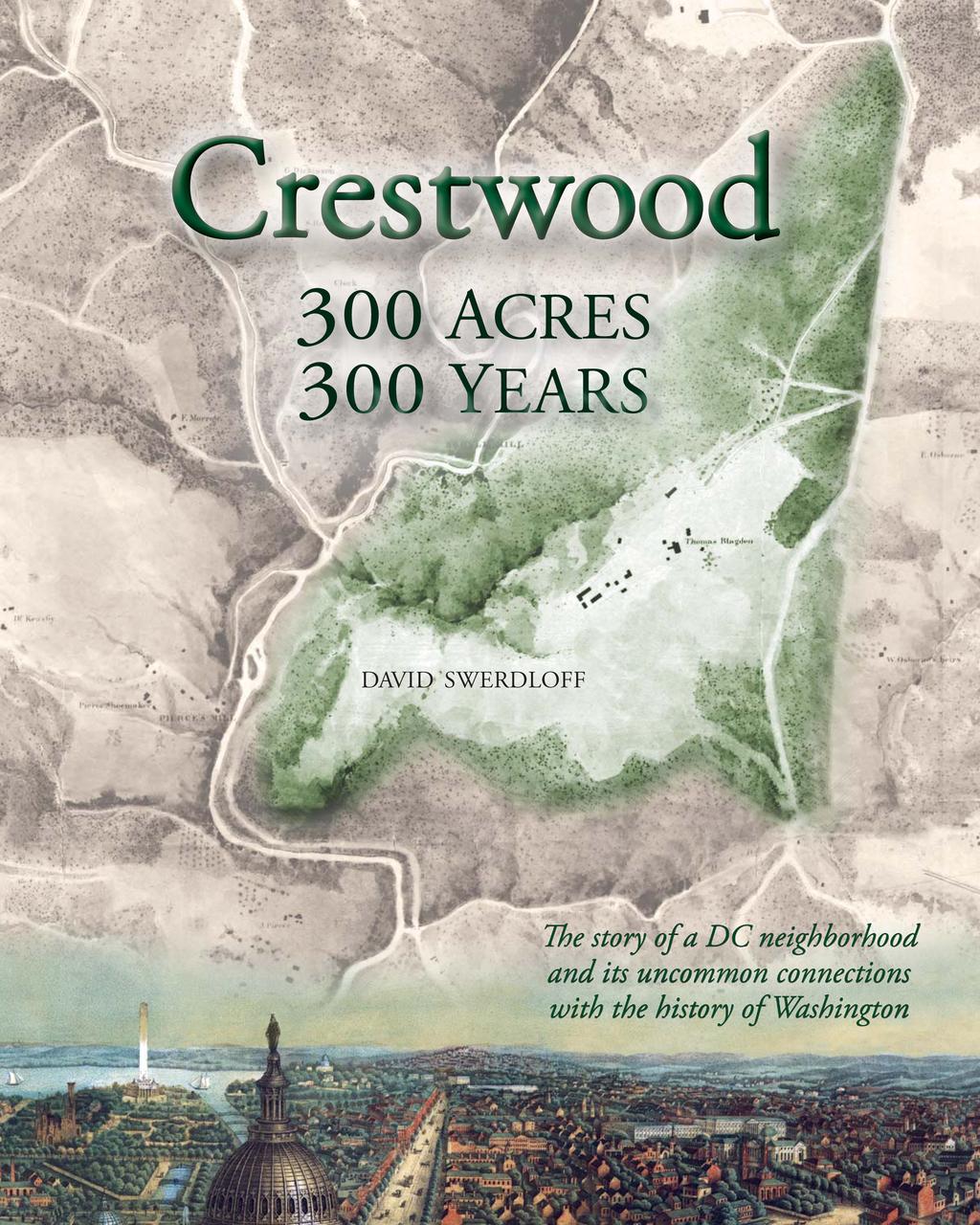
A modern street grid superimposed on the cover s 1867 map shows where the old roads and structures would be located in relation to today s Crestwood.
|
|
|
- Norman Shelton
- 5 years ago
- Views:
Transcription
1


2 Blagden Avenue 16th Street A modern street grid superimposed on the cover s 1867 map shows where the old roads and structures would be located in relation to today s Crestwood. Topographical sketch of the environs of Washington, D.C. by Nathaniel Michler, Source: Library of Congress Geography and Map Division Washington West Quadrangle topographic map, Source: U.S. Geological Survey
3 Cover credits: Front cover: Argyle estate highlighted on Topographical sketch of the environs of Washington, D.C. by Nathaniel Michler, Source: Library of Congress Geography and Map Division Below: Detail from View of Washington City, E. Sachse & Co., Baltimore, c Source: Library of Congress Prints and Photographs Division Back cover (modern map): Washington, DC & Vicinity Source: (2013) prepared by Geography Division, U.S. Census Bureau Inset: Crestwood sign at Blagden Avenue and Mathewson Drive Photograph by David Swerdloff Design: Lorraine Swerdloff
4 Crestwood 300 ACRES 300 YEARS DAVID SWERDLOFF
5 For Lorraine. Without you, all my pages would be empty. Copyright 2013 by David Swerdloff. All rights reserved. No part of this book, including text and images, may be used or reproduced without permission in writing of the author, except as allowed under grant requirements for use by the U.S. government and the Humanities Council of Washington, D.C. ISBN Researched and written by David Swerdloff Designed by Lorraine Swerdloff Proceeds benefit the Crestwood Citizens Association Crestwood: 300 Acres, 300 Years is supported by a DC Community Heritage Project grant. Funds for the DC Community Heritage Project are provided by a partnership of the Humanities Council of Washington, DC and the DC Historic Preservation Office, which provides information, training and financial resources to support people who want to tell stories of their neighborhoods and communities. This DC Community Heritage Project has also been funded in part by grant funds from the National Park Service Historic Preservation Fund (US Department of the Interior), administered by the DC Historic Preservation Office, and by the DC Commission on the Arts and Humanities. The Humanities Council of Washington, DC is an affiliate of the National Endowment for the Humanities. Statements, conclusions and views presented in this book do not necessarily represent the views of the Humanities Council of Washington, DC, the National Endowment for the Humanities or the Crestwood Citizens Association.
6 Contents Introduction 1 Origins Geology Indians Early Colonial History The Area Gets a Name The Lees, a Rich Grandmother and the Supreme Court 2 The 19th Century: Washington County Comes Alive The Peirce Family New Owners of Argyle 3 Bodacious Bodisco Beauty and the Beast That Bodisco Style 4 The Blagdens St. Elizabeths Life on the Argyle Estate A New Generation Blagden Deer Park The Blagden Subdivision Organizing for the Future 5 Engaged in a Great Civil War Camps, Batteries and Patrols Lincoln Rides Through ix v
7 6 The Area s Early African Americans 7 Old Roads Brightwood The Peirces and Their Slaves Thomas Blagden and African Americans The Archeological Record Piney Branch Road Fourteenth Street Road Blagden Mill Road The Oldest Roads The Seventh Street Turnpike Beach Drive 8 Rapids, Races and Recreation Crystal Spring Off to the Races Airy Castle Park 9 A Pleasure Ground for the American People Sewage Helps Inspire a Sanctuary Mapping out the Park Back to the Supreme Court Let s Meet at the Mill An Incursion into the Park 10 Roads and Bridges to a Suburb de Luxe Pebble and Boulder Bridges Who Was Upshur? Crittenden? Avenue of the Presidents A Streetcar Named Decatur Splendid Suburban Houses Mount Pleasant Heights Argyle Park Crestwood s Oldest Homes vi
8 11 Roaring 20s and Growing 30s Post-War Boom Blagden Park A Tale of Two Mansions The 1930s Public Works Projects Nearby Groundbreaking and a Goodbye Homes of Tomorrow 12 Association and Integration The Crestwood Apartments More Early History of the Association Non-Segregation Another Post-War Boom Civil Rights Struggle in Rock Creek Park An Integrated Alternative The Crestwood Expressway? Bridges Too Far 13 The Not-So-Distant Past Sesquicentennial Amphitheatre Ballet, Broadway and R&B Bombing in Crestwood A Member of Ike s Cabinet Neighborhood of Note Crestwood Memories Appendix A Census Charts Crestwood Population by Race, Crestwood by Number of Housing Units, Crestwood Population by Age, Crestwood by Size of Household, Appendix B Notable Residents 116 Appendix C Researching Your Home vii 120


9 The fi rst map of the 300-acre estate that would become Crestwood Argile Cowall and Lorn drawn as part of a survey in The map has been rotated from the original document so that north is at the top. N Source: Collection of the Maryland State Archives viii
10 Introduction The first map of what would become Crestwood was drawn in Remarkably, those 300 acres still largely define the community nearly 300 years later. From the very beginning, people traveled to or through this piece of land because of its natural features. The first visitors were Native Americans attracted by streams with prolific runs of fish, forests full of walnuts and game, and hillsides with mineral deposits they used for tools and spearheads. Starting in colonial times, newcomers took advantage of a creek that could turn mill wheels, a setting well suited for recreation, and land that could be cleared for crops and cattle. Today s residents are thankful that this natural world endures to provide tranquility in the middle of a bustling city. But the shady retreat we now call Crestwood has also been a good vantage point for observing history. U.S. presidents passed by. Civil War skirmishes took place within earshot. Protesters tramped through during the first significant march on Washington. Suburbs were developed outside the city center. Property owners brought four cases to the U.S. Supreme Court. Tensions in Europe led to a bombing in the neighborhood. Landmark events from emancipation to integration were reflected in the community. Crestwood also has links to the construction of the U.S. Capitol, the founding of St. Elizabeths hospital, the establishment of an urban national park, the escape attempt by D.C. slaves aboard The Pearl, and decisions made by the diplomats, activists, business leaders, cabinet officials and members of Congress who lived here. To help preserve the neighborhood s heritage, here is the story of Crestwood. We will encounter unusual places and personalities as we explore these 300 acres and 300 years and find uncommon connections with the history of Washington. ix
11

12 CHAPTER 1 Origins GEOLOGY Before any humans passed through Crestwood, its geology literally laid the groundwork for the way people would make use of the land. The neighborhood is located at the intersection of the hilly zone of ancient rock formations known as the Piedmont and the younger and smoother Coastal Plain. The boundary between these two regions is called the fall line which in the Crestwood area happens to run roughly along 16th Street. As a result, the community is indeed located at the crest of wooded hillsides, which are cut by streams such as Rock Creek and Piney Branch and which were dotted at one time by numerous springs. These features created a landscape that would make the area attractive as a place for recreation and home sites. Yet in contrast with communities east of the fall line where there were fewer hills, gorges and water channels to contend with the topography also delayed the building of homes and roads. The most significant barrier was the deep valley cut by Piney Branch creek, which isolated Crestwood as development spread north from the city below. So geology helps to explain why the beauty of Crestwood is timeless, but the oldest homes only date back to INDIANS Native Americans inhabited the greater Washington area for some 13,000 years before explorers and settlers arrived from Europe. Although they did not live in the Rock Creek valley, they probably took advantage of its bounty of fish, game and walnuts. About 4,000 years ago, they began to leave evidence of their visits to the area we call Crestwood: shards of rock discarded by Indians who quarried for quartzite in the hills above Piney Branch. The site below present-day Quincy Street and Crestwood Drive was studied in the 1880s and 90s Illustration of a 17th century Sasquesahanoug chief from Map of Virginia discovered and discribed [sic] by Captain John Smith 1606, William Hole, engraver; London, Source: Library of Congress Rare Book and Special Collections Division 1


13 Above: Ancient Indian quarry sites just down the slope from Crestwood toward Piney Branch creek. The top left-hand corner of the map corresponds to what is today called The Point at 18th and Shepherd Streets NW. Right: Quartzite stone fragments left behind at these quarry sites. Source of both images: J.W. Powell, Fifteenth Annual Report of the Bureau of Ethnology to the Secretary of the Smithsonian Institution, , 1897, Government Printing Offi ce, Washington, D.C. by the Bureau of American Ethnology, whose researchers reported that flakes of stone worked by the Indians poke from the soil in profusion and quartzite cobbled by the hundred dot the landscape. The leader of the research team, William Henry Holmes, suggested that the Indians would get to the quartzite by undermining sections of the hill using deer antlers, bone tools or wooden levers. They would break up the large stones into almond-shaped forms several inches long, leaving behind the nonusable pieces. The Indians would take the forms back to their campsites or villages and shape them with a rock or antler into tools and spear points. Some of the discarded debris remains buried in the ground near the southern edge of Crestwood. Uprooted trees occasionally bring these shards to the surface. It is illegal to remove archeological materials from Rock Creek Park but it s good to know that these early visitors did leave a calling card. EARLY COLONIAL HISTORY The establishment of Jamestown in Virginia in 1607 brought strangers into the Indians domain. A year later, Captain John Smith was the first outsider to explore the Potomac River, and he observed a possible passage beyond the mouth of Rock Creek. Maps that Smith published based on his 1608 exploration provided a remarkably accurate view of Virginia and beyond, including the Potomac. Henry Fleet began exploring the region nearly as soon as he arrived in Jamestown in Two years later, on a trade mission to a village of Patawomeke (Potomac) Indians near the present site of Washington, D.C., he found himself in the midst of a raid by a group of Nacotchtanks (Anacostans). Captain Fleet was taken prisoner for five years. 2

14 This portion of Captain John Smith s map of Virginia shows the Potomac River. In 1608, he would explore the river and may have observed Rock Creek. Detail from Map of Virginia discovered and discribed [sic] by Captain John Smith 1606, William Hole, engraver; London Source: Library of Congress Rare Book and Special Collections Division Before the Virginia government finally agreed to pay a ransom, he had learned to speak the Nacotchtank language and understood their customs. Fleet then returned to England, where he enticed investors into financing a 1631 expedition with the intention of establishing a fur trading monopoly in the Potomac Valley (Rock Creek Park Historic Resource Study, William Bushong, 1990, National Park Service). He was not averse to hyperbole, using these words in 1631 to describe what was to become the city of Washington: This place without all question is the most pleasant and healthful place in all this country, and most convenient for habitation, the air temperate in summer and not violent in winter. It aboundeth with all manner of fish. The Indians in one night commonly will catch thirty sturgeons in a place where the river is not above twelve fathom broad. And as for deer, buffaloes, bears, turkeys, the woods do swarm with them and the soil is exceedingly fertile. ( Worthy of the Nation, Gutheim, Bush & Lee, 1977, U.S. National Capital Planning Commission) When Maryland colonists arrived in 1634, Fleet acted as guide for Governor Leonard Calvert and helped ensure a peaceful start between the newcomers and the Natives. By the last quarter of the 17th century, settlers were arriving in the area that we now know as Washington. Most of them were Scots-Irish and, in the days before 1700, today s District of Columbia was known by the name New Scotland Hundred. The colonists often raised crops the Indians had taught them to grow, like tobacco and corn. Within a generation, these settlers would almost completely displace the area s Indian population. Colonel Henry Darnall was Governor Charles Calvert s chief agent in the colony, and his cousin 3


15 was Calvert s wife. Many of Maryland s leading families were interrelated. Darnall had received warrants in 1688 for about 6,000 acres of land stretching from the mouth of Rock Creek to present-day Silver Spring, including most of the land that became Rock Creek Park and Crestwood. In 1703, Colonel Ninian Beall purchased a 705-acre parcel carved out of this estate, which he called Rock of Dumbarton. The property would grow into the community of Georgetown. Beall s homestead appears on a 1712 map at the mouth of Rock Creek, making him the first recorded homeowner along the creek. In early 1719, Darnall passed on to John Bradford 500 acres of his holdings, including the property that would become Crestwood. Colonel Bradford was related through marriage to both the Darnalls and the Carrolls, served in the colonial General Assembly and had significant land holdings in both Maryland and England. Later in 1719 Bradford pledged 100 acres he owned east of modernday Crestwood for the erection of the first Rock Creek Parish chapel; on that parcel today is St. Paul s Episcopal Church and Rock Creek Cemetery (at Rock Creek Church Road and Webster Street) map by Swiss explorer Baron Christoph von Graffenreid shows Rock Creek and Ninean Beall s home site along the creek, as well as an Indian trail that roughly follows the path of today s Wisconsin Avenue. Map courtesy of and labeled by the National Park Service Inset: portrait of Beall from the 1899 book Early Days of Washington by Sally Somervell Mackall Document signed by John Bradford on March 10, 1719 carving out a 300-acre plot to be conveyed to Randall Blake. The boundaries of that property still largely defi ne the area we call Crestwood. Source: Collection of the Maryland State Archives 4

16 The original 1720 survey for Argyle Cowall and Lorn, the 300-acre estate that would become Crestwood. In the text, surveyor James Stoddert traced the boundaries of the property beginning and ending at a particular white oak tree. Distances in the text and in the summary at the bottom right were measured in perches. The right side of the map faces within a few degrees of north. Source: Collection of the Maryland State Archives THE AREA GETS A NAME The estate that became Crestwood came into existence on March 10, 1719, in what was then Prince George s County, when John Bradford did hereby sell, convey and make over unto Randall Blake my right to three hundred acres land part of a warrant for five hundred acres of land granted me out of his Lordship s Land Office the tenth day of February Bradford had owned Crestwood for 28 days. On August 4, 1720, James Stoddert completed the first survey of the property. Stoddert a Maryland merchant, landowner and surveyor famous today for having prepared the oldest surviving map of Annapolis also disclosed the name chosen for the estate: I have surveyed for the said Randall Blake all that tract of land called Argile Cowall and Lorn: lying in Prince Georges County: beginning at a bounded [or boundary] white oak standing on the west side of a branch called the piney branch of Rock Creek a little above the mouth of a small Branch within hollow of Peter Hyatt s plantation. 5

17 Blake s patent for Argile Cowall and Lorn was finalized on December 8, 1722 and the official record included the survey and the signed statements from Bradford and Stoddert. The name of the property has had a variety of spellings through the years. It refers to three places in what had been a county on the west coast of Scotland. Blake may have been in Maryland for some time. In August 1711, the will of William Jennings left Randall Blake one pair of French fall shoes. It is unclear how he earned the right to a land patent. In those days, settlers arriving in Maryland were promised 100 acres for every adult in their party, 50 acres for each child, and even more land for transporting additional immigrants to the colony. If they came up with the yearly rent, payable in produce, the land was theirs forever to pass on to their heirs. If the owner died without heirs, the property went back to the colonial governor. The area that became Washington, D.C. included land patents with more unusual names. Bordering Crestwood to the east is a parcel called Indolence. Other properties were named Conjuror s Disappointment, Poor Tom s Last Shift, Lucky Discovery and Frogland. Many patent names live on today, including Mount Pleasant, Chevy Chase, Friendship, Chillum and Whitehaven. Portion of a 2004 National Park Service map, Historic Parcels in and around Rock Creek, exhibiting the names of the original land patents. Argyll, Cowal and Lorn would become Crestwood. There is no evidence Blake or Bradford ever lived on the land that would become Crestwood, although the patent certificate shows that Peter Hyatt probably lived on an adjoining property. The 1722 Treaty of Albany with the Iroquois Five Nations brought more stability to the frontier, encouraging a wave of new settlers who were able to build larger farms. Wheat became a major crop, giving more business to the ports of Georgetown and Alexandria, and helping to spark the golden era of mills along Rock Creek. By this time, tobacco farms had exhausted much of the soil and many new farmers moved to the area from wheat country in Pennsylvania. When Bradford died on March 26, 1726 he had taken back control of the Argyle tract. His will instructed his executors to sell a long list of properties if necessary to pay his debts, including Argile Cowell and Lorn. The will referred to that property as having been bou. of Randolph Blake in tenure of Peter Hyatt. So Bradford purchased the land back from Blake though at the time he recorded Blake s first name as Randolph instead of Randall and he identified Peter Hyatt as being his tenant. That would seem to make Hyatt (the same individual named on the 1720 survey as having a neighboring plantation) the first person identified as living in Crestwood. The executors did not end up selling the Argyle tract. Instead, it became the property of Bradford s son, also named John Bradford. When the son sold the parcel in 1737, it may have been out of financial desperation. The Maryland General Assembly approved special legislation that year titled An Act for the Relief of John Bradford, a Languishing Prisoner in Prince Georges County Gaol. The law called for Bradford to assign transfer and make over unto the Sheriff of Prince Georges County his whole Estate both reall and Personall in order to pay his creditors. Peter Hyatt also seems to have run into financial trouble. A similar act in 1739 was introduced to benefit a man by that name who also was described as languishing in jail in Prince Georges County. 6


18 THE LEES, A RICH GRANDMOTHER AND THE SUPREME COURT The county sheriff was Richard Squire Lee, who owned the historic Blenheim estate along the Potomac River in Maryland near where the Harry Nice Bridge stands today. After Bradford s financial situation was resolved, Lee ended up owning the Argyle estate. At Lee s death in 1787, his holdings included 3,300 acres in Prince Georges and Charles counties, 900 acres in Montgomery County and at least 2,200 acres in Virginia. Because his son Philip Thomas Lee had died before him, ownership of the Argyle property went to Philip s son, Russell Lee. The Maryland Lees and the Virginia Lees were distant relatives; Russell and Robert E. Lee had the same great-greatgrandfather. This is where we begin two patterns that have repeated through the history of the Crestwood neighborhood: owners of Argyle dying without a will and litigation that reaches the U.S. Supreme Court. In 1793, Russell Lee died without a will at age 17 after being kicked by a horse on the Blenheim estate. To understand how the inheritance became a Supreme Court case, we have to look more closely at his family s circumstances. Russell was one of five children of Philip Thomas Lee, an English loyalist in the time before the Revolutionary War. Philip went to Eton, was admitted to the London bar, got married in England to his cousin, Ann Russell, and served in Maryland on the Governor s Council. Back in England, the Russells were a very rich family, and their wealth helped this branch of the Lee clan amass several properties in Maryland and Virginia. Russell Lee had four sisters Sarah, Anne, Eleanor and Margaret. Sarah Russell Lee married Benjamin Contee, who was her cousin and a member of another prominent Maryland family. Above: For the fi rst (but far from the last) time, the Supreme Court made a ruling in 1808 that involved the area known today as Crestwood. Source: William Cranch et al, Reports of Cases Argued and Adjudged in the Supreme Court of the United States, Banks Law Publishing, 1904 Below: Benjamin Contee, husband of Sarah Russell Lee; they were the lead plaintiffs in the case that involved the four Lee sisters. Source: Wikipedia Commons The Lee parents had been accustomed to traveling back and forth across the Atlantic, but prospects for a revolution by the English colonies intervened. As the story is told in the Maryland Historical Magazine (volume 72-73), Eleanor was a young child who with her younger sister Margaret Russell Lee was left in the care of their grandparents Russell when their parents... returned to America in The war cut them off from their parents. In 1783, both girls were still living in England, where they received loyalist pensions. While Ann eventually moved to America, Eleanor remained in England in her grandmother s care and married William Dawson. At the time of Russell Lee s death, Maryland law prohibited non-americans from inheriting property in the state. The question was: could Eleanor, who had never even visited America, collect her share of the Argyle property? 7
19 The three other sisters attempted to keep Eleanor from any part of the inheritance. Sarah and Benjamin Contee were the lead plaintiffs in the U.S. District Court case Contee et al v. Godfrey. The court ruled that Eleanor was not legally entitled to inherit land. In 1808 the U.S. Supreme Court agreed, in Dawson s Lessee v. Godfrey rejecting the argument that she should have the protection of Maryland law because her family was a Maryland family. While the litigation wound through the courts, the grandmother (named Ann Lee Russell) died in Her will had a codicil that warned the other three sisters not to deprive Eleanor of her inheritance, no matter what the courts ruled: Understanding, that my granddaughters in America, viz. Mrs. Sarah Contee, Miss Ann Lee, and Mrs. Margaret Russell Clerk, intend to contest their sister Eleanor Lee s right to her share of her grandfather s, grandmother s, father s and mother s lands and personal estate in Maryland and Virginia, I hope and trust they are not so unnatural; if it prove so, I will and desire, that every shilling I have left them in my said will, be paid my dear Eleanor Lee, added to the legacy I have left her in my will, as a compensation for what she loses by their cruelty; but if they do not contest it, and my dear Eleanor Lee receives an equal share of all the lands and personals belonging to their grandfather, grandmother, fathers and brothers, the legacy I have left in my will to remain good. Ultimately, Eleanor Lee Dawson did move to America, and she ended up as sole owner of the Argyle property that would become Crestwood. In September 1833 Dawson contracted to sell Argyle for $3,500 to a man named Robert Reynoldson. But then she died witho ut a will, leaving her son Frederick to work with his five brothers and sisters to try to consummate the deal. Four of them had moved back to England, where they were described in papers filed with Argyle deeds as Robert Dawson late of Baltimore in Maryland in the United States of America but now of Liverpool in the County of Lancaster in England, Merchant and Mary Ann, Eleanor Georgiana and Frances Laura Dawson all late of Baltimore in Maryland in the United States of America but now residing in Lilley Hill near Winkfield in the county of Berks, spinsters. After three years without a settlement, Reynoldson had enough. He agreed on Christmas Eve 1836 to sign over his rights to Argyle to Georgetown lawyer William Redin for $3,500, and let Redin deal with the red tape. After receiving deeds from both the American and English sides of the Dawson family, Redin finally took ownership of the property in But Frederick Dawson did take him to court to get him to pay another $1,889 apparently appreciation and interest since the time of the original purchase. Redin was a prominent Georgetown attorney who had been admitted to practice before the U.S. Supreme Court. Born in Lincolnshire, England, he was a lawyer in the old country before coming to the United States around He bought and sold quite a few properties in Washington in the 1830s, 40s and 50s, most famously the Woodley estate in Cleveland Park. Over the years, this 1801 mansion was the summer White House for two U.S. Presidents and home to George Patton and several cabinet secretaries. Redin sold it in Today the home is part of the Maret School. One of Redin s 1837 deeds for the Argyle property described its location this way: 300 acres of land, more or less, touching Rock Creek on the west and bounded by the lands of Messrs. Pierce and Mrs. Osborn and George Broaduss (late Frenches) and of the heirs of Dr. Worthington and of Holmead. It is doubtful that, up to this point, any of the owners of the estate ever lived there. If tenant farmers called Argyle home, other than Peter Hyatt their names are unknown. Also unknown are the names of early millers who ran the estate s mills that might have been built along Rock Creek prior to Right: Detail from Andrew Ellicott s 1794 map of the Territory of Washington shows the bluffs where Crestwood would eventually be developed. The one nearby thoroughfare, Rock Creek Road, traces a path that today would include parts of Columbia Road, Rock Creek Church Road and Blair Road. Source: National Park Service 8

20 Future site of Crestwood 9
21 CHAPTER 2 The 19th Century: Washington County Comes Alive On the eve of the 19th century, most of the land that became the District of Columbia remained forest. Beyond the cities of Georgetown and Alexandria, the population consisted of a handful of rich landowners and larger numbers of poor farmers. The map on page 9, based on a 1794 survey, shows few roads into the wilderness. However, Rock Creek was a dynamic waterway, with a wide mouth that allowed ships to sail as far north as P Street and with numerous spring-fed streams flowing into the creek up and down its length. There was a small village near the Argyle estate beginning as early as Crystal Spring was a farm settlement at a crossroads northeast of presentday Crestwood along Milkhouse Ford Road (not far from where Military Road is today). The settlement grew to become Brightwood. But its original name came from a spring that flowed into Rock Creek much closer to the Argyle property; on a modern map it would be west of the intersection of 16th and Kennedy Streets. In 1800, Washington became the nation s capital, and the race was on to develop what was called Washington City. Argyle was in Washington County beyond the city limits, but still within the District of Columbia. County farmers felt confident in their future, as they anticipated a growing market in the city and new roads that would give them access to that market. While it would be a busy century in the area known today as Crestwood, only a few families lived on the property during the 1800s. The neighborhood s story remained one of people traveling through to get to the mills, to recreation sites, to the forts that protected the Federal City during the Civil War, even to the racetrack. Yet, by the end of the century, the mills were abandoned, the racetrack was almost gone, the Civil War had sparked a huge spike in development, the recreation sites had inspired the establishment of a national park and the Crestwood neighborhood was finally poised for development. THE PEIRCE FAMILY The first estate in the area of Crestwood to become highly developed belonged to the Peirce family. Isaac Peirce moved to Maryland from Pennsylvania in the 1780s and found work in Georgetown as a millwright (someone who builds and repairs mills). He ended up marrying the boss s daughter and, in 1794, he was doing well enough to purchase a 150-acre property on the west bank of Rock Creek. The land already included a mill, and the National 10


22 L Enfant s 1791 map shows Rock Creek labeled as Pine Creek. At the top, he has noted next to Piney Branch that its water may supply the City if it was connected to a branch of Tiber Creek. The Argyle estate that became Crestwood would be located just above Piney Branch. Peter Charles L Enfant, Plan of the city intended for the Permanent Seat of the Government of the United States. Source: Library of Congress Below: A weathered stone marker on Peirce Mill includes the inscription BIP 1829, suggesting that the mill was completed that year. The letters may stand for built by Isaac Peirce or Betsy and Isaac Peirce. Photograph by David Swerdloff Park Service cites records from 1798 to show that Peirce s flour mill was a custom mill to which local farmers and residents brought their harvested grains for processing into flour for home use. Then, in 1795, a man named Oliver Evans transformed the industry with a book titled The Young Mill-Wright and Miller s Guide, turning milling into more of a science. Using lessons from the new guide, Isaac and his eldest son Abner, a stonemason, rebuilt the mill in the 1820s, creating a facility with a much broader commercial use. The new building was constructed of blue granite quarried nearby on Peirce property along the banks of the Broad Branch or Piney Branch tributaries of Rock Creek. Isaac also kept adding to his estate. At his death in 1841, he owned more than 1,200 acres in Washington County. He had built numerous buildings on the property adjoining today s Crestwood, including a springhouse, carriage house, cow barn, distillery, potato house and miller s house. And he constructed Peirce Mill Road to connect to the new roads coming into Washington County so that farmers could reach the mill and flour and other goods could be transported to the port in Georgetown. Isaac bequeathed the farm to Abner Peirce and, after Abner s death in 1851, it became the property of Abner s nephew, Pierce Shoemaker (the son of Isaac Peirce s daughter Abi- 11


23 Joshua Peirce Source: National Park Service, undated newspaper clipping gail and David Shoemaker). Isaac Peirce also carved out 82 acres of his estate and passed that land on to his youngest son, Joshua. That s where a fine stone manor house was constructed. Today we call it Klingle Mansion, because it was bequeathed by Joshua Peirce to his nephew, Joshua Peirce Klingle, who was living with his uncle to learn the nursery business. Joshua Peirce entertained Washington s political leaders, including Henry Clay, Daniel Webster and John Calhoun. But he became famous as a horticulturalist, thanks in part to good marketing. While his property had originally been called Lee Rig, Joshua changed the name to Linnaean Hill after the Swedish botanist Carl Linnaeus, who founded the modern system of classifying living things into kingdoms, classes, families, orders, genera and species. The new name for the property helped to advertise Joshua s expertise as a nurseryman. The U.S. government became one of his biggest clients. His trees, flowers and shrubs beautified the grounds of the U.S. Capitol, the Executive Mansion and other federal properties. He published a catalog and sent agents to other cities. Many Washingtonians took carriage rides out to Linnaean Hill to The painting below dates from between 1830 and 1840, providing the earliest view of Peirce Mill, including the ford across Rock Creek near where the Tilden Street/ Park Road bridge is located today. Source: Peirce Mill, Rock Creek Park, Cultural Landscapes Inventory, National Park Service. Inset: 1897 photograph of the front of Peirce Mill. Source: National Park Service 12

. Peirce Mill was itself a gathering place for visitors coming up from Washington City: In Washington s early days the old place was a great picnic resort.")
24 view rare camellias and other exotic plants or to buy specimens. As Pierce Shoemaker s son, Louis Shoemaker, wrote in April 1908, Linnaean Hill was not only the scene of a large and profitable business, but the grounds were artistically treated, the plants, rare flowers and trees were so beautifully arranged that the place was converted into a horticultural and rural park, where the people of the national capital sought pleasure, recreation and instruction (Historic Rock Creek, Louis Shoemaker). Peirce Mill was itself a gathering place for visitors coming up from Washington City: In Washington s early days the old place was a great picnic resort. Especially attractive it was to the old volunteer fire companies and the military organizations, even if it was a long distance to haul the engine or march on a warm summer day with oldfashioned muskets on the shoulder. Sunday schools also had their picnic parties there, when the old folks and children were carried in long omnibuses and were happy all the day long. (Washington Times, December 13, 1903) Above: Washington Times, December 13, 1903 Right: Evening Star advertisement for Joshua Peirce s nursery business, October 22, 1856 Peirce had another nursery in the city on 54 acres in northwest Washington between 14th and 16th Streets and R and S Streets. The businesses made Joshua a wealthy man, with an estate valued at $150,000 at the time of his death in In the mid-1870s Isaac Peirce s grandson Pierce Shoemaker built the house called Cloverdale, which stands today on the south side of Tilden Street just below Linnean Avenue. Another branch of the Peirce family also became well known for horticulture, turning a Pennsylvania farm into a public park with one of the finest collections of trees in the United States. Pierre du Pont 13

25 bought the property in 1905 to preserve the trees, and he further developed it into the lush showplace that is Longwood Gardens. NEW OWNERS OF ARGYLE The mills further up Rock Creek on the Argyle property may have been in operation before the Peirces moved into the area, perhaps as early as One piece of evidence cited is the inability of Isaac Peirce to purchase the parcel during the 1790s when he was acquiring so much land by the creek (Milling in Rock Creek, Charles H. Mc- Cormack, 1967, National Park Service). At the time, development on the Argyle property may have been limited to the mills and the miller s cabin. Early in the 19th century, a new and better mill was constructed on the site, which would be located today along Beach Drive 0.3 miles north of Blagden Avenue. Evidence indicates that Isaac and Abner Peirce built the new mill. The same stone was used as in Peirce Mill, and the design and dimensions of the two buildings were nearly identical, except for window placement. The date stone (most likely lost when the mill was torn down in the 1890s) is said to have included Peirce s initials and the actual date of construction. In fact, Peirce Mill may have been an effort by the family to improve upon their earlier work at the Argyle site. Seven years after the Argyle property came into the hands of William Redin, he sold the estate on June 7, 1844 to Thomas Lilly for $6,000. It didn t take long for Lilly to make money on the deal; he sold the 300-acre property on October 6, 1845 to Alexander de Bodisco for $7,500. Both the new deed, as well as the deed of sale from Redin to Lilly, mentioned a survey of the Argyle tract done by surveyor Francis Fenwick in This survey began, not at a particular white oak tree (as in the original 1720 survey), but at a large stone standing on the West side of a Branch called the Piney Branch. That stone had been marked with this inscription: Here stood the beginning of Arguile Cowal and Loarn. The stone remains unaccounted for. Perhaps it was destroyed during construction of the 16th Street bridge or Piney Branch Parkway. Or perhaps it is still buried somewhere along the Piney Branch, waiting to be rediscovered. Engraving from the Evening Star, February 27, 1892, may show The 1816 survey is one of the mills on the Argyle estate. identical to the one from Each segment of the border of the Argyle tract is the same length. The only improvement was the addition of exact degrees of the compass for the direction of each segment. Everyone with an interest in Argyle sat down together on December 17, 1816 to confirm that the boundaries of the property would follow Fenwick s survey with the variation of three degrees & an half. The agreement was signed by Eleanor Dawson s son William, along with neighboring landowners Isaac Peirce, John Holmead, George Peter, Charles Worthington, Archibald Osborn and Robert French. 14

26 CHAPTER 3 Bodacious Bodisco The new owner of the Argyle property in 1845, Russian Count Alexander de Bodisco, had been the Czar s Ambassador in Washington since Bodisco used the Argyle tract as the site of his country or summer house. The mansion was most likely the wood frame structure that was torn down in 1934 near the corner of 18th and Varnum Streets although that house may have been rebuilt after a fire in The Baltimore Sun reported (January 6, 1849): We learn from the Washington Union that the residence of Mr. Bodisco, the Russian minister, about three miles from that city, was destroyed by fire on Thursday morning at 3 o clock. It is supposed to have been the work of an incendiary. The minister s family had previously removed to Georgetown. Nevertheless, the Washington Post recollected (August 18, 1889), with no mention of a calamitous fire, Russian Ambassador Alexander de Bodisco, shown here at the time of his 1840 wedding to a Georgetown teenager, was the fi rst person to develop the estate that became Crestwood. He built a manor house, conservatory, bowling alley, stables and outbuildings. Source: General Photograph Collection, Historical Society of Washington, D.C. 15 that Bodisco had built a fine mansion, a conservatory, bowling alley, and numerous barns and outbuildings upon the plateau. And 10 years later (January 29, 1899), the Post looked back again, reporting that Bodisco improved his country place on a style in keeping with his wealth and position. The large, oldfashioned mansion and extensive grounds mark his ideal of what a country home should be. Bodisco was one of the most popular diplomats in Washington and (said the March 1878 Harper s New Monthly Magazine) the most sagacious and popular ambassador ever sent from Russia to this country. His nickname in the capital was Uncle Sasha. He frequently entertained at the Russian legation and, after his marriage, at the federal period house at 3322 O Street in Georgetown, which he purchased as a wedding present for his young wife. The home eventually came into the Heinz family, so that today it is the D.C. residence of John Kerry and Teresa Heinz Kerry.
 The facts of the Bodisco marriage could be grossly distorted in the press, as in the report at left.")
 BEAUTY AND THE BEAST The Ambassador was so well-regarded in Washington society that he weathered a scandal precipitated by his obsession with a")

27 This image of the Bodisco wedding on April 9, 1840 comes from a book by Harriet Williams school chum and bridesmaid, Jessie Benton Fremont. (Souvenirs of My Time, D. Lothrop & Company, Boston, 1887) The facts of the Bodisco marriage could be grossly distorted in the press, as in the report at left. (Columbia Democrat, Bloomsburg, PA, March 21, 1840) In later years, the affair was romanticized as a cherished memory of Georgetown society. (above, Washington Times, December 20, 1903) BEAUTY AND THE BEAST The Ambassador was so well-regarded in Washington society that he weathered a scandal precipitated by his obsession with a 16-year-old Georgetown girl, Harriet Beall Williams. After a short but storied courtship, he married her in 1840 in a wedding attended by President Martin Van Buren, Daniel Webster and future President James Buchanan. Henry Clay gave away the bride. At the time of the wedding, Miss Williams was only seventeen but tall and splendidly developed as described in the 1869 book The Court Circles of the Republic, Or, The Beauties and Celebrities of the Nation by Elizabeth Fries Ellet and R. E. Mack. Going by the birth date on his grave in Georgetown, the Ambassador was 53 when he married, though news reports and memoirs kept placing his age higher and higher. The legend goes that Alexander met Harriet at a Christmas party he hosted for his two nephews, and he was at once determined to marry her. According to the Washington Times ( Christmas Romance of Old Georgetown, December 20, 1903), as he wooed Harriet, he escorted her to school every morning and carried the pretty scholar s school books and he was present when the hour for closing studies arrived to escort her to her home, and there was no more gallant and impassioned wooer in all the universe. They often met along Georgetown s Lovers Lane, then located on the Williams property. As the New York Herald reported, Baron Bodisco was ugly, in fact preeminently so, and some people went so far in their disapproval of the marriage as to refer to the old fairy tale, Beauty and the Beast. It was widely reported that, as a newlywed visiting her husband s country for the first time, Harriet managed to charm the family of Czar Nicholas despite, by some accounts, her social missteps, such as refusing an invitation from the Czarina because 16
28 the occasion was on a Sunday. Each faux pas was instead looked upon as a delightful quirk. A 1905 memoir goes so far as to say that Harriet was one of the first to draw the attention of foreigners to the beauty of American women : Before she was really of an age to appear in society... Harriet Williams became the Baroness de Bodisco, and was carried abroad for presentation at the Russian Court. Her appearance in that critical circle created a furor, echoes of which preceded her return to America. I have heard it said that this young bride was the first woman to whom was given the title, the American Rose. (A Belle of the Fifties: Memoirs of Mrs. Clay of Alabama, Covering Social and Political Life in Washington and the South, by Virginia Clay-Clopton and Ada Sterling) It was a life quite different from her classmates at the Lydia English Female Seminary in Georgetown. In the November 1898 edition of Gentleman Farmer magazine, Mrs. W. S. Powell described the wedding and Harriet s transition to a new life: There was great excitement in the school when the famous Bodisco wedding came off; eight of the girls were bridesmaids, Jessie Benton coming first with James Buchanan... Jewels that had adorned the persons of hundreds of generations of Bodiscos were brought over the sea to deck the girlish bride, who stepped from the quiet life of the Williams home into all the gaieties of the capital, becoming at once a queen of society, dividing honors with the beautiful Harriet Lane, then, as the President s niece presiding at the White House. Crowds would collect on the streets to watch Madame de Bodisco pass by on her way to the levees at the White House, whither she would go in pleasant weather in an open carriage, usually attended by mounted policemen to guard the diamonds worth half a million. Numerous memoirs said Count Bodisco was involved in every detail of the wedding, from the multitude of celebrations to the gowns of the bridal party. More than a century after their marriage, the Bodisco wedding made it into a popular work by Irving Stone. The author, who wrote such biographical novels as The Agony & the Ecstasy about Michelangelo and Lust for Life about Vincent van Gogh, included the Bodiscos in his 1948 novel Immortal Wife. The book dramatizes the life of writer and political activist Jessie Benton Fremont. Here is Stone s dialogue as Jessie informs the man she would eventually marry, John C. Fremont, that her friend Harriet Williams had become engaged to the Russian Ambassador: Count Bodisco? he asked, with a puzzled, almost pained expression. Isn t he the pretentious one who drives to his Embassy every day in a snow-white barouche drawn by four black horses? Yes, I suppose he is pretentious, but in a kindly sort of way that does no one any harm. He s just trying to maintain the dignity of the Russian aristocracy in what some of the other ambassadors call a mudhole capital. But, he exclaimed angrily, he s an old man. He must be past sixty! Just sixty. And Harriet is just sixteen. But he is so terribly kind, the Count Bodisco. He has been most generous to her parents. Just think, Lieutenant, last week Harriet wasn t good enough to be the May Queen at this school, and in a couple of weeks she will be Countess Alexander de la Bodisco, cousin to the Czar, with a state wedding. THAT BODISCO STYLE The wedding was just one place where Count Bodisco showed off his distinctive style. A letter by William Pitt Fessenden (who served in Washington as Senator from Maine and Treasury Secretary) refers to the Ambassador as strapped in lace and glittering with orders beruffled, bepadded, bestiffened, wigged, mustachioed and whiskered a short, thick squat fellow, but civil and well bred. Author John Robert Irelan concurred in his 1887 History of the Life, Administration, and Times of Martin Van Buren. He described a party Bodisco 17

29 hosted in the winter of 1839 (perhaps the very one where the Ambassador became enamored of Harriet): The Russian Minister, Bodisco, was a pompous old European courtier, and prided himself on his superior social qualities... Bodisco himself outdressed all his guests. He was arrayed much like a harlequin. He wore pumps which glittered with precious stones, and silver lace with brilliants ornamented his blue dress. His guests were fed with gold spoons and forks from plateaus of gold with mirrors. The affair turned the society heads and made the old bachelor very popular. Bodisco organized many grand balls at his Georgetown residence. The Baltimore Sun reported on one he gave in February 1847 in honor of the Czar s birthday: The magnificence of the baron s entertainments is proverbial, as some five or six hundred invitations were issued, extending through all the different degrees of high life, thronging the metropolis. For some time after his marriage, the Ambassador would host weekly dinner parties, which ended with dancing and games of whist. Emperor Nicholas had a special allowance made for table money, wrote Benjamin Poore in the 1886 Perley s Reminiscences of Sixty Years in the National Metropolis. However, one night he sat down to play with those better acquainted with the game and he lost over a thousand dollars. At the supper table he made the following announcement in a sad tone These receptions must have an end. The fund for their expend, ladies and gentlemens, is exhaust and they must discontinue. It was well-known in Washington that Bodisco owned valuable real estate in the United States, including the Argyle estate. In 1849, while the Ambassador was back in Russia, reports spread that he had been banished to Siberia because the Czar supposedly would not allow his representatives to own property in the countries to which they were accredited. The dispatches turned out to be a hoax. Some more serious intrigue may have been going on. A Russian language encyclopedia (translated in 2009 by Crestwood neighbor Maria Sokurashvili) reports that Bodisco tried unsuccessfully to persuade the Czar and U.S. authorities to take control of parts of California from the weakening hands of the Mexican government and then split the territory between the two countries. Until January 1, 1842, Russia did maintain an outpost at Fort Ross, a bit north of San Francisco. Harriet Williams, from a large portrait that graced the Georgetown home of her parents. The life-sized painting shows her in the clothing she wore when she was presented to the Czar as the new wife of Russia s ambassador to the United States, Alexander de Bodisco. She wore the same gown in 1849 at an inaugural ball for Zachary Taylor. It was described on that occasion (in Lydia Gordon s From Lady Washington to Mrs. Cleveland, 1889) as consisting of a dress of white satin embroidered with gold, and over it she wore a crimson velvet polonaise with a sweeping train also embroidered with gold, while her crimson velvet head dress was resplendent with diamonds. Source: General Photograph Collection, Historical Society of Washington, D.C. 18
 did repeat a story that Bodisco kept several Russian bears for his amusement at his country home but the reporter said he didn t have any actual evidence of bears at")
30 It is unclear whether Bodisco ever threw any parties, carried out any diplomacy or hosted any games of whist at the Argyle property. The Sunday Star (March 6, 1932) did repeat a story that Bodisco kept several Russian bears for his amusement at his country home but the reporter said he didn t have any actual evidence of bears at Argyle. The estate was the site of the birth of the couple s youngest child. Bodisco and Harriet had seven children, wrote Alexandre Tarsuidze in the 1958 book Czars and Presidents, the youngest, William Basil, born at their country house just outside Washington. Bodisco s devotion to his wife may have cost him his life. The Washington Post (November 4, 1894) recalled that the Ambassador had waited in the wintry cold for Harriet to return to Washington from Europe on a ship that had been greatly delayed. That exposure led to a fatal illness: A side of his face was almost black; he had received a terrible wind blow. He never recovered, and died soon after. The response from Congress was immediate. Washington, January 24 The Senate and House of Representatives adjourned over to-day as a mark of respect for, and to attend, the funeral of M. Bodisco to-morrow. (Baltimore Sun, January 25, 1854). In 1860, Harriet went on to marry a younger man, British Army officer Douglas Gordon Scott saying that it was the dying request of her husband for her to marry again. This time President Buchanan gave away the bride. Shortly before his death, Bodisco sold the Argyle proper- ty to Thomas Blagden. The deed recorded October 22, 1853 reveals that Blagden paid $25,000. That high a price confirms the many improvements Bodisco made to the property. In Crestwood in recent years, residents would tell stories of old stables in the neighborhood, calling them the Russian stables holding out the possibility that some buildings from Bodisco s time might have endured. In a 1988 real estate ad, the house at 1826 Varnum Street was touted as part of the Tsarist Embassy at one time and as having been erected by the Count and Countess Bodisco in the mid-1800s. An old wood frame barn and carriage house on that lot did disappear from D.C. real estate maps after 1915, just before a modern home was built there in Bodisco s final resting place at Oak Hill Cemetery in Georgetown has at least one thing in common with his old country manor: it overlooks Rock Creek. This monument at Oak Hill Cemetery in Georgetown marks the gravesite of Alexander de Bodisco and several of his descendants. Part of the pillar inscription reads: Sacred to the memory of Alexander de Bodisco, Chamberlain Private Counselor of His Majesty the Emperor of all the Russias, His Envoy Extraordinary and Minister Plenipotentiary to the United States Born at Moscow the 18/30 October 1786 Died at Georgetown the 11/23 January Photograph by David Swerdloff 19


31 CHAPTER 4 The Blagdens Thomas Blagden, who in 1853 purchased the Argyle estate that became Crestwood, was the son of George Blagden. George left Yorkshire, England for Washington in 1793 and became what the National Intelligencer newspaper called one of the first settlers in Washington, having been here from the laying of its foundation stone. George Blagden is most famous for his work as the chief stonecutter for the construction of the U.S. Capitol building. He also built two homes for George Washington that formerly stood on North Capitol Street in an area that is now part of the Capitol grounds. A letter from Washington survives today, which complains about the price George Blagden wanted to charge. According to the Sunday Star (March 6, 1932), Washington planned to live in one of the houses after his presidency, but died before they were completed; the homes instead became congressional boarding houses. Blagden also served on city boards and was a director of the Bank of Washington. His many enterprises helped him accumulate quite a fortune Portraits of Thomas Blagden and his fi rst wife, Emily Green Silliman. Source: Allen Blagden before he died in Blagden lost his life in a construction accident on the Capitol grounds, when a ditch collapsed while he was inspecting work on the building. He was one of the founders of Congressional Cemetery, where the Blagden vault (dated 1831) holds the remains of many members of the Blagden clan. Ironically, the final resting place of this celebrated stonecutter is a mausoleum of plain red brick. George Blagden named his elder son after his former client. George Washington Blagden became a famous Boston clergyman and, at one time, pastor of the city s Old South Church. Thomas Blagden s success was more secular. He first became prominent in Washington as a lumber merchant. In

 between 3rd and 4th Streets, just southeast of where the Navy Yard Metro station is today.")
32 George Blagden built two houses for George Washington, who complained that the estimated cost of construction far exceeds any aggregate sum I had anticipated in the letter at right, dated October 4, Source: Library of Congress Thomas Blagden honored the memory of George Washington by becoming one of the original members of the Washington National Monument Society, as named in the charter at left, approved by Congress in Source: Address of the Washington National Monument Society to the People of the United States, Gideon, Washington, D.C., he purchased a wharf on the Anacostia River (then known as the Eastern Branch of the Potomac) between 3rd and 4th Streets, just southeast of where the Navy Yard Metro station is today. Blagden s Wharf used to be called Smallwood Wharf after a previous owner, Samuel Smallwood, who was appointed mayor of Washington in 1819 and became the city s first elected mayor in As it happens, Smallwood s grave is next to the Blagden vault. Thomas Blagden also continued the family s connection with George Washington, becoming a major backer of the effort to create a granite tribute to our first president. In 1839, he was one of the original incorporators of the Washington Monument Society. And Blagden married into an old American family, the Sillimans. His wife was the former Emily Green Silliman, whose great-greatgreat-great-grandparents were the Pilgrims John and Priscilla Alden (according to the Register of the Society of Colonial Wars in the District of Columbia). Thomas Blagden became a major player in Washington s real estate market. His finest achievement may have been a row of five four-story houses he built in 1852 in the 300 block of Indiana Avenue NW. Blagden s Row was a convenient and elegant address for such famous men as Supreme Court Chief Justice Roger Taney and various U.S. Senators and diplomats. The homes were razed in 1931 to make way for the D.C. Municipal Building. He was also responsible for Blagden Alley, now an official historic district (together with Naylor Court) off M and N Streets NW, between 9th and 10th. These narrow roads are among the few remaining examples of alleyways where Washington s working poor lived alongside warehouses and stables. The residents included many African Americans who migrated to D.C. following the Civil War and lived in mainly small, overcrowded buildings. But free blacks also owned real estate in the neighborhood in advance of the emancipation of the District s slaves in Houses in the area near Blagden Alley included the home of Blanche Kelso Bruce, a man born in slavery who went on to become the first African American to serve a full term in the U.S. Senate. Thomas enjoyed the connections he inherited from his father along with an interest in the continuing construction of the Capitol. In 1854, the Italian artist Constantino Brumidi arrived in Washington to paint frescoes throughout the building, including the massive Apotheosis of Washington on the dome of the Rotunda. According to Blagden 21


33 The portrait, attributed to Constantino Brumidi by the Blagden family, is of Thomas Blagden s son, also named Thomas. In this era, parents often paid little regard to gender differences in young children. Many portraits show boys in dresses and sporting long hair until they reached breeching age and began to wear trousers. Source: Allen Blagden Brumidi possibly used young Thomas as the model for some of the cherubs with which he decorated the Capitol building. Shown is part of a frieze from the fi rst room he designed. Source: Library of Congress family lore, Thomas put up Brumidi, perhaps at the Blagden s city home on New Jersey Avenue SE or at Blagden s Row. The family claims that Brumidi painted a portrait of Thomas Blagden s son Thomas and used it as a model for various cherubs in his fresco work in the U.S. Capitol. ST. ELIZABETHS One of Thomas Blagden s most prized properties was a farm he purchased in The Daily National Intelligencer newspaper reported (April 1, 1847) he paid $4, for the estate. The parcel sat on a wooded bluff in Anacostia and took its name from the original Maryland land patent, St. Elizabeths. From those heights, he could see the still-unfinished Capitol building where his father had worked and died. Blagden developed the property and might have been content to keep the farmstead as his family home. But the site was also prized by reformers, led by Dorothea Dix, who had persuaded Congress to fund the first large-scale federal mental hospital. In the end, they also persuaded Blagden to sell the farm, which became the site of St. Elizabeths Hospital. The sale, at a figure well below Blagden s asking price, led to his purchase of the Argyle estate, where Crestwood is located today. The story began when the hospital s first superintendent, Dr. Charles Henry Nichols, was unable to induce Blagden to sell at the price set by Congress: In carefully examining the whole country surrounding Washington, [Nichols] had made up his mind that there was no other site at all compared with it. Mr. Blagden, however, turned a deaf ear to every proposition on the part of Dr. Nichols to buy it. The estate had become endeared to him through the exceptional beauty of its situation, and was, moreover, the especial pride of his wife and daughters. Besides, the full amount appropriated by Congress for the purchase of a site was but $25,000, and on no consideration, Mr. Blagden insisted, would he part with the property at less than $40,000. One day, after having exhausted every personal effort, and thoroughly depressed in spirits, Dr. Nichols went in to see Miss Dix. There is nothing more to be done! he exclaimed; we shall have to give the matter up; and it is the finest site for a hospital in the world! (Francis Tiffany, The Life of Dorothea Lynde Dix, 1890) Dix sought her own appointment with Blagden, where she made a successful appeal to get him to sell the farm for the $25,000 Congress provided. However, Blagden seems to have had a bad case of seller s remorse, as Tiffany writes: On Dr. Nichols s calling on him the next day, with the requisite papers to sign, Mr. Blagden was found walking the room to and fro, weeping and wringing his hands in a half-hysteric condition. I don t want to part with it! he kept reiterating. It is dear to 22

34 Even in this 1886 map of Washington, the Argyle estate that would become Crestwood is shown as empty countryside. Thomas Blagden purchased the estate in 1853 with the $25,000 he received from the sale of his farmstead on the St. Elizabeths property. B.H. Warner & Co. s Map showing a bird s-eye view of the city of Washington, Source: Library of Congress Geography and Map Division me and dear to my family! But I won t break my promise to Miss Dix, I won t break my word! I told her she should have it, and she shall have it! Such scenes as this do honor to human nature. Indeed, it would be hard to instance a more beautiful tribute to the power of consecrated womanhood than is found in the following letter, so simple, hushed, and awestruck in its tone, sent to Miss Dix by Mr. Blagden, the evening of the day on which she had thus closed in, in Jacob s angel wrestle, with his deepest nature. DEAR MADAM: Since seeing you, to-day, I have had no other opinion (and Mrs. B. also) than that I must not stand between you and the beloved farm, regarding you, as I do, as the instrument in the hands of God to secure this very spot for the un- fortunates whose best earthly friend you are, and believing sincerely that the Almighty s blessing will not rest on, nor abide with, those who may place obstacles in your way. With Mrs. Blagden s and my own most friendly regards, Very respectfully, Your obedient servant, THOMAS BLAGDEN. The $25,000 he got for the St. Elizabeths property was the exact amount Blagden then paid in 1853 to purchase the Argyle estate, giving him a new farm on a wooded bluff with a view into Washington City. 23
.")
35 LIFE ON THE ARGYLE ESTATE Thomas and Emily Blagden were looking forward to happier times on their new farmstead. Their twin daughters Anne and Miriam had died in June 1852 when the girls were just six-and-a-half months old (and barely a year after the couple lost another infant daughter). To help mark their new beginning, the Blagdens celebrated the birth of their son Thomas on October 18, 1853, just four days before the Argyle deed was recorded. But Emily herself died on November 6. Her husband would go on to marry Emily s sister, Laura Silliman. After Blagden purchased the Argyle estate, he expanded the business around the Argyle Mill. Just before the start of the Civil War, the complex included a flour mill and a fertilizer (bone) mill, which in its very early days had been a paper mill. The site also featured a miller s cottage and two outbuildings. The millrace the channel that brought water from the creek to the mill wheel was about a quarter mile in length. From 1853 through at least 1870, miller Charles W. Floecker operated the mills. The fertilizer mill may have made the complex a poor neighbor; apparently, when the wind was right, the odor wafted right down to Peirce Mill. Thomas Blagden did some farming on the Argyle estate, which in 1860 included 100 acres of improved land. According to U.S. Census data from 1860, he raised potatoes (400 bushels of Irish potatoes and 10 bushels of sweet potatoes). He also had a fine collection of livestock: six horses, four asses or mules, 20 swine, and three milk cows which produced more than 100 pounds of butter. A display ad in the Washington Post (November 8, 1864) offers a five-dollar reward for the recovery of a three-year-old white and yellow bull, that strayed from Thos. Blagden s farm, on the Piney Branch road November 1st. The mill complex owned by Blagden and the mills next door on Peirce family property were quite profitable. As Peirce descendent Louis Shoemaker recalled in 1908 in an address to the Columbia Historical Society: This early photo of the Blagden fl our mill dates back to the 1860s. A second mill ground bones into fertilizer. Source: Historical Society of Washington, D.C. 24


36 An 1875 map shows the buildings on the Argyle estate that would become Crestwood. The site of the mansion corresponds to 18th and Varnum Streets. A stream called Locks Branch traces a path that would be followed in the future by Blagden Avenue. Shown along Rock Creek are the two mills, the mill race, the miller s house and a bridge over the creek. The span connected the mills to the rest of the estate and, via Blagden s Mill Road, north to Brightwood. That bridge is pictured in the engraving on the left, which shows the approach to the two mills from the east bank of the creek. Map: detail from B.H. Carpenter s Plat of Sub-Division of Argyle, Cowall and Lorn, Source: National Archives. Engraving: Evening Star (September 5, 1891) 25


37 Right: Detail from an 1867 map shows the buildings and cleared land on the Argyle estate. Rock Creek winds along the left side of the map, with Broad Branch Road and creek at the upper left. Blagden Mill Road runs alongside the creek at the top of the map, crossing the creek at the Argyle mill complex. The road on the map s right side is called both Piney Branch Road and Fourteenth Street Road. Mount Pleasant appears at the lower right. Michler, Nathaniel: Topographical sketch of the environs of Washington, D.C., Source: Library of Congress Geography and Map Division Below: 1866 tax records detail some of the valuable (and taxable) property owned by Thomas Blagden of Piney Branch Road. Large quantities of corn, wheat and rye were hauled by teams to the Pierce Mill and the Blagden Mill from Georgetown and ground into flour for the Washington market... and their owners derived a revenue of from $1,200 to $1,500 per annum as rents. Adjoining and in connection with the Blagden Mill was what was known as a bone mill, from which the agriculturalists of Montgomery County, Maryland, and the District of Columbia, obtained a valuable fertilizer. At Pierce s Mill it was a daily occurrence to see from ten to twelve teams and a number of boys on horseback from the surrounding country with grist. Tax records show that Thomas Blagden paid $ in taxes in The amount is broken down into 3 percent of his income of $6,035, plus taxes on luxury items: three cents each for his 104-piece silver service, one dollar for his one-horse carriage, and two dollars for his two-horse carriage. His 1866 assessment included the silver (now taxed at five cents), along with one carriage (three dollars tax), two gold watches (two dollars each) and one piano (two dollars). Blagden may have been seeing more than he wished during his carriage rides. He successfully submitted an ordinance in June 1864 to prevent bathing in exposed places in the county, imposing a penalty of a fine of two dollars for each offence or in default ten days imprisonment in jail. 26
.")

 Above: Abraham Lincoln nominates Thomas Blagden to the Washington county levy court.")


38 Left: 1873 map shows increasing development south of the Argyle estate in Mount Pleasant Village. The future home of Crestwood is located in the blank space between Piney Branch Road and Blagden s Mill Road (incorrectly labeled as Bladen s Road). Piney Branch creek is shown to have been a long and signifi cant tributary of Rock Creek. The Brightwood Post Offi ce noted on the map was established in Brightwood itself began as Crystal Spring or Springs, named after a spring that fl owed into Rock Creek. Crystal Springs on this map denotes a short-lived resort just north of the Argyle farmstead. Stedman, Brown & Lyon: Map of the District of Columbia, including the cities of Washington, Georgetown, and Alexandria, Virginia, Source: David Rumsey Map Collection, Inset: Ad for a bull that strayed from Thomas Blagden s farm (Evening Star, November 9, 1864) Above: Abraham Lincoln nominates Thomas Blagden to the Washington county levy court. Source: Journal of the Senate, Volume 37 Left: The Blagden vault is located at Congressional Cemetery in Southeast Washington. George Blagden was one of the founders of the cemetery, which was established in 1807 as the Washington Parish Burial Ground. Photograph by David Swerdloff 27 A NEW GENERATION The elder Thomas Blagden died February 2, 1870 and was hailed by the Evening Star as one of the oldest and most respected citizens and one of the most prominent business men of this city. He is buried in the family vault at Congressional Cemetery. The 1870 Census showed that widow Laura Blagden (age 49, profession keeping house ) had property worth half a million dollars and personal effects valued at $15,000. The household included daughters Mary and Harriet, sons Silliman and Thomas and writer Elizabeth Silliman, age 57, a sister of Thomas s two wives. The Census report named six African American employees working and living on the estate, including a gardener, a coachman and a housemaid. An 1875 map shows 14 structures (in addition to the mill complex) on the property that became Crestwood from the mansion house and ice house to

39 1890s photograph of the ruins of the Argyle fl our mill. Visible are Blagden Mill Road and the bridge over Rock Creek. Records of the Columbia Historical Society. Source: National Park Service the grapery and bowling saloon. Laura Blagden would live in the manor house until her death in She willed her entire estate to her son Thomas. Meanwhile, daughter Harriet married a Brooklyn doctor named Arthur Mathewson. That s how the Mathewsons came to own property in Crestwood (leading eventually to the naming of Mathewson Drive). Unfortunately for the widow and her family, the mill complex was becoming outdated. Larger mills had been established on the C&O Canal, where the flour was transported to market much more easily than along the rough carriage roads in the Rock Creek valley. Then steel rollers began to replace millstones in huge flour plants located near railroad lines. Between 1870 and 1880 (by which time Charles Gaskins was the miller), the value of flour and meal ground at the mill complex fell from $44,095 to $11,100. Instead of dealing with farmers intent on marketing their wheat, corn and rye, the mill s customers were mainly grinding grain for their personal use. The mill ceased operation in the 1880s and was severely damaged in the aftermath of the 1889 Johnstown flood. As the Evening Star reported (June 7, 1890), The Argyle mill was once a wellknown institution, but many years have passed by since the moss-covered wheel ceased to turn to the merry pressure of the water, and now the walls, massive as they are, seem tottering. One of the Argyle millstones may still be with us today. It was sold, through a Georgetown middleman, possibly to the Peirce Mill. As the mill was falling down, photographers found the setting hard to resist. When a group of amateurs on a foray along Rock Creek stopped at Blagden s mill in 1888, the number of dry plates used was astonishing, and the poor dumb water wheel was seized in its motionless eloquence and forced to repeat its melancholy story in a dozen attitudes (Evening Star, October 24, 1888). Downstream, Rock Creek was strengthened by the waters of the Broad Branch, flowing down from the vicinity of Tenleytown, said the Star (August 29, 1891). At the junction of the streams is Mr. Willis green house, his residence being on the summit of the hill to the northward. Fish Rock, a good fishing and bathing point, is at the base of this hill. 28


40 BLAGDEN DEER PARK The forested sections of the Argyle estate came to be known as Blagden s Woods. For example, news stories used the term in 1879 in articles about a suicide victim found lying in a ravine in Blagden s woods and a fistfight between two well-known Washington college men in a clearing in Blagden s woods. The slope down to the Piney Branch was commonly called Blagden s Hill, a popular site for coasting downhill on sleds and bicycles. But no part of the property captured the fancy of Washingtonians like the Blagden Deer Park. They would travel up Piney Branch Road to get a look at this unusual animal Thomas Blagden had reintroduced into the area on a section of his estate: Deer farming in sight of the Capitol of the United States, and hardly two miles from the White House, sounds like a fairy tale. Yet for twenty-five years, Mr. Thomas Blagden has been raising deer in the outskirts of Washington. (Washington Post, January 29, 1899) According to the article, Blagden began his herd in 1874 when he captured two fawns in New York s Adirondacks and boxed them up and with considerable difficulty got them to Washington. Eventually, he designated 20 or 30 acres of the estate as a deer park, erecting fences 12 to 15 feet high. Blagden would breed deer, kill some for meat and trophies, and sell excess animals to rich estate owners for their own game parks. As he put it, I have sold a great many to go to Lenox and to Baltimore, and without mentioning names, I can say that pretty nearly all the millionaires in the country are interested in buying deer. The Agriculture Department reported the deer were in demand for breeding purposes, the bucks bringing $50 each and the does $75 ( Deer Farming in the United States, 1908, USDA). Unlike some residents of Washington who would only stare at the deer through the fence, President Theodore Roosevelt climbed into the Blagden deer park one day in June 1904 on one of his hikes around Rock Creek Park. As he wrote in a letter to his youngest son, Archie, he almost walked over such a pretty wee fawn, all spotted; it ran off like a little racehorse. It made great jumps and held its white tail straight in the air (Theodore Roosevelt s Letters To His Children, Charles Scribner s Sons, 1919). Teddy included a hand drawing of the fawn a presidential picture of a deer he encountered within the boundaries of Crestwood (above). Less fortunate was Thomas Clark, an African American worker at the Argyle estate who was gored and trampled by a deer (Washington Post, January 12, 1896). The Blagden Deer Park still existed as late as 1909, when five dogs broke into the property and killed nine deer valued at $100 apiece (Washington Post, April 4, 1909). THE BLAGDEN SUBDIVISION Washington Post, January 29, 1899 When the elder Thomas Blagden died in 1870, he did not have a will. Resulting family squabbles eventually led to the partition of the Argyle property into several dozen lots owned by various relatives. During the 1870s, the family holdings began appearing on Washington real estate maps as the Blagden Subdivision. 29

41 1890 map shows the Argyle estate sectioned into parcels owned by Blagden relatives and friends and described as Blagdens Subdivision. Some of the internal paths within the subdivision persist today as Crestwood alleys. The Petworth street grid displays the roads original names, including Utica, Xenia and Zanesville. Detail from Fava, Francis R., Jr.: Real estate map of the Metropolitan Branch of the Baltimore and Ohio Railroad Company between Washington, D.C. and Rockville, Md., Source: Library of Congress Geography and Map Division Several of the tracts also came to be owned by family friends, the Machens, whose main homestead in Fairfax, Virginia was called Walney. Lewis Henry Machen, a close friend of the first Thomas Blagden, worked for 50 years as a clerk of the U.S. Senate. Two stories are told about him. He loaded the archives of Senate proceedings into a horse cart and took them to safekeeping at a family property in Maryland before the British sacked Washington in And, while engrossing the bill that created a territorial government in Minnesota, he added a second n to the word because he thought it would look better. The name Blagden Subdivison was misleading because no development was taking place on the Argyle tract that would later become Crestwood. But other communities were growing, and the concept of a rural Washington County was becoming outmoded. It seemed just as dated to have separate charters for Georgetown and Washington City. So the entire District of Columbia was combined under a unified territorial government in In much of D.C., new roads, buildings, sewers, gas lines and water mains were constructed under the leadership of Alexander Shepherd. Boss Shepherd earned the nickname Father of Modern Washington for his zeal at public works projects, beginning in 1870 at the Board of Public Works and in 1873 as the appointed territorial governor. He also bankrupted the city, leading to his firing in 1874 and the installation of a three-member Board of Commissioners to run the District. By 1885 a police census showed 546 people living in Mt. Pleasant, 104 in Brightwood and 25 in Columbia Heights. Petworth was developed in 1887, followed by Chevy Chase in 1890, Brightwood Park in 1891 and Cleveland Park in Real home sites were being developed on all sides of the Argyle estate. Meanwhile, city leaders were not keen on the Blagden Subdivision. In 1896, Thomas Blagden had to sue the Commissioners just to include the family properties in the city s street extension plan. Instead, the city leaders claimed the division made some time ago was only a partition among the heirs of the deceased Thomas Blagden (Washington Post, January 24, 1896). And they were reluctant to think otherwise, because it would be necessary for the Commissioners to pay for thirteen acres of land set apart as streets if it is to be regarded as a sub-division. Even for Boss Shepherd, Piney Branch valley had been too wide and deep to be spanned by a bridge that would extend 16th Street. For access into and out of the city, the Argyle estate was still relying on a few roads built before the Civil War (see Chapter 7). Without modern roads, the subdivision also could 30


42 not take advantage of the transportation miracle of the age: electric streetcars. By 1893, Brightwood commuters could take a streetcar into the city along Brightwood Avenue (today s Georgia Avenue). Development was delayed but would not be denied. Argyle was an old homestead, which stands behind a carefully clipped hedge in the midst of a velvety lawn, reported the Washington Post in an article about Washington s Suburbs (March 10, 1889). But it is only a question of time when the lovely hedge will be cut down and the lawn dotted over with Queen Anne cottages. The writer raised the hope that the axe of improvement will not commence its work during Mrs. Blagden s lifetime, for she has been always faithful to her country home, never leaving it for even a short residence in the city during the inclement weather of winter. When Laura Blagden died at Argyle in 1908, the lawn of the estate was dotted with home sites only on real estate maps, but the cottages were on the way. ORGANIZING FOR THE FUTURE As the 19th century came to a close on the Argyle estate, Thomas Blagden got involved in community affairs along with his neighbors, the Peirces and Shoemakers to make sure development would follow. Louis Shoemaker was the longtime president of the Brightwood Citizens Association, with Blagden as one of his officers. They kept pushing for new improvements, from proper funding for infrastructure within the new Rock Creek Park (see Chapter 9) to new roads outside the park. For the Crestwood area, the most crucial ingredient was the extension of 16th Street. Both Blagden and Shoemaker testified before the Senate District Committee on January 28, 1899 to press Congress to bring 16th Street across the Piney Branch. As the Washington Post reported, Blagden and another speaker, W. L. Cole, argued that Rock Creek Park, which has been acquired at a cost of about a million and a quarter of dollars, remains practically in the same unimproved condition it was when first acquired, and is inaccessible except over Louis Shoemaker Washington Times photograph, September 6, 1903 Above: Thomas Blagden Photo from Church of the Ascension: The First 100 Years, courtesy of the Adirondack Museum at Blue Mountain Lake, New York circuitous roads of poor construction and heavy grades, whereas if this street were opened to this point it would afford a direct access to the park. The two men proposed extending and paving 16th Street out to Blagden Mill Road roughly equivalent to today s Colorado Avenue. Congress passed such a bill, which mandated that 75 percent of the land required for the extension had to be donated by property owners before the D.C. Commissioners would go forward with the project. On June 18, 1900, the Post reported that Blagden had informed the Commissioners the threshold had been reached. The Commissioners said that, if this were so, they will immediately take steps looking toward the condemnation of the remaining tracts of land. The victory helped burnish Blagden s reputation as a community leader: Mr. Thomas Blagden has labored incessantly for the past seven years in the interest of a street extension plan that would make suburban streets conform to those of the city, and of a bond issue to provide funds for the immediate consummation of the plan. Mr. Blagden and his family have donated a mile of land for Blagden avenue and also the land for the extension of Sixteenth street. They also stand ready to donate such other streets as the Commissioners or Congress may designate. (Special Brightwood Edition of The Suburban Citizen, November 3, 1900) 31

43 CHAPTER 5 Engaged In A Great Civil War The Civil War transformed the area surrounding what would become Crestwood, setting the stage for big changes in the neighborhood. But there is some evidence the Argyle estate owned by Thomas Blagden had a more direct role in the war effort rather than merely being in the vicinity. By 1862, Army engineers had constructed Military Road and erected a ring of 48 forts encircling the city including nearby Fort DeRussy and Fort Stevens. The troops who built the latter had named it Fort Massachusetts in honor of their home state. But it was expanded and renamed in honor of General Isaac Stevens, who died in battle in Chantilly, Virginia in September The main route from Washington City to Fort Stevens was the Seventh Street Road today s Piney Branch Road The main route from Washington City to Fort Stevens (shown here under its original name, Fort Massachusetts) was the Seventh Street Road (vertical line on map, corresponding to today s Georgia Avenue). An alternative was Piney Branch Road (sometimes called Fourteenth Street Road), which crossed Piney Branch creek west of present-day 16th Street and traversed Thomas Blagden s estate. His Argyle property, which grew to become Crestwood, surrounds the T on this 1862 map. Arnold, E. G.: Topographical map of the original District of Columbia and environs showing the fortifi cations around the city of Washington ; G. Woolworth Colt, New York, Source: Library of Congress Geography and Map Division 32

44 Fort Stevens photographed in August 1865 Smith, William Morris, photographer: Offi cers and men of Company F, 3d Massachusetts Heavy Artillery, in Fort Stevens. Source: Library of Congress Prints and Photographs Division Georgia Avenue. The more arduous alternative was the winding Piney Branch Road (also called Fourteenth Street Road), which traversed the Argyle estate. Just north of Argyle along this road was a tract called Crystal Spring about where you would find 16th and Kennedy Streets today. (See Chapter 7 for further information about these old roads and Chapter 8 to learn more about Crystal Spring.) CAMPS, BATTERIES AND PATROLS The infantrymen who built Fort Stevens were stationed south of the fort at Camp Brightwood. A soldier s letter reveals that they patrolled Piney Branch Road and Rock Creek (perhaps as far south as the Argyle farmstead) and that life at the camp at one time had been fairly comfortable: And so the summer [of 1861] wore away. Rock Creek and Seventh and Fourteenth Streets were picketed, and a very close scrutiny exercised over all passing; a good school for both officers and men, although nothing serious occurred except the arrest of a few suspicious characters, and the wounding of a melon patch or two, or the capture of contraband whiskey while it was being conveyed through the lines. The boys constructed very comfortable booths, in which the guards were quartered. It was more discomfort to stand the heat and mosquitoes than the work of guard-duty. However, in October 1861 another Camp Brightwood soldier wrote a letter calling the darned old place an awful stinking hole. He did admit, Still it has a fine view. The Potomac is plainly seen, the Battleships are visible and also Alexandria in the distance. The forest was cut down around all the forts, creating a clearing 15 miles long and half a mile wide that was strewn with felled trees as a barricade to Confederate troops. Maps created just after the war showed that the Argyle estate had retained its forest cover. An 1895 book by former Ohio Congressman Albert Gallatin Riddle described how the barricades began just to its north: We made our way with little difficulty, going out Fourteenth Street and on the Piney Branch Road, till we reached the Blagden place. From there the way was much obstructed. (War Times: Reminiscences of Men and Events in Washington ) The neighborhood saw increased activity as people headed to and from the forts. Defensive batteries were constructed as close to the estate as Battery Sill, which would be located on a modern map in the woods west of Manchester Place NW. And, as the Union army scrambled to get troops in position to defend the city from a Confederate attack in July 1864, soldiers passed through today s Crestwood and may have camped here. It is unclear where Union Major General Alexander McCook was ordered to set up a reserve camp. 33

45 Military Road The Argyle estate is just below this triangle. Dispatches in advance of the battle at Fort Stevens on July 12, 1864 reveal that the camp was in or near Crestwood. They describe the site as being at the crossing of Piney Branch and Fourteenth street, near Crystal Spring or on Fourteenth Street near Fort Stevens. Another dispatch ordered soldiers to be sent without delay to the camp at the intersection of Fourteenth street, by Piney Branch, near Crystal Spring... [because] the enemy are reported advancing on Tennallytown from Rockville. The Washington Times (July 8, 1911) placed McCook s headquarters at a tavern that would today be located near the corner of Colorado Avenue and Ingraham Street. An article in the Sunday Star (February 13, 1938) states that General Horatio Wright bivouacked with his troops at Crystal Spring on July 11, 1864, before putting the finishing touches on the enemy the following day. The reporter, John Clagett Proctor, also said he had found evidence of troops having been stationed in this vicinity during the Civil War, including a number of metal buttons belonging to the Massachusetts Volunteer Cavalry, and other military relics. A skirmish in the area is suggested by University of Michigan records memorializing alumnus Major James Parnell Jones as being killed in the battle of Crystal Spring, near Fort Stevens, at Washington, D.C. on July 12, LINCOLN RIDES THROUGH Civil War forts and artillery batteries located near presentday Crestwood Original map likely from General John Barnard s Report on the defenses of Washington, published after the Civil War. Map reprinted by the National Park Service in 1938 as part of its Guide Leafl ets for the Tour of Historic Civil War Defenses in Washington, D.C. Source: Library of Congress The most famous episode in the Battle of Fort Stevens involved a visit to the fort by President Abraham Lincoln, during which he became the only sitting U.S. President to come under enemy fire. An eyewitness account not only tells the tale dramatically, but also lets us know (in the opening phrase of the text below) that Lincoln and Secretary of War Edwin Stanton used the road through the Argyle estate to reach the fort: Arriving by the Fourteenth street road, their carriage stopped and they alighted about 100 feet from the Brightwood Hotel and crossed the Seventh street road in the rear of the fort... They halted on a small knoll or rise of ground located on the right and not quite abreast of the fort. As they were crossing the Seventh street road they were joined by an officer from the fort with a pair of field glasses, with which he swept the country until he evidently located the object sought. He then handed the glasses to the President, at the same time pointing in the direction that he desired him to look. The glasses were in turn 34
 Right: A newspaper spread looking back on the battle includes a sign posted on a tree at Fort Stevens indicating the spot where Lincoln was standing when he was fi red upon,")
 Bottom right: The plaque installed at Fort Stevens in 1920 by the Associated Survivors, Sixth Army Corps (the unit commanded by General Wright) is nearly identical to")

 On the way to Fort Stevens, Lincoln must have encountered Sgt. A. G.")
46 Below: President Lincoln depicted watching the battle from Ft. Stevens. (cartoon in the National Tribune, Washington, D.C., March 26, 1903) Right: A newspaper spread looking back on the battle includes a sign posted on a tree at Fort Stevens indicating the spot where Lincoln was standing when he was fi red upon, according to General Wright. (Washington Times, July 8, 1911) Bottom right: The plaque installed at Fort Stevens in 1920 by the Associated Survivors, Sixth Army Corps (the unit commanded by General Wright) is nearly identical to the drawing that appeared in the newspaper nine years earlier. Source: Wikipedia Commons passed to Mr. Stanton and to the unknown officer before mentioned. The distinguished party had been there but a short time before the officer from the fort appeared anxious to have them move from their exposed position... It was afterwards learned that the anxiety of the officer... was on account of several shots having struck but a short distance from where they were standing. ( Alphabetical List of Battles, , Newton Allen Strait, 1900) On the way to Fort Stevens, Lincoln must have encountered Sgt. A. G. Jacobs of the Sixth Ohio Cavalry, who offered this first-person account: We went out past Crystal Spring. When we were about a mile from Fort Stevens a squad of mounted men came dashing down from the city. The advance guard shouted to us, Give the road for the President. The President and others were in a carriage. Five minutes later an order came to us to doublequick. We got to the fort between 10 o clock and noon. When in the road east of the fort we saw, some 200 yards in front, a heavy skirmish line we concluded they were the enemy, as they were popping it to us lively. Lincoln may have been no stranger to the neighborhood near the Argyle property. He and his family would spend the warmer months out of the heat of the city at what we now call Lincoln s Cottage at the Soldiers Home. After the death of his 11-year-old son Willie in February 1862, the President is said to have passed through the Argyle estate on trips from 35

47 the Cottage to the boy s grave in Oak Hill Cemetery in Georgetown. In early July 1864, the Lincolns had begun their summer season at the Soldiers Home. But, as Confederate troops neared Washington, the family was called back to the White House, as reported by journalist and Lincoln friend Noah Brooks on July 12: On Sunday night Secretary Stanton sent out a carriage and a guard and brought in the family, who are again domesticated at the White House. The lonely situation of the President s summer residence would have afforded a tempting chance for a daring squad of rebel cavalry to run some risks for the chance of carrying off the President, whom we could ill afford to spare right now. (Lincoln Observed: Civil War Dispatches of Noah Brooks, 1998, Michael Burlingame, editor) President Lincoln was not the only person in Washington who traveled out to witness the battle. Many residents came north as sightseers, and some of them, too, must have traveled through Argyle on Piney Branch Road. The scene was chaotic: The excitement of the impending battle drew thousands of Washingtonians out to watch the confl ict. The Evening Star reported the hills, trees, and fences within sight of Fort Stevens were covered with human beings quite a number of whom were ladies, and the throng of sightseers actually interfered with the movement of Union army wagons. (William Bushong, Historic Resource Study, Rock Creek Park, August 1990, National Park Service) It was a starkly different image after the fighting was over. Although Union forces prevailed, the battlefield was strewn with bodies of the dead and dying, many nearby homes were destroyed, and others were burned down by federal troops to take cover away from the retreating Confederate soldiers. The Peirces are reported to have been within earshot of the cannon fire at their homestead two miles away along Rock Creek, where they offered refuge to other farm families fleeing the battle. The same was probably true for the Blagdens at Argyle. Nine months later, Lincoln was assassinated, and the area near present-day Crestwood was a footnote to that tragic event. John Wilkes Booth had engaged a horse for his getaway at a stable on C Street owned by James Pumphry. According to Pumphry s testimony at the trial of the assassination conspirators, Booth s alibi was that he wanted the horse for a jaunt out into the country apparently right through Argyle to Crystal Spring: He then asked where was the best place to take a ride to; I told him You have been some time around here, and you ought to know. He asked, How is Crystal Spring? A very good place, I said, but it is rather early for it. Well, said he, I will go there after I get through writing a letter at Grover s Theater. He then rode off. The Battle of Fort Stevens destroyed or damaged a number of homes in the area. Mathew Brady photographed one house that had minor damage. Mathew Brady: House near Fort Stevens showing effect of shot fi red during Early s attack on Washington, Source: Library of Congress That trial before a military court resulted in the conviction and hanging of the conspirators, including Mary Surratt, who owned the boarding house where the assassination was planned. Her son John Surratt fled the country. By the time he was captured and returned to the United States, military tribunals 36

48 Union Army mapmaker Robert Knox Sneden created a graphic rendering of the Battle of Fort Stevens two months after the battle. While the drawing shows how close to present-day Crestwood various cavalry units and artillery were positioned, some of the labeling is incorrect. For example, he depicted Blagden s Mill Road as Gladden s Mill Road and labeled Piney Branch as Bitter Branch while calling another Rock Creek tributary Piney Branch. marks the location * of Thomas Blagden s Argyle estate. Sneden, R.K.: Plan of the Rebel Attack on Washington, D.C. July 11th and 12th 1864; September, Source: Library of Congress * had been declared unconstitutional. When he was put on trial in Maryland in a civilian court, Thomas Blagden was in the jury pool but was excused after saying he had already formed an opinion. John Surratt was released after the jury could not reach a unanimous verdict. During the Civil War, Blagden was able to travel behind enemy lines into Virginia to help his close friends, the Machens. At the time, Lewis Machen s son Arthur was practicing law in Baltimore, cut off from the family estate in Fairfax. Blagden managed to visit the Machen homestead and assure Arthur that both his family and their estate were safe following the 1862 battle at Manassas. 37

49 CHAPTER 6 The Area s Early African Americans We know very little about the tenant farmers who tilled the soil during the 18th century in and around the area that would become Crestwood. These poor farmers lived on property that belonged to absentee landlords. The tenants may have constructed houses, cleared fields and planted orchards, but little written record of their existence remains. We don t know their names or whether any of the farmers were of African descent. Even in the early 1800s, this was fairly remote territory in Washington County. As more people settled along Rock Creek and beside the few roads coming out of Washington City, they left behind evidence of African Americans in the area. We have come to know by name black men, women and children who lived on the Argyle estate that grew to become the Crestwood neighborhood, on the Peirce family properties just to the west and north, and in the settlement that became known as Brightwood to the north and east. Some of these residents of African descent were free; others were slaves. Sometimes the same small geographic area, or even the same household, would include both free and enslaved African Americans. BRIGHTWOOD Grainy newspaper photo from a retrospective on Peirce Mill is labeled The Old Cabin. That may have been a euphemism for the estate s former slave quarters. The Old Pierce Mill on Picturesque Rock Creek, Washington Times, Dec. 13, 1903 Free blacks were known to have farmed areas of Washington County as early as the 1820s. Several African American families settled early on in Brightwood, beginning with the Shamwells in By 1854, four free black landowners lived near what is today the intersection of 14th Street and Rock Creek Ford Road (at that time called Milkhouse Ford Road). A fifth black family lived nearby on Piney Branch Road. One of Brightwood s most famous free black residents was Elizabeth Proctor Thomas 38


50 ( ). Aunt Betty, as she was known, lived with her husband James on a hilltop that was considered a strategic site during the Civil War. The Thomas property was taken and their house destroyed in order to build Fort Stevens. Aunt Betty often recounted how President Lincoln noted her loss and told her, It is hard, but you shall reap a great reward. As the Civil War raged on, many slaves in southern states who were freed or fled their captivity volunteered to fight against the Confederacy. A large group of them was based at Camp Brightwood, which was south of Fort Stevens where the old Piney Branch Road hit the Seventh Street Pike. Today the site would be along Georgia Avenue or 13th Street north of Madison Street. In addition, free black musicians would tour the military outposts that encircled the city to entertain the troops. Some of these musicians traveled up from the city to the nearby forts using Piney Branch Road, which at the time wound its way through the Argyle estate. One spot between Brightwood and Crestwood along Piney Branch Road became an important meeting-place after the Civil War including for gatherings of African American worshippers. Crystal Spring (or Springs) was located about where the Rock Creek tennis stadium is today. The National Republican newspaper (August 19, 1867) reported on one such gathering: A colored camp meeting was in progress yesterday near Crystal Springs, and a vast concourse of colored people were present eight thousand being the number computed to be on the ground. There was no disturbance of any kind, and the zeal and fervor shown in the religious ceremonies was very great, and as usual, characteristic of the colored race. A similar meeting in 1866 led to the arrest of several colored hackmen who were fined one to five dollars each for conveying passengers to and from the camp meeting near Crystal Spring, and receiving fare on Sunday, contrary to law (National Republican, September 3, 1866). It is unclear how the authorities expected attendees to get to Photograph shows three Union offi cers at Camp Brightwood with three African American contrabands two men and a boy. Slaves who fl ed the Confederacy and were put to work by the Union army were sometimes called contrabands. The term was fi rst used by Union army offi cer Benjamin Butler, who refused to send three fugitive slaves back into bondage. They were still classifi ed as property, essentially contraband of war that would not be returned since their labor would have aided the Confederate cause. In August 1861, federal policy declared such contrabands to be free. Former slaves helped to build the fortifi cations around Washington, working at little or no pay. Camp Brightwood, D.C. Contrabands in 2nd R.I. Camp, Source: Library of Congress Prints and Photographs Division the site, although many of them traveled up from the city through the Argyle estate. Another church gathering may have been the subject of an 1885 display ad in the Evening Star that advertised the First Family Picnic of Watchman Circle at Crystal Springs on July 8. The cost was 40 cents for adults, 20 cents for children. 39
51 THE PEIRCES AND THEIR SLAVES The largest property owner in the vicinity of Crestwood was the Peirce family, whose legacy can still be seen today in the Peirce Mill complex of stone buildings and the Klingle Mansion. In the decades before the Civil War, the Peirces had a large working plantation where they grew a variety of crops and fruit trees, raised livestock, ran two mills and operated a successful landscaping business. To support these endeavors, they (and their relatives, the Shoemakers) became among the largest slave owners in Washington County. Isaac Peirce owned nine slaves in 1820, and we know some of their names: George Dover, James Dover, Charles Simmes and Joseph Simmes. National Park Service research indicates that six slaves and two freemen probably resided on the Peirce estate in Ten years later Isaac s son and heir Abner Peirce owned 14 slaves out of a slave population of 812 in all of Washington County. When Abner Pierce died in 1851, an appraisal of his possessions listed 18 slaves valued together at $6,050. The two Simmes and the two Dovers were still at the estate, along with a Samuel Dover. The roster of slaves also included Rachel, Elizabeth, Matilden, Catherine, Henry, Leander, Thomas, Virginia, Mary Ann, Benjamin and William Liles; and Margaret and Tobias Foster. An accounting in 1860 named two free black farmhands, George Jones and George Rusty. An act of Congress signed April 16, 1862 gave freedom to the 3,100 African American slaves in the District of Columbia. But the law also allowed slave owners to apply for compensation for the property that had been taken from them. These applications are a valuable source of information about the area s A portion of the ledger recording Pierce Shoemaker s application for compensation for 20 slaves on his estate. Source: DC.gov website 40

52 Illustration from Harper s Weekly (May 12, 1866) depicts the celebration on the fourth anniversary of the freeing of slaves in the District of Columbia. According to Harper s, Emancipation Day was observed with a march from the White House to the Capitol by several thousand African Americans, with about 10,000 spectators looking on. President Andrew Johnson spoke to the crowd in front of the White House, saying the time will come when you will know who have been your best friends, and who have been your friends from mercenary considerations. After the march, speakers in Franklin Square included Senators Lyman Trumbull of Illinois and Henry Wilson of Massachusetts. One sign on the speaker s platform read: We have received our civil rights. Give us the right of suffrage, and the work is done. African American population. For example, Joshua Peirce claimed eleven slaves at the time of emancipation including the foreman of his nursery, 29-year-old William H. Beckett, and other workers with the family names Beckett, Carrole, Gibson, Rhodes and Rustin. Pierce Shoemaker filed for compensation for 20 slaves. They belonged to African American families that had been in servitude on the family estates for years, since the list included members of the Lyles and Foster families, plus George Dover and Joseph Simms. The spelling of their names had changed; but it required an act of Congress to change their situation. THOMAS BLAGDEN AND AFRICAN AMERICANS Across Rock Creek from the Peirce estate was the Argyle property that was to become the Crestwood neighborhood. After Russia s U.S. Ambassador Alexander de Bodisco purchased the estate in 1845, he lived mainly at his Georgetown residence on O Street. However, Bodisco probably brought his African American servants to his country home. In an 1841 book (Texas: the Rise, Progress, and Prospects of the Republic of Texas by William Kennedy), the author describes how the Ambassador fired all his white male attendants after they refused to wear uniforms of cocked hats and emblazoned coats hiring what Kennedy referred to as sable servitors in their place. Thomas Blagden bought the Argyle property in A 2004 report on Rock Creek Park prepared for the National Park Service declared, Unlike the Peirces, Blagden did not own slaves. It is true that Blagden was not listed in the 1860 Census enumeration of slaves (which listed slave owners and the number, age, sex and color of slaves, but not their names). But the census doesn t tell the whole story. Here is a chronological look at some of Blagden s relationships with African Americans. Thomas Blagden had a small role to play in the attempted escape of 76 slaves in the District of Columbia in the spring of These African Americans attempted to sail to freedom in Pennsylvania aboard a ship called The Pearl. A free black named Daniel Bell, who was looking to end the enslavement of his wife and children, helped plan and finance this unsuccessful run to freedom. Historian Josephine Pacheco, author of The Pearl: A Failed Slave Escape on the Potomac, suggests that Bell bought his 41
53 Filled out and signed by Thomas Blagden, this document instructed the D.C. Circuit Court that he would be applying for compensation for three persons freed by the emancipation of the District s slaves. Blagden fi lled in spaces in the form to confi rm that they were my property, and by me held to service and labor. He noted the height and complexion of Charles Bell and John and Walter Boyd describing Bell as well formed & intelligent, John Boyd as man-like in his bearing and talk and Walter Boyd as well made rather slim very intelligent. In his compensation application seven weeks later, Blagden detailed how he had purchased the service of the three African Americans. Source: Records of the U.S. District Court for the District of Columbia Relating to Slaves, , National Archives. way out of slavery in 1847 only after Thomas Blagden persuaded the slave owner to reduce the cost of his freedom. In addition, Frederick Douglass North Star newspaper claimed that, following the recapture of the slaves aboard The Pearl, Blagden bought the freedom of Mrs. Bell and the Bell children. In the 1860 Census, Blagden s occupation is listed as farmer. He did grow potatoes and sweet potatoes and had the most valuable livestock holdings among his closest neighbors. But he also made money from his lumber business, his real estate ventures, the two mills on the Argyle property that he leased out, and the wharf he owned on the Anacostia River just southeast of where the Navy Yard Metro station is today. With his income less dependent on farming and milling, perhaps there was less incentive to resort to slave labor. The 1860 Census (of free inhabitants ) reveals that the population of the estate consisted of Thomas Blagden, his wife Laura, the four Blagden children, a white housekeeper and six African American workers. They were: gardener James Allen, 60; domestic Louise Smith, 18; domestic Elisha King, 60; cook Alice Herbert, 65; and two 15-year-olds, Walter Boyd and John Boyd. Both of the teenagers are listed as bound. What that means is made clear by an examination of Thomas Blagden s application for compensation after D.C. s slaves were freed. His petition, filed on June 30, 1862, claims compensation for three 42
54 persons. Two of them are the Boyd boys: Walter, a dining room servant, and John, a field hand. As the petition explains, their service had been purchased from the estate of Zachariah Hazle of Washington in The two Boyds were to be held to service until age 25. Walter and John Boyd were indentured servants, to be treated like slaves until their 25th birthdays. Indentured servants were officially counted as free under the census rules in effect. But, two years later in D.C. emancipation records listing compensation claims, their names were entered under the heading slaves. And in his earlier filing with the U.S. District Court, Blagden had filled in the words my and me to affirm that the three African Americans were my property, and by me held to service and labor. Blagden s petition also asked for compensation for Charles Bell, described as about 50 years, black and about 5 feet 10 inches high. The document indicates that he purchased Bell in 1828 or 1829 from W. Loker. But in December 1851 (before the Blagdens lived at the Argyle estate), Thomas Blagden and Charles Bell agreed that Bell might purchase his time for $500 and was allowed to be at large and work for himself in order to raise the money. By the time of emancipation, he had paid off all but $50 of the total needed to buy his freedom. Historian Pacheco suggests that Charles Bell might be related to the Bells who were involved in the escape attempt aboard The Pearl. She writes that perhaps instead of buying [Charles Bell s] freedom, Blagden bought his labor. But the emancipation record shows that, originally, Charles Bell was a slave and Thomas Blagden his owner. It is true that, during the time the Blagdens lived at Argyle, Bell did not live on the estate; he had been given the freedom to go out on his own, with the requirement that he earn enough money to pay Blagden $500. In his application, Blagden set a value of $1,080 on these three persons. He received $ By the time of the 1870 Census, Thomas Blagden had died. Living at Argyle were his widow Laura, four Blagden children, a visiting relative, and the following African American help: cook Carrie Gasaway, 30 (listed as mulatto ); house servant Cassie Gasaway, 53 (black); chambermaid Sarah Bocock, 20 (mulatto); coachman Angus Gasaway, 38 (black, with a personal estate of $200); and gardener Conway Tibbs, 26 (mulatto, with personal estate of $250). They began to get more black neighbors. After the Civil War, thousands of African Americans left the South to move north to Washington and other cities. The black population of D.C. increased from around 14,000 in 1860 to 87,000 in 1900, more than half of them migrants from the South. They often found places to live around the fringes of the city, including near the Argyle estate. The 1880 Census, for example, lists the homes along Piney Branch Road on both sides of the Blagden residence. African Americans lived in two of the five dwellings in one direction: Henry and Alice White, their infant son Jesse and boarder Zachariah Johnson; and Granville and Eliza Smith and their daughter Josephine. In the other direction, three of the next four neighbors were black, including William and Rachel Garrison; John and Mary Rideout and their four sons William, James, John and Thomas; and George and Jane Culpepper and their four children John, Jane, James and Jenny. All of the men were listed as laborers. No addresses are noted in the census listings, so it is difficult to pinpoint where their homes were located. In 1900, as well, several black households were the Blagdens neighbors along what the census taker then called Fourteenth Street Road. They were headed by Alice Henry, Henry Craney, Joseph Clark, Moses Crane and, once again, George Culpepper. All of the men were listed as day laborers, including Alice Henry s two boarders; Alice was a laundress. A 1903 real estate map shows eight small frame structures east of the Argyle estate along what would today be Webster Street, but located then between Piney Branch Road and a lake formed by Piney Branch creek as it flowed down from Brightwood. Perhaps these were their homes. 43


55 THE ARCHEOLOGICAL RECORD The National Park Service has investigated several of the homesteads of African American property owners in the Crestwood area. The Sarah Whitby Site, not far from the intersection of present-day Broad Branch Road and Beach Drive, featured a house rented from Isaac Shoemaker by a black family from North Carolina. Elijah and Sarah Whitby (or Widby) paid three dollars a month for the two-room house and a stable. They lived there in 1895; but, by the 1900 Census, Sarah was a widow, working as a laundress and raising her nine children. While the census described her as illiterate, all her children could read. Based on the pottery found at the site, archeologists say the home may have been built as far back as the early 1800s and was probably occupied for decades by African Americans. Among the artifacts uncovered were 52 Iron fi gurine found at the site of Charles Dickson s home. It is believed to have come from a toy mule cart made around 1900 that included the fi gure of an African American driver. National Park Service photo. Source: National Park Service Archeology Program/Research in the Parks: Archeology and History in Rock Creek Park (online 2013) buttons, probably left behind from her work as a laundress. One of the buttons was inscribed Saville Row. If it indeed originated on the street that housed London s finest tailors, she had some very smartly dressed clients. When Rock Creek Park was established in 1890, about 70 people had title to land within its boundaries, including two African Americans. Jane Dickson and Charles Dickson owned a quarter acre of land apiece, on which each had a small house and a garden. Her home was on the hill on the west bank of Rock Creek, nearly overlooking the site of the Argyle mills. His home was also on high ground, Much of what we know about the appearance of African American homes in the District in the 1880s comes from the work of DeLancey Gill, an artist with the Smithsonian s Bureau of Ethnography. His drawings of homes of black migrants to the District included this 1883 depiction of a house at 18th and R Streets. The National Park Service suggests that Sarah Whitby s house might have looked very much like this. Source: The Sarah Whitby Site and African-American History, Rock Creek Park, National Park Service. but further north closer to where the maintenance yard is located today off Glover Road. Archeologists unearthed a variety of artifacts from the two sites, including a three-and-a-half-inch-tall iron figurine of a black man. They believe it was from a metal toy of an African American driving a mule cart. At the time, operating mule carts was a major occupation for black men in Washington. Among the Dicksons neighbors was the Cross family, whose two teenage boys Israel and Robert were listed as cart drivers in the 1900 Census. The Crosses lived in 1895 in a one-room shack that was part of a row of five tenant houses the National Park Service suggests may have been on Blagden Mill Road itself, somewhat above the site of the Argyle mills (from a Park Service report reprinted as Bold, Rocky, & Picturesque: the Archaeology and History of Rock Creek Park from eparks.com). The other four houses were rented by African Americans Augustus Johnson and Thomas Sharp and by Irish immigrants Hugh Mc- Mahon and Patrick Ryan. McMahon had the largest of the homes four rooms plus, according to park records, a dilapidated barn. But the farmstead was substantial enough to support his Crystal Spring Dairy (see Chapter 9). 44
56 CHAPTER 7 Old Roads Look more closely at the roads in and around Crestwood that aren t part of the formal street grid of numbers and names. Many of these routes are evidence of the area s history, still standing in plain view. Some of Washington s oldest streets were named after natural features the earliest settlers encountered. Near Crestwood, they include Broad Branch Road and Piney Branch Road. Family names, like Peirce and Blagden, live on as do the names of the mills located on their estates in roads that have not disappeared from the map, in newer roads that have followed old trails, or as traces you can still follow in the forest. When you travel on Arkansas Avenue, do you notice it s in a gully? That is the sign of an old creek bed and evidence that the Piney Branch used to be a major tributary of Rock Creek. Have you observed that a few streets and alleys south of Military Road do not intersect 16th Street at a right angle? Those rights of way date back to a time before the extension of 16th Street, a time when they were indeed at a right angle to the prevailing road in the area. You also see unusual angles amid the property lines and alleys within Crestwood; they also trace much older pathways and property lines. History can be found in more recent street names as well. Marry into the family and you might get a road named after you (Mathewson Drive). Oversee the construction of a road and they could name it for you (Beach Drive). And Argyle Terrace recalls the original land patent from nearly 300 years ago. Look closely. The clues are there. PINEY BRANCH ROAD In the 19th century there were two main thoroughfares that crossed the Argyle estate, both narrow, hilly and unpaved. Like most of the old roads, Piney Branch and Blagden Mill Roads were first privately built, then later adopted into the official road system and paved. Piney Branch Road came north out of Mount Pleasant, entered into Argyle and provided access to the manor house. Continuing north, the road formed the property s eastern border and extended up to Brightwood. Piney Branch Road appears on an 1861 topographic map of the District of Columbia that was based on surveys in the 1850s by civil engineer Albert Boschke; the map s original manuscript and copper plates were seized by the War Department to keep them from helping the Confederacy during the Civil War. Yet some sort of path along 45
 Broad Branch Piney Branch Road Piney Branch foot bridge millrace ford 14th St.")
57 Milkhouse Ford Rd Milkhouse Ford Rd Piney Branch ford Rock Creek 7th St. Turnpike Blagden s Mill Road Manor house (18th & Varnum) Broad Branch Piney Branch Road Piney Branch foot bridge millrace ford 14th St. Road Argyle mills Broad Branch Road bridge (Future Crestwood) Rock Creek ford Peirce s Mill Road Peirce Mill Map showing the old roads, creeks, fords and bridges that existed in the late 1850s in and around the estate that would become Crestwood (labels added by author). The ford at Peirce Mill would not be replaced by a bridge until Topographical map of the District of Columbia, surveyed in the years by A. Boschke, engraved by D. McClelland, Washington, D.C., Source: Library of Congress Geography and Map Division 46

58 the route must have existed even earlier to allow the Bodiscos to travel by carriage to their country home in the 1840s. According to Brightwood lore, residents of Brightwood built Piney Branch Road between 1865 and 1871 in order to avoid paying tolls to travel into the city along the Seventh Street Turnpike. Perhaps they improved and extended the road during those years. After the Civil War, the road was a popular route for outings into the country. By the end of the century, bicyclists had discovered the road as a pleasant, though challenging, ride. During the peak of the bicycle days of the 90s and later, John Claggett Proctor wrote in his 1949 book for the Star newspaper, Washington and Environs, Piney Branch road afforded a delightful run to Brightwood, shaded as it was by trees, nearly all its distance. In a news article (Sunday Star, March 6, 1932) he noted that the hardest part of the ride was between Piney Branch creek and the hilltop where we find Crestwood today: One of the steepest and longest grades between the city and Brightwood was known as Blagden s Hill, and many a prudent bicyclist thought it better to walk up this hill then to tire himself out by riding it. During the Winter months, when snow was on the ground, this hill made an especially good one for sledding, and the young folks came from miles around to participate in this delightful and exhilarating sport. The steep grade helped to isolate the Argyle estate from development. Only in the early 1900s did engineers manage to build a bridge that could span the valley. Instead, Piney Branch Road crossed the creek on a small bridge and climbed the steep hill. To imagine the course of the road, connect present-day 17th Street in Mt. Pleasant with 17th Street in Crestwood by going over the creek and heading up the hill along the city-owned right-of-way that still exists behind the Crestwood Apartments. On a modern map, the old road would then go north northeast, cross to the east side of 16th Street just above Webster Street and continue to Brightwood. This feature in the Washington Times (April 5, 1896) recommended various bicycle tours in the Washington area, including an outing among the old mills and picturesque views for which the Rock Creek Valley is noted. One of the highlights was Blagden s Mill, a picturesque old ruin, set among most enchanting wild scenes. A few blocks of Piney Branch Road still exist today near Crestwood east of 16th Street and north of Buchanan. A walk along the narrow, quiet road does feel like a step back in time. Explore the roads and alleys that intersect 16th Street above Kennedy Street and you ll notice that a number of them are not perpendicular to 16th Street. Kennedy Place, Longfellow Street and Manchester Lane all form the same unusual angle with 16th. The westernmost segments of Madison, Montague and Nicholson Streets also are on that diagonal. These are vestiges of old roads that used to intersect Piney Branch Road at a right angle. Piney Branch Road named after what used to be a long and significant tributary of Rock Creek resumes north of Fort Stevens and continues all the way to New Hampshire Avenue. It is ironic that the road now goes a long way, but the creek ends at 16th Street. FOURTEENTH STREET ROAD This road used to lead to the Argyle estate; its name still leads to confusion. Until early in the 20th century, 14th Street never reached much farther north than Park Road. From where it came to an end, another road headed 47
.")

59 northwest into Mount Pleasant. That street was given the name Fourteenth Street Road. It was part of a rustic route north to Brightwood that could be used as an alternative to Seventh Street (today s Georgia Avenue). Much of this road still exists as Ogden Street, which even today is used as an alternate route. When in-bound commuters find 16th Street backed up south of Crestwood, they often make the first left after the 16th Street bridge onto Spring Place, then immediately turn right onto the one-way Ogden Street to cut the corner to reach 14th Street. The old Fourteenth Street Road intersected Piney Branch Road right at Piney Branch creek; then one road went north up the hill through the Argyle estate and on to Brightwood. People often referred to the road between the bridge and Brightwood as Fourteenth Street Road instead of calling it Piney Branch Road. Sometimes minor roads within the Argyle estate that ran in a northwesterly direction were also called Fourteenth Street Road. From the use of that name in the 1940s and 50s by the Crestwood Citizens Association, we can determine that part of the road endures as the alley that runs from 18th Street just above Shepherd Street up to Taylor Street. In 1891 a member of the Shoemaker family photographed the bridge that took Blagden Mill Road across Rock Creek next to the Argyle mills. Shoemaker, Ferdinand: Bridge over Rock Creek at Blagden s Mill, September 21, 1891, General Photograph Collection, Historical Society of Washington, D.C. BLAGDEN MILL ROAD Before there was a manor house on the Argyle estate, farmers needed a way to access the mills on the property. Paths must have existed by But it wasn t until 1847 that what became known as Blagden (or Blagden s) Mill Road was constructed. It ran from Peirce Mill along the west bank of Rock Creek, crossed the creek at the Argyle mills and wound up the hill to present-day Colorado Avenue. It then connected with Piney Branch Road. After the mills had fallen into ruin, hardy visitors ventured onto the rough and steep road as part of a tour of the Washington countryside. For bicyclers, it was part of a grand tour of good roads, except Blagden s Mill road, but the scenery along this short stretch will repay one for the exertion it costs (Washington Times, April 5, 1896). It was a tough trip on horseback, even after the road was re-graded in 1896: Another improvement is the grading down of the treacherous hill at the end of Blagden s Mill or Argyle road. This does not open up new scenes, but it allows the visitor to pass out from what otherwise is a practical cul de sac. The hill even now is long and steep and tortuous, a trial alike to any team that is at all loaded and to the driver who has a bit of feeling. It is one of the places where women insist on getting out and walking in order to save the horses. (Evening Star, October 18, 1896) Below: The stone bridge supports are visible today on Beach Drive just south of Boulder Bridge. Photograph by David Swerdloff 48
60 Colorado Avenue now traces parts of Blagden Mill Road and Piney Branch Road although Blagden Mill Road remained on D.C. maps into the 1950s. You can still hike part of its path by following a gully that begins on the north side of Colorado Avenue near the intersection with Blagden Terrace and continues down to the site of the mill. Stone supports for the bridge that spanned Rock Creek may still be seen today, along with the foundation for a later pedestrian bridge. THE OLDEST ROADS The oldest roads still in evidence in the Crestwood area were also built privately. Peirce s Mill Road was constructed in 1831 to bring business to the mill, extending west to the Rockville and Georgetown Pike. The road came down to Rock Creek valley next to the mill near present-day Tilden Street, then crossed the creek and climbed the hill to the area that became Mount Pleasant. One block still exists off of Park Road. Joshua Peirce s Road, also laid out in 1831, became known as Klingle Road. Broad Branch Road was surveyed and built in 1839 for Abner Peirce, again to provide access to the mills. It became a significant thoroughfare in Washington County. Milkhouse Ford Road was an east-west thoroughfare that was largely replaced in 1862 by Military Road. A segment of the old route still exists today under the name Rock Creek Ford Road. Milkhouse ford has been preserved (off Beach Drive just north of Military Road) to display one example of the many fords that used to span the creek. The ford was named after a milkhouse on Rock Creek that chilled dairy products with cool water from the stream. THE SEVENTH STREET TURNPIKE In 1810 Congress chartered the Columbia Turnpike-Road Company to build three turnpikes in the Washington area. In addition to one out to Bladensburg and another reaching into Virginia, the company was authorized to construct a turnpike extending 7th Street in Washington City out to Rockville. By 1819 the road reached the Crystal Spring area just above present-day Crestwood. A village at the intersection of the turnpike and Milkhouse Ford Road would become known as Brightwood. The turnpike was completed to Rockville in 1822 under the auspices of a separate firm, the Washington and Rockville Turnpike Company. The Brightwood tollgate was erected around By 1852, the toll road had been turned into a plank road a roadway eight feet wide covered with hemlock planks three or four inches thick. Builder Philip Gormeley praised the new road: I know, and you did also, gentlemen, from long and sad experience, how bad and out of order the old turnpike has been for years. I know now, from highly satisfactory and agreeable experience, what a safe, easy, pleasant road the new plank one is... Those who, like myself, have had occasion to use the old road, hilly, rough, muddy, and bad on man, horse, and team, as it was, will, whilst passing, at an unbroken trot, with so steady a motion, that one might almost carry a glass full of water without spilling a drop, and with so little wear and tear of horse or vehicle... Plank roads are the farmer s railways. (Daily National Intelligencer, October 15, 1852) In 1871, the District purchased the portion of the turnpike that was in Washington County, disassembled the planks, paved the road and removed the tollgates. The new, free road was called Brightwood Avenue. A column in the Washington Post ( John Kelly s Washington, October 26, 2008) told the story about how the road came to be known as Georgia Avenue. It happened in 1908, because U.S. Senator Octavius Bacon of Georgia was unhappy with the street in southeast Washington that had long borne the name Georgia Avenue. It was an unpaved and bumpy road along the Anacostia River and Senator Bacon wanted his home state to be represented by a grander thoroughfare. He 49
, for his record of accomplishing a good deal in the park without any direct appropriation. In 1899 Congress fi nally did appropriate $23,000.")


61 The Evening Star (June 18, 1899) praised the head of the Board of Control for Rock Creek Park, Lansing H. Beach (above), for his record of accomplishing a good deal in the park without any direct appropriation. In 1899 Congress fi nally did appropriate $23,000. By the end of the year, Beach had extended Beach Drive, the road that would be named after him, through the Blagden mill site. The map shows where the two mills and associated structures were located in relation to Beach Drive and the creek. Photo from Wikipedia Commons; 1997 map by Moran from National Park Service Archives pushed an amendment through Congress making it so. Brightwood Avenue became Georgia Avenue; the old Georgia Avenue became Potomac Avenue, since the Anacostia was then known as the Eastern Branch of the Potomac. According to historian Philip Ogilvie, Brightwood residents reluctantly went along with the name change in order to get Senator Bacon s support for some local improvements. But the Senator died soon thereafter, and the improvements never materialized. BEACH DRIVE A road that would bring many people into Crestwood but not enough to spur development was constructed at the end of the 19th century. Beach Drive was named in 1901 in honor of the man who built it. Army engineer Lansing H. Beach was the second superintendent of Rock Creek Park (and eventually became secretary of the park s Board of Control). Shortly after being named superintendent in 1897, he began construction of a road along Rock Creek and built and improved other roads in the park. Even though Congress had not appropriated funds for such projects, Beach pushed ahead, using prison labor for several years until the money began to flow from Capitol Hill. As the Evening Star reported (June 28, 1899), he has made use of the chain gang, and while it has been under the disadvantage of coming a long distance daily to its labor much has been done. Beach also allowed tenants still living in the park to give labor instead of money in payment of rent. Rock was blasted away, steep inclines were reduced to a maximum seven percent grade, and The Beach Driveway was completed in When construction reached the Argyle mills in 1899, the ruins of the complex were disposed of and the road was built along the line of the old millrace. Also in 1899, Thomas Blagden donated land to create the roadway for Blagden Avenue as an entrance to the park and a replacement for what the Board of Control called old and dangerous Blagden Mill Road. 50

62 CHAPTER 8 Rapids, Races and Recreation Some people traveling through the Argyle estate were simply out to enjoy a day in the country. For other pleasureseekers, there were nearby attractions that made it worth a trip. Nearly within shouting distance from today s Crestwood was a racetrack and occasional ball field, a resort next to a sparkling spring, and an unconventional destination up in the trees. CRYSTAL SPRING North of the Argyle mill complex was one of the most attractive sections of Rock Creek. Here at the fall line the creek dropped 75 feet in less than a mile and numerous springs flowed down the hillsides to strengthen the current. This had been the site of one of the valley s earliest mills. Called White s or Peter s Mill, it seems to have been abandoned by 1800 though there were still signs of its foundation and millrace before the construction of Beach Drive. The area got the name Crystal Spring (or Springs) from an abundant spring that bubbled out of the ground at a site that today would be just west of 16th Street around Kennedy Street. The Sunday Star An image of Rock Creek near Crystal Spring, featuring the wildest landscape on the stream (Washington Post, August 18, 1889). The engraving looks quite similar to the view today from Rapids Bridge. (February 13, 1938) called it a popular picnic spot as early as the mid-1800s. But, as for the actual spring, it seemed to die of itself, something evidently having happened to its source, somewhere to the north. It was reported that Rock Creek in the area of Crystal Spring raves and storms in its headlong fury with a roar so deafening that your own voice is thundered into silence (Washington Post, August 18, 1889). The article predicted that electricity generated by the creek s unused power will transport a population large as Washington now has back and forth on the Seventh and Fourteenth street roads [by streetcar], and light the entire city. By the time of the Civil War, a resort complex had been built by the spring on land owned by Pierce Shoemaker. An 1866 topographic survey of northwest Washington showed three large buildings labeled Crystal Springs about 800 feet east 51

63 of Rock Creek and probably just west of where the tennis stadium is today. The resort was accessed using a short road that went west from Piney Branch Road from a point not far north of the presentday corner of 16th Street and Colorado Avenue. Perhaps the first try at operating a resort on the property pre-dated the war. As Confederate forces in South Carolina were firing on Fort Sumter in April of 1861, Shoemaker was holding a bailiff s sale for nonpayment of ground rent for the property known as the Crystal Springs with the intention of selling the goods and chattels and building on the said premises, for cash (display ad, National Republican newspaper, April 11, 1861). By 1865, an inn at Crystal Spring was earning a glowing review from Olive Logan, a visitor to Washington who passed over the public buildings in favor of a long and delightful drive in the morning air : After passing forts of all sorts, stockades, blockades, guns, soldiers, bayonets, country people in wagons, negroes on foot, babies in arms, and girls in sun bonnets, we brought up at an uncultivated but attractive country place known to all men by these presents, meaning the presence of a sign-board over the gateway saying that this was Crystal Spring. Alighting at the inn we ordered breakfast, and surely never since the days of Sardsnapalus was there seen so sumptuous a repast. Fair was foul, and fowl was our fare, and in such profusion, too! Eggs, butter, cheese, milk and honey, in very faith. How we enjoyed it! Such laughter and such glee! (letter reprinted in the National Republican, October 3, 1865) The resort offered further amenities. A display ad in the Evening Star (June 25, 1864) boasted: The new pavillion [sic] at Crystal Springs is finished, and will open with the first hop of the season on Tuesday Evening, June 28th. It is possible the new pavilion did not survive long, since the Battle of Fort Stevens took place nearby less than two weeks thereafter. Some years after the Civil War, the resort closed down. Although it appeared on a map of the area Topographic map drawn in 1867 shows the location of the Piney Branch Race Course, the Piney Branch Hotel and the Crystal Spring resort in relation to the Thomas Blagden estate that became the Crestwood neighborhood. The probable site of Airy Castle is marked by an arrow. Detail from Michler, Nathaniel: Topographical sketch of the environs of Washington, D.C., Source: Library of Congress Geography and Map Division 52

. The article was one of several about a gipsy camp at the site.")
64 Crystal Spring in the news (left) in the National Republican (March 28, 1873) and advertised in the Evening Star (June 15, 1864) as late as 1873, the National Park Service concluded the property had reverted to woodland by One report in 1873 described the well-known hotel building, now in tumble-down, wretched state, with its balcony too weak from old age to longer maintain a horizontal position (National Republican, March 28, 1873). The article was one of several about a gipsy camp at the site. According to earlier reports, police blamed the people at the encampment for much of the region s horse stealing over the winter. But after the reporter interviewed Gipsy Chief Crabtree, he concluded that they appeared to be a set of quiet, inoffensive people who manage to live by moving from place to place, trading horses, selling dogs, telling fortunes &c. The spring remained a destination where Washingtonians could have a Jolly Party in the Woods as chronicled in 1875 (National Republican, July 16), when some well-known gentlemen camped under the spreading limbs of the giants of the forest which abound in the vicinity of Crystal Springs. Here they spent several hours in lazy fun, telling stories, smoking cigars, drinking lemonade and spring water and getting up an appetite for Brunswick stew, prepared of fine meat and vegetables in the open air, over camp fires. OFF TO THE RACES Directly north of the old Crystal Spring resort was another attraction that brought people through the Crestwood neighborhood during the last half of the 19th century, and even into the early 1900s. Off Piney Branch Road, on Shoemaker property, was a well-known racetrack established as early as 1845, but certainly by The Piney Branch Trotting Course, later called the Brightwood Trotting Park and Brightwood Driving Park, was known for harness racing, although it also was the site of bicycle races, an occasional baseball game and the earliest automobile races in Washington. An advertisement in the Evening Star (July 7, 1857) promoted the new grandstand: PINEY BRANCH TROTTING COURSE -- The Pacing Race, to harness, advertised to take place on Friday last, was unavoidably postponed to MONDAY, 24th July. Great preparations for the comfort of visitors have been made - a large stand having been erected capable of seating one thousand persons. The horses entered for the above race are undergoing a thorough training, and great sport and fast time may be expected. A trot comes off on Friday. Due notice will be given of the entries. The Evening Star ran an ad in July 1863 that promoted stage coaches for Crystal Spring and the Race Course, with two trips each day and three on Sunday beginning at various sites downtown. The round-trip fare was 75 cents, children half price. The Washington Post (December 6, 1877) called the Driving Park one of the best half-mile tracks in the country. Many Washingtonians traveled through the Argyle estate to get to the track. It was described as a scenic trip, with Piney Branch Road lined with giant trees and tiny blue and yellow wild flowers 53

 later described one of them the Brightwood Park House Hotel as having faced onto Piney Branch Road on what was to become the 5300 block of Colorado Avenue.")
65 (Washington Post, May 2, 1879). The article reported that it was customary for traffic to crowd the road: Yesterday, as on all racing days, this road was lined with almost every class of vehicle, from the elegant coupe to the country wagon, whose occupant is perfectly satisfied to have an occasional peep over the fence. Two hotels were built next to the track. The Sunday Star (February 13, 1938) later described one of them the Brightwood Park House Hotel as having faced onto Piney Branch Road on what was to become the 5300 block of Colorado Avenue. Washingtonians both famous and unknown came to the track thirsty for sport and refreshment, as the Star commented on: the crowds that attended the races at the park, or who just went there for a refreshing drink of lemonade, or, more likely, something stronger. And among those who visited here were some of the foremost people of the city and of this country, including Gen. Grant himself, when President of the United States. For the general is known to have been a lover of fast horses, but loved best to do his own driving, and he not only visited... and partook of the refreshments, but also sipped the aqua pura from the crystal spring that stood only a short distance to the east of the entrance to the driving park. A tavern at the racetrack was operated by Frederick G. Rohr between 1863 and 1890 and for a few years thereafter by his widow, Annie M. Rohr. Alcohol consumption may have led to problems. Thomas Blagden asked the D.C. Commissioners to shut down the track seven years before the extension of 16th Street would finally force it to close. The Washington Post (June 10, 1902) quoted Blagden s letter of complaint: As liquor is sold upon the grounds, parties coming from there are often in a drunken condition, consequently unfit to drive. All the adjoining property owners have objected as far back as I can remember, and have refused to sign their liquor permits, which have been allowed, notwithstanding our objection, on the ground that they were organized as a club. Blagden proposed that the track (or at least that part of it crossing Sixteenth street ) be abandoned, adding, I fear an effort will be made to continue the clubhouse for the sale of liquor even after 16th Street was extended. The racetrack remained in operation until 1909 allowing it to host some early automobile races. The Washington Times (November 1, 1903) reported on one such event, marveling that thirty miles an hour was made, and easily exceeded at times at Brightwood, and had the track been large The Washington Times (November 1, 1903) covered a day of auto racing at the Brightwood Driving Park, printing photos of two of the fastest cars and a group of spectators watching the races from their own automobiles. An ad in the Washington Times (July 9, 1905) promoted horse racing at the park, admission 50 cents. To reach the racetrack, many visitors traveled through the Argyle estate that would become Crestwood. 54


. Near the track were two hotels.")


66 The Brightwood Driving Park featured trotting races, including one captured in the 1904 photo above. View during horse racing at Brightwood track, 1904, General Photograph Collection, Historical Society of Washington, D.C. The track began as the Piney Branch Race Course, advertised at right in the Daily National Republican (August 30, 1865) and the Evening Star (July 31, 1860). Near the track were two hotels. Below: Racehorses are lined up in front of the Brightwood Park House hotel in a photograph from the 1880s. The Piney Branch Hotel (left) is pictured from the 1890s. Brightwood Park House hotel in 5300 block of Colorado Avenue NW, ; Piney Branch Hotel at Brightwood Trotting Park, ; General Photograph Collection, Historical Society of Washington, D.C. 55


: For the second time this season the fast playing nine of the Riggs National Bank yesterday defeated a picked team at the country place of Mr.")
67 enough to let out the swift St. Louis car, the big Winton, or the flying Cadillac, to say nothing of the Stevens-Duryea, forty miles an hour would have been the record of the day. A photo spread shows two of those cars and a group of spectators watching the finish in their own automobiles. The track also hosted baseball games. The final season included a May 31, 1909 Suburban League match-up in which Brightwood defeated Petworth 9-6. The Washington Post called it one of the most exciting contests of the season at the Brightwood driving park. First one team would take the lead, only to lose it in a few minutes. The winners were presented with a handsome silver loving cup by A. Davis after the game. Occasionally the second Thomas Blagden would let the Argyle estate be used as a baseball field. In one example, the Post reported (April 24, 1901): For the second time this season the fast playing nine of the Riggs National Bank yesterday defeated a picked team at the country place of Mr. Thomas Blagden. Riggs broke open a 3-3 tie with eight runs in the top of the seventh to go on to an 11-6 victory over the Blagdens. As a property owner who was looking forward to developing his land, perhaps it was good business to let the bankers win. The racetrack and the Argyle estate also figured in the first large march on Washington. Coxey s Army used the Driving Park as its final campground on a march from Ohio to the U.S. Capitol in This army was made up of unemployed workers who were demanding public works programs in response to the economic depression that followed the Panic of Thousands of Washingtonians attracted by the populist cause visited the Driving Park during the 36 hours the marchers were camped there. Many of the visitors took the streetcar out 7th Street, but some of the many carriages parked in the infield must have come through the Argyle estate along Piney Branch Road/Fourteenth Street Road. That is the route the marchers chose to take when they broke camp on May 1. Coxey s Army proceeded down the dusty 14th Street Road until it reached the smooth asphalt of 14th street where it had good walking to the Capitol (Boston Globe, May 2, 1894). Perhaps 600 marchers managed to reach the area of the Capitol, where they were engulfed in a crowd of onlookers and police. Jacob Coxey and other leaders of the movement were arrested for trespassing, and the protest fizzled out. The extension of 16th Street sliced through the Brightwood Driving Park in late 1909, leading to a lament (far left) in the Washington Post (November 14, 1909). The Post also covered baseball at the track (below, June 1, 1909) and occasional games at the country place of Mr. Thomas Blagden where Crestwood is located today (center, April 24, 1901). 56
.")
68 Coxey s Army marching down Piney Branch Road toward the Argyle estate May 1, 1894, on their way to the Capitol from their fi nal campground at the Brightwood Driving Park. The Commonweal Army leaving Brightwood camp, Frank Leslie s Illustrated Newspaper (May 10, 1894). Source: Wikipedia Commons Because the racetrack was still a going concern when Rock Creek Park was established in 1890, it was not condemned to be part of the park leaving those blocks open for development after the track was destroyed. Present-day home owners north of Kennedy Street, south of Military Road, and west of 16th Street may have the Brightwood Driving Park to thank for the very existence of their home sites. AIRY CASTLE PARK The starting point for the original 1720 survey of the Argyle property was a particular white oak along Piney Branch creek. In the 1880s a house was built in the branches of three white oaks on the opposite side of the stream, near old Blagden Hill and next to the spring that gave Spring Road its name. Airy Castle was located on the Fourteenth Street Road as it was leaving Mt. Pleasant heading downhill toward Piney Branch creek. The site today would be in the woods, probably just north of the Woodner Apartments. Its creator was Union army veteran Allen B. Hayward, who lost his right arm serving with the Second New Hampshire regiment at the June 1864 Battle of Cold Harbor, about 10 miles north of Richmond, Virginia. Following the Civil War, Hayward came to Washington as an examiner in the U.S. Pension Office. Still ailing years after his fighting days were over, he found it congenial to his taste and beneficial to his health to roost high and be rocked in the tree tops, noted the Evening Star (September 5, 1891). His fame having gone abroad curious people came from a distance to see The Man in a Tree. A Texas newspaper described a visit to Airy Castle in The main floor was fully thirty feet above the ground and enclosed two rooms: The parlor... was a perfect bird cage, on a grand scale, being some fifteen feet long and ten wide... the fl oor was covered with the finest Brussels carpet of a half a dozen patterns and colors... up through the fl oor, out through the roof came the body of the tree, while the limbs branched overhead close under the ceiling, and out through the wall. A costly lamp was suspended from one of these large limbs, rare pictures hung upon the walls and well bound volumes filled a shelf on one side of the room. An upright piano stood in one corner, and a bright fire glowed from the hearth of a good sized parlor stove. (The Standard, Clarksville, Texas, February 25, 1887) A sitting room about half the size of the parlor contained a sofa, an easy chair and a small table. A separate kitchen was open to the air on the same level. Sleeping apartments were on the floor above. Airy Castle was open to the public by A 57

 also entered into an agreement with his neighbor, Joseph R.")
 invited the public to celebrate Independence Day at the House in the Tree Tops, with music and dancing in the new pavilion.")
 promoted an Independence Day celebration at Airy Castle Park with music, dancing and refreshments.")
69 A booklet published as an Inaugural 1889 Souvenir included drawings of Airy Castle (above) and the entrance into the treetop parlor (top right). Also shown are the title page and cover. A Story of Airy Castle, the Noted House in the Tree-tops, with sketches by W.H. Chandlee, 1889, John F. Sheiry, Washington, D.C., Special Collections Research Center at the George Washington University Libraries. notice in the Evening Star promoted a Grand Decoration Day picnic at the Castle in the Trees on May 30 of that year: Refreshments at city prices. Perfect Shade. Pure Air. Tickets 25 cents. But Hayward (sometimes spelled Haywood) also entered into an agreement with his neighbor, Joseph R. Hertford, to combine their properties to create a pleasure ground called Airy Castle Park that included the tree house and a pavilion for dancing, plays and operettas. A display ad in the Washington Post (July 4, 1885) invited the public to celebrate Independence Day at the House in the Tree Tops, with music and dancing in the new pavilion. Hayward sued Hertford in 1886 to dissolve their partnership, alleging that Hertford has received all the proceeds, kept the books, and he does not know his standing (Evening Star, August 26, 1886). The An ad in the Washington Post (July 4, 1885) promoted an Independence Day celebration at Airy Castle Park with music, dancing and refreshments. dispute must have been resolved, since notices in the Post and Star continued to publicize events at the pavilion including performances of Lady Audley s Secret and The Waterman in August and September 1885 and a hop one of the most enjoyable of the season in August Hayward marketed his noted house in the treetops to visitors to the March 1889 inauguration of Benjamin Harrison by publishing a 32-page souvenir booklet on Airy Castle Park. The brochure claimed the site featured the most spacious dining-room in the whole District of Columbia and a large and well-appointed ball-room, the like of which is not to be found in all this broad Union. That may have been Airy Castle s last hurrah. The tree house was still there in 1891, but it was no longer Hayward s home or the site of public events. 58
70 CHAPTER 9 A Pleasure Ground for the American People SEWAGE HELPS INSPIRE SANCTUARY Washington s inadequate sewer system was a significant factor leading to the establishment of Rock Creek Park the one event of the late 1800s that had the biggest impact on the Crestwood area. It should have been no surprise that the Lincolns spent their summers at a cottage at the Soldiers Home: in the summertime, much of Washington was an unhealthy place. Few sewers existed, unless you counted the cesspool that was the Washington Canal (in the area where Constitution Avenue is today). The canal dumped raw sewage into the Potomac just south of the White House. In 1866, Major Nathaniel Michler of the U.S. Army Corps of Engineers was given the task of finding land for a new executive mansion and, while he was at it, parkland that would surround it. When he turned in his report the next year, Michler s emphasis was on the green space, not the mansion, and how the Rock Creek valley was a wild and romantic tract of country worthy of a national park : With its charming drives and walks, its hills and dales, its pleasant valleys and deep ravines, its primeval forests and cultivated fields, its running waters, its rocks clothed with rich fern and mosses, its repose and tranquility, its light and shade, its ever-varying shrubbery, its beautiful and extensive views you can find nature diversified in almost every hue and form, needing but the taste of the artist and the skill of the engineer to enhance its beauty and usefulness. The Senate voted to acquire land for such a park. The House did not. Supporters noted how New York City had benefited from its Central Park. The comparison was also made by a New Yorker taken on a tour (which included the Argyle estate) by a reporter for a D.C.- based illustrated weekly: We enjoyed a devious ride, via Crystal Springs, Brightwood Soldiers Home and Bladensburg... The surpassing beauty of the scenery and the fine condition of the county roads called forth from our metropolitan friend expressions of intense delight, You need no Central Park in Washington, said he, for nature has provided for rural delights within sight of your doors. (Saturday Evening Visitor, September 4, 1869) By the 1880s, interest in preserving the Rock Creek valley was on the increase out of concern that developers would begin to transform the natural landscape (turning Rock Creek itself into something of a sewer). But there was a competing vision, proposed in 1883 by Richard Hoxie, the person in charge of the city s water and sewage systems. 59
 included language that minimized the amount of land taken from the Argyle estate by calling for the park to narrow south of")


71 The same day Congress completed work on the act that established Rock Creek Park, lawmakers also authorized Sequoia National Park. The only permanent national park founded earlier was Yellowstone. The fi rst paragraph of the Rock Creek authorization bill (shown above) included language that minimized the amount of land taken from the Argyle estate by calling for the park to narrow south of Broad Branch. Peters et al: United States Statutes at Large, U.S. Government Printing Offi ce, 1891 Engraving from the Washington Times (April 5, 1896) The goal of Captain Hoxie, the assistant to D.C. s engineer commissioner, was to satisfy the water needs of the increasing population of Washington. So, while he proposed a large public park, its centerpiece would be a four-mile-long lake inundating much of Rock Creek valley. He said the reservoir would cover about thirteen hundred acres of land, which is nearly all of it worthless for any other purpose, being precipitous, rocky hillside, covered with thickets of laurel and small timber (Washington Post, November 25, 1883). Hoxie recommended the construction of a masonry dam above Georgetown about twelve hundred feet in length and one hundred and fifty feet extreme height at the middle part at a cost of $855,000 plus $95,000 for other expenses including the purchase of certain mill rights. If Hoxie s plan had gone through, many of the lots in Crestwood would have been waterfront property. The city s business elite came down on the side of preservation and found allies in Congress. But did they have the votes? Opponents resisted using taxpayer money for a park, especially after the federal government had to bail D.C. out of bankruptcy following Alexander Shepherd s aggressive spending on public improvements. Other detractors suggested that major advocates for the park from Ohio Senator John Sherman to bankers Charles Glover and Brainard Warner were only trying to get Uncle Sam to help increase the value of their own investments (Warner, for example, had purchased the Argyle mill complex from the Blagden family). The Senate voted to establish the park in January, Eying the upcoming 400th anniversary of Columbus first voyage to America, the House added an amendment designating the proposed public land Columbus Memorial Park possibly attracting enough new votes to account for passage in April. A conference committee restored the name Rock Creek Park. But the legislation retained the House s requirement that half the cost of purchasing land for the park be borne by the District and not the federal government. One provision was especially significant for the future Crestwood community. The park was to be narrower south of Broad Branch and Blagden Mill Roads no more than 600 to 1,200 feet wide. Condemnation of land on the Argyle estate was not going to be extensive. The act President Benjamin Harrison signed into law September 27, 1890 described the new federal preserve as a public park or pleasure ground for the benefit and enjoyment of the people of the United States. 60

72 MAPPING OUT THE PARK Land for Rock Creek Park was acquired from about 70 property owners. There were few significant structures on this land mainly the Pierce and Shoemaker holdings, the crumbling Argyle mill complex, and a home on the east side of the creek south of the Blagden subdivision owned and built by local architect Harvey Page. The Rock Creek Park commissioners helped to determine the borders by taking at least three trips into the area in late October On the first one, a reporter pedaled his bicycle behind their buggies. Near the point where Broad Branch flowed into Rock Creek, the carriages passed the greenhouse owned by John Willis, who later was quoted by the reporter as lamenting that his place was gone sure (Evening Star, October 18, 1890). According to the Post story the next day: From here they went over the Blagden mill road to Blagden s mill, and here for the first time they alighted from the carriages. They went afoot from the old mill across through the woods to a high promontory formed at the bend in the creek beside Crystal Spring Branch, and from the promontory s summit got a fine view of the proposed park tract. They returned to the carriages again and drove on out the Broad Branch road to the Daniel road, and thence along the old military road that runs behind Fort DeRussy. (Washington Post, October 19, 1890) After their expeditions, the commissioners determined that the Park above the Argyle mills would be bounded on the east as much as possible by the west side of the future extension of 16th Street. In the spring of 1891, the commissioners began interviewing property owners to determine the proper compensation for the land that was being condemned. The Evening Star printed a map of the proposed boundaries, suggesting it would not be such a very rough guess to name $500 as the average price per acre that will be offered for the land (Evening Star, March 14, 1891). But Louis Shoemaker and representatives from According to this article in the Washington Post (July 31, 1891) Thomas Blagden was the fi nal witness at a July 30 hearing before a board of appraisers setting the value for land taken for Rock Creek Park. Blagden testifi ed that one of his parcels was worth $4,000 an acre. the Blagden family testified in July that some of their holdings were worth $3,500 or $4,000 per acre. Shoemaker told the three appraisers that Thomas Blagden s best land, high up on the plateau, should be valued at $6,000 an acre. Members of the Peirce and Shoemaker families also wanted compensation for possible gold deposits on their property. Other landowners tried to make a quick buck by cutting down trees and selling the timber before their property was condemned. The park commissioners employed two police officers to enforce an injunction against removing trees. Thomas Blagden ended up providing nearly 39 acres of his property, later valued by the Park System of the District of Columbia at $83,187. The Mathewsons yielded another four acres. The family was also compensated with nearly $500 for roads that were condemned for the park, including parts of Blagden Mill Road and some minor streets on the estate. BACK TO THE SUPREME COURT The law authorizing Rock Creek Park instructed the park commissioners to assess the owners of land adjoining the park for any increase in value. As that process began, many of the same property owners who had part of their holdings condemned to create the park faced the prospect of higher assessments on their remaining land because it bordered the park. Several land owners loudly objected at public meetings, including the Shoemakers. A test case was 61
 that the assessments were constitutional.")

73 brought over land on the Van Riswick estate on the north end of Rock Creek Park. The property owners won a ruling in their favor at the level of the D.C. Court of Appeals. But the Supreme Court decided in 1898 (Wilson v. Lambert) that the assessments were constitutional. The commissioners then heard testimony to determine how much value the park had added to neighboring properties. In late 1898, they decided there had been none. The newspaper headlines read: PARK NO BENEFIT TO LAND Rock Creek Commission Finds No Grounds for Assessment Evidence Taken Shows No Appreciation in Value of Adjacent Property and No Increase in the Demand (Washington Post, December 11, 1898). By 1895, landowners had vacated their properties within the park. But tenant farmers were allowed to lease some of the land until 1912 (with a few exceptions even thereafter). For example, Hugh McMahon leased land south of Military Road from Pierce Shoemaker for a dairy farm of 15 to 20 cows. Access to his house and barn may have been from Blagden Mill Road. Rock Creek Park began attracting new visitors into the area. They filed a multitude of applications for bathing and picnic permits. One of the more unusual requests was from a Baptist minister from Tenleytown C.N. Champ who obtained a permit to perform baptisms in Rock Creek at a spot just below Peirce Mill. He appears to have conducted these baptisms on a regular basis on Sundays between 1897 and Perhaps it was at this time that one of the Blagden children decided to make the family name a permanent part of the landscape. We don t know when or by whom the word Blagden was etched elegantly into a boulder at Pulpit Rock overlooking the site of the Argyle mill complex. But hikers can still find it there today. LET S MEET AT THE MILL Peirce Mill ceased operation as a mill after an accident in I was grinding a load of rye for a neighbor, miller Alcibiades P. White recalled, when the main shaft of the mill broke... the neighbor had to haul his unground rye away, and I guess he never got it ground. It was the last of Rock Creek valley s eight D.C. mills to shut down. Nevertheless, author Sally Somervell Mackall described the mill in 1899 as still one of the most romantic spots in the country (Early Days of Washington, 1899). A few years later, a newspaper report explained why a trip to the site of the mill was so appealing: The pathway par excellence would seem to be the Pierce Mill Road itself. This begins just as one leaves the cable car at the Mount Pleasant terminus and turns to the left. The impress of city streets and surroundings leaves one almost in the twinkling of an eye... Piney Branch is the first well-known creek to be met on the road and is crossed by a newly constructed bridge of ample proportions. Then comes Rock Creek itself, crossed by another fine bridge, and there on the right just there at the very spot is the Pierce Mill. Visitors to Pulpit Rock along the Valley Trail in Rock Creek Park have etched their names and initials into the stone next to the original inscription, Blagden. Photograph by David Swerdloff Before the present-day waterfall was constructed next to Peirce Mill in 1904, visitors enjoyed the water cascading from a wooden dam. E. A. Shuster, Jr., photographer (USGS): Historic American Buildings Survey/Pierce Mill Dam, September 4, 1899; Library of Congress 62


74 Bicycles and horseless carriages converged on Peirce Mill when Washingtonians were looking for an outing. In the top photo, taken about 1900, three bicyclists and a woman on foot enjoy the view from the bridge over Rock Creek at Peirce Mill. Behind them are the miller s house and the former distillery that eventually was incorporated into a private home. The visitors in the middle photo (about 1919) may have been stopping for a bite at the mill s tea house. Part of the menu from the 1930s is shown, along with a photo of the tea house s screened porch shortly before it was destroyed during a 1935 restoration. Three men with bicycles on bridge near Pierce Mill, ; National Photo Company Collection, ; Albert S. Burns, Photographer: Historic American Buildings Survey/Pierce Mill, ; both photos from Library of Congress Prints and Photographs Division. Menu: photograph by David Swerdloff of National Park Service exhibit at Peirce Mill Gallery. Tea house sign: detail from Pierce Mill in Rock Creek Park, National Park Service Right: The Washington Times (October 12, 1907) reported on an early plan to restore Peirce Mill with a new millrace and water wheel that will slowly turn the old stone burrs as in the days of yore. However, the mill did not grind grain again until

75 Rock Creek seems here at its greatest breadth, and has almost the dimensions of a river with, to add to the perfection of its pristine beauty, a miniature Niagara in the shape of a waterfall that in sunlight or moonlight is an aquatic picture to be worshiped. (Washington Times, December 13, 1903) The article described the old waterfall flowing from a wooden dam, not the present-day waterfall built in The Times called the spot a mecca for amateur painters and sketchers. To serve visitors, the mill was converted to a tea house where the public in general will be served with ices and soft drinks, tea and sandwiches and cake from 2 o clock onward each day (Washington Post, June 7, 1906), and an enclosed frame porch was added on the north side. Mary Louise Noble operated the tea house for about 10 years beginning in The Rock Creek Park Commission also agreed in 1907 to undertake the first restoration of the mill building. In a 1908 address to the Columbia Historical Society, Louis Shoemaker appealed for preservation of many of the structures on the property, proposing that they compete for visitors with some popular Maryland attractions: The second fl oor of these large stone outbuildings, the barn and the mill, could be converted into large halls for entertainment; a suitable place for merrygo-rounds could be arranged on the first fl oor for the young folks, and provision made for the Marine or other bands when not located under the trees and in the open air... District people would not be required, as they now are, to incur the expense of two car fares and great risk on overcrowded carts to visit Chevy Chase Lake, Glen Echo, Cabin John and other Maryland resorts in order to obtain refreshment, breathe pure air beyond city limits, and hear the charm of music. Instead, Peirce Mill remained primarily a tea house. Florence Blake of the Dolly Madison Candy Company took over the tea house in 1915, but was fired for poor service and nonpayment of rent. In 1920, an African American woman named Hattie L. Sewell bought the concession for $45 a month. Her contract was not renewed the next year, most likely due to the racist complaint of a neighbor who feared the tea house would become a rendezvous for colored people. For a short time, the Girl Scouts Association of D.C. took over, followed by the Welfare and Recreational Association of Public Buildings, which held the contract until the tea house stopped operating in AN INCURSION INTO THE PARK If you ve wondered why today there is a tennis stadium, an amphitheater and ball fields just north of Crestwood in Rock Creek Park, you can blame (or credit) the District Water Department. While nearly the entire park is preserved in a natural state, this parcel was developed because of a precedent set by a D.C. Water facility at the turn of the 20th century. From 1899 to 1937, the tract was the site of the Brightwood Reservoir (also called the Sixteenth Street Reservoir or Middle Reservoir). This first major incursion into the park (as it was described in a 1991 article in the magazine of the Historical Society of Washington, D.C.), made it possible to consider many other uses for land in that part of the park. When the D.C. Water Department pro- Plans are announced for the construction of the fi rst basin of the Brightwood Reservoir on an eminence at Rock Creek Park. (Washington Post, December 22, 1898) 64

 treated the area around the reservoir as a Playstead for ball fi elds and band concerts unlike the rest of Rock Creek Park, which was to be preserved in a natural state.")
76 The design for the Brightwood Reservoir (above) included steps down the sides of each basin to the bottom, which allowed the reservoir to be used as an ice skating rink after it was no longer needed to supply water to the District. Chart of plan for Brightwood Reservoir, 1899, Water Department Lantern Slide collection, Historical Society of Washington, D.C. The 1918 Olmsted plan (above) treated the area around the reservoir as a Playstead for ball fi elds and band concerts unlike the rest of Rock Creek Park, which was to be preserved in a natural state. The drawing showed tennis courts, croquet courts and a wading pool north of the reservoir. Preliminary Plan for Brightwood Reservoir Playground from Rock Creek Park: A report by Olmsted Brothers, December 1918, National Park Service posed building a reservoir on the property in 1897, the U.S. Attorney General declared that such a use of parkland was prohibited under the law that established Rock Creek Park. District authorities then appealed to Congress. When it became clear to the park s Board of Control that lawmakers would authorize construction of a reservoir, the board gave the Water Department the use of nine acres of parkland in exchange for the city s purchase of some private land on the eastern boundary of the park. Construction of the Brightwood Reservoir commenced May 1, 1899, some 300 yards south of the Brightwood Driving Park harness track. The south basin of the reservoir was in use by the end of June The north basin was finished in December The clearing of the land presented opportunities for recreation at the site. First, a nine-hole golf course was laid out next to the reservoir in 1907, with hopes that additional land could be purchased to expand the course to 18 holes. There were reports that a clubhouse might be constructed near the intersection of 16th Street and Blagden Avenue. The golf course was never completed due to lack of funds. But playing fields, tennis courts and a large picnic area were built adjacent to the reservoir in Even the Olmsted master plan for Rock Creek Park in 1918 noted that the site was on a plateau separated topographically from the rest of the Park, easily accessible from adjacent residential areas and, by car, from other parts of the District [and] admirably adapted for more or less intensive recreation tennis, basket ball, cricket, football, and band concerts. The land became the site of community gatherings, especially after 16th Street was extended past the reservoir in Washingtonians celebrated the Fourth of July in 1915 with a horse show and tournament at Brightwood Reservoir: 65

77 The grassy slopes about the reservoir at the head of Sixteenth street were crowded long before 2:30, the time for the start of the sports. More than 15,000 persons were present. Every event of the sixteen was of engrossing interest, from the mile-long workhorse parade with which the tournament opened, to the steeplechase at its conclusion. (Washington Post, July 6, 1915) A similar program was repeated in 1916, beginning with a workhorse parade that assembled on 15th Street south of Pennsylvania Avenue and proceeded to the reservoir for the judging at 2:30. Other events included a horse show, horse races, a mule race and a mounted tug-ofwar. Workers in the street cleaning department also Washington Post, July 5, 1914 participated in a tug-of-war and a greasy pig chase. Shakespeare s plays were performed in Rock Creek Park in 1916 decades before the construction of Carter Barron Amphitheater (where a number of seasons of the Shakespeare Free-For-All were staged in recent years): The tercentenary of Shakespeare was celebrated with pageant on the natural stage south of the Sixteenth street reservoir in Rock Creek park yesterday by students in English literature of McKinley, Business, Central and Western High Schools, with the assistance of the art, music and physical training department and the dramatic associations of several schools. (Washington Post, May 11, 1916) The performances over three nights included scenes from several plays, including A Midsummer Night s Dream, The Tempest, As You Like It, The Taming of the Shrew and The Winter s Tale. The Brightwood Driving Park closed in 1909 because of the extension of 16th Street through the middle of the track. But the success of the holiday celebrations near the reservoir led to proposals to open a municipal racetrack just southwest of the old course: The track will be used exclusively for races in the nature of the Fourth of July and Labor Day celebrations. It will be merely a large bridle path fenced in. The track will comprise a half-mile fl at track and a steeplechase course. It is expected that work on the project will be begun early this winter and that it will be complete by early spring. (Washington Post, October 12, 1916) When a new filtration plant at the Dalecarlia Reservoir went on line October 7, 1927, the Brightwood Reservoir was no longer needed. The Post reported it would be retained until the new plant is working well. Soon the reservoir stood empty next to the recreation area. The high ground along the reservoir came in handy on Election Day 1928, as ballots were counted in the presidential election between Herbert Hoover and Al Smith. Every two minutes, residents could see a pair of 300-million-candlepower searchlights sweeping the sky, one from the reservoir and the other from the driveway of the District Building. If the lights burned continuously, Smith was leading; if the lights flashed on and off, Hoover was ahead. When a winner was determined, the beams would either stay on or keep flashing. A pilot also flew over the city and close-in suburbs firing red or green flares to indicate which candidate was leading. During the winter of 1931, the empty reservoir was filled with water to a depth of a foot or two for the purpose of affording recreation to ice skaters in case of cold weather (letter to the Washington Post, February ). The writer 66
78 added, Since the Sixteenth Street Reservoir has steps built for the purpose of descending to the bottom, I think it should be flooded with a foot or so of water in summer for the purpose of providing the kiddies an opportunity to wade and splash around. The bigger question was: what should be built in place of the unneeded reservoir? In 1929, the Piney Branch Citizens Association was reported to be considering a proposal by the National Capital Park and Planning Commission to erect a football stadium with a running track around the field and a swimming pool to one side. By 1931, the Commission was calling for a more general recreation center. At that point, the Sixteenth Street Highlands Citizens Association voted to oppose the plan. At a meeting in January 1931, U.S. Marshall Edgar Snyder told the Association that children in the area had sufficient playing facilities in school playgrounds and their own backyards and that having a lot of children playing in the center of the Sixteenth street residential section would be a nuisance. Snyder suggested the site be converted into a sunken garden. The reservoir sat unused until December 21, As the Washington Post reported the next morning, Dynamite yesterday blasted a hole through the obsolete Sixteenth Street Reservoir so that steam shovels could begin razing the plant for an athletic field and playground to be erected there. The Works Progress Administration hired some 250 laborers to transform the site into a recreation center. The Post (December 28, 1937) reported it would feature 16 tennis courts, a field house, a baseball diamond and fields for football, soccer and lacrosse. Local opposition continued. In February 1938, Sixteenth Street Highlands Association President W. E. Stoutameyer again suggested the alternative of a sunken garden. But he added: Almost anything that would beautify the plot would be acceptable. We do not want the whole area made into tennis courts and swimming pools. It is the main approach into the city from the north and it is important how it looks. Someone suggested putting the Jeff erson Memorial there. That, of course would be all right with us. (Washington Post, February 4, 1938) Construction of the Jefferson Memorial on the Tidal Basin began in December Finally, it should be noted that the idea of building a stadium at the site of Brightwood Reservoir did not disappear. D.C. Stadium (later RFK Stadium) opened to the public next to the D.C. Armory in October 1961, right after the original Washington Senators had played their first season in Minnesota as the Twins. While still in Washington, the team had weighed in on the site of the facility that would replace Griffith Stadium. A member of the Senators Board of Directors, C. Leo DeOrsey, wrote an opinion piece in the Post (January 20, 1958) explaining his vote against putting the new stadium at the Armory site: They tell you all about the plans for larger highways to this new site, but the way they attend to things in our Nation s Capital, it may take too long, and by that time, with pay TV, you may not need a stadium. The game may be played in a TV studio. And furthermore, I m not going to engage in an argument about good or bad neighborhoods. I m just against the site. My choice for a site would be around the Ellipse, or Hains Point, or Foggy Bottom, or 16th Street Reservoir or the present site with better parking facilities. [emphasis added] So the building of a reservoir set in motion a process that could have brought pro ball to Crestwood. 67

79 CHAPTER 10 Roads and Bridges to a Suburb de Luxe In the early 20th century, a road map of the area of the Blagden Subdivision would quickly become outdated. New roads, bridges and trolley lines were opening, giving people better access to the neighborhood and to Rock Creek Park. A new street plan changed the names of nearby roads. And as the road map changed, so did the real estate map. Actual home sites were carved out of the Argyle estate. Developers promoted parts of the Blagden Subdivision under the names Mount Pleasant Heights, Argyle Park and Blagden Park, inviting buyers to purchase villa plots in a suburb de luxe. 68 In 1898, the District Commissioners devised this street plan for the area in and around present-day Crestwood. Many of today s roads have counterparts on this grid, although there are many differences mainly in the roadways nearest to the park and in a planned traffi c circle. The new plan called for 14th Street to be extended directly north from its former terminus in Mount Pleasant to encourage development west of Brightwood (Georgia) Avenue. 16th Street was not yet drawn as a route that extended south into the city. (Evening Star, August 10, 1898)
. Focht, Ralph G., photographer.")


80 View from the foot of Blagden Avenue in Until the mid-1950s, travelers splashed across Rock Creek using a ford (weather permitting). To continue north on Beach Drive, they would turn right and cross Broad Branch creek on the handsome Pebble Dash bridge (below). Focht, Ralph G., photographer. Rock Creek near Broad Branch inlet, June, 1945, General Photograph Collection, Historical Society of Washington, D.C.; Early 20th century photograph of Pebble Dash Bridge, National Archives PEBBLE AND BOULDER BRIDGES Some familiar landmarks in Rock Creek Park date from the very early 20th century. Boulder Bridge was completed in 1902, replacing an old bridge of wooden planks. As the story is told, the designer of the bridge called for man-size boulders. To him, that meant rocks big enough for a man to handle. But the message apparently was misinterpreted and workers brought in boulders each nearly the size of a man, giving Boulder Bridge its distinctive look. Also according to park lore, the name came from Theodore Roosevelt. As President, Teddy often rode or walked through Rock Creek Park what he called going to the country. Every Sunday he would bring his family to the park in a carriage for a hike. Roosevelt would also set out with army officers or French Ambassador Jean Jules Jusserand for point to point hikes in which a landmark was sighted in the distance and the group endeavored to walk there in a straight line. His favorite spots were just south of Crestwood (where the Jusserand memorial is now located) and just to the north around Pulpit Rock. The President was also known to skinny dip in the creek. This tale claims that, in 1903, he lost a gold ring in the park and placed a newspaper ad in an effort to locate the ring which the ad said he lost near the Boulder Bridge. From then on, that was the name of the bridge. No such ad has been discovered, but the National Park Service has named a trail in the area after Teddy. The trail runs from the foot of Blagden Avenue to Pulpit Rock and provides a nice view of the bridge. Where Broad Branch creek flowed into Rock Creek, there once was a graceful span over Broad Branch creek called the Pebble Dash Bridge. The textured-concrete finish made it a distinctive landmark as soon as it was completed in The bridge allowed you to go north on Beach Drive on the west bank of Rock Creek. But to cross Rock Creek, you used a ford south of the bridge that linked Broad Branch Road on the west side with an intersection on the east side where you could go straight up the new Blagden Avenue or turn south on Beach Drive. The area was re-graded and rebuilt in , Photograph by David Swerdloff 69
81 and the bridge and ford replaced with the crossings we have today. One of the seven or more fords along Rock Creek has been preserved. While traffic is blocked from using the Milk House Ford north of Military Road, it is an enduring reminder of the series of water crossings within Rock Creek Park. Traveling over the fords could be dangerous, with a number of incidents in which horses or vehicles were swept into the creek by high water. A typical example took place in 1911 at a ford near Peirce Mill, very likely the one by Blagden Avenue: Special Motorcycle Policeman Trennis, stationed in Rock Creek park, and S. A. Luttrell, automobile dealer, probably saved four persons from death when they were thrown from... a light one-horse family carriage. The water in the creek was higher than usual and was running swiftly. The horse stumbled and fell to its knees. The rush of the water frightened the animal, and instead of continuing over the ford, where the water is not more than two feet deep, it wildly dashed down the creek into water more than five feet deep. The carriage overturned and the occupants screamed for help. (Washington Post, August 28, 1911) Hikers used to be able to use a pedestrian bridge in place of the ford near Broad Branch. This was a rustic foot bridge with log girders and rustic railings that was built over Rock Creek in located at the Blagden Avenue ford just below the mouth of Broad Branch... in line with Blagden Avenue (Rock Creek s Bridges, Zack Sprat, October 20, 1953, Columbia Historical Society Vol 53-56), and was torn down in Land was acquired for Piney Branch Parkway in The new road was supposed to be called Biddle Parkway (to honor Colonel John Biddle, a former secretary of the Rock Creek Park Board of Control and D.C. engineering commissioner) but the name didn t stick. New and improved roads and paths succeeded in bringing more visitors to the area by horse, on foot, by bicycle, and using the newly popular motor vehicle. A park report from 1907 warned, walking is attended with danger and discomfort because of the crowded thoroughfares and bridle paths on Sundays and holidays. Beginning in 1909, tour buses were allowed to use park roads. The park s official concessionaire charged a dime for a oneway ride from Mt. Pleasant to Brightwood along Beach Drive. It wasn t long before the needs of the motorist were among the park s biggest concerns. The original speed limit in the park was 10 miles per hour but increased to 12 mph in A count of the traffic passing by Peirce Mill on April 10, 1910, came up with 1,400 horse-drawn vehicles, 1,169 motor vehicles, 1,215 pedestrians, 293 people on horseback and 190 bicyclists (Rock Creek Park Road System, Historic American Engineering Record DC-55, National Park Service). WHO WAS UPSHUR? CRITTENDEN? The names of many of the streets on one side of Rock Creek Park are different from what they are called on the other. For example, in Crestwood today, you find Allison, Buchanan, Crittenden and Decatur Streets. West of the park, the streets are Albemarle, Brandywine, Chesapeake and Davenport. The source of the disparity was a decision announced August 14, The D.C. Commissioners released a plan for naming streets in more than 100 subdivisions, mostly east of the park including the streets that would eventually be extended into Crestwood. The system formalized the pattern seen today with numbered streets running north and south and east-west streets arranged in alphabetical order with a series of one-syllable, two-syllable and then three-syllable names. Each of the east-west streets was to be named after a famous American. Not only did that rule out street names like Albemarle and Brandywine, it also changed the names of streets on planning maps or even already constructed to the east of the Blagden Subdivision in Petworth and Brightwood Park. Many of the old names had been chosen to give American cities recognition in the nation s capital. Here are some 70

82 of the former names and what Allison Street might have been they became: Philadelphia Street named for William Boyd Allison, was changed to Quincy Street; an influential U.S. Senator from Quincy to Randolph; Richmond Iowa for 35 years. However, he was to Shepherd; Savannah to Taylor; still in office in 1901, until his death Trenton to Upshur; Utica to Varnum; Vallejo to Webster; Yuma to James Allison, Jr. and his son, John in Two other lawmakers Allison; Zanesville to Buchanan; Allison represented Pennsylvania Albemarle to Crittenden; Brandywine to Decatur. only one term, John Allison did in Congress. Although each served Some of the mandated changes did not wind up as part of the that could make him the inspiration have several other claims to fame street grid. Wilmington Street was for the street name. An early supporter of the Republican Party, he to become Yancey, and Xenia was Washington Post, August 15, 1901 to change to Ziegler; today there is attended the Republican National no Yancey or Ziegler Street, although you can find Convention in 1856, where he nominated Abraham Lincoln to be the party s first vice presidential Wilmington Place and Xenia Street in Southeast. In Columbia Heights, Harvard Street, Kenyon Street candidate (the convention chose William Dayton). and Columbia Road were all slated to be renamed. He also served as Register of the Treasury, with his Those changes also did not take effect. signature appearing on U.S. currency; his tenure Some street names were altered in Mt. Pleasant was cut short when he died suddenly in in anticipation of the extension of 16th Street across John Jordan Crittenden ( ) was a U.S. Piney Branch and into the old Argyle property. Senator, Congressman and Governor from Kentucky Piney Branch Road used to come north from Mt. best known for the Crittenden Compromise of 1860, Pleasant, cross the creek over a small bridge, and go an unsuccessful effort to keep the South in the Union up a steep hill through what is still an official rightof-way behind the Crestwood Apartments. In Mt. in slave states and south of a particular latitude (but by guaranteeing the permanent existence of slavery Pleasant, Piney Branch Road became 17th Street prohibiting it north of that line). His father was a (the path of the old road intersects Crestwood s major in the Continental Army. His two sons were modern street grid also at 17th Street). And in preparation for 16th Street to continue north toward the Stephen Decatur ( ) was a U.S. naval of- generals on opposite sides of the Civil War. Argyle estate, Pine Street in Mt. Pleasant became ficer hailed as a hero during the Barbary Wars and the 16th Street. One block of Pine Street does still exist. War of While serving in Washington as Commissioner of the Navy, he built the first private home The old street names make everyday places seem unfamiliar. For example, if the road system had not on Lafayette Square, now called Decatur House, after been changed, Grace Lutheran Church would be at purchasing the land with prize money he was awarded Piney Branch and Utica, not 16th and Varnum. for his naval conquests in the War of Decatur Who were some of the famous Americans for died of a pistol wound after a duel with Commodore whom Crestwood s streets would get their names? It James Barron in Bladensburg in is easy to pick out two Presidents Buchanan and Abel B. Upshur ( ) served as Secretary of the Navy and Secretary of State, and was Taylor as well as Boss Shepherd. The Quincys and Randolphs were prominent families in Massachusetts and Virginia, respectively. Webster Street led to the annexation of Texas. In February 1844, instrumental in negotiating the secret treaty that could honor Daniel or Noah Webster. President Tyler, his cabinet and hundreds of guests 71

 was a congressman from Massachusetts. He served as Speaker of the House under both Thomas Jefferson and James Madison, and was succeeded in that post by Henry Clay.")


83 Currier & Ives, Awful explosion of the peace-maker on board the U.S. Steam Frigate, Princeton, 1844, Library of Congress. took a cruise aboard the USS Princeton to mark the launch of the new steamship. When the captain was demonstrating one of the ship s cannons, it exploded, killing Upshur and seven other people. Another Navy man in the family was Admiral John Henry Upshur ( ), who served during the Mexican-American War, the Civil War and on Commodore Matthew Perry s expeditions to Japan. Joseph Bradley Varnum ( ) was a congressman from Massachusetts. He served as Speaker of the House under both Thomas Jefferson and James Madison, and was succeeded in that post by Henry Clay. His brother, James Mitchell Varnum ( ), was a general in the Continental Army during the Revolutionary War. He advocated allowing African Americans to enlist in the Army, resulting in the establishment of the all-black First Rhode Island Regiment. AVENUE OF THE PRESIDENTS The projects that jump-started development in Crestwood were the extension of 16th Street across Piney Branch valley and the opening of a trolley line out the newly expanded 14th Street. Both were high priorities of Thomas Blagden and other community leaders in the area, with one report noting: Residents of this section, and particularly Mr. Blagden, have been untiring in their efforts to secure the extension of Fourteenth street and the bridge across Sixteenth street (Washington Post, April 15, 1906). The bridge was a notable work of engineering. It is considered the first parabolic concrete arch in the United States. Because Congress was slow in appropriating the necessary funds, the bridge was constructed in two phases. First came a narrow bridge two lanes wide, which opened for two-way traffic in A second span was added three years later, 15 feet away from the first span. The two sections were joined with steel beams, and a new concrete deck was poured over the two spans. After crossing the new bridge, 16th Street was designed to be different from other nearby roads. The absence of street cars on this fine thoroughfare and the high character of the surroundings insure the early establishment of one of the finest boulevards in the country, reported the Washington Post (October 20, 1907). A movement is already on foot to have this driveway designated The Avenue of the Presidents. In 1910, real estate broker E. J. Totten ( Sixteenth Street Property Is Our Specialty ) advertised the new boulevard as the most beautiful residence street in Washington. The finishing touch for the 16th Street bridge was the installation in 1911 of four tiger sculptures cast in bronze. The artist, Alexander Phimister Proctor, also created the buffaloes on the Q Street bridge, buffalo keystones on Memorial Bridge and two buffalo heads in the State Dining Room at the White House. In fact, Proctor was originally hired to sculpt four bison for the 16th Street span. But he thought they would be too expensive to produce, and suggested tigers instead. The Below: E.J. Totten ad promoting lots along 16th Street (Washington Herald, October 23, 1910). Right: D.C. Commissioners decide against naming 16th Street Avenue of the Presidents (Washington Post, February 6, 1910) 72


.")


84 The completion of the fi rst span of the 16th Street Bridge increases values and opens up fi ne home section. (Washington Post, August 4, 1907 and June 9, 1907) District Commissioners agreed, and the Evening Star printed a story about the artist traveling with the circus to prepare for his commission: Proctor found this tiger and then set about traveling with the [circus] getting the tiger s poses firmly fixed in his mind and making sketches and models of it. For two months, he virtually lived with the circus tiger. More likely is the rendition in the New York Herald that described Proctor studying tigers at the Bronx Zoo. Each of the tiger sculptures weighs 1,550 pounds. North of the new bridge, 16th Street sliced through the oval of the Brightwood Driving Park, ending more than 50 years of horse racing at the track after its 1909 season. Top: Plan of the 16th Street bridge (Anderson, Doug, delineator, 1995, Historic American Engineering Record, National Park Service). Above: The view looking south over the newly completed bridge in late The tiger sculptures would be added in Sarah Noreen Street Lighting Photograph Collection, Historical Society of Washington, D.C. Looking north across the 16th Street bridge as it was nearing completion (March 13, 1910), there is no sign of the development getting underway in Crestwood. General Photograph Collection, Historical Society of Washington, D.C. 73
.")

85 A STREETCAR NAMED DECATUR Mass transit came within a couple of blocks of the Blagden Subdivision in 1906 after the decision of the Capital Traction Company to extend its car lines all the way out Fourteenth street and to erect a car barn which will be the largest in this city and one of the largest in the world (Washington Post, April 15, 1906). The streetcar line up 14th Street to Brightwood began running on November 11, The car barn at 14th and Decatur Streets debuted the next year. Since homeowners could walk down Decatur to 14th to take the trolley, many of the earliest homes in the Crestwood neighborhood were built in the far northeast corner of the old estate. The 14th Street line was not close enough for Thomas Blagden, who kept pushing to get a trolley through the subdivision. As far back as 1900, the House of Representatives considered an extension of a trolley line out 17th Street to Blagden Mill Road until the D.C. Commissioners voiced their opposition, saying that 17th street is practically unopened north of Florida avenue, and that extensions like those proposed by the bill could be made with advantage after the street is opened (Evening Star, June 7, 1900). The proposal was revived in 1905, in tandem with the extension of the trolley up 14th Street so that with the carrying out of both schemes the region east of Rock creek will be well supplied with street car lines (Evening Star, June 10, 1905). The report noted one benefit of such a plan: In this respect the locality will be quite as well off as that which lies to the west of Rock creek. Finally, in 1909 the District Commissioners agreed to investigate at once Blagden s new proposal for a cross-town trolley that would connect the Washington Railway and Electric Company tracks in Mount Pleasant with the company s new line to Brightwood. Left: Thomas Blagden s fi nal attempt to get a streetcar line through Crestwood (Washington Post, July 18, 1909) Right: The construction of a streetcar barn half as big as the Capitol at 14th and Decatur Streets helped promote sales of properties in the Crestwood area near Decatur. (Washington Herald, December 10, 1906) This scheme would have brought streetcars over Piney Branch valley on a bridge from 18th Street in Mount Pleasant to Argyle Terrace in Crestwood. The tracks would have gone up Argyle to 17th Street, then run along Colorado Avenue up to Brightwood. The plan never was enacted, perhaps because the Commissioners did not heed Blagden s warning: At the present time I am confident I can procure this right of way. Postpone it, and the land may pass into other hands (Washington Post, July 28, 1909). SPLENDID SUBURBAN HOUSES Just prior to the establishment of Rock Creek Park, a newspaper report had foreseen the development of Crestwood and other neighborhoods near the narrow part of the park south of Broad Branch: The adjacent country, coming almost down to the water s edge, will, in time, be built up with splendid suburban houses, making the approaches to the park come through a highly developed stretch of country and adding to the contrast when the park is once entered. (Evening Star June 7, 1890) With transportation in place, those houses were finally coming to the Blagden Subdivision. Thomas Blagden made one of the first significant real estate deals on his property in Patent attorney Shelton T. Cameron paid $17,000 for a large plot with 16th and Allison Streets at its southwest corner placing the tract just outside today s Crestwood. Blagden had been preparing for this moment: 74

 The sale was but another indication of the tendency of our professional and business men to secure homes affording the pleasures of suburban life combined")


86 Foreseeing the extension of Sixteenth Street, a number of years ago Mr. Blagden had accurate surveys made, and built on the line of said street, introducing at the same time city water, sewer, and gas. He is a believer of the villa site, and the preservation of our native trees, and is opposed to the city lot in the suburbs, for the present time, at least; hence the sale by him of a lot of unusual size. (Washington Times, April 24, 1904) The sale was but another indication of the tendency of our professional and business men to secure homes affording the pleasures of suburban life combined with urban conveniences. Still, the deal seems to have taken Blagden by surprise. The Times noted the sale was made through Herbert A. Gill, real estate broker, for Thomas Blagden, unsought by him, the property never having been placed on the market up to the present time, excepting for renting purposes. It reportedly convinced Blagden to place his property on the market and sell it by metes and bounds, so as to meet individual requirements of purchasers, yet strictly adhering to the street extension plan. Other members of the Blagden family and family friends, the Machens would do the same with their pieces of the subdivision over the next few decades. MOUNT PLEASANT HEIGHTS One of the real estate pioneers in the new suburbs within the District was Fulton Gordon ( Northwest Subdivisions a Specialty ). In 1904 he began to advertise lots in a development he called Mount Pleasant Heights. The property one-third of a square west of Sixteenth Street, and two squares north of Mount Pleasant would be partially subdivided into Villa Plots of one-half to three acres covered with natural forest shade trees. Much of Mount Pleasant Heights, however, would be comprised of 125 smaller building lots with more intensive development. The cost was 20 to 40 cents per square foot. Through the 1920s, D.C. real estate maps would place Mount Pleasant Heights basically In this undated cartoon, Uncle Sam says Mount Pleasant Heights developer Fulton Gordon is extending Greater Washington! Washingtoniana Division, D.C. Public Library Development of Mount Pleasant Heights made home sites out of part of the old Blagden Deer Park. (Washington Post, April 1, 1906) Right: Fulton Gordon began advertising his new development in late 1904 (Washington Times, January 8, 1905 and February 26, 1905) Below: A grainy newspaper photo shows empty lots in Mount Pleasant Heights in 1907 (Evening Star, April 14, 1907) 75


. On a 1919 map of the area, two streams on the property lead to a smaller lake. The mansion was never built.")

87 between 17th and 18th Streets from Webster Street south past Taylor Street. Fulton Gordon picked out a large home site of 100,000 square feet in Mt. Pleasant Heights where he intended to build his own mansion: The whole will overlook an artificial lake 160 feet long by 60 feet wide, made to appear as natural as possible by a stone dam. Rustic bridges will be placed over the brooks entering the lake. Five two-horse loads of the evergreens and shrubbery were planted this week, and as this development progresses, Mr. Gordon expects to build a beautiful home on the brow of the hill. (Washington Post, March 11, 1906) This tract, on the west side of 17th Street, stretched north to south from the alley behind the houses on the south side of Taylor Street to well south of Shepherd Street (which had yet to be built west of 17th). On a 1919 map of the area, two streams on the property lead to a smaller lake. The mansion was never built. Another indication that water flowed through the grounds of Crestwood may be found in a report on a large plot Fulton Gordon sold to attorney H.D. Gordon along the coming extension of Shepherd Street between 17th and 18th Streets. According to the article, there is a cold spring on the place, and Mr. Gordon plans to have the water pumped directly into the house (Washington Post, May 16, 1907). Gordon would go on to develop a large part of D.C. s Chevy Chase neighborhood. A profile in the Washington Post (May 12, 1950, when Gordon was 83) described his rise to prominence with the headline: White House Milkman to Multi-Millionaire: Real Estate Kind to Country Boy. Eventually, much of Mount Pleasant Heights was developed with less density than planned. Yet the development did set a precedent for smaller lots, which is still reflected today in R-3 zoning within Crestwood on much of the 1600 blocks of Varnum, Webster and Allison Streets and on the east side of 17th Street from Varnum to Allison. 76 ARGYLE PARK Thomas Blagden made another big deal in 1906 again with S. T. Cameron when he sold about 10 acres along the eventual extension of 16th Street for slightly more than $80,000. The Washington Post (April 15, 1906) called the price of $8,000 per acre $4,500 More Per Acre Than Has Ever Been Paid Before for Land in [the] Vicinity. The plot was described as bounded on the north and south by Emerson and Decatur Streets. Blagden Avenue formed the western boundary, with Piney Branch Road on the east. The article boasted that S. T. Cameron bought part of the Argyle estate north of Decatur Street to create Argyle Park (one of his purchases, left, Washington Post, April 15, 1906). As the Post reported 18 months later (bottom, October 20, 1907), 13 home sites had sold and two luxury homes were on the way. By 1919 Argyle Park reached south to Upshur Street, with many homes offered by Briggs & Ryan (below, Washington Post, September 14, 1919).


 and one-third of the building sites had been sold")
88 an increase of 100 per cent in values in some sections last year will probably be equaled or exceeded this year, judging from the progress of improvements. The improvements included the construction of the first span of the 16th Street bridge in However, it took until late 1907 before the road was graded as far north as Webster Street. The District budget called for an extension of 16th Street up to Military Road over the next fiscal year. S. T. Cameron decided the time was right to subdivide and sell the property he had bought from the Blagdens as a brand new development called Argyle Park. Although it would eventually include land further south into Crestwood, the original site for the development was in the northeast corner of the old Blagden estate. Argyle Park embraces all the land north of Decatur street between Piney Branch road and Rock Creek Park, wrote the Washington Post (October 20, 1907) and one-third of the building sites had been sold within the past few days. Unlike Mount Pleasant Heights, this entire development was reserved for large lots and high-class homes : Two $30,000 residences will shortly be erected in Argyle Park, and eleven other purchasers of property in this beautiful suburb have announced their plans to build fine homes there as soon as possible. It is the scheme of the promoters to have Argyle Park rather more exclusive than many other suburban sections. Spacious grounds will be the rule. To help promote the splendor of these home sites, Argyle Park was marketed as the Suburb de Luxe. By the time of its final phase in 1919 the location was described as on the better side of 16th Street, west from 17th Street to Rock Creek Park at Upshur, Varnum and Webster. The Post real estate section also published a photograph showing the Lay of the Land in New Argyle Park (February 16, 1919). Only a few trees interrupted the bare ground for blocks around and the only home clearly visible was (in the background of the photo) the original manor house from the 1840s. Within three years, that property was filled with new houses, as 1922 display ads warned: The constant building of splendid homes in this section is rapidly using up the available supply of ground. Argyle Park was touted as an attractive suburb (far left, Washington Post, October 27, 1907). Nearby, a number of houses of pleasing architecture, built almost entirely of light stone and slate, already adorn the park (left, Evening Star, October 19, 1907). When the fi nal section of Argyle Park opened up in 1919, the land along the west side of 16th Street was largely empty, although in the photo at bottom, the 1840s manor house can be seen in the background on what is now the corner of 18th and Varnum Streets (Washington Post, February 16, 1919). 77
89 Dramatic changes in the Crestwood area are apparent on this 1907 real estate map. 16th Street was being extended through the neighborhood from Mt. Pleasant at the bottom of the map right through the oval of the Brightwood Driving Park racetrack at the top. Piney Branch Road and a number of minor roads on the Blagden estate endured, and Blagden Mill Road still crossed Rock Creek at the site where the Argyle mill complex had stood. But the upper stretch of Blagden Mill Road was turning into Colorado Avenue. New streets included Blagden Avenue, Decatur Street and 17th Street. Plans for a new street grid had been sketched out (dotted lines). And parts of the old estate had been subdivided to create two housing developments one north and the other south of where decades-old structures remained. The images on the facing page are closeups from this map. Baist, G. Wm, Baist s Real Estate Atlas of Surveys of Washington, District of Columbia, 1907, Philadelphia, Library of Congress Geography and Map Division 78

. The road to the lower left (where a parking lot is today) provided access to Peirce Mill.")
90 Ridge Road Beach Drive Broad Branch Road Pebble Dash Bridge over Broad Branch creek Ford through Rock Creek Blagden Avenue Beach Drive Above: The route travelers used for more than 50 years to cross Rock Creek and Broad Branch creek. Until the mid-1950s, heading west to Broad Branch Road involved crossing Rock Creek through a ford; from there, to head north on Beach Drive, one would traverse Broad Branch creek on the graceful Pebble Dash bridge (see page 69). The road to the lower left (where a parking lot is today) provided access to Peirce Mill. Above: The fi rst home sites in Argyle Park were located north of Decatur Street on both sides of 16th Street, as labeled on this detail from the 1907 Baist map. The lots east of 16th Street were in the northeast corner of the Argyle estate, which had extended east to Piney Branch Road. The structure at the top of the map along 16th Street may have been the house pictured on page 81 (most likely the Mathewson residence, no longer standing). Right: The early plan for Mount Pleasant Heights called for denser development than was eventually constructed. Several old buildings from the Argyle estate were still standing in 1907, and the map indicates where they would be today. For example, the site of the manor house corresponds to the northeast corner of 18th and Varnum Streets. Some of the estate s minor roads formed property boundaries that endure today. The alley that runs northwest from near 18th and Shepherd Streets to Taylor Street appears on this map, as does a diagonal section of an alley near 17th and Upshur Streets. 79


91 CRESTWOOD S OLDEST HOMES As the 16th Street bridge was being completed in 1910, Thomas Blagden was living in the old manor house with his second wife, his five sons, a daughterin-law and two grandsons plus four African American servants. On a modern map, the home would be located at the corner of 18th and Varnum Streets. Neither road existed in Crestwood in 1910; the census that year noted the location as no street house in back in woods enter from Piney Branch Rd. Unfortunately, the home was razed in The Blagdens had a few neighbors who had moved into new homes built before 1910, and several of these structures are still standing. D.C. records show that the two wood frame houses at 1608 and 1611 Upshur Street date from 1900 making them the oldest homes in the neighborhood. At the time there was no Upshur Street in the vicinity. But the old Piney Branch Road passed by the houses. So, for example, the 1910 Census listed 4200 Piney Branch Road as the address of the house found today at 1611 Upshur Street. Back then it was the home of Francis W. Fitzpatrick, a well-known architect and an expert at fireproofing buildings. Along with fire safety, he was concerned with traffic safety on the new roads coming north from the city: Declaring the conditions unbearable for pedestrians and that the thoroughfare is impassable as a result of being overrun by speed maniacs and motormen of the street railway companies, who, it is said, violate the speed regulations, F. W. Fitzpatrick, of 4200 Piney Branch road, has complained to the District commissioners. (Washington Post, August 26, 1909) Fitzpatrick s family in 1910 included three children. Two of them were clerks for the Agriculture Department; the other was an artist. The household had three African American servants. Arthur Mathewson, who had married into the Blagden family, lived with his two sons and two black servants on 16th Street but the Census gave no address. The probable location of the house would be on Emerson Street, just east of 16th Street. That house stood on the sliver of the old estate that ended up east of 16th; the home no longer exists. Also torn down shortly after 1910 were a number of small rented houses where African American day laborers lived with their families. Two larger homes from 1910 on 16th Street and Blagden Avenue were destroyed years later to make way for B nai Israel Synagogue and Zion Baptist Church. A house at th Street (just south of Taylor Street) pops up on real estate maps starting around Census records show that the The oldest homes still standing in Crestwood are these 1900 wood frame houses located at 1611 Upshur Street (left) and 1608 Upshur Street (right). The home at 1501 Farragut Street (opposite page) is the third oldest house still standing that was built on the Argyle property. Since the lot was along Piney Branch Road on the sliver of the estate east of 16th Street, it is not considered part of Crestwood today, but is part of the neighborhood s heritage. Photographs by David Swerdloff 80


92 The 1910 Census recorded the members of the Blagden household, including four African American servants, living in a home that would be located today at 18th and Varnum Streets. Since neither road had been constructed in 1910, the address was given as no street, house in back in woods, enter from Piney Branch Road. family of architect Harvey Wine lived there from 1910 through at least In the early years, with few neighbors but a lot of construction activity, the home was a tempting target for burglars: Daylight Thieves Loot Residence Practically everything movable, except the furniture, was taken yesterday afternoon by thieves who broke into the residence of Harvey Wine, a detached house at Eighteenth and Taylor streets northwest, when the family was absent. Mrs. Wine went downtown with her husband in the morning, and discovered the robbery at 3:30 o clock. The thieves entered by forcing a window. (Washington Post, July 22, 1913) Photo below is identifi ed as house on Blagden Avenue and 16th Street NW, The only home appearing on real estate maps near that corner at that time would be a structure no longer standing that was across 16th Street from Blagden Avenue, corresponding to the northeast corner of 16th and Emerson Streets (now the site of the LDS meetinghouse). If that is the house, the road in the photo would be the future 16th Street. The house may have belonged to the Mathewsons. General Photograph Collection, Historical Society of Washington, D.C. 81
 The Wines")


93 These three homes, with building permits issued in 1910, are among the oldest in Crestwood. Clockwise, from top: 4817 Blagden Avenue, 1609 Decatur Street, th Street. Photographs by David Swerdloff One of the fi rst news articles about a new home developed on the Argyle estate described the house at th Street (Washington Post, July 3, 1910) The Wines replaced their home in 1921 with the brick house that is at that address today. Four more Blagden Subdivision homes that date from 1910 are still standing all in Argyle Park. They were either built in 1910 or had building permits issued that year. The oldest of the four is east of 16th Street at 1501 Farragut. The home was built for Nettie Browne (alternatively, Brown or Brownell) after she paid $4,650 for a triangular lot bounded by Farragut Street, Iowa Avenue and Piney Branch Road in December The other three homes are found in the triangle formed by 16th Street, Blagden Avenue and Decatur Street. Construction began at th Street in late 1910: Dr. E. C. Rice is preparing to have erected in Argyle park, Sixteenth street northwest, a threestory frame pebble-dash building of colonial interior finish and containing twelve rooms. The first fl oor of the residence will contain the parlor, library, dining room, sewing room, lavatory, kitchen, pantry, and laundry. Front and back stairs will connect with the second fl oor [which] will have three large bedrooms, a sleeping porch, and two bathrooms. Two bedrooms will be on the third fl oor. (Washington Post, July 3, 1910) Another 1910 house, at 4817 Blagden Avenue, is now owned by Zion Baptist Church. After the original owner sold the home in 1916, the property was described as one of the show places of the District (Washington Post, July 9, 1916). And the house at 1609 Decatur Street, surrounded by an imposing chain link fence, has long been the property of the Russian government. The owners may not appreciate the coincidence: the Blagdens bought the estate from Russia s Ambassador to the United States so the land had been in Russian hands before, from 1845 to The Decatur Street home was occupied by early 1911, since the household placed a classified ad for a washerwoman in April of that year (Washington Post, April 23, 1911). Two more homes would be built in that welllocated triangle before a World War put development on hold. Construction of the house at th Street began in 1911 and through the years it has been a private residence, an embassy and a church and is now home to the Parkmont School. The house at 4811 Blagden Avenue was not on the market until war had already broken out in 1914 and it was still being advertised for sale as a beautiful new, modern home in 1917, with a price of $16,


. L. E.")
94 CHAPTER 11 Roaring 20s and Growing 30s POST-WAR BOOM The neighborhood s first boom time really began after the war. Ten building permits were issued in 1919, mainly for properties in the northeastern triangle marketed as being in Argyle Park and in the more densely developed Mount Pleasant Heights section. A permit was also issued in 1919 for a gas station at th Street. That station, on the east side of 16th at Taylor Street, remained in operation well into the 1950s. (A March 14, 1954 Washington Post article describes how the station had been robbed the night before of $270 by a man wielding a sword and an accomplice with a gun before the two men and the money vanished into thick woods behind the station. ) For decades after it was torn down, the station s footprint was still discernible in the parking lot on the site. The number of building permits ballooned during the 1920s: 28 in 1920, 40 each in 1921 and 1922, reaching a high of 64 in Many of the homes on the smaller lots north of Mount Pleasant Heights were developed in the early 1920s by Lewis E. Breuninger & Sons. The firm built more than 2,000 homes in D.C. during the first half of the 20th century from Mount Pleasant Above: The fi nal section of Argyle Park included Upshur Street homes offered by developers Briggs & Mooney (Washington Post, October 8, 1922). L. E. Breuninger & Sons described the location of its properties on Webster Street as a section reserved for only high-class residences (upper right, Washington Post, October 10, 1920). Breuninger built dozens of Crestwood houses, including two advertised in the Evening Star in 1928 (bottom left and right) as surrounded by beautiful, costly homes. Reprinted with permission of the D.C. Public Library, Star Collection, Washington Post 83


95 to Shepherd Park to Glover Park. Often one of the sons, Henry Breuninger, would design the homes. Between 1920 and 1922, the company built, and Harry Breuninger designed, 48 different houses on Varnum, Webster, Allison and 17th Streets, including single family homes, duplexes and row houses overlooking the beautiful hills of Rock Creek Park. The company would go on during the rest of the 1920s and into the 30s to build houses mainly in the 1600 and 1700 blocks up and down Crestwood. Charles E. Wire Inc. developed dozens of the remaining row houses along Webster and 17th Streets during the same period. The company was responsible more than 3,000 Washington homes, as well as several churches (including the gothic Petworth United Methodist Church on Grant Circle). BLAGDEN PARK Perhaps inspired by the old Blagden Deer Park, Charles Wire chose the name Blagden Park for the 30 luxurious properties his company developed in Crestwood in the years , followed by several more in the early 1930s. These houses along Blagden Avenue, Blagden Terrace, Colorado Avenue and 18th Street began with Wirestone, an Old English-style home made of brick and fieldstone. The public was invited to visit the furnished supermodel at 4701 Colorado Avenue. Another of the firm s model homes, at 4716 Blagden Terrace, was one of five furnished houses throughout the city in the 1928 Home Beautiful exhibit sponsored by the Washington Post: How to make a costly house pay for itself in tasteful beauty and practical comfort will be demonstrated in the $40,000 dwelling. This is the type of house the more hopeful of the average citizens hope to have some day when our ship comes in. If anyone coming into possession of the means for buying or building a $40,000 house is thrown into an agony of uncertainty as to how to beautify and furnish it, it will be because they have missed the opportunity to see for themselves how modern home-making art equips such a house. (Washington Post, September 17, 1928) Neighborhood homes for sale in 1928 came in various sizes. The Evening Star ad on the left featured a spacious home on 17th Street designed in English style, complete with a maid s room. The row house on Allison Street in the Star ad on the right also had servants quarters. Reprinted with permission of the D.C. Public Library, Star Collection, Washington Post During the exhibit, the Wallace Motor Company provided a Nash automobile to go in the home s two-car garage. Despite the marketing and success of the new developments, the neighborhood did not become widely known as Blagden Park, Argyle Park or Mount Pleasant Heights. The last two names were especially historic, since both Argyle and Mount Pleasant derived from the original Maryland land patents. Only later, after the establishment of Paul Stone s Crestwood development in 1938, would the neighborhood get its enduring designation. A TALE OF TWO MANSIONS The most distinctive property built in Crestwood in the 1920s was The Rocks, constructed in 1927 and closely linked to the Hillwood mansion on the opposite bank of Rock Creek. The connection is through the Blodgett family. Daisy Peck Blodgett came to Washington in 1913 after the death of her husband, Delos Blodgett, who had made a fortune in Michigan as a lumberman and banker. Once in D.C., Mrs. Blodgett was well positioned to become a prominent member of local society. In 1921, both of her daughters got married. First, the elder daughter, Helen, became Mrs. Henry Parsons Erwin. After 84

96 the Erwins returned from their European honeymoon, Mona Blodgett married Captain (and eventually Colonel) David St. Pierre Gaillard. The nine-mile Gaillard Cut, one of the major engineering feats during the construction of the Panama Canal, was named after David s father, who oversaw the project for the Army Corps of Engineers. David followed in his father s footsteps, also working on the canal for the Corps. The way the story is usually told is that Daisy Blodgett furnished each couple with a lovely estate overlooking Rock Creek. For Helen, she built what was called Abremont. When the property was sold to Marjorie Merriweather Post (who was in the process of divorcing diplomat Joseph Davies), Post renamed it Hillwood. Daisy had The Rocks built for daughter Mona. The estate is named after the Gaillard family plantation in South Carolina. When Washington Post society columnist Marie McNair repeated that story in 1955 (as Marjorie Post was buying Abremont), Helen Blodgett Erwin wrote in to dispute that account. Mrs. Erwin, reported McNair, writes to say I was misinformed that Abremont was a gift from her late mother, Mrs. Delos Blodgett. Both Abremont and The Rocks were built and paid for by the couples who occupied them, says Mrs. Erwin. It is true that the deeds for the land purchased for the two properties in 1922 and 1923 were in the names of the Erwins and Mona Blodgett, respectively. According to city records, The Rocks has 39 rooms including 12 bedrooms, 14 bathrooms and six half baths and nine fireplaces. For many years, a sign outside a more modest house across Shepherd 85 Street from The Rocks identified that property as The Pebble. Another notable building constructed in Crestwood in the 1920s was Grace Evangelical Lutheran Church at th Street. An official D.C. Historic Landmark, the Gothic Revival building was designed by American architect John William Creswell Corbusier, a national authority on church architecture and architect of dozens of U.S. churches. One attraction of the neighborhood was cooler temperatures during the oppressive heat and humidity of the Washington summer. If you didn t live in Crestwood, however, you could come to Rock Creek Park to chill out. Many people would drive into the park at night and sleep there until July 1922, when authorities made the unpopular decision to outlaw parking at night on parkland. Another attraction was the view, especially on the highest knoll in the neighborhood where the Blagden manor house had been built. While it seems unlikely today that anyone in Crestwood might look out on the Potomac River, Delaware s L. Heisler Ball, the incoming chairman of the Senate District Committee, complained how newly built apartment buildings were obscuring the view: The wedding party of Mona Blodgett and David St. Pierre Gaillard in 1921, a few years before construction of The Rocks. Library of Congress Prints and Photographs Division This, he says is especially true on Mount Pleasant Heights, where property owners, attracted by the delightful view of the Potomac and the Virginia hills in the distance, have built their homes and developed property only to find later on that the view which made their sites desirable is denied them through the erection of some towering structure that dwarfs everything about it. (Washington Post, April 2, 1921)

97 Map drawn by Crestwood resident John Ostenso shows where the manor house would have been located within the current grid of streets and lots. The original Argyle manor house, most likely built as Alexander de Bodisco s country home in the 1840s, was razed in 1934, about fi ve or ten years after this photo. Two-story frame house at NE corner of 18th & Varnum Streets, NW, , General Photograph Collection, Historical Society of Washington, D.C. THE 1930S The neighborhood already about 300 households strong as the 1930s began saw slow but steady growth through the decade, despite the Depression. A symbol of the past still remained: the old Blagden manor house. In 1932 the property was owned by Vermont Senator Porter Dale and was reported to be in good shape: The old Argyle mansion... is a beautiful old home... It is quite a good-sized structure and looks as though time had treated it very kindly (Sunday Star, March 6, 1932). Yet just two and a half years later, a letter to the editor from one James F. Duhamel (Washington Post, September 18, 1934) lamented that a few weeks ago vandals invaded, wrecked and obliterated the home that had afforded hospitality to the city s leading people and was once the residence of the Russian minister. Mr. Duhamel added: of recent years the Argyle mansion has failed to entice a tenant and nothing remains a hole in the ground, the cellar and piles of lumber and bricks, while the walls of several modern structures are rising on the old lawn. He urged the Post not to ignore local desecrations of historic scenes. This particular desecration does not seem to have been done by vandals, but was officially sanctioned in order to make way for new development. Raze permit # was issued to A. H. Ryan on July 12, 1934 to take down a frame building 40 feet wide, 50 feet deep and 25 feet high at 1745 Varnum Street. Work started immediately and was completed by August. A building permit was issued in 1935 for the present corner house at 1741 Varnum Street. In the 1930s, the neighborhood with its mix of larger estates and small detached and semi-detached homes had sizable populations of Catholics and Jews. But diversity was a dirty word for some Washingtonians, who feared most of all any racial integration of the neighborhood. So developers frequently used the word restricted in their advertising. For example, in 1934 the realtor Cuvier Metzler offered a home in Argyle Park at th Street situated in Washington s most convenient restricted location (Washington Post, July 15, 1934). A Metzler ad in 1935 for two houses in the 1700 block of 86

98 Varnum Street promoted Beautiful Argyle Park... Washington s Most Convenient Restricted Section. To be fair, the restrictions also referred to such things as the size of the lots, density of the housing and the prohibition of apartment buildings and commercial establishments. But the word often signaled the presence of restrictions on who could buy property in a development. To make such exclusions permanent, developers would insert restrictive covenants into the deeds in quite a few D.C. communities, including Crestwood, Spring Valley and Wesley Heights. The language would forbid any property from being occupied by or sold to various groups. For example, realtor W. C. Miller who publicly deplored in 1930 that the Constitution prevented the setting aside of definite areas of cities for the use and occupation of certain races (Washington Post, August 30, 1969) would, the Post article reported, insert the following clause into deeds: No part of the land hereby conveyed shall ever be used, or occupied by, or sold, demised, transferred, conveyed unto, or in trust for, leased, or rented, or given, to Negroes, or any person or persons of Negro blood or extraction, or to any person of the Semitic race, blood or origin, which racial description shall be deemed to include Armenians, Jews, Hebrews, Persians and Syrians, except that this paragraph shall not be held to exclude partial occupancy of the premises by domestic servants of the grantee, his heirs or assigns. Another restrictive covenant would prohibit the transfer of a property to a member of a race with a higher death rate than that of the white race or to a member of the Negro race. In 1938, when the first homes in Paul Stone s Crestwood development were being shown, the Post noted (October 2, 1938): It will be a very highly restricted section, the buildings having a deed whereby [the developers] approve all designs, purchasers, Development came to many Crestwood streets a little at a time. The two homes on the left, at 4120 (the photographer s home) and th Street, were constructed in In the distance is the 1923 wood frame home at th Street. But the remaining lots on the west side of the 4100 block are empty in this 1940s photo, as they were not developed until 1951 and Houses on the west side of the 4100 block of 18th Street NW circa 1945, Gordon B. Bradley Photograph Collection, Historical Society of Washington, D.C. repurchasers and tenants for a period of ten years. The Supreme Court finally ruled against these covenants in 1948, with three justices recusing themselves two because the deeds on their own homes had such covenants. The 6-0 decision upheld the right of private citizens to insert these restrictions in their deeds; the ruling only said that state courts could not enforce them. The covenants were further prohibited by fair housing laws, leading to a 1972 U.S. Court of Appeals ruling based on the 1968 Fair Housing Act that prevented any more restrictive covenants from being recorded in the District. Still, the bigoted language while moot may endure on deeds within Crestwood. Other types of covenants were common. For instance, the deed Philip Gaudette had on his Argyle Park home at 4811 Blagden Avenue included this restriction inserted in 1906: The land shall not be used for the sale of spirituous liquors, club, restaurant purposes or any purpose which would constitute or cause a nuisance... and... no dwelling at a cost of less than $3,500 and no barn or stable at a cost less than $500 shall be erected thereon. A 1929 restriction added, said land shall not be used for manufacturing, mechanical or mercantile purposes. 87


.")
99 Left (two photos): Civil Works Administration laborers help build the Piney Branch Parkway in Source: National Park Service Below: Some of the output of Peirce Mill is weighed and bagged by miller Raymond Watt, who worked at the mill for more than 25 years, beginning in Bags are labeled quick wheat cereal, whole wheat fl our and yellow corn meal. Source: National Park Service Right: Pierce Mill logo from a bag of fl our sold in the late 1980s. PUBLIC WORKS PROJECTS NEARBY A short walk from Crestwood still turns up evidence of New Deal projects from the 1930s. President Franklin Roosevelt responded to the Great Depression by creating a variety of work relief programs that provided jobs to unemployed Americans while taking care of the nation s infrastructure. The Civilian Conservation Corps, Civil Works Administration and Public Works Administration, all established in 1933, took on significant projects in Rock Creek Park which had just been brought under the control of the National Park Service. After a storm in August 1933, PWA workers replaced eight bridges along hiking and bridle paths, repaired three highway bridges and replaced Rock Creek Park s old picnic tables. In 1934 and 1935, the PWA built five more bridges, including Rapids Bridge (the footbridge off Beach Drive between Boulder Bridge and the Park Police station). The Works Progress Administration followed in 1935, supplying construction crews that built Piney Branch Parkway and worked on Peirce Mill. Roosevelt s Secretary of the Interior Harold Ickes took a special interest in restoring Peirce Mill. By summer 1936, the mill was again grinding grain. The operation would continue until Another restoration got things rolling in 1970, and visitors could once more purchase stone ground flour and corn meal. Then the main shaft broke in A fund-raising effort was mounted by the nonprofit Friends of Peirce Mill to bring back the days of working mills along Rock Creek, including the publishing in 2009 of Steve Dryden s fine history, Peirce Mill: Two Hundred Years in the Nation s Capital. The mill wheel began turning once more in October GROUNDBREAKING AND A GOODBYE 1938 was a pivotal year for Crestwood. On the one hand, ground was broken for the development that gave the community its name and the neighborhood s road grid was finalized. On the other hand, the community s most prominent link with the past was lost on October 3, when Thomas Blagden died at the age of 85. Obituary for Thomas Blagden in the Evening Star, October 5, Reprinted with permission of the D.C. Public Library, Star Collection, Washington Post 88
, he had been a frequent visitor to the Capitol until about ten years ago.")
100 Blagden had long since left Washington for the Adirondacks. According to one obituary ( Blagden, 85, Benefactor of District Dies, Washington Post, October 10, 1938), he had been a frequent visitor to the Capitol until about ten years ago. Blagden s granddaughter Helen ( Nellie ) Peabody Blagden described her grandfather as not quite the businessman his father or grandfather had been. When his inherited money ran out and he had sold his valuable real estate, he went to live with his son Henry Harrison Blagden (Nellie s father) in Upper Saranac, New York. At the groundbreaking for Crestwood at Rock Creek Park on June 4, 1938, Blagden relative William W. Mathewson wielded a shovel alongside developer Paul Stone and his associate Arthur S. Lord. The next day the Washington Post reported that Crestwood will have space for approximately 300 fine homes and will be rigidly controlled and architecturally restricted. The site was described as wooded country in the downtown residential district and only 10 minutes from the White House. The article includes some other interesting details. Two entrances into the development were planned: one from Blagden Avenue and another from Piney Branch Parkway. While that second entry was never built, it seems as if the developers had intended to use the old Piney Branch Road as an entrance from the Parkway. There were to be no alleys in the development; instead there would be a system of cunningly and artistically devised driveways leading from traversing streets to the garages. In advance of the groundbreaking, the neighborhood s planned street grid was transformed into almost what is seen today. As early as 1896, city planning maps showed a somewhat different design with a road looping around the southwest corner of Crestwood in a half-circle beginning in the south at Argyle Terrace and ending in the north at a road that resembles today s Mathewson Drive. That proposed loop became obsolete with the construction of The Rocks. This July 1938 document from the District Commissioners redrew the map of Crestwood, with shaded areas representing changes. Upshur Street was extended to Rock Creek Park in place of Taylor Street (scrapping plans for Trumbull Circle), and new streets were dedicated, including Mathewson Drive and all of today s roadways south of Shepherd Street and west of Argyle Terrace. Source: Washingtoniana Division, D.C. Public Library 89


101 The loops of Crestwood Drive and Argyle/ Quincy/18th didn t appear on city real estate maps until well into the 1930s. And, until 1938, a traffic circle was on the books as a feature of the neighborhood. Several roads were to come together at Trumbull Circle (just south of today s intersection of Argyle Terrace, Upshur Street and Mathewson Drive). In all the old plans, Upshur didn t bend south after coming west from 18th Street; instead, it was a straight road that ran into Argyle Terrace further north. Taylor Street was the road that bisected Trumbull Circle and continued further west to the park. And the road at the south end of the circle wasn t called Argyle Terrace; it was a numbered street either 19th or 20th, depending on the map. In 1938 the Commissioners of the District of Columbia made a number of official changes. They recognized the two loops on the south end of Crestwood and got rid of Trumbull Circle. They created Mathewson Drive, with Upshur Street curving south to meet it. Taylor Street was to end at Argyle Terrace. Since Argyle Terrace no long encountered a traffic circle, it kept its name as it went south to Quincy. The Commissioners also closed a number of minor roadways dating back to the 1800s; a few of these paths live on today as alleyways. The name Trumbull would be resurrected in the late 1940s in the form of Trumbull Terrace, the final street to come into existence in Crestwood. Left: Wooden sign for Crestwood at Rock Creek Park is from the personal collection of Victoria and Jonathan Higman. Below: In 1942, Mathewson Drive was a new road leading to the Crestwood development (Blagden Avenue in foreground). Inset: closeup of entrance sign. Blagden Avenue at Mathewson Drive, March 12, 1942, National Park Service 90


102 Ad in the Evening Star, October 8, 1938, touts Paul Stone s original Crestwood Home of Tomorrow at 4220 Argyle Terrace. June 1939 ads and articles promote the Evening Star Silver Star Home at 1735 Crestwood Drive or Crestwood Place as misidentifi ed twice in the article at top right. Evening Star clippings reprinted with permission of the D.C. Public Library, Star Collection, Washington Post HOMES OF TOMORROW The opening of the Crestwood development gave new momentum to neighborhood construction. Home building had already picked up by the mid-1930s. But it accelerated from 1938 to 1941, when more than 130 building permits were issued. The Westinghouse-Paul P. Stone Home of Tomorrow gave homebuyers their first look at houses marketed as being in Crestwood. The exhibit home at 4220 Argyle Terrace opened October 2, The Washington Post was a sponsor of the home and, the day it opened, promoted it as beauty, science combined with a kitchen so modern it was described as a laboratory. One week later, another Post article remarked on the home s robot kitchen and used four paragraphs to explain the concept of a dishwasher, beginning: The dishwasher is a cabinet-like arrangement in which easy gliding rust-proof metal dish racks are placed at convenient height for the user. When the cabinet door is closed, a perfect water seal is formed, to prevent leakage during the washing and rinsing operations. The Post boasted of another wonder of the demonstration home on October 23, 1938, declaring, The day of home air conditioning is here. Instead of being found only in pretentious homes, air conditioning systems will soon be found in every home that pretends to be modern. In these early days of the Crestwood development, Paul Stone 91


103 Paul Stone s brochure in the winter of 1940 featured the home at 1905 Upshur Street and promoted Crestwood as a wooded Country in the downtown residential district, only ten minutes from the White House. It states that an entrance to the community would be built off Piney Branch Parkway, presumably along the right of way behind the Crestwood Apartments the path of the old Piney Branch Road. Source: Washingtoniana Division, D.C. Public Library began a pattern: he would build a house, live in it, sell it, and move to another new home. Partner Arthur S. Lord did the same with the home at th Street, constructed in 1939 and advertised as reminiscent of a Southern plantation. A June 1939 article raved about the neighborhood s tree cover and convenience: Retaining its sylvan setting, this locality is, nevertheless, within walking distance of schools, stores, transportation and churches. A 1939 ad for the Frank S. Phillips Section of Crestwood offered houses from $16,850 up. Interested buyers were invited to an exhibit home at 1712 Crestwood Drive. A 1939 show home at 1800 Shepherd Street was furnished by Colony House and draped by Wales Decorating Co. Stone and his partners continued their mar- keting push for Crestwood at Rock Creek Park with the first Evening Star Silver Star Home in 1939 followed in 1940 by a Washington Post Display Home (4216 Mathewson Drive) and a Westinghouse Home (4210 Mathewson Drive). When another Post Display Home opened in January 1941 at 1824 Randolph Street, the accompanying real estate story (January 19) reported again that an entrance to Crestwood would be built off Piney Branch Parkway. The article also praised the neighborhood as circled by the perpetually established wooded wealth of Rock Creek Park and Piney Branch Parkway, forming a natural rim of cool and shady forest and a barrier against any industrial, commercial or other residential enterprise. Not so fast. A residential enterprise was on the way. 92

104 CHAPTER 12 Association and Integration THE CRESTWOOD APARTMENTS In 1941, builder Harry Poretsky prepared to construct a $700,000, six-story apartment house on land he had purchased from the Machen family on the southwest corner of Sixteenth and Shepherd Streets. On the one hand, the parcel had been zoned for apartment buildings for nearly a decade and it seemed the building could be constructed as a matter of right. On the other hand, the apartment would be an aesthetic anomaly. To quote a resolution critical of the apartments passed by the Crestwood Citizens Association on October 1, 1941: in a neighborhood of single family homes, it would be the only apartment community with its attendant objectionable features. The Association was formed that year to oppose the construction of the apartment building. One hundred thirty-five Crestwood homeowners filed a petition with the District Zoning Commission, and about 50 residents testified before the Commission on October 8, One of them was Harold Breining, who told the Commission, An apartment on this site would be like placing a pig in a parlor. Pigs are all right but not in a parlor. The Association looked for more clout in its fight against the apartment building by joining the Federation of Citizens Associations in January The controversy would rage for five years, during which the Crestwood Citizens Association pressed for action in Congress and participated in two cases that reached the U.S. Supreme Court. Along the way, the Association and Crestwood citizens testified before various courts and on Capitol Hill, and supplied numerous briefs filled with maps and details. They argued: to permit this apartment house to be erected would result in the consequent defacement of Rock Creek Park and establish a precedent for the opening up of Sixteenth Street from Tiger Bridge north to the District Line to apartment houses [and would] adversely affect the investment of the home owners living in the vicinity of the property (memorandum in support of HR 1850, November 19, 1943). For the record, here s the chronology. In November 1941, the D.C. Zoning Commission voted to reclassify the parcel to restrict it to one-family dwellings. Crestwood neighbors turned out at an October 1941 meeting of the District Zoning Commission to oppose the construction of the Crestwood Apartments. (Evening Star, October 8, 1941, reprinted with permission of the D.C. Public Library, Star Collection, Washington Post) 93


, which would authorize the federal government to purchase the parcel and add it to the adjacent parkland.")

105 Poretsky sued the Commission in February 1942 to overturn the ruling. The case wasn t heard in U.S. District Court until March 1943 and without any notice to the Crestwood community or request for its testimony. Therefore, when the District Court decided in Poretsky s favor without allowing any input from the Association, the Crestwood group appealed the decision. The developer argued that the citizens had no standing but the U.S. Court of Appeals gave them the right to intervene in June Poretsky took that decision to the U.S. Supreme Court, where Crestwood prevailed in November It took until April 1946 for the appeals court to make a new ruling about the legality of the Zoning Board s action rezoning the parcel and it decided for Poretsky. Crestwood then took that case to the Supreme Court, and lost in October Meanwhile, Crestwood had been pushing for congressional action. HR 2850 was introduced in the House of Representatives in June 1943 to rezone the parcel for single-family homes. Seventy-one Crestwood homeowners attended a subcommittee hearing in November After making it out of the subcommittee and the House District Committee, the House passed the bill unanimously in March However, the Senate District Committee voted 6-6 on reporting the bill to the full Senate. Instead, the Committee in March 1945 sent to the Senate a different bill (S 461), which would authorize the federal government to purchase the parcel and add it to the adjacent parkland. An identical bill (HR 3902) was introduced in the House. Nothing happened to those bills that session, so efforts were revived in 1946 with two bills in the Senate one rezoning the parcel and the other purchasing it and one in the House to rezone. None of them made it to the floor of either body. If Congress had shown more support for adding the parcel to Rock Creek Park, it appears the Crestwood Apartments would never have been built. Association records show that on January 9, 1945, Crestwood citizens reached an agreement with Harry Poretsky and Thomas Machen. Under this plan, the federal government would have paid $72,500 for the land, with Crestwood citizens contributing $5,000 of their own money (after already opening their wallets to finance the Association s legal efforts through a zoning fund). But Congress didn t act and the agreement was dropped. The fight had been long and expensive. Association records show that, in the period from April 22, 1943 to November 2, 1946, 56 members contributed a total of $3,305 to the cause mostly in $50 increments, although there was one $500 donation. The construction of the Crestwood Apartments finally got underway at the end of 1949 or the beginning of At the Association meeting on November 1, 1949, the President stated that, since the apartment building at Sixteenth and Shepherd Streets would soon be started, he would like to suggest a resolution to be sent to the National Capital Parks that the Superintendent of National Capitol Parks be requested a) not to open Seventeenth Street south of Shepherd Street to vehicular traffic [and] b) to require the builder to erect an artistic retaining wall along the westerly edge of the tract. 94


106 MORE EARLY HISTORY OF THE ASSOCIATION For 14 years, the Association met in the music room at Roosevelt High School. In addition to a business meeting, a speaker would talk on subjects that ranged from civic affairs to exotic foreign sites. Sometimes there was a door prize, a tradition that was still followed in 1958 when a name was pulled from a hat and a neighbor received a seven-day cruise to Bermuda. Following the meeting, everyone would head to some member s house for socializing. Most of the business concerned day-to-day issues that remain familiar today, including road improvements, traffic speeding through the neighborhood, the boundaries of the Association, and the water and sewer system. At the January 7, 1942 meeting, for example, the Association announced it successfully got a mailbox installed at the corner of Randolph Street and Argyle Terrace. Also at that meeting, the Association debuted the new Song of Crestwood, sung to the tune of Schooldays: Crestwood! Crestwood! We want your very best good! We re ready and able to do our work. We never will know what it is to shirk. All of us keeping our neighborhood laws, All of us standing in one great cause, We join in a shout to see it through: Crestwood! Our vow is to you! The song was written by Alberta Walker, remembered by longtime resident Esther Pillen as a retired teacher from Wilson Teachers College who lived at 1735 Crestwood Drive. The Association planted a community Christmas tree at the point at 18th and Shepherd Streets (and had to replace it several times as the trees kept dying). The caroling in that area on Christmas Eve is a tradition that continues today, courtesy of the Sheridan family. In 1948, the Association began an effort that beautified the neighborhood in springtime. Members voted to adopt the azalea as its community The 1949 Association Directory (left) was the fi rst to identify the neighborhood as The Azalea Community. Santa has been arriving each year near The Point at 18th and Shepherd Streets, as promoted in a 1958 Association announcement (top). The stone and metal Crestwood signs at Blagden Avenue and Mathewson Drive date to 1958 (above right). flower, although it was admitted that crab grass might be more appropriate. The group wants Crestwood to become as celebrated for its azaleas as Kenwood is for its dogwood (Evening Star, November 4, 1948). A neighbor who taught at the University of Maryland s agriculture school in Beltsville had advised that the neighborhood s soil and other conditions were perfect for azaleas. With that endorsement, the azalea won out in a competition with cherry blossoms and dogwood. The Association encouraged property owners to plant azaleas and persuaded garden shops to offer discounts. For years, the Crestwood Directory identified the neighborhood as the azalea community and plantings from that era continue to beautify Crestwood. Horticulture became such a popular interest that, in January 1954, Association members formed the Crestwood Garden Club, a group that endured 95
.")

; and the location of each residence in Crestwood in January 1942.")


, radio station WRC made a recording of residents participating in Gripe Night.")
107 The January 1942 Crestwood Air Raid District map may be the fi rst to use the Crestwood name to refer to the entire neighborhood (right, from Crestwood Citizens Association fi les). In addition to showing the zones and sectors of the Crestwood Air Raid District, this map also reveals: the old road confi guration at the foot of Blagden Avenue, including a ford for crossing Rock Creek and the Pebble Dash bridge over Broad Branch creek; the site of the gas station on the east side of 16th Street just south of Taylor Street; the location of traffi c lights along 16th Street (at Decatur, Allison and Upshur Streets); and the location of each residence in Crestwood in January The sign at left (courtesy Victoria and Jonathan Higman) designates Crestwood Drive as Zone 1 Sector B. An emergency siren was still mounted high in the air at the west end of Upshur Street well into the 1980s. At a rare joint meeting of leaders from D.C. s Citizens and Civic Associations in October 1941, city offi cials described plans to establish a system of civil defense zones and wardens (Evening Star, October 9, 1941, reprinted with permission of the D.C. Public Library, Star Collection, Washington Post). At an Association meeting on May 1, 1946 (above), radio station WRC made a recording of residents participating in Gripe Night. Members noted familiar concerns about street repairs, bus service and police protection, and called for the abolishing of all fords in Rock Creek. Association minutes (March 3, 1943) refl ected the war effort, with mentions of Local Ration Board #31, the Association s Civilian Defense Committee and Crestwood s Victory Garden Project. 96
108 for decades. Both the Association and the Garden Club sponsored ice cream socials, dinners, picnics and even dinner-dances. The first time the word Crestwood was used to describe the area bounded by 16th Street, Colorado Avenue and Rock Creek Park was most likely during World War II. When the Association helped organize civil defense patrols in 1941, the entire neighborhood was named the Crestwood Air-Raid District. Residents participated in the war effort in other ways. Minutes from an Association meeting October 7, 1942 reported that thirteen loads of scrap were collected from the Crestwood area during the scrap rally. Neighbors also grew vegetables in a victory garden. Members learned at an Association gathering on March 3, 1943 that about three acres of undeveloped ground between Eighteenth Street and Argyle Terrace, Shepherd and Taylor Streets, is available to residents of Crestwood for victory gardens, permission of use of land given by Stone, Lord and Caldwell, Builders. During a drought in summer 1943, the D.C. Commissioners arranged to provide 1,200,000 gallons of water to irrigate community gardens, including the one in Crestwood. As early as October 1946 the Association was pushing for a bridge that would replace the ford over Rock Creek at the foot of Blagden Avenue. In 1952, the minutes of the March meeting were still complaining that the ford was closed three quarters of the time. The District did make a preliminary study for a bridge to replace the ford, but the Commissioners reported in April 1952 that no funds were available to build the bridge. It would take another five years for the ford to be replaced. In November 1949, the Association suggested placing a Crestwood sign at the foot of Mathewson Drive, where there had originally been a sign made by the developer. The current signs date from In 1950, the Association succeeded in getting the 16th Street buses to continue north to Shepherd Street, instead of ending their run at Spring Road. The group also persuaded D.C. authorities to install stoplights along 16th Street at Shepherd Street and Arkansas Avenue in NON-SEGREGATION The Crestwood Citizens Association confronted the major issue in Washington and in the nation at mid-century: integration. However, much of the neighborhood especially the area of the Paul Stone development was restricted and all white. A majority within the Association came down on the wrong side of the issue and opposed integration. The word itself was often avoided in Association records in favor of non-segregation. Among the positions taken by the Association were resolutions approved in both 1945 and 1949 supporting segregation in D.C. recreation programs, and a vote in 1950 against the consolidation of White and Negro Public Schools. The Evening Star reported (May 5, 1949) that the group opposed a proposal [made by the teachers union] to transfer Roosevelt High School from white to colored students. Minutes from a meeting in March 1954 recorded a vote against allowing Negro Civic organizations to hold meetings at white public schools. But later in 1954, the Association seemed to reluctantly accept that times were changing: While bitterly opposing racial integration in the District schools, the Crestwood Citizens Association moved to set forth a plan that would bring about an orderly change should the Supreme Court ruling call for the abolition of segregated schools. The plan, the group agreed, would not oppose integration. However, it would suggest to school officials ways in which integration should be handled, if harmony is to prevail while adopting the system. (Evening Star, May 6, 1954) After the Supreme Court ruling striking down separate but equal schools in 1954, the Association went on to press Congress to provide more teachers and higher funding for District schools. However, as late as February 1962, a majority still opposed desegregating the all-white D.C. Federation of Citizens Associations. By this point, the vote was close 29 to 21. One member noted the word indivisible in the Pledge of Allegiance that began 97


109 During the mid-1950s, developer Paul Stone produced this brochure promoting Authentic Crestwood, with a map provided in order that the offi cial boundaries of Crestwood may be clear. The promotional material included a reminder, in all capital letters, that all purchasers are approved by a Crestwood committee as has been done since the development was started. The brochure s back cover (far right) highlighted the home of Agriculture Secretary Ezra Taft Benson. Pictured inside were four houses described as typical homes seen in Authentic Crestwood : a stately Georgian Colonial at 4201 Argyle Terrace, a typical rambler at 1921 Shepherd Street, a new home at 4211 Mathewson Drive and a home at 3900 Argyle Terrace that in 1942 won the award of merit given by the Washington Board of Trade for superior architecture and construction. Stone was living at 1984 Upshur Street, continuing his pattern of occupying a house until it was purchased, then moving to another new home. each Association meeting and argued that retaining the word white [in the Federation constitution] crosses the border into bigotry. On the other side, an Association delegate to the Federation predicted that the Federation will be 98% Negro if integration was allowed (Evening Star, February 21, 1962). The Association voted in October 1955 to move its meetings from Roosevelt High School to Grace Lutheran Church, citing parking problems at the school. It is worth noting that one of the lawyers who helped end segregation through his work on the D.C. case that was part of 1954 s Brown v. Board of Education ended up living in Crestwood (and within the old Association boundaries). Julian Dugas moved to Trumbull Terrace in ANOTHER POST-WAR BOOM World War II halted development in the Crestwood neighborhood. Only one building permit was issued in 1942 then construction ceased until two permits were issued in 1945 and three in With peace restored, the boom resumed. More than 65 new houses were built between 1947 and The entire region began using the Crestwood name, causing Paul Stone to promote his development as authentic Crestwood. In one circular from the mid-1950s, he warned, Many homes have been advertised as being in Crestwood, when often they are blocks away from our Isle of Crestwood. 98

110 Following the striking down of racial covenants and the integration of District schools, African Americans began moving into Crestwood in large numbers. The demographics of the area began changing in the 1950s and accelerated in the 1960s as African Americans purchased more of the community s homes and white flight to the suburbs became a reality. One symbol of the changes and the fears in the neighborhood is the impressive building at th Street. It began as B nai Israel synagogue and now houses the Nineteenth Street Baptist Church. The Jewish congregation built the synagogue in By the early 1960s, members of B nai Israel and other white Crestwood residents were beginning to move to the suburbs. While many affluent and middle class African Americans took their place, some homes remained empty. The Washington Post reviewed what happened (September 4, 1975): The congregation attempted to hang on. We tried very, very hard, [Rabbi Henry] Segal says in his home on 16th Street. But we became a completely depopulated area. The synagogue was vandalized and members complained that they were afraid to go to services. B nai Israel first moved its school to Montgomery County, while continuing to worship in the District. Finally the congregation built a new sanctuary in Rockville. Nineteenth Street Baptist one of D.C. s most influential black churches took over the building in 1975 as Crestwood stabilized into an integrated neighborhood where middle class African Americans comprised a clear majority. Census figures show how fast this shift occurred. Only a handful of African Americans lived in Crestwood (Census Tract 26) in By 1960, the number of black and white residents had become nearly equal. By 1970, nearly two-thirds of Crestwood residents were African American. The black majority reached a peak of 71.1 percent in CIVIL RIGHTS STRUGGLE IN ROCK CREEK PARK Segregation was once a fact of life in the national park that borders Crestwood. In the 1920s, Army engineer Clarence O. Sherrill was in charge of all public buildings and grounds in the District. When he was promoted to a full Colonel, the African American press objected, calling him the same man who recently had posted signs in Rock creek park segregating person of Color, and also the same man who was in charge of the segregated Chicago Defender, August 5, 1922 seating arrangements at the dedication of the Lincoln Memorial (Chicago Defender, August 5, 1922). In 1930, the local chapter of the NAACP protested to Rock Creek Park authorities after discovering that the picnic areas were segregated: The protest followed reports made by Mrs. W. A. Dodson that she had been denied the use of picnic ground No. 18, but had been told she could have No. 5. Suspecting segregation, I voiced my opinion. Lieutenant Butler admitted that it was so, adding that it was the present policy of the office. (Baltimore Afro-American, August 2, 1930) The NAACP learned that Section 5 is the choice of the Park office for colored picnickers under certain conditions arrangements could be made for colored people to use Section 2. A National Negro Congress report in 1939 assailed racial discrimination at the National Park Service in hiring, promotions and concessionaires singling out the operation of the Peirce Mill Tea Room and other tourist camps as lily-white concessions. 99
111 In 1945 the D.C. Recreation Board made segregation official even at District facilities on federal land like Rock Creek Park. An article in the black press was headlined: Recreation Board Okeys Jim Crow Eloquent Protest of Tan Member Ignored Hate Boys Win 4-2 : Despite the eloquent protest of its only colored member, the D.C. recreation board voted Tuesday to adopt a by-law establishing jim-crow as the official policy in the use of D.C. recreation facilities also ignored was the statement of Irving C. Root, National Parks representative, that the proposed by-law could not be legally applied to Federally-owned park areas which are parts of the proposed recreation system for the District. (Afro-American, June 23, 1945) In March 1949, the Recreation Board relented after an ultimatum from the Interior Department, voting unanimously to end segregation at 18 tennis courts. Yet even in 1964, Rock Creek Park remained a symbol of racial discrimination in public accommodations. Hubert Humphrey singled out the park in making the case for civil rights legislation on the floor of the U.S. Senate: Mr. President, suppose you attempted to go into Rock Creek Park with your loved ones on Sunday, but discovered you first had to go to court for authority to use these public facilities? How long would most white citizens tolerate such a state of affairs? Is it any wonder that colored people demonstrate? AN INTEGRATED ALTERNATIVE In the summer of 1953, a group of black and white residents of the Crestwood area, including William S. Harps and Blanch Nelson Dobkins, founded the Rock Creek East Neighborhood League. Harps was the League s first president. At the time there were two separate umbrella groups in the District the Federation of Civic Associations, which was essentially an all-black organization; and the Federation of Citizens Associations, an all-white organization. The two separate groups persist today, without racial prerequisites, but bound by tradition. In March 2013 Washington Post columnist Mike DeBonis called discussions of a merger intermittent and informal, at best. Rock Creek East was established to be different. As Harps recalled, I remember well the pride, warranted or not, which the organizers of Rock Creek East Neighborhood League felt at being the first fully integrated organization of citizens in Washington. The Federation of Citizens Associations would not accept an integrated group at that time. So the League turned to the Federation of Civic Associations. For years that group also denied them membership because of the existence of the Northwest Boundary Civic Association, which claimed as its territory all of northwest Washington east of Rock Creek Park (including Crestwood). Over the years, the Crestwood Citizens Association and the Rock Creek East Neighborhood League as well as Blagden Terrace Neighbors and other groups along Blagden and Colorado Avenues would have bursts of activism followed by years of dormancy. Neighbors were often members of both groups, only one of which might be active at any particular time. William Harps has been an officer in both organizations. Rock Creek East always accepted members from throughout Crestwood, but tended to focus on issues on the northern end of the community taking the lead, for example, in disputes over the establishment of the tennis stadium. Through the 1980s, the Association kept its territory small, with boundaries no further north than Varnum Street. Today the Association, too, encourages membership from all over Crestwood, and pushed successfully in 2012 to redraw the map of Advisory Neighborhood Commission districts so the same territory (bounded by 16th Street on the east and parkland on all other sides) defined the Crestwood community, the neighborhood s ANC single-member district and U.S. Census Tract 26. Rock Creek East changed its name some years ago to the Crestwood Neighborhood League, leading to some confusion in the neighborhood and among city officials. 100

112 A 1952 plan to extend Rock Creek Parkway would have brought a high-speed road up the creek past Crestwood with an exit at Colorado Avenue. The proposal would have added new bridges over Blagden Avenue and Piney Branch Parkway and called for tunnels under Klingle Road and south of the zoo. (Evening Star, February 29, 1952, reprinted with permission of the D.C. Public Library, Star Collection, Washington Post) THE CRESTWOOD EXPRESSWAY? Suburban growth provided impetus for a number of plans that could have sent motorists speeding along expressways past Crestwood or had them cutting through the neighborhood on new bridges and roads linking our neighborhood with Tilden Street or Park Road. As early as 1938, Commissioner Melvin Hazen proposed building a four-lane expressway along Rock Creek to the Maryland line. The Evening Star argued in an editorial (June 28, 1938) that such a road would turn beautiful Rock Creek Valley into a roaring boulevard, shrouded in the haze of exhaust fumes. The District Highway Department did make some revisions to the proposal, moving the section of the four-lane highway above Broad Branch to the west end of the park just east of Oregon Avenue. Still, the National Capital Park and Planning Commission came out against the expressway with NCPPC member Henry Hubbard warning that once the speedway is in, the park is gone. The group s opposition, and the start of World War II, delayed consideration of such a road. But, with pressure building for a faster commuter route especially from some members of Congress even the NCPPC became willing to accept a partial expressway that would extend Rock Creek & Potomac Parkway up to Colorado Avenue and then to a widened 16th Street. D.C. s official 1946 highway plan continued to include the entire expressway, while a regional planning effort in 1950 resulted in a proposal for an expressway along the creek as far north as Piney Branch Parkway. But opposition kept building so that, by 1953, the debate became a national test case for the use of parkland for highway construction. The magazine American Forests editorialized in January 1954: If engineers establish a beachhead in Rock Creek Park, no town or municipal park in the world will be safe. 101

113 One part of the 1952 plan for the extension of Rock Creek Parkway was eventually constructed, though it took until The tunnel south of the zoo replaced the ford shown in this photo. (Evening Star, February 29, 1952, reprinted with permission of the D.C. Public Library, Star Collection, Washington Post) The controversy also became directly connected to plans to build a Beltline Parkway (what eventually became the Capital Beltway) through the Rock Creek valley in Maryland. Proponents of such a road were careful throughout the 1950s and into the 1960s to describe any potential route through parkland as an attractive parkway where motorists could enjoy the natural environment and pull off onto overlooks. But eventually it became clear that no beltway could be constructed without federal funding that required the road to have all the standards of an interstate highway. In the end, the beltway was constructed as an interstate highway, but the idea of building an interstate along Rock Creek in the District had few supporters. Maryland highway officials did argue again in 1966 in favor of an expressway down 16th Street, Colorado Avenue and into the park but the attempt to reopen the debate was met by an outpouring of opposition, and transportation planners turned instead to mass transit as a solution to the area s traffic problems. As early as 1918, when the Olmsted Brothers included this map in their report on Rock Creek Park, plans for the area included a high-altitude bridge from Crestwood across the creek. Source: National Park Service 102

114 BRIDGES TOO FAR Heavy traffic on Park Road led to proposals that could have given Crestwood many more cut-through drivers. When the load became too much for an old bridge over Piney Branch Parkway, the D.C. Highway Department declared the span unsafe and closed it in August of The closing created in impasse between city and park officials. As far as the District was concerned, plans for that four-lane expressway up Rock Creek were still on the books. And, because that highway would have eliminated the Park Road bridge, the District refused to rebuild it. Citizens pushing for a new bridge blamed the delay on a so-called ghost highway that would never be constructed. The Crestwood Citizens Association supported rebuilding the bridge soon. The National Park Service weighed in saying it did not have the money to extend Rock Creek Parkway up the creek and telling the District to rebuild the bridge on Park Road. D.C. replied that, at the very least, the NPS should pay to upgrade the Tilden Street bridge over Rock Creek that leads to Park Road. The Park Service countered that, if the District was so concerned about that span, it should construct its own bridge across Rock Creek a high crossing that would connect upper Tilden Street on the west with Taylor and Upshur Streets in Crestwood. This high bridge had been suggested even in the Olmsted brothers recommendations for Rock Creek back in When the Park Service raised the possibility again, the Crestwood Citizens Association was not automatically opposed. Association minutes (November 5, 1957) note: A general discussion followed regarding the possibility of Upshur Street becoming a throughway, and also the possible construction of the Upshur Street bridge. A motion was made, seconded, and carried that nothing be done with regard to going on record against the construction of the bridge at this time. In 1930 the National Capital Park and Planning Commission created its own map of High Level Crossings of Rock Creek Park. Not only might Taylor and Upshur Streets have connected with Tilden Street and Linnean Avenue, but proposed bridges would also have taken Madison and Kennedy Streets across the park to Military Road and Utah Avenue, and connected Aspen Street with Western Avenue. Source: National Park Service Another plan under discussion in 1957 would have circumvented the closed Park Road bridge by connecting Park Road with Quincy Street in Crestwood. Although much of the public believed incorrectly that the Park Road bridge was the responsibility of the Park Service and not the D.C. Highway Department, the NPS managed to prevail. The District rebuilt the Park Road bridge over Piney Branch; it opened on January 15, The Park Service did go on to complete one construction project that aided commuters: the zoo tunnel on Beach Drive opened in In addition to a ghost highway, Crestwood has a ghost block. There is no 4400 block of Blagden Avenue; 4359 Blagden is next door to 4500, and 4343 Blagden is across Allison Street from
115 CHAPTER 13 The Not-So-Distant Past SESQUICENTENNIAL AMPHITHEATRE Since the green space just above Crestwood already had been home to such things as a reservoir, ball fields and band concerts, it should be no surprise that the area was also tapped for the celebration of the District of Columbia s 150th birthday as the Nation s Capital. Congress authorized the National Capital Sesquicentennial Commission to erect some sort of building or buildings to mark the anniversary in The Commission decided on an outdoor stage where a historic pageant could be shown each year during the summer months. Secretary of the Interior Oscar Chapman presided over the groundbreaking for the Sesquicentennial Amphitheatre in December The structure was completed in July 1950 at a cost of more than $560,000. Pulitzer Prize-winning dramatist Paul Green was hired to write a dramatic play for the venue, similar to other pageants he created. In his lifetime, Green authored 16 such symphonic dramas. The most famous one is The Lost Colony, which continues to be staged each summer in an outdoor pavilion on Roanoke Island, North Carolina. Visitors to Williamsburg, Virginia could see Green s production The Common Glory nearly every summer from 1946 to For the D.C. production, the playwright came up with Faith of Our Fathers, a musical about the life of George Washington. Advertising described the show this way: It portrays the benevolent, wise and just character of the Father of Our Country. You will be stirred by the author s capture of Washington s contribution to the fibre and strength of our original democratic concepts. You will be thrilled with the Washington story told with all the ingenuity of modern theatre: pantomime, folksong, dreams, music, choreography. Local actors and ordinary residents lined up to audition for roles. Professional actor Charles McClelland portrayed George Washington. But the cast member who would go on to the most fame was a veteran of Arena Stage and Olney Theater productions: playing the part of New York Governor George Clinton was Pernell Roberts, who was still nine years away from his signature role as Adam Cartwright in the television series Bonanza. On August 4, 1950, President Truman attended the premiere, which the Baltimore Afro- American remarked had all the glamour and glitter of a major theatrical event. However, the


116 Two photographs from August 4, 1950 show opening night of Faith of Our Fathers, with President Truman in the audience, at what was then called the Sesquicentennial Amphitheatre. Source: National Archives During both summers in which the pageant was staged, the cast featured area residents including Tom Selden of Arlington and Marilyn Smith of Baltimore, shown being fi tted for their costumes in a newspaper photo (upper right) from the Evening Star (August 14, 1951). Reprinted with permission of the D.C. Public Library, Star Collection, Washington Post newspaper said there was nothing to rave about on opening night except for the singing of the Sesqui chorus and the acting of John Tate. Tate (who played William Lee, a slave who served as Washington s personal servant) was one of several African Americans in the cast. The review noted that the period of American history presented by Mr. Green s pageant was a tragic and often horrible one, in which the words freedom and liberty sound a little ironic to the members of the race. The show s run that first summer was brief because of construction delays. A disappointing total of about 46,000 people came to the Sesquicentennial Amphitheatre over eight weeks. Tickets cost 90 cents for general admission; reserved seats went for $1.80 and $2.40. The Commission s executive vice chairman, Carter T. Barron, died on November 17, A week later, the venue was renamed in his honor. Faith of Our Fathers returned the next summer drastically redesigned from the season before, according to Evening Star reviewer Jay Carmody: New in production, lighting, music, dancing, and radically revised in script, the pageant drama bids everyone to forget the flaws and vicissitudes of last year s abbreviated run. For one thing, a large orchestra (described in various newspapers as comprising anywhere from 19 to 22 pieces) replaced the first summer s simple organ music. Still, Carmody called the production frankly circusy in flavor, with fireworks, horses and tableaux. Tate returned as William Lee, and the new script made the part of Benjamin Banneker a speaking role. 105


.")
117 During the last performance in 1951, a disgruntled former cast member waved a pistol backstage just before the opening curtain and was arrested after threatening he was going to get three people working on the production. Despite improved crowds, the pageant was not renewed for another summer. BALLET, BROADWAY AND R&B So what was to become of Carter Barron? The pageant had revealed some problems with the venue. Many have trouble finding the amphitheater, wrote William Millen in the Evening Star (August 14, 1951). And it also needs a roof that could be rolled back since it is now subject to the vagaries of weather and a shower can kill a performance. In addition, a show at Carter Barron and thousands of people driving into Crestwood to see it inevitably caused problems for the neighborhood. Many Crestwood residents signed a petition opposing a new season of Faith of Our Fathers complaining of loud amplification, causing sleeplessness until as late as four in the morning; rehearsals after midnight, and loud and excessive noise of patrons leaving the theater at night, plus dust from parking areas blowing for blocks into the houses, and parking patrons cars in the neighborhood, making it impossible for guests of residents to find parking places (Evening Star, February 13, 1952). While authorities did decide to end the pageant, they were not persuaded to restrict other uses of the amphitheater. After all, Carter Barron had featured music programs in the past in the form of military band concerts on Sunday nights when Faith of Our Fathers wasn t running. National Capital Parks, which took over the amphitheater when the Sesquicentennial Commission was disbanded, decided to let the Feld brothers bring the Ballet Russe de Monte Carlo to Carter Barron for nine performances in Neighbors (described in the Washington Daily News on July 23, 1952 as being from Blagden Park ) responded by hiring an attorney to oppose commercial, for-profit uses of the amphitheater. However, the Secretary of the Interior thought otherwise and he allowed a local group to organize a 12-week program of musicals in 1953, including Brigadoon, Show Boat and Annie Get Your Gun. After that series lost money, the Felds were brought in again in 1954 and for several years booked more musicals, along with ballet, opera, and various other concert performers, from Benny Goodman to the National Symphony. Carter Barron Amphitheatre was once a major venue where crowds could hear leading pop, jazz, rock, gospel and R&B performers or enjoy Shakespeare, ballet or a Broadway show (Evening Star: top left, July 1953; two clippings on right, June 1968; bottom left, July 1975). Reprinted with permission of the D.C. Public Library, Star Collection, Washington Post 106
 engraved with the image.")

118 In 1973, neighbor W.R. Chamberlain made a fi ne drawing of one of the Crestwood signs at the foot of Mathewson Drive. The Crestwood Citizens Association turned the illustration into note cards that were sold within the community. The printing process employed a metal die (above) engraved with the image. Members of the Association would use the die to stamp the scene onto holiday cards or other correspondence. This mix of entertainment continued into the 1960s, with Ella Fitzgerald a frequent performer. Even after the 1968 riots, the amphitheater put on a variety of shows (newspaper ads in 1968 and 1969 noted: good seats as late as show time ). Although there were some ballet and classical music shows thrown in, the focus had shifted more to such R&B and pop stars as Jerry Butler, Johnny Mathis, Diana Ross and the Supremes and Stevie Wonder. Looking back, two highlights included three concerts by Bruce Springsteen in July 1975 and the final appearance of Smokey Robinson with the Miracles in July New concert halls were springing up inside the District and in the suburbs. Despite the competition, Carter Barron s 30th Anniversary Season in 1980 was ambitious: with hit artists like the Spinners; well-known blues, jazz, gospel and country performers; classical music; ballet; the musical 1776; and the Emmitt Kelly Circus. But eventually the list of performers included fewer big names mostly former R&B stars along with regular visits by the National Symphony and (from 1991 through 2008) the Shakespeare Theater. The same issues raised by the commercial use of the amphitheater surfaced again in 1987 when the National Park Service approved construction of a 7,500-seat tennis stadium just north of Carter Barron to replace an earlier venue that had about 500 bleacher seats. The FitzGerald Tennis Center won approval following a cursory environmental assessment that reported that the project would have no significant impact on its neighbors (Washington Post, May 20, 1993). Many nearby residents of Crestwood and other surrounding neighborhoods argued that the impact was quite significant especially after park officials agreed in 1989 to permit a second tournament and considered a plan in 1991 to allow the stadium to host boxing matches, concerts and circus performances. Today the schedule is restricted to one tennis event, and a combination of shuttle buses and parking restrictions has reduced the aggravation from a tournament that draws tens of thousands. Residents continue to work with city leaders to assure that disruptions are kept to a minimum, and Crestwood can enjoy its proximity to some of the biggest names in tennis. 107
119 BOMBING IN CRESTWOOD The neighborhood has long been a peaceful home to diplomats from around the world. However, on June 3, 1980, international tensions shattered Crestwood s pre-dawn solitude when a bomb exploded outside 1907 Quincy Street. At the time, the residents were Yugoslavia s chargé d affaires Vladimir Sindjelic and his wife Leposava. The Washington Post reported that Leposava hadn t been able to sleep and had just turned off the late-late show in an upstairs bedroom. Vladimir was asleep in another bedroom on the second floor. A house guest, their son s best friend Slobodan Pesic, was asleep on the ground floor. At about 4 a.m., the Sindjelics German Shepherd Astra, who had been restless for the past several nights, started whining and ran into Vladimir s bedroom, waking him up. Suddenly there was an explosion. A bomb had gone off in a window box just outside a downstairs sitting room, sending bricks and glass flying, twisting their copper gutter into a pretzel shape, tearing limbs from pine trees in the yard and shattering windows in four nearby homes (Washington Post, June 4, 1980). No one was injured. But, according to the Post, the blast brought puzzled and badly shaken residents into the streets in bathrobes and drew a crowd of predawn rubberneckers. Several said they had heard the explosion miles away. After calling the police, the Sindjelics and Pesic went across the street in their bedclothes into the yard of neighbors George and Zoe Largess, who served the three steaming mugs of instant coffee beneath a towering apple tree as dozens of police and firemen swarmed onto the quiet, dead-end street, roped it off and cut the darkness with blazing searchlights, the Post reported. A neighbor on Randolph Street, Thomas Chused, remembers officers screaming to the gathering crowd, Get back! Get back! They often plant two bombs: one to attract a crowd and the second to kill. The explosion did approximately $200,000 in damage. A Croatian nationalist group claimed responsibility, but there is no report that the FBI found the bomber. American officials had earlier warned Yugoslav diplomats about possible violence in the aftermath of President Tito s death on May 4, A State Department official viewed the bombing as an attempt to protest President Carter s upcoming trip to Yugoslavia later in June. A MEMBER OF IKE S CABINET The bombing was just one incident in the Quincy Street home s interesting history. It began, as a number of Crestwood houses did, as the residence of developer Paul Stone. He sold it in 1953 to incoming Secretary of Agriculture Ezra Taft Benson. The Secretary, his wife Flora and their six children moved in during summer 1953, six months after Benson joined President Eisenhower s cabinet. In his memoir, Cross Fire: The Eight Years With Eisenhower, Benson writes: Paul Stone, the developer of the fashionable Crestwood subdivision between 16th Street and Rock Creek Park, in showing us around the area, made the mistake of including on the tour a house he had built for himself on Quincy Street. He had been living there for about nine months. It was the last house on the street and was right up over the Park, in a quiet neighborhood only 12 to 15 minutes from the Department. It was easy to see that Flora loved it. When we finished the tour, I said, The only house we re interested in is the one on Quincy Street. You mean my house? Yes. Pretty soon, we found our roles reversed, and I was selling him on letting us buy his place. Benson cherished the home s setting: Often I would have the chauffeur take me through the Park on my way to work at 7 o clock in the morning. At other times, we would drive home that way at night, and the Park provided an opportunity for 108

120 refl ection, for reviewing the happenings of the day, and for that communion with my Maker which is so necessary to me. In the evening, to unwind, I would walk around a few blocks in the lovely area where we lived. Sometimes in the morning, I d walk down several blocks to meet the car. Former longtime Crestwood resident George Lady recalls when he was a teenager and Edward R. Murrow interviewed Secretary Benson live from the Quincy Street home on the CBS television program Person To Person (September 25, 1954): This involved the arrival of a number of large CBS network trucks and the setting up of much gear in order to shoot the show. There was, accordingly, much excitement in the neighborhood, especially among the kids. There was a thought, passed among the community of kids hovering around the occasion, which was swamped with bright lights, that it might be fun to figure out how to pull the plug on the whole business. No one figured out how to do it; or at least, it wasn t done. After the Bensons moved out, the home became the residence for a series of Yugoslav diplomats, leading up to the bombing in After Congress voted in 1989 to condemn human rights abuses in Yugoslavia, the country s ambassador to the United States was recalled. But it would take a few years for the house to be totally abandoned. With the break-up of Yugoslavia, it became unclear what nation had title to the property. The home began to deteriorate. After years of uncertainty, Bosnia and Herzegovina was listed as owning the house in The 1980 bombing of the Crestwood home of the Yugoslavian chargé d affaires took place on a quiet tree-lined residential street in a neighborhood of fashionable homes and was so powerful it blew out the windows from the basement clear up to the top fl oor in the home next door. (Evening Star, June 3, 1980, reprinted with permission of the D.C. Public Library, Star Collection, Washington Post) 109
121 NEIGHBORHOOD OF NOTE Crestwood has attracted high achievers in many different fields. For example, in the business world, residents ran companies that generations of Washingtonians relied upon when they shopped for food, clothing, medicine, automobiles and jewelry: Nehemiah Cohen and sons Israel and Emanuel, formerly of 1716 Allison Street, helped develop the concept of the supermarket, starting with the first Giant food store in Sol Lansburgh, who lived at 4805 Blagden Avenue, was president of the Lansburgh department stores. The company s first store, established in 1860 at 7th and E Streets NW, is now the site of the Shakespeare Theater. During the late 1920s, Malcolm G. Gibbs lived at th Street. He founded Peoples Drug in 1905, and the name didn t disappear from store signs until Phillip Lustine of 1619 Allison Street began his auto empire in 1923 with a Chevrolet dealership at 301 7th Street SW. Guy T. Steuart of th Street formed a partnership with his older brother Leonard in They bought a mule and a twowheeled wooden cart and walked the streets of D.C. selling coal in the winter and ice in the summer. They parlayed that into Steuart Petroleum. Their Model T Ford dealership at th Street NW became Steuart Ford. Stanley Horner of 2025 Trumbull Terrace was the owner of the Buick dealership that bore his name from 1917 to The home had earlier been the residence of Vincent A. Sheehy Jr., who operated the Handley Motor Company, and his son Vincent III, who would go on to found Sheehy Ford and the other dealerships bearing the family name. As Madame Wellington, Helen Ver Standig of 4329 Blagden Avenue sold faux diamonds at Wellington Jewels. At one time, whenever you rode a D.C. bus or streetcar or had a truck deliver Embassy Dairy milk, you were doing business with a company run by a neighbor. J.A.B. Broadwater of 1747 Crestwood Drive was president of Capital Transit; James J. Ward of 1827 Randolph Street owned Embassy Dairy. Many African American pioneers have lived in Crestwood. In addition to numerous other activists in pursuit of civil rights and home rule, they include: Benjamin O. Davis Jr. of th Street, Commander of the Tuskegee Airmen and the first African American General in the Air Force Charles S. Chuck Stone of 4811 Blagden Avenue, also a Tuskegee Airman as well as a newspaper columnist and first president of the National Association of Black Journalists Frederic E. Davison of th Street, a U.S. Army General and the first African American to command an Army division Benjamin Hooks of 3901 Argyle Terrace, executive director of the NAACP Max Robinson of th Street, the first African American to anchor the news for a major TV network Roland B. Scott of 1723 Shepherd Street, a leader in conducting research into and raising awareness of sickle cell disease Walter E. Fauntroy of th Street, the first delegate in nearly 100 years to represent D.C. in the House of Representatives Julian Dugas of Trumbull Terrace, the District s first City Administrator under Home Rule, counsel on the Bolling case that was part of Brown v. Board of Education, and influential professor at Howard University Law School Todd Duncan of th Street, the first African American to sing with a major opera company 110

122 Built in 1927 for David St. Pierre Gaillard and his wife, Mona Blodgett Gaillard, the 39-room mansion was named The Rocks after the Gaillard family plantation in South Carolina (see Chapter 11). Appropriately, The Rocks became the home of the Rockefellers in 1985 after Jay Rockefeller was elected to the Senate from West Virginia, where he had served two terms as Governor. Jay and Sharon Percy Rockefeller purchased the estate for $6.5 million at the time, a record price for a residential property in Washington. In addition to the front entrance on Shepherd Street, the home can be approached from a long driveway off Park Road. Photograph courtesy of Jay and Sharon Rockefeller There have been other famous singers (Miriam Makeba, Charlotte Holloman), sports figures (Calvin and Clark Griffith, John Thompson, Fred Valentine, Lee Elder), Pulitzer Prize-winning journalists, U.S. ambassadors and members of Congress. Neighbors have focused on both the spiritual and the financial as Crestwood has welcomed many prominent members of the clergy and half a dozen bank presidents. The list of Crestwood residents working on the side of the law has included FBI Director William Sessions, D.C. Police Chief Maurice Turner and more than a dozen judges. Among the crime figures were convicted gambling kingpins Whitetop Simpkins and Snags Lewis. A roster of some of the famous people who have called Crestwood home appears in Appendix B. It is by no means a complete list. Please forgive the omission of any prominent residents who have been overlooked. Charts in Appendix A show how the population and housing in Crestwood have evolved over the past 70 years. CRESTWOOD MEMORIES Within the memory of current or recent Crestwood residents are nostalgic scenes from the neighborhood s past. We hear stories of a fishing and swimming hole 10 feet deep at the foot of Blagden Avenue right after World War II. Apparently you could catch fish weighing several pounds. Other old-timers tell us about the old pond on the south side of Shepherd Street at 17th. Children would ice skate on the pond in the winter and catch tadpoles in the summer. Don Goffredi wrote in 2009 about the slice of parkland overlooking Park Road where a path today winds toward Upshur Street: The Meadow was the site of many adolescent goings-on and (mis)adventures from the late 50s thru the mid 70s, and no doubt before then and probably persisting to this day... With the large numbers of runners using the park these days, kids probably couldn t get away with a lot of the stuff we did then. I don t think any permanent injuries 111

123 resulted from our activities. Very few actual emergency room visits, anyway. We actually mowed the vegetation on the hill a couple of times during the 60s, ensuring its continued suitability for sledding during the winters (and probably also ensuring the premature demise of a couple of our parents lawn mowers). Both Mr. Goffredi and longtime resident George Lady recalled sneaking into The Rocks to use the swimming pool when the Gaillards still owned the property. Many neighbors from that era remember driving through The Rocks as a shortcut from Crestwood to Park Road, a practice that was tolerated as long as it didn t become excessive. Jay and Sharon Rockefeller purchased The Rocks in 1985 for some $6.5 million, at the time the highest price ever paid in Washington for a residential property. They invested a great deal of time and money to upgrade the estate. As the Washington Post reported (February 25, 1989), the couple assumed a mortgage of $15.3 million in 1989 to pay for improvements and security measures. The Rockefellers have also been interested in the security of the neighborhood as a whole, making a donation to the Crestwood Citizens Association to finance an anti-crime initiative. Neighbors also appreciate the private snow plows that sometimes Paul P. Stone, the main developer of the Crestwood subdivision, died in July 1964 at his home at 2029 Trumbull Terrace. He is pictured outside the house in August 1962 with his next-door neighbor, Mary Anglemyer. ventured well away from The Rocks to help clear nearby streets. Very few large residential estates remain in the District. Among the other properties the Rockefellers looked at in 1985 before buying The Rocks was a 17-acre estate at 1801 Foxhall Road NW. In 2001 that property was offered to the District as a permanent mayoral residence. Instead, current plans call for a private school to occupy about half the area; the other eight acres have become sites for luxury homes. Crestwood residents wonder whether a similar future is ahead for The Rocks after the Rockefeller era. Meanwhile, Crestwood has been dealing with issues that are historically familiar, though the specifics may be different from one decade to the next. The neighborhood has grappled with problems created by events at the tennis stadium and Carter Barron, non-residential uses of Crestwood properties, commuters speeding through the neighborhood, periodic upticks in crime, the drawing of school boundaries, zoning reforms, water quality and the reliability of local utilities. The Crestwood Citizens Association succeeded in getting a paved path built along Blagden Avenue from Mathewson Drive to the park. The group began an ambitious tree project in partnership with Casey Trees to make an inventory of the neighborhood s tree canopy and enrich the environment by planting new native trees. The Internet has fostered better communication among neighbors to spread community news, share opinions and organize around mutual interests. What all these efforts have in common with each other and with the history of Crestwood is the determination to preserve the neighborhood s character as a peaceful, residential community. The neighborhood began as a quiet country estate. Three centuries later, within nearly the same boundaries, Crestwood remains a refuge of serenity set apart from the commotion of the city around it. That is the legacy of those original 300 acres nearly 300 years later. 112

124 Decades before a bird s-eye view of any neighborhood was just a few clicks away on the Internet (but not free for publication), aerial photos were snapped from airplanes as in this 1955 shot of Crestwood from about 5,000 feet taken by Frederick Whetzel s Winged Camera Service. Aerial View north from Piney Branch Park along 16th Street NW, to Colorado Avenue, March 1955, Whetzel Aerial Photo Collection, Historical Society of Washington, D.C. 113


125 APPENDIX A S ince 1940, the same area we now call Crestwood has also been Census Tract #26. That has made it easy to track changes in the neighborhood s population and housing. Some of the graphs below only go back to 1950 because of the way the data was broken out in


126 115 Charts: David Swerdloff from U.S. Census records
127 APPENDIX B Below is an alphabetical list of some of the notable people who live or have lived in Crestwood. It is by no means an exhaustive list; please pardon any omissions. Kamal Ben Ali & Sonya Ali Owners of Ben s Chili Bowl and Ben s Next Door Restaurant Herman Carl Anderson U.S. Representative (Minnesota) Ulysses Augur II Led his parents restaurant/hotel business that grew out of their fl agship Blackie s House of Beef, expanding into telecommunications and internet services John Miller Baer U.S. Representative (North Dakota); journalist; cartoonist Ezra Taft Benson Secretary of Agriculture; President of the LDS Church Kenneth H. Berkeley Manager, WMAL and WRC Radio Robert C. Bobb D.C. City Administrator, D.C. School Board President Susan G. Braden Judge, U.S. Court of Federal Claims Herman Branson Physicist, major contributor to Linus Pauling s work on the structure of proteins; President of Central State University (Ohio) and Lincoln University (Pennsylvania) Aurelia E. Brazeal U.S. Ambassador to Micronesia, Kenya and Ethiopia Donna Brazile Political analyst and strategist; campaign manager for Al Gore s presidential campaign in 2000 J. A. B. Broadwater President of Capital Transit Company, which operated all of D.C. s streetcars and buses; in 1956, Broadwater sold the company to O. Roy Chalk, who changed the name to D.C. Transit. Letitia Woods Brown History professor instrumental in promoting African American history and the preservation of historic sites Charles Irving Bryant With brother Robert, founded Bryant & Bryant, designing hundreds of D.C. buildings from Dunbar High to the University of the District of Columbia to the Howard University Cancer Research Center Stokely Carmichael (Kwame Toure) Freedom Rider; chairman of the Student Nonviolent Coordinating Committee; leader of the Black Power movement Henry Champ Longtime Canadian TV journalist (CBC, CTV); NBC News correspondent Bruce Chapman Director of U.S. Census Bureau; went on to found the Discovery Institute, a leading proponent of intelligent design Jean Cochran Newscaster, National Public Radio Nehemiah, Israel & Emanuel Cohen Nehemiah and his two sons helped develop the concept of the supermarket, starting with the first Giant food store in 1936 Linda Cropp D.C. City Council Chairman; President, D.C. Board of Education; teacher and guidance counselor in the D.C. public schools Charles T. Cross U.S. Ambassador to Singapore Porter H. Dale U.S. Senator and Representative (Vermont) Ruth A. Davis U.S. Ambassador to Benin Benjamin O. Davis, Jr. Commander of the Tuskegee Airmen; fi rst African American General in the U.S. Air Force Frederic E. Davison U.S. Army General; first African American to lead an Army division; commander of the Military District of Washington Karen DeYoung Pulitzer Prize-winning reporter and associate editor for the Washington Post Julian Dugas First D.C. City Administrator under Home Rule; counsel on the Bolling case that was part of Brown v. Board of Education; Howard University Law professor Charles Tignor Duncan Dean, Howard University Law School; first African American to serve as D.C. Corporation Counsel; Secretary of State to the Iran-U.S. Claims Tribunal at the Hague Todd Duncan First African American to sing with a major opera company; George Gershwin s personal choice to play Porgy in Porgy and Bess, which became his signature role Gladys Duncan Democratic Party activist and delegate to three nominating conventions; pushed for civil rights and home rule; Todd Duncan once said, Washington is the only city where I am Gladys Duncan s husband Robert Lee Elder Pro golfer; first African American to play in the Masters Tournament Walter E. Fauntroy D.C. Delegate to Congress; pastor of New Bethel Baptist Church; helped coordinate the 1963 March on Washington as an official with the Southern Christian Leadership Conference Adrian Fenty D.C. Mayor; D.C. City Council member John R. Fitzpatrick Dean of the Columbus School of Law at Catholic University 116
128 Francis W. Fitzpatrick Foreman of the Office of the Supervising Architect of the Treasury; supervised construction of the Chicago Post Office; designed various historic buildings; fire safety expert Malcolm Gibbs Founded Peoples Drug in 1905 Dorothy Gilliam Washington Post reporter and columnist; president of the National Association of Black Journalists Sam Gilliam American painter who introduced the draped, unsupported canvas; his works are part of the collections of the National Gallery of Art, Smithsonian American Art Museum, Corcoran Gallery of Art, Metropolitan Museum of Art, Museum of Modern Art and London s Tate Gallery Todd C. Gray Co-owner and chef of the Equinox Restaurant Henry C. Gregory III Pastor, Shiloh Baptist Church; known for his activism, his sermons broadcast each Sunday on the radio and the establishment of Shiloh Family Life Center Clark Griffith Major League pitcher, Washington Senators manager and owner Calvin Griffith Owner of the Washington Senators and (after he moved the team west) the Minnesota Twins Anna Roosevelt Halsted Daughter of Franklin and Eleanor Roosevelt; editor; activist Earl L. Harrison Pastor of Shiloh Baptist Church Thomas A. Hart Professor and athletic coach at Howard University; founded Camp Hart in Williamstown, MA, a leadership and athletics camp ( ) attended by many African Americans from D.C. area families Elmer W. Henderson Refused a seat in the dining car of a train, his complaint led to a 1950 Supreme Court ruling striking down segregated dining cars setting a precedent for the eventual elimination of all separate but equal provisions Thomas C. Hennings, Jr. U.S. Senator and U.S. Representative (Missouri) Alexis Herman U.S. Secretary of Labor Anita Josey Herring Judge, D.C. Superior Court Charlotte Wesley Holloman Opera singer; also appeared on Broadway and backed Harry Belafonte and James Brown; Howard University lecturer Benjamin Hooks Longtime Executive Director of the NAACP; Baptist minister; attorney; FCC Commissioner Stanley H. Horner Owner of Stanley Horner Buick from 1917 to 1960 Clark Hoyt Pulitzer Prize-winning reporter; New York Times Public Editor E. Franklin Jackson Pastor of John Wesley AME Zion Church; President of the D.C. Chapter of the NAACP; among the organizers of the 1963 March on Washington Gregory Jackson Judge, D.C. Superior Court Christian F. Jacobson President, National Metropolitan Bank Charlene Drew Jarvis D.C. City Council member; President, Southeastern University Mordecai Wyatt Johnson President, Howard University William B. Jones U.S. Ambassador to Haiti Lois Mailou Jones Painter known for African and Haitian themes; her works are part of the permanent collections at the Smithsonian American Art Museum, Hirshhorn Museum and Metropolitan Museum of Art James H. Keeley First U.S. minister to Syria John G. Kolb President, Oriental Building Association (OBA) Savings and Loan Betsy Harvey Kraft Author of non-fiction books for children and young adults Peter A. Krauthamer Judge, D.C. Superior Court Sol Lansburgh President of the family department store business, founded in 1860 Theodore S. Ledbetter Longtime pastor of Plymouth Congressional United Church of Christ William Snags Lewis Leader of a $14 million-a-year gambling syndicate Charles S. Lofton Dunbar High School Principal Phillip Lustine Began his auto empire with a Chevrolet dealership at 301 7th Street, SW in 1923 Edith Lyons Assistant Superintendent, D.C. Public Schools, in charge of elementary education Julia Cooper Mack Judge, D.C. Court of Appeals Howard H. Mackey Designer of buildings in D.C., Surinam and Guyana; founder and dean of the Howard University School of Architecture and Design Miriam Makeba Called Mama Africa for her work spreading African music around the world; leading voice against apartheid Edward Craig Mazique Physician; president of the National Medical Association; worked to provide medical care to minorities, the disadvantaged and elderly, pushing for federal legislation that became Medicare and Medicaid Edward L. McAleer President of Equitable Building Association (later Equitable Savings & Loan); McAleer began as a stenographer and rose through the ranks Michael J. McDermott U.S. Ambassador to El Salvador; longtime State Department press secretary Robert Grayson McGuire, Jr. President of McGuire Funeral Service, a century-old family business; activist for civil rights and D.C. home rule 117
129 John Meares Founder of the Evangel Temple in D.C. (now the Evangel Cathedral in Upper Marlboro, MD) Harlan S. Miller Longtime reporter and columnist, Des Moines Register; regular contributor to Better Homes & Gardens and Ladies Home Journal Allen C. Minnix Founder of Progressive Savings & Loan (later Perpetual Savings and Loan) B. Doyle Mitchell President, Industrial Bank B. Doyle Mitchell Jr. President, Industrial Bank Zinora M. Mitchell-Rankin Judge, D.C. Superior Court Gregory Mize Judge, D.C. Superior Court Jerry A. Moore, Jr. D.C. City Council member; pastor, Nineteenth Street Baptist Church; the streets surrounding the church are officially designated Rev. Dr. Jerry A. Moore, Jr. Commemorative Plaza. Truman A. Morrison III Judge, D.C. Superior Court Lynn Neary Correspondent and program host, National Public Radio William Stuart Nelson President of Shaw University and Dillard University; Dean of Howard University School of Divinity; VP of Howard University; marched with Gandhi and Martin Luther King Hubert B. Pair Judge, D.C. Court of Appeals Lemuel Penn U.S. Army Lieutenant Colonel killed by the Ku Klux Klan in Georgia nine days after passage of the 1964 Civil Rights Act Flaxie Madison Pinkett Longtime president of her father s insurance and real estate firm, John R. Pinkett Inc; lent her leadership to many community organizations; helped to establish Federal City College Dana Priest Pulitzer Prize-winning reporter for the Washington Post Charles B. Rangel U.S. Representative (New York); founding member of the Congressional Black Caucus Michael L. Rankin Judge, D.C. Superior Court Max Robinson First African American network news anchor (ABC World News Tonight); news anchor, Channel Nine Eyewitness News in Washington; a founder of the National Association of Black Journalists George Dewey Robinson Pastor of Metropolitan AME Church and 85th Bishop of the AME Church John D. Jay Rockefeller U.S. Senator (West Virginia); has also served West Virginia as Governor, Secretary of State and, in his 20s, VISTA volunteer; President of West Virginia Wesleyan College Sharon Percy Rockefeller CEO of WETA-TV; President of the Corporation for Public Broadcasting Hugh Rodham Brother-in-law of President Clinton; brother of Hillary Clinton; lawyer Roland B. Scott Chairman of Pediatrics at Howard University; prominent authority on sickle cell anemia; founder and first director of the Howard University Center for Sickle Cell Disease George Scurlock Son of famed portrait photographer Addison Scurlock and a prominent photographer in his own right CRESTWOOD S LEAGUE OF NATIONS Crestwood has a history of attracting foreign diplomats. At the present time, the neighborhood includes the Royal Embassy of Cambodia and the Chancery of the Embassy of the Republic of the Congo. Other Crestwood homes are owned by the governments of Bosnia-Herzegovina, Niger, Russia and Togo. 118
130 Anna Eleanor Roosevelt Seagraves Granddaughter of Franklin and Eleanor Roosevelt; educator, librarian and activist Elwood Seal D.C. Corporation Counsel William Sessions Director of the FBI; U.S. District Court Judge (Texas) Vincent A. Sheehy, Jr. President of Handley Motor Company; his son, Vincent A. Sheehy III, established Sheehy Ford (now Sheehy Auto Stores) Tom Sietsema Food critic for the Washington Post Roger W. Whitetop Simpkins Numbers kingpin Barbara Sizemore Superintendent of D.C. Schools Earnest C. Smith Longtime pastor of Metropolitan Baptist Church Guy T. Steuart With older brother Leonard, established Steuart Petroleum and Steuart Ford Charles S. Chuck Stone Tuskegee Airman; newspaper editor and columnist (including at the Washington Afro-American); first president of the National Association of Black Journalists Paul P. Stone Established the Crestwood housing development beginning in 1938 Judith Terra D.C. Arts Commission chair; philanthropist; champion of American art John Thompson Georgetown University basketball coach (1984 NCAA champions); U.S. Olympic team coach; NBA player; sports commentator William S. Thompson Judge, D.C. Superior Court Lee Thornton CBS White House correspondent; CNN correspondent; NPR program host (All Things Considered); University of Maryland professor and administrator Robert S. Tignor Judge, D.C. Superior Court Maurice Turner D.C. Chief of Police Fred Valentine Outfielder for the Washington Senators and Baltimore Orioles Lionel Van Deerlin U.S. Representative (California) Jack Hood Vaughn Second director of the Peace Corps; U.S. Ambassador to Panama and Colombia; Assistant Secretary of State; President, National Urban Coalition; President, Planned Parenthood Helen Ver Standig As Madame Wellington she was a famous purveyor of faux diamonds at Wellington Jewels James J. Ward Owner of Embassy Dairy Frederick H. Weisberg Judge, D.C. Superior Court William Wendt Pastor at St. Stephen & the Incarnation Episcopal Church; activist for civil rights, affordable housing, women s roles in the church and opposing the Vietnam War; known for his work on death and dying, founding what is now the William Wendt Center for Loss and Healing Samuel Westerfield U.S. Ambassador to Liberia Mastin G. White Judge, U.S. Court of Federal Claims Smallwood E. Williams Bishop and founder of the Bible Way Church World-Wide HOUSES OF WORSHIP IN CRESTWOOD Seven churches are located in Crestwood, with eight more on the east side of 16th Street. Nearly 20 different congregations assemble in these houses of worship, with services in languages ranging from English and Spanish to Oromo and Creole. In Crestwood: Capital Spanish Seventh-day Adventist Church Grace Evangelical Lutheran Church Nineteenth Street Baptist Church Northwest Community Church Russian Orthodox Cathedral of St. John the Baptist Washington Seventh Day Baptist Church Zion Baptist Church On the east side of 16th Street: Christ Lutheran Church Church of Christ Church of Jesus Christ of Latter-Day Saints Meetinghouse Iglesia de Dios Pentecostal Emmanuel Iglesia Ni Cristo Church of Christ Mosaic Church of the Nazarene Saint George Antiochian Orthodox Christian Church Simpson-Hamline United Methodist Church 119
131 APPENDIX C RESEARCHING YOUR HOME Washington residents have a number of free online sources that can shed light on the history of their homes without having to hunt through paper records at District offices. One simple thing to do is to enter your address in a newspaper search. At the present time, you can access the archives of the Washington Post, the Afro-American and dozens of other newspapers free of charge using the Databases for Online Research at the D.C. library website. When asked for a barcode, enter your library card number. The search will show you every instance in which the address has been used in a news story, classified ad, photo caption or display ad including ads showing your home for sale. If your property is more than 90 years old, you can search a wide variety of early newspapers through the Library of Congress Chronicling America website. The Census Bureau site lets you view the original census forms for any address, with detailed information about the residents. At the present time, the most recent data available is from the 1940 census. Often the records can be searched more easily through pay sites like ancestry.com. The D.C. Office of Tax and Revenue offers basic information about any home in its real property sales and assessment databases, including the year it was built. You can search by address or by square and lot. The D.C. Office of Planning has created a website at propertyquest.dc.gov that allows you to enter an address and view the lot on a map. Click on any property on the map for information that includes the square, lot, zoning, ANC and much of the same data as the Tax and Revenue site. The website of the D.C. Recorder of Deeds includes District land records back to After creating a login and password, you can search any property either by square and lot or by the name of the grantor or grantee on the deed, lien or mortgage. Unfortunately, you cannot search by address. Also, the square and lot designations have changed over the years so a search using today s square and lot may not give you the full history of the property. 120

132 Built sometime after 1845, this structure was the manor house for the estate that grew to become Crestwood. The home was razed in 1934 to make room for new development along Varnum Street. Two-story frame house at NE corner of 18th & Varnum Streets, NW, Source: General Photograph Collection, Historical Society of Washington, D.C. 121
133 122
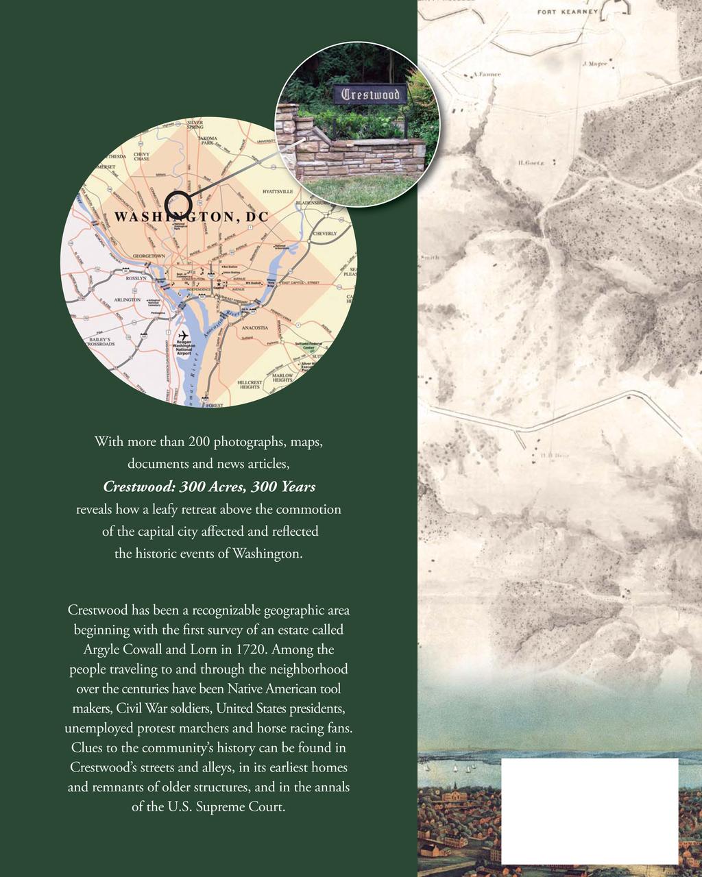
134
A modern street grid superimposed on the cover s 1867 map shows where the old roads and structures would be located in relation to today s Crestwood.
 Blagden Avenue 16th Street A modern street grid superimposed on the cover s 1867 map shows where the old roads and structures would be located in relation to today s Crestwood. Washington West Quadrangle
Hudson Valley Vernacular Architecture Dutch Barn Preservation Society Field Trip to the Palatine Region of the Mohawk Valley May 18, 2013
 Hudson Valley Vernacular Architecture Dutch Barn Preservation Society Field Trip to the Palatine Region of the Mohawk Valley May 18, 2013 Trip Schedule Site Arrive Depart Old Palatine Church 10:30 am 11:15
LOG CABIN (Now at Fiddler s Grove, Lebanon, Tenn.)
") LOG CABIN (Now at Fiddler s Grove, Lebanon, Tenn.) Property and Cabin first owned by Gleaves Family and probably constructed by them John Donelson of the County of Tennessee 640 acres - $600 written 1/11/1796
LOG CABIN (Now at Fiddler s Grove, Lebanon, Tenn.) Property and Cabin first owned by Gleaves Family and probably constructed by them John Donelson of the County of Tennessee 640 acres - $600 written 1/11/1796
An Investigation of a Slave Woman's Role in the Defense of Elkton during the War of 1812
 Prepared for the Historic Elk Landing Foundation An Investigation of a Slave Woman's Role in the Defense of Elkton during the War of 1812 Michael L. Dixon, M.S., M.A. Historian June 12, 2011 Project
Society Member to Supervise the Building of James Monroe s Birthplace House Charles Belfield, a councilor of the War of 1812 Society in the
 Society Member to Supervise the Building of James Monroe s Birthplace House Charles Belfield, a councilor of the War of 1812 Society in the Commonwealth of Virginia has been designated as the supervisor
First Floor Plan. Second Floor Plan
 The Flint Homestead was built by 1709 for Ephraim Flint (1641 1723) and his wife Jane Bulkeley. They did not have any children. In 1723 he willed his mansion house to his nephew, John Flint, and to John
This is the front page of the New York Herald newspaper from April 15, 1912, the day after the ship sank.
 Source #1 This is the front page of the New York Herald newspaper from April 15, 1912, the day after the ship sank. (Source: Wikimedia Commons) Source #2 This is an advertisement for high-quality soap
Lyons. photo by Richard Palmer Layton Road
 Lyons 3532 Layton Road Construction commenced on the Jackson one-room school house at 336 Pleasant Valley Road, Lyons, in 1829. It was completed in 1831 at a cost of $187. It was named for President Andrew
2018 The Friends of Two Rivers Mansion, a 501(c)(3) organization McGavock Pike,
(3) organization McGavock Pike,") NEWSLETTER Number 42 May - June 2018 The Friends of Two Rivers Mansion, a 501(c)(3) organization 3130 - McGavock Pike, President Larry Weber's Remarks - With summer around the corner, let s get ready to
NEWSLETTER Number 42 May - June 2018 The Friends of Two Rivers Mansion, a 501(c)(3) organization 3130 - McGavock Pike, President Larry Weber's Remarks - With summer around the corner, let s get ready to
and led Jimmy to the prison office. There Jimmy was given an important He had been sent to prison to stay for four years.
 O. H e n r y p IN THE PRISON SHOE-SHOP, JIMMY VALENTINE was busily at work making shoes. A prison officer came into the shop, and led Jimmy to the prison office. There Jimmy was given an important paper.
The Lightfoot Tower. Background Information. Librarian Zoé Vallé Memorial Library 63 Regent Street Chester Nova Scotia. July 2007
 1 The Lightfoot Tower Background Information Prepared by: Glen MacLeod Librarian Zoé Vallé Memorial Library 63 Regent Street Chester Nova Scotia July 2007 2 What we know today as the Lightfoot Tower, was
Uncle James Howver The Gold Rush and a Lost Claim
 Uncle James Howver The Gold Rush and a Lost Claim There s Gold in Them Thar Hills! Susan McNelley Some men seek riches. Some men seek adventure. Some men yearn for both. Their stories often stir the imagination.
MCEP Washington DC Trip
 MCEP Washington DC Trip May 18 to 22, 2016 MCEP has created a tour that meets individual needs in a group setting. What is included: Air by Delta Hotel and breakfast Accompanied Guide Entrance fees where
THE MARSDEN FAMILY OF OSSETT AND HORBURY 1. The Old Halfway House and Matty Marsden Lane Horbury - Who was Matty Marsden?
 THE MARSDEN FAMILY OF OSSETT AND HORBURY 1 The Old Halfway House and Matty Marsden Lane Horbury - Who was Matty Marsden? The Old Halfway House Horbury stands at the junction of Westfield Road and Matty
SURVEYORS ADAMS & TWYNAM
 Rusheen s Website: www.rusheensweb.com SURVEYORS ADAMS & TWYNAM Surveyors Philip Francis Adams and Edward Twynam. These two surveyors were responsible for the layout of the town of Wentworth. These are
Mrs. Moore. Titanic Tribute
 Mrs. Moore Titanic Tribute 1912-2012 My name is Margaret Fleming. At the age of 42, I was a 1 st class passenger aboard the Titanic. I was traveling to Haverford, Pennsylvania with my employer, Mrs. Marian
O HARA TOWNSHIP. Chapter 2 - Early History. Comprehensive Development Plan
 O HARA TOWNSHIP Chapter 2 - Early History The O Hara Township History Committee has assembled a significant volume of historical data from primary and secondary sources, about persons, places and events
Maggie s Weekly Activity Pack!
 Maggie s Weekly Activity Pack! Name Date Remembering A Great Adventure The Journey of Lewis and Clark It has been two hundred years since Lewis and Clark started their journey across America. In February
TOWERBUTTE. Lewis and Clark s. >> By Jerry Penry, LS
 4.95 Lewis and Clark s TOWERBUTTE >> By Jerry Penry, LS Have you ever felt like you are standing on hallowed ground, knowing that some very important surveyors had previously occupied that same location?
Panning for History Michael Stahl
 Panning for History Michael Stahl The Young Scout troop went on a camping trip one weekend. The 12 boys and their patrol leader went into the woods close to their home city of Sacramento, located in the
Interviewers: Wynell Schamel and Ed Schamel IntervieweEd Schamel: Lucille Disharoon Cobb. Transcriber: David MacKinnon
 Interviewers: Wynell Schamel and Ed Schamel IntervieweEd Schamel: Lucille Disharoon Cobb Transcriber: David MacKinnon WYNELL SCHAMEL: This interview is with Mrs. Lucille Disharoon Cobb. The date is September
The Early Settlers Revised: September 7, 2013
 The Early Settlers Revised: September 7, 2013 The earliest settlers were farmers. Among the largest farmers in 1860 were: Adams, of which there were several, Phillips, Lynch, Avery, Gere, Garrett and Malloy.
Southeastern Insulation Contractors Association
 Southeastern Insulation Contractors Association Behind the Scenes Tour of Bruton Heights Education Center Monday, October 13, 2014 1:00pm 3:30pm SEICANS will gather in arrival hall at the Lodge where they
SOL VS.2a, 2b, 2c, 10b
 What are the characteristics of the Coastal Plain? 1. Also known as Tidewater 2. Located near the Atlantic Ocean and the Chesapeake Bay 3. Includes the Eastern Shore, a peninsula between the Atlantic Ocean
TRAIN TO MOSCOW HAL AMES
 TRAIN TO MOSCOW HAL AMES Sasha, come to the kitchen. I have something to show you! Papa called out. Just a minute Papa, I ll be right there. I replied to my father as I finished putting on my pants. I
Lewis & Clark Return Home
 Lewis & Clark Return Home On March 23, 1806, Meriwether Lewis, William Clark, and their team started for home. At first they took the same path. But after they crossed the Rocky Mountains, the group split
DANIEL PUTMAN of the Pendleton District South Carolina
 DANIEL PUTMAN of the Pendleton District South Carolina Daniel Putman was my great-great-great-great grandfather and fortunately his life was the best documented of all of Barnet Putman's children. Daniel
Economy 3. This region s economy was based on agriculture. 4. This region produced items such as textiles, iron, and ships in great quantities. For th
 Geography 1. This region has a climate of warm summers and snowy cold winters. 2. This region has a climate that is generally warm and sunny, with long, hot, humid summers, and mild winters, and heavy
Middle Creek a streaming resource
 Middle Creek a streaming resource The Middle Creek Watershed has a long history of human activity. Native Americans used the watershed before the European settlers; they traveled, hunted, and settled in
60 years on, Emmett Till's family visits the site of his "crime" and death
 60 years on, Emmett Till's family visits the site of his "crime" and death By Washington Post, adapted by Newsela staff on 09.13.15 Word Count 941 Spectators observe as members of Provine High School's
Florida discoveries: Princess Place full of history & beauty
 Page 1 of 5 Florida Travel AUGUST 21, 2015 Florida discoveries: Princess Place full of history & beauty i BY BONNIE GROSS FloridaRambler.com Funky Florida will always find ways to surprise you. Page 2
People of the Nile 5. Lesson Objectives. Core Content Objectives. Language Arts Objectives
 People of the Nile 5 Lesson Objectives Core Content Objectives Students will: Locate Egypt on a world map or globe and identify it as a part of Africa Explain the importance of the Nile River and how its
First Generation. Second Generation. Third Generation
 17 February 2014 First Generation 1. Location: in Clover Creek area, Highland County, VA Bullpasture Valley, 2 miles above Clover Creek about 1752. 1 Robert GRAHAM 2 died about 1771;. 3 Robert GRAHAM had
Eli Pousson Baltimore Heritage in partnership with the National Trust for Historic Preservation May 27, 2010
 Eli Pousson Baltimore Heritage in partnership with the National Trust for Historic Preservation May 27, 2010 DRAFT Report on 3000 block of North Avenue DRAFT The Dr. Zepp Mansion is a late 19th century
1. Title slide: Great Wagon Roads
 1. Title slide: Great Wagon Roads a. Going to discuss how our ancestors may have come to South Carolina b. Of course could have come aboard ship to Charleston c. Many came overland from the more northern
The Tanska Resort and Family Tanska Auto Camp
 The Tanska Resort and Family Tanska Auto Camp The Tanska Auto Camp was an early twentieth-century retreat located on the northwestern shore of Pine Lake on the Sammamish Plateau (King County), operating
Maryland Historical Trust Inventory No. 15/6 Maryland Inventory of Historic Properties Form
 Inventory No. 15/6 Maryland Inventory of 1. Name of Property (indicate preferred name) historic Becraft Farm other 2. Location street and number 28500 Ridge Road not for publication city, town Mount Airy
the spider bites Med or a sale
 the spider bites Med or a sale the spider bites Med o r a sale Copyright 2010 Medora Sale All rights reserved. No part of this publication may be reproduced or transmitted in any form or by any means,
The History of a Floodplain Meadow Bridget Smith
 The History of a Floodplain Meadow Bridget Smith I have lived in the village of Hemingford Grey near the River Great Ouse since 1976 and, like many others, walked the 1½ km into St Ives by the ancient
YORKSHIRE GARDENS TRUST
 YORKSHIRE GARDENS TRUST Hambleton District Historic Designed Landscapes Project Aldwark Manor Report by Louise Wickham[July 2017] 1. CORE DATA 1.1 Name of site: Aldwark Manor 1.2 Grid reference: SE 469630
State Level Historic Documentation Report. John Blue Bridge Hampshire County
 State Level Historic Documentation Report State Project No. S314-28-22.27 Federal Project No. BR-0028(058)D John Blue Bridge Hampshire County Prepared by: Randy Epperly, Historian Department of Transportation
Section 1: Vocabulary. Be able to determine if the word in bold is used correctly in a sentence.
 Section 1: Vocabulary. Be able to determine if the word in bold is used correctly in a sentence. Hardships: difficult conditions or situations that cause discomfort and/or suffering Pioneers: the people
The BMW Club - National AGM 2018
 The BMW Club - National AGM 2018 Saturday 14th April Dunchurch Park Hotel & Conference Centre For some months the venue of the 2018 National AGM has been advertised in The Journal. Previous AGM's have
Narragansett School The History of the Murals at Narragansett School
 Narragansett School The History of the Murals at Narragansett School These murals, running east to west, are intended to present brief pictorial history of selected places and events from Gorham's past.
CHRONOLOGY & DEVELOPMENT BOUDINOT-SOUTHARD PROPERTY BASKING RIDGE, NJ OF THE
 CHRONOLOGY & DEVELOPMENT OF THE BOUDINOT-SOUTHARD PROPERTY BASKING RIDGE, NJ Elias Boudinot 1740 Elias Boudinot born May 2 in Philadelphia, where his family was a neighbor of Benjamin Franklin. 1760 Boudinot
Learning Places Spring 2016 LIBRARY / ARCHIVE REPORT #1 Brooklyn Public Library. Carlos Merced INTRODUCTION PRE-VISIT REFLECTION
 Learning Places Spring 2016 LIBRARY / ARCHIVE REPORT #1 Brooklyn Public Library Carlos Merced 02.29.2015 INTRODUCTION The Brooklyn Public Library has thousands of public programs, extensive book collections,and
Lost Colony of Roanoke
 Lost Colony of Roanoke Lesson Number: 3 Title: The Lost Colony of Roanoke Grade Level: 5 th Time: 50-60 minutes Materials: Per Student: Roanoke: The Lost Colony short story Roanoke Theories worksheet Evidence
Middle Row: Part of a Georgian Industrial Settlement in Cark in Cartmel, Cumbria Les Gilpin
 Middle Row: Part of a Georgian Industrial Settlement in Cark in Cartmel, Cumbria Les Gilpin The Georgian rows of of High Row and Low Row which sit alongside ' Cark Beck' (river Eea) in the hamlet of Cark
Plantation House Hotel
 Preservation South Carolina Request for REDEVELOPMENT PROPOSALS for the Plantation House Hotel Edgefield, South Carolina The History of the Dixie Highway / Plantation House Hotel The early 1890s found
BRADDOCK'S WAR SUPPLIES AND DUNBAR'S CAMP 1
 I934 braddock's war supplies 49 BRADDOCK'S WAR SUPPLIES AND DUNBAR'S CAMP 1 /-\u25a0-a he following is the story of how the war supplies of General JL Braddock, which he discarded in his hasty retreat
Late-nineteenth-century view of the Macy house on Liberty Street GPN2044. Nantucket Historical Association
 MACY-CHRISTIAN OLDEST HOUSE HOUSE Late-nineteenth-century view of the Macy house on Liberty Street GPN2044 10 Nantucket Historical Association MACY-CHRISTIAN» OLDEST HOUSE Macy-Christian House In the early
The Age of European Expansion
 The Age of European Expansion 1580-1760 Spanish and Portuguese America 1581-1640 1. The Viceroyalty of New Spain was first established in 1535 by King Charles I 1 2. The 15 Captaincies of Brazil were first
Personal History. Curiosity Creek on the end of Jenal Road in 2003 (USF) Curiosity Creek in 2003 (USF)
 Curiosity Creek in 2003 (USF)") Oral history narrative from a joint program with Hillsborough County and the Florida Center for Community Design and Research Curiosity Creek The following narrative comes from an interview with long-time
Oral history narrative from a joint program with Hillsborough County and the Florida Center for Community Design and Research Curiosity Creek The following narrative comes from an interview with long-time
National Parks Called America s Best Idea
 National Parks Called America s Best Idea Welcome to This Is America in VOA Learning English. I'm Jim Tedder. And I'm Kelly Jean Kelly. This week on our program, we talk about national parks in the United
Roman Expansion: From Republic to Empire
 Roman Expansion: From Republic to Empire January 6 January 10, 2014 I will be able to analyze the political and social institutions of the Roman Republic. I will then be able determine and collaboratively,
Crabtree Publishing Company
 By Gary Miller Company www.crabtreebooks.com Author: Gary Miller Editor: Barbara Bakowski Designer: Tammy West, Westgraphix LLC Photo Researcher: Edward A. Thomas Map Illustrator: Stefan Chabluk Indexer:
SAN RAMON A SHORT HISTORY
 SAN RAMON A SHORT HISTORY A COMMUNITY BEGINS Today San Ramon is a dynamic young city, one of California's outstanding urban villages. It has a variety of homes, parks and stores and a major employment
Springtime in D.C. Segway Blossom festivities
 Springtime in D.C. It is here at last: the Washington D.C. spring, when America s capital bursts into color. We can ride a bus, a bicycle, a Segway, a horse-drawn carriage, a taxi or a pedicab around the
MP : The Empire Toll Gate and Glen Arbor
 MP 255 256: The Empire Toll Gate and Glen Arbor This section includes the location of the Empire Toll Gate, Glen Arbor and a reservoir. Route Mile Marker X Y Longitude Latitude 1 U. S. Highway 40 255 439593.25
THE USA. The capital of USA is Washington D.C., in the District of Columbia.
 THE USA The United States of America is the richest and one of the biggest countries in the world. It has a population of about 295 million people. It is divided into 50 states; two of them, Alaska and
History Reclaimed: Authentic American Vintage Lumber from the Parker Dexter 1840 s Barn in Topsham, VT
 History Reclaimed: Authentic American Vintage Lumber from the Parker Dexter 1840 s Barn in Topsham, VT Immigration Thomas Dexter was born in England and immigrated to the New World in 1629 or 1630, bringing
I. Course venue: Preston Auditorium, 1818 H Street, N.W. Washington DC, 20433
 2017 OVERVIEW COURSE OF FINANCIAL SECTOR ISSUES Finance and Risk in a Global Environment June 19-23, 2017 World Bank Group, - Main Complex - Preston Auditorium 1818 H. Street, N.W. Washington, D.C. 20433
MAIN CHARACTERS. BASIL HALLWARD A successful and talented artist who paints the picture mentioned in the title.
 MAIN CHARACTERS BASIL HALLWARD A successful and talented artist who paints the picture mentioned in the title. DORIAN GRAY We first meet Dorian when he is about twenty. He is young, handsome and very rich.
The Natchez Trace The DAR and its Tishomingo County Connection
 The Natchez Trace The DAR and its Tishomingo County Connection Presented By Cindy Whirley Nelson, Chapter Regent, 2006-2008, Chief Tishomingo Chapter DAR Since the time pre-historic tribes roamed the hills
Spanish Land Grant History of Santa Teresa and Sunland Park Abridged by Dr. Paul Maxwell Taken from the NM Office of the State Historian
 Spanish Land Grant History of Santa Teresa and Sunland Park Abridged by Dr. Paul Maxwell Taken from the NM Office of the State Historian Introduction: Ownership of what now encompasses the Sunland Park
A Bridge to the Past: The Euharlee Covered Bridge Written By Amanda Closs Edited for web application by Judi Irvine
 A Bridge to the Past: The Euharlee Covered Bridge Written By Amanda Closs Edited for web application by Judi Irvine When I first started my research, someone suggested that I get on the Internet and look
SOME 19th Cent. SHIPPING RECORDS re BYERS
 SOME 19th Cent. SHIPPING RECORDS re BYERS Liberty, 1802 From? arriving in Philadelphia, Pennsylvania, on 28 May 1802. Likely the brig, Liberty, built in Scarborough in 1785 by John Fowler. Bartholomew
GRAVE OF EVA AMELIA HEWITT MUNROE
 GRAVE OF EVA AMELIA HEWITT MUNROE Adjacent to 2875 Me FARLANE ROAD october 6, 2009 Historic and Environmental Preservation Board City of Miami GRAVE OF EVA EMELliA HEVV~TT MUNROE ADJACENT TO 2875 MCFARLANE
Fort Ticonderoga Carillon Battlefield Walking Trail Guide
 Fort Ticonderoga Carillon Battlefield Walking Trail Guide Copyright Fort Ticonderoga. Photo Credit Carl Heilman II Length: Approximately 1¾ mile Welcome to Fort Ticonderoga s Walking Trail Blue markers
THE BARNACLE 3485 MAIN HIGHWAY
 THE BARNACLE 3485 MAIN HIGHWAY Designation Report City of Miami REPORT OF THE CITY OF MIAMI PLANNING AND ZONING DEPARTMENT TO THE HISTORIC AND ENVIRONMENTAL PRESERVATION BOARD ON THE POTENTIAL DESIGNATION
My Life Since Brymore June 2014
 Roy P. Masson Brymore 1955-1958 I was born in Aberdeen, Scotland in 1942. In the winter of 1947 my family moved to Silverton Mills, near Exeter in Devon, with my father getting a job of Head of Construction
People of Yesterday. Text: David Gibbs
 People of Yesterday Text: David Gibbs A collection of photographs of villagers of yesterday, with the emphasis on dress and appearance, and also recognising, where known, their contribution to village
Unit 5: Selling of the American West
 Unit 5: Selling of the American West Announcements: midterms handed back assignment folder update posted next week turning in assignment folder June 12th Unit 5: Age of Exploration North America Thomas
TOWNSHIP OF HILLSIDE, NJ.
 TOWNSHIP OF HILLSIDE, NJ. HILLSIDE Formed as Township: 1913 1970 Population: 21,636 Land Area 2.70 square miles The initial settlement of the township now known as present day Hillside followed shortly
Eagle Harbor (PG 87B-038)
") Eagle Harbor (PG 87B-038) The resort community of Eagle Harbor began to develop in the 1920s at the site of an ancient river port, Trueman Point (87B-028), on the Patuxent River. 1 Eagle Harbor is located
Eagle Harbor (PG 87B-038) The resort community of Eagle Harbor began to develop in the 1920s at the site of an ancient river port, Trueman Point (87B-028), on the Patuxent River. 1 Eagle Harbor is located
The voyage of the 'Mimosa', By Culturenet Cymru
 www.casgliadywerincymru.co.uk www.peoplescollectionwales.co.uk Learning Activity Key Stage 3 This resource provides learning activities for your students using People's Collection Wales. It is one of a
Five-Figure Finder-Fees Locating Unclaimed Funds
 OveragesBlueprint.com Presents. The Insider s Guide to Five-Figure Finder-Fees Locating Unclaimed Funds www.overagesblueprint.com Diamond Law Center, LLC Legal Disclaimer This report is intended to provide
Capitol Hill Interviews
 Freda Murray was interviewed in 1974 to provide background for the application to create the Capitol Hill Historic District. Citation of this material should include this information and cite the Ruth
From Die Laughing (The BIT'N Files Series), by T. L. Wolfe, 2005, Austin, TX: PRO-ED. Copyright 2005 by PRO-ED, Inc. BIT N File One. Thadd L.
, by T. L. Wolfe, 2005, Austin, TX: PRO-ED. Copyright 2005 by PRO-ED, Inc. BIT N File One. Thadd L.") Thadd L. Wolfe Author Thadd L. Wolfe Cover Illustration Larry Knighton The BIT N Files Series was created by Stephen Cosgrove. 2005, 1998 by Stephen Cosgrove. No part of this publication may be reproduced,
Thadd L. Wolfe Author Thadd L. Wolfe Cover Illustration Larry Knighton The BIT N Files Series was created by Stephen Cosgrove. 2005, 1998 by Stephen Cosgrove. No part of this publication may be reproduced,
EARLY PEOPLE OF ITALY. Chapter 9: The Ancient Romans
 EARLY PEOPLE OF ITALY Chapter 9: The Ancient Romans INTRO: The Italian peninsula is a mountainous land, shaped like a highheeled boot. Many different people migrated to the Italian peninsula through many
next purchase at Antelope Springs Ranch. These centrally located parcels are strategically positioned between Roswell and Artesia, New Mexico.
 Wide open spaces and beautiful sunsets! That s what you get when you make your next purchase at Antelope Springs Ranch. These centrally located parcels are strategically positioned between Roswell and
Married: Thursday evening, Jan. 4, at 6 o'clock, Miss Sybil Ball and Mr. Benj. Ellis both of this city.
 Maple Hill Cemetery index for the Sawtell addition, block 3, lot 66, graves 5-7, Ben Ellis family Married: Thursday evening, Jan. 4, at 6 o'clock, Miss Sybil Ball and Mr. Benj. Ellis both of this city.
Redsecker Residence: 244 South Market Street; Elizabethtown, Pennsylvania
 Hon 170: Elizabethtown History: Campus and Community Joseph Santos Professor Benowitz 5 May 2017 Redsecker Residence: 244 South Market Street; Elizabethtown, Pennsylvania Abstract: The Redsecker Residence,
Rosa Gonzales stood on the porch of her humble
 Chapter 1 A JOB FOR LUIS Rosa Gonzales stood on the porch of her humble dwelling. The small wooden building, half hidden by trees, nestled among the mountains of Caguas, Puerto Rico. The weather-beaten
Marland s Grand Home Centennial Articles June to 1970
 Marland s Grand Home Centennial Articles June 2016 1960 to 1970 ************************************************************************************* Note: Sixth in a series of twelve monthly articles
Fall Member Trip Historic New York City and the Hudson River Valley September 24-29, 2018
 Fall Member Trip Historic New York City and the Hudson River Valley September 24-29, 2018 Day 1: Monday, September 24 - Preview to the Hudson River Valley Enjoy the scenic views as you travel up the Hudson
Warriston Cemetery, Edinburgh, Scotland, War Graves
 Warriston Cemetery, Edinburgh, Scotland, War Graves Lest We Forget World War 1 TEMPORARY SURGEON PROBATIONER C. HORDERN ROYAL NAVAL VOLUNTEER RESERVE 21ST JUNE, 1915 AGE 25 Cedric HORDERN Cedric Hordern
Largest cities in the United States by population by decade
 1 of 17 11/15/2008 7:30 AM Largest cities in the United States by population by decade From Wikipedia, the free encyclopedia This entry tracks and ranks the population of the largest cities in the United
OLD ORCHARD BEACH. 7/26/1907 Beach. Baptists, was first man to build a summer cottage at Ocean Park and died in it. No date given.
 SUBJECT SUBJ1 DESCRIPTION CITATION CITATION DATE Ocean Park Opened 1880. Deacon E. R. Wade, 83, dies at Ocean Park. Was deacon in Free 7/26/1907 Baptists, was first man to build a summer cottage at Ocean
Maastricht is a city whose history stretches back many centuries. It has been :
 EPSA 2011 Best Practice Certificates, 15 November, 18.30 hrs Ladies and gentlemen, On behalf of the municipal government, I am delighted to welcome you officially, here in the beautiful town hall of Maastricht.
Sebastian Vizcaiňo
 Sebastian Vizcaiňo 1548-1629 Sebastian Vizcaiňo was a California explorer who was more famous for what he named, or rather renamed, than for what he found. In truth, he didn t discover anything that Cabrillo
California Explorer Series
 California Explorer Series Sebastian Vizcaino 1548-1629 Sebastian Vizcaino was a California explorer who was more famous for what he named, or rather renamed, than for what he found. In truth, he didn
Student Activities. Dead Man s Folly. Part 1 (Chapters 1 3) 3 Vocabulary Match the words on the left with their definitions on the right.
 3 Vocabulary Match the words on the left with their definitions on the right.") Part (Chapters ) Vocabulary Complete the labels on the map of Nasse House. KEY Woodland and bushes Station Hoodown Park Front gates Drive ennis court Nasse House ea tent Upper garden Fortuneteller s tent
Part (Chapters ) Vocabulary Complete the labels on the map of Nasse House. KEY Woodland and bushes Station Hoodown Park Front gates Drive ennis court Nasse House ea tent Upper garden Fortuneteller s tent
MP : The Big Chief Overlook and the Glen
 MP 253 254: The Big Chief Overlook and the Glen The mile between MP 253 and 254 has lots of history in it. It includes the only recorded remains of the Victory Highway on the Clear Creek County side of
Niehaus/Nienhueser Family Information
 Niehaus/Nienhueser Family Information Information contributed by Wolfgang Dreuse (2011) Lithograph of Buer All the children of Franz and Elsa (or their grandchildren) came to America except for the oldest
Francis Family Bus Tour July 16, 1999
 Francis Family Bus Tour July 16, 1999 Thank you for joining us. We have prepared a brief synopsis of the points of interest that we will see today. We are pleased to have Earl and Marjorie Lindsay along
Springtime in D.C. 1 learningenglish.voanews.com Voice of America
 Springtime in D.C. It is here at last: the Washington D.C. spring, when America s capital bursts into color. We can ride a bus, a bicycle, a Segway, a horse-drawn carriage, a taxi or a pedicab around the
Langford Road, East Candia. East Candia. A Walking Tour. Published by Candia Heritage Commission September 2013
 Langford Road, East Candia East Candia A Walking Tour Published by Candia Heritage Commission September 2013 Methodist Church In 1894, the Methodist Society built a church at what is today 163 Langford
KILLMACHRENAN. By: Lawrence J. Fleenor, Jr. & Edgar A. Howard. Copyright & All Rights Reserved: Lawrence J. Fleenor, Jr. Big Stone Gap, Va.
 KILLMACHRENAN By: Lawrence J. Fleenor, Jr. & Edgar A. Howard Copyright & All Rights Reserved: Lawrence J. Fleenor, Jr. Big Stone Gap, Va. March 2015 An Essay for the Daniel Boone Wilderness Trail Assn.
Samuel Treat ( /17)
") Samuel Treat (1648 1716/17) Samuel Treat graduated from Harvard College in 1669. He was the eldest son of Robert Treat who became governor of Connecticut. He was the husband of Elizabeth Mayo who was the
Samuel Treat (1648 1716/17) Samuel Treat graduated from Harvard College in 1669. He was the eldest son of Robert Treat who became governor of Connecticut. He was the husband of Elizabeth Mayo who was the