REVISED PLANNING PROPOSAL Volume syw082 Station Stret, Menangle
|
|
|
- Hope Franklin
- 5 years ago
- Views:
Transcription
1 REVISED PLANNING PROPOSAL Volume syw082 Station Stret, Menangle
2
3 Part 4 Mapping Existing Controls in the Wollondilly LEP 2011 affecting the Site Zone / Standard Zone Control The land is zoned RU1 Primary Production. The objectives of the RU1 Zone To encourage sustainable primary industry production by maintaining and enhancing the natural resource base. To encourage diversity in primary industry enterprises and systems appropriate for the area. To minimise the fragmentation and alienation of resource lands. To minimise conflict between land uses within this zone and land uses within adjoining zones. To provide for a range of land uses (including tourism-related uses) that support the agriculture industry. Height Minimum Lot Size Heritage To provide areas within which the density of development is limited in order to maintain a separation between urban areas. There are no height controls on the site. 100ha The subject site contains the following heritage items, identified as items of local significance in Schedule 5 of the Wollondilly LEP 2011: Item I100: Camden Park Estate Central Creamery, 45 Stevens Road, Part Lot 21, DP581462; Item I83: Camden Park Rotolactor, 15 Menangle Road, Part Lot 201, DP590247; Item I97: Dairy Cottage, 1370 Moreton Park Road, Part Lot 202, DP Additionally, part of the site is located within the Menangle Conservation Area and it is the vicinity of the following heritage items, grouped as being immediately adjacent to, and located at some distance from, the subject site. Planning Proposal Station Street Menangle 71

4 Figure 16 Current Zoning Map 72 Planning Proposal Station Street Menangle


5 Figure 17 Current Heritage Map Planning Proposal Station Street Menangle 73
6 Existing controls in the Wollondilly LEP 2011 affecting the surrounding area Zone / Standard Location Control Zone surrounds R2 Low Density Residential B1 Neighbourhood Centre Height Land in R2 zone RE1 Public Recreation 6.8m Minimum Lot Size Land in B1 zone Adjacent residential subdivision and northern part of Menangle Village Southern part of Menangle Village 9m 975sqm 1250sqm Adjacent Heritage Items»» Item I82: Camden Park Estate-Central Creamery Manager s Cottage, 15 Menangle Road, Part Lot 201, DP »» Item I81: Menangle Railway Station Group, Station Street (Main Southern Railway)»» Item I86: Bungalow, 92 Menangle Road, Lot A, DP »» Item I87: Bungalow, 96 Menangle Road, Lot 1, DP »» Item I88: House, 100 Menangle Road, Lot 1, DP »» Item I89: Cottage, 102 Menangle Road, Lot A, DP »» Item I90: Bungalow, 106 Menangle Road, Lot B, DP The Menangle Railway Station Group is also listed as an item of State Significance on the NSW State Heritage Register, and is included in the NSW Railcorp S170 Heritage and Conservation Register. Other Heritage Items in the surrounding area include:»» Item I98: Menangle Store, 2 Station Street, Lot 8, DP »» Item I91: St Patrick s Catholic Church, 119 Menangle Road, Lot 100, DP »» Item I92: Cottage, 124 Menangle Road, Lot 1, DP »» Item I93: Cottage, 128 Menangle Road, Lot B, DP »» Item I94: St James Anglican Church, 131 Menangle Road, Lot 1, DP »» Item I80: Menangle Rail Bridge over Nepean River, Menangle Road (Main Southern Railway)»» Item I101: Menangle Weir, Station Street, Lot 2, DP The Menangle Rail Bridge is also listed as an item of State significance on the NSW State Heritage Register, and is included in the NSW Railcorp S170 Heritage and Conservation Register. St James Anglican Church is a prominent heritage item of local significance in Menangle Village. It is sited on a hill to the south of the subject site. 74 Planning Proposal Station Street Menangle
7 Proposed LEP maps Figure 18 Proposed Land Zoning Map SP2 MENANGLE ROAD LAND ZONING MAP LAND TO WHICH THIS PLAN APPLIES B1 R2 SP2 NEIGHBOURHOOD CENTRE LOW DENSITY RESIDENTIAL INFRASTRUCTURE R2 B1 R2 B1 R2 WOODBRIDGE ROAD STATION STREET R2 Source Cox MORETON PARK ROAD R2 R2 H WESTERN FREEWAY) Planning Proposal Station Street Menangle 75
8 Figure 19 Proposed Height of Buildings Map MENANGLE ROAD MAXIMUM BUILDING HEIGHT MAP LAND TO WHICH THIS PLAN APPLIES F 6.8 METRES J 9.0 METRES J F J WOODBRIDGE ROAD STATION STREET J MORETON PARK ROAD J J HUME HWY (SOUTH WESTERN FREEWAY) 76 Planning Proposal Station Street Menangle
9 Figure 20 Proposed Lot Size Map MENANGLE ROAD MINIMUM LOT SIZE MAP LAND TO WHICH THIS PLAN APPLIES C 250 sq m G I 450 sq m 500 sq m G C I G WOODBRIDGE ROAD STATION STREET C G MORETON PARK ROAD G G HUME HWY (SOUTH WESTERN FREEWAY) Planning Proposal Station Street Menangle 77
10 Figure 21 Proposed Urban Release Area Map MENANGLE ROAD Urban Release Map Urban Release Area Cadastre WOODBRIDGE ROAD STATION STREET MORETON PARK ROAD HUME HWY (SOUTH WESTERN FREEWAY) 78 Planning Proposal Station Street Menangle
11 Part 5 Community consultation Part 6 Project timeline The project timeline will be determined by the RPA. Consultation prior to gateway determination Pursuant to Council policy, initial notification was given to nearby and potentially affected land owners in May A summary of the issues raised are set out in Council s assessment report for the 15 October 2012 Council meeting (refer to annex A). The applicant has a history of seeking community input through public meetings and online. Future consultation following the gateway determination This planning proposal does not fall within the definition of low impact planning proposal set out in section of A Guide to Preparing Local Environmental Plans. As such the minimum exhibition period is 28 days. Notification of the formal public exhibition will be in accordance with section of the Guide. Table 10 Action Project timeline Anticipated commencement date (date of Gateway determination) Anticipated timeframe for the completion of required technical information Timeframe for government agency consultation Commencement and completion dates for public exhibition period Dates for public hearing Timeframe for consideration of submissions Timeframe for consideration of a proposal post exhibition Date of submission to the department to finalise the LEP Anticipated date RPA will make the plan Anticipated date RPA will forward to the department for notification Timing 9 December 2014 July Days Determined by the RPA Determined by the RPA Determined by the RPA Determined by the RPA Determined by the RPA Determined by the RPA Determined by the RPA Planning Proposal Station Street Menangle 79
12 80 Planning Proposal Station Street Menangle

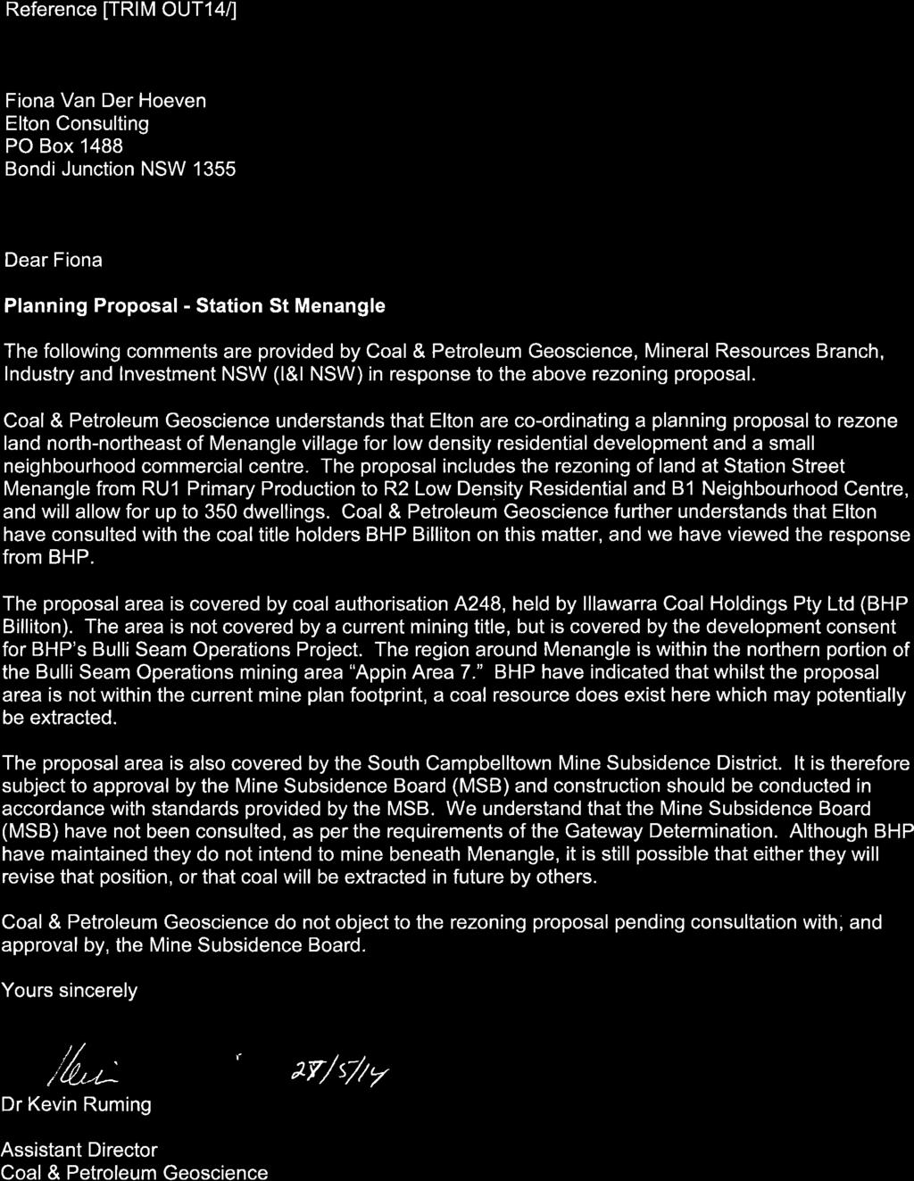
13 Appendices A B C Gateway Determination Public Open Space and Landscape Concept Plan Mine Subsidence Correspondence [Title] Elton Consulting 1
14 A Gateway Determination 2 Planning Proposal Elton Consulting


15

16

17


18
19 B Public Open Space and Landscape Concept Plan Planning Proposal Elton Consulting 3


20 Road reserve ( type 3) Road reserve ( type 2) 10 4 Neighbourhood park ( East ) Area:3379m² Schedule of Elements Concrete pathways Play area Shelters with seating Seating BBQ facilities Community gathering space/forecourt Community gardens Lighting/Furniture Structural Tree planting Recreational open space Informal turfed open space Heritage interpretation play equipment Native regeneration Rate m2 / l/m 200l/m 250m2 1 item 5 item 1 item 260m2 item item item 1250m2 100m2 item 200m2 Note the following schedule is Work In Progress and for estimation purposes only based on intial concept sketch. Refer to 14513_Quantity estimates_neighborhood park East REFERENCE PLAN LEGEND Community gardens Shelter / BBQ Facilities Play Area MENANGLE STATION Entry points Recreational Open space 8 6 Informal lawn space Courtyard Gardens Road reserve ( type 2) Existing Alluvial Bush land 8 Bushland walk: Extention into alluvial woodlands 9 Native regeneration to existing alluvial woodlands 10 Ground cover/ shrub planting 9 8 Hume highway William Street East Sydney NSW 2011 PO Box A866 Sydney South NSW 1235 T F E. context@context.net.au Scale 0 A m 40 Project Ref: Dwg No: LSK001 Date: 13 June 2014 Client: Neighbourhood Park East concept Menangle Pastoral


21 Precedent Images / Character Community gardens Play Area Informal lawn space Playground Woodland edge pathway Open recreational space William Street East Sydney NSW 2011 PO Box A866 Sydney South NSW 1235 T F E. context@context.net.au Project Ref: Dwg No: LSK001 Date: 13 June 2014 Client: Neighbourhood Park East concept Menangle Pastoral


22 4 Road reserve ( type 4) MENANGLE STATION Menangle Road Cottage 4 REFERENCE PLAN LEGEND 7 5 Adjacent Creamery Buildings 1 2 Community gardens / Orange grove Shelter / BBQ Facilities Play Area Entry points 5 5 Informal lawn space maintaining views to open space 6 Courtyard Gardens with feature planting Heritage walk 8 Ground cover/ shrub planting Adjacent Creamery Land Neighbourhood park ( West ) Area:14 045m² Road reserve ( type 4) Schedule of Elements Concrete pathways Play area Shelters with seating Seating BBQ facilities Community gathering space/forecourt Community gardens / orchard grove Lighting/Furniture Structural Tree planting Informal turfed open space Heritage interpretation play equipment Creamery interpretation artwork and play equipment Rate m2 / l/m 520l/m 550m2 1 item 8 item 1 item 530m2 item item item 4300m2 item item 4 Note the following schedule is Work In Progress and for estimation purposes only based on intial concept sketch Refer to 14513_Quantity estimates Neighborhood park East William Street East Sydney NSW 2011 PO Box A866 Sydney South NSW 1235 T F E. context@context.net.au Scale 0 A m 80 Project Ref: Dwg No: LSK002 Date: 13 June 2014 Client: Neighbourhood Park West concept Menangle Pastoral


23 Precedent Images / Character Community gardens Orchard grove Shelter / BBQ Facilities Informal recreational open space Heritage walk In formal play Area Interpretation themed play / sculpture William Street East Sydney NSW 2011 PO Box A866 Sydney South NSW 1235 T F E. context@context.net.au Project Ref: Dwg No: LSK002 Date: 13 June 2014 Client: Neighbourhood Park West concept Menangle Pastoral
24 C Mine Subsidence Correspondence 4 [Title] Elton Consulting
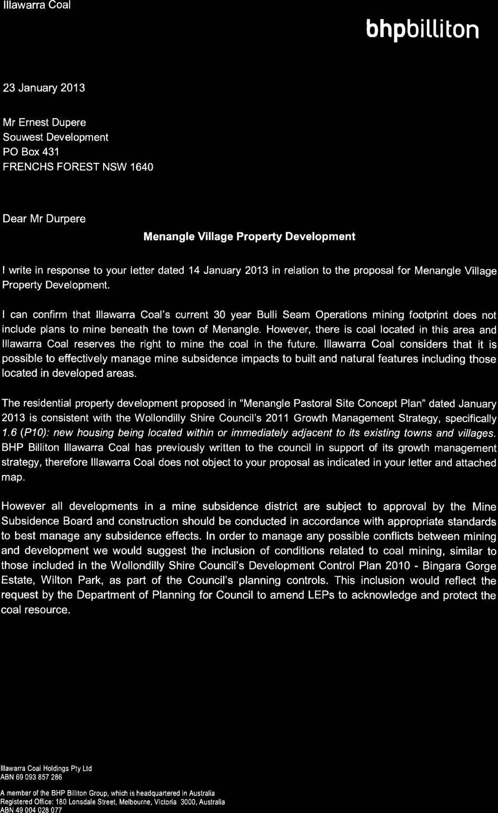


25
26
27


28


29
30
31
32 Planning Proposal Station Street Menangle 81
33 82 Planning Proposal Station Street Menangle
State Environmental Planning Policy (Sydney Region Growth Centres) Amendment (Catherine Fields Precinct) 2013
 Amendment (Catherine Fields Precinct) 2013") New South Wales (Sydney Region Growth Centres) Amendment (Catherine Fields Precinct) 2013 under the Environmental Planning and Assessment Act 1979 Her Excellency the Governor, with the advice of the Executive
New South Wales (Sydney Region Growth Centres) Amendment (Catherine Fields Precinct) 2013 under the Environmental Planning and Assessment Act 1979 Her Excellency the Governor, with the advice of the Executive
THE GATEWAY TO THE SOUTH WEST.
 LIFE S A BREEZE. Live in the heart of a living, breathing community where everything you need is already in abundance. Experience a master planned neighbourhood with a real sense of place a stone s throw
TOWN PLANNING SUBMISSION TO THE GREATER SYDNEY COMMISSION LANDS AT ARTARMON
 TOWN PLANNING SUBMISSION TO THE GREATER SYDNEY COMMISSION LANDS AT ARTARMON March 2017 TABLE OF CONTENTS 1.0 INTRODUCTION 3 2.0 THE SUBJECT SITE 4 3.0 STRATEGIC PLANNING CONTEXT 6 4.0 SUMMARY AND CONCLUSIONS
PO Box 257 PO Box 257 PARRAMATTA NSW 2124 PARRAMATTA NSW 2124
 31 March 2017 Sean O Toole Sheridan Dudley District Commissioner - West District Commissioner - South West Greater Sydney Commission Greater Sydney Commission PO Box 257 PO Box 257 PARRAMATTA NSW 2124
Riverbank Precinct Footbridge
 The Adelaide City Council invites feedback from the community about the Riverbank Precinct Footbridge Project Summary The Riverbank Precinct Footbridge is a State Government initiated project involving
Welcome WINSTON GROUP. Welcome to our public exhibition on the Winston Group s proposals to redevelop 110 Walm Lane, Willesden Green.
 Welcome Our proposed scheme (image for illustrative purposes only) Welcome to our public exhibition on the Winston Group s proposals to redevelop 110 Walm Lane, Willesden Green. The purpose of our exhibition
Submission in response to. Towards our Greater Sydney 2056
 Submission in response to Draft District Plans Towards our Greater Sydney 2056 Prepared by Mirvac Homes (NSW) Pty Limited March 2017 Introduction Mirvac supports the development of a strategic framework
Plaquing Nomination for Thornleigh Quarry & Zig Zag Railway Page 2 LOCALITY PLAN 3 SITE MAP 4 PLAQUE NOMINATION FORM 6
 Plaquing Nomination for Thornleigh Quarry & Zig Zag Railway Page 2 Contents INTRODUCTION 3 LOCALITY PLAN 3 SITE MAP 4 PLAQUE NOMINATION FORM 6 PLAQUING NOMINATION ASSESSMENT FORM 7 1 BASIC DATA 7 2 ASSESSMENT
Signature Project Scheme in Central & Western District: Harbourfront Enhancement and Revitalisation ( HEAR ) at the Western Wholesale Food Market
 at the Western Wholesale Food Market") For discussion on 7 June 2013 Signature Project Scheme in Central & Western District: Harbourfront Enhancement and Revitalisation ( HEAR ) at the Western Wholesale Food Market PURPOSE This paper seeks
For discussion on 7 June 2013 Signature Project Scheme in Central & Western District: Harbourfront Enhancement and Revitalisation ( HEAR ) at the Western Wholesale Food Market PURPOSE This paper seeks
COUNCIL REPORT Meeting Date: December 10, 2013
 Subject: Highway 63/881 Corridor Area Structure Plan Amendment Bylaw No. 13/037 APPROVALS: Felice Mazzoni, Director Henry Hunter, Executive Director Glen Laubenstein, Chief Administrative Officer COUNCIL
Appendix F Public authorities responses
 Planning Proposal under sec 55 of the EP&A Act LEP Refinements Appendix F Public authorities responses Appendix F Public authorities responses Prior to public exhibition, consultation was made with the
Draft Greater Sydney Region Plan
 Powered by TCPDF (www.tcpdf.org) Draft Greater Sydney Region Plan Submission_id: 31119 Date of Lodgment: 12 Dec 2017 Origin of Submission: Online Organisation name: Serapark Pty Ltd Organisation type:
SOUTH INTERCHANGE AREA
 Santaquin City General Plan 1 Location and Characteristics The South Interchange Area of Santaquin is located west of Interstate 15 and south of 500 South (Figure 1). It includes properties already annexed
SIT BACK AND WATCH THE WORLD GO BY. FROM A CORNER THAT S ALL YOUR OWN.
 SIT BACK AND WATCH THE WORLD GO BY. FROM A CORNER THAT S ALL YOUR OWN. Welcome to Luminous Garden A new kind of residence in Edmondson Park The only address to call home Blue Mountains National Park Forest
Rich History, Bright Future
 CRAFTED BY AOYUAN Rich History, Bright Future Space to Breathe A Proud Heritage Re-Imagined Coomeroo Estate delivers that longed-for space to breathe, freedom to move and room for your family to grow.
Blue Mountains Heritage Register Review
 Address: 31 and 44 De Quency Road and 34-48 Genevieve Road Suburb / Nearest Town: Bullaburra 2784 Local Govt Area: State: Blue Mountains NSW DUAP Region: Sydney West Historic region: Sydney Parish: Jamison
Date: 11 th January, From: Plaistow & Ifold Parish Neighbourhood Plan - Steering Group. Plaistow & Ifold Parish Council
 Date: 11 th January, 2017 From: Plaistow & Ifold Parish Neighbourhood Plan - Steering Group To: Plaistow & Ifold Parish Council Re: Neighbourhood Plan Report to Parish Council Meeting 17 Jan 2017 The Steering
SUBMISSION BY THE BOARD OF AIRLINE REPRESENTATIVES OF NEW ZEALAND ON THE DRAFT QUEENSTOWN LAKES DISTRICT COUNCIL DRAFT PLAN
 SUBMISSION BY THE BOARD OF AIRLINE REPRESENTATIVES OF NEW ZEALAND ON THE DRAFT QUEENSTOWN LAKES DISTRICT COUNCIL DRAFT PLAN Background to BARNZ BARNZ is an incorporated society comprising 19 member airlines
https://gsc-public-1.s3-ap-southeast-2.amazonaws.com/s3fs-public/draft-eastern-city-district-plan.pdf
 GSC Sydney East Rev Draft -references Port Botany - 30 https://gsc-public-1.s3-ap-southeast-2.amazonaws.com/s3fs-public/draft-eastern-city-district-plan.pdf Pages 6. The District s freight routes, particularly
bwp TRUST PROPERTY PORTFOLIO WESTERN AUSTRALIA
 PROPERTY PORTFOLIO WESTERN AUSTRALIA As at 30 June 2017 Western Australia Summary Lease commencement date Total property cost Land Annual Current Property State Area (m2) GLA (m2) Rent Valuation Albany
This is a submission to Council s Delivery Plan and Operational Plan
 Goulburn Mulwaree Council Locked Bag 22 Goulburn NSW 2580 Emailed: strategy@goulburn.nsw.gov.au and council@goulburn.nsw.gov.au Marulan/Tallong Community Network C/O 843 Marulan South Road Marulan NSW,
Llandudno Junction. Regeneration Proposals for the Future. December 2009
 Llandudno Junction Regeneration Proposals for the Future December 2009 Llandudno Junction - Vision Statement 1 Purpose 1.1 The purpose of this document is to describe key priorities to support the regeneration
M E S T I Z O C U R T I S P A R K
 ARAPAHOE CONNECTION TO BUS ROUTE AT ND AND LAWRENCE, FUTURE LIGHT RAIL STATION LEGEND SOCIAL TRAIL FLAGSTONE PAVING TO RESTORE/MAINTAIN CONCRETE PAVING DIAGONAL CURVILINEAR SOCIAL ROUTE IS OUT OF HISTORIC
LIVE. WORK. PLAY. STATUS OF DEVELOPMENT SPRING Produced for information by the City of Markham
 LIVE. WORK. PLAY. STATUS OF DEVELOPMENT SPRING 2013 Produced for information by the City of Markham Community CITY OF MARKHAM CIVIC CENTRE 101 TOWN CENTRE BOULEVARD East side of Town Centre Boulevard,
Ashburn Road, Bundamba, QLD
 Ashburn Road, Bundamba, QLD Citiswich is a premium industrial estate located in the logistics hub of Brisbane s south-western corridor. The 350ha estate is Queensland s largest industrial development,
CORPORATE ACCOMMODATION SOLUTIONS
 CORPORATE ACCOMMODATION SOLUTIONS TABLE OF CONTENTS EXECUTIVE SUMMARY 3 THE LOCATION 4 KEY FEATURES 5 MASTERPLAN 8 TRANSPORT & PARKING 9 EAST VILLAGE 10 INDICATIVE SCHEME 11 ABOUT THE DEVELOPER 14 2 EXECUTIVE
Priscilla Davenport, Saluda District
 AT A MEETING OF THE MIDDLESEX COUNTY PLANNING COMMISSION HELD ON THURSDAY, NOVEMBER 13, 2003, IN THE PUBLIC MEETING ROOM OF THE COOK S CORNER OFFICE COMPLEX, COOK S CORNER, VIRGINIA. Present: Absent: John
EXCITING+ OPPORTUNITY POWER PARK INDUSTRIAL ESTATE STAGE 3 DISCOVERY ROAD, DANDENONG SOUTH, VICTORIA
 EXCITING+ OPPORTUNITY POWER PARK INDUSTRIAL ESTATE STAGE 3 DISCOVERY ROAD, DANDENONG SOUTH, VICTORIA OVERVIEW 2 One opportunity remains ONE TITLE REMAINS With the successful completion of Stages 1 and
Cirque du Soleil. Feedback on a proposed 10 year agreement. The Adelaide City Council invites engagement from the community about.
 The Adelaide City Council invites engagement from the community about Cirque du Soleil Feedback on a proposed Project Summary Adelaide City Council is currently planning for the development of a portion
bwp TRUST PROPERTY PORTFOLIO WESTERN AUSTRALIA
 PROPERTY PORTFOLIO WESTERN AUSTRALIA As at 30 June 2015 Albany 348-354 Albany Highway, Albany, Western Australia The property is situated prominently on the eastern side of Albany Highway, at its intersection
Strategies and Land Release
 North West and South West Growth Centres Bruce Colman Precinct Project Manager 1 Growth Centres: Background Metropolitan Strategy North West & South West Rezone land quickly Planning and infrastructure
Wagga Wagga Local Environmental Plan 2010 (Amendment No 14)
") New South Wales Wagga Wagga Local Environmental Plan 2010 (Amendment No 14) under the Environmental Planning and Assessment Act 1979 I, the Minister for Planning, make the following local environmental
New South Wales Wagga Wagga Local Environmental Plan 2010 (Amendment No 14) under the Environmental Planning and Assessment Act 1979 I, the Minister for Planning, make the following local environmental
Item 1 Ryhope Paper Subdivision
 Item 1 Ryhope Paper Subdivision Item 1 Ryhope Paper Subdivision Address (the site) 3, 5, 7,9 10-22, 24, 25, 28, 35-40, 42, 44, 46, 48 Charles Street, Ryhope 4, 6, 8, 10, 12, 14, 16, 18, 20, 22-28, 30,
1 PROJECT STATUS UPDATE 2 ND CONCESSION FROM BRISTOL ROAD TO DOANE ROAD TOWNS OF EAST GWILLIMBURY AND NEWMARKET
 Report No. 3 of the Regional Council Meeting of March 28, 2013 1 PROJECT STATUS UPDATE 2 ND CONCESSION FROM BRISTOL ROAD TO DOANE ROAD TOWNS OF EAST GWILLIMBURY AND NEWMARKET The recommends: 1. Receipt
Key Insights to Sydney Western Suburbs
 Disclaimer In preparation of this booklet, Crystal Blue Homes researches and gathers information from a varied range of sources and third parties. This information collates and considers market opinions
URBAN DESIGN REPORT. Proposed Residential Development, Old Church Road, Caledon East
 Proposed Residential Development, Old Church Road, Caledon East TABLE CONTENTS: 1.0 DEVELOPMENT 1.1 Introduction-Analysis of Guiding Principles and Documents 1.2 Community Design and Architectural Design
NORTH OF BROADWAY SECTION CONTENTS: COTTAGE PARK FARVIEW PARK GLEN GALE PARK IRVING TRIANGLE JORDAN PARK NEWTON PARK PERKINS HILL PARK
 NORTH OF BROADWAY SECTION CONTENTS: COTTAGE PARK FARVIEW PARK GLEN GALE PARK IRVING TRIANGLE JORDAN PARK NEWTON PARK PERKINS HILL PARK N ILIO NA VE N JAM ES AV E PLAYGROUND PAR K PRO PER TY B OUN DAR Y
Waterside. Your new home by the water.
 Waterside. Your new home by the water. Welcome to Waterside, the heart of the Lakes District, Penrith Valley. Waterside Taking its name from the five lakes gracing the neighbourhood, Waterside sits in
Villages at Buffalo Run East
 Villages at Buffalo Run East Neighborhood Park Subhead to title page goes here. Public Design Meeting April 9, 2015 Capital Improvement Program Commerce City s $137 million CIP is the result of a 2013
Waukee Trailhead Public Art and Amenities Project
 Waukee - Trailhead Public Art and Amenities Project Sponsor Waukee Project Title Waukee Trailhead Public Art and Amenities Project Termini Description ( i.e. Park Avenue to 19th Street) NE Intersection
DEVELOPMENT MANAGEMENT COMMITTEE. 23 August 2011
 DEVELOPMENT MANAGEMENT COMMITTEE Agenda item 15 23 August 2011 APPLICATION NUMBER : CA//11/00883/VAR PROPOSAL : Variation of conditions 02 (drawings numbers); alterations in respect of internal layout
Kilometres. Blacktown. Penrith. Parramatta. Liverpool Bankstown. Campbelltown
 0 5 10 15 20 Kilometres Penrith Blacktown Parramatta Liverpool Bankstown Campbelltown accessibility outcomes Legend Outcomes targeted in Western Sydney are: public transport that is accessible throughout
Greenwich Community Association Inc Submission to the NSW Department of Planning and Environment
 Greenwich Community Association Inc Submission to the NSW Department of Planning and Environment Concept State Significant Development Application SSD 18_9579 Sydney Metro Crows Nest Over Station Development
SUMMER VILLAGE OF SILVER SANDS. Municipal Development Plan
 SUMMER VILLAGE OF SILVER SANDS Municipal Development Plan Bylaw 253-2014 Adopted August 22, 2014 Summer Village of Silver Sands Municipal Development Plan Bylaw No. 253-2014 Page 2 1 INTRODUCTION 1.1 SETTING
Sundance Square. Liberty Hill, Texas 78642
 RETAIL / OFFICE DEVELOPMENT OPPORTUNITY Bulk Sale of ±24 Acres at $4.00 / sq. ft. Existing Williamson CAD Tax Parcels Property Features Area of high residential development growth Situated at the entrance
Parkland County Municipal Development Plan Amendment Acheson Industrial Area Structure Plan
 Parkland County Municipal Development Plan Amendment Acheson Industrial Area Structure Plan New Plan Acheson Industrial Area Structure Plan Amendment Parkland County Municipal Development Plan Board Reference
Draft Greater Sydney Region Plan
 Draft Greater Sydney Region Plan Submission_id: 31392 Date of Lodgment: 14 Dec 2017 Origin of Submission: Online Organisation name: Greenfields Development Company No. 2 Pty Limited Organisation type:
Proposals for the Harrogate Road / New Line Junction Improvement Scheme. August / September Supported by:
 Proposals for the Harrogate / New Line Junction Improvement Scheme August / September 2016 Supported by: Introduction Key Benefits Proposals are currently being developed for changes to the junction of
Logo Department Name Agency Organization Organization Address Information 5700 North Sabino Canyon Road
 Logo Department Name Agency Organization Organization Address Information United States Forest Coronado National Forest 5700 North Sabino Canyon Road Department of Service Santa Catalina Ranger District
GLASS HOUSE MOUNTAINS PEAKS WALK, BEERBURRUM TRAILHEAD DRAFT CONCEPT PLAN
 GLASS HOUSE MOUNTAINS PEAKS WALK, BEERBURRUM TRAILHEAD DRAFT CONCEPT PLAN GLASS HOUSE Figure 1 REGIONAL WALK/RIDE OVERVIEW Aspirational Goal Create an interconnected nature-based recreation trail network
THAT the Board approve the final proposed concept plan for the Jericho Marginal Wharf site as shown in Figure C-4 of Appendix C.
 Date: January 17, 2012 TO: Board Members Vancouver Park Board FROM: General Manager Parks and Recreation SUBJECT: Jericho Marginal Wharf Phase 2 Concept Plan RECOMMENDATION THAT the Board approve the final
REGIONAL BOARD REPORT
 REGIONAL BOARD REPORT Administrator s Office For the Board August 21, 2008 DATE: August 14, 2008 FILE NOS.: A-07-06377/8/9.000 FROM: RE: Chief Administrative Officer OCP and Zoning Amendment Application
LANDCOM GIPA DISCLOSURE LOG Information released in response to Access Applications
 LANDCOM GIPA DISCLOSURE LOG Information released in response to Access Applications GIPA Ref No. LE/18815 Specified information about the sale by public tender of Lots 7304 & 8178 St Helens Park to the
Draft South West District Plan. Overview. November Local Government Areas: Camden Campbelltown Fairfield. Liverpool Wollondilly
 Draft South West District Plan Overview November 2016 Local Government Areas: Camden Campbelltown Fairfield Liverpool Wollondilly 1 Snapshot of the South West District Population 2016 2036 That s an estimated
APPENDIX E. Sydney Airport Master Plan
 E APPENDIX E Sydney Airport Master Plan 2033 245 APPENDIX E PLANNING LAWS AND REGULATIONS Sydney Airport is subject to various airport specific and general laws and regulations. Set out below is an explanation
Dunsmuir Community Park
 Dunsmuir Community Park Master Plan September 2016 ENGAGEMENT SUMMARY #2 Introduction Public engagement is integral to the development of the Dunsmuir Community Park Master Plan. Two park open houses were
Executive summary. Project description. Project name. Project address. Apartment mix. Deposit required. Estimated construction commencement date
 Investor Report Executive summary Project name Highline westmead Project address 158 164 Hawkesbury Road,, NSW 2145 Apartment mix Studio, 1, 2 and 3 bedroom apartments Deposit required 10% Deposit (cash
Located on the banks of the Pine River, Griffin Pocket is part of a region that has been rated as one of Brisbane s greenest suburbs.
 Location Griffin Pocket is perfectly positioned for a family-friendly lifestyle at the doorstep of Moreton Bay. Located on the banks of the Pine River, Griffin Pocket is part of a region that has been
PART VIII APPLICATION FOR REVISED SOUTH SIDE TRAFFIC MANAGEMENT WORKS TO FACILITATE LUAS BXD PLANNING REPORT ROADS & TRAFFIC DEPARTMENT
 PART VIII APPLICATION FOR REVISED SOUTH SIDE TRAFFIC MANAGEMENT WORKS TO FACILITATE LUAS BXD PLANNING REPORT ROADS & TRAFFIC DEPARTMENT NOVEMBER 2012 1.0 INTRODUCTION This report has been prepared in support
LIVE. WORK. PLAY. STATUS OF DEVELOPMENT FALL Produced for information by the Town of Markham
 LIVE. WORK. PLAY. STATUS OF DEVELOPMENT Produced for information by the Town of Markham Community TOWN OF MARKHAM CIVIC CENTRE 101 TOWN CENTRE BOULEVARD Completed in 1989. East of Town Centre Boulevard,
HIGGS INDUSTRIAL ESTATE Welcome to our public exhibition
 Welcome to our public exhibition Sketch of the proposals Welcome to our public exhibition for the redevelopment of Higgs Industrial Estate. In 2015, proposals to redevelop the site were approved. Peabody
Tourism 201 CHAPTER 10
 Tourism 201 CHAPTER 10 202 Doncaster Unitary Development Plan Tourism 203 Tourism INTRODUCTION 10.1 The increasing importance of tourism is recognised in the UDP by having its own chapter. The benefits
PLANNING THE SUNBURY GROWTH CORRIDOR
 SUNBURY GROWTH CORRIDOR NOVEMBER 2016 PLANNING THE SUNBURY GROWTH CORRIDOR Sunbury Planning Background The Victorian Planning Authority, in consultation with Hume City Council, is undertaking a number
Department of Environment, Climate Change & Water NSW. Stakeholder feedback
 Department of Environment, Climate Change & Water NSW Stakeholder feedback 1 Stakeholders group Blue Gum High Forest Group Guardians of Lane Cove NP Sydney Metropolitan Wildlife Service Ku-ring-gai Historical
This economic statement provides analysis with respect to land at Tarneit North, and has been prepared on behalf of Amex Corporation.
 Memorandum To: From: Amex Corporation c/- Greg Wood, Tract Consultants Matthew Lee Cc: Date: 12 June 2013 Subject: Economic Statement for Amex site Tarneit North PSP Dear Greg, This economic statement
City of Sierra Madre STUDY AREA PROFILE
 City of Madre STUDY AREA PROFILE STUDY AREA ID #112 BASE MAP PARK METRICS WHERE ARE PARKS MOST NEEDED AMENITY QUANTITIES AND CONDITIONS PARK NEEDS FRAMEWORK PROJECT COST ESTIMATES PROJECT REPORTING FORM
Our Future City. Tuesday 5 th July, 4pm-6pm Suite 1, Jurys Inn Brighton
 Our Future City Tuesday 5 th July, 4pm-6pm Suite 1, Jurys Inn Brighton Brighton & Hove the connected city. Creative, dynamic, inclusive and caring. A fantastic place to live, work and visit Objective To
Draft Greater Sydney Region Plan
 Powered by TCPDF (www.tcpdf.org) Draft Greater Sydney Region Plan Submission_id: 31382 Date of Lodgment: 14 Dec 2017 Origin of Submission: Online Organisation name: Greenfields Development Company & Ingham
City of Sydney Convenience Store Development Control Plan 2004
 City of Sydney Convenience Store Development Control Plan 2004 Table of Contents 1 Introduction 1 1.1 Citation 1 1.2 Area to which the plan applies 2 1.3 Commencement 1 1.4 Relationship to other environmental
A blossoming lifestyle awaits...
 1 A blossoming lifestyle awaits... Feel carefree and connected within the beautiful Spring Farm masterplanned estate, a rapidly growing, increasingly connected community in Sydney s booming South West.
Review of Highcliffe Shopping Centre
 Review of Highcliffe Shopping Centre A Summary M W Mawbey 15 th December 2013 INTRODUCTION Concern for the health of high streets is common theme across the country. High streets have been affected by
WELCOME. Members of the development team are on hand to answer questions and feedback forms are available for your comments.
 WELCOME Thank you for attending our public consultation in respect of TJX Europe s proposed new landmark office building opposite Watford Junction Station. The purpose of the consultation is to present
Park Design and Location Criteria
 Park Design and Location Criteria This section is presented in the interest of assisting park and recreation agencies in the development of a system of parks and recreation areas. A recreation system is
21.07 ECONOMIC DEVELOPMENT AND EMPLOYMENT 19/03/2015 C323 Proposed C Key issues and influences. Economic Role and Function
 21.07 ECONOMIC DEVELOPMENT AND EMPLOYMENT 19/03/2015 C323 Proposed C347 21.07-1 Key issues and influences 14/10/2010 C168 Economic Role and Function Geelong is the largest regional city in Victoria and
BARN CONVERSION COMPLEX FOR SALE Parkham, Nr Bideford, N Devon
 BARN CONVERSION COMPLEX FOR SALE Parkham, Nr Bideford, N Devon STONE BARNS WITH PLANNING CONSENT FOR CONVERSION TO PERMANENT HOLIDAY ACCOMMODATION Adj Penhaven Country House / Estate Parkham Bideford EX39
TOTTENHAM TO ALBURY JUNE We re progressing our planning in Victoria for Inland Rail Australia s largest rail freight project
 We re progressing our planning in Victoria for Inland Rail Australia s largest rail freight project TOTTENHAM TO ALBURY JUNE 2018 The need for Inland Rail About Inland Rail Inland Rail is a once-in-a-generation
Reference: 06/13/0594/F Parish: Fritton & St Olaves Officer: Mrs M Pieterman Expiry Date:
 Schedule of Planning Applications Committee Date: 21 st January 2014 Reference: 06/13/0594/F Parish: Fritton & St Olaves Officer: Mrs M Pieterman Expiry Date: 20-01-2014 Applicant: Proposal: Site: Lord
how it started where we are now what is coming up NEW WESTMINSTER WATERFRONT PARK THE RIVER THE PAST THE PEOPLE
 how it started Downtown Waterfront Park How It Started March 2009 City of New Westminster Purchases 3.2 Hectare Westminster Pier Site March 2009 City of New Westminster and Design Team develop plan for
Thornton Water Project. Larimer County Route Study and Project Update September 12, 2017
 Thornton Water Project Larimer County Route Study and Project Update September 12, 2017 Purpose of Meeting Provide information on the Thornton Water Project Present the results of the pipeline routing
LANDING S PARK CONCEPTUAL PLAN HAMILTON ANDERSON JANUARY City of Novi, Michigan. The Park at 13 Mile and Old Novi Road
 HAMILTON ANDERSON JANUARY 2012 LANDING S PARK CONCEPTUAL PLAN January 2012 Page 1 of 15 January 2012 PROJECT GOALS Activate the park by introducing new elements Provide clear access to the water and enhance
Draft Western District Plan
 Powered by TCPDF (www.tcpdf.org) Draft Western District Plan Submission_id: 31732 Date of Lodgment: 15 Dec 2017 Origin of Submission: Online Organisation name: APP Corporation Pty Ltd Organisation type:
APPENDIX G ECOLOGICAL REPORTS. G.2 Badger
 APPENDIX G ECOLOGICAL REPORTS G.2 Badger Damhead Creek 2 ES Volume 2 June 2009 Damhead Creek Phase II Proposed Development Badger Survey Results Survey Date: 26 th October 2006. Surveyors: Miranda Cowan
The Coalition s Policy to Build the Swan Valley Bypass and Perth Gateway
 1 Our Plan Real Solutions for all Australians The direction, values and policy priorities of the next Coalition Government. The Coalition s Policy to Build the Swan Valley Bypass and Perth Gateway August
SPACE OPPORTUNITY CONNECT CORPORATE CENTRE O RIORDAN STREET, MASCOT
 SPACE + OPPORTUNITY CONNECT CORPORATE CENTRE 185 189 O RIORDAN STREET, MASCOT OVERVIEW 2 Opportunity Connect Corporate Centre is an new mixed use precinct located in Mascot. Three contemporary commercial
Pre-application submission for Committee: Phase 4 development at West Hendon
 Pre-application submission for Committee: Phase 4 development at West Hendon 1. Development Details Phase 4 of the West Hendon Estate Regeneration. 2. Background The redevelopment of the West Hendon Estate
Request for Secretary s Environmental Assessment Requirements Sydney Metro City & Southwest Crows Nest Over Station Development
 29 August 2018 Sydney Metro City & Southwest Crows Nest Over Station Development Table of Contents 1. Introduction... 6 1.1. Sydney Metro and over station development... 6 1.2. Crows Nest over station
Welcome. Great Yarmouth Third River Crossing. Norfolk County Council
 Welcome Great Yarmouth Third River Crossing We are proposing to build a new bridge between Harfreys Roundabout and South Denes Road, and we would like your views. This consultation is stage two of a three-stage
draft planning controls
 Introduction The South precinct is bounded by Danks, Bourke, McEvoy and Morehead streets. Current land uses include Sydney Water s heritage listed Waterloo Pumping Station and Valve ouse, warehouses, commercial
NOTE: YOU MAY COMPLETE THIS SURVEY ONLINE (USING THIS DOCUMENT TO VIEW MAPS AND GRAPHICS) AT:
 AT:") for completing the Town of Beech Mountain Comprehensive Planning Survey. The information you provide in reply to the following questions will be used to help the Town develop a plan that will guide our
for completing the Town of Beech Mountain Comprehensive Planning Survey. The information you provide in reply to the following questions will be used to help the Town develop a plan that will guide our
EXISTING CONDITIONS AND CHARACTER
 DEMING HEIGHTS PARK LOCATION AND HISTORY Located in the Audubon Park neighborhood, Deming Heights Park is surrounded by a residential area. The first land for the park was acquired in 1913 along with the
Urban Growth Mangement Strategy
 Urban Growth Mangement Strategy URBAN GROWTH MANAGEMENT STRATEGY 2015-2036 Discussion Paper OUR PLACE OUR FUTURE A planning strategy for development in the Port Macquarie-Hastings region www.pmhclistening.com.au
Toolern Waters Quick Facts. Transport
 Toolern Waters Estate is a new estate made up of 900 lots nestled next to the Melton Weir and located in the new suburb of Toolern in the Shire of Melton. Designed as a master plan community aimed at young
12, 14 and 16 York Street - Amendments to Section 16 Agreement and Road Closure Authorization
 REPORT FOR ACTION 12, 14 and 16 York Street - Amendments to Section 16 Agreement and Road Closure Authorization Date: April 27, 2018 To: Toronto and East York Community Council From: Senior Strategic Director,
MINUTES OF THE WARGRAVE PARISH COUNCIL MEETING HELD ON MONDAY 1 ST DECEMBER 2014 AT THE OLD PAVILION 7.45 PM
 MINUTES OF THE WARGRAVE PARISH COUNCIL MEETING HELD ON MONDAY 1 ST DECEMBER 2014 AT THE OLD PAVILION 7.45 PM Meeting Ref: 14PC11 PRESENT In attendance Councillors Bush (Chairman), Cattermole, Davies, Halsall,
ABOVE + BEYOND PINNACLE OFFICE PARK 4 DRAKE AVENUE, MACQUARIE PARK, NSW
 ABOVE + BEYOND PINNACLE OFFICE PARK 4 DRAKE AVENUE, MACQUARIE PARK, NSW OVERVIEW 2 Opportunity Macquarie Park is a vibrant business district attracting well renowned companies and experiencing continued
890C X 895. Campbelltown to Camden & Camden South servicing Narellan Vale, Narellan & Bridgewater Estate
 890C 894 894X 895 Campbelltown to Camden & Camden South servicing Narellan Vale, Narellan & Bridgewater Estate How to use this timetable This timetable provides a snap shot of service information in 24-hour
EDMONDSON PARK EDMONDSON PARK
 EDMONDSON PARK EDMONDSON PARK www.aushouseandland.com.au 10 188 698 Manchuria Rd Bataan Rd LOCATION: Edmondson Park is the focus of residential development in Sydney s South-West with many people getting
Concept Curtin Precinct Map and Code
 Concept Curtin Precinct Map and Code Proposed changes from the revised Curtin Group Centre Draft Master Plan recommendations Disclaimer: This document is intended to show the proposed changes to the existing
Planning Approval Consistency Assessment Form
 Integrated Management System Planning Approval Consistency Assessment Form SM ES-FT-414 Sydney Metro Integrated Management System (IMS) Applicable to: Document Owner: System Owner: Status: Sydney Metro
Business Item No
 Metropolitan Parks and Open Space Commission Meeting date: February 6, 2018 For the Community Development Committee meeting of February 20, 2018 For the Metropolitan Council meeting of February 28, 2018