North Waikato Integrated Growth Management
|
|
|
- Randall Robertson
- 5 years ago
- Views:
Transcription


1 North Waikato Integrated Growth Management Programme Business Case Draft Revision C November 2017
2 Contents 1. Introduction Partners and key stakeholders Programme context Geographic and environmental context Social context Liveability Economic context Growth locations (urban versus rural) Infrastructure context Three Waters Transportation Strategic assessment Defining the problems Benefits Alignment to existing strategies Uncertainties Problem one Social Infrastructure and Services Transport Connectivity Implications of the evidence Problem Two Waikato Expressway Implications of the evidence Investment objectives Alternatives and options Land Use Social infrastructure and services Parks and recreation Education ii North Waikato Integrated Growth Management - Programme Business Case
3 5.5 Medical services and infrastructure Emergency services Water supply Wastewater Stormwater Roading Public Transport Walking and Cycling Programme options development and assessment Programme options development Programme assessment considerations Programme options assessment Short list programme options summary Short list programme options assessment Short list assessment findings Recommended programme description and assessment The recommended programme Recommended programme elements New Zealand Transport Agency Results alignment assessment Programme Risk Programme financial case Indicative cost and programme cash flow Funding arrangements Affordability Management case Planning and delivery overview Integrated planning with clear roles and responsibilities Programme performance and review Stakeholder engagement and communications plan Next steps iii North Waikato Integrated Growth Management - Programme Business Case
4 Figures Figure 1 Context and regional map... 2 Figure 2 - Programme Business Case Study Area Figure 3 - Intra and Inter-regional Linkages Figure 4 - North Waikato Employment Figures (Awaroa Ki Tuakau, Onewhero, Whangamarino, Hukanui- Waerenga, Whaingaroa and Huntly Wards Statistics NZ Census data, 2013) Figure 5 - Waikato Industrial Land over 50 Hectares (Upper North Island Freight Story Shared Evidence Base, 2013) Figure 6 - Existing Road and Rail Network (image courtesy Google Maps) Figure 7 - Progress on Waikato Expressway Figure 8 - Social Infrastructure available to the North Waikato Figure 9 - Map of the road connections off SH1 in the Bombay Hills to Longswamp section Figure 10 - Estimated Future Traffic Flows resulting from the three short listed Programmes (Flow Transport Assessment Appendix G) Figure 11 - North Waikato Population and Employment levels over the three decade period of the Programme Business Case Figure 12: Recommended Programme, Short Term (indicatively Years 1 3) Figure 13: Recommended Programmes, Short to Medium Term (indicatively Years 4 10) Figure 14: Recommended Programme, Medium Term (Indicatively Years 11 20) Figure 15: Recommended Programme, Long Term (Indicatively Years 20-30) Tables Table 1 - North Waikato population projected for recommended programme... 6 Table 2 - North Waikato employment projected for recommended programme... 6 Table 3 - Indicative Programme Costs... 7 Table 4 - Waikato District and NZ Population growth rates over the last ten years (information sourced from Statistics NZ historical population estimates) Table 5 - Current and projected population levels Future Proof Settlement Pattern Table 6 - Current and projected employment projection figures Table 7 - Strategic Alignment Table 8 - ART and WRTM Forecast Traffic Flows Table 9 - Long list to short list of programme options Table 10 - Short list programme options assessment summary Table 11 - North Waikato population projected for recommended programme (Option 6B) Future Proof Settlement Pattern Table 12 - Current and projected employment projection figures Table 13 - Population and Employment at Approximately Table 14 - Population and Employment for North Waikato in the Medium Term Table 15 - Summary of identified key risks Table 16 - Indicative Programme Costs Table 17 - Delivery Organisation Responsibilities Table 18 - Recommended Performance Measures Appendices Appendix A Population projections Appendix B Summary of public transport bus services available in the North Waikato Appendix C - Existing Social Infrastructure in the North Waikato iv North Waikato Integrated Growth Management - Programme Business Case
5 Appendix D - Strategic alignment Appendix E - Uncertainty log Appendix F - Recommended programme Appendix G Transport Assessment Appendix H - Investment logic map Appendix I Public Transport options Appendix J - Descriptions of towns and rural North Waikato Appendix K Programme descriptions and long list assessment v North Waikato Integrated Growth Management - Programme Business Case
6 Executive summary Introduction The purpose of this programme business case is to identify the best way to manage population growth sustainably in the North Waikato to cater for future urban growth over the next 30 years. The North Waikato Integrated Growth Management Programme Business Case has been developed concurrently with the Future Proof Strategy 1 and Auckland s Supporting Growth initiatives (previously Transport for Urban Growth) recognising the need for strategic integrated planning to successfully manage the issues. A key objective of the Programme Business Case is to provide the programme partners, key stakeholders and the community with information about how to manage growth in the North Waikato and provide positive outcomes now and into the future for these communities. Some key areas to be addressed include: Context Reducing the likelihood of more disconnected communities with limited local services or access to services in neighbouring towns Reducing the capital and operating costs of new homes for the councils, home owners and service providers Reduce local transport movements along key freight routes in the region as a result of local services, amenity, schools and employment Provide a clear direction for growth in residential and employment areas within the North Waikato to encourage development in the preferred areas to achieve positives outcomes Reduce the proportion of rural and un-serviced developments within North Waikato in the next three decades Negative social outcomes for families from increased travel time to access work, services and everyday activities An increasing number of rural developments that does not support families and access to critical services such as education and medical Increasing population and employment in established communities in the North Waikato to support their long term viability and prosperity Maintain and attract young families and within the North Waikato to support a wide range of services, diversity and mix of demographics The Programme Business Case focuses on land use and supporting infrastructure in the North Waikato from the south of Huntly through to the Auckland boundary near Pokeno and Tuakau. This area is experiencing significant growth, which has increased in the last 5 years. The majority of growth over the past 10 years has occurred in rural and rural residential zones, and in Pokeno, which is 15 years ahead of projected development. The Programme Business Case recognises this development pattern has exacerbated a number of problems including access to services, employment and amenities for the community. The North Waikato connects Auckland to areas to the south, and decisions regarding land use and infrastructure have a strong influence on the effectiveness and efficiency of those connections. State Highway 1 and the North Island Main Trunk Line form the main transport corridors with State Highway 1 includes the Waikato expressway connecting Bombay Hills to Longswamp. The towns currently sit around 1 Sub-regional Growth Strategy for Hamilton City, Waikato and Waipa districts 1 North Waikato Integrated Growth Management - Programme Business Case


7 the current State Highway 1 infrastructure and therefore become a key connector for local movements as well as regional and national movements. State Highway 2 is also a key transport corridor to the north. Figure 1 Context and regional map Current situation The North Waikato is experiencing high population growth and this is expected to continue more rapidly than previous predictions due to faster than expected housing demand in Te Kauwhata and Pokeno. The majority of this growth has occurred in the past 5 years in these towns with additional growth across the North Waikato over the past decade in unserviced / rural residential dwellings. This growth is expected to continue due to already approved District Plan changes and a number of private plan changes that are being proposed by developers. This increasing growth is also expected to cause capacity issues on infrastructure, services and investment pressures. Without proactive infrastructure and 2 North Waikato Integrated Growth Management - Programme Business Case
8 land use planning there is a risk that addressing capacity issues will be more costly and potentially underfunded. The main issues for this area (described in the problem statements below) are, unplanned growth causing communities to become increasingly disconnected from essential services and employment and unaddressed increasing growth demands. This is contrary to the Future Proof vision of compact urban areas around existing townships, where people can work, live and play. It is resulting in the transport network becoming inefficient and unsafe and has the potential to limit the North Waikato s ability to develop and accommodate the upper North Island s growth. Problem statements and key considerations Two problem statements were developed and agreed with stakeholders that reflect the key areas to address through future investment. These problem statements are: Problem 1: Ad hoc responses to growth pressure is creating communities disconnected from services, amenities and employment (60%) Problem 2: Current and future demand on the transport network is impacting on safety, commercial activity and service reliability (40%) These problems are strongly linked to each other, in that the current ad-hoc approach to planning for growth carries a high risk that nationally, regionally and locally significant transport outcomes will not be achieved. The last comprehensive review of growth and land use for the northern part of the North Waikato was undertaken in 2007 (Franklin District Growth Strategy) when this area was part of Franklin District. The 2009 Future Proof Strategy, a joint sub-regional growth strategy which now covers this area and includes Hamilton city and the Waikato and Waipa districts, was developed prior to the administrative boundary changes. Therefore, there is a gap in our land use and infrastructure planning. Whilst there have been structure plans developed for the towns of Tuakau and Pokeno, the work has been isolated to a town level. Strategic issues such as the location of key services, social infrastructure (i.e. education and health) and infrastructure (3 Waters and transport infrastructure and services) as well as linkages to neighbouring towns and connections to Auckland and Hamilton, were not considered in detail as part of these structure planning processes. The Waikato District and in particular the North Waikato area has been experiencing significant growth, which has increased in the last 5 years, with the majority of growth over the past 10 years occurring in rural and rural residential zones. For example, growth in residential levels in Pokeno are 15 years ahead of projections at the time the Structure Plan was approved. This has resulted in other services and infrastructure not being provided and a need to access employment, services and amenities in other locations, often in the Auckland region. The high weighting (60%) to Problem 1 reflects the stakeholders acknowledgement of the need for strategic integrated planning before other issues and problems can be dealt with. Transport was also identified by the stakeholders as a specific problem in its own right, primarily to acknowledge State Highway 1 being a consideration in regards to growth in the North Waikato area, and needing to identify any need for upgrading to meet the transport demand in the North Waikato area. The strong link between North Waikato and the Auckland labour market means that transport is directly affected as growth occurs. Current problems related to safety and efficiency (queuing) of State Highway 1 are likely to get worse without remedial action. Additionally, the local network is not providing the expected level of service as it is no longer fit for purpose. This is due to both higher demand and limited public transport, leading to a lack of other choices to travel. This is currently causing safety and efficiency issues, which will 3 North Waikato Integrated Growth Management - Programme Business Case
9 be exacerbated by the projected growth. These issues have the potential to have significant adverse impacts on local, regional and national productivity. Benefits The potential benefits of successfully investing to address these problems were identified by the programme stakeholders through a series of workshops. The investment benefits are: Benefit 1: Efficient use of resources (10%) Benefit 2: Improved economic performance (30%) Benefit 3: Improved community wellbeing and resilience (40%) Benefit 4: Improved network performance (20%) Investment objectives The investment objectives were developed with the programme partners and stakeholders. They guide decision making on where resource and funding are committed, and clearly articulate what the outcomes of investment should be. The Investment Objectives are: 1 Improve North Waikato s liveability through increased access to, from and within the future urban areas, including to services and amenities, employment areas, town centres 2 Enhance Waikato s connectivity through increased effectiveness, efficiency and safety of the multi modal transport network to, from and within the future urban areas 3 Improved national and regional economic growth and performance of the Auckland and Waikato regions by improving interregional connections and connections within the Waikato region 4 Deliver on the Future Proof principles and provide infrastructure as they relate to the North Waikato region and are consistent with development patterns set by the Future Urban Land Supply Strategy Other assessment criteria included strategic alignment, risk levels, achievability, economic (benefit-cost ratio), social impacts and technical feasibility. During the development of the programme business case it was agreed that it was critical to identify a programme that increased funding for infrastructure as well as reduce unit costs per new household for the programme partners to ensure the sustainable development of North Waikato. Programme options development and assessment The programme options were developed and assessed with stakeholders. The programme options included a range of infrastructure and non-infrastructure alternatives. Programmes with short, medium and long-term delivery timeframes were considered. The alternatives considered social infrastructure, parks and recreation, education, medical, emergency service, water, wastewater, roading, public transport, walking and cycling and land use as well as any other investment with positive outcomes for the community and programme partners. The long list development of options looked at a number of key factors including: Population levels locally and across North Waikato and potential for cost effective growth Employment levels locally and distance and access to employment within Waikato and Auckland regions as well as opportunity for increases in localised employment Provision of infrastructure including transport, 3 waters and sport and recreation Community expectations and acceptability of type of community and available services 4 North Waikato Integrated Growth Management - Programme Business Case
10 Programme 3 was not shortlisted but is the likely outcome for the North Waikato should the recommended option or one of the shortlisted options not be achieved. This would result in continued lack of services and infrastructure across North Waikato as well as the likely need for the following: New schools in areas not planned or too remote with limited educational provision due to small school sizes and facilities Reactive health services due dispersement of the population 6 laning of the Waikato Expressway due to increased traffic volumes as there are limited employment opportunities locally, lack of services and amenities and a need to travel by car to meet daily needs Increased cost to ratepayers and the community as a result of Overcrowding of schools or continued use of temporary facilities as growth exceeds expectations or plans A number of programmes were developed and assessed with project partners and key stakeholders. These ranged from continue current approach of dispersed development, reactive approach to more proactive planning with focusing growth around existing settlements. The short listed programmes are outlined below. Programme Option 4 Limited intervention to increase activity in Tuakau and Huntly. This was short-listed as the do-minimum option as it was agreed by project team members and stakeholders that the current planning (Programme 1A) is not acceptable and will require an increased level of intervention by partner organisations to cater for growth in North Waikato. The evidence confirms that the North Waikato needs to be more connected within towns, within North Waikato and between Auckland. Programme Option 5B Proactive planning, services and amenities for Tuakau and Pokeno (northern), and Huntly (southern). This programme was shortlisted and is recommended for consideration due to high level of services provision, localised employment opportunities and amenities that can be provided. This programme is the same as 6B but with a lower population level in Tuakau, approximately 11,000. Programme Option 6B Proactive planning, services and amenities for Tuakau and Pokeno (northern), and Huntly (southern). It allows for growth in Tuakau to reach a larger population level than previously considered (15, ,000, depending on feasibility and intensification of land use) with a redeveloped structure plan and/or planning changes (i.e. to reduce land use and footprint size and services for the northern area shared between Tuakau and Pokeno). Whilst services, social infrastructure and amenities would be provided across the North Waikato it recognised that Huntly currently provides a high proportion of employment and services for the southern area and Tuakau in the northern area. This programme was short-listed and is recommended for consideration due to high level of services provision, localised employment opportunities and amenities that can be provided due to critical mass from population levels and employment. It was also supported due to the lower unit cost for water and wastewater, its ability for increased employment opportunities, existing social infrastructure such as schools, when developing additional housing in Tuakau. All of the shortlisted programme options include non-infrastructure activities such as developer contributions and future planning with social service providers. The difference in the programmes is the level of investment, where it will be invested and when. Recommended programme The recommended programme is Programme Option 6B. This programme focuses on future growth around existing towns of Tuakau, Pokeno, Te Kauwhata and Huntly with higher intensity development in Tuakau than previously planned. This requires proactive planning and response to cater for the increased population 5 North Waikato Integrated Growth Management - Programme Business Case
11 in the medium to long term for Tuakau with a projection of 15,000-20,000 residents. There will be shared services for Tuakau and Pokeno to cater for the north of North Waikato, and a higher level of services in Huntly to cater for the south of North Waikato and localised services in Te Kauwhata. This is aimed at increasing the level of self-contained movements within the towns and within the North Waikato. Implementing the recommended programme will consist of planning infrastructure activities in the three waters, land use, public transport, walking and cycling, roading, social, parks and recreation, education, medical and emergency services areas. Other mechanisms would also be required to be undertaken to support future growth planning, including more accurate developer contributions, communication with stakeholders and the community on the strategy for the area. The programme will provide a projected population and employment shown in the tables below. These projections are for approximately 50,000 residents within the towns with approximately 17,700 employment opportunities, which reflects the aim to achieve a job per household in the longer term. This level of employment is estimated on being approximately 1 job per 2.5 people and reflects a good level of employment self-sufficiency for each of the town. Should there be limited growth in employment as the population levels increase the programme partners will need to discuss interventions such as economic development for the towns, reducing the level of growth in residential dwellings until there are more localised employment opportunities. The risk of needing to undertake these interventions should be significantly reduced with pro-active planning, especially in regard to providing sufficient zoning for land which generates employment and working with the community to localise services and employment where practicable. Table 1 - North Waikato population projected for recommended programme Town Tuakau 4,639 9,402 10,252 22,072 Pokeno 2,132 7,868 12,399 12,762 Meremere* Te Kauwhata (including Lakeside Housing Infrastructure Fund) 1,769 8,991 9,421 10,898 Huntly 7,491 8,764 10,174 10,490 * Meremere is not expected to be able to increase its residential population due to unsuitable ground conditions and other land constraints. Table 2 - North Waikato employment projected for recommended programme Town Tuakau 1,432 3,761 4,101 8,829 Pokeno 524 3,147 4,960 5,105 Meremere** Te Kauwhata 455 3,596 3,768 4,359 Huntly 2,259 3,506 4,070 4,196 ** Meremere have approximately 70 hectares of land that is zoned for commercial and industrial purposes and could have a significantly higher level of employment than predicted depending on the type of use. 6 North Waikato Integrated Growth Management - Programme Business Case
12 Assessment Social infrastructure, services and amenities The recommended programme has a strong alignment with a number of policies for the sub-region, including the key regional land use planning strategy Future Proof. The recommended programme will provide a wide range of benefits for the current and future communities of the North Waikato including but not limited to: Decreasing costs of infrastructure due to densification of development Increased accessibility and connection to communities with a range of services, social infrastructure and amenities Increased local employment, decreasing the need to leave North Waikato for work Provide greater certainty for planning and development of social infrastructure, health services and schools Assessment profile (Transport New Zealand Transport Agency) Results alignment assessment The assessment of strategic fit based on the NZ Transport Agency s draft Investment Assessment framework, including alignment to national and regional strategy is High based on the Programme Business Case taking into consideration: Improvements to whole of network, long-term local, regional and national planning in response to significant changes in actual and predicted transport demand and their drivers of change in population and employment growth. The recommended programme outcomes include: Easing of congestion in future (particularly on State Highway 1 Waikato Expressway and the Auckland Southern Motorway); Optimising levels of service, operation and management of transport networks (State Highways, local, public transport but also other infrastructure required to support growth); Improvement in journey time reliability, which is likely to worsen as growth occurs. Indicative programme and costs The Programmes indicative costs are as follows: Table 3 - Indicative Programme Costs Years 1-3 Years 4-10 Years Years Community $15,100,000 $1,500,000 TBC TBC Parks and Recreation $2,150,000 $100,000 TBC TBC Education TBC TBC TBC TBC 3 Waters $51,435,000 $28,360,000 $3,000,000 $2,000,000 Public Transport 2 $1,000,000 TBC TBC TBC Transport, roading, walking and cycling $19,750,000 $37,500,000 $30,000,000 $47,500,000 (TBC) 2 Indicative figures from NW PT network review 7 North Waikato Integrated Growth Management - Programme Business Case
13 Years 1-3 Years 4-10 Years Years Medical TBC TBC TBC TBC Emergency Services TBC TBC TBC TBC Land use planning * $2,200,000 $370,000 TBC TBC Next steps * Note: WDC recognise the importance of early and considered timing for planning and is seeking additional funds through the LTP process as well as investigating other funding sources and investment partners The following are key areas for further investigation and activities to deliver the programme: Consideration of effects beyond the North Waikato Understanding the impacts of recent growth in North Waikato and future growth across the upper North Island of New Zealand is complex. Whilst growth in the North Waikato has the potential to shift growth away from South Auckland and North Hamilton it is difficult to confirm and estimate. Growth in the North Waikato will provide housing for people that may otherwise not be able to access due to supply pressures and if the growth is well managed there will be local employment opportunities. Any growth across Auckland and the Waikato will result in the need for infrastructure provision across these regions for a variety of areas including schools, social infrastructure and 3 waters. The primary cross boundary effect is for transport infrastructure and services such as medical, emergency and sporting. The growth proposed as part of the Recommended Programme for North Waikato is only to be promoted if there is a high level of local infrastructure/services and employment provision to offset the transport infrastructure/services provision. Long Term Plans The relevant programme partners are currently developing their Long Term Plans. Projects outlined in the Recommended Programme are currently being developed or consulted with the local communities. Stakeholder and Communication Plan The programme business case has been a partnership by a number of stakeholders to gain a greater insight into the problems, constraints, investment needs and drivers, and opportunities for the North Waikato. A Stakeholder and Communications Plan will be developed which aligns with Future Proof, Waikato District Council and the NZ Transport Agency s consultation and engagement strategies, as well as meeting the RMA Part 2 requirements. The Plan will be prepared to address the specific details for each stakeholder, including key contact person and approach for engagement. Working group The working group details will be developed and will include appropriate members and terms of reference. The process through which the Working Group will address cross-boundary funding of projects will be set down at this point also. 8 North Waikato Integrated Growth Management - Programme Business Case
14 Indicative / Detailed Business Case SH1 Bombay Hills to Longswamp Involves an upgrade of SH1 through the North Waikato to improve the standard of the highway to a similar level as the new sections of the Waikato Expressway as well as the Southern Motorway improvements that are currently being investigated. Scope to be confirmed by the NZ Transport Agency. Strategic Case Public transport connections between Waikato and Auckland The appropriate / improved public transport connections between North Waikato and Auckland are still to be determined. A strategic case will be the most appropriate place to identify this, and the potential approach (i.e. staging of the public transport improvements) that would be most appropriate. 9 North Waikato Integrated Growth Management - Programme Business Case
15 Part A The Strategic Case 1. Introduction This programme business case is being developed as a collaborative and integrated planning approach by the programme partners. The Auckland Supporting Growth project has considered implications for growth within the Auckland Council boundary but no work has been extended to consider the implications of that growth on the Waikato region. Similarly, limited integrated planning work has been done to consider growth within the North Waikato itself. The programme partners have identified the need for integrated planning and this Programme Business Case begins such a process. The purpose of this Programme Business Case is to: take a holistic approach to planning for growth in the North Waikato so programme partners can have confidence that growth can be supported from an infrastructure perspective; provide an integrated approach to planning for growth which contributes to the programme partners high level strategic objectives; identify appropriate infrastructure to accommodate growth in a timely manner and understand how future growth will be accommodated; consider interrelationships between towns and the connections between them; understand the role other service or infrastructure providers have in helping achieve successful growing communities; and ensure the social and economic sustainability of the North Waikato sub-region. This programme business case will provide: a description of the problems and benefits experienced in the North Waikato; a high level plan which confirms the preferred land use pattern to build communities with the right supporting infrastructure and services. This includes specifically identifying where the population growth should be focused to create communities of a scale that can be self-sustaining in terms of services provided / employment and also in terms of funding that infrastructure; a plan to deliver the identified outcomes we want but that maintains flexibility and agility; confidence that the preferred land use pattern is robust, deliverable and affordable support from partners stronger likelihood of attracting investment; clarity on next steps and timings policy changes, projects, monitoring frameworks; a programme which can be used to work with the developer community to ensure North Waikato grows successfully; a recommended programme that will inform the respective long term plans, State Highway Investment Programme and Regional Land Transport Plans; and a preferred land use pattern that will feed into the Waikato District Plan Review, Future Proof Growth Strategy Update and inform respective long term plans. 10 North Waikato Integrated Growth Management - Programme Business Case
16 1.1 Partners and key stakeholders This programme business case has been developed as a collaborative exercise between a number of programme partners, these being: Waikato District Council Waikato Regional Council the New Zealand Transport Agency Auckland Transport Hamilton City Council Auckland Council There has been involvement or engagement, to varying degrees from a number of other stakeholders including: Iwi (it is recognised that involvement with Iwi has been limited and programme partners are commencing further consultation at the time of reporting) Ministry of Transport The North Waikato community KiwiRail WaterCare Ministry of Education District health boards Emergency services providers 11 North Waikato Integrated Growth Management - Programme Business Case


17 2. Programme context The scope for this Programme Business Case is the area shown in Figure 2 below, including the State Highway 1 corridor connecting up to the Bombay Hills, in the Auckland region. The Programme Business Case recognises the significant influences of growth in the local area as well as Auckland, Hamilton and the Upper North Island. Figure 2 - Programme Business Case Study Area 2.1 Geographic and environmental context The North Waikato is part of the Waikato district and is located in the North Island of New Zealand between Auckland and Hamilton. For the purposes of this Programme Business Case the North Waikato is defined as being the area within the Waikato District boundary, the Auckland Council boundary to the north, the south 12 North Waikato Integrated Growth Management - Programme Business Case

 which are responsible for")


18 side of Huntly and the urban and rural areas approximately 20 kilometres to the east and west of State Highway 1, as shown in Figure 2 above. The North Waikato is an increasingly important area within the upper North Island due to a number of factors, including: Proximity to the growing Auckland region Location between three major cities (Auckland, Hamilton and Tauranga) which are responsible for approximately half the country s economic activity Location of the connection between State Highway 1 and 2, the North Island Main Trunk Line and connections to major freight and commercial centres Figure 3 - Intra and Inter-regional Linkages The North Waikato consists of rural areas, small towns and well-established communities alongside the central Waikato River and State Highway 1 with a mixture of urban residential, rural-residential and rural land uses. The planned urban centres are in Pokeno, Huntly, Tuakau and Te Kauwhata, which are surrounded by some of the most productive agricultural areas in New Zealand. 13 North Waikato Integrated Growth Management - Programme Business Case
19 2.2 Social context The towns and majority of the population in the North Waikato are located along State Highway 1 and State Highway 2. In comparison to the New Zealand s over-all rates of growth, the Waikato district has experienced high growth over an extended period, as shown below in Table 4. Table 4 - Waikato District and NZ Population growth rates over the last ten years (information sourced from Statistics NZ historical population estimates) Year Waikato population % Change NZ population % Change ,600 4,223, , ,350, , ,442, , ,693, The growth of Auckland and Hamilton, coupled with the high land and house prices in both of these cities and the comparatively lower median land and house prices within the Waikato district, is one of the push and pull factors related to growth in North Waikato, coupled with others such as desire for a change in lifestyle. The growth in population has been underestimated for some time in both the Auckland and Waikato regions, especially in hotspots such as Pokeno which can have very large percentage changes in population in a short period of time. Poor or reactionary planning has also been exacerbated by the change in council boundary earlier this decade. Looking to the future, the Waikato district population is expected to grow to approximately 73,900 by 2023 and to 104,500 people by 2046 (Waikato District Council Model National Institute for Demographic and Economic Analysis) Liveability According to the Waikato Perception Study, having a good overall quality of life in the Waikato district has a score of 79.8, also a score of 78 for having availability to primary schools. There are lower positive scores for availability of secondary schools 56.9, cultural facilities 59.1, recreational facilities 55.9, and tertiary education There is a contrast in safety in the community in daytime and night-time with a score of 79.8 and 63.3 respectively 4. A recent household travel survey (Waikato Regional Council, July 2016) showed that the primary transport challenge for the North Waikato community is the lack of services, amenities, social infrastructure and community facilities. This results in residents needing to travel longer distances for employment, education, health services, shopping and recreational activities. Due to the lack of frequent public transport services (the current services are listed in Appendix C) in some of the towns in North Waikato, and the significant distances being travelled for daily services, there is increasing car dependency for the North Waikato communities. This has also resulted in locals commuting along the state highways, increasing the demand on strategic routes and conflicting with major freight movements and connectivity between the North Waikato towns being very limited. 3 See Appendix A for an explanation of the use of this model for population projections 4 Note that anything between 70 and 100 indicates satisfaction, 40-60, a neutral positon, and less than 40 indicates unhappiness or dissatisfaction. 14 North Waikato Integrated Growth Management - Programme Business Case
20 2.3 Economic context Most of the productive land within the Waikato district is currently utilised for agricultural purposes. Accordingly, in 2013, the agriculture, forestry and fishing industry sector was the most common employer in the North Waikato. Industry Communication Services Electricity, Gas and Water Supply Mining Cultural and Recreational Services Finance and Insurance Government Administration and Defence Accommodation, Cafes and Restaurants Transport and Storage Personal and Other Services Wholesale Trade Education Health and Community Services Construction Property and Business Services Retail Trade Manufacturing Agriculture, Forestry and Fishing Number of people employed in the industry Figure 4 - North Waikato Employment Figures (Awaroa Ki Tuakau, Onewhero, Whangamarino, Hukanui-Waerenga, Whaingaroa and Huntly Wards Statistics NZ Census data, 2013) Despite the strong comparative dominance, the number of people employed in the agriculture, forestry and fishing industries in the Waikato District has been declining since 2002, which may also be an indicator of a change in land use. Manufacturing and other industrial services have been increasing across the Waikato. The 2013 Upper North Island Freight Story evidence base has set out an expectation of growth across all industry sectors. This is anticipated to create demand for at least 535 hectares of additional industrial land across the Waikato over the next 40 years. In 2013, when the Upper North Island Freight Story was published, approximately 805 hectares of industrially zoned land had been created for as to allow for market flexibility. Several of these areas in the North Waikato as shown below in Figure 5 15 North Waikato Integrated Growth Management - Programme Business Case

. 2.3.")


, and 7% in rural-residential zones. 27% of new lots have been in the rural, coastal or pa zones.")
21 Figure 5 - Waikato Industrial Land over 50 Hectares (Upper North Island Freight Story Shared Evidence Base, 2013) There are also considerable opportunities to increase tourism as a key employment and economic enabler due to the proximity to major tourism activities in the Auckland and Waikato regions. Councils, iwi, and the business and education sectors have released a joint annual implementation plan focusing freight, growth in key industries including tourism (Waikato Economic Development Strategy Implementation Plan, 2015) Growth locations (urban versus rural) Residential and commercial growth in the North Waikato is expected to increase significantly over the next 30 to 50 years due to rapid population growth in the upper North Island. Waikato District Council s monitoring data indicates that current growth rates in some of the area within North Waikato, such as Pokeno, being four times higher than was planned in 2010 with demand for residential property in particular outstripping supply. Demand is forecast to outstrip the current supply of land within the next 10 years; approximately 15 years ahead of forecast. Since 2005, there has been an additional 3655 lots created in the North Waikato area. Approximately 66% of these have been in urban zoned land (including service zones), and 7% in rural-residential zones. 27% of new lots have been in the rural, coastal or pa zones. At 66% of all lots, the percentage of urban growth is falling short of the Future Proof target of 80% of all growth in the Waikato District occurring in urban areas, emphasising the need to look at land use strategies and planning, as targets are not being met. Waikato District Council has developed structure plans for the towns of Pokeno, Tuakau and Te Kauwhata. However, this planning work has only considered land supply for housing and commercial areas within each town individually. Due to the current size of the towns, many services are not provided locally such as medical centres, hospitals, libraries, intermediate, secondary schools and retail facilities. The services 16 North Waikato Integrated Growth Management - Programme Business Case
22 provided in each town are shown in the map in Section below. As the towns grow, it is likely that more services will be needed locally or consideration may need to be given to providing services in different ways. The current structure plans show the extent and location of urban growth areas however they do not include supporting services and infrastructure that would also be required as development occurs. 2.4 Infrastructure context Three Waters In 2015 the Future Proof partners (Waikato Regional Council, Hamilton City Council, Waipa District Council and Waikato District Council) commissioned work to consider the future water needs for the sub-region. The work (a series of business cases for water services) concluded that demand for quality communal water resources were projected to increase as people and industry move to the region. It also concluded that the ability to provide water resources to meet that demand is unlikely to remain sustainable. The Waikato Regional Council administers consents for the take of water. The Waikato River is the Waikato Region s largest water body. Domestic water supplies for both urban and rural communities are the largest consumptive water-use sector in the Waikato catchment. The largest individual abstraction is Auckland Council s Waikato River take at Tuakau. Demand for water from the Waikato River is likely to increase in the future as Auckland grows and demand is increased. Allocation within the Waikato catchment is at or near capacity and future access to water resources is likely to impact on land use development plans Transportation The National Freight Demands Study undertaken in 2014 suggests that freight demands are projected to increase by 58% for road and 51% for rail over the next 30 years with the biggest increase in Auckland. In addition both Waikato and Bay of Plenty regions are projected to see significant growth. The efficient movement of freight through the upper North Island has been acknowledged to be critical to New Zealand s economic success, with State Highway 1 through the North Waikato identified by the upper North Island freight partners as a nationally significant route, connecting to State Highway 29, which is the preferred route for traffic between Auckland and Tauranga (Upper North Island Freight Story, 2013). This not only confirms the amount of commercial activity in this area but also highlights the importance of the further demand that will be placed on the land transport system. Currently heavy commercial vehicles make up around 11-13% of road traffic. Figure 6 below shows the existing transport network within the North Waikato including State Highways 1 and 2, the North Island Main Trunk rail line and key local roads. The figure highlights that the road network between Pokeno and Huntly is very sparse, and the area relies to a significant extent on State Highway 1 (Waikato Expressway) to travel north (Auckland) or south (Huntly and Hamilton) to access employment, and health and essential services,, with little secondary road network. 17 North Waikato Integrated Growth Management - Programme Business Case


23 Figure 6 - Existing Road and Rail Network (image courtesy Google Maps) Local Roads The existing road network was established and developed to cater for what has long been a largely peripheral rural area serving farming operations, scattered villages and rural service towns. The road network therefore comprises a mixture of collector and local access standard roads. However, due to the southward expansion of Auckland this area is rapidly urbanising with new industrial, business and residential development occurring around the existing fabric of villages and towns. Consequently, the existing local road network is no longer fit for purpose, as it carries a transport task that is increasingly urban in nature Waikato Expressway The Waikato Expressway is currently being improved as it is considered a Road of National Significance. The map below shows the current status of the Waikato Expressway. The Longswamp section is considered to be the last section of the Waikato Expressway in the north, not yet upgraded. However, as part of a 18 North Waikato Integrated Growth Management - Programme Business Case


, where safety and environmental values / attractions need to be")
24 National Speed Management Programme, there has been consideration of increasing the speed limit of some, higher standard inter-urban routes around New Zealand from 100 to 110 kph. Figure 7 - Progress on Waikato Expressway State Highway 2 State Highway 2 is identified as a significant regional connector linking Auckland, the Waikato and the Bay of Plenty regions, connecting through and between significant tourist destinations including the Coromandel Peninsula and the Kangarahake Gorge. As such, it is seen as an important tourist route (in contrast to State Highway 1/State Highway 29 including the Waikato Expressway which is seen as a strategic freight route), where safety and environmental values / attractions need to be prioritised in any maintenance or upgrades to the route. 19 North Waikato Integrated Growth Management - Programme Business Case
25 3. Strategic assessment The following section provides a strategic assessment following further evidence collection and analysis, which reconfirmed and refined the strategic case problems and benefits Defining the problems A facilitated Investment Logic Mapping exercise took place in October, 2016 with representatives from NZ Transport Agency, Waikato District Council, and Waikato Regional Council. The Investment Logic Map is attached in Appendix H. The group identified the following two problems and relative importance weightings: Problem 1 Ad hoc responses to growth pressure is creating communities disconnected from services, amenities and employment (60%) Problem 2 Current and future demand on the transport network is impacting on safety, commercial activity and service reliability (40%) These problems are current issues that are expected to be exacerbated by growth, which is forecast to increase, if appropriate services, amenities, employment opportunities and transport options. This growth is shown in Table 5 below. Evidence supporting these problems is shown is provided in Sections 3.5 and 3.6. Table 5 - Current and projected population levels Future Proof Settlement Pattern Town Tuakau 4,639 9,402 10,252 22,072 Pokeno 2,132 7,868 12,399 12,762 Meremere* Te Kauwhata (including Lakeside Housing Infrastructure Fund) 1,769 8,991 9,421 10,898 Huntly 7,491 8,764 10,174 10,490 * Meremere is not expected to be able to increase its residential population due to unsuitable ground conditions and other land constraints. Table 6 - Current and projected employment projection figures Town Tuakau 1,432 3,761 4,101 8,829 Pokeno 524 3,147 4,960 5,105 Meremere** Te Kauwhata 455 3,596 3,768 4,359 Huntly 2,259 3,506 4,070 4,196 ** Meremere have approximately 70 hectares of land that is zoned for commercial and industrial purposes and could have a significantly higher level of employment than predicted depending on the type of use. 20 North Waikato Integrated Growth Management - Programme Business Case
26 3.2 Benefits During the Investment Logic Mapping process (attached in Appendix H) the following significant benefits of successfully investing to address these problems were identified: Benefit 1: Efficient use of resources (10%) Benefit 2: Improved economic performance (30%) Benefit 3: Improved community wellbeing and resilience (40%) Benefit 4: Improved network performance (20%) These benefits reflect the importance of need for good land use and infrastructure planning particularly in terms of: building confidence that there is a plan to respond to the demand for land, which avoids continuing urban sprawl outside of agreed plans; investment certainty - what investment is needed and when to support growth with clear linkages back to why, how and where, which in turn will give investors confidence around value for money; certainty for developers - growth is managed in line with partner / stakeholder and investor expectations; and ensuring residential and commercial growth occurs successfully not just in terms of numbers but also having access to supporting services and infrastructure which allows people to work, live and play. The potential benefits clearly indicate that a joint approach across partners is needed as the problems and benefits do not just sit with one organisation. 3.3 Alignment to existing strategies Table 7 below confirms that investment addressing growth in the North Waikato is well aligned with highlevel strategic direction of Central Government, as well as the regional, sub-regional and district level strategic plans. A more detailed assessment can be found in Appendix D. Table 7 - Strategic Alignment Document name National documents Government Policy Statement on land transport (GPS) 2015 Draft Government Policy Statements on land transport (2018) National Policy Statement on Urban Issues, priorities or requirements The 2015 GPS has three key priorities economic growth and productivity, improving road safety and value for money. The next GPS continues on the three priorities of the 2015 GPS as well as others including supporting intermodal connections, regional development, and use Requires Waikato District provide between 15-20% more developable land (i.e. land with sufficient infrastructure support) than How the Programme Business Case aligns Supports growth in the regions, road safety and caters for future urban growth Provides a high-level plan identifying how the North Waikato s infrastructure 21 North Waikato Integrated Growth Management - Programme Business Case
27 Document name Development Capacity (NPS-UDC) Issues, priorities or requirements the projected demand anticipated over the next 30 years. How the Programme Business Case aligns requirements for growth can be met can be met Regional / Sub-regional documents Future Proof Strategy Auckland Transport Alignment Project (ATAP) Supporting Growth or Transport for Urban Growth (TfUG) A comprehensive growth strategy for the sub-region that takes a long-term view to managing land use and infrastructure. Provides a direction for the development of Auckland s transport system over the next 30 years. Acknowledges the importance an integrated transport system, which crosses the regional boundaries. Its purpose is to deliver some of the key priorities set out in ATAP. It covers urban growth areas, and targets transport interventions to best accommodate that growth. The Programme Business Case is informed by the Future Proof strategy and its recommendations will feed into the final Future Proof settlement patterns. The Programme Business Case will contribute to the integration and planning for improved connectivity and integration between the Auckland and Waikato regions This Programme Business Case is a direct result of recommendations from Supporting Growth it is aimed at providing co-ordinated management of the two region s growth challenges. Waikato Regional Policy Statement Waikato Regional Land Transport Plan Waikato Regional Public Transport Plan Waikato Expressway Network Plan Promotes a collaborative approach requiring integrated management of natural resources and built environment in the Waikato. Acknowledges the importance of an agreed settlement and development pattern. Sets out the region s intentions for the development of the land transport system over the next 30 years. Priorities include the growth in freight, tourism and people movements and the importance of coordinating land use and transport planning. A recent review of this Plan identified a need to investigate public transport provision in the northern part of the region to accommodate growth. The Plan also requires a business case approach to be taken to the investigation. Ties the funding of the Waikato Expressway to land use planning and avoiding ribbon development. Objectives include enhancing growth and productivity, and improving journey reliability and safety. The Programme Business Case promotes an agreed settlement pattern and integrated management to achieve it. The Programme Business Case is aimed at managing land use and transport planning in a co-ordinated manner to accommodate anticipated growth. The Programme Business Case includes consideration of public transport services and options and utilises the business case approach. The Programme Business Case has a number of similar objectives and as part of the assessment undertaken considers how the potential land use patterns will impact or give effect to objectives for the Waikato Expressway. 22 North Waikato Integrated Growth Management - Programme Business Case
28 Document name Issues, priorities or requirements How the Programme Business Case aligns District level documents Waikato District Economic Development Roadmap Waikato District Plan Sets out the Waikato District s goals for economic growth and how their desired outcomes can be achieved. Key goals include increasing Waikato s international connectedness and encouraging economic links with Auckland and the wider region. Currently under review, the Waikato District Plan will enable future growth through zoning and plan provisions. Inter and intra-regional connectivity, growth and economic performance development are key objectives for the Programme Business Case. The recommendations of the Programme Business Case will feed into the District Plan and will be a Programme Business Case delivery mechanism 3.4 Uncertainties This section of the Programme Business Case identifies uncertainties, which need to be taken into account when developing the options and programmes. Uncertainties are matters which that the study may not be in a position to resolve, but must be considered within the context of the study. These are captured in an uncertainty log which is attached in Appendix F. The key uncertainties include: demand and / or supply of housing in the North Waikato or the regions of Auckland and Waikato; the extent to which different social infrastructure providers are able to co-ordinate and integrate their infrastructure provision; the stakeholder s ability to fund the recommended programme which will impact or delay the delivery of the interventions; the rate and location of population, employment and economic growth; how, when and whether passenger rail can or will be extended into the North Waikato; and North Waikato resident s uptake of alternate modes of transport. 3.5 Problem one Ad hoc responses to growth pressure is creating communities disconnected from services, amenities and employment (60%) North Waikato is experiencing rapid growth and this is expected to continue quicker than previous predictions due to faster than expected construction of residential housing in Te Kauwhata and Pokeno. Statistics NZ states that the Waikato District is projected to grow by 2.3%, faster than the national average of 2.1%. This growth is expected to continue due to already approved District Plan changes, funding from the Housing Infrastructure Fund, and a number of private plan changes that are being proposed by developers and demand for housing within the wider geographic area. Waikato District Council data has identified that nearly 35% of all new lots in the North Waikato have been created in land zoned as rural, rural-residential or out of an urban zone This indicates a significant 23 North Waikato Integrated Growth Management - Programme Business Case
29 development trend of dispersed country living. Dispersed development affects the ability to provide infrastructure and services efficiently, as only limited services can be provided, or infrastructure development comes at a very high cost. Further, dispersed development requires people to travel further and often to reach the services they need. In addition the Future Proof strategy contains a growth target of 80% of growth within the urban limits of towns and villages, which is not being achieved. In areas where structure plans have been developed, i.e. Pokeno, Tuakau and Te Kauwhata, the North Waikato is projected through the Future Proof process to grow quicker than originally set out in the Structure Plans. Pokeno is expecting to increase in population by 460% from 2,132 in 2016 to 11,954 in This significantly distorts the Waikato growth projections originally set out in the Structure Plans and increases the gap between employment and population size Social Infrastructure and Services The North Waikato straddles different administrative areas for the provision of infrastructure services required to accommodate this growth. These can be broadly summarised as Auckland and the Waikato, which results in a number of agencies providing for the growing needs of the area. For example, Waikato District Council Waikato Regional Council and Auckland Council, or Waikato and Counties Manukau District Health Boards. This means that there are multiple stakeholders who not only have different strategic drivers, but only somewhat overlapping objectives. As a result, provision of social infrastructure and services varies considerably throughout the North Waikato, with the services available in some of the rapidly growing towns of the North Waikato (such as Pokeno) being inadequate to support the population living there. The range of services currently available in the key towns or areas in and around the North Waikato are shown in Figure 8 below, with further detail available in Appendix C.As well as the social infrastructure being delivered by multiple stakeholders, these effecst are also due to a number of other reasons, including low population levels in towns, growth occurring faster than new infrastructure and services can be provided and uncertainty about the level of services and infrastructure required in the future. Some critical services, amenities and employment opportunities are provided in adjacent towns such as Pukekohe for those living in the North Waikato, see figure 8 below. C. Waikato District Council have commenced studies in recent years to better inform and plan for new facilities and will be consulting with the community through the LTP process. 24 North Waikato Integrated Growth Management - Programme Business Case


30 Figure 8 - Social Infrastructure available to the North Waikato Transport Connectivity Transport connectivity for communities in the North Waikato are heavily reliant on State Highway 1 / Waikato Expressway to access employment, services and amenities. Figure 9 below shows the access points along State Highway 1 / the Waikato Expressway between Bombay Hills and Longswamp (near Te Kauwhata). Without provision of localised amenities, employment, social infrastructure and services, reliance (per household but possibly not total volume) on State Highway 1 / Waikato Expressway will increase, as the North Waikato growth continues. This issue is strongly linked to Problem 2, which is discussed in Section 3.6 below. 25 North Waikato Integrated Growth Management - Programme Business Case


31 Figure 9 - Map of the road connections off SH1 in the Bombay Hills to Longswamp section Implications of the evidence These growth projections and identified development trends have led to recognition of the need for a proactive and coordinated response to growth planning. The provision of infrastructure and services in the area is not being undertaking consistently, and in an integrated manner. This results in North Waikato residents needs being inadequately met, barriers to movement and growth and people unable to meet their day to day needs. Continued dispersal of the residential form will only create more of the status quo and continue to exacerbate challenges for future funding of infrastructure. Moreover, the ad-hoc nature of development is resulting in Waikato District Council not benefiting fully from developer contributions while adding additional strain on community infrastructure and services. Programme Partners have identified commonalities in the development of the Waikato Plan and agree that a number of actions in that plan will be required to address these problems: These include: Priority One Actions: Collaborate on a Regional Development Strategy (including identifying development opportunities and growth areas ) Identify the regional priorities for service and technical infrastructure (stocktake of waters, transport, social infrastructure local and central government infrastructure and services) 26 North Waikato Integrated Growth Management - Programme Business Case
32 Identify how Central Government Services can be provided to match community needs Central Government Partnerships and Collaboration (focus on a stocktake of existing services provided by central government and then identifying collaboration opportunities (phase 2)) Work collaboratively to develop and encourage enduring partnerships that enable Iwi/Maori aspirations to be achieved Priority Two Actions: Development of Community Plans Collaboration with Future Proof 3.6 Problem Two Current and future demand on the transport network is impacting on safety, commercial activity and service reliability (40%) Travel demand has been steadily increasing in the upper North Island and across New Zealand because of economic and population growth. This growth is particularly high in areas located near Auckland growing urban areas such as South Auckland. Whilst population levels comparative to Auckland and Hamilton are not high in the North Waikato, the proportional increase has been relatively high. This growth is the result of increasing house prices across the Auckland and Waikato regions, proximity to major urban centres, approved structure plans and zonings that enable rapid supply of housing and a high demand for housing. The disparate approach taken to planning for the North Waikato outlined in Problem One strongly links and contributes to the transport problems of the North Waikato, as the ad-hoc responses are creating communities disconnected from services, amenities and employment and increasing the need to travel. Without an integrated approach to the provision of infrastructure, increasing people s ability to work, live and play locally, (addressing problem one), the increasing population will put increasing pressure on the transport network. Both the ART and WRTM provide forecast traffic flows for key North Waikato road links. These forecasts are documented in Table 8. These show the increasing traffic flow for State Highway 1 in North Waikato. Note, this does not include analysis of the currently approved Waikato Expressway improvements (i.e. Huntly Bypass). Table 8 - ART and WRTM Forecast Traffic Flows Road Section Daily Traffic Flows Existing 2041 WRTM 2046 ART SH1 North of Razorback Road 40,400 47,700 44,500 SH1 Pokeno to Mercer 24,200 35,300 40,700 SH1 Mercer to Meremere 22,600 36,200 n/a SH1 Ohinewai to Huntly 21,700 31,500 n/a SH2 Mangatawhiri 15,600 10,300 n/a Buckland Road North of Geraghtys Road 6,690 11,700 10,800 Whangarata Road East of Bollard Road 3,610 14,000 3, North Waikato Integrated Growth Management - Programme Business Case
33 Harrisville Road North of Logan Road 3,960 n/a 12,000 Mill Road East of Harrisville Road 15,600 n/a 31,500 It should be acknowledged that the modelled flows reflect the fairly modest land use changes. Even so, the forecast increases in traffic flows along parts of State Highway 1 seem surprisingly low. The maximum rate of growth (between Mercer and Meremere is around 2.5% per year, while the lowest (north of Razorback Road) is under 1%. An example of growth, at 3% per year between now and 2041 (the WRTM forecast year), would lead to the following forecast daily flows: The daily flows on the section of SH1 north of Razorback Road (i.e. north of SH2) would be around 70,000 vehicles/day, two way. This would be at or over the capacity of a four lane road (depending on the directional split and the profile of traffic over the day); and south of SH2, factoring the maximum existing flow of 24,200 vpd would give a forecast flow of around 42,500 vpd, two way. This would be within the capacity of a four-lane road. In terms of the forecast flows on the local roads within North Waikato, these depend to a greater degree on the level of local land use change included within the models: a significant increase in flows is forecast along Whangarata Road, according to the WRTM; a significant increase in flows is forecast along Harrisville Road, according to the ART model; a reasonable (but not substantial) increase is forecast along Buckland Road, according to both models; and a doubling of flow to over 30,000 vehicles/day is forecast along Mill Road, according to the ART modelthere are passing lanes along parts of this route, but the sections of road with one lane per direction can be expected to be very congested at this level of flow Waikato Expressway The Waikato Expressway in this part of North Waikato (from Bombay Hills to Longswamp) does not meet the current design standards adopted for the Roads of National Significance from both a safety and efficiency standard: current level of service is D speeds begin to decline and density increasing more quickly. Freedom is seriously limited and drivers experience discomfort; KiwiRap Collective Risk part Medium and part low-medium; KiwiRap Personal Risk low; and KiwiRap Star Rating majority 4 star but part 3 star. Whilst these facts on the surface do not indicate significant problems currently, this part of the Waikato Expressway is inconsistent with SH1 both up and downstream. Future traffic volumes are expected to be approximately 38,000 in 2041 (WRTM 2015 Model) compared to the current 24,000 (approx. vehicles per day 2015 Traffic Data Booklet). In the shorter term, traffic modelling indicates that completion of the Waikato Expressway in 2020 will result in a transfer of approximately 3,000 vehicles per day from parallel routes (SH2, 27, 39, 1B). This additional traffic will be drawn onto the Bombay to Longswamp section that will have a materially lower design standard than the adjacent Southern Motorway, connected to the north, and remaining Waikato Expressway to the south. 28 North Waikato Integrated Growth Management - Programme Business Case
34 The Waikato Expressway Network Plan recognises land use pressures in the North Waikato. The customer experience of the Waikato Expressway, and the level of service provided in terms of the One Network Road Classification, may not be consistent along the entirety of the corridor without appropriate intervention Local roads From the Crash Analysis outlined in Appendix A of the Transport Assessment of Short Listed Options, Mill Road has been identified as having a safety concern at the T-junction of Mill Road and Harrisville Road (priority controlled by a stop sign) with thirteen crashes identified on Mill Road between 2012 and Implications of the evidence The national and local factors contributing to growth are resulting in increased volumes of travel, especially on State Highway 1. This will continue to have deteriorating impacts on safety for road users, and contribute to continually reducing levels of service and travel time reliability without improvements to the current network. In particular, the safety and efficiency of the Waikato Expressway on the Bombay to Longswamp section is likely to worsen as development continues to occur in the North Waikato. The trend for more housing within the North Waikato unsupported by services, amenities and employment opportunities will lead to a need to consider increasing the capacity of State Highway 1 as the volume of traffic will increase significantly as people need to travel greater distances in their daily activities. 29 North Waikato Integrated Growth Management - Programme Business Case
35 4. Investment objectives The investment objectives for this Programme Business Case relate specifically to the four problems and benefit areas identified and were developed with stakeholders and key relevant NZ Transport Agency staff. Key performance indicators (KPIs) have been developed for each of these Investment objectives. The KPIs are used to set targets for what the programme options should achieve. Investment objective 1: Improve North Waikato s liveability through increased access to, from and within the future urban areas, including to services and amenities, employment areas, and town centres KPI 1.1 KPI 1.2 Increased access and proximity to services and amenities, employment areas, town centres, and public transport network Improve spatial coverage of walking and cycling paths Investment objective 2: Enhance Waikato s connectivity through increased effectiveness and efficiency of the multi modal transport network to, from and within the future urban areas KPI 2.1 Increased effectiveness of the transport network to, from and within the greenfield growth areas for all modes (Measure travel time reliability between key destinations such as towns within the North Waikato and nearby major destinations such as Pukekohe, Hamilton and Te Rapa) KPI 2.2 Increased efficiency of the transport network to and within the greenfield growth areas (Measure average travel time between key destinations such as towns within the North Waikato and nearby major destinations such as Pukekohe, Hamilton and Te Rapa) KPI 2.2 Death and Serious Injury crashes (Measure total in North Waikato) (Measure per vehicle kilometres travelled in North Waikato) 30 North Waikato Integrated Growth Management - Programme Business Case
36 Investment objective 3: Improved national and regional economic growth and performance of the Auckland and Waikato regions by improving interregional connections and connections within the Waikato region KPI 3.1 KPI 3.2 Increased effectiveness of the transport network, through the North Waikato (inter-regional movements) (Measure travel time reliability between key freight destinations such as Hamilton, Tauranga and Auckland) Increased efficiency of the transport network, through the North Waikato (inter-regional movements) (Measure travel time reliability between Hamilton, Tauranga and Auckland) KPI 3.3 Increased (maintained) performance of inter and intraregional connections (across mode) Investment objective 4: Deliver on the Future Proof principles and provide infrastructure as required for the North Waikato region and are consistent with development patterns set by Future Proof KPI 4.1 KPI 4.2 Plan and deliver social infrastructure for communities Transport enables land to be developed in line with the development patterns in the Future Proof Strategy 31 North Waikato Integrated Growth Management - Programme Business Case
37 Part B Developing the programme 5. Alternatives and options The programme partners and a large number of officers from these organisations were involved in providing input into the alternatives development with specific options identified, developed and considered for the Programme Business Case. Key to developing the programmes was undertaking a review of partners plans, strategies and testing these with stakeholders. This approach identified more than 200 possible options within the alternative areas outlined below. These were then assessed for their effectiveness in addressing the problems being experienced. 5.1 Land Use To develop land use patterns which provide connected, well-serviced communities in the North Waikato will take considerable time and effort by the Waikato District Council and their partner organisations. This will require economic development strategies and similar studies with outcomes including focusing on existing towns and protecting their town centres, social services and soils. The Future Proof strategy targets 80% of Waikato District growth occurring in an urban environment, which needs to be achieved in the identified areas of growth. Partnerships with developers may help improve planning outcomes so that they align with council. Land use changes will need to plan for and facilitate the increase in localised employment opportunities and services. This includes ensuring that there is sufficient commercial land zoned to facilitate employment growth where it is desired. It is also important to leverage off the existing opportunities for each town. For example, there is appetite to grow Tuakau due to its proximity to Pukekohe s services, amenities and employment opportunities, and Meremere may be able to focus on industrial growth because of the activities locating in the area. 5.2 Social infrastructure and services It was agreed that the growth, which contributes to improved community wellbeing and connectivity within the North Waikato, would only be able to occur with a significant increase in the quantum and quality of social infrastructure and services. There is an emphasis on providing services which are cohesive with its function, its surrounding demographic and accessibility to the community. This includes considering service placement for services within the community as well as its location to other services such as a hall near a sports field, and providing services which may not need a permanent physical presence e.g. mobile libraries and e books with readers. 5.3 Parks and recreation Parks and recreational areas need to be multi-use and accessible to the community. The locations would need to be near schools and halls where it is cohesive or shared with other services. Incorporating these requirements will promote well-connected communities, and reduce pressure on the transport network. Aging infrastructure will need to be upgraded to meet the needs of the community. Considerations include involving developers to plan social infrastructure with council through regulation or other means. 32 North Waikato Integrated Growth Management - Programme Business Case
38 5.4 Education Schools are an important component of resilient and well-connected communities and accordingly need to be flexible to provide for the changing town demographics. Options to be considered include expanding on existing schools or providing schools in key locations and providing more transport to those schools. Considerations include public transport provided by Ministry of Education and Waikato Regional Council. It should be noted that The Ministry of Education has been working with Pokeno School to plan their site to cater for projected growth from development in the Pokeno area. Information provided by Waikato District Council around the timing, size and scale of development in Tuakau will be used to consider the potential effects on the local schools as well as any schools in the wider area, which may be indirectly affected. The Ministry will work with local schools to ensure they have plans in place to allow them to cater for growth when it occurs. The Ministry of Education is presently gathering demographic information regarding future growth in the Te Kauwhata area. This information will be used to consider the effects on the wider schooling network and what planning responses will be required to meet projected long-term growth. The Ministry will work with Waikato District Council regarding its structure planning and residential development proposals / timing in order to coordinate planning proposals. Wider sector and community consultation will subsequently follow as the response options to the growth are developed. 5.5 Medical services and infrastructure The North Waikato does not have a hospital or easily accessible specialist services. There are medical centres in Tuakau, Pukekohe, Te Kauwhata and Huntly but residents are required to travel to either Hamilton or Middlemore hospital for services not provided at medical centres, which does not promote safe road use, nor does it reduce the number of trips out of the area. As population demographics change, and the population ages, access to medical infrastructure will be of increasing importance, and an important element of a resilient community. There is an emphasis on coordinating with St Johns, the District Health Boards and community public transport to provide transport that is more reliable to Hospital and specialists as well as medical centres. To increase accessibility for medical services there are options including more accident and emergency centres, a new secondary level hospital servicing the sub-region, public-private partnerships between the District Health Boards and businesses, and use of new technology such as virtual GP services. 5.6 Emergency services There are problems with response times due to the emergency response boundaries covering the old Franklin region; therefore, North Waikato is serviced by two regions. This causes lag responses to emergencies or limited use of services by local residents. Lack of reliable emergency services do not promote the North Waikato as an attractive and safe area for development. There needs to be better communication between the Waikato and Auckland emergency response teams. There is consideration of integrating services in the old Franklin region with Auckland cohesively. Another alternative is to co-locate emergency services within the North Waikato in an urban centre. 5.7 Water supply Water supply availability in the North Waikato is generally good, although the infrastructure will need to be upgraded to meet the demands resulting from population growth. This can be achieved through minor upgrades as required. There is an increasing trend of extreme weather and droughts in the Waikato. Because of this, there is a focus on both conserving water, and water quality which will also help provide 33 North Waikato Integrated Growth Management - Programme Business Case
39 quality drinking water. Policies encouraging or requiring developers to use low impact water design and other options including providing rain gardens, grey water reuse and roof water tanks for watering gardens will also preserve fresh water supply. 5.8 Wastewater There are no constraints for wastewater in North Waikato after additional capacity becomes available through an upgrade of the Tuakau wastewater treatment plant in 2019/2020 being undertaken by WaterCare. It is noted that wastewater treatment upgrades will need to happen in Te Kauwhata after consent expires and to support further growth. The 50 year strategy for the Huntly wastewater plant also identifies the need to increase the plant capacity by at least 20%.to accommodate anticipated growth. Wastewater infrastructure will need to be built as part of development as growth occurs across North Waikato. 5.9 Stormwater There are no significant flooding issues associated with any of the towns within the Programme Business Case and stormwater will be addressed at a local development level.. There may be longer term considerations associated with addressing climate change and natural hazards risk Roading The key issues relating to private vehicle trips to/from the townships in the North Waikato include: Pokeno, Huntly and Te Kauwhata all have very good access to the State Highway network, for trips north to Auckland and south to Hamilton (although it is acknowledged that there are capacity issues at the Pokeno interchanges to/from State Highway 1). In the case of Pokeno, there is also currently good access to State Highway 2; the Te Kauwhata interchange has just been completed, and it can be assumed to have reasonable capacity; connections to Huntly are confined to north and south of Huntly. If significant further growth was envisaged for Huntly in one or more of the Programmes, then an additional interchange could be perceived as being worthy of consideration but the additional growth expectations for Huntly in Programmes 5B and 6B are not significant; the additional growth anticipated at Pokeno, with all short listed programmes, is likely to lead to a need to consider capacity issues of the interchanges and connections to the State Highways; Tuakau is (relatively) remote from the State Highway network, and the current connections are rural roads. A number of injury accidents have occurred in recent years, with many of these resulting from loss of control. Significant increases in population in this area would therefore require some form of improved roading connection, to Pukekohe (and the future Expressway) and to Pokeno (with access to State Highway 1). Improved access could also be provided from Tuakau to State Highway 1 at Bombay although this may offer predominantly short term benefit, until the Pukekohe Expressway is provided; the above point highlights that the function of local roads may change, with through traffic (and the provision of reliable public transport) becoming more important over time; and the road network in the North Waikato area is unusually dependent on State Highway 1, which is used for both long distance trips (between Auckland and Hamilton) and local trips (between Pokeno and Huntly, Te Kauwhata and Huntly, etc). There would appear to be merit in considering the development of a secondary road network indeed this may become essential, if, as suggested at Section above, the Waikato Expressway is upgraded to a motorway, with further restrictions on access (and a higher speed limit). However, the secondary network will presumably be less attractive than State 34 North Waikato Integrated Growth Management - Programme Business Case
40 Highway 1, which provides a high speed, high capacity route, with high quality interchanges serving Pokeno, Te Kauwhata and at Huntly (following the completion of the Huntly Bypass). On the other hand, there may be merit in considering the provision of a new route connecting State Highway 1, south of Pokeno, with the Pukekohe Expressway (identified in Auckland s Supporting Growth), passing between (and including connections to) Pokeno and Tuakau. Such a concept would appear to be consistent with the fact that 47% of trips from North Waikato are destined for Auckland compared with 16% destined for Pukekohe (noting that these proportions may change over time) Public Transport Roading and public transport components, should be seen as a package, rather than viewed as serving one or the other transport mode. For example, an improved road link will assist some of the public transport concepts. A recent North Waikato Public Transport Review has identified that improving public transport is key for the connectivity and growth of these (North Waikato) towns. In terms of issues relating to the provision of public transport in the North Waikato, the primary issue is the relatively low and dispersed nature of the population throughout the area. As a result, provision of public transport which is effective and provides for the needs of the community requires careful planning and coordination to complement existing community transport services and improve outcomes and efficiency. There is a need to better understand the public transport needs of the North Waikato before any decisions or long term investments are made. Further discussion of the potential public transport options available to potentially be considered are included in Appendix I 5.12 Walking and Cycling Walking and cycling is something that will have increased demand and need in the shorter term for movements within towns. Residents of the area will expect more options to walk and cycle as the towns become increasingly urbanised, and there are more opportunities to work, live, and play in the area. Walking and cycling can accommodate demand for shorter trips, reducing demand for journey by private vehicles. As public transport uptake increases, walking is also likely to, as walking is an important part of the door-to-door journey for public transport users. Provision for active modes needs to consider new cycle facilities between Pokeno, Tuakau and Pukekohe as well as connections to public transport, town centres, trails and river edges to meet demand. The Waikato District Trail Strategy acknowledges these needs, and will set out to accommodate them where possible. 35 North Waikato Integrated Growth Management - Programme Business Case
41 6. Programme options development and assessment 6.1 Programme options development A set of programme options were initially developed by the project team compiling sets of alternatives in differing areas of focus. These ranged from Business as Usual through to no growth in North Waikato, limited intervention to increase activity in Tuakau and Huntly, to rezoning land for services and amenities in Tuakau and Pokeno. In addition to the investment objectives, the programmes were developed with the following other factors or outcomes: provide improved access (i.e. public transport services) for residents in North Waikato without access to private vehicles achieve more localised employment opportunities, such as an aim for one job per household average or one per 2.5 people to achieve Work, Live, Play objectives provide a wide range of services and amenities across North Waikato identify areas for development that are value for money for the provision of infrastructure as well as long term operation including identifying where capacity exists for current infrastructure 80% of the growth in the Waikato District occurring in urban areas, as per the Future Proof strategy for the Waikato District provide safe and liveable communities for all; and increased developer contributions per dwelling to sufficiently fund cost of new infrastructure and services required for successful communities. During development of the programmes the programme partners identified a range of principles that framed the development of the programme options. These included but were not limited to: improved travel planning for communities and understanding of travel connections for new residents and businesses; provide services and infrastructure with an understanding of what the community is likely to need in decades to come; the programme will need to evolve with input from the community over time; community led design of the towns as they grow; significantly improved public transport and reduced dependency on cars; and high levels of community engagement and communication. 6.2 Programme assessment considerations Prior to undertaking the assessments it was critical for the programme partners and stakeholders to have a clear understanding of the towns within North Waikato, their function, constraints and opportunities. The description and issues facing Tuakau, Pokeno, Meremere, Huntly, Te Kauwhata and the wider rural area that informed the programme assessment have been attached in Appendix J. 36 North Waikato Integrated Growth Management - Programme Business Case
42 6.3 Programme options assessment The long list development of options looked at a number of key factors including: Population levels locally and across North Waikato and potential for cost effective growth Employment levels locally and distance and access to employment within Waikato and Auckland regions as well as opportunity for increases in localised employment Provision of infrastructure including transport, 3 waters and sport and recreation Community expectations and acceptability of type of community and available services Programme 3 shown below and detailed in Appendix K is the likely outcome for the North Waikato should the recommended option or one of the shortlisted options not be achieved. This would result in continued lack of services and infrastructure across North Waikato as well as the likely need for the following: New schools in areas not planned or too remote with limited educational provision due to small school sizes and facilities Reactive health services due dispersement of the population 6 laning of the Waikato Expressway due to increased traffic volumes as there are limited employment opportunities locally, lack of services and amenities and a need to travel by car to meet daily needs Increased cost to ratepayers and the community as a result of Overcrowding of schools or continued use of temporary facilities as growth exceeds expectations or plans Stakeholders reviewed the long list of eleven programme options and identified those that were to be shortlisted. This process resulted in the short list shown in Table 9. Table 9 - Long list to short list of programme options No. Description Short list Comment 1A Low level intervention - Growth in This was considered not acceptable and Pokeno, then Te Kauwhata Not short listed recognised the need for increased levels of intervention by partner organisations 1B Low level intervention - Growth in This was considered not acceptable and Tuakau with reactive response Not short listed recognised the need for increased levels of intervention by partner organisations 2 No growth in North Waikato, activities in Auckland 3 Growth in Pokeno, then in Te Kauwhata and un-serviced developments Not short listed Not short listed This was considered unlikely to either be achieved and that growth in North Waikato was to be promoted but also manager effectively This was considered unacceptable and did not meet the Future Proof principles of increasing dwellings within urban (serviced) growth nodes, 37 North Waikato Integrated Growth Management - Programme Business Case
43 No. Description Short list Comment and will exacerbate social issues and disconnectedness with communities 4 Limited intervention (fewer social infrastructure facilities provided and localised employment opportunities) to increase activity in Tuakau ( pop. 10,000, emp. 2,600) and Huntly (pop. 8,300, emp. 3,300) Short Listed This option was short-listed as the Do Minimum option but was not preferred by any of the partner organisations as it does not encourage work, live, play in the North Waikato, 5A Proactive planning, services and This programme was not short-listed as it was amenities for Tuakau (northern) and Huntly (southern) Not short listed recommended that Pokeno and Tuakau should share the provision of services for the northern area. Otherwise the problem of limited services and amenities to support Pokeno will continue. 5B Proactive planning, services and This programme was short-listed and is amenities for Tuakau and Pokeno (collective pop of 20,000 to 25,000) Short Listed recommended for consideration due to high level of services provision, localised employment (emp. 3,500 and 3,500) in the north opportunities and amenities that can be provided and Huntly (emp. 4,000) in the south 5C Proactive planning, services and This programme was not short-listed due to the amenities for Huntly (southern) and Pokeno (northern) which would require rezoning and other changes Not short listed cost associated with provision of infrastructure and unfeasibility of the option due to geographic and access constraints to further development in to provide services, and amenities Pokeno to the east of State Highway 1 such as schools and sportsgrounds 6A Growth in Tuakau to reach a larger This programme was not short-listed due to the population level (15,000-20,000) with the same structure plan with additional growth on the outer areas Not short listed impact of growth on the surrounding area of Tuakau as high value arable land and services for the northern area shared between Tuakau and Pokeno 6B Proactive planning and response with This programme was short-listed and is increased population in the medium to long term for Tuakau (pop 15-20K), Short listed recommended for consideration due to high level of services provision, localised employment shared services for Tuakau and opportunities and amenities that can be provided 38 North Waikato Integrated Growth Management - Programme Business Case
44 No. Description Short list Comment Pokeno (emp. 8,000 and 3,500 each) due to critical mass from population levels and for the north and services in Huntly employment for the south (emp. 4,000). 6C Growth in Tuakau to reach a larger This programme was not short-listed as it was population level (15, ,000) with a redeveloped structure plan and/or planning changes (i.e. to Not short listed recommended that Pokeno and Tuakau should share the provision of services for the northern area reduce land use and footprint size, services for the northern area provided for primarily in Tuakau 6.4 Short list programme options summary All of the shortlisted programme options include non-infrastructure activities such as developer contributions and future planning with social service providers. The difference in the programmes is the level of investment, where it will be invested and when. Programme Option 4 Limited intervention to increase activity in Tuakau and Huntly. This was short-listed as the Do Minimum option as it was agreed by project team members and stakeholders that the current planning (Programme 1A) is not acceptable as it continues current fragmented land development in the Waikato and will require an increased level of intervention by partner organisations to cater for growth in North Waikato. The programme interventions are disconnected, do not build on one another to promote work, live play in the North Waikato, does not adequately consider the increasing connection between the North Waikato and Auckland. The evidence confirms that the North Waikato needs to be more connected within towns, within North Waikato and between Auckland. Programme Option 5B Proactive planning, services and amenities for Tuakau and Pokeno (northern) and Huntly (southern). This programme was shortlisted and is recommended for consideration due to high level of services provision, localised employment opportunities and amenities that can be provided. This programme is the same as 6B but with a lower population level in Tuakau, approximately 11,000. Programme Option 6B Proactive planning, services and amenities for Tuakau and Pokeno (northern) and Huntly (southern) with growth in Tuakau to reach a larger population level (15,000-20,000, depending on feasibility and intensification of land use) with a redeveloped structure plan and planning changes (i.e. to reduce land use and footprint size and services for the northern area shared between Tuakau and Pokeno) for the five towns accommodating the bulk of the North Waikato s growth. This programme was short-listed and is recommended for consideration due to high level of services provision, localised employment opportunities and amenities that can be provided due to critical mass from population levels and employment. It was also supported due to the lower unit cost for developing additional housing in Tuakau for water and wastewater, its ability for increased employment opportunities, existing social infrastructure such as schools and access to potential for long term development of a passenger rail service to Auckland due to the larger, more focused population growth. 39 North Waikato Integrated Growth Management - Programme Business Case


45 As part of the development and assessment of the Programme Options, estimated traffic forecasts resulting from three different land use scenarios have been developed. These forecasts provide better context to understand the level of transport infrastructure that will be required to accommodate North Waikato s growth Figure 10 - Estimated Future Traffic Flows resulting from the three short listed Programmes (Flow Transport Assessment Appendix G) 6.5 Short list programme options assessment This section outlines the process used to assess programme short list. It provides an assessment against each of the long list and then more detailed assessments of how short listed programme options performs against the following criteria: Assessment criteria 1: Assessment against project investment objectives. Assessment criteria 2: Assessment against strategic fit, effectiveness, significant risks, benefit and cost appraisal. Assessment criteria 3: Assessment against dependencies, interdependencies, indicative cost, indicative timeframes, feasibility, affordability, economy, environmental, social. Detailed descriptions and assessment of the programme options are contained in Appendix K). 6.6 Short list assessment findings The short list assessment is shown in Table 10, overleaf, and highlights the need for an improvement on the current situation and approach for North Waikato. In addition to the assessments against the criteria outlined above it is important to note the following: there are dependencies and interventions required to implement the shortlist programmes 5B and 6B. There is unknown acceptance from Public and Stakeholders which will be confirmed through the Long Term Planning process by the relevant councils. The manually derived transport forecasts for Programmes 4, 5B and 6B are surprisingly similar. The potential increase in flows due to the greater 40 North Waikato Integrated Growth Management - Programme Business Case
46 land use proposed within Programmes 5B and 6B (Recommended Programme) can be expected to be offset by the greater proportions of local trips; the short list assessments were undertaken with various representatives from the programme partners and stakeholders. In particular, there was considerable engagement and input through Waikato District Council due to the complexity and number of activities that either are directly their responsibility or have interdependencies with other programme partners, i.e. public transport with Waikato Regional Council;and Auckland Transport; and the programmes developed for services, employment, land use and infrastructure highlight that there is no perfect programme and that each has positives, risk, dependencies and differing outcomes. The programmes were developed and assessed with the recognition that growth presents a range of challenges, the programme partners aim for a balance of outcomes from investment. 41 North Waikato Integrated Growth Management - Programme Business Case


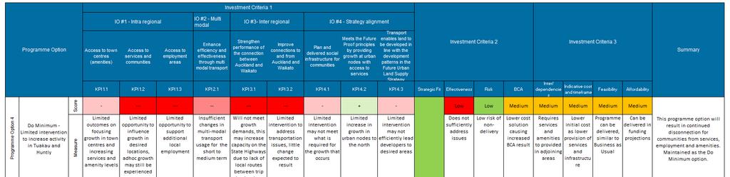
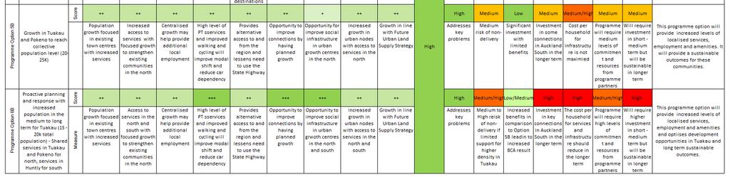
47 Table 10 - Short list programme options assessment summary North Waikato Integrated Growth Management - Programme Business Case 42
48 7. Recommended programme description and assessment 7.1 The recommended programme The recommended programme is Programme Option 6B. This programme focuses on future growth around existing towns of Tuakau, Pokeno, Te Kauwhata and Huntly with high intensity development around Tuakau. This requires proactive planning and response with increased population in the medium to long term for Tuakau with a projection of 15,000-20,000 residents. There will be shared services for Tuakau and Pokeno to cater for the north of North Waikato, and Huntly is to continue to be the primary service town for the southern area within the North Waikato providing some of the essential services for the Te Kauwhata community. This is aimed at increasing the level of self-contained movements within the towns and within the North Waikato. Implementing the recommended programme will consist of planning infrastructure activities in the three waters, land use, public transport, walking and cycling, roading, social, parks and recreation, education, medical and emergency services areas. There will also be planning to be undertaken to zone and enable residential and / or commercial growth to the identified levels in the growth nodes of Huntly, Pokeno, Tuakau, Te Kauwhata and Meremere. Growth in Tuakau will need to be carefully considered and will likely require high levels of urban planning to minimise impact from growth on the surrounding productive land. Collaboration between the programme partners, other infrastructure providers and potentially commercial developers will be crucial to the integrated and successful delivery of infrastructure and services to support the anticipated growth. Enforcing other non-infrastructure activities including more accurate developer contributions, facilitating commercial growth communication with stakeholders and the community on the strategy for the region will also be required. The programme will enable projected population and employment levels as shown in the tables below. These projections are for approximately 50,000 residents within the towns with approximately 17,700 employment opportunities, which reflects the aim to achieve a job per household (approximately 2.5 people per household) in the longer term. The populations for the towns are an upper limit based on the density of development, developable and serviceable land in these towns. The proposed 20,000 residential levels in Tuakau may not be achievable; however, a population between 15,000 and 20,000 for Tuakau with the right level of supporting infrastructure would result in better outcomes for the North Waikato community. Table 11 - North Waikato population projected for recommended programme (Option 6B) Future Proof Settlement Pattern Town Tuakau 4,639 9,402 10,252 22,072 Pokeno 2,132 7,868 12,399 12,762 Meremere* Te Kauwhata (including Lakeside Housing Infrastructure Fund) 1,769 8,991 9,421 10,898 Huntly 7,491 8,764 10,174 10, North Waikato Integrated Growth Management - Programme Business Case


49 * Meremere is not expected to be able to increase its residential population due to unsuitable ground conditions and other land constraints. Table 12 - Current and projected employment projection figures Town Tuakau 1,432 3,761 4,101 8,829 Pokeno 524 3,147 4,960 5,105 Meremere** Te Kauwhata 455 3,596 3,768 4,359 Huntly 2,259 3,506 4,070 4,196 ** Meremere have approximately 70 hectares of land that is zoned for commercial and industrial purposes and could have a significantly higher level of employment than predicted depending on the type of use. Figure 11 below shows the relative levels of growth in population levels and employment over the development periods. Figure 11 - North Waikato Population and Employment levels over the three decade period of the Programme Business Case 44 North Waikato Integrated Growth Management - Programme Business Case
50 7.1.1 Recommended programme elements The following maps set out the recommended programme for the next 30 years. The maps provide an overview of the interventions to be planned, developed and implemented over the next 30 years as the population increases, with more detail available in Appendix E. The recommended programme only includes interventions which are directly attributable or required as a result of growth in the North Waikato. Some of the interventions identified in the recommended programme are interventions outside North Waikato (i.e. park n ride services at Pukekohe) but are important to the long-term development of the area, and need to be considered to promote joined up planning between the North Waikato and Auckland. These Auckland located elements are consistent with the recommended programme in the Transport for Urban Growth Programme Business Case. The following four projects are not contained within the recommended programme as they are not projects directly attributable to the anticipated growth in the North Waikato. However, they are important to acknowledge as they will also support future growth in the North Waikato: NZ Transport Agency - Completion of the Huntly Bypass section of the new Waikato Expressway (in construction) (within 1- years) NZ Transport Agency Development of a Detailed Business Case and pre-implementation works to support the construction of the Bombay Longswamp section of the Waikato Expressway ($2-5M) (within 1-3 years) NZ Transport Agency - Construction of the Bombay Longswamp section of SH1(within 4 10 years) Watercare - Pukekohe wastewater treatment upgrade includes servicing of Te Kauwhata ($120M, recouped through development contributions) (within 1-5 years) 45 North Waikato Integrated Growth Management - Programme Business Case
")


51 Figure 12: Recommended Programme, Short Term (indicatively Years 1 3) The interventions shown in the figure above are those that have generally been planned in recent years to address the growing demand for services and infrastructure in the North Waikato. It should be noted that some of the investments during this period are needed to address current shortfalls in infrastructure and services. 46 North Waikato Integrated Growth Management - Programme Business Case
 The interventions shown above")


52 Figure 13: Recommended Programmes, Short to Medium Term (indicatively Years 4 10) The interventions shown above related to the level of residential growth and employment, the years shown are indicative of the population projections for North Waikato. It should be noted that some of the investments during this period are needed to address current shortfalls in infrastructure and services. Table 13 - Population and Employment at Approximately 2025 Town Population at approximately 2025 Employment at Approximately 2035 Tuakau 9,402 3,761 Pokeno 7,868 3,147 Meremere Te Kauwhata 8,991 3,596 Huntly 8,764 3, North Waikato Integrated Growth Management - Programme Business Case
 The interventions shown above related to the level of")


53 Figure 14: Recommended Programme, Medium Term (Indicatively Years 11 20) The interventions shown above related to the level of residential growth and employment, the years shown are indicative of the population projections for North Waikato. During this period it is expected that Te Kauwhata, Huntly and Pokeno will near their development potential. Whilst population and employment levels will stabilise there will be a need for the development and improvement of services and amenities. Table 14 - Population and Employment for North Waikato in the Medium Term Town Population at approximately 2035 Employment at Approximately 2035 Tuakau 10,252 4,101 Pokeno 12,399 4,960 Meremere Te Kauwhata 9,421 3,768 Huntly 10,174 4, North Waikato Integrated Growth Management - Programme Business Case
 The interventions shown above related to the level of")


54 Figure 15: Recommended Programme, Long Term (Indicatively Years 20-30) The interventions shown above related to the level of residential growth and employment, the years shown are indicative of the population projections for North Waikato. There is expected to be considerable growth during this period in Tuakau as it has good infrastructure and will be able to accommodate the growth within a similar footprint to the current situation. Achieving this increased level of growth may need to be accommodated through increases in density and will be subject to long term community planning. Town Population at approximately 2035 Employment at Approximately 2035 Tuakau 22,072 8,829 Pokeno 12,762 5,105 Meremere Te Kauwhata 10,898 4,359 Huntly 10,490 4, North Waikato Integrated Growth Management - Programme Business Case
55 Recommended programme assessment The recommended programme has a strong alignment with the objectives of the Government Policy Statement on Land Transport and a number of policies for the Waikato region, including the key regional land use planning strategy Future Proof. The recommended programme will provide a wide range of benefits for the current and future communities of the North Waikato including but not limited to: decreasing costs of infrastructure due to densification of development; increased accessibility and connection to communities with a range of services, social infrastructure and amenities; and increased local employment, decreasing the need to leave North Waikato for work. The importance for social infrastructure to be provided proactively with growth, while maintaining the community identity has been received from the local community boards: Onewhero-Tuakau Community Board, Pokeno Community Committee, Te Kauwhata Community Committee. There has been support for the recommended programme to: grow Tuakau to a town of between 15,000-20,000 people acknowledging the importance of the strategic location of Tuakau with regards to Pokeno and Pukekohe in particular; provide an integrated approach of different parties (councils and agencies) working together to ensure integrated land use and infrastructure planning in the North Waikato; have Waikato District Council provide a spatial framework for developers rather than being reactive; protect arable soil around Tuakau and understand that the best way to grow the town is to intensify; ensure that social infrastructure and community services are in line with the development and not after the growth has occurred to ensure that it creates an attractive place to live; provide employment opportunities to ensure that people in North Waikato do not have to travel long distances for employment; provide effective planning for Tuakau which encourages growth and investment; look at upgrading roading connections in particular Pokeno, Whangarata and Buckland Roads; and have better public transport to support existing needs and the future needs. There are concerns in regards to the effect of intensification possibly leading to an unattractive urban environment. Good urban design is required and it has been identified that the District Plan Review is key to this process. There is an opportunity to use this process to hold any plan changes until the review is completed New Zealand Transport Agency Results alignment assessment When evaluating strategies, programmes, packages and projects, the Government Policy Statement (2015) and the Draft Government Policy Statement (2018) both require local government and the New Zealand Transport Agency to consider a number of matters including a rating assessment against the Investment Assessment Framework. To give effect to the draft GPS, a new Investment Assessment Framework has been drafted, which requires rating strategies, programmes, packages, projects and other activities against the results alignment assessment and Cost Benefit Appraisal. Due to the multi-faceted nature of this programme business case a BCR has not been calculated. As part of the LTP processes for council s they will need to prepare relevant assessments. For local roading improvements or public transport investment BCRs and other information will need to be provided to NZTA before funding can be confirmed. The SH1 upgrade between Bombay Hills and Longswamp will have a detailed economic assessment as part of the Detailed Business Case. 50 North Waikato Integrated Growth Management - Programme Business Case
56 Results alignment assessment Results alignment assessment an assessment aimed at strengthening the links to the GPS, providing an increased customer focus as an outcome, providing a focus on integration and providing a new very high rating option for nationally strategic investments, cost-benefit appraisal and programming support to assess the urgency and whether there is a need to prioritise addressing the problem. The Results Alignment assessment is High as the Programme Business Case takes into consideration the improvements to whole of network, long term local, regional and national planning. These are all in response to significant changes in actual and predicted transport demand and their drivers of change in population and employment growth. The recommended programme outcomes include: easing of congestion in future (particularly on State Highway 1 Waikato Expressway and the Auckland Southern Motorway); optimising levels of service, operation and management of transport networks (State Highways, local, public transport but also other infrastructure required to support growth); improvement in journey time reliability, which is likely to worsen as growth occurs; decreasing costs of infrastructure due to densification of development; increased accessibility and connection to communities; increased local employment, decreasing the need to leave north Waikato for work; and a reduction in the number of deaths and serious injuries as transport choices increase, and the transport networks are optimised Cost benefit appraisal No funding from the National Land Transport Fund is sought as a direct result of this Programme Business Case. Waikato Regional Council and Waikato District Council will be seeking funding through their Long Term Plans and the NZ Transport Agency projects specified in the recommended programme have already had their funding approved. As no funding is being sought from the National Land Transport Fund for the recommended programme detailed in this Programme Business Case, the cost-benefit assessment has not been calculated. Where funding is still sought, the cost-benefit assessment will be developed as Waikato District and Regional Council s develop their long term plans. 7.2 Programme Risk As with any investment programme, particularly over a longer time period, there are risks and uncertainties that need to be considered. Some can be reduced during the development of the recommended programme activities, others are inherent, and some will be need to be managed as the programme is implemented. The specific risks identified at this stage are outlined in Table 15 below. Table 15 - Summary of identified key risks Risk Area Description Treatment Strategy Societal Growth of residential development continues in an adhoc way due to private plan changes and approvals provided by programme partners resulting Continued collaboration with programme partners through a range of venues including Future Proof and other forums 51 North Waikato Integrated Growth Management - Programme Business Case
57 Risk Area Description Treatment Strategy Stakeholder Operational Financial Environmental and social responsibility Reputational Cultural Statutory requirements in continued disconnection of communities from essential services The programme requires investment and co-ordination between stakeholders and other partners to deliver the programme efficiently Impacts to utility operations as a result of the upgrades and improvements Costs are difficult to accurately confirm due to the nature of the improvements and the long term nature of the programme The North Waikato has areas of natural and cultural significance and any of the planned work could have an adverse effect on the environment There would be considerable reputational risk to the partners and the impact on the local and regional economies if the infrastructure does not adequately support the increasing population and the traffic demands of the region Programme interventions don t fully consider cultural implications Local Government Act and Resource Management Act requirements Governance structure established which engages with key stakeholders such as Ministry of Education. Communications strategy and plan developed to ensure early engagement and liaison with stakeholders and partners Prepare detailed traffic management plans, water shutdown and contingencies plans for the programmed improvements to minimise impacts to residents and visitors as the infrastructure is developed Undertake enabling activities and Business cases as early as possible following consultation Planning and implementation will need to use high levels of design and construction focus on reducing actual and potential adverse impacts. Early engagement with affected parties is essential. Commence planning for long term outcomes and reduction in risk of failure. Engage early with the affected parties and co-ordinate strongly across the programme partners to reduce risk of inadequate support Clear and open consultation and engagement with local iwi High level land use planning requirements have been built into the Recommended Programme. Statutory processes including consultation should be in line with the Local Government Act and Resource Management Act Part 2 requirements and take place per the requirements of the individual programme interventions 52 North Waikato Integrated Growth Management - Programme Business Case
58 8. Programme financial case 8.1 Indicative cost and programme cash flow The programmes known indicative costs are as follows: Table 16 - Indicative Programme Costs Years 1-3 Years 4-10 Years Years Community $15,100,000 $1,500,000 TBC TBC Parks and Recreation $2,150,000 $100,000 TBC TBC Education TBC TBC TBC TBC 3 Waters $51,435,000 $28,360,000 $3,000,000 $2,000,000 Public Transport 5 $1,000,000 TBC TBC TBC Transport, roading, walking and cycling 19,750,000 37,500,000 30,000,000 47,500,000 (TBC) Medical TBC TBC TBC TBC Emergency Services TBC TBC TBC TBC Land use planning * $2,200,000 $370,000 TBC TBC Community $15,100,000 $1,500,000 TBC TBC * WDC recognise the importance of early and considered timing for planning and is seeking additional funds through the LTP process as well as investigating other funding sources and investment partners Note that the above costs are for implementation of the recommended programme as it currently stands, and where information is available. The costs do not include maintenance and operations which will need to be identified as the individual interventions are developed. 8.2 Funding arrangements The programme is comprised of elements which are the responsibility of either the programme partners or key stakeholders. Waikato District Council has responsibility for the largest number of programme interventions, all of which will have their funding established through the Waikato District Long Term Plan (LTP). A number of local transport and three water interventions relating to Te Kauwhata are anticipated to be funded through the national Housing Infrastructure Fund interest free loan scheme, which will be incorporated into the LTP funding arrangements. The Waikato District Long Term Plan ( ) is currently under development, and anticipated to be open to the public for consultation in March The Plan will allocate funding for the first 10 years of capital expenditure required to achieve their recommended programme interventions. It is anticipated to be adopted by Council by June Indicative figures from NW PT network review 53 North Waikato Integrated Growth Management - Programme Business Case
59 The NZ Transport Agency will contribute funding to the road, walking, cycling and public transport elements of the recommended programme through the National Land Transport Fund (NLTF). The state highway related interventions will be entirely funded by the NLTF, and the rate of funding assistance from the NLTF towards the Waikato District and Waikato Regional Council s transport related programme interventions will be determined through the National Land Transport Programme (NLTP). The NLTP is currently being developed, and will confirm the transport activities in this Programme Business Case which are prioritised for funding between 2018 and 2021 by June The education, medical and emergency service recommended programme interventions will be funded separately by the Ministry of Education, Counties Manukau and Waikato District Health Board and emergency service providers respectively. These stakeholders will confirm the funding arrangements for their infrastructure and service plans as their plans become more defined. Where there is opportunity for collaboration and / or joint services, cost-sharing with other funding partners will be investigated. The funding programmes of all of the partners and stakeholders responsible for the programme implementation will need revision, and cost sharing agreements to be put in place as shared opportunities for service provision emerges and more accurate cost estimates are confirmed through future business cases stages for the different projects. 8.3 Affordability The programme is being scheduled through the Long Term Plans of Waikato District and Regional Councils where possible as this sets out staging and associated funding scheme (including a loan from the HIF) to ensure the affordability of the work of over the next 10 years. Those elements of the work which are to be funded through the NLTF will need to have their affordability coming through the inclusion of the individual components of the programme in the NLTP. Beyond these two funding periods, the affordability of the programme cannot be confirmed at this point. The recommended programme covers a 30 year time period, and the affordability of the different aspects of later components of the recommended programme will need to be developed as part of the future business case and work package development. 54 North Waikato Integrated Growth Management - Programme Business Case
60 Part C Delivering and monitoring the programme 9. Management case The following is a high level outline identifying the short term priorities and progression following the programme Business Case. 9.1 Planning and delivery overview The planning and delivery during the first three years of the programme are set out in the future development of the identified growth areas of the North Waikato the towns of Tuakau, Pokeno, Meremere, Te Kauwhata and Huntly. In particular, masterplans to guide the development of the identified growth and accommodate the recommended programme interventions will need to be established to achieve the integrated delivery of the programme. As such, there is a relatively high planning and land use element of the work in the first three years. Establishing strong co-ordination and engagement between the delivery and programme partners will be critical during this period, as precincts, co-location and partnership opportunities are identified and built into the master planning process. Establishing these relationships and processes to provide a co-ordinated approach to the delivery of the recommended programme will be crucial to supporting growth in the North Waikato over the life of the programme. Noting that the bulk of the recommended programme is the responsibility of the Waikato District Council, it is recommended that Waikato District Council staff take responsibility for co-ordination between the various programmes. The physical infrastructure programme set out for the years will be focused on improving levels of service or addressing service gaps where growth is already occurring. Beyond this point, the recommended programme will need to be flexible and open to review between the programme delivery partners, in response to the levels and patterns of growth. 9.2 Integrated planning with clear roles and responsibilities The delivery of the recommended programme relies on each of the delivery partners taking responsibility for their elements of the programme and working with the other partners and stakeholders to integrate the programme delivery. The delivery partner s high level responsibilities are shown in Table 15. A new working group with representatives from the delivery organisations will be developed under the umbrella organisation of Future Proof. The purpose of the working group will be the promotion of collaboration between projects, both cross-sector and cross boundaries, identifying opportunities for shared engagement on projects, reporting on programme progress and measures and to regularly review the recommended programme content and its timeframes. The group will potentially be responsible for updating the recommended programme to ensure it is directly addressing and planning for the growth needs of the North Waikato. The working group members will report back to the senior management in their respective organisations, identifying where conversations at mayoral, or chief executive level are required to successfully co-ordinate and deliver the programme across the organisations and region. This approach enables the flexible use of 55 North Waikato Integrated Growth Management - Programme Business Case
61 existing communication avenues such as Waikato Mayoral Forum to develop opportunities and reach consensus on how the programme elements can be integrated and managed and delivered as effectively as possible across territorial authority boundaries and organisations. Table 17 - Delivery Organisation Responsibilities Delivery Organisation Waikato District Council Waikato Regional Council Auckland Council Auckland Transport NZ Transport Agency Counties Manukau District Health Board Waikato District Health Board Ministry of Education Emergency service Providers including Fire and Emergency NZ and NZ Police Responsible for Community facilities upgrade and development, local road interventions three waters infrastructure, parks and recreation, walking, cycling and land use planning interventions Public transport (buses and community transport), Land use planning in Auckland Passenger rail services and infrastructure State highway upgrades and development Medical service provision and improvements in Pokeno and Tuakau and further north into the Auckland region Medical service provision and improvements in Meremere, Te Kauwhata and Huntly and further south into the Waikato region Increased capacity and numbers of school facilities Improved and increased fire, ambulance and police services A recommended next step from the Programme Business Case is the development of the working group details including appropriate members and terms of reference. The process through which the working group will address cross-boundary funding of projects should be set down at this point also. 9.3 Programme performance and review Understanding what is being achieved by the Programme Business Case Partners will help to guide the scope of future projects, and identify what is still required and where to support growth in the North Waikato. This section provides an overview of how the delivery of the Programme Business Case could be monitored, how the benefits are measured and by whom. It is likely that further measures beyond those set out below will be agreed, or appropriate proxies will replace some of the recommended measures. Table 18 - Recommended Performance Measures Measure Bus and community travel use from patronage data Journey to work and school distance from Census data Responsibility Waikato Regional Council Waikato District Council 56 North Waikato Integrated Growth Management - Programme Business Case
62 Measure Location, type and rate of growth from resource consent and rates data Liveability perceptions from the Waikato Perception Study Employment statistics from MBIE annual economic activity reports Levels of service and numbers of walking and cycling facilities Number of new community facilities and parks or recreation facilities Number of new primary schools and secondary schools with increased capacity Level of service, capacity and proximity of medical and emergency services available Travel time reliability using most up to data collection sources Average travel time - using most up to data collection sources Number of crashes using CAS data Responsibility Waikato District Council Waikato District Council Waikato District Council Waikato District Council Waikato District Council Waikato District Council Waikato District Council NZ Transport Agency NZ Transport Agency NZ Transport Agency 9.4 Stakeholder engagement and communications plan The first ten years of the programme relating to the Waikato District s responsibilities will be consulted on as part of the consultation strategies associated with the Waikato District Council draft Long Term Plan Process. The Waikato Regional Council s public transport related component of the recommended programme has its own specific consultation plan around it which is currently underway, or will be undertaken as part of their Long Term Plan consultation strategy. These processes will align the organisation s consultation and engagement approaches and meet the RMA Part 2 Requirements. The elements which are the responsibility of the NZ Transport Agency will also have consultation undertaken in a way which aligns with the NZ Transport Agency s consultation and engagement strategies, as well as meeting the RMA Part 2 requirements. The North Waikato Working Group will collaborate to develop visual resources to assist to deliver the key messages of the Programme Business Case. These resources and the collaborative process can be built on to align and deliver the future stakeholder engagement work that will be required for later activities set out in the recommended programme. A number of stakeholders have been outlined below as important to the delivery of the programme. Important stakeholders: Waikato District Council Waikato Regional Council New Zealand Transport Agency Auckland Transport 57 North Waikato Integrated Growth Management - Programme Business Case
63 Hamilton City Council Auckland Council Other key stakeholders: Waikato Tainui Ngā Karu Atua o te Waka Hauraki Iwi (detail to be confirmed as also tangata whenua for the subject area) Ministry of Transport The North Waikato community KiwiRail WaterCare Ministry of Education District Health Boards Emergency services National Road Carriers 9.5 Next steps The following are key areas for further investigation and activities to deliver the programme: Consideration of effects beyond the North Waikato Understanding the impacts of recent growth in North Waikato and future growth across the upper north island of New Zealand is complex. Whilst growth in the North Waikato has the potential to shift growth away from South Auckland and North Hamilton it is difficult to confirm and estimate. Growth in the North Waikato will provide housing for people that may be otherwise not be able to access due to supply pressures and if the growth is well managed there will be local employment opportunities. Any growth across Auckland and the Waikato will result in the need for infrastructure provision across these regions for a variety of areas including schools, social infrastructure and 3 waters. The primary cross boundary effect is for transport infrastructure and services. The growth proposed as part of the recommended programme for North Waikato is only to be promoted if there is a high level of local infrastructure/services and employment provision to offset the transport infrastructure/services provision. Long Term Plans The relevant programme partners are currently developing their Long Term Plans. Projects outlined in the recommended programme are currently being developed or under consultation n with the local communities. Stakeholder and Communication Plan The Programme Business Case has been in partnership by number of stakeholders to gain a greater insight into the problems, constraints, investment needs and drivers, and opportunities for the North Waikato. A Stakeholder and Communications Plan will be developed which aligns with Future Proof, Waikato District Council and the NZ Transport Agency s consultation and engagement strategies, as well as meeting the RMA Part 2 requirements. 58 North Waikato Integrated Growth Management - Programme Business Case
64 The plan will be prepared to address the specific details for each stakeholder, including key contact person and approach for engagement. Working Group The working group details including the appropriate members, and terms of reference will need to be developed. The process through which the Working Group will address cross-boundary funding of projects will be set down at this point also. Indicative / Detailed Business Case SH1 Bombay Hills to Longswamp Involves an upgrade of SH1 through the North Waikato to improve the standard of the highway to a similar level as the new sections of the Waikato Expressway as well as the Southern Motorway improvements that are currently being investigated. Scope to be confirmed by the NZ Transport Agency. Strategic Case Public Transport Connections between Waikato and Auckland The appropriate/ improved public transport connections between North Waikato and Auckland are still to be determined. A strategic case will be most appropriate place to identify this, and the potential approach (i.e. staging of the public transport improvements) that would be most appropriate. 59 North Waikato Integrated Growth Management - Programme Business Case
65 Appendices
66 Appendix A Population projections Where possible, this Programme Business Case has used the population projections forecast by the National Institute of Demographic and Economic Analysis (NIDEA) and Future Proof to inform the content of this document. Below is an extract from the Waikato Plan with information relating to Waikato District Council s predicted growth between 2016 and The population projections are based on Statistics NZ s revised Estimated Usually Resident Populations (EURPs) derived from the 2013 Census data. NIDEA and Future Proof have then applied a combination of age and gender specific assumptions for the three principal demographic drivers (birth, death and migration rates) to the current base population to project future populations. Using these NIDEA / Future Proof projections provides consistency between Future Proof documents and planning and this Programme Business Case.
67 Waikato District Council Growth Period Decade 1: Year Population and Household Demand based on University of Waikato (UoW) Projections Area Number of Households 2016 Household Growth UoW Low UoW Medium Tuakau* Pokeno Te Kauwhata Huntly Ngaruawahia Raglan Urban Total Taupiri Horotiu Gordonton Matangi Tamahere-Tauwhare Whatawhata Te Kowhai Hamilton Urban Area*** within WDC Total Rest of District District Total Area Population 2016 Population Growth UoW Low UoW Medium Tuakau* Pokeno Te Kauwhata Huntly Ngaruawahia Raglan Urban Total Taupiri Horotiu Gordonton Matangi Tamahere-Tauwhare Whatawhata Te Kowhai Hamilton Urban Area*** within WDC Total Household Supply (total capacity of cells) Area Supply Tuakau* Stage Pokeno** Stage Te Kauwhata 2579 Huntly 300 Ngaruawahia Stage Raglan 200 URBAN TOTAL 5644 Taupiri Stage Horotiu Stage Te Kowhai Stage Rest of District Area Supply Deficit or Carry Over UoW Low UoW Medium Tuakau* Stage Pokeno** Stage Te Kauwhata Huntly Ngaruawahia Stage Raglan URBAN TOTAL Taupiri Stage Horotiu Stage Te Kowhai Stage Summary: Most areas have sufficient capacity for the decade in either a UoW Low or Medium growth scenario. In both scenarios, there would be insufficient capacity in Huntly. The insufficient capacity in Raglan will be met by supply in neighbouring CAU Te Uku which is where the Rangitahi Peninsula is located. Strategic Overview and Infrastructure Needs for Growth Areas Tuakau: LTP Funding is committed for stormwater reticulation extensions, wastewater pump station upgrades, wastewater reticulation extensions, water supply reticulation extensions and collector roads as per the Structure plan. Pokeno: LTP Funding is committed for neighbourhood parks, reserves, sports ground and walkway. Stormwater reticulation extensions and upgrades, wastewater pump station upgrades and water supply reservoir extension. Various roading intersection upgrades and Pokeno Bridge. Te Kauwhata: Funding is committed to in the LTP for Roading, 3 waters and Parks as per the Structure Plan. Council has also applied for the Housing Infrastructure Fund to support the additional 1500 households in the proposed Lakeside Development. Huntly: Funding is committed to reservoir extensions. Ngaruawahia: Will be part developer-funded i.e. localised infrastructure. Council is investigating options for improved road connectivity and bulk infrastructure upgrades. Funding is currently committed to water reticulation upgrades. Raglan: Funding has been set aside for collector roads within the Lorenzen Bay area. Rangitahi Peninsula is 100% developer funded. Funding is committed to water supply upgrades and Wainui Road Bridge investigation. Certainty HIGH DEGREE OF CERTAINTY: Growth cells and capacity known. Infrastructure is in place, committed or about to be committed. Greenfield land either zoned (Pokeno Stage 1, Te Kauwhata, Ngaruawahia Stage 1 and Raglan) or growth management plan/plan change underway (e.g. Tuakau, Huntly) for additional zoning. LOW DEGREE OF CERTAINTY: Council will be considering a private plan change for Te Kauwhata (Lakeside development) which would accommodate an additional 1500 households within 10 years this has been included in the supply column in decade one it is anticipated that this would be additional growth to the projection from Auckland. NOTES: Future zoning in the villages within the Hamilton peripheral area will be done through a Structure Plan/Concept Plan (i.e. Te Kowhai). More detailed planning for these will be done at an appropriate time with Hamilton City Council and the NPS on Urban Development Capacity Project.
68 Rest of District District Total Decade 2: Year Area Household Growth UoW Low Tuakau* Pokeno Te Kauwhata Huntly Ngaruawahia Raglan Urban Total Taupiri Horotiu Gordonton Matangi Tamahere-Tauwhare Whatawhata Te Kowhai Hamilton Urban Area*** within WDC Total Rest of District District Total Area UoW Medium Population Growth UoW Low Tuakau* Pokeno Te Kauwhata Huntly Ngaruawahia UoW Medium Area Supply UoW Low UoW Medium Tuakau Stage 1 Carry Over Tuakau* Stage Tuakau Total Pokeno Stage 1 Carry Over Pokeno Stage Pokeno Total Te Kauwhata Carry Over Te Kauwhata Te Kauwhata Total Huntly Carry Over Huntly Huntly Total Ngaruawahia Stage 1 Carry Over Ngaruawahia Stage Ngaruawahia Total Raglan Carry Over Raglan Raglan Total URBAN TOTAL Taupiri Stage 1 Carry Over Taupiri Stage Taupiri Total LESS CERTAIN Demand is less certain. Infrastructure planning is in place for some cells (Te Kauwhata) and not in place for others (Tuakau Stage 2) at this stage but is to be addressed in LTP Cell sequencing and capacity subject to review. New growth cells (i.e. Pokeno Stage 2) informed by a high level concept plan, further work is still to be completed. NOTES: Future zoning in the villages within the Hamilton peripheral area will be done through a Structure Plan/Concept Plan (i.e. Te Kowhai). More detailed planning for these will be done at an appropriate time with Hamilton City Council and the NPS on Urban Development Capacity Project. Raglan Horotiu Stage 1 Carry Over Urban Total Horotiu Stage Taupiri Horotiu Total Horotiu Gordonton Matangi Tamahere-Tauwhare Te Kowhai Stage 1 Carry Over Te Kowhai Stage Te Kowhai Total Whatawhata Te Kowhai Hamilton Urban Area*** within WDC Total Rest of District District Total Area Supply Deficit or Carry Over UoW Low UoW Medium Tuakau Total Pokeno Total Te Kauwhata Total Huntly Total Ngaruawahia Total
69 Raglan Total URBAN TOTAL Taupiri Total Horotiu Total Te Kowhai Total 9-28 Summary: Most areas have sufficient capacity for the decade in either a UoW Low or Medium growth scenario. In both scenarios, there would be insufficient capacity in Tuakau in which case some land in decade three would be brought forward, likewise for Pokeno under the UoW Medium scenario. The insufficient capacity in Raglan will be met by supply in neighbouring CAU Te Uku which is where the Rangitahi Peninsula is located. Decade 3: Year Area Household Growth UoW Low UoW Medium Tuakau* Pokeno Te Kauwhata Huntly Ngaruawahia Raglan Urban Total Taupiri 12 9 Horotiu Gordonton Matangi Tamahere-Tauwhare Whatawhata Te Kowhai Hamilton Urban Area*** within WDC Total Rest of District District Total Area Population Growth UoW Low UoW Medium Tuakau* Pokeno Te Kauwhata Huntly Ngaruawahia Raglan Urban Total Taupiri 13 6 Horotiu Area Supply UoW Low UoW Medium Tuakau Stages 1 & 2 Carry Over Tuakau* Stage Tuakau Total Pokeno Stages 1 & 2 Carry Over Pokeno Stage Pokeno Total Te Kauwhata Carry Over Te Kauwhata Te Kauwhata Total Huntly Carry Over Huntly - - Huntly Total Ngaruawahia Stages 1 & 2 Carry Over Ngaruawahia Stage Ngaruawahia Total Raglan Carry Over Raglan Raglan Total URBAN TOTAL Taupiri Stages 1 & 2 Carry Over Taupiri Stage Taupiri Total Horotiu Stages 1 & 2 Carry UNCERTAIN Demand is less certain. Not all zoning is in place. Infrastructure planning is not yet in place but to be addressed as part of LTP reviews once zoning has been confirmed. Cell sequencing and capacity subject to review. New growth cells (e.g. Pokeno Stage 3) is based on a high-level concept plan. The Northern Waikato Business Case preferred option shows Tuakau reaching a population of 15,000 20,000 people by To reflect the growth an additional 3600 households has been added onto the existing structure plan projections. NOTES: Future zoning in the villages within the Hamilton peripheral area will be done through a Structure Plan/Concept Plan (i.e. Te Kowhai). More detailed planning for these will be done at an appropriate time with Hamilton City Council and the NPS on Urban Development Capacity Project.
70 Gordonton Matangi Tamahere-Tauwhare Whatawhata Te Kowhai Hamilton Urban Area*** within WDC Total Rest of District District Total Over Horotiu Stage Horotiu Total Te Kowhai Stages 1 & 2 Carry Over 9-28 Te Kowhai Stage Te Kowhai Total Area Supply Deficit or Carry Over UoW Low UoW Medium Tuakau Total Pokeno Total Te Kauwhata Total Huntly Total Ngaruawahia Total Raglan Total URBAN TOTAL Taupiri Total Horotiu Total Te Kowhai Total Summary: Most areas have sufficient capacity for the decade in either a UoW Low or Medium growth scenario. In both scenarios, there would be insufficient capacity in Pokeno which would be addressed when a Structure Plan in completed. With regards to Horotiu this Village will be a large industrial hub so careful consideration needs to be taken when deciding where the residential demand is located.
71 Assumptions: Most of the district s growth is Greenfield development with an assumption of 12 household units per hectare. Approximately 80% of growth will be in Pokeno, Tuakau, Te Kauwhata, Huntly, Ngaruawahia, Raglan and the rural villages. Household and Population figures are based on Census Area Units (CAU s). Any residual supply will be carried forward into the next decade. Future zoning in the villages within the Hamilton urban area will be identified as part of a Structure Plan/Concept Plan process in conjunction with the NPS Urban Development Capacity project work. More detailed planning for these will be done at an appropriate time. Council has submitted an application to the Housing Infrastructure Fund to support the Lakeside Development of 1500 additional households in Te Kauwhata. If unsuccessful the timing of the Lakeside development may be delayed. The Northern Waikato Business case has been factored into the supply column for Tuakau in decade three (additional 3600 households) to show councils ambition to grow Tuakau to 15,000-20,000 by Further work is being done to investigate how this may be achieved. The projections for Pokeno, Te Kauwhata and Huntly in the Business case have also been considered and accommodated. * The Tuakau figure is the total of four CAU s Tuakau, Buckland South, Redoubt and Opuawhanga. Majority of the growth in Tuakau falls outside the Tuakau CAU and into the surrounding CAU s. Not all of the growth in these CAU s will form part of Tuakau some of it will be in the rural areas but an assumption could be made that about 80% of those CAU s growth will be urban. ** Pokeno Stage 1 refers to the structure plan made operative in *** Hamilton urban area includes the following CAU s: Gordonton, Te Kowhai, Whatawhata, Horotiu, Tamahere-Tauwhare, Matangi, and Taupiri. Rural only CAU areas defined by STATS NZ have been excluded.
72 Appendix B Summary of public transport bus services available in the North Waikato Waikato Regional Council services (BUSIT) Waikato Regional Council services (BUSIT) include: A fortnightly bus service operates between Hamilton and Pukekohe via Ngaruawahia, Huntly, Te Kauwhata, Meremere, Pokeno and Tuakau; Hamilton to Huntly, with services operating approximately half hourly during the commuter peaks and hourly through the day. This service operates between 6am and 9pm on weekdays and between 8am and 6pm at weekends; and An internal service operates within Huntly twice a day on weekdays. Auckland Transport public transport services Auckland Transport services include: A Papakura to Pukekohe bus service extends through to Tuakau for one morning and one evening service each weekday; and There is one off-peak return trip between Tuakau and Pukekohe each Wednesday and Thursday. The Thursday service extends to Port Waikato.
73 Appendix C - Existing Social Infrastructure in the North Waikato Towns Medical Centres and emergency services Hospital Primary education Secondary education Sports Recreation and Libraries Retirement homes Supermarkets / generalist food stores Public transport Pokeno Tuakau, Pukekohe for family health, after hours medical emergency service and dentists Mercer Volunteer Fire Brigade Auckland Middlemore Pokeno - 1 primary centre Tuakau secondary school Pokeno - sports clubs and recreational venues: there are 12 hectares of dedicated sports parks reserves and wetlands, some of which are still being developed. There are also walkways yet to be developed Tuakau and Pukekohe Pukekohe Nearest supermarket is in Pukekohe Train at Pukekohe Tuakau Tuakau - medical centre and dentist Pukekohe - for family health, after hours medical emergency service Tuakau Volunteer Fire Brigade Auckland Middlemore 40 km Tuakau - 2 primary schools Tuakau secondary school Tuakau - Tuakau Domain and Dr John Lightbody Reserve (soccer, rugby, cricket, swimming(pool at end of life) Tuakau and Pukekohe Tuakau - elderly care and retirement village Pukekohe - retirement village Local Four Square, nearest supermarket is in Pukekohe Train at Pukekohe Tuakau - contracted bus services between Pukekohe and Tuakau (2 trips per day)
74 Meremere Te Kauwhata (14.5km) or Tuakau (20km) - medical centre and healthcare facilities Auckland - Middlemore OR Hamilton - Waikato Hospital Meremere - 1 primary school Tuakau, Te Kauwhata or Huntly for secondary school Meremere - sports clubs and venues with an emphasis on motor sports due to the nearby Hampton Downs Motorsport Park and the Meremere Drag way. Meremere Te Kauwhata or Tuakau - elderly care facilities and rest home Nearest supermarket is in Pukekohe or Huntly Meremere - fortnightly bus service between Hamilton and Tuakau, via Meremere Te Kauwhata Te Kauwhata - medical centre OR Huntly Pukekohe for after-hours emergency service Te Kauwhata Volunteer Fire Brigade Auckland - Middlemore OR Hamilton - Waikato Hospital Te Kauwhata - 1 primary school Te Kauwhata secondary school Te Kauwhata including golf, rugby, netball, squash, cricket, tennis, swimming, bowling, community fitness centre Te Kauwhata Te Kauwhata - retirement village with elderly care Local Four Square, nearest supermarket is in Huntly Te Kauwhata - fortnightly bus service between Hamilton and Tuakau. Huntly Huntly - three medical centres and one dentist Hamilton for after hours emergency services Huntly Volunteer Fire Brigade Hamilton - Waikato hospital Huntly - 7 primary schools Huntly college Huntly - Maori immersion school from primary to end of secondary Huntly - Huntly Domain, Huntly West Sports Complex (Soccer, Rugby, gymnastics, netball, cricket, swimming heated pool, bowling, Huntly Huntly - Elderly care and hospital Local Countdown and Four Square. Huntly - scheduled bus services between Huntly and Hamilton via Ngaruawahia daily (Northern Connector) Huntly internal bus service on weekdays
75 Appendix D - Strategic alignment Strategy Strategy description and the alignment of the Programme Business Case National Government Policy Statement on land transport (GPS) 2015 Draft Government Policy Statements on land transport (2018) The GPS sets out the Government s high-level strategic direction for investment in the land transport network and priorities over the next ten years. The 2015 GPS has three key priorities economic growth and productivity, improving road safety and value for money. These priorities are supported by objectives including matters such as demand, transport choice, resilience, safety, environmental effects, delivery and cost efficiency. The next GPS has been released as a draft and continues on the three priorities of the 2015 GPS - economic growth and productivity, improving road safety and value for money. A further five strategic priorities have been identified including: supporting economic growth in the regions enhancing resilience supporting intermodal connections providing clarity around expectations for the treatment of environmental impacts using technology and innovation to improve benefits and achieve outcomes The development of this Programme Business Case to cater for future urban growth by the integrated planning of transport, land use is well aligned to the three key GPS priorities, as well as giving effect to the five further strategic priorities identified in the Draft GPS National Policy Statement on Urban Development Capacity (NPS-UDC) The NPS-UDC came into effect on the 1 st of December It has different requirements of councils, dependent on the levels of growth anticipated in the district. As Waikato District has been identified as high growth area, it is required to provide between 15-20% more developable land (i.e. land with sufficient infrastructure support) than the projected demand anticipated over the next 30 years. Part of the purpose of this Programme Business Case is to identify the projected demand, provide a high-level plan identifying how the North Waikato s infrastructure requirements can be met to accommodate this growth, which will inform the Waikato District Plan and assist in giving effect to the NPS-UDC. Regional / Sub-regional Future Proof Strategy Auckland Transport Alignment Project (ATAP) The Future Proof Strategy is a sub-regional growth strategy that covers Hamilton City, Waikato and Waipa districts. Its purpose is to provide a comprehensive growth strategy for the sub-region that takes a long tem view of land use and infrastructure. The Strategy has been reviewed by Waikato, Hamilton and Waipa District Councils in conjunction with Waikato Regional Council and the NZ Transport Agency to identify the long-term settlement patterns for these districts (2017). It is expected that this Programme Business Case will be aligned with and inform the final FutureProof settlement patterns. ATAP is a joint project involving Auckland Council, Ministry of Transport, Auckland Transport, the NZ Transport Agency, and other central government agencies. It sets out to provide a direction for the development of Auckland s transport system over the next 30 years. The project acknowledges the importance of the high volume freight transports between Auckland, Hamilton and Tauranga through the North Waikato and the need to accommodate southward growth by the development of an
76 Strategy Strategy description and the alignment of the Programme Business Case integrated transport system, which crosses the regional boundaries. An identified project of interest to the North Waikato is Improved connections to the Waikato Supporting Growth Waikato Regional Policy Statement Waikato Regional Land Transport Plan Waikato Regional Public Transport Plan Waikato Expressway Network Plan District Waikato District Economic Development Roadmap Waikato District Plan Supporting Growth, formerly known as Transport for Urban Growth (TfUG) is a project between Auckland Transport, Auckland Council and the NZ Transport Agency developed to deliver some of the key priorities set out in ATAP. It covers urban growth areas identified by Auckland Council, and targets transport interventions to best accommodate that growth. The project was reported to the Transport Agency Board in October One of the recommendations from this project was a Programme Business Case to support integrated growth and infrastructure planning in North Waikato. This would assist in the co-ordinated management of the two region s growth challenges. The Waikato Regional Policy Statement sets out the Waikato region s key natural and physical resources issues, and how they should be managed and responded to throughout the region. The Waikato Regional Policy Statement promotes a collaborative approach requiring integrated management of natural resources and the built environment, which acknowledges the importance of an agreed settlement pattern and development, which is sustainable, affordable and planned. As such, the Programme Business Case is well aligned with the high-level aims of the Waikato Policy Statement. This Plan sets out the region s intentions for the development of the land transport system over the next 30 years. It identifies transport issues and priorities aligned to those identified in this Programme Business Case including the growth in freight, tourism and people movements and the importance of co-ordinating, managing and planning land use change for efficient and effective transport networks and services. Delivering on this Programme Business Case will contribute to the delivery of the Regional Land Transport Plan s overall aims. The review of the Waikato Regional Public Transport Plan in 2014/15 identified a need to investigate public transport provision in the northern part of the region, and in particular, Tuakau and Pokeno as significant growth is anticipated in these areas over the next years. The Plan also requires that a business case approach is taken, which aligns with the method and public transport review component of this Programme Business Case. This Plan Ties the funding of the Waikato Expressway to land use planning and avoiding ribbon development. Objectives include enhancing inter-regional and national economic growth and productivity, improving journey reliability and safety, focusing freight movements onto State Highway 1, and providing local network operations and opportunities within the major urban areas bypassed by the Waikato Expressway. The Programme Business Case has a number of similar objectives and as part of the assessment undertaken considers how the potential land use patterns will impact or give effect to objectives for the Waikato Expressway. This document sets out the Waikato District Councils goals for economic growth and how the desired outcomes will be achieved. Key goals include increasing Waikato s international connectedness and encouraging economic links with Auckland and the wider region. The Programme Business Case objectives align and will contribute to these goals. The Waikato District Plan is undergoing review. Waikato District Council intends to notify a proposed Waikato District Plan in The district plan review will enable
77 Strategy Strategy description and the alignment of the Programme Business Case future growth through zoning and plan provisions, and will be a mechanism through which the objectives of this Programme Business Case will be delivered. Tuakau Structure Plan The Tuakau Structure Plan was published in 2014 by Waikato District Council to guide development of Tuakau, and has been given effect to the Waikato District. The Plan provides an approach of carefully staged and integrated infrastructure provision to accommodate growth. This approach aligns with the direction of the Programme Business Case, and will continue to be given effect to.
78 Appendix E - Uncertainty log Area of Degree of Impact on Uncertainty uncertainty uncertainty programme Comment Factors affecting demand Population and Economic Growth Ability to predict the growth in population levels or economic activity in the North Waikato and surrounding regions Some uncertainty High Higher growth requires earlier response and lower growth requires slower delivery of infrastructure and services.. Slower population growth may mean some of the programme elements may not be required or will be required later than anticipated Industrial growth Ability to predict the location and scale of industrial growth in the North Waikato and surrounding regions Some uncertainty Medium The location and type of industrial growth is currently unknown. The amount of industrial growth will affect the number of employment opportunities, and will affect what infrastructure provision is required and where Technological advances Enhanced travel information and driverless vehicles and on-line meetings could affect how people travel and their demand for travel High uncertainty Low Technological advances can reduce the need to travel, the way people work and how they meet their needs. These changes may mean that some of the currently required infrastructure changes or is no longer required The rate of any new technology adoption is difficult to estimate Factors affecting supply Rail as a public transport option in the Waikato Rail is one of the options that could be considered to improve transport connections between the Waikato and Auckland over the medium to long-term. High uncertainty Medium The Business Case recommends a strategic case to consider transport connections between the two regions. If rail further south were to be provided, additional funding and infrastructure would be required to support it. Policy The statutory powers of local authorities to promote change Low uncertainty High Land use and other policy changes i.e. district plan rules and infrastructure provision policies are critical to the successful delivery of the programme
79 Area of uncertainty Uncertainty Degree of uncertainty Impact on programme Comment Policy The ability of the different infrastructure providers to coordinate their investment Medium uncertainty Low to medium Some infrastructure or service providers may not have the resources or capacity to integrate their infrastructure provision into the programme set out in this programme Financial Ability to fund maintenance and operations for new infrastructure either major or minor Low uncertainty Negligible Funding for Maintenance and operations is considered to be available and at sufficient levels Ability to fund a major infrastructure project Some uncertainty High Restricts likelihood of major infrastructure interventions or delays implementation timeframe Factors affecting cost Lack of certainty and detail around some elements of the recommended programme Future capital costs Given the relatively high-level nature of the Programme Business Case analysis there is an inherent lack of certainty and detail around particular projects, specific interventions, and their associated costs and benefits. Difficulty of forecasting future capital costs, particularly in the medium to long term. The lack of certainty is appropriate in some respects, as the programme needs to be regularly re-assessed by the partners. The uncertainty can be reduced and eliminated as a result of detailed investigations which will need to be carried out as part of the necessary investigations into elements of the recommended programme as it progresses (i.e. Indicative and Detailed Business Cases). Near certain Medium Once confirmed, the Waikato District and Regional Council s Long Term Plans and the National Land Transport Programme will provide more confidence in investment into all but the education, emergency and medical services and facilities in the short term.
80 Appendix F - Recommended programme Interest area 1-3 years 4-10 years years years Text colour indicates who has primary responsibility for the intervention Blue = Waikato District Council Green = Waikato Regional Council Red = NZ Transport Agency Black = Other Community Provide WDC Te Kauwhata library Provide upgraded WDC Increase WDC facilities customer and library extension ($1.5M) customer services in customer service, halls (libraries, halls, Isite and Waikato District Council customer services) services in Pokeno ($7.5M) Increase capacity at Tuakau library and provide upgraded WDC customer Identify and implement partnership opportunities such as co-location of community facilities together e.g. libraries Tuakau / Pokeno (Northern Facilities Study) Develop and implement partnership opportunities with and library capacity in Tuakau / Pokeno Continue to develop opportunities for community service hubs and co-location services (Northern and halls or sport Ministry of Education with partners such as Facilities Study) facilities together or the e.g. co-location of Ministry of Education ($2.5M) development of sports facilities and and emergency service New isite(s) in community service schools providers (i.e. Pokeno, Rangiriri and / hubs community hubs with or Te Kauwhata (Part police drop in centres of Northern facilities and libraries) study) ($3M) Parks and Identify future park and Review trails Continue to establish or Continue to establish recreation green space infrastructure and expand parks as per the or expand sports and requirements for the strategy to ensure it is Structure Plans to recreation parks in anticipated population adequate for the accommodate the Tuakau as per the growth levels and population s needs and population growth Structure Plan to stages. Align with minimum requirements set out in the Parks Strategy. Identify their potential locations and size to be incorporated considers any tourism opportunities ($50K) Develop aquatic strategy ($50K) Upgrade Tuakau pool. Work with Sport Implement the colocation, co-funding or partnership opportunities with Ministry of Education / Auckland Council and / or other community accommodate the population growth. Continue to use and develop partnerships for efficient or codelivery of community
81 Interest area 1-3 years 4-10 years years years Text colour indicates who has primary responsibility for the intervention Blue = Waikato District Council Green = Waikato Regional Council Red = NZ Transport Agency Black = Other into the town Structure Waikato and Auckland facilities or service services / educational Plans Council to identify providers. facilities Munro Sports Park in whether this is an Pokeno developed. opportunity to provide / ($1.5M) upgrade to a cross- Tuakau Neighbourhood park development ($1.2M) Develop the potential for shared park and recreation facilities with education facilities (MoE) and Auckland Council ($50K) boundary aquatic facility Establish or expand parks as per the Structure Plans lay-out to accommodate the population growth. (developer led) Provide additional 50ha of sports and recreation park in Tuakau (could be a co-location opportunity with the planned expansion of Tuakau School) Identify partnership opportunities such as co-location or staged provision of schools, halls with recreation or sporks facilities Education Planning for increased Increase capacity of Increase number and/or Increase number numbers and capacity Tuakau and Te capacity of primary and/or capacity of of primary schools in Kauwhata Secondary schools in towns as primary schools in areas of growth Schools required towns as required
82 Interest area 1-3 years 4-10 years years years Text colour indicates who has primary responsibility for the intervention Blue = Waikato District Council Green = Waikato Regional Council Red = NZ Transport Agency Black = Other Planning for increased Increase number or Increase capacity of Increase capacity of capacity of secondary capacity of primary secondary schools as secondary schools as schools at existing schools in Tuakau and required required locations Te Kauwhata Continue to use Identify new Establish information Increase number and/or partnerships for existing opportunities or build and growth planning capacity of primary and new opportunities on existing co-located sharing with Ministry of schools in other towns for co-funding and co- services to add Education as required location of services efficiencies of service Identify partnership opportunities especially for Tuakau and Pokeno and Te Kauwhata co-locating with community or sports / recreation facilities Increase capacity of secondary schools in other towns as required Identify partnership opportunities such as co-location or staged provision of schools and sports / recreation such as schools and community or recreation facilities to create activity hubs, or protect land for future education needs provision or create service hubs facilities to accommodate the stages of growth and the community s needs. Medical Counties Manakau Improve existing Higher levels of service Higher levels of service DHB to assess medical services and function existing and function existing feasibility of a secondary hospital to service south Auckland / North Waikato. Likely to be located in either Drury or Pokeno Develop and implement the opportunities for colocation of medical services and other community or retail services and new medical services Continue to work and information share with the DHBs to understand growth impacts ensure and new medical services Continue to build on the relationships with the DHB to develop new opportunities for Waikato DHB to there are sufficient co-location of services / investigate the medical facilities to service hubs / potential for an
83 Interest area 1-3 years 4-10 years years years Text colour indicates who has primary responsibility for the intervention Blue = Waikato District Council Green = Waikato Regional Council Red = NZ Transport Agency Black = Other accident and medical facility to service the area between Huntly and Pokeno Establish information sharing and planning with Counties Manukau and Waikato DHBs to share the North Waikato growth aspirations and tracking to ensure alignment between the DHB service provision and the sub-region s growth Identify partnership opportunities for colocation, or service hubs such as provision of medical, community or retail services together - particularly in Tuakau and Pokeno Work with the DHBs to understand their aspirations for remote management of health through the use of technology and how this will impact the services provided support the increased population Build on the information sharing and relationships with the DHB to develop new opportunities for colocation of services and cross-boundary (with Counties Manakau DHB) sharing of services or service hubs improved efficiency of services etc
84 Interest area 1-3 years 4-10 years years years Text colour indicates who has primary responsibility for the intervention Blue = Waikato District Council Green = Waikato Regional Council Red = NZ Transport Agency Black = Other within the North Waikato Emergency Discussions and Improve existing fire Higher levels of service Higher levels of service services planning with New services and function existing and function existing Zealand Police and other emergency service providers to share Council s growth aspiration in order to ensure appropriate response as far as service provision by the emergency service providers are concerned. Improve existing police services Improve existing ambulance response Work with emergency service providers (both Waikato and Auckland) to identify potential colocation and shared services and creation of community hubs and new fire services Higher levels of service and function existing and new police offices Higher levels of service and function existing and new ambulance response Combined emergency response centre in Tuakau and new fire services Higher levels of service and function existing and new police offices Higher levels of service and function existing and new ambulance response Continue to work with emergency service providers to deliver / Work with the and take advantage of emergency service technology providers to deliver new improvements to / upgrade emergency deliver emergency services as community services, develop hubs / co-located with community hubs, co- Council services, school locate council services, facilities, retail community facilities etc development etc. Water Tuakau Provide Tuakau New reservoir mains upgrades and bulk water main budgeted for 2017/18 ($5.7M) and 2018/19 ($3.3M) Pokeno New reservoir Pokeno Trunk mains and bulk main ($2.3M) Developer led ($600k)
85 Interest area 1-3 years 4-10 years years years Text colour indicates who has primary responsibility for the intervention Blue = Waikato District Council Green = Waikato Regional Council Red = NZ Transport Agency Black = Other Te Kauwhata water Te Kauwhata water treatment plant main upgrades ($2M) upgrade, reservoir/trunk main ($12.3M HIF) Wastewater Pokeno Pump station Tuakau - Interceptor Pokeno Market Rd B upgrade ($1.8M) pump station and rising pump station and rising Contribution to new main upgrade ($2M) main upgrade ($3M) Pump station/rising Te Kauwhata pump main for Whangarata station upgrade (Mahi Industrial zone St) $(460k) (2017/18 but likely to be constructed 2018/19)( $275k) Pokeno contributions will be required to developers for extensions (currently $350k but likely to increase - allow $1M) Te Kauwhata Trunk main to Huntly $12.5M (HIF) Huntly Wastewater treatment plant upgrade construction $15.5M (HIF) Meremere to Tuakau via existing Pokeno Waster water pump station (Option 2), (primarily for consent
86 Interest area 1-3 years 4-10 years years years Text colour indicates who has primary responsibility for the intervention Blue = Waikato District Council Green = Waikato Regional Council Red = NZ Transport Agency Black = Other compliance and overflow reduction purposes) ($1.96M) Stormwater Updated Catchment Implementing Management Catchment Plans/flood modelling Management Plans for all towns ($500 - ($1.9M) 700k) Implementing Catchment Management Plans ($1.5M) Roading Provide upgrades to Upgrade of Waikato Upgrade rail overbridge Tuakau Bridge Indicative as at local infrastructure as District Council section between Pokeno and replacement ($25M) 19/11/2017 required ($2.5M) Harrisville Rd bridges of Buckland Road to a high standard ($7M) Tuakau to HPMV standard ($3M) Provide upgrades to local infrastructure as replacement ($5M) Provide upgrades to Provide new and required ($10M) Geraghtys road bridge local infrastructure as improved connection ($1.5M) required ($5M) from Pokeno to Tuakau Munro Rd and bridge 2 Collector Rds for and Pukekohe ($10M) ($1.5M) Tuakau ($10M) Provide upgrades to Travers Rd and intersection with Wayside ($3.5M) Planning for Pokeno / Whangarata / Bucklands Road upgrade ($0.5M) SH1 improvements to alignment to enabled South collector for a subdivision in Te Kauwhata ($1.5M) Te Kauwhata Rd upgrade ($1.5M Housing Infrastructure Fund) Waerenga village improvements ($0.5M) local infrastructure as required including Pokeno east-west link ($5M) Te Kauwhata Road deviation and rail crossing / grade separated ($4M)
87 Interest area 1-3 years 4-10 years years years Text colour indicates who has primary responsibility for the intervention Blue = Waikato District Council Green = Waikato Regional Council Red = NZ Transport Agency Black = Other increased speed limit to 110kph kph within North Waikato (Cost yet to be determined) Waikato expressway and connections - consider new or upgraded connections Te Kauwhata interchange roundabout ($2.5M) Upgrade Pokeno / Whangarata Rd (between Pokeno and Tuakau) ($10M) to accommodate economic growth or meet required Levels of Service Public transport Provide increased bus Provide increased bus Provide increased bus Provide increased bus services as per North trips as required to trips as required to trips as required Waikato Public service new growth service new growth Transport Review (servicing Huntly, Rangiriri, Te Kauwhata, Mercer, Tuakau and Pokeno) - Pokeno Tuakau areas, and improve connectivity between key settlements within North Waikato Feasibility study into a areas, and improve connectivity between key settlements within North Waikato Feasibility study into a Potential for high frequency electrified service between Tuakau and Auckland region if demand is justified and Pukekohe Public Transport hub Public Transport hub for downstream - Huntly towns for Te Kauwhata Tuakau investments have between Pukekohe occurred - Te Kauwhata towns between Hamilton - Hamilton Huntly Park and Ride in Pokeno with bus trips Pokeno Papakura to Pukekohe/Papakura ($1M) ($10M)
88 Interest area 1-3 years 4-10 years years years Text colour indicates who has primary responsibility for the intervention Blue = Waikato District Council Green = Waikato Regional Council Red = NZ Transport Agency Black = Other Develop community transport within Huntly to Pukekohe area Walking and Plan walking and Upgrade walking and Walking and cycling Provide walking and cycling cycling facilities cycling facilities in connections between cycling facilities as ($0.25M) Tuakau town centre Pokeno and Tuakau required, improve Pokeno walking and and around schools ($0.75M) networks around cycling network ($1M) schools and centres development ($1M) Upgrade walking and ($2.5M) Te Kauwhata walking cycling facilities in and cycling network Huntly town centre and (600K) around schools (to tie in with the timing of the SH1 revocation process) ($1M) Te Kauwhata walking and cycling network ($1.3M) Land use Council lead and co- Plan changes and Information sharing and Planning for key planning ordinated Master resource consents to facilitation for the co- infrastructure and Note: WDC planning (with partners give effect to the 4 location of services, facilities (funded as recognise the and other infrastructure Structure Plans - facilities and staff time or as part of importance of providers) for Tuakau, Council initiated and led infrastructure (between specific infrastructure early and Pokeno, Te Kauwhata ($80,000 per plan emergency service projects). This considered timing and Huntly. This will change and staff time) providers, Auckland includes: for planning and is seeking additional funds through the LTP process as well as investigating identify infrastructure, service and development partnerships and prioritise actions. (minimum of $250,000 plus staff time) Information sharing and facilitation for the colocation of services, facilities and infrastructure (between emergency service Council and Transport, Ministry of Education, Sport Waikato DHBs and Waikato District Council. (staff time) - Identification / designation and protection of strategic corridors, community assets
89 Interest area 1-3 years 4-10 years years years Text colour indicates who has primary responsibility for the intervention Blue = Waikato District Council Green = Waikato Regional Council Red = NZ Transport Agency Black = Other other funding sources and investment partners Development of detailed Structure Plans to give effect to master planning. Requires consideration of development capacity, potential for intensification, residential and commercial zoning demand and requirements. ($ K per town plus staff time) providers, Auckland Council and Transport, Ministry of Education, Sport Waikato DHBs and Waikato District Council. (staff time) Planning for key infrastructure and facilities (funded as part of specific infrastructure projects detailed earlier in the table). This includes: - Precinct or hub Planning for key infrastructure and facilities (funded as staff time or as part of specific infrastructure projects). This includes: - Identification / designation and protection of strategic corridors, community assets including parks and reserves - Any required plan including parks and reserves - Any required plan changes or resource consents - Land purchase - Enabling temporary land uses on key corridors - Monitoring and review Council led plan review and re zoning as Establish and prioritise planning changes or required land release timetable (Staff time) Develop monitoring programme in partnership with Future Proof (Staff time) Planning for key infrastructure and facilities (funded as part of specific infrastructure projects detailed earlier in the table). This includes: - Precinct or hub planning - Identification / - Identification / designation and protection of strategic corridors, community assets including parks and reserves Any required resource consents - purchasing land - Enabling temporary land uses on key corridors - Monitoring and review resource consents - Land purchase - Enabling temporary land uses on key corridors - Monitoring and review Council led district plan review and re zoning (if required to enable growth) Facilitation and consideration of any developer led investment (staff time) Facilitation and consideration of any developer led investment (staff time) designation and protection of
90 Interest area 1-3 years 4-10 years years years Text colour indicates who has primary responsibility for the intervention Blue = Waikato District Council Green = Waikato Regional Council Red = NZ Transport Agency Black = Other strategic corridors, community assets including parks and reserves - Enabling temporary land uses on key corridors Review Waikato District Development Strategy $50K Facilitation of any developer led investment (staff time) Facilitation and consideration of any developer led investment (staff time)
91 Appendix G Transport Assessment
92 North Waikato Integrated Growth Management Programme Business Case Transport Assessment of Short Listed Options October 2017
93 Project: Title: Document Reference: Prepared by: Reviewed by: Revisions: North Waikato Integrated Growth Management Programme Business Case Transport Assessment of Short Listed Options P:\NZTA\138 North Waikato Programme Business Case\4.0 Reporting\R1D nwaikato.doc Michael Jongeneel and Sandy Mills Ian Clark Date Status Reference Approved by Initials 17 May 2017 A R1A Not approved incomplete draft 1 June 2017 B R1B I Clark 16 July 2017 C R1C I Clark 31 October 2017 D R1D I Clark The drawings, information and data recorded in this document (the information) are the property of Flow Transportation Specialists Ltd. This document and the information are solely for the use of the authorised recipient and this document may not be used, copied or reproduced in whole or part for any purpose other than that for which it was supplied by Flow Transportation Specialists Ltd. Flow Transportation Specialists Ltd makes no representation, undertakes no duty and accepts no responsibility to any third party who may use or rely upon this document or the information.
94 North Waikato Integrated Growth Management Programme Business Case Transport Assessment of Short Listed Options i EXECUTIVE SUMMARY Flow Transportation Specialists Ltd have been commissioned by the New Zealand Transport Agency (Transport Agency), to provide transport planning inputs to the Programme Business Case (PBC) being developed for the North Waikato area. This report is intended to be read in conjunction with the North Waikato Integrated Growth Management PBC. The Programme Options The programme options included a range of infrastructure and non-infrastructure alternatives. Programmes with short, medium and long-term delivery timeframes were considered. The alternatives considered social infrastructure, parks and recreation, education, medical, emergency service, water, wastewater, roading, public transport, walking and cycling and land use, as well as any other investment with positive outcomes for the community and programme partners. The alternatives range from continuing the current approach of dispersed development, with a reactive approach, to more proactive planning with focussing growth around existing settlements. The short listed programmes are outlined below. Programme Option 4 Limited intervention to increase activity in Tuakau and Huntly. This was short listed as the Do Minimum option, as it was agreed by project team members and stakeholders that the current planning (Programme 1A) is not acceptable and will require an increased level of intervention by partner organisations to cater for growth in North Waikato. The evidence confirms that the North Waikato needs to be more connected within towns, within North Waikato and between Auckland. Programme Option 5B Proactive planning, services and amenities for Tuakau and Pokeno (northern), and Huntly (southern). This programme was shortlisted and is recommended for consideration due to high level of services provision, localised employment opportunities and amenities that can be provided. This programme is the same as Programme 6B (see below) but with a lower population level in Tuakau, at approximately 11,000. Programme Option 6B Proactive planning, services and amenities for Tuakau and Pokeno (northern), and Huntly (southern) with growth in Tuakau to reach a larger population level (15,000-20,000, depending on feasibility and intensification of land use) with a redeveloped structure plan and/or planning changes (i.e. to reduce land use and footprint size and services for the northern area shared between Tuakau and Pokeno). This programme was short-listed and is recommended for consideration due to high level of services provision, localised employment opportunities and amenities that can be provided due to critical mass from population levels and employment. It was also supported due to the lower unit cost for developing additional housing in Tuakau for water and wastewater, its ability for increased employment opportunities, existing social infrastructure such as schools and access to potential for long term development of a passenger rail service to Auckland due to the larger, more focused population growth.
95 North Waikato Integrated Growth Management Programme Business Case Transport Assessment of Short Listed Options ii All of the shortlisted programme options include non-infrastructure activities such as developer contributions and future planning with social service providers. The difference in the programmes is the level of investment, where it will be invested and when. The assumed population and employment totals for the three Programmes are set out in Table ES1. (It should be noted that there is a level of uncertainty around these forecasts). Table ES1: Existing and Forecast Land Use assumptions for the Short Listed Programmes Population Employment Programme 4 18,600 24,650 33,500 38,475 6,700 7,575 9,300 11,400 Programme 5B 18,600 26,000 35,100 41,150 6,700 9,200 11,600 15,250 Programme 6B 18,600 27,625 41,750 51,700 6,700 10,275 15,350 19,750 The overall employment to population ratio under Programme 4 is anticipated to reduce from the existing figure of 0.36, to 0.30 in Programme 5B includes an overall increase in population (between Programmes 4 and 5B) of about 2,700 people. However, greater local employment is proposed, in all centres, with Programme 5B, with the overall employment to population ratio anticipated to remain constant from the existing figure of 0.36, to 0.37 in Programme 6B includes an overall increase in population (between Programmes 5B and 6B) of about 10,500 people, with greater population and local employment primarily in Tuakau. The overall employment to population ratio under Programme 6B is anticipated to increase slightly from the existing figure of 0.36, to 0.38 in Transport Assessment This report summarises the existing transport environment, plus the future likely transport environment, taking into account future committed transport projects, and projects that are currently identified but not yet committed, including road and public transport projects identified for South Auckland (see below). The report then identifies a range of issues that will affect consideration of possible additional investment in transport in North Waikato. The Future Do Minimum Scenario This report has noted the transport investment that is currently taking place, or is committed within the North Waikato: In terms of roading, the committed improvements relate primarily to the completion of the Waikato Expressway, between Auckland and Hamilton In terms of public transport, this report has identified the draft North Waikato Public Transport Review. That review identifies the short term public transport interventions within North Waikato to support the delivery of this Programme Business Case, and it is to be expected that this investment (or investment to a similar level) takes place within the Do Minimum scenario.
96 North Waikato Integrated Growth Management Programme Business Case Transport Assessment of Short Listed Options iii This report has also noted the significant work that has been carried out by the Transport for Future Urban Growth project, now known as the Supporting Growth project. This relates to the Auckland region, but there are several as yet uncommitted projects (meaning that they do not yet form part of the Future Do Minimum scenario) which will affect South Auckland as far south as Pukekohe. A particular uncertainty at the current time relates to the future for passenger rail, south of Pukekohe. Until now this has been assumed to be a long term project, but the new Labour led coalition is known to be interested in investing in a rapid rail network linking Auckland, Hamilton and Tauranga. Travel patterns will change in response to land use changes and investment in transport. Locally, Pukekohe is expected to become a more significant destination, while the significant development within South Auckland, and the expected improvements of rail as far south as Pukekohe, are likely to increase trips to/from the north. Land use change in Hamilton will also affect the future distribution, particularly for the southern half of the North Waikato area. Assessment It is noted that the demand for travel should not be assumed to be static, but it will be affected by, for example, the land use mix, and by investment (of for example in travel planning and in high speed broadband) which will reduce the need to travel. It is to be expected that greater proportions of trips will stay within the North Waikato area in the future, as the range of local opportunities increases. The report has included a manual assessment of the effects of the three shortlisted programmes on daily traffic flows (i.e. these estimates have not been informed by separate transport model runs of the three programmes). These estimates assume that the effects of increasing population will be offset by significant increases in local services and amenities (as reflected in the ratios of employment to population, noted above). As a result, Programme 5B is predicted to lead to slightly lower daily traffic flows than Programme 4, due to more people expected to make shorter trips (ie travelling within towns, with less people travelling between towns). However, Programme 6B is predicted to lead to slightly higher traffic flows (than Programme 4), due to the higher population, particularly within Tuakau, but also within Huntly. It is too early to say with certainty that particular transport projects (identified within Section 6 of this report) may be required for one Programme and not another. That said, it is clearly likely that Programme 6B, which include the greatest land use within North Waikato, particularly around Tuakau, is likely to lead to a greater demand for transport investment in some form. This report indicates that the following transport projects are likely to be required: Improvements to public transport will be essential, in order to improve accessibility. As noted above, the draft North Waikato Public Transport Review identifies some short term public transport interventions within North Waikato. Further improvements will also be required in due course, primarily to improve public transport accessibility between North Waikato and the Auckland region, including Pukekohe in particular It would appear that a bus based public transport system would be adequate to serve North Waikato. Any extension of passenger rail, south of Pukekohe, is likely to depend firstly on investment in rail further to the north, within the Auckland region, and secondly on the wider
97 North Waikato Integrated Growth Management Programme Business Case Transport Assessment of Short Listed Options iv assessment of the potential costs and benefits of passenger rail between Auckland, Hamilton and Tauranga. However, the higher population anticipated at Tuakau, with Programme 6B, may assist the justification of rail south from Pukekohe to Tuakau Improvements to the road network between Tuakau and both Pukekohe and Pokeno are likely to be required in order to improve the accessibility and safety of trips to/from Tuakau. Under Programmes 4 and 5B, it appears that a two lane road should be sufficient for Buckland Road (between Tuakau and Pukekohe), but four laning, possibly with public transport priority, is more likely to be required with Programme 6B Improvements to Mill Road (between Pukekohe and would also appear to be required, with all Programmes, between Pukekohe and the SH1 Bombay Interchange. This will be required, to a significant degree, due to the expected growth in Pukekohe, but the need will be increased by the proposed development around and Tuakau, with Programme 6B Improvements to the capacity of the SH1 Pokeno interchanges will be required, with all Programmes The need for the above roading projects may be superceded if the concept shown in Figure ES1 overleaf, or similar, is progressed. This link would extend from SH1, south of Pokeno, to connect into the proposed Pukekohe Expressway (if that concept is progressed), with local connections to Pokeno and Tuakau. Such a link would reduce traffic flows on SH1 between south of Pokeno and the Bombay interchange, and also along Mill Road and Buckland Road. In addition to the road accessibility benefits it would provide connections to the improved rail services as these extend progressively south from Papakura to Pukekohe. Such a concept would be more likely to be justifiable with the greater levels of population anticipated around Pokeno and Tuakau with Programme 6B This report has noted that parts of the North Waikato rely, to a significant degree, on State Highway 1, and the development of a secondary road network between Pokeno and Huntly would appear to be very desirable, in order to remove local trips (including walking and cycling trips) from the Expressway. In particular, a local connection between Te Kauwhata and Huntly would appear to be worth considering, with all Programmes.
98 North Waikato Integrated Growth Management Programme Business Case Transport Assessment of Short Listed Options v Figure ES1: Possible new Roading Connection from SH1 south of Pokeno (shown indicatively in blue) to Future Pukekohe Expressway (shown indicatively in red) 1 1 The dotted red and blue lines in Figure 9 should be taken as very indicative. Clearly, if either or both concepts are progressed, they would need to take into account, and minimise the effects on a wide range of potential environmental, physical and land use (etc) factors
99 North Waikato Integrated Growth Management Programme Business Case Transport Assessment of Short Listed Options vi The likely need for these projects, with each of the short listed Programmes, is summarised in Table ES2. Table ES2: Transport Investment required for Short Listed Programmes Programme 4 Programme 5B Programme 6B Improved Public Transport 2 Required Required Required Additional public transport improvements 3 Required, due to relative lack of local services/employment Further improvements probably required, but less so than with Programme 4, due to greater local services and employment with Programme 5B As Programme 5B, but additional investment likely to be required to serve additional population in Tuakau in particular Passenger Rail Services south of Pukekohe Possible, but the justification and timing will primarily depend on wider considerations to north and south Possible, but the justification and timing will primarily depend on wider considerations to north and south More probable, for the section between Pukekohe and Tuakau. However, the justification and timing will still primarily depend on wider considerations Improved roading connection between Tuakau and Pokeno Improved roading connection between Tuakau and Pukekohe Improvements to Mill Road (Pukekohe to Bombay) Improvements to SH1 Pokeno Interchange New road link between SH1 (south of Pokeno) and proposed Pukekohe Expressway Required, due to likely need for trips to travel between Tuakau and Pokeno Required, due to likely need for trips to travel between Tuakau and Pukekohe Required primarily due to growth in Pukekohe Desirable (but with greater proportions of trips expected to be within Tuakau and Pokeno) Desirable (but with greater proportions of trips expected to be within Tuakau and Pukekohe) Required primarily due to growth in Pukekohe Required Required Required Required, due to greater people living and working at Tuakau Required, due to greater people living and working at Tuakau Required due to growth in Tuakau as well as Pukekohe Less likely to be justified Less likely to be justified More likely to be justified, and it will reduce the need for the above four roading projects 2 As currently envisaged in draft North Waikato Public Transport Review 3 For example, to provide bus connections to rail services to the north
100 North Waikato Integrated Growth Management Programme Business Case Transport Assessment of Short Listed Options vii Table ES2: Transport Investment required for Short Listed Programmes Programme 4 Programme 5B Programme 6B Provision of secondary road network between Pokeno and Huntly Required Required Required Improved walking/cycling connections within towns Required Greater connections likely to be required Greater connections likely to be required, particularly within Tuakau Improved walking/cycling connections between towns Greater connections likely to be required Required Required, especially between Tuakau and both Pokeno and Pukekohe The high level evaluation of the transport effects of the short listed land use programmes is summarised in Table ES3. Table ES3: Transport Evaluation of Short Listed Programmes Programme 4 (P4) Programme 5B (P5B) Programme 6B (P6B) Journey distance to work Poor (i.e. a high proportion of long distance trips) Better than P4 Better than P5B Trips by other Modes Poor (i.e. predominantly car based trips) Better than P4 Better than P5B Travel time (reliability) Base for comparison Similar to P4 Similar to P4, assuming transport investment Travel time delay Base for comparison Similar to P4 Similar to P4, assuming transport investment Deaths and serious injuries Crashes/vehicle kilometres travelled Base for comparison Similar to P4 Better than P4 and P5B, assuming transport investment Base for comparison Similar to P4 Better than P4 and P5B, assuming transport investment
101 North Waikato Integrated Growth Management Programme Business Case Transport Assessment of Short Listed Options viii CONTENTS 1 INTRODUCTION TRANSPORT MODELLING EXISTING SITUATION Existing Transport Networks Existing Traffic Flows Freight Public Transport Crash Analysis Local Road Crashes SH1 Crashes Existing Travel Patterns North Waikato Travel Survey Modelled Travel Patterns Comparison Community Attitudes to Existing Travel Issues LAND USE FORECASTS Previous Land Use Forecasts The Short Listed Programmes Programme Programme 5B Programme 6B TRANSPORT NETWORK CHANGES Improvements to State Highway 1: Southern Motorway Improvements to State Highway 1: Waikato Expressway Transport for Future Urban Growth Public Transport CONSIDERATIONS FOR TRANSPORT INVESTMENT IN NORTH WAIKATO Public Transport Roading Walking and Cycling FUTURE TRANSPORT CONDITIONS Modelled Traffic Forecasts Manually Derived Traffic Forecasts Freight Public Transport ASSESSMENT OF PROGRAMMES Key Performance Measures Effects beyond North Waikato Transport Investment Benefit 1: Improve North Waikato s Liveability... 42
102 North Waikato Integrated Growth Management Programme Business Case Transport Assessment of Short Listed Options ix KPI 1.1 Increased access and proximity to services and amenities, employment areas, town centres and public transport network Benefit 2: Improved Network Performance KPI 2.1: Increased Effectiveness of the transport network to, from and within the greenfield growth areas, for all modes KPI 2.2: Increased Efficiency of the transport network to and within the greenfield growth areas, for all modes KPI 2.3: Reduction in Accidents Summary of Option Assessment APPENDICES APPENDIX A APPENDIX B CRASH ANALYSIS DERIVATION OF FORECAST TRAFFIC FLOW ESTIMATES
103 North Waikato Integrated Growth Management Programme Business Case Transport Assessment of Short Listed Options 10 1 INTRODUCTION Flow Transportation Specialists Ltd have been commissioned by the New Zealand Transport Agency (Transport Agency), to provide transport planning inputs to the Programme Business Case (PBC) being developed for the North Waikato area. This report is intended to be read in conjunction with the North Waikato Integrated Growth Management PBC, and the investment objectives set out in the PBC are as follows: Improve North Waikato s liveability through increased access to, from and within urban growth areas, including to services and amenities, employment areas, town centres Enhance Waikato s connectivity through increased effectiveness and efficiency of the multi modal transport network to, from and within urban areas Improved national and regional economic growth and performance of the Auckland and Waikato regions by improving interregional connections and connections within the Waikato region Deliver on the Future Proof principles and provide infrastructure as required for the North Waikato region and are consistent with development patterns set by Future Proof. 2 TRANSPORT MODELLING This assessment has made use of two regional transport models: the Auckland Regional Transport (ART) model and the Waikato Regional Transport Model (WRTM). However, the study area is located on the edge of both of these models (particularly the ART model), and neither of them include the land uses now anticipated for the North Waikato area. Therefore, while limited information has been taken from both models, the assessment later in the report is primarily based on professional judgement and by analysis of existing and expected trip making, rather than modelling analysis. 3 EXISTING SITUATION 3.1 Existing Transport Networks Figure 1 overleaf shows the existing transport network within the study area, including State Highways 1 and 2 (SH1 and SH2) and key local roads. It also shows the North Island Main Trunk (NIMT) rail line. This Figure highlights that the road network between Pokeno and Huntly is very sparse, and the area relies to a significant extent on State Highway 1, with little secondary road network.

104 North Waikato Integrated Growth Management Programme Business Case Transport Assessment of Short Listed Options 11 Figure 1: Existing Road and Rail Network (image courtesy Google Maps)
105 North Waikato Integrated Growth Management Programme Business Case Transport Assessment of Short Listed Options Existing Traffic Flows Traffic flow data for each of the count locations shown starred in Figure 1 is shown in Table 1 below. Both current and recent historic count data is shown, to illustrate the level of growth that these roads have experienced in recent years. State Highway data has been obtained from the Transport Agency s State Highway AADT Data Booklet for and the TMS website. Data for Mill Road has been taken from Auckland Transport s tube count database, and information for other sites has been taken from Waikato District Council s traffic count database. Table 1: Existing Daily Traffic Flows and Growth Road Section Annual Average Daily Traffic (AADT) Annual Growth Heavy Vehicles SH1 North of Razorback Road 34,200 40,400 +5% 11% SH1 SH2 to Pokeno 21,400 25,200 +4% n/a SH1 Pokeno to Mercer 20,900 24,200 +3% 13% SH1 Mercer to Meremere 18,600 22,600 +4% 12% SH1 Ohinewai to Huntly 18,300 21,700 +4% 12% SH2 Mangatawhiri 13,300 15,600 +4% 12% Buckland Road North of Geraghtys Road 6,330 (in 2008) 6,690 (in 2016) +1% 7% Whangarata Road East of Bollard Road 3,240 3,610 +3% 12% Harrisville Road North of Logan Road 3,510 3,960 (in 2016) +3% 12% Mill Road East of Harrisville Road 13,100 15,600 (in 2016) +4% 11% It is noted that the rate of growth on SH1 in particular has been quite high in recent years, at up to 5% per year (over the five year period), with the highest growth rate being on SH1 north of Pokeno. In fact a higher growth rate occurred between 2014 and 2015, and a rate of around 10% was observed, again on SH1, north of Pokeno. In terms of traffic conditions, the above flows do not indicate any current, significant capacity issues within the North Waikato area itself 4. The maximum observed flow of around 40,000 vehicles/day, two way, on SH1 is comfortably within the capacity of a four lane road, while the maximum flow of over 15,000 vehicles/day on the local roads is also within the capacity of a two lane road. However, it is apparent that conditions deteriorate as one heads north, into South Auckland, with congestion occurring regularly on Auckland s Southern Motorway, from south of Drury. Table 2 overleaf presents directional, peak hour traffic flows for the same locations as above, where available. 4 The potential for future issues is assessed within Section 7 below
106 North Waikato Integrated Growth Management Programme Business Case Transport Assessment of Short Listed Options 13 Table 2: Existing Peak Hour Traffic Flows Road Section Morning Peak Evening Peak Northbound Southbound Northbound Southbound SH1 North of Razorback Road 2,150 1,270 1,880 2,170 SH1 SH2 to Pokeno 1, ,070 SH1 Pokeno to Mercer no hourly data available SH1 Mercer to Meremere no hourly data available SH1 Ohinewai to Huntly Buckland Road North of Geraghtys Road Harrisville Road North of Logan Road Eastbound Westbound Eastbound Westbound SH2 Mangatawhiri Whangarata Road East of Bollard Road Mill Road East of Harrisville Road Where directional, hourly traffic data is available, traffic flows are relatively balanced, with the following tidal peaks noted: At the northern edge of the study area, the highest flows on SH1 are northbound (toward Auckland) in the morning peak, with similar flows southbound in the evening peak Further south on SH1, between Ohinewai to Huntly, the morning peak flows are quite balanced, with the highest flows on this section being southbound in the evening peak Similarly on SH2 at Mangatawhiri, the morning peak flows are quite balanced, with the highest flows being eastbound in the evening peak There are higher eastbound flows on Mill Road, in both the morning and evening peaks. 3.3 Freight Table 1 within Section 3.2 above highlighted the high volumes of heavy vehicles on the main roads in the North Waikato, including over 10% on SH1. It is understood that the majority of these trucks are travelling between either the Waikato or Bay of Plenty regions and the Auckland region. 3.4 Public Transport Within the North Waikato, the Waikato Regional Council operates the following bus services: Hamilton to Huntly, with services operating approximately half hourly during the commuter peaks and hourly through the day. This service operates between 6am and 9pm on weekdays and between 8am and 6pm at weekends
107 North Waikato Integrated Growth Management Programme Business Case Transport Assessment of Short Listed Options 14 A service from Hamilton to Pukekohe via Huntly, Te Kauwhata and Meremere, operating once every two weeks An internal service operates within Huntly twice a day on weekdays. In addition, Auckland Transport operates the following public transport services between Auckland and the North Waikato: The 398 service between Pukekohe and Tuakau. A daily service, primarily for commuters, operates from Tuakau in the morning and returning from Pukekohe in the evening. In addition, an inter peak service operates four times on Wednesdays, for shopping and other trips The 399 service between Pukekohe and Port Waikato, via Tuakau, operating twice daily on Thursdays only. From Pukekohe, rail shuttle services connect to onward services at Papakura. The rail shuttles currently operate three times per hour during the commuter peaks, and hourly through the day. There are no existing passenger rail services south from Pukekohe, apart from the Overlander between Auckland and Wellington, which runs one train every second day (i.e. a northbound train one day, and a southbound train the next). In other words, the existing bus and rail timetables provide a very limited number of services within North Waikato, including between Tuakau and Pukekohe, Huntly and Hamilton and Pukekohe and Auckland (as summarised in Figure 2 below). Connectivity between other North Waikato towns is very limited. Figure 2: Existing North Waikato Bus Services 3.5 Crash Analysis Local Road Crashes A review of the crashes on main local roads (i.e. not State Highways) within the study area has been carried out, for the five year period between 2012 to 2016 inclusive.

108 North Waikato Integrated Growth Management Programme Business Case Transport Assessment of Short Listed Options 15 The analysis indicates a cluster of crashes within the Auckland region section of Buckland Road and Manukau Road and at, and in close proximity to, the intersection of Mill Road and Harrisville Road. Furthermore, a relatively high number of crashes involving pedestrians crossing Manukau Road is highlighted as a possible issue of concern, within the southern part of the Pukekohe township. A map illustrating the indicative local of minor, serious and fatal crashes within the study area (excluding SH1) is provided in Figure 3 below. It is noted that the location of crashes on this map is provided as indicative only to illustrate potential areas with higher crash rates/risk. Further details, including commentary on the main contributory factors, are provided at Appendix A. Figure 3: Indicative location of injury and fatal crashes in study area SH1 Crashes In addition to the local road network crash analysis, a review of fatal and serious crashes on SH1 between Mill Road and Hampton Downs has been undertaken from 2012 to 2016 inclusive. (It is noted that there may be limited value in assessing the crash records along SH1 between Hampton Downs and Huntly, due to the significant road works that have been taking place over that period). Three crashes resulting in fatalities and eight crashes resulting in serious injury have occurred on SH1 within the area selected. One fatal crash involved a pedestrian attempting to cross SH1; the pedestrian may have been alcohol impaired. Another pedestrian crash involved a 16-year old pedestrian and resulted in a serious injury. Two other fatalities occurred within the area selected. One involved a vehicle crashing into a broken down truck and the other involved loss of control due to a suspected sudden illness.
109 North Waikato Integrated Growth Management Programme Business Case Transport Assessment of Short Listed Options 16 While the crash factors for these 11 fatal and serious injury crashes are varied, and there are no locations that have resulted in more than one serious or fatal crash, two crashes involving pedestrians crossing SH1 may indicate an issue of minimal opportunities for pedestrians to safely cross SH1 in the area. 3.6 Existing Travel Patterns North Waikato Travel Survey The following section summarises the results of the North Waikato Household Travel Survey 5, which was carried out in June and July In interpreting the results of the survey, it is important to note that the survey was carried out on a small sample of North Waikato households (256, including 75 in Tuakau, 74 in Te Kauwhata and 46 in Pokeno), and that survey respondents were self-selecting. Figure 4 overleaf illustrates the trip origins and destinations for trips to and from North Waikato households. This figure shows the very strong north-south travel patterns that follow State Highway 1, among survey respondents. Table 3 goes on to present the trip destinations from North Waikato households, by trip types. It can be seen that there is a very strong relationship between North Waikato households and jobs within the Auckland region, with 70% of work trips to the Auckland region among survey respondents. Other trip types, particularly education and medical trips, are distributed more to the local centres. 5 Waikato District Council and Waikato Regional Council (August 2016), North Waikato Household Transport Survey Report Draft

110 North Waikato Integrated Growth Management Programme Business Case Transport Assessment of Short Listed Options 17 Figure 4: Origins and Destinations for Trips, North Waikato Household Transport Survey

111 North Waikato Integrated Growth Management Programme Business Case Transport Assessment of Short Listed Options 18 Table 3: Trip Destinations by Trip Type, North Waikato Household Transport Survey Trip Type Auckland Pukekohe Hamilton Other Destinations Work 70% No data 10% Education 37% No data 12% 14% Tuakau, 14% Onewhero Shopping 24% 42% 12% Medical 37% 32% 14% Leisure 28% 36% 11% 12% Tuakau Other 19% 28% 13% 14% Mercer All Trips 47% 16% 11% Modelled Travel Patterns The following table presents a summary of trip origins and destinations from the 2013 morning peak WRTM, for trips to and from Pokeno and Tuakau. This 2013 model was based (in part) on Household Interview Surveys that were carried out in 2008, although the WRTM did not extend to the former Franklin area at that time so the interview surveys also did not cover that area. Trip origins and destinations have been grouped together into sub-regional areas. Table 4: Pokeno and Tuakau Trip Origins and Destinations, 2013 Morning Peak Period, WRTM Trips to/from Pokeno Tuakau Pokeno 4% 4% Tuakau 8% 12% Pukekohe 18% 30% North 6% 6% Auckland 17% 11% East 6% 3% South 12% 11% Sth of Huntly 2% 1% West 27% 22% Comparison The above outputs from the North Waikato Household Travel Survey results are somewhat contradictory to the WRTM, in that:
112 North Waikato Integrated Growth Management Programme Business Case Transport Assessment of Short Listed Options 19 The WRTM suggests that 11% of Tuakau and 17% of Pokeno morning period trips in 2013 were to Auckland, with a surprisingly high proportion heading to the west The household travel survey suggests that 47% of daily trips from North Waikato households are to Auckland in 2016 (and presumably even higher from Tuakau and Pokeno). It may be that some of the above discrepancy is due to sampling bias within the newer North Waikato survey, or that Auckland is now attracting a greater proportion of North Waikato trips than in 2008 (the date of the Household Interview Survey which informed the development of the WRTM), due to the strength of the Auckland economy. However, North Waikato area is right on the edge of the WRTM and as noted above, the HIS did not include the former Franklin area at the time the model was originally developed. This suggests that there may be a local trip distribution issue to be resolved, within the WRTM, which may need to be addressed for any detailed tests which use the WRTM for projects in this area. It should also be noted that the above figures relate to the modelled distribution of existing trips. These patterns will change in response to land use changes within and beyond North Waikato. In particular, it is to be expected that greater proportions of trips will stay within the North Waikato area, as the range of local opportunities increase. On the other hand, the distribution of longer distance trips will change in response to land use changes and investment in transport. Locally, Pukekohe is expected to become a more significant destination, while the significant development within South Auckland, and the expected improvements to passenger rail as far south as Pukekohe, are likely to increase trips to/from the north. Land use changes in Hamilton will also affect the future distribution, particularly for the southern half of the North Waikato area. 3.7 Community Attitudes to Existing Travel Issues Waikato Regional Council (and others) are considering improvements to public transport in the North Waikato area, and as noted in Section 3.6 above, household travel surveys were undertaken in July The main feedback from the community to the surveys was as follows: There is a lack of public transport in the North Waikato area. This was identified by 42% of respondents as being the main transport challenge for their household People in these communities have limited transport choices. 10% of respondents had limited or no access to private cars, due to disabilities or age There is a willingness to use public transport if available. 63% of respondents stated they were likely to use public transport for shopping or leisure purposes, 55% for health services and 48% for work related trips, if public transport was available There is a strong community interest in passenger rail. Rail related issues were identified by 24% of respondents. 58% of persons responding from Pokeno indicated that they would use a bus for travel to Auckland, if it was available Traffic congestion was named as the main transport challenge by 13% of respondents.
113 North Waikato Integrated Growth Management Programme Business Case Transport Assessment of Short Listed Options 20 4 LAND USE FORECASTS 4.1 Previous Land Use Forecasts This section presents land use forecasts included within the ART model and the WRTM. It should be noted that: The ART model does not extend further south than Pokeno/Tuakau WRTM is in the process of being updated from a 2006 base year to a 2013 base year. The land use forecasts for 2041 relate to the earlier, 2006 model version The figures in Table 5 are in household numbers, not population numbers. Table 5: Existing and Forecast Households, ART Model and WRTM ART WRTM ART WRTM 6 ART WRTM Tuakau 7 1,575 1,435 1,900 1,700 2,550 2,820 Pokeno ,150 1,475 Meremere Te Kauwhata ,675 Rangiriri Huntly 2,375 2,450 3,350 Table 6: Existing and Forecast Employment, ART Model and WRTM ART WRTM ART WRTM ART WRTM Tuakau ,210 1, ,650 1,950 Pokeno Meremere Te Kauwhata Rangiriri ,150 Huntly 2,425 2,025 3, update to the WRTM base; forecasts not yet available 7 Tuakau land use statistics for WRTM include Port Waikato, as Tuakau figures seem low, while Port Waikato figures seem high
114 North Waikato Integrated Growth Management Programme Business Case Transport Assessment of Short Listed Options 21 The above figures indicate fairly modest growth in the North Waikato area. The existing and forecast population figures for the key centres within North Waikato, according to the North Waikato Integrated Growth Management: Strategic Case report, are set out in Table 7 below. These forecasts reflected the initial Futureproof forecasts. Table 7: Existing and Forecast Population (according to North Waikato Integrated Growth Management: Strategic Case report, January 2017) 2013 Census Estimated Population in 2042 Tuakau 6,225 11,725 Pokeno 2,125 11,875 Te Kauwhata 1,800 3,025 Huntly 7,500 8,225 Total 17,650 34,850 It should be noted that the figures in Table 7 relate to the existing and forecast population, not households. Therefore the above figures have been converted to households, in Table 8 below, using an assumed number of persons per household of 2.6 persons per household (based on information from the ART and WRTM models). Table 8: Existing and Forecast Households (according to North Waikato Integrated Growth Management: Strategic Case report, January 2017) 2013 Census Estimated Population in 2042 Tuakau 2,400 4,500 Pokeno 825 4,575 Te Kauwhata 700 1,150 Huntly 2,875 3,175 The above figures indicate that, generally, a greater level of growth is now anticipated in the North Waikato area, compared with that allowed for in the regional transport models. 4.2 The Short Listed Programmes The programme options were developed and assessed with stakeholders. The programme options included a range of infrastructure and non-infrastructure alternatives. Programmes with short, medium and long-term delivery timeframes were considered. The alternatives considered social infrastructure, parks and recreation, education, medical, emergency service, water, wastewater, roading, public transport, walking and cycling and land use as well as any other investment with positive outcomes for the community and programme partners. The alternatives also ranged from continuing the current approach of dispersed development, with a reactive approach, to more proactive planning with focussing growth around existing settlements. The short listed programmes are outlined below.
115 North Waikato Integrated Growth Management Programme Business Case Transport Assessment of Short Listed Options 22 Programme Option 4 Limited intervention to increase activity in Tuakau and Huntly. This was short listed as the Do Minimum option as it was agreed by project team members and stakeholders that the current planning (Programme 1A) is not acceptable and will require an increased level of intervention by partner organisations to cater for growth in North Waikato. The evidence confirms that the North Waikato needs to be more connected within towns, within North Waikato and between Auckland. Programme Option 5B Proactive planning, services and amenities for Tuakau and Pokeno (northern), and Huntly (southern). This programme was shortlisted and is recommended for consideration due to high level of services provision, localised employment opportunities and amenities that can be provided. This programme is similar to 6B (below) but it includes a lower population level in Tuakau, at approximately 11,000. Programme Option 6B Proactive planning, services and amenities for Tuakau and Pokeno (northern), and Huntly (southern) with growth in Tuakau to reach a larger population level (15,000-20,000, depending on feasibility and intensification of land use) with a redeveloped structure plan and/or planning changes (i.e. to reduce land use and footprint size and services for the northern area shared between Tuakau and Pokeno). This programme was short-listed and is recommended for consideration due to high level of services provision, localised employment opportunities and amenities that can be provided due to critical mass from population levels and employment. It was also supported due to the lower unit cost for developing additional housing in Tuakau for water and wastewater, its ability for increased employment opportunities, existing social infrastructure such as schools and access to potential for long term development of a passenger rail service to Auckland due to the larger, more focused population growth. All of the shortlisted programme options include non-infrastructure activities such as developer contributions and future planning with social service providers. The difference in the programmes is the level of investment, where it will be invested and when. It needs to be acknowledged that there is a level of uncertainty around the following figures assumed for population and employment Programme 4 The assumed population and employment figures for Programme 4 are set out in Table 9. Table 9: Existing and Forecast Land Use assumptions for Programme 4 Population Employment Tuakau 4,650 6,400 8,375 10,150 1,425 1,900 2,275 2,625 Pokeno 2,125 4,875 9,675 11, ,450 2,650 Meremere Te Kauwhata 1,775 2,625 4,375 5, Huntly 7,500 8,025 8,300 8,300 2,250 2,475 2,825 3,325 Total 18,600 24,650 33,500 38,475 6,700 7,575 9,300 11,400
116 North Waikato Integrated Growth Management Programme Business Case Transport Assessment of Short Listed Options 23 This Programme has been described as close to the Do Minimum scenario but it includes a slightly greater level of growth than that identified in Table 7 above (noting that Table 7 did not include Meremere, so the two totals are not quite comparing like for like). Table 7 indicated an increase in population of over 17,000 by 2042, while Table 9 indicates an increase of around 20,000 by The following table illustrates the employment to population ratio for each area, as well as for the study area overall. Table 10: Employment to Population Ratios for Programme Tuakau Pokeno Meremere Te Kauwhata Huntly Total It should be noted that the overall employment to population ratio under Programme 4 is anticipated to reduce from the existing figure of 0.36, to 0.30 in If the population numbers are translated to households, then the overall 2045 employment to household ratio will be More locally, the proportion of local employment to households is anticipated to fall in Tuakau, Pokeno and Te Kauwhata, but to rise in Meremere and Huntly Programme 5B The assumed population and employment figures for Programme 5B are set out in Table 11. Table 11: Existing and Forecast Land Use assumptions for Programme 5B Population Employment Tuakau 4,650 6,400 8,375 10,150 1,425 1, ,500 Pokeno 2,125 4,875 9,675 11, ,200 2,500 3,500 Meremere Te Kauwhata 1,775 4,000 6,000 8, ,000 1,500 2,000 Huntly 7,500 8,025 8,300 8, ,000 3,200 4,000 Total 18,600 26,000 35,100 41,150 6,700 9,200 11,600 15,250 The above table indicates that the only population changes between Programmes 4 and 5B are greater population anticipated with Programme 5B within Te Kauwhata, leading to an overall increase in population (between Programmes 4 and 5B) of about 2,700 people. However, greater local employment is proposed, in all centres, with Programme 5B.
117 North Waikato Integrated Growth Management Programme Business Case Transport Assessment of Short Listed Options 24 The following table illustrates the employment to population ratio for each area, as well as for the study area overall. Table 12: Employment to Population Ratios for Programme 5B Tuakau Pokeno Meremere Te Kauwhata Huntly Total The overall employment to population ratio under Programme 5B is anticipated to remain fairly constant from the existing figure of 0.36, to 0.37 in 2045 (an employment to household ratio of 0.96). Locally, the proportion of local employment to households is expected to increase in most centres except Te Kauwhata, where it is expected to remain constant Programme 6B The assumed population and employment figures for Programme 6B are set out in Table 13. Table 13: Existing and Forecast Land Use assumptions for Programme 6B Population Employment Tuakau 4,650 8,000 15,000 20,000 1,425 3,000 6,000 8,000 Pokeno 2,125 4,875 9,675 11, ,200 2,500 3,500 Meremere Te Kauwhata 1,775 4,000 6,000 8, ,000 1,500 2,000 Huntly 7,500 8,025 8,300 9,000 2,250 3,000 3,200 4,000 Total 18,600 27,625 41,750 51,700 6,700 10,275 15,350 19,750 The above table indicates that the main population changes between Programmes 5B and 6B are greater population proposed within Tuakau, with a small amount of additional population within Huntly in Thus Programme 6B includes an overall increase in population (between Programmes 5B and 6B) of about 10,500 people. In addition, greater local employment is proposed in Tuakau. The following table illustrates the employment to population ratio for each area, as well as for the study area overall.
118 North Waikato Integrated Growth Management Programme Business Case Transport Assessment of Short Listed Options 25 Table 14: Employment to Population Ratios for Programme 6B Tuakau Pokeno Meremere Te Kauwhata Huntly Total The overall employment to population ratio under Programme 6B is anticipated to increase slightly from the existing figure of 0.36, to 0.38 in 2045 (an employment to household ratio of 1.00). Locally, the proportion of local employment to households is expected to increase in most centres except Te Kauwhata, where it is expected to remain constant. 5 TRANSPORT NETWORK CHANGES This section identifies transport investment already under consideration. Most transport studies refer to a Do Minimum scenario, which includes those measures that are already committed. This is not quite the case here, as some of the proposals identified are under construction (see Section 5.1 and 5.2) while other proposals are identified, but not yet committed (see Sections 5.3 and 5.4). 5.1 Improvements to State Highway 1: Southern Motorway As part of the NZTA s Southern Corridor Improvements project, State Highway 1 through South Auckland is currently being widened to three lanes in each direction between Papakura and Hill Road, This project is currently under construction and is expected to be completed by Also, a fourth northbound lane is proposed from Hill Road to Manukau. 5.2 Improvements to State Highway 1: Waikato Expressway Proposals are also being rolled out to improve the Waikato Expressway, one of the Roads of National Significance (see Figure 4, overleaf).

119 North Waikato Integrated Growth Management Programme Business Case Transport Assessment of Short Listed Options 26 Figure 5: Progress on Waikato Expressway 8 8 Source: dated April 2017
120 North Waikato Integrated Growth Management Programme Business Case Transport Assessment of Short Listed Options 27 The sections of relevance to North Waikato are as follows: The Longswamp section of the Waikato Expressway will link the already completed Mercer section (just south of the Hampton Downs Interchange) to the Rangiriri section to the south. This project involves the upgrading of 5.9km of SH1 to full expressway standard. Construction is underway The Rangiriri section continues south from the Longswamp section, and will include the provision of two interchanges, serving Te Kauwhata and Rangiriri. Construction is newly complete The Huntly section will provide an off line bypass, to the east of Huntly. There is a tie in interchange to the north of Huntly, and to the south. The bypass will tie into the (completed) Ngaruawahia Section, at the Gordonton Road interchange at Taupiri. Construction of this project is also underway. We are aware that there are suggestions of increasing the speed limit of some of the higher standard inter-urban routes around New Zealand, from 100 to 110 kph. If this is to be considered for the Waikato Expressway, it would lead to a need to upgrade the section of SH1 between Hampton Downs and Pokeno in particular. Such improvements would include easing the alignment (to increase the design speed), the elimination of all right turns across the main carriageway from minor roads, elimination of private accesses, and provision for pedestrians and cyclists, in order to convert the route from Expressway to Motorway standard. This would require the development of a secondary road network, to accommodate the minor road and private access movements, and to provide for pedestrians and cyclists. 5.3 Transport for Future Urban Growth The North Waikato sits immediately south of the area considered by the southern area of the Transport for Future Urban Growth (TFUG) project, now known as the Supporting Growth project. The recommended network for South Auckland, as a result of that TFUG study, is shown below in Figure 6.
 are as follows: The development of a new")
121 North Waikato Integrated Growth Management Programme Business Case Transport Assessment of Short Listed Options 28 Figure 6: Auckland s Transport for Future Urban Growth: Southern Area 9 The projects of particular relevance to the North Waikato area (and the likely timing, based on the recommendations of the Auckland Transport Alignment Project, or ATAP) are as follows: The development of a new north south corridor between Manukau, Drury and Pukekohe (item 7, with the southern part from Drury to Pukekohe often termed the Pukekohe Expressway ). ATAP indicates this to be a medium term project, to be completed in Decade 2 9
122 North Waikato Integrated Growth Management Programme Business Case Transport Assessment of Short Listed Options 29 It will be noted that the above concept only extends as far south as Pukekohe, with item 6 also referring to improved connections around Pukekohe. However, item 10 refers to improved connections to Waikato Electrification of the southern rail line, from Papakura to Pukekohe (item 1). ATAP indicates this to be an early priority project, to be completed in Decade 1 Further investment in rail, in the form of additional rail track (s) (item 2) and the removal of level crossings (item 8). ATAP indicates that the provision of a third track is an early priority project, between Wiri and Westfield. The provision of a fourth track between Wiri and Westfield is to be completed in Decade 2, and further extension of triple tracking to Papakura and potentially Pukekohe, are to be completed in Decade 3. While the electrification project will improve the quality and speed of services, the provision of additional tracks to the north will provide the step change in capacity, allowing an increase in train frequencies, while the third track more generally will allow the separation of passenger from freight trains Additional rail stations at Drury and Drury West (item 3) Widening of SH1 from Papakura to Drury South (item 9). ATAP indicates this to be completed in Decade Public Transport Sections 3.6 and 3.7 above referred to the draft North Waikato public transport review, by Waikato Regional Council (and others), which has considered the need for improvements to public transport in the North Waikato. Indeed, that study concluded that improving public transport is key for the connectivity and growth of these towns, and the draft recommendations of the study (i.e. these proposals are not yet committed) are as follows 10 : Pokeno to Pukekohe, via Tuakau: This service will provide key connections for Pokeno and Tuakau residents to Pukekohe, both in peak and off peak times. This bus would replace the current Auckland Transport service between Tuakau and Pukekohe Huntly to Pukekohe: This would extend an existing Northern Connector bus through to Pukekohe, once a day, in the off peak, Monday to Friday, providing middle of the day connectivity between Huntly, Rangiriri, Te Kauwhata, Merememe, Mercer, Pokeno, Tuakau and Pukekohe Te Kauwhata to Hamilton: this would extend a current Northern Connector bus service to Te Kauwhata, for one return trips in the peak weekdays, providing access for Te Kauwhata residents to Huntly and Hamilton for school, tertiary education and work Hamilton to Papakura: this would be a new route designed to provide fast and direct commuter access between Hamilton and Auckland Port Waikato to Pukekohe: this would either retain the existing once a week Auckland Transport service, or it would replace the timetabled bus with a community transport option 10 Waikato District Council and Waikato Regional Council (2016 or 2017 (Undated)), North Waikato Public Transport Review Draft for Discussion Only

123 North Waikato Integrated Growth Management Programme Business Case Transport Assessment of Short Listed Options 30 Community Transport: a North Waikato community transport scheme could operate in a similar fashion to the Community Vehicle Trusts in Canterbury. This would general cater for elderly and less mobile residents as well as school groups, sports groups and all members of the community. These potential services are shown in Figure 7 below. Figure 7: Potential North Waikato Public Transport Bus Services Also, as noted in Section 3.7, there is known to be strong community interest in rail, with interest in either extensions of commuter rail services to North Waikato, or improved access to and services at the stations within Auckland. 6 CONSIDERATIONS FOR TRANSPORT INVESTMENT IN NORTH WAIKATO 6.1 Public Transport The key considerations relating to public transport affecting North Waikato include: The destinations of trips, for people from North Waikato, noting that according to the travel survey, a relatively small proportion of all household trips is currently heading to Pukekohe (16% - see Table 3 above), and a greater proportion is heading to Auckland (47%) The timing of electrification of the southern rail line as far south as Pukekohe and the provision of additional rail tracks, further north 11 The future of possible further extensions of passenger rail, to Tuakau in the first instance, and potentially on to Hamilton in the longer term The extent to which public transport for the North Waikato should rely on bus rather than rail, given the relatively low, and dispersed population 11 We acknowledge that the concept of battery powered rail services has been put forward recently as a possible option for improving rail services between South Auckland and North Waikato
124 North Waikato Integrated Growth Management Programme Business Case Transport Assessment of Short Listed Options 31 There may be benefit in providing bus priority measures, where general traffic congestion is encountered on a regular basis. For example, if bus services are provided from Pokeno to Papakura rail station, in the short term, then bus shoulder lanes could be considered along SH1, from around Drury to the Papakura interchange Clearly, improvements in local bus services and bus infrastructure (i.e. bus stops/shelters) will be required in the short to medium term, to meet the expected demand, and the current (draft) proposals of the North Waikato Public Transport Review are identified in Section 5.4 above. If passenger rail services to the North Waikato are unlikely in the short term (and maybe the medium term), then investment in public transport for trips between North Waikato and Auckland could either be: To support trips transferring to rail or bus, at Pukekohe (shown in black in Figure 8) To support trips transferring to rail further north, eg at Drury West. This will be facilitated by the proposed Pukekohe Expressway (a concept referred to in Section 5.3 above), in due course, and could include park and ride (at Drury/Drury West) and/or bus services from Tuakau or Pokeno to Drury/Drury west) (shown in red and blue in Figure 8, for Tuakau and Pokeno, respectively) Until electric rail is provided to future stations at Drury/Drury West, it would appear that supporting trips transferring to rail further north will mean Papakura rail station, in the short term (shown in red and blue in Figure 8).
 6.")
125 North Waikato Integrated Growth Management Programme Business Case Transport Assessment of Short Listed Options 32 Figure 8: Public Transport Options (assuming rail passenger transport does not extend south of Pukekohe) 6.2 Roading The key considerations relating to private vehicle trips to/from the main townships in the North Waikato where growth is anticipated include: Pokeno, Huntly and Te Kauwhata all have very good access to the State Highway network, for trips north to Auckland and south to Hamilton (although it is acknowledged that there are capacity issues at the Pokeno interchanges to/from SH1). In the case of Pokeno, there is also currently good access to SH2 (see Figure 9)

126 North Waikato Integrated Growth Management Programme Business Case Transport Assessment of Short Listed Options 33 Figure 9: Main (Existing) Roading Connections from Pokeno The Te Kauwhata interchange has just been completed, and it can be assumed to have reasonable capacity Connections to Huntly are confined to north and south of Huntly. The additional growth expectations for Huntly in Programmes 5B and 6B are not significant, but there will be a need to understand whether the interchanges currently being provided will be sufficient to accommodate the growth, or whether further investment is required The additional growth anticipated at Pokeno, with all short listed programmes, is likely to exacerbate existing capacity issues of the interchanges and connections to the State Highways Tuakau is (relatively) remote from the State Highway network, and the current connections are rural roads. A number of injury accidents have occurred in recent years, with many of these resulting from loss of control. Significant increases in population in this area would therefore require some form of improved roading connection, to Pukekohe (and the future Expressway) or to Pokeno (with access to SH1). Improved access could also be provided from Tuakau to SH1 at Bombay (see Figure 10), although this may offer predominantly short term benefit, until the Pukekohe Expressway is provided The above point highlights that the function of local roads may change, with through traffic (and the provision of reliable public transport) becoming more important over time
 and local trips (between Pokeno and Huntly, Te Kauwhata and")
127 North Waikato Integrated Growth Management Programme Business Case Transport Assessment of Short Listed Options 34 Figure 10: Main (Existing) Roading Connections from Tuakau The road network in the North Waikato area is unusually dependant on State Highway 1, which is used for both long distance trips (between Auckland and Hamilton) and local trips (between Pokeno and Huntly, Te Kauwhata and Huntly, etc). There would appear to be merit in considering the development of a secondary road network indeed this may become essential, if, as suggested at Section 5.2 above, the Waikato Expressway is upgraded to a motorway, with further restrictions on access (and a higher speed limit). However, the secondary network will presumably be less attractive than SH1, which provides a high speed, high capacity route, with high quality interchanges serving Pokeno, Te Kauwhata and at Huntly (following the completion of the Huntly Bypass) On the other hand, there may be merit in considering the provision of a new route connecting SH1, south of Pokeno, with the Pukekohe Expressway, passing between (and including connections to) Pokeno and Tuakau (see Figure 11 noting that this concept is shown very indicatively, at this stage). Such a concept would appear to be consistent with the fact that, as noted above, 47% of trips from North Waikato are destined for Auckland compared with 16% destined for Pukekohe (noting that these proportions may change over time).
128 North Waikato Integrated Growth Management Programme Business Case Transport Assessment of Short Listed Options 35 Figure 11: Possible new Roading Connection from SH1 south of Pokeno (shown indicatively in blue) to Future Pukekohe Expressway (shown indicatively in red) 12 Clearly the roading and public transport components, noted above, should be seen as a package, rather than viewed as serving one or the other transport mode. For example, an improved road link will assist some of the public transport concepts. 12 The dotted red and blue lines in Figure 9 should be taken as very indicative. Clearly, if either or both concepts are progressed, they would need to take into account, and minimise the effects on a wide range of potential environmental, physical and land use (etc) factors
129 North Waikato Integrated Growth Management Programme Business Case Transport Assessment of Short Listed Options Walking and Cycling This report has not yet considered concepts relating to walking and cycling, as these will depend to a certain extent on the actual location of areas to be zoned for additional residential use, and the key connections that will need to be provided to serve those areas. The emphasis of this study is on land use changes which lead to the provision of additional local services. These land use changes will significantly increase the potential for increases in walking and cycling trips, within the North Waikato townships, and investment will be required within those townships to improve the likelihood of trips by these modes. However, while the majority of walking and cycling trips are likely to be short distance trips, within townships, we note that key walking/cycling issues for longer distance trips include: The likely need for future walking/cycling connections at Pokeno, across SH1 The likely need for future walking/cycling connections between Pokeno and Tuakau. This may be required to support students in particular, if there is only a high school in Tuakau and not Pokeno The likely need for future connections between Tuakau and Pukekohe and between Huntly and Te Kauwhata The likely need for future walking/cycling connections which remove all active mode trips away from SH1 (either along or across the State Highway). This will change from very desirable to essential if the State Highway is upgraded from an Expressway to a Motorway. 7 FUTURE TRANSPORT CONDITIONS Section 3 provided a brief description of the existing transport situation. This section considers how this situation is likely to change as a result of the future land use (identified within Section 4) and transport changes (identified within Sections 5 and 6). 7.1 Modelled Traffic Forecasts Both the ART and WRTM provide forecast traffic flows for key North Waikato road links (noting that the ART model does not extend right across North Waikato). These forecasts are documented in Table 15.
130 North Waikato Integrated Growth Management Programme Business Case Transport Assessment of Short Listed Options 37 Table 15: ART and WRTM Base and Forecast Traffic Flows Road Section Observed (Table 1) Existing Daily Traffic Flows 2006 WRTM 2013 ART 2041 WRTM Forecast Daily Traffic Flows 2046 ART SH1 N of Pokeno 25,200 26,100 23,100 47,700 44,500 SH1 Pokeno to Mercer 24,200 18,300 22,400 35,300 40,700 SH1 Mercer to Meremere 22,600 18,700 n/a 36,200 n/a SH1 Ohinewai to Huntly 21,700 14,000 n/a 31,500 n/a SH2 Mangatawhiri 15,600 9,400 n/a 10,300 n/a Buckland Rd N of Geraghtys Road 6,690 7,500 10,100 11,700 10,800 Whangarata Rd E of Bollard Road 3,610 7,800 1,300 14,000 3,800 Harrisville Rd N of Logan Road 3,960 n/a 5,800 n/a 12,000 Mill Road E of Harrisville Road 15,600 n/a 20,800 n/a 31,500 It should be acknowledged that the modelled flows reflect the fairly modest land use changes set out at Tables 5 and 6 (within Section 4). Even so, the forecast increases in traffic flows along parts of SH1 seem surprisingly low. The maximum rate of growth (between Mercer and Meremere is around 2.5% per year, while the lowest (north of Razorback Road) is under 1%. If growth were to be at, say, 3% per year between now and 2041 (the WRTM forecast year), this would lead to the following forecast daily flows: The daily flows on the section of SH1 north of Razorback Road (i.e. north of SH2) would be around 70,000 vehicles/day, two way. Based on factoring up the existing daily and hourly flows in Tables 1 and 2, this would be at the capacity of a four lane road, with peak directional flows of about 3,800 vehicles/hour On SH1 south of SH2, factoring the maximum existing flow of 24,200 vpd would give a forecast flow of around 42,500 vpd, two way. This would be within the capacity of a four lane road. In terms of the forecast flows on the local roads within North Waikato, these depend to a greater degree on the level of local land use change included within the models. A significant increase in flows is forecast along Whangarata Road, according to the WRTM A significant increase in flows is forecast along Harrisville Road, according to the ART model A reasonable (but not substantial) increase is forecast along Buckland Road, according to both models According to the WRTM and ART model forecast flows, the above three routes would continue to operate within capacity noting that these models do not include the level of land use change now anticipated
131 North Waikato Integrated Growth Management Programme Business Case Transport Assessment of Short Listed Options 38 A doubling of flow to over 30,000 vehicles/day is forecast along Mill Road, according to the ART model. There are passing lanes along parts of this route, but the sections of road with one lane per direction can be expected to be very congested at this level of flow. 7.2 Manually Derived Traffic Forecasts The daily traffic forecasts presented in Section 7.1 above reflect the lower land use projections currently assumed in the ART and WRTM models, as documented in Table 5 and Table 6 (Section 4). These forecasts have been factored to develop estimated traffic volumes along a few key roads, for each of the three short listed land use scenarios. The results of this process are summarised Table 16, and the process used (and the broad assumptions) is documented in Appendix B. Table 16: Estimated Future Traffic Flows, Do Minimum Land Use Scenario Daily Traffic Flows Road Section Existing 2041 WRTM /2046 ART Forecasts 2045 Programme 4 Estimate 2045 Programme 5B Estimate 2045 Programme 6B Estimate SH1 Pokeno to Mercer 24,200 35,000 41,000 38,000 37,000 41,000 Buckland Road Whangarata Road Harrisville Road North of Geraghtys Road East of Bollard Road North of Logan Road 6,690 10,000 11,000 3,610 4,000 14,000 18,000 16,000 23,000 11,000 10,000 13,000 3,960 12,000 9,000 8,000 14,000 As general observations: The manually derived forecasts for Programmes 4, 5B and 6B are surprisingly similar. The potential increase in flows due to the greater land use proposed within Programmes 5B and 6B can be expected to be offset by the greater proportions of local trips, and the assumption that Programmes 5B and 6B will include a greater level of local services and amenities The significant growth in land use from existing to the future Programme 4 land use is estimated to result in a significant growth in traffic on the three local routes identified Relative to Programme 4, Programme 5B may result in reduced traffic demands on the three local routes, due to the increased local employment in Pokeno and Tuakau under the latter scenario, reducing the need to travel between centres Programme 6B is estimated to result in the highest traffic volumes on the three local routes, due to the large increase in both population and employment in Pokeno and Tuakau in this scenario. In the case of Buckland Road, an estimate of 23,000 vehicles/day with Programme 6B, is likely to mean that this option will be operating at capacity (or over capacity) as a two lane road (with the actual performance depending on the profile of trips throughout the day, the directional split at peak times, and the capacity of any intersections)
132 North Waikato Integrated Growth Management Programme Business Case Transport Assessment of Short Listed Options 39 If one assumes that the capacity of a two lane road may be around 20,000 vehicles/day, this either implies the need for a widened roading connection to Tuakau, or a new connection, or that around 13% of the forecast traffic demand needs to be diverted to other modes (predominantly public transport). 7.3 Freight Section 3.3 highlighted the high volumes of heavy vehicles currently using the main roads in the North Waikato, including over 10% on SH1. The National Freight Demands Study undertaken in 2014 suggests that freight demands are projected to increase by 58% for road and 51% for rail over the next 30 years. The biggest increase is expected to be in and around Auckland, but the Waikato and Bay of Plenty regions are also expected to see significant growth. This not only confirms the amount of commercial activity in this area, but also highlights further demand that will be placed on the land transport system. However, clearly the relative proportions of increases in freight by road or rail will depend to a significant degree on the levels and types of transport investment. 7.4 Public Transport The existing public transport journey to work mode shares for Tuakau, Pokeno and Huntly, according to the 2013 Census data, were 2%, 1% and 1%, respectively. These are clearly very low, reflecting the low existing public transport provision. The above figures compare with centres to the north, according to the 2013 Census, as follows: 3% at Pukekohe, where bus services are provided, and where there is a train connection to Papakura 6% at Papakura, where there are bus services and electric rail services to the north. Future public transport figures should be viewed in the context of the aspirations of the Auckland Plan, which seeks to double the number of public transport trips between 2012 and 2022, subject to additional funding 13. Clearly we are aware that North Waikato is outside the area of the Auckland Plan, but the aspirations for the adjacent, large area of population are considered relevant. As a result, we suggest that areas within North Waikato with strong public transport connections (eg between Tuakau and Pukekohe) may be able to achieve 5% journey to work mode share. Areas with weaker connections may be able to reach at least 2%. However, journeys to work are only part of the picture, and the proportions of public transport for other trip purposes (eg educational, retail, etc) will depend on the provision of local schools, shops, and other amenities, as these local services will avoid the need for some trips to be made from one town to another. It should be stressed that the above figures are not intended to imply that mode share targets should be set. Rather, the intention should be to increase the number of trips per household by modes of transport other than the private car. 13 Auckland Council (2012), Auckland Plan, Chapter 10: Strategic Direction 13
133 North Waikato Integrated Growth Management Programme Business Case Transport Assessment of Short Listed Options 40 8 ASSESSMENT OF PROGRAMMES 8.1 Key Performance Measures The investment objectives for the North Waikato Integrated Growth Management PBC were outlined in Section 1 of this report. Key Performance Measures (KPIs) are identified in Section 4 of the PBC, and these are set out in Table 17. Table 17: Key Performance Measures 14 Investment Objective 1. Improve North Waikato s Liveability 2. Enhance Waikato s connectivity 3. Improved national and regional economic performance Key Performance Indicator 1.1 Increased access and proximity to services and amenities, employment areas, town centres and public transport network 1.2 Improved spatial coverage of walking and cycling paths 2.1 Increased effectiveness of the transport network to, from and within the greenfield growth areas for all modes (Measure travel time reliability between X and Y) 2.2 Increased efficiency of the transport network to and within the greenfield growth areas (Measure average travel time between X and Y) 2.3 Death and Serious Injury Crashes (Measure total in North Waikato) (Measure per vehicle kilometres travelled in North Waikato) 3.1 Increased effectiveness of the transport network, through the North Waikato (inter-regional movements) (Measure travel time reliability between X and Y) 3.2 Increased efficiency of the transport network, through the North Waikato (inter-regional movements) (Measure travel time reliability between X and Y) 3.3 Increased (maintained) performance of inter and intraregional connections (across mode) 4. Deliver on Future Proof principles 4.1 Plan and deliver social infrastructure for communities 4.2 Transport enables land to be developed in line with the development pat terns in the Future Proof Strategy This report has only assessed the transport related KPIs, as identified above for Investment Objectives 2 and 3. No KPIs are identified for Investment Objective 1, and these have been assumed to relate to (1) journey distances to work and (2) the use of travel modes other than the private car. 14 North Waikato Integrated Growth Management: Programme Business Case (Draft Revision B, 19 July 2017), Section 4
134 North Waikato Integrated Growth Management Programme Business Case Transport Assessment of Short Listed Options Effects beyond North Waikato It is worth noting that transport assessments normally adopt consistent land use assumptions between scenarios, even though, for major transport investment, it is accepted that this will lead to land use changes). In this case, the three programmes include different land use assumptions for North Waikato. In reality, the overall population and employment figures for New Zealand are likely to be very similar, and for the scenario with the greatest land use within North Waikato, this implies a lower population and/or employment elsewhere with the vast majority of the differences likely to be within the Auckland region. However, the location of the differences is clearly not known, including the extent to which these differences could be local (eg Pukekohe), or further afield (south Auckland generally, or beyond). 8.3 Transport Investment It is too early to say with certainty that certain transport projects (identified within Section 6) may be required for one Programme and not another. That said, it is clearly likely that Programme 6B, which include the greatest land use within North Waikato, particularly around Tuakau, is likely to lead to a greater demand for transport investment in some form. It follows then, that the majority of the additional transport investment will be around the Pokeno and Tuakau area, and the following projects appear likely to proceed: Improvements to public transport are essential, in order to improve accessibility. Section 5.4 referred to the draft North Waikato Public Transport Review, which identifies the short term public transport interventions to support the delivery of this Programme Business Case. Further improvements will also be required, primarily to improve public transport accessibility between North Waikato and the Auckland region, including Pukekohe It would appear that a bus based public transport system would be adequate to serve North Waikato. Any extension of passenger rail, south of Pukekohe, is likely to depend on investment in rail further to the north, and on the assessment of the potential costs and wider benefits of passenger rail between Hamilton and Auckland. However, the higher population anticipated at Tuakau, with Programme 6B, may assist the justification of rail south from Pukekohe to Tuakau Improvements to the road network between Tuakau and both Pukekohe and Pokeno are likely to be required in order to improve the accessibility and safety of trips to/from Tuakau. Under Programmes 4 and 5B, it appears that a two lane road should be sufficient for Buckland Road, but four laning, possibly with public transport priority, is more likely to be required with Programme 6B Improvements to Mill Road would also appear to be required, between Pukekohe and the SH1 Bombay Interchange Improvements to the capacity of the SH1 Pokeno interchanges would appear to be required with all Programmes
135 North Waikato Integrated Growth Management Programme Business Case Transport Assessment of Short Listed Options 42 The need for the above roading projects may be superceded if the concept shown in Figure 9 (within Section 6.2), or similar, is progressed. Such a link would reduce traffic flows on SH1 between south of Pokeno and the Bombay interchange, and along Mill Road and Buckland Road. It would lead north to Pukekohe, to the proposed Pukekohe Expressway (if this is progressed) and to improved rail services as these extend progressively south from Papakura to Pukekohe. Such a concept would be more likely to be justifiable with the greater levels of population anticipated around Tuakau with Programme 6B This report has noted that parts of the North Waikato rely, to a significant degree, on State Highway 1, and the development of a secondary road network between Pokeno and Huntly would appear to be very desirable. In particular, a local connection between Te Kauwhata and Huntly would appear to be worth considering, with all Programmes. 8.4 Benefit 1: Improve North Waikato s Liveability KPI 1.1 Increased access and proximity to services and amenities, employment areas, town centres and public transport network Measure: Journey distance to work. Programme 4 is expected to include falling ratios of local employment to population in Tuakau, Pokeno and Te Kauwhata (between 2016 and 2045). As a result, this programme is expected to result in an increasing proportion of residents of these towns commuting to adjacent towns and centres for employment, of to the Auckland region, increasing the average distance travelled to work. The exceptions are Meremere and Huntly, where increased local employment would result in reduced travel distances for residents of these towns. Considering the study area as a whole however, the overall ratio of local employment to population is assumed to decrease under Programme 4 (as noted in Table 10). As a result, this programme scores poorly against this measure. By comparison, Programmes 5B and 6B would both generally result in increasing ratios of local employment to population, and as a result, reduce average distances travelled to work. Programme 6B performs slightly higher by this measure, due to the additional local employment available in Tuakau, and the fairly close proximity between Tuakau and Pukekohe, this being the main service centre for south Auckland. Travel by Other Modes It is considered that the proportions of trips likely to be made by modes of transport other than the private car are likely to be significantly different between the Programmes Firstly, the proportion of trips by walking and cycling modes depends to a significant degree on the length of trips. Such lengths are likely to be greatest with Programme 4, due to the relative shortage of local employment and presumably local services.
136 North Waikato Integrated Growth Management Programme Business Case Transport Assessment of Short Listed Options 43 Secondly, the proportion of trips by public transport depends on the services provided, and a greater number of people travelling from the same origin to the same destination is likely to justify an improved level of (public transport) service. In this respect, Programme 6B is most likely to have the critical mass to justify the greatest level of public transport, although this will be offset by greater proportions of local/short distance trips, which are more likely to be made by walking and cycling. 8.5 Benefit 2: Improved Network Performance KPI 2.1: Increased Effectiveness of the transport network to, from and within the greenfield growth areas, for all modes Measure: Travel time reliability between X and Y Overall, travel time reliability would likely decrease under all programmes, without additional transport infrastructure to support the additional population, especially for non-localised employment trips. Given the traffic estimates in Section 7, this suggests that Programme 4 and 5B would score better than Programme 6B, as the higher flows (with Programme 6B) would be likely to mean that the future network will operate closer to capacity with that having reliability implications. However, as noted above, the concentration of additional land use with Programme 6B in one area, namely Tuakau, suggests that transport investment targeted to that area may resolve the issue. Indeed, the greater population within Tuakau may mean that additional public transport, either between Tuakau and Pukekohe, or between Tuakau and further to the north, may become viable KPI 2.2: Increased Efficiency of the transport network to and within the greenfield growth areas, for all modes Measure: Average travel time between X and Y. The above comments on travel time reliability also apply to travel times KPI 2.3: Reduction in Accidents Measure: total deaths and serious injuries. For the reasons outlined in Section Error! Reference source not found., Programme 4 would result in increased travel between centres, as residents of centres will need to seek employment elsewhere. The resulting increase in overall vehicle-kilometres travelled could result in an increase in the number of deaths and serious injuries on the road, all else being equal. Programme 5B includes a larger number of households in North Waikato, but Section 7 indicates that this may be offset by reduced distances travelled on the road network per household. As a result, Programme 5B will score similarly to Programme 4 in terms of deaths and serious injuries due to road crashes. Programme 6B is predicted to include a larger number of households in North Waikato than Programme 5B, and Section 7 indicates that this may lead to an increase in high traffic flows than Programmes 4 and 5B. Therefore, Programme 6B would score less well than Programmes 4 and 5B in
137 North Waikato Integrated Growth Management Programme Business Case Transport Assessment of Short Listed Options 44 terms of deaths and serious injuries due to road crashes, if no improvements were made to the transport networks, particularly in and around Tuakau. However, as noted in Section 8.3, it is expected that the additional population and employment around Tuakau will lead to transport investment in in the area (in roads, public transport and walking/cycling). As a result, Programme 6B is assumed to score well on this category, as it can be assumed that the additional transport investment would include a focus on safety. Measure: deaths and serious injuries per vehicle-kilometres travelled. While Programme 6B is expected to lead to greater local trips, due to the improved population to employment ratio, the figures in Section 7.2 indicate that it would result in higher overall vehiclekilometres travelled than the other Programmes. However, assuming transport investment around Tuakau, the crash rate per vehicle-kilometre travelled would likely remain relatively unchanged, relative to the other Programmes. It may be that certain locations within the road network will operate at or closer to capacity than with the other Programmes, and this may have safety consequences. However, the greater levels of congestion are likely to reduce speeds, thereby reducing the severity of some accidents. Consequently, all programmes could be assumed to score equally under this measure, at this stage. However, as noted above, it can be assumed that the additional transport investment would include a focus on safety, suggesting that Programme 6B may score better than other programmes 8.6 Summary of Option Assessment The comments within Sections 8.3 to 8.5 can be summarised as follows: Table 17: Transport Evaluation of Programmes Journey distance to work Trips by other Modes Programme 4 (P4) Programme 5B (P5B) Programme 6B (P6B) Poor (i.e. a high proportion of long distance trips) Poor (i.e. predominantly car based trips) Better than P4 Better than P4 Better than P5B Better than P5B Travel time (reliability) Base for comparison Similar to P4 Similar to P4, assuming transport investment Travel time delay Base for comparison Similar to P4 Similar to P4, assuming transport investment Deaths and serious injuries Crashes/vehicle kilometres travelled Base for comparison Similar to P4 Better than P4 and P5B, assuming transport investment Base for comparison Similar to P4 Better than P4 and P5B, assuming transport investment
138 North Waikato Integrated Growth Management Programme Business Case Transport Assessment of Short Listed Options 45 APPENDIX A Crash Analysis
139 North Waikato Integrated Growth Management Programme Business Case Transport Assessment of Short Listed Options 46 The following information was extrapolated from the New Zealand Transport Agency s Crash Analysis System (CAS) on 8 March 2017 for the five-year time period 2012 to 2016 inclusive. CAS provides crash information and data following a crash reported to the New Zealand Police. Pokeno Road Of the seven crashes on Pokeno Road reported between 2012 and 2016 (inclusive): Five crashes were loss of control crashes (including one crash identifying alcohol and cell phone use as suspected factors) Six crashes were minor injury crashes One crash was a serious injury crash involving failure to give way at a priority controlled intersection (vehicle at fault turning right from Munro Road on to Pokeno Road). Crash locations are relatively dispersed and a review of the crashes outlined above does not indicate an inherent safety issue on Pokeno Road. Whangarata Road Of the one crash on Whangarata Road reported between 2012 and 2016 (inclusive): One crash was a loss of control crash involving a motorist travelling west turning left in close proximity to Ridge Road. The crash resulted in a minor injury. A review of the crash outlined above does not indicate an inherent safety issue on Whangarata Road. Buckland Road (within Waikato boundary) Of the two crashes on Buckland Road (within the Waikato boundary) reported between 2012 and 2016 (inclusive): Two crashes were failure to give way crashes at the intersection of Buckland Road and George Street. Both crashes were minor injury crashes. A review of the two crashes at the intersection outlined above indicates different crash factors contributing to the crashes (dazzling sun and misinterpreting intentions of another party). This would suggest that, based on crash factors, there are no inherent safety issues at the intersection. Buckland Road (within Auckland boundary) Of the eight crashes on Buckland Road (within the Auckland boundary) reported between 2012 and 2016 (inclusive): Five crashes were loss of control crashes (including two crashes identifying alcohol as a suspected factor) One crash involved a motorist hitting the rear end of a cyclist (cyclist aged 15 travelling on a weekday at 7:45 am) One crash involved a motorist failing to give way when turning right onto Buckland Road from a private driveway
140 North Waikato Integrated Growth Management Programme Business Case Transport Assessment of Short Listed Options 47 One crash involved a motorist hitting a post due to being positioned too far to the left Six crashes resulted in minor injuries Two crashes resulted in serious injuries One serious injury crash resulted from motorcyclists losing control turning right on a right bend (alcohol noted as suspected crash factor) One serious injury crash involved a motorist turning right on Buckland Road and colliding with a parked car and a pedestrian. The pedestrian was noted as being unnecessarily on the road Crash locations are relatively dispersed on this section of Buckland Road and a review of the crashes outlined above does not indicate an inherent safety issue on Buckland Road. Manukau Road Of the eleven crashes on Manukau Road (within the Auckland boundary) reported between 2012 and 2016 (inclusive): Five crashes involved pedestrians crossing the road (three crashes indicated a pedestrian crossing heedless of traffic, one crash involving a pedestrian failing to use a zebra crossing available in the immediate vicinity and one crash indicating dazzling sun as a crash factor). All five crashes involving pedestrians resulted in minor injuries Two crashes involved cyclists hit by turning vehicles, one motorist failed to give way when turning to non-turning traffic. This crash resulted in a serious injury. The second crash involving a cyclists involved the motorist failing to give way at a driveway. This crash resulted in a minor injury crash. One crash involved a person falling from a vehicle. This resulted in a serious injury crash One crash involved a turning moped being hit by a motorist failing to give way at a priority controlled intersection. This resulted in a minor injury crash One crash involved a motorist hitting the rear end of a motorcyclist. This resulted in a minor injury One crash involved a motorist crashing into a parked vehicle resulting in a minor injury crash. While crash locations are relatively dispersed on Manukau Road, a review of the crashes outlined above suggests a potential safety issue for pedestrians; specifically, pedestrians crossing Manukau Road (noting that one crash may have been averted should the pedestrian have used the provided zebra crossing available in close proximity). It is further noted that an additional pedestrian crash was reported at the intersection of Stadium Drive and East Street in close proximity to Manukau Road. Harrisville Road Of the seven crashes on Harrisville Road reported between 2012 and 2016 (inclusive): Five crashes were loss of control crashes (including two crashes identifying alcohol as a suspected factor, one crash involving motorist illness, one crash involving a motorist slipped foot
141 North Waikato Integrated Growth Management Programme Business Case Transport Assessment of Short Listed Options 48 on pedal/wrong pedal and one crash involving a motorist losing control when turning right and colliding with another vehicle. All crashes resulted in minor injuries One crash involved a motorist failing to give way at a priority controlled intersection resulting in a minor injury crash One crash involved a motorist hitting a car slowing to turn resulting in a minor injury crash Reported crashes on Harrisville Road are noted as being in the southern section of the road although a review of the crashes outlined above does not indicate an inherent safety issue on the southern section of Harrisville Road. Mill Road Of the thirteen crashes on Mill Road reported between 2012 and 2016 (inclusive): Ten crashes involved vehicles on Mill Road hitting a vehicle turning right or left onto Mill Road. Five of these crashes involved failure to give way at a priority controlled intersection (four of these at the T-Junction intersection of Mill Road and Harrisville Road). One of the crashes at the intersection of Mill Road and Harrisville Road, cited a crash factor as failure to give way at a priority controlled intersection and resulted in a fatality One of the crashes at the intersection of Mill Road and Harrisville Road, involved a motorcyclist and cited a crash factor of the motorcyclist hitting the rear of a car turning right into a driveway, resulting in a serious injury crash The other eight of the crashes outlined above resulted in minor injury and included a range of crash factors including a loss of control crash due to a motorist swerving to avoid an animal and two rear end crashes where a motorist failed to slow. The four crashes at the T-junction of Mill Road and Harrisville Road (priority controlled by a stop sign), could indicate a safety concern at this intersection although it could be suggested that these crashes are somewhat characteristic of a rural intersection of this nature.
142 North Waikato Integrated Growth Management Programme Business Case Transport Assessment of Short Listed Options 49 APPENDIX B Derivation of Forecast Traffic Flow Estimates
143 North Waikato Integrated Growth Management Programme Business Case Transport Assessment of Short Listed Options 50 The estimated traffic volume forecasts presented in Table 16, Section 7.2 have been developed according to the following process: The proportions of local and through vehicles on each route have been estimated, with the following values used: 80% local/20% through traffic in the case of Buckland Road and Whangarata Road, both of which are strongly associated with Pokeno and Tuakau, but also support some through traffic from Pukekohe to other destinations 90% local/10% through for Harrisville Road 11% local Pokeno and Tuakau traffic (based on the 11% of SH1 traffic south of Pokeno that uses the Pokeno ramps, from the WRTM), 18% local Meremere, Te Kauwhata and Huntly traffic (based on the 18% of surveyed southbound vehicles on SH1 south of Pokeno bound for these towns), and 71% for through traffic Existing traffic volumes on each road have been divided into local/through traffic, based on the above proportions Through traffic has been factored up by an estimated 1% per annum linear growth Local traffic has been factored up based on the respective population growth projected for each scenario. Projected local employment for each urban area has been deducted from the local population projection in this process, recognising that local jobs will generally result in fewer non-local work trips. It is acknowledged that the above process is very simplistic and unlikely to be as accurate as a regional transportation model.
144 Appendix H - Investment logic map
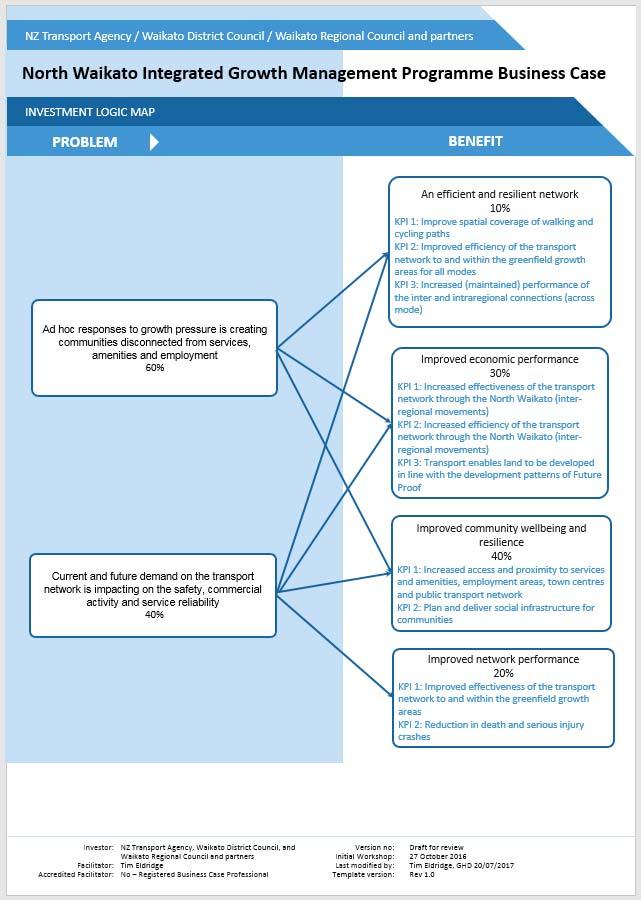
145
WELLINGTON $422 MILLION $614 MILLION $83 MILLION 22% SPEND $1.9 BILLION
 WELLINGTON WELLINGTON $1.9 BILLION FORECAST TOTAL WELLINGTON INVESTMENT The Wellington region s transport challenges are dominated by the region s concentration of population in the metropolitan cities,
$244 $45 OVERVIEW National Land Transport Programme Bay of Plenty BAY OF PLENTY REGIONAL SUMMARY
 2015 18 National Land Transport Programme Bay of Plenty BAY OF PLENTY REGIONAL SUMMARY OVERVIEW Transport investment in the Bay of Plenty is targeted to support significant residential growth, new industrial
CHRISTCHURCH MOTORWAYS. Project Summary Statement February 2010
 CHRISTCHURCH MOTORWAYS Project Summary Statement February 2010 Table of Contents 1. Purpose of Document 2. Strategic Context 3. Benefits 4. Project Scope and Economics 5. Implementation Plan 1 ROADS OF
TOWN PLANNING SUBMISSION TO THE GREATER SYDNEY COMMISSION LANDS AT ARTARMON
 TOWN PLANNING SUBMISSION TO THE GREATER SYDNEY COMMISSION LANDS AT ARTARMON March 2017 TABLE OF CONTENTS 1.0 INTRODUCTION 3 2.0 THE SUBJECT SITE 4 3.0 STRATEGIC PLANNING CONTEXT 6 4.0 SUMMARY AND CONCLUSIONS
5 Rail demand in Western Sydney
 5 Rail demand in Western Sydney About this chapter To better understand where new or enhanced rail services are needed, this chapter presents an overview of the existing and future demand on the rail network
Auckland Port and the Unitary Plan Dr Douglas Fairgray
 Auckland Port and the Unitary Plan Dr Douglas Fairgray Source: Auckland 1886 - Sir George Grey Special Collections, Auckland Libraries, NZ Map 374 Scope The interface between the Unitary Plan and the Port
ROTORUA INTEGRATED NETWORK STRATEGY
 ROTORUA INTEGRATED NETWORK STRATEGY 2012-2042 May 2013 This photo provided by RDC Cover photos provided by RDC and BOPRC Contents Context Issues for the Strategy to Address Outcomes and Interventions Implementation
Wellington $312 $49 $456 OVERVIEW WELLINGTON REGIONAL SUMMARY
 National Land Transport Programme 2015 18 Wellington WELLINGTON REGIONAL SUMMARY OVERVIEW The Wellington region is made up of a number of cities, urban areas and supporting rural hinterland. The city is
Hamilton City Council Transport Strategy
 Hamilton City Council Transport Strategy Where Does Access Hamilton Fit? Strategic Vision Deliver an affordable, integrated, safe, responsive and sustainable transport system. Support economic, social,
PERTH AND KINROSS COUNCIL. Enterprise and Infrastructure Committee 4 November 2009
 PERTH AND KINROSS COUNCIL 4 09/494 Enterprise and Infrastructure Committee 4 November 2009 STRATEGIC PRIORITIES FOR TOURISM AND AREA TOURISM PARTNERSHIP ARRANGEMENTS Report by Depute Director (Environment)
Wakatipu Area Strategy Plan
 Wakatipu Area Strategy Plan September 2009 Executive Summary The Ministry of Education has developed an area strategy plan in response to population growth in the Wakatipu area. The Ministry predicts that
30 th January Local Government s critical role in driving the tourism economy. January 2016 de Waal
 30 th January 2016 Local Government s critical role in driving the tourism economy January 2016 de Waal Contents Local Government can make or break tourism in their jurisdiction... 3 TNQ Tourism Vision...
DRAFT 2018 Update to the Waikato Regional Land Transport Plan
 DRAFT 2018 Update to the Waikato Regional Land Transport Plan 2015-2045 Chairman's foreword Waikato Regional 2018 update to the Waikato Regional Land Transport Plan 2015-2045 I am particularly pleased,
Waikato Plan. A SUMMARY Building champion communities, together. August 2017
 Waikato Plan A SUMMARY Building champion communities, together August 2017 The mighty Waikato region is a place of powerful possibilities. Forged by a proud history and shared excitement about the future,
Report to: Greater Cambridge Partnership Joint Assembly 18 January A10 Foxton level crossing bypass and travel hub
 Report to: Greater Cambridge Partnership Joint Assembly 18 January 2018 Lead officer: Chris Tunstall GCP Director of Transport A10 Foxton level crossing bypass and travel hub 1. Purpose 1.1 The list of
East Lancashire Highways and Transport Masterplan East Lancashire Rail Connectivity Study Conditional Output Statement (Appendix 'A' refers)
") Report to the Cabinet Member for Highways and Transport Report submitted by: Director of Corporate Commissioning Date: 1 June 2015 Part I Electoral Divisions affected: All East Lancashire Highways and
Report to the Cabinet Member for Highways and Transport Report submitted by: Director of Corporate Commissioning Date: 1 June 2015 Part I Electoral Divisions affected: All East Lancashire Highways and
Draft Marine and Harbour Facilities Strategy
 Draft Marine and Harbour Facilities Strategy Vision The Coromandel peninsula is a destination of choice for safe, sustainable and accessible marine and harbour facilities that are fit for purpose to meet
EAST WEST RAIL EASTERN SECTION. prospectus for growth
 EAST WEST RAIL EASTERN SECTION prospectus for growth September 2018 executive summary The East West Rail Consortium, a partnership of local authorities, rail operators and Network Rail, continues to promote
Draft Western District Plan
 Powered by TCPDF (www.tcpdf.org) Draft Western District Plan Submission_id: 31732 Date of Lodgment: 15 Dec 2017 Origin of Submission: Online Organisation name: APP Corporation Pty Ltd Organisation type:
Regional summary - Wellington
 Regional summary Wellington Regional summary - Wellington This is a summary of data relevant to transportation in this region, viewed from a Land Transport NZ perspective. It s purpose is to inform the
Submission to. Southland District Council on. Draft Stewart Island/Rakiura Visitor Levy Policy and Bylaw
 Submission to Southland District Council on Draft Stewart Island/Rakiura Visitor Levy Policy and Bylaw Date: 9 November 2018 Tourism Industry Aotearoa (TIA) welcomes the opportunity to comment on Southland
Draft Greater Sydney Region Plan
 Powered by TCPDF (www.tcpdf.org) Draft Greater Sydney Region Plan Submission_id: 31119 Date of Lodgment: 12 Dec 2017 Origin of Submission: Online Organisation name: Serapark Pty Ltd Organisation type:
Draft City Centre Transport Proposals
 Draft City Centre Transport Proposals Introduction This draft position paper provides an overview of the current City Centre transport issues, including concepts of the possible future City Centre transport
NATIONAL AIRSPACE POLICY OF NEW ZEALAND
 NATIONAL AIRSPACE POLICY OF NEW ZEALAND APRIL 2012 FOREWORD TO NATIONAL AIRSPACE POLICY STATEMENT When the government issued Connecting New Zealand, its policy direction for transport in August 2011, one
REGION OF WATERLOO INTERNATIONAL AIRPORT AIRPORT MASTER PLAN EXECUTIVE SUMMARY MARCH 2017
 REGION OF WATERLOO INTERNATIONAL AIRPORT AIRPORT MASTER PLAN EXECUTIVE SUMMARY MARCH 2017 Contact: Chris Wood, Airport General Manager cwood@regionofwaterloo.ca (519) 648-2256 ext. 8502 Airport Master
Consultation on Draft Airports National Policy Statement: new runway capacity and infrastructure at airports in the South East of England
 Tony Kershaw Honorary Secretary County Hall Chichester West Sussex PO19 1RQ Telephone 033022 22543 Website: www.gatcom.org.uk If calling ask for Mrs. Paula Street e-mail: secretary@gatcom.org.uk 22 May
The Government s Aviation Strategy Transport for the North (TfN) response
 response") The Government s Aviation Strategy Transport for the North (TfN) response Transport for the North Background Good transport links are a crucial part of a strong economy supporting labour markets and delivering
The Government s Aviation Strategy Transport for the North (TfN) response Transport for the North Background Good transport links are a crucial part of a strong economy supporting labour markets and delivering
AUCKLAND $1.2 BILLION $1.9 BILLION $149 MILLION 15% SPEND $5.7 BILLION
 AUCKLAND AUCKLAND $5.7 BILLION FORECAST TOTAL AUCKLAND INVESTMENT The next 10 years are expected to underline Auckland s performance as the fastest growing major city in Australasia. The city is expected
Involving Communities in Tourism Development Croatia
 Involving Communities in Tourism Development Croatia Case Study This case study outlines the approach from our project in two villages in the Makarska Riviera, Croatia, to explore the issue of local community
Kilometres. Blacktown. Penrith. Parramatta. Liverpool Bankstown. Campbelltown
 0 5 10 15 20 Kilometres Penrith Blacktown Parramatta Liverpool Bankstown Campbelltown accessibility outcomes Legend Outcomes targeted in Western Sydney are: public transport that is accessible throughout
A Response to: Belfast On The Move Transport Masterplan for Belfast City Centre, Sustainable Transport Enabling Measures
 West Belfast Partnership 218-226 Falls Road Belfast BT12 6AH T: 02890809202 A Response to: Belfast On The Move Transport Masterplan for Belfast City Centre, Sustainable Transport Enabling Measures Issued
Waikato Regional Economic Development Strategy
 Waikato Regional Economic Development Strategy 1 TO FROM Economic Development Committee Ben Dunbar-Smith - Economic Development Programme Manager DATE 6 April 2016 SUBJECT Waikato Regional Economic Development
Draft Greater Sydney Region Plan
 Draft Greater Sydney Region Plan Submission_id: 31392 Date of Lodgment: 14 Dec 2017 Origin of Submission: Online Organisation name: Greenfields Development Company No. 2 Pty Limited Organisation type:
N4 Carrick-on-Shannon to Dromod Road Project. 2.1 Introduction
 Chapter 2 Need for the Scheme 2.1 Introduction The National Primary Route N4, Dublin to Sligo is a strategic corridor from Dublin to the northwest and border counties (See RCSR 101 in Volume 2). The National
West London Economic Assessment
 West London Economic Assessment A baseline analysis of the West London economy An Executive Summary PBA were commissioned in October 2015 to complete an economic assessment of West London to refresh the
Rail Delivery Group. Consultation on the future of the East Midlands rail franchise
 Rail Delivery Group Response to: Department for Transport Consultation on the future of the East Midlands rail franchise Date: 11 October 2017 Rail Delivery Group Limited Registered Office, 2nd Floor,
The Sunshine Coast is part of the global community and generates wealth through export, high-value industries and new investment.
 3.2 Strategic intent 3.2.1 Shaping growth an overview In 2031, the Sunshine Coast is renowned for its vibrant economy, ecological values, unique character and strong sense of community. It is Australia
NSW PRE-BUDGET STATEMENT FUTURE ECONOMY FUTURE JOBS
 2017-18 NSW PRE-BUDGET STATEMENT FUTURE ECONOMY FUTURE JOBS Executive Summary The 2017-18 NSW State Budget presents an opportunity for the NSW Government to future-proof the tourism and transport sectors.
Submission to. Queenstown Lakes District Council. on the
 Submission to Queenstown Lakes District Council on the Queenstown Lakes District Proposed District Plan, Section 32 Evaluation, Stage 2 Components October 2017, for Visitor Accommodation Date: 23 Feb 2018
FUTURE TRANSPORT STRATEGY AND GREATER SYDNEY SERVICES AND INFRASTRUCTURE PLAN. Western Parkland City
 FUTURE TRANSPORT STRATEGY AND GREATER SYDNEY SERVICES AND INFRASTRUCTURE PLAN Western Parkland City 2 Transport for NSW Future Transport Strategy and Greater Sydney Services and Infrastructure Plan Western
Your Transport Levy Your Transport Future. Sunshine Coast Council Transport Levy Annual Report
 Your Transport Levy Your Transport Future Sunshine Coast Council Transport Levy Annual Report 2016-2017 www.sunshinecoast.qld.gov.au T 07 5475 7272 F 07 5475 7277 Locked Bag 72 Sunshine Coast Mail Centre
Tourism Development Plan for Scotland Questionnaire
 Draft National Tourism Development Plan Public Consultation 2013 Tourism Development Plan for Scotland Questionnaire We would like your views on this Plan and, in particular, your comments on opportunities
PSP 75 Lancefield Road. Northern Jacksons Creek Crossing Supplementary Information
 PSP 75 Lancefield Road Northern Jacksons Creek Crossing Supplementary Information September 2017 The northern crossing of Jacksons Creek proposed within the Lancefield Road PSP is a key part of the ultimate
Agenda Item 5: Rail East Midlands Rail Franchise Consultation
 Strategic Transport Forum 15 th September 2017 Agenda Item 5: Rail East Midlands Rail Franchise Consultation Recommendation: It is recommended that the Forum agree (subject to any amendments agreed by
A Master Plan is one of the most important documents that can be prepared by an Airport.
 The Master Plan A Master Plan is one of the most important documents that can be prepared by an Airport. A Master Plan is a visionary and a strategic document detailing planning initiatives for the Airport
Gold Coast: Modelled Future PIA Queensland Awards for Planning Excellence 2014 Nomination under Cutting Edge Research category
 Gold Coast: Modelled Future PIA Queensland Awards for Planning Excellence 2014 Nomination under Cutting Edge Research category Jointly nominated by SGS Economics and Planning and City of Gold Coast August
Revalidation: Recommendations from the Task and Finish Group
 Council meeting 12 January 2012 01.12/C/03 Public business Revalidation: Recommendations from the Task and Finish Group Purpose This paper provides a report on the work of the Revalidation Task and Finish
GISBORNE DISTRICT COUNCIL BUSINESS CASE PROPOSAL. Eastland Port Access. Pedestrian Safety Rakaiatane Rd. Page 1 of 4
 GISBORNE DISTRICT COUNCIL BUSINESS CASE PROPOSAL Eastland Port Access Pedestrian Safety Rakaiatane Rd Page 1 of 4 Introduction This proposal has been developed by Gisborne District Council (GDC) to provide
Report of the Strategic Director of Place to the meeting of Executive to be held on 11 September 2018
 Report of the Strategic Director of Place to the meeting of Executive to be held on 11 September 2018 Subject: M Arrangements for the establishment of a West Yorkshire Urban Traffic Management Control
Scotland s Water Industry: Past, Present and Future
 Scotland s Water Industry: Past, Present and Future A presentation by Katherine Russell Director of Strategy and Corporate Affairs Water Industry Commission for Scotland 16 June 2015 www.watercommission.co.uk
TRANSPORT FOR GREATER MANCHESTER COMMITTEE REPORT FOR RESOLUTION
 TRANSPORT FOR GREATER MANCHESTER COMMITTEE REPORT FOR RESOLUTION DATE: 11 November 2011 SUBJECT: REPORT OF: Proposed making of a Quality Partnership Scheme for the A6 corridor between Manchester and Hazel
Report on Hamilton to Auckland Passenger Rail
 Report on Hamilton to Auckland Passenger Rail Date: 12 April 2017 To: From: Subject: Hamilton City Council, Waikato District Council, Waikato Regional Council, NZ Transport Agency, Auckland Council, and
The implementation of this Master Plan will be undertaken in logical stages to meet passenger and workforce demands.
 The implementation of this Master Plan will be undertaken in logical stages to meet passenger and workforce demands. Connecting People Building Opportunities 198 Brisbane Airport Corporation CHAPTER 10
Response to the London Heathrow Airport Expansion Public Consultation
 Response to the London Heathrow Airport Expansion Public Consultation Summary This report sets out the response to the Heathrow Airport s consultation on airport expansion and airspace change. The consultation
PO Box 257 PO Box 257 PARRAMATTA NSW 2124 PARRAMATTA NSW 2124
 31 March 2017 Sean O Toole Sheridan Dudley District Commissioner - West District Commissioner - South West Greater Sydney Commission Greater Sydney Commission PO Box 257 PO Box 257 PARRAMATTA NSW 2124
South East Traffic Solution
 South East Traffic Solution A MAJORITY LIBERAL GOVERNMENT WILL: Complete the Hobart Airport Interchange project Fix the Tasman Highway near Tasmania Golf Club Replace the Midway Point Roundabout with additional
Transport Indicators Report June 2018
 Transport Indicators Report June 2018 Board Meeting 21 August 2018 Recommendation That the Board: i. Receives this report. Executive summary 1. The attached Monthly and Quarterly Indicator Reports provide
HEAD OF ECONOMIC PROMOTION AND PLANNING Nathan Spilsted, Senior Planning Officer Tel:
 7. TRAVELLER SITES ALLOCATIONS DOCUMENT REPORT OF: Contact Officer: Wards Affected: Key Decision: Report to: HEAD OF ECONOMIC PROMOTION AND PLANNING Nathan Spilsted, Senior Planning Officer Email: nathan.spilsted@midsussex.gov.uk
Clyde Waterfront and Renfrew Riverside Project Glasgow Airport Investment Area Project
 Item 1 To: Leadership Board On: 3 June 2015 Report by: Director of Development and Housing Services Heading: City Deal Strategic Business Cases 1. Summary 1.1 This report seeks approval from the Board
Performance Criteria for Assessing Airport Expansion Alternatives for the London Region
 Performance Criteria for Assessing Airport Expansion Alternatives for the London Region Jagoda Egeland International Transport Forum at the OECD TRB Annual Meeting 836 - Measuring Aviation System Performance:
PERTH AND KINROSS COUNCIL. Housing and Health Committee. 25 May Perth and Kinross Local Housing Strategy
 PERTH AND KINROSS COUNCIL 7 16/234 Housing and Health Committee 25 May 2016 Perth and Kinross Local Housing Strategy 2016-2021 Report by Director (Housing and Social Work) PURPOSE OF REPORT This report
REAUTHORISATION OF THE ALLIANCE BETWEEN AIR NEW ZEALAND AND CATHAY PACIFIC
 Chair Cabinet Economic Growth and Infrastructure Committee Office of the Minister of Transport REAUTHORISATION OF THE ALLIANCE BETWEEN AIR NEW ZEALAND AND CATHAY PACIFIC Proposal 1. I propose that the
Major Scheme Business Case Summary Report for Programme Entry
 Paper A Heart of South West Local Transport Board Major Scheme Business Case Summary Report for Programme Entry M5 Junction 25, Taunton July 2016 1 SCHEME SUMMARY Scheme Name M5 Junction 25, Taunton Date
Figure 1.1 St. John s Location. 2.0 Overview/Structure
 St. John s Region 1.0 Introduction Newfoundland and Labrador s most dominant service centre, St. John s (population = 100,645) is also the province s capital and largest community (Government of Newfoundland
an engineering, safety, environmental, traffic and economic assessment of each option to inform a preferred route option choice; 3) Development and as
 Development and as") Page: 42 Infrastructure Services REPORT TO ABERDEENSHIRE COUNCIL COMMITTEE 26 APRIL 2018 A96 ABERDEEN TO INVERNESS DUALLING POSITION STATEMENT 1 Recommendations Aberdeenshire Council is recommended to:
Page: 42 Infrastructure Services REPORT TO ABERDEENSHIRE COUNCIL COMMITTEE 26 APRIL 2018 A96 ABERDEEN TO INVERNESS DUALLING POSITION STATEMENT 1 Recommendations Aberdeenshire Council is recommended to:
Te Kowhai COMMUNITY PLAN
 1 2011-2021 Te Kowhai COMMUNITY PLAN Vision To realise a lifestyle potential 2 Map of Te Kowhai area 3 4 History of the plan In 2004 the Te Kowhai Community Group Committee and the residents put together
TAG Guidance Notes on responding to the Civil Aviation Authority s consultation on its Five Year Strategy
 TAG Guidance Notes on responding to the Civil Aviation Authority s consultation on its Five Year Strategy 1. Introduction (Deadline for consultation responses is 19 February 2016) The CAA is currently
Local Development Scheme
 Local Development Scheme August 2014 Local Development Scheme (August 2014) / Page 2 Contents Section 1: Introduction Great Yarmouth s Development Plan 4 Section 2: Plan Making Process Public participation
The Strategic Commercial and Procurement Manager
 Item 3 To: Procurement Sub Committee On: 8 June 2016 Report by: The Strategic Commercial and Procurement Manager Heading: Renfrewshire Council s Community Benefit Strategy 2016 1. Summary 1.1. The purpose
Team London Bridge Response to the Department for Transport Consultation on the combined Thameslink, Southern and Great Northern franchise
 Team London Bridge Response to the Department for Transport Consultation on the combined Thameslink, Southern and Great Northern franchise 23 August 2012 Table of Contents 1. Executive Summary 2. Introduction
Inland Queensland Roads Action Plan
 Inland Queensland Roads Action Plan Creating jobs. Driving Productivity. Attracting Investment Glenys Schuntner IQ-RAP Secretariat RDA Townsville and North West Queensland Chief Executive Officer Overview
Manawatu District Economic Profile
 Manawatu District Economic Profile Our community Population has grown by 1,000 residents since 2014 to reach 29,800. Population is 86.4% European, with Maori 14.3% of the population. This compares with
Whangarei Airport. Prepared by Carine Andries 10/20173
 Whangarei Airport Prepared by Carine Andries 10/20173 March 2010 TABLE OF CONTENTS 1 2 3 INTRODUCTION... 3 AIRPORT ROLE AND FUNCTION... 3 AIRPORT FEATURES AND CAPACITY... 3 3.1 3.2 3.3 3.4 3.5 3.5.1 3.5.2
CAIRNS RECTANGULAR PITCH STADIUM NEEDS STUDY PART 1 CAIRNS REGIONAL COUNCIL DRAFT REPORT SEPTEMBER 2011
 CAIRNS RECTANGULAR PITCH STADIUM NEEDS STUDY PART 1 CAIRNS REGIONAL COUNCIL DRAFT REPORT SEPTEMBER 2011 CAIRNS RECTANGULAR PITCH STADIUM NEEDS STUDY PART 1 Cairns Regional Council September 2011 Coffey
The Belfast Manifesto
 TheBelfast Manifesto NIIRTA The Northern Ireland Independent Retail Trade Association (NIIRTA) strongly supports The Belfast Manifesto. This should be required reading for election candidates to both Belfast
PERTH AND KINROSS COUNCIL. 22 June 2016 DEVELOPING THE CULTURAL OFFER IN PERTH AND KINROSS UPDATE AND NEXT STEPS
 PERTH AND KINROSS COUNCIL 8 16/278 22 June 2016 DEVELOPING THE CULTURAL OFFER IN PERTH AND KINROSS UPDATE AND NEXT STEPS Report by Senior Depute Chief Executive (Equality, Community Planning & Public Service
Parkland County Municipal Development Plan Amendment Acheson Industrial Area Structure Plan
 Parkland County Municipal Development Plan Amendment Acheson Industrial Area Structure Plan New Plan Acheson Industrial Area Structure Plan Amendment Parkland County Municipal Development Plan Board Reference
Airways New Zealand Queenstown lights proposal Public submissions document
 Airways New Zealand Queenstown lights proposal 2014 Public submissions document Version 1.0 12 December, 2014 Contents 1 Introduction... 3 2 Purpose... 3 3 Air New Zealand Limited... 4 3.1 Proposed changes
Upper Clutha Transport Report
 Upper Clutha Transport Report Shaping our Future Vision for the Upper Clutha incorporating Land, Air and Water Transport: The Queenstown Lakes District has a functional, innovative, integrated, multi-modal
2. Our response follows the structure of the consultation document and covers the following issues in turn:
 Virgin Atlantic Airways response to the CAA s consultation on Economic regulation of capacity expansion at Heathrow: policy update and consultation (CAP 1658) Introduction 1. Virgin Atlantic Airways (VAA)
Activity Concept Note:
 Activity Concept Note: Summary Provide a short summary of the proposed Activity including indicative New Zealand funding level and note whether this is a New Zealandled or partner-led process. Why: Rationale
7. CONSULTATION ON THE TRAVELLER SITES ALLOCATIONS DOCUMENT
 7. CONSULTATION ON THE TRAVELLER SITES ALLOCATIONS DOCUMENT REPORT OF: HEAD OF ECONOMIC PROMOTION AND PLANNING Contact Officer: Nathan Spilsted, Senior Planning Officer Email: nathan.splistead@midsussex.gov.uk
[REGIONAL LAND TRANSPORT PROGRAM AND REGIONAL FUEL TAX SUBMISSION ]
![[REGIONAL LAND TRANSPORT PROGRAM AND REGIONAL FUEL TAX SUBMISSION ]](/thumbs/89/99007492.jpg "[REGIONAL LAND TRANSPORT PROGRAM AND REGIONAL FUEL TAX SUBMISSION ]") 2018 Ben Ross Talking Southern Auckland Picture 1: Manukau Bus Station with MIT and rail station in the background [REGIONAL LAND TRANSPORT PROGRAM AND REGIONAL FUEL TAX SUBMISSION ] Submission to the
2018 Ben Ross Talking Southern Auckland Picture 1: Manukau Bus Station with MIT and rail station in the background [REGIONAL LAND TRANSPORT PROGRAM AND REGIONAL FUEL TAX SUBMISSION ] Submission to the
Gold Coast. Rapid Transit. Chapter twelve Social impact. Chapter content
 Gold Coast Rapid Transit Chapter twelve Social impact Chapter content Social impact assessment process...235 Existing community profile...237 Consultation...238 Social impacts and mitigation strategies...239
Director, External Trade, CARICOM Secretariat. CARICOM Secretariat, Guyana
 THE COMMONWEALTH SECREATARIAT SEEKS APPLICATIONS FOR THE POST OF REGIONAL TRADE ADVISER (RTA) FOR AN ASSIGNMENT WITH THE CARIBBEAN COMMUNITY (CARICOM) SECRETARIAT DATE REQUIRED: December 2014 REPORTING
ENVIRONMENT ACTION PLAN
 ENVIRONMENT ACTION PLAN 2015 16 Airservices Australia 2015 This work is copyright. Apart from any use as permitted under the Copyright Act 1968, no part may be reproduced by any process without prior written
Train Stations are not just arrival and departure locations
 Train Stations are not just arrival and departure locations The Railway Study Association Mike Goggin 31 October 2017 Contents Introduction to Steer Davies Gleave The Passenger The Neighbour & Non-Traveller
Auckland Transport Quarterly Indicators Report 2018/19
 Attachment 1 Auckland Transport ly Indicators Report 218/19 September 218 Table of Contents Page 2. 1. Executive summary 2. External indicators 3. Performance by Key Priority 3.1 Deliver an efficient and
Strategic Transport Forum 7 th December 2018
 Strategic Transport Forum 7 th December 2018 Agenda Item 7: East West Rail Recommendation: It is recommended that the Forum: a) Endorse the East West Rail Consortium s position in relation to the draft
Public Submissions in response to the Bill closed on 2 July 2015 and Council lodged a copy of the submission provided as Attachment 1.
 54 PLANNING AND ECONOMIC COMMITTEE 8 JULY 2015 3 SUSTAINABLE PORTS DEVELOPMENT BILL Neil Quinn 1/58/14 #4771706 RECOMMENDATION: That Council endorses the Submission made to the Infrastructure, Planning
Urban Cycleways Programme Announcement Questions and Answers
 Urban s Programme Announcement Questions and Answers 1. What is the Urban s Programme? The Urban s Programme is an investment of $100 million over the next four years, dedicated to urban cycling infrastructure.
Inter-Regional Planning Uniting both Urban and Provincial Centres
 Inter-Regional Planning Uniting both Urban and Provincial Centres Looking at how to solve pressures and problems in Urban and Provincial Centres while linking to Sustainability and Planning Ben Ross. 2017
Submission to. Christchurch City Council. on the. Draft Long Term Plan Date: 12 April 2018
 Submission to Christchurch City Council on the Draft Long Term Plan 2018-2028 Date: 12 April 2018 Tourism Industry Aotearoa (TIA) welcomes the opportunity to comment on the Long Term Plan 2018-2028 of
Co-ordinated and Orderly Growth A Suite of Infrastructure and Public Assets for the Future... 1
 Co-ordinated and Orderly Growth... 1 A Suite of Infrastructure and Public Assets for the Future... 1 Funding Sources, Revenues and Prioritising Expenditure... 2 Stage 1 Short Term Growth Sunbury to 50,000...
TERMINAL DEVELOPMENT PLAN
 5.0 TERMINAL DEVELOPMENT PLAN 5.0 TERMINAL DEVELOPMENT PLAN Key points The development plan in the Master Plan includes the expansion of terminal infrastructure, creating integrated terminals for international,
PAGE 602
 PAGE 601 PAGE 602 PAGE 603 PAGE 604 PAGE 605 PAGE 606 PAGE 607 PAGE 608 PAGE 609 PAGE 610 PAGE 611 PAGE 612 PAGE 613 PAGE 614 PAGE 615 PAGE 616 PAGE 617 PAGE 618 PAGE 619 PAGE 620 PAGE 621 PAGE 622 PAGE
Submission to. Palmerston North City Council. on the. Draft Long Term Plan Date: 23 April 2018
 Submission to Palmerston North City Council on the Draft Long Term Plan 2018-2028 Date: 23 April 2018 Tourism Industry Aotearoa (TIA) welcomes the opportunity to comment on the Long Term Plan 2018-2028
Coastal Tourism The End of the Line or a Renaissance Waiting to Happen? Jason Freezer Associate Director National Coastal Tourism Academy
 Coastal Tourism The End of the Line or a Renaissance Waiting to Happen? Jason Freezer Associate Director National Coastal Tourism Academy 60 73 67 106 247 241 243 238 Coastal Tourism Big Business at a
CONGESTION MONITORING THE NEW ZEALAND EXPERIENCE. By Mike Curran, Manager Strategic Policy, Transit New Zealand
 CONGESTION MONITORING THE NEW ZEALAND EXPERIENCE 26 th Australasian Transport Research Forum Wellington New Zealand 1-3 October 2003 By, Manager Strategic Policy, Transit New Zealand Abstract New Zealand
Gold Coast. Rapid Transit. Chapter content. Chapter four Route selection and staging
 Chapter four Route selection and staging Gold Coast Rapid Transit Chapter four Route selection and staging Chapter content Route selection...73 Section one: Helensvale to Griffith University...74 Section