Lincoln Regional Airport Compatibility Policies and Maps
|
|
|
- Peregrine Smith
- 5 years ago
- Views:
Transcription
1 Chapter 6 Lincoln Regional Airport Compatibility Policies and Maps Placer County Airport Land Use Compatibility Plan
2
3 6 Lincoln Regional Airport Compatibility Policies and Maps 6.1. Evaluating Land Use Consistency Evaluating Compatibility of New Development: The compatibility of proposed land uses within the Lincoln Regional Airport Influence Area shall be evaluated in accordance with: (a) The specific noise, safety, airspace protection, overflight, and other compatibility policies set forth in Chapter 3; (b) The criteria listed in Table LIN-6A, Basic Compatibility Criteria, and (c) The Compatibility Zones depicted on the Compatibility Policy Map (Map LIN-6A) in this chapter Compatibility Policy Table: Table LIN-6A, Basic Compatibility Criteria, lists general land use categories and indicates each use as being normally compatible, conditional, or incompatible depending upon the compatibility zone in which it is located Compatibility Policy Map: The Compatibility Zones for Lincoln Regional Airport are presented in Map LIN-6A and are to be used in conjunction with the criteria set forth in Table LIN-6A and the additional policies listed in Policy of this Chapter Airspace Protection Surfaces Map: The Airspace Protection Surfaces Map for Lincoln Regional Airport is presented in Map LIN-6B and is to be used in conjunction with the airspace protection policies set forth in Section 3.5 of Chapter Map Determinants Airport Runway Configuration Assumptions: Map LIN-6A and Map LIN-6B are based upon the Lincoln Regional Airport runway configuration indicated in the Airport Master Plan report adopted by the City of Lincoln in 27 and the Airport Layout Plan drawing dated 28 submitted by the city and approved by the Federal Aviation Administration. These plans propose a 1,-foot northerly extension of the existing runway together with construction of a 3,35-foot parallel secondary runway on the east side of the existing primary runway. Placer County Airport Land Use Compatibility Plan (Adopted February 26, 214) 6 1
4 CHAPTER 6 LINCOLN REGIONAL AIRPORT COMPATIBILITY POLICIES AND MAPS Compatibility Policy Map Boundary Determinants: The Compatibility Zone boundaries for Lincoln Regional Airport represent a composite of four compatibility factors: noise, safety, airspace protection and overflight concerns. 53 The Airport s runway length, approach categories, normal flight patterns, and aircraft fleet mix influence the shape and size of the Compatibility Zones. 54 The magnitude of the Airport impacts occurring within each Compatibility Zone is described below. The outer limits of the Compatibility Zone boundaries define the Airport Influence Area. 55 (a) Compatibility Zone A includes the Airport runways and immediately adjacent areas wherein uses are restricted to aeronautical functions in accordance with Federal Aviation Administration (FAA) standards and state guidance provided in the 211 California Airport Land Use Planning Handbook (Handbook). Compatibility Zone A encompasses the area adjacent to and at the ends of the future runway system, which includes the proposed northerly extension of the primary runway and future parallel runway. The width is based upon FAR Part 77 primary surface requirements as shown on the current Lincoln Regional Airport Airspace Protection Surfaces Map (LIN-6B). The length contains the existing and future runway protection zone (RPZ) of each runway as depicted in the 28 Airport Layout Plan. RPZ dimensions are defined by FAA airport design standards and take into account the runway approach type and the type of aircraft the runway is intended to accommodate. In terms of risk, Compatibility Zone A encompasses the areas covered by the generic Safety Zone 1 provided in the 211 Handbook. Compatibility Zone A is characterized as an area exposed to high risk of an aircraft accident as well as subject to high aircraft noise levels. The Community Noise Equivalent Level (CNEL) exceeds 65 db within much of Compatibility Zone A. (b) Compatibility Zone B1 encompasses the portions of the runway approach/departure areas adjacent to and beyond the ends of the RPZ (Compatibility Zone A). The length of the zone is primarily determined by the type of approach procedure existing or planned at each runway end. Noise levels and risks are both high in these areas. Cumulative noise levels are generally at least CNEL 55 db. Also, noise produced by individual aircraft operations is often high enough to disrupt many land use activities. In terms of risk, Compatibility Zone B1 encompasses the majority of the areas covered by Handbook Safety Zone 2 and portions of Zone 3. At the south end of the airport, Compatibility Zone B1 includes all of Handbook Safety Zone 2 for a medium general aviation runway and 8% of Safety Zone 2 for a long general aviation runway. Compatibility Zone B1 excludes 2% of Safety Zone 2 for the following reasons: Safety Zone 2 assumes approach visibility minimums of less than ¾ mile. The airport s nonprecision instrument approach is anticipated to remain at visibility minimums of no less than 1 mile. Landings on Runway 33 are anticipated to comprise less than 15% of total annual airport operations. Majority of operations (85%) are conducted from north to south. Aircraft are anticipated to reach sufficient altitude before reaching Highway 65 thus minimizing safety hazards and overflight annoyance. The proposed runway extension will also 53 Appendix C provides the basic concepts and rationale for addressing the four compatibility concerns. 54 Chapter 9 summarizes the aeronautical data influencing the geographic extents of the four compatibility factors. 55 Chapter 2, Policy defines the term Airport Influence Area. 6 2 Placer County Airport Land Use Compatibility Plan (Adopted February 26, 214)
5 LINCOLN REGIONAL AIRPORT COMPATIBILITY POLICIES AND MAPS CHAPTER 6 enable departing aircraft to be at a higher altitude over the communities south of Highway 65. A significant amount of light general aviation traffic is anticipated to shift to the parallel runway if/when it is constructed. The portion of Safety Zone 2 beyond Compatibility Zone B1 primarily encompasses Highway 65, the future highway interchange and anticipated highway commercial uses. Risk levels are high because of the proximity of Compatibility Zone B1 to the runway ends and because these areas are overflown by aircraft at low altitudes typically only 2 to 4 feet above the runway elevation. The length of the zone is primarily set with respect to the point at which aircraft pass below 3 feet above the ground when approaching the runway on a straight-in instrument approach. This distance also encompasses the CNEL 6 db contour. Additionally, restrictions on the height of objects (generally not less than 5 feet) may be required for airspace protection purposes. Compatibility Zone B1 reflect both noise and safety concerns consistent with the types of instrument approach procedures established at the Airport, the types of aircraft which operate there, and the projected volume of aircraft activity. (c) Compatibility Zone B2 consists of two areas adjacent to Compatibility Zone A, one on each side of the runways. The length of the zone is based on the length of the future runways. The width of the zone takes into account the future runway and is set so as to generally contain the future CNEL 6 db contour. Sideline aircraft noise is the key factor in this area, both cumulative and single-event. Run-up noise may also be a concern in some locations. Risk is also a factor, but less so than in Compatibility Zone B1. The zone also encompasses Handbook Safety Zone 5. Height restrictions may be required for airspace protection purposes. (d) Compatibility Zone C1 covers the extended approach/departure corridor and lands adjacent to Compatibility Zone B2 lateral of the runway. This zone is affected by moderate degrees of both noise and risk. Cumulative noise levels exceed CNEL 55 db in portions of Compatibility Zone C1 and noise from individual aircraft operations is disruptive to Noise-Sensitive Land Uses. Aircraft overfly this area at or below the traffic pattern altitude of 1, feet above the runway elevation. According to the data presented in the Caltrans Handbook, 4% to 5% of off-runway, airport-related, general aviation aircraft accidents occur within Compatibility Zones B1 and C1 for comparable airports. Compatibility Zone C1 also encompasses the remaining portions of Handbook Safety Zones 3 and 4 and the inner portions of Zone 6. Extensions of the zone are established to the north and south because aircraft on instrument approaches may overfly these areas at altitudes under 6 feet above the ground. Portions of Compatibility Zone C1 lie beneath the Federal Aviation Regulations Part 77 transitional surface airspace restrictions may be required on tall objects (ones greater than 1 feet high). Noise from individual aircraft operations is a factor in these locations. (e) Compatibility Zone C2 encompasses east and west traffic patterns for the primary runway, as well as the pattern for the potential future parallel runway. The zone includes locations along the pattern entry routes and beneath wide patterns flown by large aircraft. Compatibility Zone C2 encompasses the outer portions of Handbook Safety Zone 6. Aircraft typically overfly these areas at an altitude of 1, to 1,5 feet above ground level on visual approaches. Annoyance associated with aircraft overflights is the major Placer County Airport Land Use Compatibility Plan (Adopted February 26, 214) 6 3
6 CHAPTER 6 LINCOLN REGIONAL AIRPORT COMPATIBILITY POLICIES AND MAPS concern within Compatibility Zone C2. Although the zone lies outside the CNEL 55 db contour, noise from individual aircraft overflights may adversely affect certain land uses. Safety is a concern only with regard to uses involving high concentrations of people and particularly risk-sensitive uses such as schools and hospitals. (f) Compatibility Zone D areas are sometimes overflown by aircraft arriving and departing the Airport. Hazards to flight are the only compatibility concern. The outer limits of the zone coincide with the outer edge of the conical surface defined by FAR Part 77 for each airport. Height limits are no less than 15 feet within this area Special Conditions Policy: In accordance with Policy 3.2.3(b) of Chapter 3, the ALUC acknowledges a special conditions policy for Lincoln Regional Airport in the adoption of this ALUCP. The special conditions result in establishment of compatibility criteria different in character from the criteria applicable to other portions of the Compatibility Zones. These special policies are not to be generalized or considered as precedent applicable to other locations near the same Airport or to the environs of other Airports addressed by this ALUCP. (a) The new municipal wastewater treatment facility located south of Moore Road within the outer end of Compatibility Zone D (some 2.3 miles south of the Airport) is deemed to be consistent with the Policy 3.5.3(a)(6) in Chapter 3 of this ALUCP regarding avoidance of land uses which increase the attraction of birds. This finding is based upon the city s intent to maintain the facility so as to minimize its attraction of birds to the extent feasible. 6 4 Placer County Airport Land Use Compatibility Plan (Adopted February 26, 214)
7 LINCOLN REGIONAL AIRPORT-SPECIFIC COMPATIBILITY POLICIES AND MAPS CHAPTER 6 Intensity Criteria 1 Max. Sitewide Average Intensity (people/acre) Max. Single-Acre Intensity (people/acre) Open Land Requirement 2 Land Use Category Multiple land use categories may apply to a project Land uses not specifically listed shall be evaluated using the criteria for similar uses Typical occupancy Load Factor [approx. # s.f./person] indicated for certain uses 3 General Characteristics Any use having more than 1 habitable floor 4 Any use having structures (including poles or antennas) or trees 35 to 15 feet in height Any use having structures (including poles, antennas, or cranes) or trees more than 15 feet in height Any use having the potential to cause an increase in the attraction of birds or other wildlife Any use creating visual or electronic hazards to flight 6 Outdoor Uses (no or limited indoor activities) Natural Land Areas: woods, brush lands, desert Water: flood plains, wetlands, lakes, reservoirs, rivers, detention/retention ponds Agriculture (except residences and livestock): field crops, orchards, vineyards, pasture, range land Compatibility Zones A B1 B2 C1 C2 D all remain g % no ,2 no limit 15% 1% no Legend (see last page of table for interpretation) Normally Compatible Conditional Incompatible Intensity Criteria Interpretation All nonresidential development shall satisfy both sitewide and single-acre intensity limits See Policy for application Additional Criteria Conditions listed below apply to uses listed as Conditional (yellow) for a particular zone Numbers in yellow cells are Floor Area Ratios (FARs) based on typical occupancy load factor indicated for that use and average intensity limit indicated for zone B1, B2: Limited to no more than 2 habitable floors C1: Limited to no more than 3 habitable floors B1, B2, C1: Ensure airspace obstruction does not occur B1, B2: Airspace review required for objects >35 feet C1: Airspace review required for objects >7 feet C2, D: Ensure airspace obstruction does not occur; airspace review required for objects >15 feet C1, C2, D: Avoid use or provide mitigation consistent with FAA rules and regulations 5 A: Objects above runway elevation not allowed in OFA 7 A, B1, B2: Vegetation must be clear of airspace surfaces A: Objects above runway elevation not allowed in OFA 7 All: Avoid new features that attract birds or provide mitigation consistent with FAA regulations 5 A: Not allowed in OFA 7 All: Avoid new features that attract birds or provide mitigation consistent with FAA regulations 5 Table LIN-6A Basic Compatibility Criteria Lincoln Regional Airport Placer County Airport Land Use Compatibility Plan (Adopted February 26, 214) 6 5
8 CHAPTER 6 LINCOLN REGIONAL AIRPORT-SPECIFIC COMPATIBILITY POLICIES AND MAPS Intensity Criteria 1 Max. Sitewide Average Intensity (people/acre) Max. Single-Acre Intensity (people/acre) Open Land Requirement 2 Land Use Category Multiple land use categories may apply to a project Land uses not specifically listed shall be evaluated using the criteria for similar uses Typical occupancy Load Factor [approx. # s.f./person] indicated for certain uses 3 Livestock Uses: feed lots, stockyards, breeding, fish hatcheries, horse/riding stables, poultry and dairy farms Outdoor Major Assembly Facilities (capacity 1, people): spectator-oriented outdoor stadiums, amphitheaters, fairgrounds, race tracks, water parks, zoos Outdoor Large Assembly Facilities (capacity 3 to 999 people): spectator-oriented outdoor stadiums, amphitheaters Outdoor Group Recreation (limited spectator stands): athletic fields, water recreation facilities (community pools), picnic areas Outdoor Non-Group Recreation (small/lowintensity): golf courses (except clubhouse), tennis courts, shooting ranges Local Parks: neighborhood parks, playgrounds Camping: campgrounds, recreational vehicle/ motor home parks Cemeteries (except chapels) Residential and Lodging Uses Single-Family Residential: individual dwellings, townhouses, mobile homes, bed and breakfast inns Multi-Family Residential: townhouses, apartments condominiums Long-Term Lodging (>3 nights): extendedstay hotels, dormitories Compatibility Zones A B1 B2 C1 C2 D all remain g % no ,2 no limit 15% 1% no Legend (see last page of table for interpretation) Normally Compatible Conditional Incompatible Intensity Criteria Interpretation All nonresidential development shall satisfy both sitewide and single-acre intensity limits See Policy for application Additional Criteria Conditions listed below apply to uses listed as Conditional (yellow) for a particular zone Numbers in yellow cells are Floor Area Ratios (FARs) based on typical occupancy load factor indicated for that use and average intensity limit indicated for zone B1, B2, C1, C2, D: Avoid new features that attract birds or provide mitigation consistent with FAA regulations 5 ; exercise caution with uses involving noise-sensitive animals C2, D: Allowed only if alternative site outside zone would not serve intended function; ensure intensity criteria met; exercise caution if clear audibility by users is essential C2: Ensure intensity criteria met; not allowed if intended primarily for use by children; exercise caution if clear audibility by users is essential C1, C2: Ensure intensity criteria met; not allowed if intended primarily for use by children; exercise caution if clear audibility by users is essential B1, B2, C1: Ensure intensity criteria met; not allowed if intended primarily for use by children; exercise caution if clear audibility by users is essential B1, B2: Must have little or no permanent recreational facilities (ball fields, etc.); exercise caution if clear audibility by users is essential C1: Ensure intensity criteria met; avoid if disruption by aircraft noise unacceptable B1, B2, C1: Ensure intensity criteria met; avoid if disruption by aircraft noise unacceptable B1, B2: 1 du/1 acres (average density); 4 du/single acre 8 ; CNEL 45 db max. interior noise level C1: 1 du/2 acres (average density); 4 du/single acre 8 B1: B2, C1: Locate dwelling max. distance from extended runway centerline where feasible C1: Ensure intensity criteria met Table LIN-6A, continued 6 6 Placer County Airport Land Use Compatibility Plan (Adopted February 26, 214)
9 LINCOLN REGIONAL AIRPORT-SPECIFIC COMPATIBILITY POLICIES AND MAPS CHAPTER 6 Intensity Criteria 1 Max. Sitewide Average Intensity (people/acre) Max. Single-Acre Intensity (people/acre) Open Land Requirement 2 Land Use Category Multiple land use categories may apply to a project Land uses not specifically listed shall be evaluated using the criteria for similar uses Typical occupancy Load Factor [approx. # s.f./person] indicated for certain uses 3 Compatibility Zones A B1 B2 C1 C2 D all remain g % no ,2 no limit 15% 1% no Legend (see last page of table for interpretation) Normally Compatible Conditional Incompatible Intensity Criteria Interpretation All nonresidential development shall satisfy both sitewide and single-acre intensity limits See Policy for application Additional Criteria Conditions listed below apply to uses listed as Conditional (yellow) for a particular zone Numbers in yellow cells are Floor Area Ratios (FARs) based on typical occupancy load factor indicated for that use and average intensity limit indicated for zone Short-Term Lodging (3 nights, except conference/assembly facilities): hotels, motels, other transient lodging [approx. 2 s.f./person] Congregate Care: retirement homes, assisted living/residential care facilities, intermediate care facilities Educational and Institutional Uses Family day care homes (14 children) 9 Children s Schools: K-12, day care centers (>14 children), libraries Adult Education classroom space: adult schools, colleges, universities [approx. 4 s.f./person] Indoor Major Assembly Facilities (capacity 1, people): auditoriums, conference centers, resorts, concert halls, indoor arenas Indoor Large Assembly Facilities (capacity 3 to 999 people): movie theaters, places of worship, cemetery chapels, mortuaries [approx. 15 s.f./person] Indoor Small Assembly Facilities (capacity <3 people): community libraries; art galleries; museums; exhibition space, community/senior centers, emergency/ homeless shelters [approx. 1 s.f./person] Indoor Recreation: gymnasiums, club houses, athletic clubs, dance studios, sports complexes (indoor soccer), health clubs, spas [approx. 6 s.f./person] In-Patient Medical: hospitals, mental hospitals, nursing homes C1, C2: Ensure intensity criteria met C2: Ensure intensity criteria met B1, B2: CNEL 45 db max. interior noise level C2: Allowed only if alternative site outside zone would not serve intended function; ensure intensity criteria met; exercise caution if clear audibility by users is essential B2, C1, C2: Ensure intensity criteria met C2, D: Allowed only if alternative site outside zone would not serve intended function; ensure intensity criteria met; exercise caution if clear audibility by users is essential C1, C2: Ensure intensity criteria met B2, C1, C2: Ensure intensity criteria met; not allowed if intended primarily for use by children; avoid outdoor spaces intended for noisesensitive activities B2, C1, C2: Ensure intensity criteria met; not allowed if intended primarily for use by children C2: Allowed only if alternative site outside zone would not serve intended function; ensure intensity criteria met; exercise caution if clear audibility by users is essential Table LIN-6A, continued Placer County Airport Land Use Compatibility Plan (Adopted February 26, 214) 6 7
10 CHAPTER 6 LINCOLN REGIONAL AIRPORT-SPECIFIC COMPATIBILITY POLICIES AND MAPS Intensity Criteria 1 Max. Sitewide Average Intensity (people/acre) Max. Single-Acre Intensity (people/acre) Open Land Requirement 2 Land Use Category Multiple land use categories may apply to a project Land uses not specifically listed shall be evaluated using the criteria for similar uses Typical occupancy Load Factor [approx. # s.f./person] indicated for certain uses 3 Compatibility Zones A B1 B2 C1 C2 D all remain g % no ,2 no limit 15% 1% no Legend (see last page of table for interpretation) Normally Compatible Conditional Incompatible Intensity Criteria Interpretation All nonresidential development shall satisfy both sitewide and single-acre intensity limits See Policy for application Additional Criteria Conditions listed below apply to uses listed as Conditional (yellow) for a particular zone Numbers in yellow cells are Floor Area Ratios (FARs) based on typical occupancy load factor indicated for that use and average intensity limit indicated for zone Out-Patient Medical: health care centers, clinics [approx. 24 s.f./person] Penal Institutions: prisons, reformatories Public Safety Facilities: police, fire stations Commercial, Office, and Service Uses Major Retail (capacity >3 people per building): regional shopping centers, big box retail, supermarket [approx. 11 s.f./person] Local Retail ( 3 people per building): community/neighborhood shopping centers, grocery stores [approx. 17 s.f./person] Eating/Drinking Establishments: restaurants, bars, fast-food dining [approx. 6 s.f./person] Limited Retail/Wholesale: furniture, automobiles, heavy equipment, building materials, hardware, lumber yards, nurseries [approx. 25 s.f./person] Offices: professional services, doctors, finance, banks, civic; radio, television and recording studios, office space associated with other listed uses [approx. 215 s.f./person] Personal and Miscellaneous Services: barbers, car washes, print shops [approx. 2 s.f./person] Fueling Facilities: gas stations, trucking and other transportation fueling facilities B2, C1, C2: Ensure intensity criteria met B2: CNEL 45 db max. interior noise level B2: Allowed only if airport serving C1: Allowed only if site outside zone would not serve intended function; ensure intensity criteria met C1, C2: Ensure intensity criteria met B2, C1: Ensure intensity criteria met B1, B2, C1, C2: Ensure intensity criteria met B1: Locate structure max. distance from extended runway centerline where feasible B1, B2, C1, C2: Ensure intensity criteria met B1: Locate structure max. distance from extended runway centerline where feasible B1, B2, C1: Ensure intensity criteria met B1: Locate structure max. distance from extended runway centerline where feasible B1, B2, C1, C2: Ensure intensity criteria met B1, B2, C1: Ensure intensity criteria met B1, B2: Store fuel underground or in aboveground storage tanks with combined max. capacity of 6, gallons B1: Locate structure max. distance from extended runway centerline where feasible Table LIN-6A, continued 6 8 Placer County Airport Land Use Compatibility Plan (Adopted February 26, 214)
11 LINCOLN REGIONAL AIRPORT-SPECIFIC COMPATIBILITY POLICIES AND MAPS CHAPTER 6 Intensity Criteria 1 Max. Sitewide Average Intensity (people/acre) Max. Single-Acre Intensity (people/acre) Open Land Requirement 2 Land Use Category Multiple land use categories may apply to a project Land uses not specifically listed shall be evaluated using the criteria for similar uses Typical occupancy Load Factor [approx. # s.f./person] indicated for certain uses 3 Compatibility Zones A B1 B2 C1 C2 D all remain g % no ,2 no limit 15% 1% no Legend (see last page of table for interpretation) Normally Compatible Conditional Incompatible Intensity Criteria Interpretation All nonresidential development shall satisfy both sitewide and single-acre intensity limits See Policy for application Additional Criteria Conditions listed below apply to uses listed as Conditional (yellow) for a particular zone Numbers in yellow cells are Floor Area Ratios (FARs) based on typical occupancy load factor indicated for that use and average intensity limit indicated for zone Industrial, Manufacturing, and Storage Uses Hazardous Materials Production and Storage (flammable, explosive, corrosive, or toxic): oil refineries, chemical plants D: Allowed only if alternative site outside zone would not serve intended function; generation of steam or thermal plumes not allowed Heavy Industrial C2, D: Bulk storage of hazardous materials allowed only for on-site use; permitting agencies to evaluate possible need for special measures to minimize hazards if struck by aircraft; generation of steam or thermal plumes not allowed Light Industrial, High Intensity: food products preparation, electronic equipment, bottling plant [approx. 2 s.f./person] Light Industrial, Low Intensity: machine shops, wood products, auto repair [approx. 35 s.f./person] Research and Development Laboratories [approx. 3 s.f./person] Indoor Storage: wholesale sales, distribution centers, warehouses, mini/other indoor storage, barns, greenhouses [approx. 1, s.f./person] Outdoor Storage: public works yards, automobile dismantling B2, C1, C2: Ensure intensity criteria are met; bulk storage of hazardous (flammable, explosive, corrosive, or toxic) materials allowed only for on-site use; permitting agencies to evaluate possible need for special measures to minimize hazards if struck by aircraft B1, B2, C1: Ensure intensity criteria are met; bulk storage of hazardous (flammable, explosive, corrosive, or toxic) materials allowed only for on-site use; permitting agencies to evaluate possible need for special measures to minimize hazards if struck by aircraft B1, B2, C1, C2: Ensure intensity criteria are met; bulk storage of hazardous (flammable, explosive, corrosive, or toxic) materials allowed only for on-site use; permitting agencies to evaluate possible need for special measures to minimize hazards if struck by aircraft B1: Locate structure max. distance from extended runway centerline where feasible B1, B2: Ensure intensity criteria are met; ensure airspace obstruction does not occur B1: Ensure intensity criteria are met; ensure airspace obstruction does not occur Table LIN-6A, continued Placer County Airport Land Use Compatibility Plan (Adopted February 26, 214) 6 9
12 CHAPTER 6 LINCOLN REGIONAL AIRPORT-SPECIFIC COMPATIBILITY POLICIES AND MAPS Intensity Criteria 1 Max. Sitewide Average Intensity (people/acre) Max. Single-Acre Intensity (people/acre) Open Land Requirement 2 Land Use Category Multiple land use categories may apply to a project Land uses not specifically listed shall be evaluated using the criteria for similar uses Typical occupancy Load Factor [approx. # s.f./person] indicated for certain uses 3 Compatibility Zones A B1 B2 C1 C2 D all remain g % no ,2 no limit 15% 1% no Legend (see last page of table for interpretation) Normally Compatible Conditional Incompatible Intensity Criteria Interpretation All nonresidential development shall satisfy both sitewide and single-acre intensity limits See Policy for application Additional Criteria Conditions listed below apply to uses listed as Conditional (yellow) for a particular zone Numbers in yellow cells are Floor Area Ratios (FARs) based on typical occupancy load factor indicated for that use and average intensity limit indicated for zone Mining and Extraction B1, B2, C1, C2: Generation of dust clouds, smoke, steam plumes not allowed; ensure airspace obstruction does not occur Transportation, Communication, and Utilities Airport Terminals: airline, general aviation Transportation Stations: Rail/bus stations; taxi, trucking and other transportation terminals Transportation Routes: road and rail transit lines, rights-of-way, bus stops Auto Parking: surface lots, structures B1, B2, C1: Ensure intensity criteria met; ensure airspace obstruction does not occur B1: Avoid road intersections if traffic congestion occurs; ensure airspace obstruction does not occur B1: Ensure airspace obstruction does not occur Communications Facilities: broadcast and cell towers, emergency communications Power Plants: primary, peaker, renewable energy, bio-energy C1, C2: Allowed only if site outside zone would not serve intended public function; locate structures max. distance from extended runway centerline; ensure all facilities and associated power lines meet airspace protection criteria (height, thermal plumes, glare, etc.) C1, C2: Peaker and renewable energy plants allowed if structures located max. distance from extended runway centerline D: Primary plants allowed only if site outside zone would not serve intended public function; locate structures max. distance from extended runway centerline All: Ensure all facilities and associated power lines meet airspace protection criteria (height, thermal plumes, glare, etc.) Electrical Substations C1, C2: Locate structure max. distance from extended runway centerline; ensure all facilities and associated power lines meet airspace protection criteria (height, thermal plumes, glare, etc.) Table LIN-6A, continued 6 1 Placer County Airport Land Use Compatibility Plan (Adopted February 26, 214)
13 LINCOLN REGIONAL AIRPORT-SPECIFIC COMPATIBILITY POLICIES AND MAPS CHAPTER 6 Intensity Criteria 1 Max. Sitewide Average Intensity (people/acre) Max. Single-Acre Intensity (people/acre) Open Land Requirement 2 Land Use Category Multiple land use categories may apply to a project Land uses not specifically listed shall be evaluated using the criteria for similar uses Typical occupancy Load Factor [approx. # s.f./person] indicated for certain uses 3 Wastewater Facilities: treatment, disposal Solid Waste Disposal Facilities: landfill, incineration Solid Waste Transfer Facilities, Recycle Centers Compatibility Zones A B1 B2 C1 C2 D all remain g % no ,2 no limit 15% 1% no Legend (see last page of table for interpretation) Normally Compatible Conditional Incompatible Intensity Criteria Interpretation All nonresidential development shall satisfy both sitewide and single-acre intensity limits See Policy for application Additional Criteria Conditions listed below apply to uses listed as Conditional (yellow) for a particular zone Numbers in yellow cells are Floor Area Ratios (FARs) based on typical occupancy load factor indicated for that use and average intensity limit indicated for zone C1, C2: Allowed only if site outside zone would not serve intended public function; avoid new features that attract birds or provide mitigation consistent with FAA regulations 5 D: Allowed only if site outside zone would not serve intended public function; avoid new features that attract birds or provide mitigation consistent with FAA regulations 5 D: Allowed only if site outside zone would not serve intended public function; avoid new features that attract birds or provide mitigation consistent with FAA regulations 5 Table LIN-6A, continued Placer County Airport Land Use Compatibility Plan (Adopted February 26, 214) 6 11
14 CHAPTER 6 LINCOLN REGIONAL AIRPORT-SPECIFIC COMPATIBILITY POLICIES AND MAPS Land Use Acceptability Normally Compatible Conditional Generally Incompatible Interpretation/Comments Normal examples of the use are compatible with noise, safety, and airspace protection criteria. Atypical examples may require review to ensure compliance with usage intensity, lot coverage, and height limit criteria. Use is compatible if indicated usage intensity, lot coverage, and other listed conditions are met. For the purposes of these criteria, avoid is intended as cautionary guidance, not a prohibition of the use. Use should not be permitted under any circumstances. Notes Indicates land use that is or may be highly noise sensitive. Exercise caution with regard to approval of outdoor uses evaluate potential for aircraft noise to disrupt the activity. Indoor uses may require addition of sound attenuation to structure. See Section 3.1 for criteria. Indicates land use that may attract birds, generate dust, produce smoke or steam plumes, create electronic interference, or otherwise pose hazards to flight. See Policy 3.5.3(a) for criteria. 1 Intensity criteria apply to all nonresidential uses including ones shown as Normally Compatible (green) and Conditional (yellow). Usage intensity calculations shall include all people (e.g., employees, customers/visitors) who may be on the property at any single point in time, whether indoors or outdoors (see Policy 3.4.2(e)). Exceptions can be made for rare special events (e.g., an air show at the airport, street fair) for which a facility is not designed and normally not used and for which extra safety precautions can be taken as appropriate (see Policy 3.2.5). The usage intensities shall be calculated in accordance with the methodologies cited in Policy and Open land requirements are intended to be applied with respect to an entire zone (see Policy 3.4.1). This is typically accomplished as part of a local general plan or specific plan, but may also apply to large (1 acres or more) development projects. 3 Occupancy Load Factors [approx. number of square feet per person] cited for many listed land use categories are based on information from various sources and are intended to represent typical busy-period usage (or peak usage) for typical examples of the land use category. These Occupancy Load Factors differ from those provided in the California Building Code (CBC), as the CBC considers the absolute maximum number of people that can be safely accommodated in a building. See Policy 3.4.3(a)(2). 4 The intent of this criterion is to facilitate evacuation of a building if it were to be hit by an aircraft. It is separate from the height limits set for airspace protection purposes. 5 No proposed use shall be allowed that would create an increased attraction for wildlife and that is inconsistent with FAA rules and regulations including, but not limited to, FAA Advisory Circular 15/52-33B, Hazardous Wildlife Attractants On or Near Airports and Advisory Circular 15/52-34A, Construction or Establishment of Landfills near Public Airports. Of particular concern are landfills and certain recreational or agricultural uses that attract large flocks of birds which pose bird strike hazards to aircraft in flight. See Policy 3.5.3(a)(6). 6 Specific characteristics to be avoided include: sources of glare (such as from mirrored or other highly reflective structures or building features) or bright lights (including search lights and laser light displays); distracting lights that could be mistaken for airport lights; sources of dust, steam, or smoke that may impair pilots vision; sources of steam or other emissions that cause thermal plumes or other forms of unstable air; and sources of electrical interference with aircraft communications or navigation. See Policy 3.5.3(a). 7 Object Free Area (OFA): Dimensions are established by FAA airport design standards for the runway. See Airport maps in Chapters 5 through 7. 8 Clustering of residential development is permitted. However, no single acre of a project site shall exceed the indicated number of dwelling units per acre. See Policy 3.4.1(d). 9 Family day care home means a home that regularly provides care, protection, and supervision for 14 or fewer children, in the provider s own home, for periods of less than 24 hours per day. Small family day care homes provide care for eight or fewer children and large family day care homes provide care for 7 to 14 children (Health and Safety Code Section ). Table LIN-6A, continued 6 12 Placer County Airport Land Use Compatibility Plan (Adopted February 26, 214)
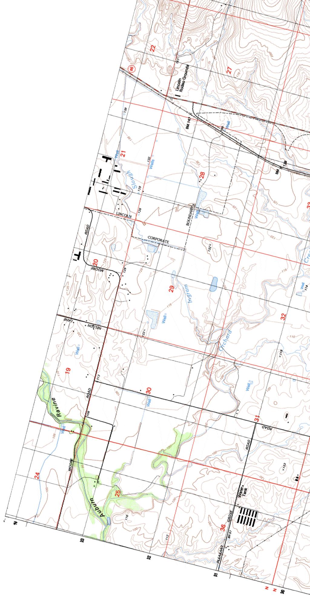
15 LINCOLN REGIONAL AIRPORT COMPATIBILITY POLICIES AND MAPS CHAPTER 6 Community of Sheridan Legend Yuba County Placer County D C2 2,' 5,' C1 5,8' 75' 2,5' 1,5' B2 2,5' 2' 2' 1,' A D 14,' C2 B L B2 2,5' 3' 1,' 7' 7,5' 7,5' 33 33R D Boundary Lines Placer County Limits Lincoln City Limits Lincoln Sphere of Influence Existing Airport Property Line Future Airport Property Line Future Avigation Easement Existing Runway (6, ft.) Future Runway 15R-33L (7, ft.) Future Runway 15L-33R (3,35 ft.) 1 Compatibility Zones (Adopted 214) Notes: # Airport Influence Area Zone A Zone B1 Zone B2 Zone C1 Zone C2 Zone D See Special Conditions Policy This ALUCP utilizes composite compatibility zones addressing four compatibility concerns: noise, safety, overflight and airspace protection. 2. Longitudinal dimensions measure from end of primary surface, 2' from ends of runway. C:\Users\87tme\appdata\local\temp\AcPublish_15212\LIN-compatibility 213.dwg Mar 13, 214-1:13pm Prepared By: 5,' FEET 1,' D C2 5,' 12,' 1,7' B1 C1 1,' C2 D LINCOLN Map LIN-6A Compatibility Policy Map Lincoln Regional Airport


16 CHAPTER 6 C:\Users\87tme\appdata\local\temp\AcPublish_19316\LIN-airspace.dwg Mar 12, 214-2:59pm LINCOLN REGIONAL AIRPORT COMPATIBILITY POLICIES AND MAPS 2:1 CONICAL SURFACE HORIZONTAL SURFACE 4,' 4:1 APPROACH SURFACE Map LIN-6B 5:1 APPROACH SLOPE FEET 8,' 7:1 TRANSITIONAL SURFACE PRIMARY SURFACE Prepared By: RUNWAY TYPICAL FAR PART 77 SURFACES Airspace Protection Surfaces Map Lincoln Regional Airport
Airport Land Use Compatibility Plan (ALUCP) Update. Public Information Meeting #4 June 8 & 9, 2016
 Update. Public Information Meeting #4 June 8 & 9, 2016") Airport Land Use Compatibility Plan (ALUCP) Update Public Information Meeting #4 June 8 & 9, 2016 Agenda 1. Study Process 2. Noise Complaint Patterns 3. Proposed Overflight Areas (AOA) 4. Proposed Land
Airport Land Use Compatibility Plan (ALUCP) Update Public Information Meeting #4 June 8 & 9, 2016 Agenda 1. Study Process 2. Noise Complaint Patterns 3. Proposed Overflight Areas (AOA) 4. Proposed Land
Comparison Between Old and New ALUC Plans
 A P P E N I X H Comparison Between Old and New ALUC Plans OVERVIEW This Placer County Airport Land Use Compatibility Plan (ALUCP) sets forth land use compatibility criteria for the environs of Auburn Municipal,
Flying Cloud Airport (FCM) Zoning Process: Informing a Mn/DOT Path Forward
 Zoning Process: Informing a Mn/DOT Path Forward") : Informing a Mn/DOT Path Forward A Review of the Flying Cloud Airport (FCM) Joint Airport Zoning Board (JAZB) Process and the Draft Airport Zoning Ordinance B A RPZ RPZ A B C Zone Chad E. Leqve Director
: Informing a Mn/DOT Path Forward A Review of the Flying Cloud Airport (FCM) Joint Airport Zoning Board (JAZB) Process and the Draft Airport Zoning Ordinance B A RPZ RPZ A B C Zone Chad E. Leqve Director
STAFF REPORT. Airport Land Use Plan Consistency Review: Old Town Village Mixed Use Project City of Goleta. MEETING DATE: June 18, 2015 AGENDA ITEM: 5M
 STAFF REPORT SUBJECT: Airport Land Use Plan Consistency Review: Old Town Village Mixed Use Project City of Goleta MEETING DATE: AGENDA ITEM: 5M STAFF CONTACT: Peter Imhof, Andrew Orfila RECOMMENDATION:
APPENDIX K LAND USE. Charles M. Schulz - Sonoma County Airport Draft Environmental Impact Report July 2011 K-1
 APPENDIX K LAND USE Charles M. Schulz - Sonoma County Airport Draft Environmental Impact Report July 2011 K-1 Appendix K Land Use THIS PAGE INTENTIONALLY LEFT BLANK Charles M. Schulz - Sonoma County Airport
at: Accessed May 4, 2011.
 3.11 SAFETY 3.11.1 Background and Methodology As with other forms of transportation, there is risk associated with aviation activities. This section focuses on risk to those on the ground near airports.
STAFF REPORT. Airport Land Use Consistency Determination Betteravia Plaza. MEETING DATE: January 21, 2016 AGENDA ITEM: 8D
 STAFF REPORT SUBJECT: Airport Land Use Consistency Determination Betteravia Plaza MEETING DATE: AGENDA ITEM: 8D STAFF CONTACT: Andrew Orfila RECOMMENDATION: Adopt findings for the Betteravia Plaza project
The following criteria shall be applied within the boundaries of the AO District:
 Sec. 419 (a) Purpose AIRPORT OVERLAY DISTRICT (AO) The purpose of the Airport Overlay District is to regulate and restrict the height of structures, objects, or natural growth, regulate the locations of
ARTICLE 34 AIRPORT HEIGHT COMBINING ZONE (AH) (Amended by Ordinance #295 Effective June 26, 2009)
 (Amended by Ordinance #295 Effective June 26, 2009)") ARTICLE 34 AIRPORT HEIGHT COMBINING ZONE (AH) (Amended by Ordinance #295 Effective June 26, 2009) Section 34.10 - Purpose and Intent The purpose of the Airport Height Combining Zone (AH) is to protect
ARTICLE 34 AIRPORT HEIGHT COMBINING ZONE (AH) (Amended by Ordinance #295 Effective June 26, 2009) Section 34.10 - Purpose and Intent The purpose of the Airport Height Combining Zone (AH) is to protect
Chapter Six ALP Drawings. Tacoma Narrows Airport. Master Plan Update
 Chapter Six ALP Drawings Master Plan Update The master planning process for the (Airport) has evolved through efforts in the previous chapters to analyze future aviation demand, establish airside and landside
Airport Land Use Compatibility Plan (ALUCP) Update. Public Information Meeting #2 December 1, 2015
 Update. Public Information Meeting #2 December 1, 2015") Airport Land Use Compatibility Plan (ALUCP) Update Public Information Meeting #2 December 1, 2015 Agenda 1. Welcome and Introductions 2. Status of Study 3. Long-term Planning Activity Level Annual Service
Airport Land Use Compatibility Plan (ALUCP) Update Public Information Meeting #2 December 1, 2015 Agenda 1. Welcome and Introductions 2. Status of Study 3. Long-term Planning Activity Level Annual Service
SCHEDULE OF USE REGULATIONS BY DISTRICTS.
 158.033 SCHEDULE OF USE REGULATIONS BY DISTRICTS. The following schedule sets forth the permitted uses and special uses for the various zoning districts. (A) Pre urbanized District, P 1. Agriculture Animal
Background Data: Blue Canyon Airport and Environs
 5 Background Data: and Environs INTRODUCTION serves as an important emergency landing field amid mountainous terrain. The airport has existed on the site since the 1930s or 40s. The facility was operated
CA CA CA CA CA CA CA CA CA CA Educational facilities - public elementary and high schools and private schools with a curriculum similar to public
 (Y = Permitted) TABLE A (CA = Contract Agreement) PERMITTED USES BY DISTRICT Agricultural Uses (Light) Farming & Livestock related activities Y Y Y Y Y Y Agricultural Uses (Heavy) Commercial Type Animal
Appendix C AIRPORT LAYOUT PLANS
 Appendix C AIRPORT LAYOUT PLANS Appendix C AIRPORT LAYOUT PLANS Airport Master Plan Santa Barbara Airport As part of this Airport Master Plan, the Federal Aviation Administration (FAA) requires the development
Notice of Extended Comment Period for an Intent to Adopt a Negative Declaration
 County of Santa Clara Department of Planning and Development Planning Office County Government Center, East Wing, 7 th Floor 70 West Hedding Street San Jose, California 95110-1705 (408) 299-5770 FAX (408)
City of Fort Pierce ARTICLE III. - BASIC ZONING DISTRICTS
 ity of Fort Pierce ARTILE III. - BASI ZONING DISTRITS Sec. 22-22. - Allowed uses. (a) Uses listed. Uses listed are allowed in each zoning district in accordance with the Use Table. (b) Permitted uses.
APPENDIX C NOISE ANALYSIS
 APPENDIX C NOISE ANALYSIS KBE Final - 10/11/16 Existing Noise The extent of existing noise resulting from aircraft operations at Central Colorado Regional Airport (AEJ) was determined using the FAA-approved
STAFF REPORT. Airport Land Use Plan Consistency Review: Santa Barbara Airport Master Plan. MEETING DATE: November 19, 2015 AGENDA ITEM: 7D
 STAFF REPORT SUBJECT: Airport Land Use Plan Consistency Review: Santa Barbara Airport Master Plan MEETING DATE: AGENDA ITEM: 7D STAFF CONTACT: Peter Imhof, Andrew Orfila RECOMMENDATION: Adopt findings
AIRPORT LAND USE COMPATILIBILTY AIRPORT LAND USE COMPATIBILIITY
 CHAPTER 7 AIRPORT LAND USE COMPATILIBILTY CHAPTER 7 AIRPORT LAND USE COMPATIBILIITY 7.0 INTRODUCTION On airport aviation related development is typically compatible with aircraft operations. On airport
Chapter 9 - AIRPORT SYSTEM DESIGN
 Chapter 9 - AIRPORT SYSTEM DESIGN 9.01 GENERAL This chapter discusses the development program for Dutchess County Airport to the year 2020. This airport system design is based upon the airport's existing
SCHEDULE B CLASSIFICATION OF USES OF LAND AND BUILDINGS
 Torbay Municipal Plan 2015-2025, Schedule B Page 1 SCHEDULE B CLASSIFICATION OF OF LAND AND BUILDINGS A. ASSEMBLY 1. Uses for the production and viewing of the performing arts. (a) Theatre Motion Picture
Background Data: Lincoln Regional Airport and Environs
 6 Background Data: and Environs INTRODUCTION /Karl Harder Field is a former military training airfield built during World War II on a mile-square section of open rangeland some three miles west of central
AIRSIDE CAPACITY AND FACILITY REQUIREMENTS
 AIRSIDE CAPACITY AND FACILITY REQUIREMENTS This Section investigates the capacity of the airport, its ability to meet current demand, and the facilities required to meet forecasted needs as established
DRAFT MASTER PLAN UPDATE
 DRAFT MASTER PLAN UPDATE CHAPTER VI: AIRPORT LAYOUT PLAN NARRATIVE DRAFT REPORT APRIL 2017 PREPARED BY: Table of Contents WESTCHESTER COUNTY AIRPORT 6 AIRPORT LAYOUT PLAN NARRATIVE REPORT... 6-1 6.1 AGIS
2015 PURDUE ROAD SCHOOL March 11, 2015
 2015 PURDUE ROAD SCHOOL March 11, 2015 Runway Protection Zone (RPZ) Definition It is a trapezoidal shape formed off the end of a runway and its geometry it a function of the airport s aircraft approach
Article 11 Airport District
 Cities County A Article 11 Article 11 Section 11.01 Intent (a) A. The A is established to provide for uses, activities, facilities, and structures necessary for the safe and efficient operation of aircraft
ORDINANCE NO. _2013-
 ORDINANCE NO. _2013- AN ORDINANCE OF THE TOWNSHIP OF CONEWAGO, DAUPHIN COUNTY, PENNSYLVANIA, PROVIDING FOR AIRPORT ZONING REGULATIONS WITHIN THE AIRPORT ZONING OVERLAY DISTRICT CREATED BY THIS ORDINANCE
Airport Master Plan Update
 Duttchessss Countty Airrporrtt Masstterr Plan Updatte Airport Master Plan Update Final Report Dutchess County Airport Town of Wappingers, New York C&S Engineers, Inc. 499 Col. Eileen Collins Blvd. Syracuse,
Airport Obstruction Standards
 Airport Obstruction Standards Dr. Antonio Trani Department of Civil and Environmental Engineering Virginia Tech Outline of this Presentation Obstructions to navigation around airports Discussion of Federal
CHAPTER 1 EXECUTIVE SUMMARY
 CHAPTER 1 EXECUTIVE SUMMARY 1 1 EXECUTIVE SUMMARY INTRODUCTION William R. Fairchild International Airport (CLM) is located approximately three miles west of the city of Port Angeles, Washington. The airport
Background Data: Blue Canyon Airport and Environs
 Chapter 8 Background ata: and Environs Placer County Airport Land Use Compatibility Plan 8 Background ata: and Environs INTROUCTION serves as an important emergency landing field amid mountainous terrain.
Apartment, Security - P - P P P P P P P P Sections 42.2 & Assisted Living Facility - C C C C C C - - C - Section 42.21
 TABLE 18-A RESIDENTIAL USES 8/7/2014 RESIDENTIAL USES R1 R2 AG NMU DC OC HC GI RI HS AS Section Reference Apartment, Accessory (accessory use) E P P P P P P - - - - Section 42.21 & 42.23 Apartment, Inlaw
Airport Background Data and Assumptions Report New Cuyama Airport. Santa Barbara County Airport Land Use Compatibility Plan Update
 Airport Background Data and Assumptions Report Santa Barbara County Airport Land Use Compatibility Plan Update June 25, 212 Updated August 17, 217 Airport Background Data and Assumptions Report 1. Introduction
Consideration will be given to other methods of compliance which may be presented to the Authority.
 Advisory Circular AC 139-10 Revision 1 Control of Obstacles 27 April 2007 General Civil Aviation Authority advisory circulars (AC) contain information about standards, practices and procedures that the
CHAPTER 6 NOISE EXPOSURE
 CHAPTER 6 NOISE EXPOSURE FAA requires that the NEM submitted for review represent the aircraft noise exposure for the year of submittal (in this case 2008) and for a future year (2013 for OSUA). However,
ERIE INTERNATIONAL AIRPORT MASTER PLAN TABLE OF CONTENTS
 EXECUTIVE SUMMARY ERIE INTERNATIONAL AIRPORT MASTER PLAN TABLE OF CONTENTS PAGE NO. CHAPTER 1-INTRODUCTION... 1-1 1.01 General...1-1 1.02 Purpose and Scope of Study...1-1 1.03 The Planning Process...1-2
PLANNING AND ZONING MEETING. March 20, 2019 AGENDA. 1. Review Minutes. 1
 PLANNING AND ZONING MEETING March 20, 2019 AGENDA 1. Review Minutes. 1 2. Appointments A. Land Use Map Discussion Horrocks Engineers.. 2 B. Airport Protection Ordinance. 3-8 3. Other Business 4. Adjourn
Document prepared by MnDOT Office of Aeronautics and HNTB Corporation. MINNESOTA GO STATE AVIATION SYSTEM PLAN
 LAST UPDATE JULY 2013 Acknowledgements The preparation of this document was financed in part by a grant from the Federal Aviation Administration (Project No: 3-27-0000-07-10), with the financial support
APPENDIX D FEDERAL AVIATION REGULATIONS, PART 77
 APPENDIX D FEDERAL AVIATION REGULATIONS, PART 77 Subparts A through C PART 77 - OBJECTS AFFECTING NAVIGABLE AIRSPACE Subpart A General 77.1 Scope. 77.2 Definition of terms. 77.3 Standards. 77.5 Kinds of
City of Upland, California September 2014 Draft
 Cable Airport Land Use Compatibility Plan City of Upland, California September 2014 Draft Cable Airport Land Use Compatibility Plan September 2014 Draft Prepared for City of Upland, California Prepared
Airport Planning Area
 PLANNING AREA POLICIES l AIRPORT Airport Planning Area LOCATION AND CONTEXT The Airport Planning Area ( Airport area ) is a key part of Boise s economy and transportation network; it features a multi-purpose
According to FAA Advisory Circular 150/5060-5, Airport Capacity and Delay, the elements that affect airfield capacity include:
 4.1 INTRODUCTION The previous chapters have described the existing facilities and provided planning guidelines as well as a forecast of demand for aviation activity at North Perry Airport. The demand/capacity
ORDINANCE NO. JACKSON TOWNSHIP, CAMBRIA COUNTY
 ORDINANCE NO. JACKSON TOWNSHIP, CAMBRIA COUNTY AN ORDINANCE OF THE TOWNSHIP OF JACKSON AMENDING SECTIONS OF THE JACKSON TOWNSHIP ZONING ORDINANCE AS FOLLOWS: PROVIDING NEW DEFINITIONS OF CAMPGROUNDS, CAMPSITE,
Finance and Implementation
 5 Finance and Implementation IMPLEMENTATION The previous chapters have presented discussions and plans for development of the airfield, terminal, and building areas at Sonoma County Airport. This chapter
Appendix B Ultimate Airport Capacity and Delay Simulation Modeling Analysis
 Appendix B ULTIMATE AIRPORT CAPACITY & DELAY SIMULATION MODELING ANALYSIS B TABLE OF CONTENTS EXHIBITS TABLES B.1 Introduction... 1 B.2 Simulation Modeling Assumption and Methodology... 4 B.2.1 Runway
Zoning Use Table. SU SU SU SU SU SU P Temporary Conversions to Allow Accessory Apartments
 Zoning Use Table Single-Family Dwellings P P P P P P P P Single-Family, Two-Family, and Multi-Family Dwellings P Temporary Conversions to Allow Accessory Apartments Open Space Subdivisions Cluster Subdivisions
Airport Land-Use Compatibility
 Airport Land-Use Compatibility Partnering for Airspace Viability at the Watertown International Airport Photo by: Watertown Daily Times Presented by: Grant Sussey, Airport Manager Jefferson County Andy
AIRSPACE PROTECTION. Guidance and considerations for development in the vicinity of Ohio s airports and heliports
 AIRSPACE PROTECTION Guidance and considerations for development in the vicinity of Ohio s airports and heliports UPDATED SPRING 2018 AIRSPACE PROTECTION When construction is proposed near public use airports
Draft Concept Alternatives Analysis for the Inaugural Airport Program September 2005
 Section 10 Preferred Inaugural Airport Concept 10.0 Introduction The Preferred Inaugural Airport Concept for SSA was developed by adding the preferred support/ancillary facilities selected in Section 9
PLAN Anoka County - Blaine Airport
 Reliever Airports: NOISE ABATEMENT PLAN Anoka County - Blaine Airport INTRODUCTION The noise abatement plan for the Anoka County-Blaine Airport was prepared in recognition of the need to make the airport
Planning Challenges and Solutions
 2007 AirTAP Fall Forum Planning Challenges and Solutions Matt Romanik Past Interim Airport Manager, Grand Rapids Itaska County Airport Gina Mitchell Planner, Bolton & Menk Inc. Kathy Vesely Zoning Coordinator
FRENCH VALLEY AIRPORT (F70) Sky Canyon Dr. Murrieta, CA. Phone: Riverside FAA FSDO Complaint Line: (951)
 Sky Canyon Dr. Murrieta, CA. Phone: Riverside FAA FSDO Complaint Line: (951)") FRENCH VALLEY AIRPORT (F70) 37600 Sky Canyon Dr. Murrieta, CA Phone: 951-600-7297 Riverside FAA FSDO Complaint Line: (951) 276-6701 Visit the F70 website for additional information regarding the airport
FRENCH VALLEY AIRPORT (F70) 37600 Sky Canyon Dr. Murrieta, CA Phone: 951-600-7297 Riverside FAA FSDO Complaint Line: (951) 276-6701 Visit the F70 website for additional information regarding the airport
St. Paul Downtown Airport (STP)
") Reliever Airports: NOISE ABATEMENT PLAN St. Paul Downtown Airport (STP) 1 INTRODUCTION The noise abatement plan for the St. Paul Downtown Airport (STP) was prepared in recognition of the need to make the
Reliever Airports: NOISE ABATEMENT PLAN St. Paul Downtown Airport (STP) 1 INTRODUCTION The noise abatement plan for the St. Paul Downtown Airport (STP) was prepared in recognition of the need to make the
APPENDIX F LAND USE PLANNING FOR AIRPORTS AND POCATELLO REGIONAL AIRPORT LAND USE COMPLIANCE
 APPENDIX F LAND USE PLANNING FOR AIRPORTS AND POCATELLO REGIONAL AIRPORT LAND USE COMPLIANCE Pocatello Regional Airport Airport Master Plan APPENDIX F LAND USE PLANNING FOR AIRPORT AND POCATELLO REGIONAL
MONTEREY REGIONAL AIRPORT MASTER PLAN TOPICAL QUESTIONS FROM THE PLANNING ADVISORY COMMITTEE AND TOPICAL RESPONSES
 MONTEREY REGIONAL AIRPORT MASTER PLAN TOPICAL QUESTIONS FROM THE PLANNING ADVISORY COMMITTEE AND TOPICAL RESPONSES Recurring topics emerged in some of the comments and questions raised by members of the
Guidance material for land use at or near aerodromes
 Guidance material for land use at or near aerodromes Table of Contents Overview... 1 Glossary... 1 Types of Aerodromes... 1 Obstacle Limitation Surfaces... 2 Wildlife Hazard Management... 2 Notice of Intention
Updates to Procedures at St. John s International Airport
 October 10, 2017 Updates to Procedures at St. John s International Airport This document provides notice of upcoming changes to instrument procedures being implemented by NAV CANADA at the St. John s International
 COUNTY SANITATION DISTRICT NO. 4 SERVICE CHARGE REPORT FOR FISCAL YEAR 2018-19 INTRODUCTION County Sanitation District No. 4 of Los Angeles County encompasses all or portions of the cities of Beverly Hills,
Airport Master Plan Update June 15, 2017
 Airport Master Plan Update June 15, 2017 www.harveyfield.com The Master Plan is a 20-year plan to understand the needs of current and future users of the Airport. This is important to ensure that safe
Appendices. Merced County Airport Land Use Compatibility Plan
 Appendices Merced County Airport Land Use Compatibility Plan A P P E N D I X A Foundations of Airport Land Use Compatibility Planning INTRODUCTION This appendix outlines the policy foundations upon which
Dallas Executive Airport
 648 DECLARED DISTANCE OPTION 1a DISPLACE 31 THRESHOLD BY 97 Considers RSA Limiting Factor No runway extensions 13 31 TORA 6,451 6,451 TODA 6,451 6,451 ASDA 5,958 6,451 LDA 5,958 6,354 Runway 17-35 (3,8
Boise Municipal Code. Chapter DEFINITIONS
 Chapter 12-03 DEFINITIONS Sections: 12-03-01 ADMINISTRATOR 12-03-02 AIRPORT DESIGNATIONS 12-03-03 AIRPORT HAZARD 12-03-04 AIRPORT HEIGHT LIMITATIONS 12-03-05 AIRPORT REFERENCE POINT 12-03-06 AIRPORT INSTRUMENT
Preliminary Findings of Proposed Alternative
 Preliminary Findings of Proposed Alternative The attached drawing provides a schematic layout of the proposed alternative that will be discussed on July 27, 2010. A full report will follow and should be
Background Data: Lincoln Regional Airport and Environs
 Chapter 9 Background ata: and Environs Placer County Airport Land Use Compatibility Plan 9 Background ata: and Environs INTROUCTION /Karl Harder Field is a former military training airfield built during
Agenda: SASP SAC Meeting 3
 Agenda: SASP SAC Meeting 3 Date: 04/12/18 Public Involvement Plan Update Defining the System Recommended Classifications Discussion Break Review current system Outreach what we heard Proposed changes Classification
RECREATIONAL VEHICLE RESORT DISTRICT R-RVR. Lacombe County Land Use Bylaw No: 1237/17 Date Adopted: July 6, Page 111
 RECREATIONAL VEHICLE RESORT DISTRICT Page 111 7.10 RECREATIONAL VEHICLE RESORT DISTRICT () 1 PURPOSE 2 USES The purpose of the Recreational Vehicle Resort District is to provide an area that will facilitate
Learning More About: Protecting and Evaluating Airspace for Airports
 Learning More About: Protecting and Evaluating Airspace for Airports Introduction Tall structures, smoke, and Tall Structures rising terrain are just a few conditions that can create hazardous conditions
COUNTY SANITATION DISTRICT NO. 14 SERVICE CHARGE REPORT FOR FISCAL YEAR
 COUNTY SANITATION DISTRICT NO. 14 SERVICE CHARGE REPORT FOR FISCAL YEAR 2017-18 INTRODUCTION County Sanitation District No. 14 of Los Angeles County encompasses portions of the cities of Lancaster and
447 Route 28 West Yarmouth MA 02673
 CAREY COMMERCIAL, INC. BUSINESS & INVESTMENT PROPERTY 146 MAIN STREET HYANNIS, MA 02601 for sale 2 ACRES OF COMMERCIAL LAND 447 Route 28 West Yarmouth MA 02673 Contact: Chuck Carey 508-790-8900 Ext. 11
Airport Master Plan Update June 15, 2017
 Airport Master Plan Update June 15, 2017 www.harveyfield.com The Master Plan is a 20-year plan to understand the needs of current and future users of the Airport. This is important to ensure that safe
New Opportunities PUBLIC WORKSHOP. Venice Municipal. Bringing g the pieces together
 Bringing g the PUBLIC WORKSHOP Venice Municipal Airport New Opportunities Presented for Venice City Council & Citizens of Venice September 25, 2009 Slide 1 Bringing g the Welcome & Introductions May 12th
Overview ICAO Standards and Recommended Practices for Aerodrome Safeguarding
 Overview ICAO Standards and Recommended Practices for Aerodrome Safeguarding References The Convention on International Civil Aviation (Chicago Convention) ICAO SARPS Annex 14 Vol. I, 7 th Edition, July
Technical Report. Aircraft Noise Analysis. Portola Valley and Woodside, California. July Prepared by: Aircraft Noise Abatement Office
 Technical Report Aircraft Noise Analysis Portola Valley and Woodside, California Prepared by: San Francisco International Airport P.O. Box 8097 San Francisco, California 94128 (650) 821-5100 Introduction
DRAFT GENERAL IMPLEMENTATION PLAN AND SPECIFIC IMPLEMENTATION PLAN MIDDLETON MUNICIPAL AIRPORT MOREY FIELD. Revised 12/12/03
 DRAFT GENERAL IMPLEMENTATION PLAN AND SPECIFIC IMPLEMENTATION PLAN MIDDLETON MUNICIPAL AIRPORT MOREY FIELD Revised 12/12/03 As recommended for approval by the Plan Commission General Project Description
Addendum - Airport Development Alternatives (Chapter 6)
") Bowers Field Addendum - Airport Development Alternatives (Chapter 6) This addendum to the Airport Development Alternatives chapter includes the preferred airside development alternative and the preliminary
Bowers Field Addendum - Airport Development Alternatives (Chapter 6) This addendum to the Airport Development Alternatives chapter includes the preferred airside development alternative and the preliminary
Chapter 9 Aviation. Springfield-Branson National Airport
 Chapter 9 Aviation The main air facility in southwest Missouri is the Springfield-Branson National Airport. This is the primary air connection to the national and international markets. The region also
4.2 AIRSPACE. 4.2 Airspace. Supplemental Draft Environmental Impact Statement August 2008 Military Training Activities at Mākua Military Reservation
 4.2 AIRSPACE 4.2.1 Impact Methodology Impacts on airspace use were assessed by evaluating the potential effects of the proposed training activities on the principal attributes of airspace use, as described
Land Use and Environmental Control
 ICAO-ACI/LAC Seminar on Bird Hazards, Environmental Protection and Land Use at Airports for the NAM/CAR/SAM (Americas) Regions Miami, 24-27 April 2001 Land Use and Environmental Control Michiel Vreedenburgh
REGULATION No. 990/2017 on the operation of remotely piloted aircraft CHAPTER I. General provisions Article 1 Objective
 REGULATION No. 990/2017 on the operation of remotely piloted aircraft CHAPTER I General provisions Article 1 Objective This Regulation sets out rules on the operation of remotely piloted aircraft with
General Aviation Land Use Planning
 Our team. General Aviation Land Use Planning PURDUE ROAD SCHOOL - 2017 Presented by: Maria Muia, Ph.D., Senior Aviation Planner Woolpert, Inc. Brian Payne, Director Columbus Airport Nick Isenberg, Project
SUMMER VILLAGE OF SILVER SANDS. Municipal Development Plan
 SUMMER VILLAGE OF SILVER SANDS Municipal Development Plan Bylaw 253-2014 Adopted August 22, 2014 Summer Village of Silver Sands Municipal Development Plan Bylaw No. 253-2014 Page 2 1 INTRODUCTION 1.1 SETTING
LAX Community Noise Roundtable. Aircraft Noise 101. November 12, 2014
 LAX Community Noise Roundtable Aircraft Noise 101 November 12, 2014 Overview Roles and Responsibilities for Aircraft Noise Relevant Federal Regulations Relevant California Regulations Aircraft Noise Metrics
Chapter 1. Introduction. Placer County Airport Land Use Compatibility Plan
 Chapter 1 Introduction Placer County Airport Land Use Compatibility Plan 1 Introduction OVERVIEW This Placer County Airport Land Use Compatibility Plan (ALUCP) contains the individual Compatibility Plan
Rule Governing the Designation and Establishment of All-Terrain Vehicle Use Trails on State Land
 Rule Governing the Designation and Establishment of All-Terrain Vehicle Use Trails on State Land 1.0 Authority 1.1 This rule is promulgated pursuant to 23 V.S.A. 3506. Section 3506 (b)(4) states that an
Reliever Airports: NOISE ABATEMENT PLAN Flying Cloud Airport (FCM)
") Reliever Airports: NOISE ABATEMENT PLAN Flying Cloud Airport (FCM) INTRODUCTION The Noise Abatement Plan (FCM Plan) for the Flying Cloud Airport has been prepared in recognition of the need to make the
Reliever Airports: NOISE ABATEMENT PLAN Flying Cloud Airport (FCM) INTRODUCTION The Noise Abatement Plan (FCM Plan) for the Flying Cloud Airport has been prepared in recognition of the need to make the
Flying Cloud Airport Joint Airport Zoning Board. 27 February 2018 Public Hearing #1 Overview of Proposed Airport Zoning Ordinance
 Flying Cloud Airport Joint Airport Zoning Board 27 February 2018 Public Hearing #1 Overview of Proposed Airport Zoning Ordinance Presentation Agenda Purpose & Goals Review of FCM Zoning Historical Timeline
DEPARTMENT OF CIVIL AVIATION ANNEX 1 REPUBLIC OF MAURITIUS
 DEPARTMENT OF CIVIL AVIATION ANNEX 1 REPUBLIC OF MAURITIUS APPLICATION FOR REMOTELY PILOTED AIRCRAFT OPERATING PERMISSION OPERATIONS MANUAL TEMPLATE The following table provides an outline of the sort
b. Minimum Site Area. Recreational vehicle parks shall be located on a parcel of land not less than 3 acres in area.
 6450 RECREATIONAL VEHICLE PARK REGULATIONS 6450 TITLE AND PURPOSE. The provisions of Section 6450 through 6499, inclusive, shall be known as the Recreational Vehicle Park Regulations. The purpose of these
Butte County. Airport land use. compatibility plan OROVILLE MUNICIPAL, CHICO MUNICIPAL, RANCHAERO AIRPORTS PARADISE AND
 CHICO MUNICIPAL, OROVILLE MUNICIPAL, PARADISE AND RANCHAERO AIRPORTS Butte County Airport land use compatibility plan Prepared for the BUTTE COUNTY AIRPORT LAND USE COMMISSION Adopted November 15, 2017
-NOTE: NOT TO BE USED FOR NAVIGATION PURPOSES-
 APPENDIX 1-B INSTRUMENT APPROACH PROCEDURES March 2010 SKYHAVEN AIRPORT -NOTE: NOT TO BE USED FOR NAVIGATION PURPOSES- -NOTE: NOT TO BE USED FOR NAVIGATION PURPOSES- -NOTE: NOT TO BE USED FOR NAVIGATION
Lake Tahoe Airport Master Plan Public Meeting March 16, 2015
 Lake Tahoe Airport Master Plan Public Meeting March 16, 2015 What is an Airport Master Plan? a comprehensive study of an airport [that] usually describes the short, medium, and long term development plans
DEPARTMENT: CIVIL ENGINEERING SEMESTER: III SUBJECT CODE / Name: CE2303/ Railway, Airport and Harbors Engineering 2 MARK QUESTIONS AND ANSWERS
 DEPARTMENT: CIVIL ENGINEERING SEMESTER: III SUBJECT CODE / Name: CE2303/ Railway, Airport and Harbors Engineering 2 MARK QUESTIONS AND ANSWERS 1.Define wind Coverage (AUC NOV/DEC 2010),(AUC NOV/DEC 2011)
Chapter 4.0 Alternatives Analysis
 Chapter 4.0 Alternatives Analysis Chapter 1 accumulated the baseline of existing airport data, Chapter 2 presented the outlook for the future in terms of operational activity, Chapter 3 defined the facilities
SITE ELEVATION AMSL...Ground Elevation in feet AMSL STRUCTURE HEIGHT...Height Above Ground Level OVERALL HEIGHT AMSL...Total Overall Height AMSL
 ******************************************** * Federal Airways & Airspace * * Summary Report * ******************************************** File: User Assigned File Name Latitude: NAD83 Coordinate Longitude:
Appendix 2 - Schedule of District Regulations
 RESIDENTIAL RECREATION DISTRICT (RR) INTENT: This district is intended to provide areas for growth/development of the Town at a modest density. The district provides for certain uses which, though low
Prepared By: Mead & Hunt, Inc Port Lansing Road Lansing, MI 48906
 Master Plan The preparation of this document was financed in part through a planning grant from the Federal Aviation Administration (FAA) as provided under Section 505 of the Airport and Airway Improvement
COUNTY SANITATION DISTRICT NO. 19 SERVICE CHARGE REPORT FOR FISCAL YEAR
 COUNTY SANITATION DISTRICT NO. 19 SERVICE CHARGE REPORT FOR FISCAL YEAR 2018-19 INTRODUCTION County Sanitation District No. 19 of Los Angeles County encompasses all or portions of the cities of Artesia,
CHAPTER 5 SEPARATION METHODS AND MINIMA
 CHAPTER 5 SEPARATION METHODS AND MINIMA 5.1 Provision for the separation of controlled traffic 5.1.1 Vertical or horizontal separation shall be provided: a) between IFR flights in Class D and E airspaces
CATCODE ] CATCODE
![CATCODE ] CATCODE](/thumbs/82/85644630.jpg "CATCODE ] CATCODE") Runways. FAC: 1111 CATCODE: 111111 OPR: AFCEC/COS OCR: AF/A3O-A 1.1. Description. The runway is the paved surface provided for normal aircraft landings and take offs. Runways are classified as either Class
Runways. FAC: 1111 CATCODE: 111111 OPR: AFCEC/COS OCR: AF/A3O-A 1.1. Description. The runway is the paved surface provided for normal aircraft landings and take offs. Runways are classified as either Class