MID-AIR COLLISION AVOIDANCE (MACA)
|
|
|
- Steven Day
- 5 years ago
- Views:
Transcription
 November 2017 437 AW Flight Safety Office Joint Base")

1 437 th Airlift Wing Joint Base Charleston, SC MID-AIR COLLISION AVOIDANCE (MACA) November AW Flight Safety Office Joint Base Charleston, SC Tel: Fax:


2 This pamphlet was developed to promote flying safety and to minimize the potential for midair and near midair collisions in the vicinity of Joint Base Charleston, Charleston International Airport and all airports in the local area. The potential for midair and near midair collisions has increased significantly throughout the United States in recent years and will continue to increase. As airspace continues to become more congested we must all make a personal and professional commitment to flight safety. This pamphlet provides useful information about the types of aircraft stationed at or transiting Charleston as well as diagrams of 437th Airlift Wing flying areas, air traffic control airspace and special use airspace in the vicinity of Charleston. It is not intended to be used for navigational purposes nor to replace FAA approved navigational charts. This pamphlet is published by the 437 Airlift Wing Airspace Manager and the Flight Safety Office. If you have any questions about the information in this pamphlet please call; Airspace Manager: Flight Safety Office: Avoidance/ HISTORY, MISSION, AIRCRAFT Joint Base Charleston is part of the Air Mobility Command, a worldwide network of bases transporting people and equipment to combat locations. The base is located 16 miles northwest of the peninsular city of Charleston, South Carolina. It is a joint-use airfield meeting the needs of both the United States Air Force and the local Charleston community. The base is home to the 628th Air Base Wing, 437th Airlift Wing (AW) and the 315th Airlift Wing (USAF Reserve). There are 3 active duty strategic airlift units operating over 50 C-17A Globemaster III aircraft. There are approximately 50 civilian airfields around the Charleston area. Commercial air carriers, executive aircraft, and general aviation aircraft extensively use Charleston International Airport. The aircraft found in the local airspace range from ultra-light aircraft to supersonic fighters to heavy airlifters.
3 MID AIR COLLISION AVOIDANCE Pilots are always required to see and avoid other aircraft. In congested airspace, pilots know they must remain extremely vigilant to avoid a mid-air collision. In uncongested airspace the threat of a mid-air collision may seem more remote. In either airspace, the legal responsibility to see and avoid other aircraft is the same. FAR Part (b) states, [w]hen weather conditions permit, regardless of whether an operation is conducted under instrument flight rules or visual flight rules, vigilance shall be maintained by each person operating an aircraft so as to see and avoid other aircraft. When a rule of this section gives another aircraft the right-of-way, the pilot shall give way to that aircraft and may not pass over, under, or ahead of it unless well clear. This is the basis for the VFR see and avoid rule--failure to comply can lead to FAA sanctions including suspension or revocation of your license. In Administrator v. Roderick, a helicopter and Cessna 185 collided in flight near Denali, Alaska. The Cessna 185 pilot received a 60 day suspension for failure to see and avoid the helicopter. The pilot stated he did not see the helicopter until the last minute but this testimony was no defense. The Roderick court cited Administrator v. Arellano stating, board precedent unequivocally establishes that a pilot need not be aware that he has flown impermissibly close to another aircraft in order to be found to have violated [the FAR] (emphasis added). In the skies near Charleston, the rules remain the same. The coastline from Beaufort to Myrtle Beach is a spectacular area to fly, seemingly uncongested. But it is also an area with potential for mid-air collisions. This area contains Military Training Routes, or low-level routes, including VR-1041 (see the map to the right). Military aircraft fly these routes in good and bad weather at altitudes as low as 300 feet above ground level at speeds in excess of 400 miles per hour and can be in formations as large as 18 aircraft. (Other low level routes are IR-35 and IR-36 which are also shown at right.) This route also contains several military airports, international airports and smaller civil airfields within several miles of the coast. Though the area may seem uncongested, there are still numerous threats for mid-air collision. Your safety and your compliance with FAR Part (b), mandates maintenance of a vigilant scan for other aircraft. Recent studies of midair collisions involving aircraft by the National Transportation Safety Board (NTSB) determined that: Most of the aircraft involved in collisions are engaged in recreational flying, not on any type of flight plan. Most midair collisions occur in VFR weather conditions during weekend daylight hours. The vast majority of accidents occurred at or near uncontrolled airports and at altitudes below 1000 feet. Pilots of all experience levels were involved in midair collisions, from pilots on their first solo ride, to 20,000-hour veterans. Flight instructors were on board the aircraft 37 percent of the accidents in the study. Most collisions occur in daylight with visibility greater than 3 miles. Here's how you can contribute to professional flying and reduce the odds of becoming involved
4 in a midair collision. 1. PLAN AHEAD: Thoroughly review your intended route of flight before walking out to your airplane. Review NOTAMS and charts to identify possible conflict areas. 2. SEE AND AVOID: Practice the "see and avoid" concept at all times regardless of whether the operation is conducted under Instrument (IFR) or Visual (VFR) Flight Rules. 3. Under IFR control, don't always count on ATC to keep you away from other aircraft. They're human, and can make mistakes. 4. Understand the limitations of your eyes and use proper visual scanning techniques. Remember, if another aircraft appears to have no relative motion, but is increasing in size, it is likely to be on a collision course with you. 5. CLEAR: Execute appropriate clearing procedures before all climbs, descents, turns, training maneuvers, or aerobatics. 6. Be aware of the type of airspace where you operate and comply with the applicable rules. 7. Traffic advisories should be requested and used when available to assist the pilot s own visual scanning -- advisories in no way lessen the pilot s obligation to see and avoid. 8. Adhere to the necessary communications requirements. If not practical to initiate radio contact for traffic information, at least monitor the appropriate frequency. 9. COMMUNICATE: Make Frequent position reports along your route and AT UNCON- TROLLED AIRPORTS BROADCAST YOUR POSITION AND INTENTIONS ON COM- MON TRAFFIC ADVISORY FREQUENCY (CTAF). 10. BE SEEN: Make your aircraft as visible as possible - turn on exterior lights below 10,000 MSL and landing lights when operating within 10 miles of any airport, in conditions of reduced visibility, where any bird activity is expected or under special VFR clearance. 11. SQUAWK: If the aircraft is equipped with a transponder, turn it on and adjust it to reply on both Mode 3/A and Mode C (if installed). Transponders substantially increase the capability of radar to see all aircraft and the MODE C feature enables the controller to quickly determine where potential traffic conflicts exist. Even VFR pilots who are not in contact with ATC will be afforded greater protection from IFR aircraft receiving traffic advisories. IN ACCORDANCE WITH FAR PART , WHILE IN CONTROLLED AIRSPACE, EACH PILOT OPERATING AN AIRCRAFT EQUIPPED WITH AN OPERABLE ATC TRANSPONDER MAINTAINED SHALL OPERATE THE TRANSPONDER, INCLUDING MODE C IF INSTALLED, ON THE APPROPRIATE MODE OR AS ASSIGNED BY ATC. IN CLASS G AIRSPACE, THE TRANSPONDER SHOULD BE OPERATING WHILE AIRBORNE UNLESS OTHERWISE REQUESTED BY ATC.
5 12. Above all, AVOID COMPLACENY. VISION IN FLIGHT The most advanced piece of flight equipment in any aircraft is the human eye, and since the number one cause of Midair Collisions is the failure to adhere to the see-and-avoid concept, efficient use of visual techniques and knowledge of the eye s limitations will help pilots avoid collisions. Your vision s clarity is influenced by some characteristics of the objects you are viewing, including: a. Your distance from the object b. The size, shape, and movement of the object c. The amount of light reflected by the object d. The object s contrast with the surrounding environment You cannot see all objects in your field of vision with equal clarity. Visual acuity is best in a central area of about 10 to 15 degrees and decreases steadily toward the periphery of the visual field. A similar limitation of the eyes is binocular vision. For the brain to believe what is being seen, visual cues must be received from both eyes. The mind seldom believes that the object is really there if it is visible to one eye but obstructed from the other by a strut or windshield frame. A visual limitation that few pilots are aware of is the time the eyes require to focus on an object. Focusing is all automatic reaction, but to change focus from a nearby object, such as an instrument panel, to an aircraft one mile away, may take two or more seconds. DETECTION OF OBJECTS Detection of objects while airborne depends on six conditions: (1) Image size - portion of the visual field filled by the object (2) Luminance - degree of brightness of the object (3) Contrast - difference between object and background brightness, color, and shape (4) Adaptation - degree to which the eyes adjust to surrounding illumination (5) Motion - velocity of the object, the observer, or both (6) Exposure time - length of the time the object is exposed to view IMAGE SIZE An aircraft seen at long range appears not as an identifiable shape but rather as a dark dot. Aircraft detection is different depending on whether it is day or night. During the day, the further the object falls from the fovea (center of vision), the larger the image must be to be noticed. At night, detection is sometimes superior if the target image falls on the peripheral retina (off center), rather than the fovea. An example is the phenomenon of dim light disappearing as the observer looks directly at it and reappearing when looked at peripherally. LUMINANCE AND CONTRAST Luminance and contrast are basically one in the same. An object is more visible when it is sufficiently brighter or darker than its background in other words, there is contrast.
6 In addition to brightness and contrast, color and shape differences offer visual cues to detect aircraft. When an object and background have contrasting colors (yellow and blue, green and red, black and white), detection becomes easier. Similarly, when objects are long and thin as opposed to round and flat, they are easier to detect. An aircraft seen in profile is easier to notice than a head-on aircraft of equal area. ADAPTATION The eye requires at least 30 minutes in darkness to distinguish objects under low illumination. Conversely, when the eyes have been accustomed to darkness, they need to adapt to bright light. MOTION Against a stationary irregular background, an aircraft needs only to move a few minutes of arcper-second to reveal its presence to an alert observer. However, against a featureless background, like a cloudless blue sky, the aircraft s perceived motion must be 10 times faster to be noticed. What complicates the detection of relative motion is the fact that while flying, your eyes are also constantly moving. EXPOSURE TIME An aircraft that darts in and out of clouds presents a special challenge to the viewer. When an aircraft is not continuously exposed to view, the pilot has to judge its speed and direction in order to follow its path behind a cloud or the horizon. A small, slow-moving object that presents little contrast against its background can be easily lost during intermittent observation. PHYSIOLOGICAL FACTORS As your eyes become fatigued, they grow less efficient at the task of seeing airborne aircraft. Only well-rested eyes can assure good vision. Structural parts, windshield/canopy distortion, poor cockpit lighting, dirty windshield, and instrument glare can limit a pilot s vision even further. Complete darkness, fog, total overcast, and cloudless blue skies all present the viewer with a monotonous field. In such conditions, normal eyes constantly try to focus on infinity by actually focusing on a point 1 to 2 meters away. This is called search myopia and reduces the pilot s chances of seeing a distant aircraft. Try to focus on objects at the maximum range you expect to see aircraft-focus on the ground at about 4 to 8 NM and move your gaze up to the sector of the sky to be searched. Attempt to avoid frequent re-focusing in and out of the cockpit. About one-third of a second is required for the eyes to focus at each fixation. Your airborne searching scan should be slow and methodical. Learn to scan the visual field by dividing the area up into sectors, about 30 degrees each. Fix

7 your gaze in that sector for a second or two. Investigate any movement, then move to the next sector. If you have trouble focusing at long ranges, try squinting. Squinting compresses the eyeball and changes its focal length allowing long-range aircraft to come in focus. At lower altitudes the easiest aircraft to see is on the horizon. Shadows sometimes help pilots to detect another aircraft. To spot the aircraft, look from the shadow to the sun. The lower the aircraft, the closer it is to its shadow. LOCATING YOUR BLIND SPOT With the right eye closed, look at the right of the upper figure. Move the paper back and forth about one foot from the eyes; the circle on the left will disappear. At that point it is projected on the blind spot. With the right eye closed, look at the cross at the right of the lower figure. When the white space falls in the blind spot, the black line appears to be continuous. This phenomenon helps us understand why we are not ordinarily aware of the blind spot. It is important to realize that all of us have blind spots. The potential for a mid-air collision lies within this blind area. At one mile this area could be 800 feet by 500 feet and at 5 miles the area may be 4/5 of a mile. The blind spot will vary depending on aircraft type and different face structures. A way to compensate for the blind spot is to move the head around while looking and look more than once in a given direction. GUIDE TO AN EFFECTIVE SCAN Your best defense against midair collisions is an effective scan pattern. There is no perfect scan, and no single scan technique that is best for all pilots. The most important thing is for each pilot to develop a scan that is both comfortable and workable. The first step to scanning properly is knowing where to concentrate your search. Instead of trying to look everywhere, concentrate on the area s most critical to you at any given time. In the traffic pattern especially, clear yourself before every turn and always watch for other traffic coming into the pattern. On descent and climb out, make gentle S-turns to see if anyone is in your way. Also make clearing turns before attempting maneuvers such as pylons and S-turns about a road. During the very critical final approach stage, do not forget to look behind and below to avoid tunnel vision. Pilots often rivet their eyes to the point of touchdown. In normal flight, you can generally avoid the threat of a midair collision by scanning 60 degrees to the left and right of your central viewing area. Vertically, you will be safe if you scan 10 degrees up and down from your flight vector. This will allow you to spot any aircraft that might prove hazardous to your own flight path, whether it is level with you, below and climbing, or above and descending. This method enables you to detect any movement in a single block. It

8 takes only a few seconds to focus on a single block and detect conflicting traffic. Also remember, a moving target attracts attention and is relatively easy to see. A stationary target or one that is not moving in your windscreen is very difficult to detect and is the one that can result in a MIDAIR COLLISION. The time to perceive and recognize an aircraft, become aware of a collision potential and decide on appropriate action, may vary from as little as 2 seconds to as much as 10 seconds or more depending on the pilot, type of aircraft and geometry of the closing situation. Aircraft reaction time must also be added. By the way, any evasive maneuver contemplated should include maintaining visual contact with the other aircraft if practical. SCAN PATTERNS The scan that works best for most pilots is called the block system. This type of scan is based on the theory that traffic detection can be made only through a series of eye fixations at different points in space. By fixating every degrees, you should be able to detect any contrasting or moving object in each block. This gives you 9-12 blocks in your scan area, each requiring a minimum of one to two seconds for acclimation and detection. One method of block scanning is the side-to-side motion (top picture). Start at the far left of your visual area and make a methodical sweep to the right, pausing in each block to focus. At the end of the scan, return to the instrument panel. A second form of block scanning is the front-to-side version (bottom picture). Start with a fixation in the center block of your visual field. Move your eyes to the left, focusing in each block, swing quickly back to the center block, and repeat performance to the right. There are other methods of scanning, but unless some series of fixations are made, there is little likelihood that you will be able to detect all targets in your scan area. When the head is in motion, vision is blurred and the mind will not register targets as such. Developing an efficient scan takes a lot of work and practice, but it is just as important as developing good landing techniques. The best way is to start on the ground, in your own airplane, or the one you usually fly, and then practice your scan during every flight.
9 Taking into account the recognition and reaction times shown in the table; the shaded blocks in the chart above indicate distances where aircraft on a collision course would surely collide. WAKE TURBULENCE Flying into the wake turbulence of another aircraft does not fall under the Midair Collision category however; it can be just as deadly especially when encountered close to the ground. You can see and avoid large aircraft but one thing you can t see is the wake turbulence caused by these aircraft. Wake turbulence can be so severe as to cause loss of aircraft control and catastrophic structural failure. When flying in the vicinity of large aircraft, pilots should exercise extreme caution and ensure 6-10 minutes of separation between depending on the type of aircraft. If the aircraft in front of you is larger than your aircraft, make sure you have adequate separation to allow the wake turbulence vortices to dissipate. Also, military aircraft fly in formation, so just because you have identified one aircraft doesn t mean it is the only one. Ensure there are no other aircraft in formation with the proceeding aircraft. This will help you avoid both a mid-air collision and wake turbulence. MILITARY OPERATION AREAS Military Operating Areas (MOA) are used by military aircraft for air-to-air and air-to-ground training. If you are flying through an active MOA, it is a good idea to consult Approach Control to determine if operations are being conducted and their general location. If you can, avoid flight in the MOA while operations are being conducted. According to the Aeronautical Instruction Manual Pilots operating under VFR should exercise extreme caution while flying within a MOA when military activity is being conducted. The activity status (active/inactive) of MOAs
10 may change frequently. Therefore, pilots should contact FSS within 100 miles of the area to obtain accurate real-time information concerning the MOA hours of operation. Prior to entering an active MOA, pilots should contact the controlling agency for traffic advisories. NEAR MIDAIR COLLISION REPORTING Definition: A near midair collision (NMAC) as defined by the AIM (7-6-3) is an incident associated with the operation of an aircraft in which a possibility of collision occurs as a result of proximity of less than 500 feet to another aircraft, or a report is received from a pilot or a flight crew member stating that a collision hazard existed between two or more aircraft. Although the AIM mentions a definitive 500-foot proximity in this definition, it goes on to allow the pilot or flight crew member to make a determination as to if a collision hazard existed regardless of how close the aircraft came to one another. Therefore, use your judgment and make an honest assessment. If you believe a collision hazard existed, report it. It s your responsibility! Reporting a NMAC: First of all, you must inform ATC by using the following verbiage. I wish to report a near midair collision. This is in accordance with the AIM A Man that was close! will not necessarily convey your intent. Properly notifying ATC will ensure the necessary data is saved. NMACs are reported on FAA Form , Preliminary Near Midair Collision Report, and should contain the following information: Date, time, and location of the NMAC Fix or facility nearest the NMAC The NMAC location in respect to the fix or facility Aircraft information, such as make, model, and registration number Type of flight rules during the NMAC The aircraft altitude during the NMAC A brief description of the NMAC, along with comments Your participation in the reporting process is highly encouraged and essential for improvements in the air traffic system and mishap prevention. Recent years have shown a reduction in NMAC reporting. This does not necessarily mean a reduction of incidents, just a reduction in reporting. Therefore, a reduction in reporting should not lull anyone into a false sense of security that the threat of a midair collision is any less real. Why then are fewer NMACs reported? The following excerpt provides an explanation: The reporting of a Near Midair Collision is voluntary and depends in part on the individual s perception of a situation. A report does not necessarily involve the violation of regulations or an error by air traffic controllers, nor does it necessarily represent an unsafe condition. Significant factors influencing the submission of a report may include the proximity of the aircraft involved, the element of surprise in the encounter, or the heightened alertness of the flight crew to the possibility of a Near Midair Collision because of the publicity surrounding a near, or actual, midair collision. Some Near Midair Collisions, including those which may involve unsafe conditions, may not be reported. Some reasons are the failure to see the other aircraft or to perceive accurately the distance from another aircraft due to restricted visibility or the relative angle of approach. Others are the fear of penalty, or lack of awareness of the NMAC reporting system. (Aviation Safety Statistical Handbook - October 2002) Your participation in the reporting process is
11 highly encouraged and essential for improvements in the air traffic system and mishap prevention. AVIATION SAFETY REPORTING SYSTEM (ASRS) The FAA initiated ASRS in 1975 and provides the necessary funding. In order to maintain objectivity and anonymity, NASA sets policies and administers the program through a private contractor obtained through competitive bidding. The current contractor is Battelle Memorial Institute. Reports sent to the ASRS are held in strict confidence. More than 300,000 reports have been submitted to date and no reporter's identity has ever been breached by the ASRS. ASRS de-identifies reports before entering them into the incident database. All personal and organizational names are removed. Dates, times, and related information, which could be used to infer an identity, are either generalized or eliminated. The FAA will not use information obtained through ASRS for enforcement actions. If the FAA has information from other sources concerning violations they will take appropriate action. However, because they consider the filing of a NASA report as indicative of a constructive attitude and that such an attitude tends to prevent future violations (Advisory Circular 00-46D), the FAA won t impose any civil penalties or certificate suspensions. You must meet the following criteria to be eligible for immunity: Violation was not deliberate Not a criminal offense No mishap occurred No violation within five years prior to the date of occurrence Incident was properly reported. Within 10 days after the violation, complete and deliver or mail a written report of the incident or occurrence to NASA under ASRS Obtain ASRS report forms and additional information from Bottom line ASRS promotes aviation safety and offers immunity from disciplinary action, a win win situation. Please consider using this reporting system. NOTE: Tragic events are usually preceded by warnings, such as close calls, almost accidents or accidents/incidents in which tragedy was narrowly averted. These close calls need to be reported, recorded, communicated, and in many instances investigated to prevent future tragedies from occurring. It is every aviator s responsibility, for the good of humanity and the promotion of aviation to detect, report, and eliminate potential hazards RADAR AIR TRAFFIC CONTROL ENVIRONMENT The continuing development of more sophisticated and automated equipment has given rise to the notion among some airmen that controllers are watching their every move en route and will

12 always be able to warn other aircraft, particularly those flying IFR, of their presence. This misconception is deadly. The adoption of radar for air traffic control brought with it a series of increased capabilities. Radar s added capability encourages some of us to overlook the fact that current radar is not all encompassing in its coverage, radar does not pick up all aircraft at all times, and radar is primarily used to separate IFR traffic. As radar found its way into air traffic control, ground clutter became an increasingly serious problem for terminal radar. Some of today s most sophisticated black box circuitry is aimed at reducing this phenomenon. Modern radar does a magnificent job compared to the old days, but clutter is still there. One way of reducing ground clutter to a minimum is to weaken radar s sensitivity to distant aircraft targets. The person affected in this trade-off is the pilot flying an airplane with the weakest radar-reflecting properties. This group includes many small general aviation airplanes flying IFR without active transponders. In some situations, these aircraft are not painted on the radarscope even though they are within range of the transmitter. SECURITY BLANKET Some pilots think of IFR as a security blanket. They say to themselves, I m on an IFR flight plan, so air traffic control will tell me about all the traffic I might encounter. So they settle back in their seat feeling safe. There are examples of mid-air collisions involving IFR and VFR aircraft and even between IFR aircraft to dispel this myth. AIRSPACE AROUND CHARLESTON CLASS C AIRSPACE a. Definition: Generally, that airspace from the surface to 4,000 feet above the airport elevation (charted in MSL) surrounding those airports that have an operational control tower, are serviced by a radar approach control, and that have a certain number of IFR operations or passenger enplanements.
13 Although the configuration of each Class C airspace area is individually tailored, the airspace usually consists of a 5 NM radius core surface area that extends from the surface up to 4,000 feet above the airport elevation, and a 10 NM radius shelf area that extends from 1,200 feet to 4,000 feet above the airport elevation. b. Outer Area: The normal radius will be 20NM, with some variations based on site specific requirements. The outer area extends outward from the primary airport and extends from the lower limits of radar/radio coverage up to the ceiling of the approach control's delegated airspace, excluding the Class C airspace and other airspace as appropriate. c. Charts: Class C airspace is charted on Sectional Charts, IFR En Route Low Altitude, and Terminal Area Charts where appropriate. d. Operating Rules and Pilot/Equipment Requirements: 1. Pilot Certification: No specific certification required. 2. Equipment: (a) Two-way radio, and (b) Unless otherwise authorized by ATC, an operable radar beacon transponder with automatic altitude reporting equipment. 3. Arrival or Through Flight Entry Requirements: Two-way radio communication must be established with the ATC facility providing ATC services prior to entry and thereafter maintain those communications while in Class C airspace. Pilots of arriving aircraft should contact the Class C airspace ATC facility on the publicized frequency and give their position, altitude, radar beacon code, destination, and request Class C service. Radio contact should be initiated far enough from the Class C airspace boundary to preclude entering Class C airspace before two-way radio communications are established. e. Air Traffic Services: When two-way radio communications and radar contact are established, all participating VFR aircraft are: 1. Sequenced to the primary airport. 2. Provided Class C services within the Class C airspace and the outer area. 3. Provided basic radar services beyond the outer area on a workload permitting basis. This can be terminated by the controller if workload dictates. CLASS D AIRSPACE a. Definition: Generally, that airspace from the surface to 2,500 feet above the airport elevation (charted in MSL) surrounding those airports that have an operational control tower. The configuration of each Class D airspace area is individually tailored and when instrument procedures are published, the airspace will normally be designed to contain the procedures. b. Operating Rules and Pilot/Equipment Requirements:
14 1. Pilot Certification: No specific certification required. 2. Equipment: Unless otherwise authorized by ATC, a two-way radio is required. 3. Arrival or Through Flight Entry Requirements: Two-way radio communication must be established with the ATC facility providing ATC services prior to entry and thereafter maintain those communications while in the Class D airspace. Pilots of arriving aircraft should contact the control tower on the publicized frequency and give their position, altitude, destination, and any request (s). Radio contact should be initiated far enough from the Class D airspace boundary to preclude entering the Class D airspace before two way radio communications are established. c. Charts: Class D airspace areas are depicted on Sectional and Terminal charts with blue segmented lines, and on IFR En Route Lows with a boxed [D]. d. Operating Rules and Pilot/Equipment Requirements: Arrival extensions for instrument approach procedures may be Class D or Class E airspace. As a general rule, if all extensions are 2 miles or less, they remain part of the Class D surface area. However, if any one extension is greater than 2 miles, then all extensions become Class E. e. Separation for VFR Aircraft: No separation services are provided to VFR aircraft. CLASS E AIRSPACE a. Definition: Generally, if the airspace is not Class A, Class B, Class C, or Class D, and it is controlled airspace, it is Class E airspace. b. Operating Rules and Pilot/Equipment Requirements: 1. Pilot Certification: No specific certification required. 2. Equipment: No specific equipment required by the airspace. 3. Arrival or Through Flight Entry Requirements: No specific requirements. c. Charts: Class E airspace below 14,500 feet MSL is charted on Sectional, Terminal, World, and IFR En Route Low Altitude charts. d. Vertical limits: Except for 18,000 feet MSL, Class E airspace has no defined vertical limit but rather it extends upward from either the surface or a designated altitude to the overlying or adjacent controlled airspace. e. Separation for VFR Aircraft: No separation services are provided to VFR aircraft. MILITARY TRAINING ROUTES
15 Generally, MTRs are established below 10,000 feet MSL for operations at speeds in excess of 250 knots. A variety of aircraft fly these routes and operate either VFR or IFR at speeds up to 500 KIAS and altitudes from 300 feet AGL to several thousand feet. Charleston C-17 aircraft most commonly use the following MTRs: IR035, IR036, and VR1041. You can see these on the enclosed map. MTRs with four numbers (e.g. VR1041, etc) identify MTRs with no segment above 1,500 feet AGL. MTRs that include one or more segments above 1,500 AGL are identified by three numbers (e.g. IR036, IR035, etc.). VR1041 runs along the South Carolina coast. The coastline can be extremely hazardous! Besides military aircraft flying on VR1041, be on the lookout for sightseeing civil traffic, U.S. Coast Guard helicopters, banner-towing aircraft, and parasailing. Non-participating aircraft are not prohibited from flying within an MTR but are encouraged to limit the time they operate within them. Exercise extreme caution when flying through or near these routes. Pilots should contact a Flight Service Station (FSS) within 100 NM of a MTR to obtain current information on route usage. The information available includes: time of scheduled activity, altitudes in use, and route width. MACA TIPS The Charleston area has a higher than normal potential for midair collision but no matter where you fly, here are some ideas that you can use to help reduce the midair collision hazard: When you see a military aircraft look for more! They usually fly in flights of 2 or more and may be up to a mile apart in a non-standard formation. Preplan your flight activity so as to become aware of areas of greatest aircraft activity (airports, MOAs, TCAs, etc.). When possible, plan the flight to avoid these areas. Fly IFR or use VFR advisories. This will provide two benefits. First, you will help make other aircraft aware of where you are (through air traffic control advisories). Second, the controllers can tell you where conflicting traffic is. Controllers cannot keep track of all traffic and they are only responsible for separating IFR flights. Maintain a see-and-avoid attitude. 82 percent of near midair collisions occur at 7500 feet and below; plan to fly above this altitude during the cruise portion of your trip. Make your transponder work for you and have it on when you are flying. Even if you are not talking to a RADAR facility, it helps them see you and issue traffic for other aircraft. Other aircraft with Traffic Collision Avoidance System (TCAS) can also see you if your transponder is on. Consider using landing or taxi lights when you are flying at lower altitudes (even during daylight conditions). They make you more visible to other aircraft.

16 CHS Traffic Pattern CHARLESTON LOCAL AREA


17 Charleston Local Airports North AAF Local Airports


18 Special Use Airspace

19 Military Training Routes LOCAL IR ROUTES IR 035 IR 036 KCHS Date Last Reviewed: 15 Jan 08 OPR: 437 OSS/OSAM

20 C-130 HERCULES SPEEDS DIMENSIONS Departure: 200 KIAS Length: 100 Feet Local Area: 200 KIAS Wingspan: 133 Feet Low Level: 300 AGL/250 KIAS Height: 39 Feet

21 C-17 GLOBEMASTER III SPEEDS DIMENSIONS Departure: 200 KIAS Length: 174 Feet Local Area: 250 KIAS Wingspan: 170 Feet Low Level: 300 AGL/340 KIAS Height: 55 Feet

22 C-5 GALAXY SPEEDS DIMENSIONS Departure: 200 KIAS Length: 248 Feet Local Area: 250 KIAS Wingspan: 223 Feet Height: 65 Feet


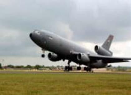
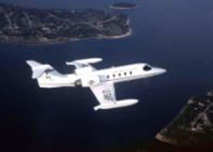

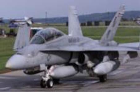
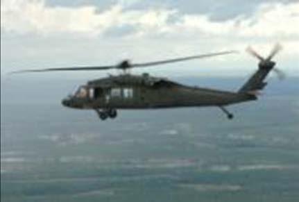
23 Frequently Seen Transient Aircraft F-16 Falcon KC-135 Stratotanker KC-10 Extender C-21 Learjet F/A-18 Hornet UH-60 Blackhawk
Pope Field, NC MID-AIR COLLISION AVOIDANCE
 Pope Field, NC MID-AIR COLLISION AVOIDANCE 2017 43 rd Air Mobility Operations Group Flight Safety, Pope Field, NC Tel: (910)394-8383/ 8389 Fax: (910)394-8098 E-mail:43AMOGW.SE1@US.AF.MIL The potential
APPENDIX F AIRSPACE INFORMATION
 APPENDIX F AIRSPACE INFORMATION Airspace Use DEFINITION OF AIRSPACE Airspace, or that space which lies above a nation and comes under its jurisdiction, is generally viewed as being unlimited. However,
ex) & Comple nce Avoidan 1 August 2010
 & Comple nce Avoidan 1 August 2010") 23 rd Wing, Detachment 1 MacDilll Air Force Base (Deployed Fighter Unit Comple ex) & Avon Park Air Force Range (Restricted Area R-2901) Mid-Air Collision Avoidan nce ( M.A.C. A.) 1 August 2010 Purpose
23 rd Wing, Detachment 1 MacDilll Air Force Base (Deployed Fighter Unit Comple ex) & Avon Park Air Force Range (Restricted Area R-2901) Mid-Air Collision Avoidan nce ( M.A.C. A.) 1 August 2010 Purpose
129 th RQW/SE P.O. Box 103, MS#1 Moffett Federal Airfield, CA
 MID-AIR COLLISION AVOIDANCE (MACA) HANDBOOK 129 th RQW/SE P.O. Box 103, MS#1 Moffett Federal Airfield, CA 94035-0103 129TH RESCUE WING MOFFETT FEDERAL AIRFIELD, CA 1 NOV 2013 TABLE OF CONTENTS FLYING SAFETY
Airspace. Chapter 14. Gold Seal Online Ground School. Introduction
 Gold Seal Online Ground School www.onlinegroundschool.com Chapter 14 Airspace Introduction The two categories of airspace are: regulatory and nonregulatory. Within these two categories there are four types:
Collision Avoidance UPL Safety Seminar 2012
 Collision Avoidance UPL Safety Seminar 2012 Contents Definition Causes of MAC See and avoid Methods to reduce the risk Technologies Definition MID AIR COLLISION A Mid-Air Collision (MAC) is an accident
Class Alpha. In addition, if you fly above FL240 your aircraft must have DME or a suitable RNAV system.
 Go For It Class Alpha Class A airspace is from 18,000 feet MSL to Flight Level 600 (60,000 feet pressure altitude). Its lateral extent includes the contiguous U.S. and Alaska, and extends 12 nm from the
a. Aeronautical charts DID THIS IN LESSON 2
 AIRMAN CERTIFICATION STANDARDS: REMOTE PILOT SMALL: You will know and be able to explain in writing or oral form the below tasks regarding AIRPORT OPERATIONS Task References Objective Task B. Airport Operations
MID-AIR COLLISION AVOIDANCE (MACA) April 2017
 April 2017") S 167th Airlift Wing Eastern WV Regional Airport Shepherd Field (KMRB) Martinsburg, WV MID-AIR COLLISION AVOIDANCE (MACA) April 2017 S 167th AW Flight Safety Office Phone: 304-616-5235 INTRODUCTION The
S 167th Airlift Wing Eastern WV Regional Airport Shepherd Field (KMRB) Martinsburg, WV MID-AIR COLLISION AVOIDANCE (MACA) April 2017 S 167th AW Flight Safety Office Phone: 304-616-5235 INTRODUCTION The
MID-AIR COLLISION AVOIDANCE (MACA)
") 167th Airlift Wing Eastern WV Regional Airport Shepherd Field (KMRB) Martinsburg, WV MID-AIR COLLISION AVOIDANCE (MACA) Always be vigilant of low-flying, fast-moving military aircraft in the red-shaded
167th Airlift Wing Eastern WV Regional Airport Shepherd Field (KMRB) Martinsburg, WV MID-AIR COLLISION AVOIDANCE (MACA) Always be vigilant of low-flying, fast-moving military aircraft in the red-shaded
USE OF RADAR IN THE APPROACH CONTROL SERVICE
 USE OF RADAR IN THE APPROACH CONTROL SERVICE 1. Introduction The indications presented on the ATS surveillance system named radar may be used to perform the aerodrome, approach and en-route control service:
MID-AIR COLLISION AVOIDANCE
 MID-AIR COLLISION AVOIDANCE Information Current As of May 2018 Prepared in the interest of Aviation Safety by the 436 AW Flight Safety Office - Dover AFB, DE Phone: 302-677-2048 Fax: 302-677-2144 E-mail:
92d/141st AIR REFUELING WING SAFETY OFFICE FAIRCHILD AIR FORCE BASE WASHINGTON (509) /7026
 /7026") FREQUENCY REFERENCE GUIDE Fairchild AFB ATIS 257.625 UHF Ground 123.6 Tower 120.35 Spokane Approach 123.75 / 133.35 Spokane International (Geiger Field) ATIS 124.325 CLNC DEL 127.55 Ground 121.9 Tower
FREQUENCY REFERENCE GUIDE Fairchild AFB ATIS 257.625 UHF Ground 123.6 Tower 120.35 Spokane Approach 123.75 / 133.35 Spokane International (Geiger Field) ATIS 124.325 CLNC DEL 127.55 Ground 121.9 Tower
AIRMAN S INFORMATION MANUAL. Enroute
 AIRMAN S INFORMATION MANUAL AIM 52 AIRPORT LIGHTING AND MARKING AIDS Airport Beacons Operation of the airport rotating beacon during the daytime indicates the weather in the Class D airspace is below basic
FLASHCARDS AIRSPACE. Courtesy of the Air Safety Institute, a Division of the AOPA Foundation, and made possible by AOPA Holdings Company.
 AIRSPACE FLASHCARDS Courtesy of the Air Safety Institute, a Division of the AOPA Foundation, and made possible by AOPA Holdings Company. The Air Safety Institute is dedicated to making flying easier and
GENERAL INFORMATION Aircraft #1 Aircraft #2
 GENERAL INFORMATION Identification number: 2007075 Classification: Serious incident Date and time 1 of the 2 August 2007, 10.12 hours occurrence: Location of occurrence: Maastricht control zone Aircraft
MID-AIR COLLISION AVOIDANCE
 62d Airlift Wing McChord Field, Washington MID-AIR COLLISION AVOIDANCE March 2017 62 AW Flight Safety Office, Joint Base Lewis-McChord, McChord Field, Washington Tel: (253) 982-3105 Fax: (253) 982-6553
Contents. Subpart A General 91.1 Purpose... 7
 Contents Rule objective... 3 Extent of consultation... 3 Summary of comments... 4 Examination of comments... 6 Insertion of Amendments... 6 Effective date of rule... 6 Availability of rules... 6 Part 91
NAVIGATION: CHARTS, PUBLICATIONS, FLIGHT COMPUTERS (chapters 7 & 8)
") NAVIGATION: CHARTS, PUBLICATIONS, FLIGHT COMPUTERS (chapters 7 & 8) LONGITUDE AND LATITUDE 1. The location of an airport can be determined by the intersection of lines of latitude and longitude. a. Lines
NAVIGATION: CHARTS, PUBLICATIONS, FLIGHT COMPUTERS (chapters 7 & 8) LONGITUDE AND LATITUDE 1. The location of an airport can be determined by the intersection of lines of latitude and longitude. a. Lines
Class B Airspace. Description
 Class B Airspace Ref. AIM 3-2-3 and FAR 91.131 Surrounds certain large airports Within each Class B airspace area, there are multiple segments with different ceiling/floor altitudes. Example: 70/30 = ceiling
AVIATION INVESTIGATION REPORT A00Q0116 RISK OF COLLISION
 Transportation Safety Board of Canada Bureau de la sécurité des transports du Canada AVIATION INVESTIGATION REPORT A00Q0116 RISK OF COLLISION BETWEEN AIR CANADA AIRBUS INDUSTRIE A319-114 C-FYJB AND CESSNA
Chapter 9 - Airspace: The Wild Blue, Green & Red Yonder
 I5 Class G Airspace 38. [I4/3/3] What minimum visibility and clearance from clouds are required for VFR operations in Class G airspace at 700 feet AGL or lower during daylight hours? A. mile visibility
SCAN TYPES & DEFINITIONS. The GFA has identified three main types of scans, useful for different flight situations. CRUISING SCAN
 SCAN TYPES & DEFINITIONS The GFA has identified three main types of scans, useful for different flight situations. CRUISING SCAN This is a forward conical scan, 60 degrees left and right, and up and down.
60th Air Mobility Wing FAA Sacramento Flight Standards District Office
 MIDAIR COLLISION AVOIDANCE TRAVIS AFB CA March 2011 Contact Information 60th Air Mobility Wing Flight Safety Office (707) 424-1115 Fax (707) 424-1123 Airfield Management (707) 424-0028 Tower Chief (707)
DIRECCION DE PERSONAL AERONAUTICO DPTO. DE INSTRUCCION PREGUNTAS Y OPCIONES POR TEMA
 T E M : 0322 INSTRUTOR_DVNED_07_PROEDURES & IRPT OPS OD_PREG: P R E G U N T : RPT: 6436 n airport without a control tower lies within the controlled airspace of an airport with an operating tower. ccording
PLEASE CALL LAKENHEATH APPROACH CONTROL ON / Within 20 Miles of the CMATZ
 1 MID AIR COLLISION AVOIDANCE Mid-air collision avoidance has increasingly become an important topic within both military and civilian aviation. The purpose of this pamphlet is to provide information about
Fresno Area Mid-Air Collision Avoidance Program (MACA)
") Fresno Area Mid-Air Collision Avoidance Program (MACA) 144 th Fighter Wing California Air National Guard Fresno, CA 1 This pamphlet is courtesy of the 144 th Fighter Wing located at the California Air
Fresno Area Mid-Air Collision Avoidance Program (MACA) 144 th Fighter Wing California Air National Guard Fresno, CA 1 This pamphlet is courtesy of the 144 th Fighter Wing located at the California Air
UNITED STATES OF AMERICA FEDERAL AVIATION ADMINISTRATION WASHINGTON D.C. GRANT OF EXEMPTION
 In the matter of the petition of the DEPARTMENT OF DEFENSE UNITED STATES OF AMERICA FEDERAL AVIATION ADMINISTRATION WASHINGTON D.C. Exemption No. 5100B For an exemption from the provisions 25863 Of sections
Appendix K: MSP Class B Airspace
 Appendix K: MSP Class B Airspace K All of the open sky covering the United States, from less than an inch off the ground all the way to outer space, is part of America s airspace. This airspace resource
II.B. Runway Incursion Avoidance
 References: AC 91-73 Objectives Key Elements Elements Schedule Equipment IP s Actions SP s Actions Completion Standards The student should develop knowledge of the elements related to proper incursion
Accident Prevention Program
 Accident Prevention Program How To Avoid A Mid Air Collision No pilot is invulnerable to an in-flight collision. The most important guard against such mishaps is to know the limitations of the eye and
Operating Safely. A Fundamental Guide to FAA RADAR Operations. Federal Aviation Administration Near Airports
 Operating Safely Near Airports A Fundamental Guide to FAA RADAR Operations Presented to: Pacific Air Soaring Counsel - PASCO By: Donald A. Brooks, Air Traffic Manager Reno TRACON/Tower November 4 th, 2006
CE 563 Airport Design
 CE 563 Airport Design Prevent aircraft collisions Prevent aircraft collisions with obstructions Expedite and maintain an orderly flow of air traffic Air traffic control system command center Herndon, VA
THE VILLAGES AVIATION CLUB. SAFETY BRIEF November 2016
 THE VILLAGES AVIATION CLUB SAFETY BRIEF November 2016 Welcome Back Snowbirds When are you going home? If you see a man wearing a hat like this, go over and say Welcome Home. You ll make his day. Sure,
Pre-Solo Written Exam
 Pre-Solo Written Exam Introduction 14 CFR Part 61.87(b) requires student pilots to demonstrate aeronautical knowledge by completing a knowledge test prior to soloing an aircraft. The test must address
FLIGHT ADVISORY WASHINGTON D.C. SPECIAL FLIGHT RULES AREA LEESBURG MANUVERING AREA
 FLIGHT ADVISORY WASHINGTON D.C. SPECIAL FLIGHT RULES AREA LEESBURG MANUVERING AREA EFFECTIVE October 11, 201609 0400 This Notice does not supersede restrictions pertaining to the use of airspace contained
CAUTION: WAKE TURBULENCE
 CAUTION: WAKE TURBULENCE This was the phrase issued while inbound to land at Boeing Field (BFI) while on a transition training flight. It was early August, late afternoon and the weather was clear, low
DO NOT BEGIN THIS WORK UNTIL YOU HAVE COMPLETED ALL REQUIRED ASSIGNED READING AND EXERCISES.
 DO NOT BEGIN THIS WORK UNTIL YOU HAVE COMPLETED ALL REQUIRED ASSIGNED READING AND EXERCISES. Gardner Textbook Review Questions to prepare for Class #12 Answer these on notebook paper (or a text file) then
WHITEMAN AFB, MO FIELD INFORMATION FIELD LIGHTING NAVIGATIONAL AIDS
 WHITEMAN AFB, MO FIELD INFORMATION FIELD ELEVATION 871 FT RUNWAY 01/19 LENGTH AND WIDTH 12,400 X 200 FIELD LIGHTING High Intensity Runway Lights Precision Approach Path Indicators Sequences Flashing Lights
TRAVIS AIRSPACE. For more information visit the Travis AFB Midair Collision Avoidance (MACA) public website at:
 public website at:") MIDAIR COLLISION AVOIDANCE TRAVIS AFB CA January 2007 TRAVIS AIRSPACE The airspace serviced by Travis Approach Control is used by military aircraft operating in this area, along with IFR and numerous
MIDAIR COLLISION AVOIDANCE TRAVIS AFB CA January 2007 TRAVIS AIRSPACE The airspace serviced by Travis Approach Control is used by military aircraft operating in this area, along with IFR and numerous
UNITED STATES OF AMERICA FEDERAL AVIATION ADMINISTRATION WASHINGTON D.C. GRANT OF EXEMPTION
 In the matter of the petition of the DEPARTMENT OF DEFENSE UNITED STATES OF AMERICA FEDERAL AVIATION ADMINISTRATION WASHINGTON D.C. Exemption No. 5100C For an exemption from the provisions 25863 Of sections
Fresno Area Mid-Air Collision Avoidance Program (MACA) California Air National Guard 144 th Fighter Wing, Fresno, CA
 California Air National Guard 144 th Fighter Wing, Fresno, CA") Fresno Area Mid-Air Collision Avoidance Program (MACA) California Air National Guard 144 th Fighter Wing, Fresno, CA As of March 2013 Mid-Air Collision Avoidance This briefing contains material that can
Fresno Area Mid-Air Collision Avoidance Program (MACA) California Air National Guard 144 th Fighter Wing, Fresno, CA As of March 2013 Mid-Air Collision Avoidance This briefing contains material that can
MID-AIR COLLISION AVOIDANCE AND FLIGHT OPERATIONS AT LITTLE ROCK AIR FORCE BASE AND CAMP ROBINSON
 MID-AIR COLLISION AVOIDANCE AND FLIGHT OPERATIONS AT LITTLE ROCK AIR FORCE BASE AND CAMP ROBINSON LITTLE ROCK AIR FORCE BASE MID-AIR COLLISION AVOIDANCE PROGRAM REVISED: 9 April 2015 *** WARNING *** THE
OPERATIONS MANUAL PART A
 PAGE: 1 Table of Contents A.GENERAL /CHAPTER 32. -...3 32. OF THE AIRBORNE COLLISION AVOIDANCE... 3 32.1 ACAS Training Requirements... 3 32.2 Policy and Procedures for the use of ACAS or TCAS (as applicable)...
THE VILLAGES AVIATION CLUB. November 2014 SAFETY BRIEF
 THE VILLAGES AVIATION CLUB November 2014 SAFETY BRIEF IT WAS DARK, VERY DARK SO LETS GO FLYING SURE, YOU GET AN EXTRA HOURS SLEEP, BUT WHEN DO YOU GO FLYING? REVIEW OF NIGHT FLYING REGS AND TIPS Night
The NOTAM described will replace previously issued FDC NOTAMs 6/2550 and 7/7778 for the DC ADIZ/FRZ.
 This advisory covers published NOTAMs 7/0206 for the DC ADIZ, 7/0211 for the DC FRZ and FDC 7/0204 for the outer speed restriction. WARNING This document only contains an overview of the new rules for
AIR LAW AND ATC PROCEDURES
 1 The International Civil Aviation Organisation (ICAO) establishes: A standards and recommended international practices for contracting member states. B aeronautical standards adopted by all states. C
Chapter 6. Nonradar. Section 1. General DISTANCE
 12/10/15 JO 7110.65W Chapter 6. Nonradar Section 1. General 6 1 1. DISTANCE Use mileage based (DME and/or ATD) procedures and minima only when direct pilot/controller communications are maintained. FIG
MidAir Collision Avoidance (MACA) Program. Luke Air Force Base, Arizona TRAINING THE WORLD S BEST F-35 & F-16 FIGHTER PILOTS!
 Program. Luke Air Force Base, Arizona TRAINING THE WORLD S BEST F-35 & F-16 FIGHTER PILOTS!") MidAir Collision Avoidance (MACA) Program Luke Air Force Base, Arizona TRAINING THE WORLD S BEST F-35 & F-16 FIGHTER PILOTS! JANUARY 2017 Page i Luke AFB - MACA Program Dear Fellow Aviators, Midair collisions
MidAir Collision Avoidance (MACA) Program Luke Air Force Base, Arizona TRAINING THE WORLD S BEST F-35 & F-16 FIGHTER PILOTS! JANUARY 2017 Page i Luke AFB - MACA Program Dear Fellow Aviators, Midair collisions
2012 Mat Su Valley Collision Avoidance Survey
 Table of Contents Table of Contents 1 INTRODUCTION Measurement Objectives 3 Methodology and Notes 4 Key Findings 5 PILOT LOCATION Activity in the Area 7 Pilot Location 8 Altitudes Flown 9 SAFETY IN THE
GACE Flying Club Ground Review Test, 2019 NAME: DATE: SCORE: CORRECTED BY: CFI# DATE:
 GACE Flying Club Ground Review Test, 2019 NAME: DATE: SCORE: CORRECTED BY: CFI# DATE: Circle all correct answer(s), fill in the blanks, or answer true or false. Test to be corrected to 100% by a GACE CFI.
Intro to Small Unmanned Aircraft Systems & Recreational Drones
 Intro to Small Unmanned Aircraft Systems & Recreational Drones Controlled Airspace Controlled Airspace has defined dimensions within which Air Traffic Control (ATC) services are provided. The level of
Pilot RVSM Training Guidance Material
 Pilot RVSM Training Guidance Material Captain Souhaiel DALLEL IFALPA RVP AFI WEST RVSM Pilot Procedures ICAO requires states to establish for flight crews specific: Initial training programs and Recurrent
Gleim Private Pilot Syllabus Fifth Edition, 3rd Printing Updates March 2016
 Page of Gleim Private Pilot Syllabus Fifth Edition, rd Printing Updates March 0 NOTE: Text that should be deleted is displayed with a line through it. New text is shown with a blue background. If you see
Consideration will be given to other methods of compliance which may be presented to the Authority.
 Advisory Circular AC 139-10 Revision 1 Control of Obstacles 27 April 2007 General Civil Aviation Authority advisory circulars (AC) contain information about standards, practices and procedures that the
Public Comment on Condor MOA Proposal
 Public Comment on Condor MOA Proposal Michael Wells, Lt. Colonel (retired) P.O. Box 274 Wilton, ME 04294 20 November, 2009 1. As a retired Air Force Lt. Colonel, squadron commander, F-15 Instructor Pilot,
SECTION 6 - SEPARATION STANDARDS
 SECTION 6 - SEPARATION STANDARDS CHAPTER 1 - PROVISION OF STANDARD SEPARATION 1.1 Standard vertical or horizontal separation shall be provided between: a) All flights in Class A airspace. b) IFR flights
OPERATIONS CIRCULAR 01/2012. Subject: HEAD-UP DISPLAYS (HUD) AND ENHANCED VISION SYSTEMS (EVS)
 AND ENHANCED VISION SYSTEMS (EVS)") GOVERNMENT OF INDIA CIVIL AVIATION DEPARTMENT OFFICE OF THE DIRECTOR GENERAL OF CIVIL AVIATION OPP. SAFDARJUNG AIRPORT, NEW DELHI 110 003 TELEPHONE: 091-011-4635261 4644768 FAX: 091-011-4644764 TELEX:
GOVERNMENT OF INDIA CIVIL AVIATION DEPARTMENT OFFICE OF THE DIRECTOR GENERAL OF CIVIL AVIATION OPP. SAFDARJUNG AIRPORT, NEW DELHI 110 003 TELEPHONE: 091-011-4635261 4644768 FAX: 091-011-4644764 TELEX:
Appendix B. Comparative Risk Assessment Form
 Appendix B Comparative Risk Assessment Form B-1 SEC TRACKING No: This is the number assigned CRA Title: Title as assigned by the FAA SEC to the CRA by the FAA System Engineering Council (SEC) SYSTEM: This
helicopter? Fixed wing 4p58 HINDSIGHT SITUATIONAL EXAMPLE
 HINDSIGHT SITUATIONAL EXAMPLE Fixed wing or helicopter? Editorial note: Situational examples are based on the experience of the authors and do not represent either a particular historical event or a full
EXAMPLE RADIO SCRIPTS. Fly Safe! Flight Following Wichita Approach, this is, checking in at,
 EXAMPLE RADIO SCRIPTS Wichita Approach Control offers flight following, wind & altimeter readings and practice approaches for VFR aircraft. The following scripts may prove helpful when requesting services.
Mid-Air Collision Avoidance
 4th Fighter Wing Seymour Johnson AFB, NC Mid-Air Collision Avoidance Published By 4th Fighter Wing Flight Safety Seymour Johnson AFB, NC (919) 722-4227 www.seeandavoid.org Airfield Identifier: GSB If you
- ORM Review - When to use ORM - Online ORM form usage - Common mistakes - Icing, The regs and You
 - ORM Review - When to use ORM - Online ORM form usage - Common mistakes - Icing, The regs and You The Six Steps of the ORM Process 1. Identify the hazards 2. Assess the risks 3. Analyze the risk control
MIDAIR COLLISION AVOIDANCE (MACA)
") MARCH AIR RESERVE BASE MARCHPAMPHLET91-202-MACA MIDAIR COLLISION AVOIDANCE (MACA) PILOT CONTROLLER LIAISON PAMPHLET MARCH AIR RESERVE BASE CALIFORNIA MARCHPAMPHLET91-202-MACA DATE: 14 May 2015 OPR: 452
MARCH AIR RESERVE BASE MARCHPAMPHLET91-202-MACA MIDAIR COLLISION AVOIDANCE (MACA) PILOT CONTROLLER LIAISON PAMPHLET MARCH AIR RESERVE BASE CALIFORNIA MARCHPAMPHLET91-202-MACA DATE: 14 May 2015 OPR: 452
MEMORANDUM FOR ALASKA AVIATORS 21 Apr 2016
 21 April 2016 MEMORANDUM FOR ALASKA AVIATORS 21 Apr 2016 FROM: 354 FW/SEF 354 Broadway Ave Unit 14A Eielson AFB AK 99702-1899 SUBJECT: Military Flying in Interior Alaska 1. This pamphlet is offered to
Safety Syllabus. VFR into IMC
 VFR into IMC A syllabus designed to help protect pilots against GA's most fatal type of weather-related accident: VFR into IMC. Recommended for use by flight instructors and schools. 2017 421 Aviation
AOPA Air Safety Foundation
 S A F E T Y A D V I S O R Operations and Proficiency No. 9 Lights-Out A New Collision Avoidance Challenge See and Avoid Part 91 states that when weather conditions permit, both IFR and VFR aircraft must
Safety Brief. 21st March Operations in Somali Airspace
 Safety Brief 21st March 2017 Operations in Somali Airspace Background IATA is aware of safety reports detailing various high risk events related to operations within the Mogadishu (Somalia) FIR (HCSM).
RADIO COMMUNICATIONS AND ATC LIGHT SIGNALS
 RADIO COMMUICATIOS AD ATC LIGHT SIGALS VI - A ITRODUCTIO RADIO LICESE RADIO EQUIPMET PHRASEOLOGY LOST COMMUICATIO Receiver Transmitter Both Departure - Operating in and out of a controlled airport, as
BFR WRITTEN TEST B - For IFR Pilots
 (61 Questions) (Review and study of the FARs noted in parentheses right after the question number is encouraged. This is an open book test!) 1. (91.3) Who is responsible for determining that the altimeter
EASA NPA on SERA Part ENAV Response sheet. GENERAL COMMENTS ON NPA PACKAGE Note: Specific comments are provided after the General Comments
 EASA NPA on SERA Part ENAV Response sheet GENERAL COMMENTS ON NPA PACKAGE te: Specific comments are provided after the General Comments 1 SERA Parts C and D ENAV still misses clarity on the whole scope
COMPLIANCE WITH THIS PUBLICATION IS MANDATORY
 BY ORDER OF THE SECRETARY OF THE AIR FORCE AIR FORCE MANUAL 13-215 VOLUME 1 11 FEBRUARY 2019 Nuclear, Space, Missile, Command, and Control AIRFIELD OPERATIONS DATA SYSTEMS COMPLIANCE WITH THIS PUBLICATION
FAA FORM UAS COA Attachment FAA
 Page 1 of 6 DEPARTMENT OF TRANSPORTATION FEDERAL AVIATION ADMINISTRATION CERTIFICATE OF WAIVER OR AUTHORIZATION ISSUED TO Xcam Aerials, Inc. 10197 SE 144th Place Summerfield, FL 34491 This certificate
Air Law. Iain Darby NAPC/PH-NSIL IAEA. International Atomic Energy Agency
 Air Law Iain Darby NAPC/PH-NSIL International Atomic Energy Agency Aviation Regulations International Civil Aviation Organisation (ICAO) Convention on International Civil Aviation also known as the Chicago
FLIGHT ADVISORY NATIONAL SPECIAL SECURITY EVENT UNITED NATIONS GENERAL ASSEMBLY UNGA-67 SEPTEMBER 18, 2012 September 28, 2012
 FEDERAL AVIATION ADMINISTRATION FLIGHT ADVISORY NATIONAL SPECIAL SECURITY EVENT UNITED NATIONS GENERAL ASSEMBLY UNGA-67 SEPTEMBER 18, 2012 September 28, 2012 This advisory will serve as notice of flight
1.1.3 Taxiways. Figure 1-15: Taxiway Data. DRAFT Inventory TYPICAL PAVEMENT CROSS-SECTION LIGHTING TYPE LENGTH (FEET) WIDTH (FEET) LIGHTING CONDITION
 WIDTH (FEET) LIGHTING CONDITION") 1.1.3 Taxiways EWN has an extensive network of taxiways and taxilanes connecting the terminal, air cargo, and general aviation areas with the runways as listed in Figure 1-15. A 50-foot wide parallel taxiway
1.1.3 Taxiways EWN has an extensive network of taxiways and taxilanes connecting the terminal, air cargo, and general aviation areas with the runways as listed in Figure 1-15. A 50-foot wide parallel taxiway
TRAFFIC ALERT AND COLLISION AVOIDANCE SYSTEM (TCAS II)
") TRAFFIC ALERT AND COLLISION AVOIDANCE SYSTEM (TCAS II) Version 1.0 Effective June 2004 CASADOC 205 Traffic Alert and Collision Avoidance System (TCAS II) This is an internal CASA document. It contains
TRAFFIC ALERT AND COLLISION AVOIDANCE SYSTEM (TCAS II) Version 1.0 Effective June 2004 CASADOC 205 Traffic Alert and Collision Avoidance System (TCAS II) This is an internal CASA document. It contains
AIRPROX REPORT No Date/Time: 27 Aug Z. (5nm NE Coventry Airport) Airspace: London FIR (Class: G)
 Airspace: London FIR (Class: G)") AIRPROX REPORT No 2013123 Date/Time: 27 Aug 2013 1452Z Position: 5225N 00122W (5nm NE Coventry Airport) Airspace: London FIR (Class: G) Reporting Ac Type: ATP C172 Reported Ac Operator: CAT Civ Pte Alt/FL:
AIRPROX REPORT No 2013123 Date/Time: 27 Aug 2013 1452Z Position: 5225N 00122W (5nm NE Coventry Airport) Airspace: London FIR (Class: G) Reporting Ac Type: ATP C172 Reported Ac Operator: CAT Civ Pte Alt/FL:
LETTER OF AGREEMENT (LOA)
") LETTER OF AGREEMENT (LOA) East Hampton Airport (revision 1) EFFECTIVE: July 16, 2012 SUBJECT: VISUAL FLIGHT RULES (VFR)/SPECIAL VFR (SVFR) HELICOPTER OPERATIONS TO/FROM EAST HAMPTON AIRPORT 1) PURPOSE:
LETTER OF AGREEMENT (LOA) East Hampton Airport (revision 1) EFFECTIVE: July 16, 2012 SUBJECT: VISUAL FLIGHT RULES (VFR)/SPECIAL VFR (SVFR) HELICOPTER OPERATIONS TO/FROM EAST HAMPTON AIRPORT 1) PURPOSE:
Unmanned Aircraft Operations in the National Airspace System. AGENCY: Federal Aviation Administration (FAA), DOT.
, DOT.") [4910-13] DEPARTMENT OF TRANSPORTATION Federal Aviation Administration 14 CFR Part 91 Docket No. FAA-2006-25714 Unmanned Aircraft Operations in the National Airspace System AGENCY: Federal Aviation Administration
[4910-13] DEPARTMENT OF TRANSPORTATION Federal Aviation Administration 14 CFR Part 91 Docket No. FAA-2006-25714 Unmanned Aircraft Operations in the National Airspace System AGENCY: Federal Aviation Administration
Glossary. Part I Acronyms/Data Terminology. AIFSS -- Automated International Flight Service Station.
 Glossary Part I Acronyms/Data Terminology AC -- Air Carrier. AFSS -- Automated Flight Service Station. AIFSS -- Automated International Flight Service Station. ARTCC -- Air Route Traffic Control Center.
PRESOLO WRITTEN EXAM
 PRESOLO WRITTEN EXAM Date of Exam STUDENT INFORMATION Student Name Student Pilot Certificate Number FLIGHT INSTRUCTOR INFORMATION Instructor Instructor Certificate Number 1 INTRODUCTION Student Actions:
Crew Resource Management
 Crew Resource Management Crew (or Cockpit) Resource Management (CRM) training originated from a NASA workshop in 1979 that focused on improving air safety. The NASA research presented at this meeting found
VANCE AIR FORCE BASE MIDAIR COLLISION AVOIDANCE (MACA) LET S NOT MEET BY ACCIDENT!
 LET S NOT MEET BY ACCIDENT!") VANCE AIR FORCE BASE MIDAIR COLLISION AVOIDANCE (MACA) LET S NOT MEET BY ACCIDENT! Fel!ow Aviators, Midair collisions are an area of vital concern to everyone who flies an airplane. Historically, the number
VANCE AIR FORCE BASE MIDAIR COLLISION AVOIDANCE (MACA) LET S NOT MEET BY ACCIDENT! Fel!ow Aviators, Midair collisions are an area of vital concern to everyone who flies an airplane. Historically, the number
AIRSPACE MANAGEMENT AND COMMUNICATION
 STATE OF FLORIDA D I V I S I O N O F E M E R G E N C Y M A N A G E M E N T RICK SCOTT Governor BRYAN W. KOON Director Approved: SERT Air Operations Branch Document: IRMA Airspace Plan 1.0 Effective: September
Albuquerque Aerostat Ascension Association
 Attachment C Albuquerque Aerostat Ascension Association Balloon Flight Operations Manual AAAA Flying Events AAAA Balloon Flight Operations Manual Table of Contents This manual has been prepared as part
Using The Approach Planner
 Using The Approach Planner photo Living With Your Plane For airports and airfields without published procedures (All graphics in this tutorial are for illustration purposes only and not for flying) A Product
CHAPTER 5 SEPARATION METHODS AND MINIMA
 CHAPTER 5 SEPARATION METHODS AND MINIMA 5.1 Provision for the separation of controlled traffic 5.1.1 Vertical or horizontal separation shall be provided: a) between IFR flights in Class D and E airspaces
Date: 29 Apr 2017 Time: 1119Z Position: 5226N 00112W Location: 10nm ENE Coventry
 AIRPROX REPORT No 2017080 Date: 29 Apr 2017 Time: 1119Z Position: 5226N 00112W Location: 10nm ENE Coventry PART A: SUMMARY OF INFORMATION REPORTED TO UKAB Recorded Aircraft 1 Aircraft 2 Aircraft C560 PA28
Chapter The All-new, World-class Denver International Airport Identify Describe Know Describe Describe
 Chapter 10 The aerospace subject is very large and diverse. As seen in previous chapters, there are many subject areas. So far you have learned about history, weather, space and aerodynamics. Now you will
CFIT-Procedure Design Considerations. Use of VNAV on Conventional. Non-Precision Approach Procedures
 OCP-WG-WP 4.18 OBSTACLE CLEARANCE PANEL WORKING GROUP AS A WHOLE MEETING ST. PETERSBURG, RUSSIA 10-20 SEPTEMBER 1996 Agenda Item 4: PANS-OPS Implementation CFIT-Procedure Design Considerations Use of VNAV
NOISE ABATEMENT PROCEDURES
 1. Introduction NOISE ABATEMENT PROCEDURES Many airports today impose restrictions on aircraft movements. These include: Curfew time Maximum permitted noise levels Noise surcharges Engine run up restrictions
Effective Altitude. R-3103 To 30,000 (To 9,144 meters) Source: NACO 2002 Notes: 1 By NOTAM issued 12 hours in advance
 Source: NACO 2002 Notes: 1 By NOTAM issued 12 hours in advance") 8.4 AIRSPACE USE 8.4.1 Affected Environment The affected airspace environment is described below in terms of its principal attributes, namely controlled and uncontrolled airspace, special use airspace,
8.4 AIRSPACE USE 8.4.1 Affected Environment The affected airspace environment is described below in terms of its principal attributes, namely controlled and uncontrolled airspace, special use airspace,
4.2 AIRSPACE. 4.2 Airspace. Supplemental Draft Environmental Impact Statement August 2008 Military Training Activities at Mākua Military Reservation
 4.2 AIRSPACE 4.2.1 Impact Methodology Impacts on airspace use were assessed by evaluating the potential effects of the proposed training activities on the principal attributes of airspace use, as described
Date: 01 Aug 2016 Time: 1344Z Position: 5441N 00241W
 AIRPROX REPORT No 2016157 Date: 01 Aug 2016 Time: 1344Z Position: 5441N 00241W Location: Langwathby PART A: SUMMARY OF INFORMATION REPORTED TO UKAB Recorded Aircraft 1 Aircraft 2 Aircraft AS365 King Air
UAS Pilot Course. Lesson 5 Study Guide- Operations. Questions taken from ASA Remote Pilot Test Prep Guide
 Lesson 5 Study Guide- Operations 1. During the preflight inspection who is responsible for determining the aircraft is safe for flight? a. The remote pilot in command b. The owner or operator c. The certificated
The following criteria shall be applied within the boundaries of the AO District:
 Sec. 419 (a) Purpose AIRPORT OVERLAY DISTRICT (AO) The purpose of the Airport Overlay District is to regulate and restrict the height of structures, objects, or natural growth, regulate the locations of
FLYING IN THE WASHINGTON, DC. SFRA/FRZ Open Sky Aviation, LLC
 FLYING IN THE WASHINGTON, DC. SFRA/FRZ 2014 Open Sky Aviation, LLC SFRA What Is It? Pronounced sifra or S-F-R-A Defined by 14 CFR Part 93 Subpart V Washington, DC Metropolitan Area Special Flight Rules
Table 5-15 Special Use Airspace in the SBMR Airspace ROI
 5.4 AIRSPACE 5.4.1 Affected Environment The affected airspace environment is described below in terms of its principal attributes, namely controlled and uncontrolled airspace, special use airspace, military
IFR SEPARATION WITHOUT RADAR
 1. Introduction IFR SEPARATION WITHOUT RADAR When flying IFR inside controlled airspace, air traffic controllers either providing a service to an aircraft under their control or to another controller s