MEMORANDUM FOR ALASKA AVIATORS 21 Apr 2016
|
|
|
- Kellie Blake
- 6 years ago
- Views:
Transcription

1 21 April 2016
2 MEMORANDUM FOR ALASKA AVIATORS 21 Apr 2016 FROM: 354 FW/SEF 354 Broadway Ave Unit 14A Eielson AFB AK SUBJECT: Military Flying in Interior Alaska 1. This pamphlet is offered to give you a working knowledge of the military airspace used in interior Alaska. This airspace is shared with the military, flying businesses, and civilians who fly for pleasure. The information in this pamphlet is focused toward reducing the risk of a mid-air collision between civil and military aviators. 2. Some pilots refer to the Big Sky theory of air traffic control. This method of air traffic control is based upon two conditions: 1) lots of airspace, and 2) very few airplanes. Although the Alaskan skies are spacious, the Big Sky method of mid-air collision avoidance is risky at best, and unreasonable in the Fairbanks flying area. 3. There are 13 active airfields, two glider ports, and two seaplane ports within six miles of the three airfields with separate Class D airspaces in and around Fairbanks. Nearly every type of aircraft that flies in the United States can be seen in these skies including helicopters, light planes, jumbo jets, float planes, fighters, tankers, military drones, and many other transient aircraft. This diversity brings with it a high potential for traffic conflicts. 4. In this environment a pilot using knowledge, good visual and radio lookout, and help from ground-based radar is much better off than the pilot using the Big Sky method. Good pilots know the location of all high density traffic areas, and the general flight characteristics of the primary types of aircraft operating in these areas. Knowing the location and restrictions (if any) is beneficial to all pilots. The smart pilot is not averse to requesting radar advisories whenever possible. Special Use Airspace Information Service (SUAIS) is available 24 hours a day and can be a great aid to pilots flying in Alaska. This pamphlet will discuss SUAIS and its use along with other information you can use to avoid a near miss or a mid-air collision. Remember... flying safety is no accident. 5. If you have any questions about military flying at Eielson Air Force Base, or any of our military operating areas, please call the Eielson Flight Safety Office at //Signed// KENDALL W. SPENCER, Maj, USAF Acting Chief of Safety 2
3 TOPIC Military Aircraft 4 Ladd Army Airfield 5 Eielson s Class D Airspace 6 Special Use Air Space Information Service (SUAIS) 9 Special Use Airspace Depiction 10 Flying in the Eielson AFB Area 10 Exercise Schedule 10 Training Areas and Low Level Routes 12 Lights Out Operations at Night 13 Wake Turbulence 13 Reporting Conflicts with Military Aircraft 13 PAGE Important 2016 Updates PAGE Ladd Army Airfield 5 Eielson Fixed Wing Approach/Departure Traffic explanations /17 Major Exercise Schedule 10 3
. These fighters carry an onboard radar that can detect other aircraft at great distances beyond visual range.")
 and fly at high speed (normal operating speeds at low level = 400 to 550 KTS), which can make them difficult to see.")

 operate in and around Alaska s interior.")
4 MILTARY AIRCRAFT FIGHTERS F-16s, F-22s, F-18s and other ally fighters frequently fly in the Interior Military Operating Areas (MOA) airspace as well as Restricted Areas R-2202, R-2205, and R-2211 and military training routes (MTR). These fighters carry an onboard radar that can detect other aircraft at great distances beyond visual range. This enhances the pilot s ability to see and avoid other aircraft, but this technology does not allow the pilot to detect all aircraft. These fighters are small in size (wing span=33-45 feet) and fly at high speed (normal operating speeds at low level = 400 to 550 KTS), which can make them difficult to see. AIRLIFT KC-135s, C-17s, C-130s, KC-10s, and other ally airlift aircraft frequently fly in the interior MOAs as well as MTRs. C-130s frequently fly at feet and often in groups of 2-6 aircraft with ½ to 1 mile separation. C-17s also frequently fly at 500 feet on the MTRs and in the MOAs. When navigating point to point outside of the MTRs airlift aircraft normally operate between 100 and 250 knots when below 10,000 feet. HELICOPTERS Multiple variants of military helicopters (HH/UH-60 Pave/Black Hawk, CH-47 Chinook, AH-64 Apache, etc.) operate in and around Alaska s interior. They operate primarily from Fort Wainwright (Ladd Army Airfield east of Fairbanks) and Fort Greeley (Allen Army Airfield north of Delta Junction). Aircraft operating from Fort Wainwright transit to and operate in R (east of Eielson) and will work south of the Tanana River in training areas located in the Tanana Flats south of Fairbanks. Aircraft operating from Fort Greeley commonly transit west of the Delta River and operate south of the Tanana River in the vicinity of R Army helicopter operations in these areas are generally below 1000 feet AGL. 4

 RP Nordale- Bi-directional (Outbound 1500 ) (Inbound 1800 ) IP Salchaket Inbound 1200 RP River")
5 Unmanned Aerial Systems (UAS) UAS are operated between 3000 and 3500 feet MSL and are accompanied by a chase helicopter. The UAS is under positive control through Fairbanks Approach or Ladd Tower and will alter course to avoid collision, however we request that all civil aircraft remain a minimum of 1000ft clear. UAV TRANSIT COORIDOR* ( Green Route ) MSL (Red Line) MSL (Purple line) *Check Ladd AAF (PAFB) NOTAMs for updates (Contact Fairbanks Approach for traffic advisories) LADD ARMY AIRFIELD Helicopter Maintenance Test Flight Area (Contact Fairbanks Approach for traffic advisories) RP Nordale- Bi-directional (Outbound 1500 ) (Inbound 1800 ) IP Salchaket Inbound 1200 RP River Outbound 1200 Ladd Entry/Exit (Initial/Reporting Points) and Special Use Areas The Ladd Maintenance Test Flight Area is the location where US Army Helicopters conduct necessary flight check maneuvers for maintenance verification. Helicopters operating in this area are generally in contact with either Ladd Tower or Fairbanks Approach. VFR traffic should exercise caution in this area as some maintenance maneuvers require multiple turns, climbs, and descents. 5
6 EIELSON S CLASS D AIRSPACE Eielson Class D Airspace: Defined as the airspace extending upward from the surface to and including 3,000 feet MSL within a 4.7 NM radius of Eielson AFB. Unless otherwise authorized, each person must establish two-way radio communications with the ATC facility providing air traffic services prior to entering the airspace and thereafter maintain those communications while in the airspace. No separation services are provided to VFR aircraft. The control tower is operational daily from local time and other times by NOTAM. Eielson tower must be contacted if operating in the Class D Airspace. Frequencies are and NOTE: There is a long stretch of the Tanana River that lies well within the 4.7NM radius of the Class D Airspace. Also take note that Eielson TACAN lies at the south end of the 14,530-foot runway (That s almost three miles!). As such, when traversing the Eielson Class D Air space, it is advisable not to use just the river or TACAN (DME) as a guide to five miles, instead remain well clear to the west of the river and always contact the tower if able. Class D Airspace From surface up to and including Nautical Miles LOCATION RUNWAY 32/14 ELEVATION LIGHTING RUNWAY EIELSON AFB AIRFIELD INFORMATION NAVAIDS TACAN-CH 98 Runway 32 ILS Runway 14 ILS RADAR CLASS D AIRSPACE FREQUENCIES SUAIS 22 miles east of Fairbanks, Alaska 14,530 feet, concrete, two north arresting cables, one south arresting cable 547 feet MSL Airfield Rotating Beacon (1 Green, 2 White) High Intensity Runway Lighting (HIRL) with Sequenced Flashing, Precision Approach Path Indicator (PAPI) No radar approaches at this time 4.7 nm radius up to 3,000 feet MSL TOWER (VHF) OR (UHF) GROUND (VHF) OR (UHF) EIELSON RANGE CONTROL (VHF) (or from Fairbanks area) 6
7 EIELSON AFB AIR TRAFFIC CONTROL CONTACTS Commander, Airfield Operations Flight (907) Chief Controller, Tower (907) Chief, ATC Training Standardization (907) EIELSON FIXED WING APPROACH/DEPARTURE TRAFFIC AREAS Military aircraft flying visual and instrument approaches to Eielson AFB fly in defined patterns depending upon the weather and mission requirements. It is advisable for all aircraft working within 25 miles of Eielson to contact Fairbanks Approach on VHF for Air Traffic Control advisories and services. If pilots do not desire or are unable to contact Fairbanks Approach it is recommended they fly their aircraft 500 feet below the following altitudes to remain clear of high traffic fixed wing approach and departure corridors servicing Eielson AFB (Note: These recommendations do not ensure clearance from helicopters and some fixed wing aircraft that arrive and depart Eielson at low altitudes from time to time): feet MSL when operating outside Eielson s Class D Airspace, but within 15 NM of Eielson feet MSL NM from Eielson feet MSL NM from Eielson SEE MAP ON NEXT PAGE 7
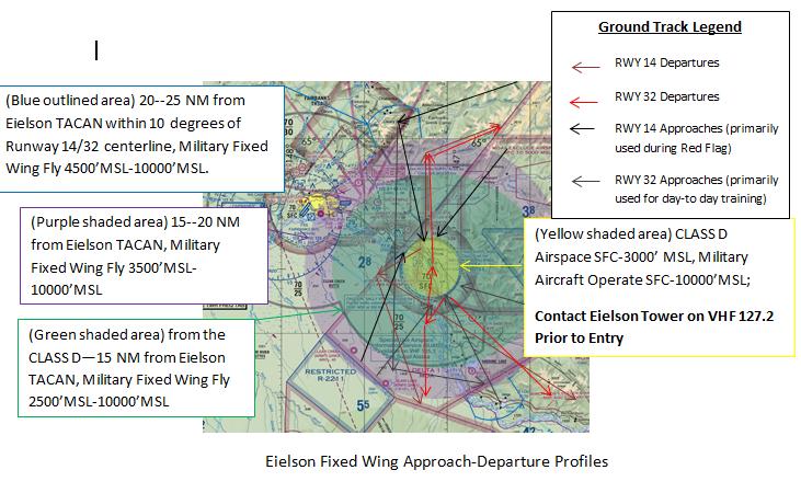
8 8
9 SPECIAL USE AIRSPACE INFORMATION SERVICE What is it? SUAIS is a 24-hour service provided to civilian pilots flying in and around MOAs and Restricted Areas in Interior Alaska. Pilots can call SUAIS at Restricted Joint Use- USAF ( ), from the Fairbanks area, or VHF 125.3, call sign Eielson Range Control. Primary coverage is along the Richardson and Alaska Highways. The further from the highway, typically the coverage quality is reduced. SUAIS information is available at: then select "Special Use Airspace Information Service (SUAIS) Pamphlet" found under "Flying in Alaska" Who is Eielson Range Control (ERC)? ERC is an airspace facilitator at Eielson AFB, Alaska. It is normally staffed from 9 a.m. to 7 p.m., Monday through Friday (except federal holidays), and times when Air Force flying is in progress in Interior Alaskan MOAs and Restricted Areas. After hours, telephone and radio callers will hear the airspace status through a recorded message. ERC is equipped with UHF and VHF radios and radar displays. WHY USE SUAIS? SAFETY: Eielson Range Control monitors all military activity in MOAs and can advise civilian pilots of high-speed military aircraft operating in them. The MOAs adjacent to the Richardson and ALCAN Highways between Tok, Delta Junction, and Fairbanks are areas of heavy general aviation use. MOA exclusion areas have been established along the highways. The MOAs are of special concern since they are subject to flights at high speed/low altitude by military aircraft. EFFICIENCY: Military Restricted Areas are not always in use. Eielson Range Control can advise civilian aircraft of current restricted area status. EMERGENCY: Eielson Range Control can assist in clearing military aircraft out of this airspace if requested by the FAA or other agencies for emergency operations such as air ambulance missions or fire fighting operations. SUAIS RADIO AND RADAR COVERAGE Radio relay stations permit pilots flying as low as a few hundred feet to contact Eielson Range Control in the Tanana Valley between Lake George and Fairbanks. Aircraft flying in mountainous terrain to the east of the Tanana River will need to be as high as the tops of the highest terrain in their immediate vicinity. The general area of radio coverage encompasses Circle to the north, Fairbanks to the west, Black Rapids to the south, and Chicken to the east. The ability to detect light aircraft without transponders is limited. Transponder use is highly recommended. Eielson Range Control does not provide air traffic control services. They can provide information on the status of airspace and the approximate locations of military aircraft in the area. IFR vectoring, processing of flight plans, etc., is not provided. Use of the SUAIS constitutes an acknowledgment, understanding, and acceptance of these limitations. Does SUAIS include current Army operations? SUAIS includes Army artillery firing at all hours, and known helicopter operations. It also provides Army Unmanned Aerial Vehicle operations information in their area of coverage between Donnelly Dome and Fairbanks. 9

10 History. The Air Force created SUAIS in 1994 to enhance both safety and efficient airspace use in Interior Alaska. Since then, it has become a regular feature of general and commercial aviation in the area. For more information log on to the following Web site: SPECIAL USE AIRSPACE Birch MOA Exclusion Area: Delta MOA: Active during RF-A periods ( ; M-F) during exercises. Use extreme caution. See below for dates BIRCH MOA Exclusion Area Alaska Hwy MOA Exclusion Area Richardson Hwy MOA Exclusion Area FLYING IN THE EIELSON AFB AREA Awareness of Military Operating Areas (MOAs), Military Training Routes (MTRs), and Restricted Areas is essential to safe flying. Red Flag Alaska exercises bring large numbers of military aircraft to operate in these areas. Eielson AFB aircraft use three bombing (and artillery) ranges (R-2202, R-2205, and R-2211). These ranges are clearly depicted on sectional charts. It is essential that civilian aircraft avoid flying in these ranges when they are in use, particularly during Red Flag exercises. The projected Red Flag schedule (with airspace times) is listed below. Check for updates at RED FLAG-Alaska 16-1 RED FLAG-Alaska 16-2 RED FLAG-Alaska 16-3 RED FLAG-Alaska Apr-13 May 2016 ( ; M-F) 3-17 Jun 2016 ( ; M-F) 5-19 Aug 2016 ( ; M-F) 7-21 Oct 2016 ( ; M-F) 10
11 Aircraft involved with these exercises will be taking off from Eielson and Elmendorf AFBs, operating in the airspaces depicted above at 500 AGL MSL, and returning to Eielson and Elmendorf. Some aircraft are authorized to fly to 100 AGL in the Eielson and Yukon MOAs, Restricted areas, and Military Training Routes. Contact Eielson Range Control on MHz (SUAIS) to determine if the ranges, MTRs, and MOAs are in use, and to obtain clearance through the ranges when conditions permit. There are no FAA controlling agencies that civilian aircraft can contact for traffic advisories when the MOAs are active. While Eielson range control may help, diligent visual lookout must be practiced when flying through active MOAs. Aircraft from Eielson AFB and Elmendorf AFB also use low altitude Military Training Routes. These routes, both VR and IR, are depicted on sectional charts; however, only the route centerline is shown (almost all Alaskan routes are 10nm wide). Generally these routes extend from the surface to 3000 feet AGL; but some go as high as 17,000 MSL. Eielson Range Control can tell you if an MTR in the Eielson area is active. Fairbanks Flight Service Stations (FSS) is another source to tell you which routes are active within 100NM. Generally, fighter aircraft flying on MTRs are low altitude and high speed. It is best to avoid active MTRs if at all possible. DO: Plan ahead and become familiar with the Alaskan Military Operating Areas and Restricted Airspace. Call SUAIS prior to flight at or Ensure your windscreen is clean and practice good visual scanning techniques. Listen to your radio and obey basic flying rules. Contact Eielson Range Control for SUAIS in the vicinity of Eielson AFB, Interior ranges or MOAs. Avoid flying through active MOAs and MTRs, whenever possible. If Eielson Range Control is not available, contact nearest FSS or Fairbanks Approach to determine if ranges, MOAs, or MTRs are active. When flying through active MOAs or MTRs maintain a constant visual lookout (ahead and behind) for military traffic. DON T: EVER fly through an active restricted area without contacting Eielson Range Control on for permission. Live bombing, artillery, or surface to air missile firings may be in progress. Position reports made on this frequency may be heard even if you do not receive a response. Fly through active Military Airspace unless it is impractical to go around it. 11
. A projected Red Flag exercise schedule can be found at: http://www.")
12 TRAINING AREAS AND LOW LEVEL ROUTES SPECIAL CONSIDERATIONS FOR RED FLAG ALASKA EXERCISES Red Flag Alaska is a series of large scale flying exercises, which occur in the Eielson AFB area several times a year. These exercises may have up to 100 military aircraft flying in the Eielson AFB area at one time (in the span of two hours). A projected Red Flag exercise schedule can be found at: or in the Flying in the Eielson AFB Area section of this pamphlet. These aircraft normally depart Eielson using Runway 32 and recover using Runway 14. It is HIGHLY RECOMMENDED that operating east of Fairbanks and in the vicinity of North Pole during these exercises comply with the procedures outlined in the Eielson Fixed Wing Approach/Departure Traffic Areas Section of this pamphlet. It is very hazardous to fly VFR within the Interior Military Operations Areas during Red Flag Alaska exercise periods. These periods are usually three hours long; normally one period is in the morning and one in the afternoon. Fairbanks FSS, Fairbanks Approach, or Eielson Range Control (VHF 125.3, , or ) can confirm these exercise periods. Civilian aircraft flying from Northway or Glennallen to Fairbanks can avoid Red Flag Alaska airspace by flying in the VFR corridors beneath the Buffalo and Birch MOAs. You are encouraged to participate in the Special Use Airspace Information Service (SUAIS) provided by 12
13 Eielson Range Control when airborne. This service is described above and also in pamphlets obtained at any Flight Service Station in the interior or on the web page. LIGHTS OUT OPERATIONS AT NIGHT Military operations now require pilots to train with Night Vision Goggles (NVGs). This training involves flying with reduced aircraft lighting and in some cases no exterior lights at all. At times pilots practice NVG takeoffs and landings which require Eielson AFB airfield lighting to be turned down or even off. A NOTAM will be posted listing times, Restricted Airspace, and/or MOAs being used. Pilots relying only on See and Avoid will not be able to see these aircraft, nor in some cases the airfield--and should avoid the area or coordinate with the controlling agency in order to ensure positive separation. Safety procedures are in place using radar to ensure that military aircrews know when VFR aircraft enter the airspace. If necessary, they will turn their lights on and stop training if an unsafe situation develops. WAKE TURBULENCE Dangerous? YES! Unexpected, invisible, and unpredictable? NO! The one positive aspect of wake turbulence is its predictable occurrence. Wake turbulence is a vortex created by any wing producing lift. The vortex trails the wing tips and spreads outwards and downwards at 500 feet per minute. All aircraft produce some degree of wake turbulence, however, the greater the generating aircraft weight and the slower it flies, the more powerful the vortices. Cargo aircraft and passenger airliners produce powerful wake turbulence that could have a dramatic effect on the unsuspecting general aviation pilot. Reference AIM for a complete discussion of wake turbulence. Here are some good rules of thumb for avoiding wake turbulence. During cruise, avoid flying directly behind and below other aircraft. During landing, stay at or above the larger aircraft s final approach flight path note its touchdown point and land beyond it; during takeoff, liftoff before the rotation point of the heavy aircraft and climb above its flight path. Allow adequate time separation between yourself and the aircraft in front of you, even if traveling perpendicular to its flight path. Don t get caught in these horizontal tornadoes...think Ahead! REPORTING CONFLICTS WITH MILITARY AIRCRAFT Near Midair Collision Avoidance Reporting 1. Purpose and Data Uses. The primary purpose of the Near Mid-Air Collision (NMAC) Reporting Program is to provide information for use in enhancing the safety and efficiency of the National Airspace System. Data obtained from NMAC reports are used by the FAA to improve the quality of FAA services to users and to develop programs, policies, and procedures aimed at the reduction of NMAC occurrences. All NMAC reports are thoroughly investigated by Flight Standards Facilities in coordination with Air Traffic Facilities. Data from these investigations are transmitted to FAA Headquarters in Washington, DC, where they are compiled and analyzed, and where safety programs and recommendations are developed. 2. Definition. An NMAC is defined as an incident associated with an aircraft in which a possibility of collision exists as a result of proximity of less than 500 feet to another aircraft, or a 13
14 report is received from a pilot or a flight crew member stating a collision hazard existed between two or more aircraft. 3. Reporting Responsibility. It is the responsibility of the pilot and/or flight crew to determine whether an NMAC did actually occur and, if so, to initiate a NMAC report. Be specific, as ATC will not interpret a casual remark to mean that a NMAC is being reported. The pilot should state: "I wish to report a near mid-air collision." 4. Where to File Reports. Pilots and/or flight crew members involved in NMAC occurrences are urged to report each incident immediately: a) By radio or telephone to the nearest FAA ATC facility or FSS or, b) In writing to the nearest Flight Standards District Office (FSDO). 5. Items to be Reported. a) Date and time (UTC) of incident. b) Location of incident and altitude. c) Identification and type of reporting aircraft, aircrew destination, name and home base of pilot. d) Identification and type of other aircraft, aircrew destination, name and home base of pilot. e) Type of flight plans; station altimeter setting used. f) Detailed weather conditions at altitude or flight level. g) Approximate courses of both aircraft: indicate if one or both aircraft were climbing or descending. h) Reported separation in distance at first sighting, proximity at closest point horizontally and vertically, and length of time in sight prior to evasive action. i) Degree of evasive action taken, if any (from both aircraft, if possible). j) Injuries, if any Aviation Safety Reporting System The Aviation Safety Reporting System (ASRS) is an aviation safety program funded by the FAA and administered by NASA that allows for hazard or incident reporting. The program is voluntary, confidential and non-punitive. The ASRS collects, analyzes, and responds to voluntarily submitted aviation safety incident reports in order to lessen the likelihood of aviation accidents. Civilian or military aviators, air traffic controllers, flight attendants, mechanics, ground personnel, and others involved in aviation operations submit reports to the ASRS when they are involved in, or observe, an incident or situation in which aviation safety was compromised. To report a hazard or incident: 1. Go to the ASRS 2. Click on the link for the appropriate form your browser should start the free Adobe Acrobat Reader. (If not, download the form and start Acrobat Reader manually.) You have two choices for submitting an incident report. Electronic reporting forms (NASA ARC Form 277-series, Aviation Safety Reporting System) are available for access and secure electronic filing from the NASA ASRS Web site at Alternatively, forms from this site may be accessed, printed, and completed by hand, or accessed and completed by computer and then printed. These may 14
15 then be mailed to NASA Aviation Safety Reporting System, P.O. Box 189, Moffett Field, California The ASRS Immunity Concept: Pilots The filing of a report with the National Aeronautics and Space Administration (NASA) is considered by FAA to be indicative of a constructive attitude. Such an attitude will tend to prevent future violations. Accordingly, although a finding of a violation may be made, neither a civil penalty nor certificate suspension will be imposed if: -The violation was inadvertent and not deliberate; -The violation did not involve a criminal offense, accident, or action showing lack of competence or qualification; -The person has not been found in any prior FAA enforcement action for a period of 5 years prior to the date of the occurrence; -The person proves that, within 10 days after the violation, he or she completed and delivered or mailed a written report of the incident or occurrence to NASA under ASRS. NOTE: For air traffic controllers the immunity rules are not the same. For exact regulation details, see FAA Advisory Circular Number 00-46E ( ghlight=00-46e ) and Facility Operation and Administration Handbook, Z. AVIATION SAFETY RESOURCES ON THE WEB Alaska Military Operations Areas/Special Use Airspace Information FAA Safety Team - Aviation Safety Reporting A Superior Pilot Is One Who Stays Out Of Trouble By Using Superior Judgment To Avoid Situations, Which Might Require The Use Of Superior Skills! This pamphlet published by Eielson AFB Flight Safety Office with coordination through 611 Air and Space Operations Center 611 AOC/CODK (Airspace Management) Elmendorf Air Force Base and FAA Federal Aviation Safety Team (FAASTeam), Fairbanks, Alaska 15
129 th RQW/SE P.O. Box 103, MS#1 Moffett Federal Airfield, CA
 MID-AIR COLLISION AVOIDANCE (MACA) HANDBOOK 129 th RQW/SE P.O. Box 103, MS#1 Moffett Federal Airfield, CA 94035-0103 129TH RESCUE WING MOFFETT FEDERAL AIRFIELD, CA 1 NOV 2013 TABLE OF CONTENTS FLYING SAFETY
Pope Field, NC MID-AIR COLLISION AVOIDANCE
 Pope Field, NC MID-AIR COLLISION AVOIDANCE 2017 43 rd Air Mobility Operations Group Flight Safety, Pope Field, NC Tel: (910)394-8383/ 8389 Fax: (910)394-8098 E-mail:43AMOGW.SE1@US.AF.MIL The potential
APPENDIX F AIRSPACE INFORMATION
 APPENDIX F AIRSPACE INFORMATION Airspace Use DEFINITION OF AIRSPACE Airspace, or that space which lies above a nation and comes under its jurisdiction, is generally viewed as being unlimited. However,
DO NOT BEGIN THIS WORK UNTIL YOU HAVE COMPLETED ALL REQUIRED ASSIGNED READING AND EXERCISES.
 DO NOT BEGIN THIS WORK UNTIL YOU HAVE COMPLETED ALL REQUIRED ASSIGNED READING AND EXERCISES. Gardner Textbook Review Questions to prepare for Class #12 Answer these on notebook paper (or a text file) then
EXAMPLE RADIO SCRIPTS. Fly Safe! Flight Following Wichita Approach, this is, checking in at,
 EXAMPLE RADIO SCRIPTS Wichita Approach Control offers flight following, wind & altimeter readings and practice approaches for VFR aircraft. The following scripts may prove helpful when requesting services.
GENERAL INFORMATION Aircraft #1 Aircraft #2
 GENERAL INFORMATION Identification number: 2007075 Classification: Serious incident Date and time 1 of the 2 August 2007, 10.12 hours occurrence: Location of occurrence: Maastricht control zone Aircraft
Class Alpha. In addition, if you fly above FL240 your aircraft must have DME or a suitable RNAV system.
 Go For It Class Alpha Class A airspace is from 18,000 feet MSL to Flight Level 600 (60,000 feet pressure altitude). Its lateral extent includes the contiguous U.S. and Alaska, and extends 12 nm from the
ex) & Comple nce Avoidan 1 August 2010
 & Comple nce Avoidan 1 August 2010") 23 rd Wing, Detachment 1 MacDilll Air Force Base (Deployed Fighter Unit Comple ex) & Avon Park Air Force Range (Restricted Area R-2901) Mid-Air Collision Avoidan nce ( M.A.C. A.) 1 August 2010 Purpose
23 rd Wing, Detachment 1 MacDilll Air Force Base (Deployed Fighter Unit Comple ex) & Avon Park Air Force Range (Restricted Area R-2901) Mid-Air Collision Avoidan nce ( M.A.C. A.) 1 August 2010 Purpose
FLIGHT ADVISORY WASHINGTON D.C. SPECIAL FLIGHT RULES AREA LEESBURG MANUVERING AREA
 FLIGHT ADVISORY WASHINGTON D.C. SPECIAL FLIGHT RULES AREA LEESBURG MANUVERING AREA EFFECTIVE October 11, 201609 0400 This Notice does not supersede restrictions pertaining to the use of airspace contained
NAVIGATION: CHARTS, PUBLICATIONS, FLIGHT COMPUTERS (chapters 7 & 8)
") NAVIGATION: CHARTS, PUBLICATIONS, FLIGHT COMPUTERS (chapters 7 & 8) LONGITUDE AND LATITUDE 1. The location of an airport can be determined by the intersection of lines of latitude and longitude. a. Lines
NAVIGATION: CHARTS, PUBLICATIONS, FLIGHT COMPUTERS (chapters 7 & 8) LONGITUDE AND LATITUDE 1. The location of an airport can be determined by the intersection of lines of latitude and longitude. a. Lines
60th Air Mobility Wing FAA Sacramento Flight Standards District Office
 MIDAIR COLLISION AVOIDANCE TRAVIS AFB CA March 2011 Contact Information 60th Air Mobility Wing Flight Safety Office (707) 424-1115 Fax (707) 424-1123 Airfield Management (707) 424-0028 Tower Chief (707)
Class B Airspace. Description
 Class B Airspace Ref. AIM 3-2-3 and FAR 91.131 Surrounds certain large airports Within each Class B airspace area, there are multiple segments with different ceiling/floor altitudes. Example: 70/30 = ceiling
TRAVIS AIRSPACE. For more information visit the Travis AFB Midair Collision Avoidance (MACA) public website at:
 public website at:") MIDAIR COLLISION AVOIDANCE TRAVIS AFB CA January 2007 TRAVIS AIRSPACE The airspace serviced by Travis Approach Control is used by military aircraft operating in this area, along with IFR and numerous
MIDAIR COLLISION AVOIDANCE TRAVIS AFB CA January 2007 TRAVIS AIRSPACE The airspace serviced by Travis Approach Control is used by military aircraft operating in this area, along with IFR and numerous
a. Aeronautical charts DID THIS IN LESSON 2
 AIRMAN CERTIFICATION STANDARDS: REMOTE PILOT SMALL: You will know and be able to explain in writing or oral form the below tasks regarding AIRPORT OPERATIONS Task References Objective Task B. Airport Operations
WHITEMAN AFB, MO FIELD INFORMATION FIELD LIGHTING NAVIGATIONAL AIDS
 WHITEMAN AFB, MO FIELD INFORMATION FIELD ELEVATION 871 FT RUNWAY 01/19 LENGTH AND WIDTH 12,400 X 200 FIELD LIGHTING High Intensity Runway Lights Precision Approach Path Indicators Sequences Flashing Lights
Fresno Area Mid-Air Collision Avoidance Program (MACA) California Air National Guard 144 th Fighter Wing, Fresno, CA
 California Air National Guard 144 th Fighter Wing, Fresno, CA") Fresno Area Mid-Air Collision Avoidance Program (MACA) California Air National Guard 144 th Fighter Wing, Fresno, CA As of March 2013 Mid-Air Collision Avoidance This briefing contains material that can
Fresno Area Mid-Air Collision Avoidance Program (MACA) California Air National Guard 144 th Fighter Wing, Fresno, CA As of March 2013 Mid-Air Collision Avoidance This briefing contains material that can
USE OF RADAR IN THE APPROACH CONTROL SERVICE
 USE OF RADAR IN THE APPROACH CONTROL SERVICE 1. Introduction The indications presented on the ATS surveillance system named radar may be used to perform the aerodrome, approach and en-route control service:
R-2515 R-2508 COMPLEX
 R-2515 R-2508 COMPLEX Edwards AFB PPR Briefing Edwards AFB and Edwards Class D Surface Area lie within Restricted Area 2515: R-2515 and Edwards Class D Surface Area contain many flight hazards for aircrews
The NOTAM described will replace previously issued FDC NOTAMs 6/2550 and 7/7778 for the DC ADIZ/FRZ.
 This advisory covers published NOTAMs 7/0206 for the DC ADIZ, 7/0211 for the DC FRZ and FDC 7/0204 for the outer speed restriction. WARNING This document only contains an overview of the new rules for
FAA FORM UAS COA Attachment FAA
 Page 1 of 6 DEPARTMENT OF TRANSPORTATION FEDERAL AVIATION ADMINISTRATION CERTIFICATE OF WAIVER OR AUTHORIZATION ISSUED TO Xcam Aerials, Inc. 10197 SE 144th Place Summerfield, FL 34491 This certificate
CAUTION: WAKE TURBULENCE
 CAUTION: WAKE TURBULENCE This was the phrase issued while inbound to land at Boeing Field (BFI) while on a transition training flight. It was early August, late afternoon and the weather was clear, low
FLASHCARDS AIRSPACE. Courtesy of the Air Safety Institute, a Division of the AOPA Foundation, and made possible by AOPA Holdings Company.
 AIRSPACE FLASHCARDS Courtesy of the Air Safety Institute, a Division of the AOPA Foundation, and made possible by AOPA Holdings Company. The Air Safety Institute is dedicated to making flying easier and
PLEASE CALL LAKENHEATH APPROACH CONTROL ON / Within 20 Miles of the CMATZ
 1 MID AIR COLLISION AVOIDANCE Mid-air collision avoidance has increasingly become an important topic within both military and civilian aviation. The purpose of this pamphlet is to provide information about
DIRECCION DE PERSONAL AERONAUTICO DPTO. DE INSTRUCCION PREGUNTAS Y OPCIONES POR TEMA
 T E M : 0322 INSTRUTOR_DVNED_07_PROEDURES & IRPT OPS OD_PREG: P R E G U N T : RPT: 6436 n airport without a control tower lies within the controlled airspace of an airport with an operating tower. ccording
MID-AIR COLLISION AVOIDANCE
 MID-AIR COLLISION AVOIDANCE Information Current As of May 2018 Prepared in the interest of Aviation Safety by the 436 AW Flight Safety Office - Dover AFB, DE Phone: 302-677-2048 Fax: 302-677-2144 E-mail:
1.1.3 Taxiways. Figure 1-15: Taxiway Data. DRAFT Inventory TYPICAL PAVEMENT CROSS-SECTION LIGHTING TYPE LENGTH (FEET) WIDTH (FEET) LIGHTING CONDITION
 WIDTH (FEET) LIGHTING CONDITION") 1.1.3 Taxiways EWN has an extensive network of taxiways and taxilanes connecting the terminal, air cargo, and general aviation areas with the runways as listed in Figure 1-15. A 50-foot wide parallel taxiway
1.1.3 Taxiways EWN has an extensive network of taxiways and taxilanes connecting the terminal, air cargo, and general aviation areas with the runways as listed in Figure 1-15. A 50-foot wide parallel taxiway
Chapter 9 - Airspace: The Wild Blue, Green & Red Yonder
 I5 Class G Airspace 38. [I4/3/3] What minimum visibility and clearance from clouds are required for VFR operations in Class G airspace at 700 feet AGL or lower during daylight hours? A. mile visibility
NOTAM. Aircraft Owners and Pilots Association (AOPA) Fly-In Colorado Springs Airport (COS) Colorado Springs, CO SPECIAL FLIGHT PROCEDURES
 Fly-In Colorado Springs Airport (COS) Colorado Springs, CO SPECIAL FLIGHT PROCEDURES") NOTAM Aircraft Owners and Pilots Association (AOPA) Fly-In Colorado Springs Airport (COS) Colorado Springs, CO SPECIAL FLIGHT PROCEDURES EFFECTIVE 12:00 Noon Local Friday, September 25, 2015 Until 6:00
NOTAM Aircraft Owners and Pilots Association (AOPA) Fly-In Colorado Springs Airport (COS) Colorado Springs, CO SPECIAL FLIGHT PROCEDURES EFFECTIVE 12:00 Noon Local Friday, September 25, 2015 Until 6:00
Collision Avoidance UPL Safety Seminar 2012
 Collision Avoidance UPL Safety Seminar 2012 Contents Definition Causes of MAC See and avoid Methods to reduce the risk Technologies Definition MID AIR COLLISION A Mid-Air Collision (MAC) is an accident
Airspace. Chapter 14. Gold Seal Online Ground School. Introduction
 Gold Seal Online Ground School www.onlinegroundschool.com Chapter 14 Airspace Introduction The two categories of airspace are: regulatory and nonregulatory. Within these two categories there are four types:
Mid-Air Collision Avoidance
 4th Fighter Wing Seymour Johnson AFB, NC Mid-Air Collision Avoidance Published By 4th Fighter Wing Flight Safety Seymour Johnson AFB, NC (919) 722-4227 www.seeandavoid.org Airfield Identifier: GSB If you
Midair Collision Avoidance
 A SUPERIOR PILOT USES SUPERIOR JUDGMENT TO AVOID SITUATIONS WHICH MIGHT REQUIRE THE USE OF SUPERIOR SKILLS! Midair Collision Avoidance 3 WG/SE MACA CALL (907) 552-4681 OR (907) 552-6981 176 WG/SE MACA
MID-AIR COLLISION AVOIDANCE AND FLIGHT OPERATIONS AT LITTLE ROCK AIR FORCE BASE AND CAMP ROBINSON
 MID-AIR COLLISION AVOIDANCE AND FLIGHT OPERATIONS AT LITTLE ROCK AIR FORCE BASE AND CAMP ROBINSON LITTLE ROCK AIR FORCE BASE MID-AIR COLLISION AVOIDANCE PROGRAM REVISED: 9 April 2015 *** WARNING *** THE
MetroAir Virtual Airlines
 MetroAir Virtual Airlines NAVIGATION BASICS V 1.0 NOT FOR REAL WORLD AVIATION GETTING STARTED 2 P a g e Having a good understanding of navigation is critical when you fly online the VATSIM network. ATC
R-2508 COMPLEX R-2515 SFC TO UNLIMITED
 R-2508 COMPLEX R-2515 SFC TO UNLIMITED R-2515 Info available online @... http://www.edwards.af.mil/home/r-2515-airspace R-2515 Airspace Brief EAFBI 13-100 PPR Requests SPORT Pre-Brief Sheet EAFB Wx R-2508
AIR LAW AND ATC PROCEDURES
 1 The International Civil Aviation Organisation (ICAO) establishes: A standards and recommended international practices for contracting member states. B aeronautical standards adopted by all states. C
Appendix K: MSP Class B Airspace
 Appendix K: MSP Class B Airspace K All of the open sky covering the United States, from less than an inch off the ground all the way to outer space, is part of America s airspace. This airspace resource
STUDENT PILOT PRE-CROSS-COUNTRY WRITTEN EXAM
 DO NOT WRITE ON THIS TEST FEB 2013 STUDENT PILOT PRE-CROSS-COUNTRY WRITTEN EXAM This test is required prior to solo cross-country per AFMAN This test is not required if the student has passed the FAA Knowledge
Intro to Small Unmanned Aircraft Systems & Recreational Drones
 Intro to Small Unmanned Aircraft Systems & Recreational Drones Controlled Airspace Controlled Airspace has defined dimensions within which Air Traffic Control (ATC) services are provided. The level of
SPORT AVIATION CORP LTD
 SPORT AVIATION CORP LTD RECREATIONAL PILOT WRITTEN EXAMINATION Subcategory: Microlight No. 1 AIR LAW This examination paper remains the property of SAC Ltd and is protected by copyright. Name of Applicant:
AIRPROX REPORT No PART A: SUMMARY OF INFORMATION REPORTED TO UKAB
 AIRPROX REPORT No 2015052 Date: 20 Apr 2015 Time: 1010Z Position: 5324N 00211W Location: 4nm NE Manchester Airport PART A: SUMMARY OF INFORMATION REPORTED TO UKAB Recorded Aircraft 1 Aircraft 2 Aircraft
PLAN Anoka County - Blaine Airport
 Reliever Airports: NOISE ABATEMENT PLAN Anoka County - Blaine Airport INTRODUCTION The noise abatement plan for the Anoka County-Blaine Airport was prepared in recognition of the need to make the airport
AIRMAN S INFORMATION MANUAL. Enroute
 AIRMAN S INFORMATION MANUAL AIM 52 AIRPORT LIGHTING AND MARKING AIDS Airport Beacons Operation of the airport rotating beacon during the daytime indicates the weather in the Class D airspace is below basic
Chapter 6. Airports Authority of India Manual of Air Traffic Services Part 1
 Chapter 6 6.1 ESSENTIAL LOCAL TRAFFIC 6.1.1 Information on essential local traffic known to the controller shall be transmitted without delay to departing and arriving aircraft concerned. Note 1. Essential
SAFETYSENSE LEAFLET AIR TRAFFIC SERVICES OUTSIDE CONTROLLED AIRSPACE
 SAFETYSENSE LEAFLET 8e AIR TRAFFIC SERVICES OUTSIDE CONTROLLED AIRSPACE 1 INTRODUCTION 2 NON-RADAR SERVICES 3 RADAR SERVICES 4 HOW TO OBTAIN A SERVICE 5 RADAR SERVICE LIMITATIONS 1 INTRODUCTION a) In this
TO: Air Traffic Control System Command Center (ATCSCC) DATE: May 10, FROM: Paul McEwen, Traffic Management Officer, Anchorage ARTCC
 DATE: May 10, FROM: Paul McEwen, Traffic Management Officer, Anchorage ARTCC") Memorandum Federal Aviation Administration TO: Air Traffic Control System Command Center (ATCSCC) DATE: May 10, 2017 FROM: Paul McEwen, Traffic Management Officer, Anchorage ARTCC SUBJECT: System Impact
Memorandum Federal Aviation Administration TO: Air Traffic Control System Command Center (ATCSCC) DATE: May 10, 2017 FROM: Paul McEwen, Traffic Management Officer, Anchorage ARTCC SUBJECT: System Impact
FLIGHT ADVISORY NATIONAL SPECIAL SECURITY EVENT UNITED NATIONS GENERAL ASSEMBLY UNGA-67 SEPTEMBER 18, 2012 September 28, 2012
 FEDERAL AVIATION ADMINISTRATION FLIGHT ADVISORY NATIONAL SPECIAL SECURITY EVENT UNITED NATIONS GENERAL ASSEMBLY UNGA-67 SEPTEMBER 18, 2012 September 28, 2012 This advisory will serve as notice of flight
Fresno Area Mid-Air Collision Avoidance Program (MACA)
") Fresno Area Mid-Air Collision Avoidance Program (MACA) 144 th Fighter Wing California Air National Guard Fresno, CA 1 This pamphlet is courtesy of the 144 th Fighter Wing located at the California Air
Fresno Area Mid-Air Collision Avoidance Program (MACA) 144 th Fighter Wing California Air National Guard Fresno, CA 1 This pamphlet is courtesy of the 144 th Fighter Wing located at the California Air
CHAPTER 5 SEPARATION METHODS AND MINIMA
 CHAPTER 5 SEPARATION METHODS AND MINIMA 5.1 Provision for the separation of controlled traffic 5.1.1 Vertical or horizontal separation shall be provided: a) between IFR flights in Class D and E airspaces
LAPL(A)/PPL(A) question bank FCL.215, FCL.120 Rev OPERATIONAL PROCEDURES 070
/PPL(A) question bank FCL.215, FCL.120 Rev OPERATIONAL PROCEDURES 070") OPERATIONAL PROCEDURES 070 1 1 Which one of the following statements is false? An accident must be reported if, between the time that anyone boards an aircraft to go flying and until everyone has left
OPERATIONAL PROCEDURES 070 1 1 Which one of the following statements is false? An accident must be reported if, between the time that anyone boards an aircraft to go flying and until everyone has left
40 BEALEAFBI OCTOBER Chapter 8 RQ-4 OPERATIONS
 40 BEALEAFBI11-250 1 OCTOBER 2012 Chapter 8 RQ-4 OPERATIONS 8.1. CERTIFICATE OF AUTHORIZATION. Pilots will comply with each COA and LOA in effect between Beale and other Air Traffic Control (ATC) facilities.
AIRSPACE PROTECTION. Guidance and considerations for development in the vicinity of Ohio s airports and heliports
 AIRSPACE PROTECTION Guidance and considerations for development in the vicinity of Ohio s airports and heliports UPDATED SPRING 2018 AIRSPACE PROTECTION When construction is proposed near public use airports
CHAPTER 6:VFR. Recite a prayer (15 seconds)
") CHAPTER 6:VFR Recite a prayer (15 seconds) ATM TOPIC 1. INTRODUCTION TO AIR TRAFFIC MANAGEMENT,TYPE OF CONTROL AREAS & FLIGHT PLAN 2. AERODROME CONTROL 3. AREA CONTROL 4. APPROACH CONTROL --------------------------------------mid-term
CHAPTER 6:VFR Recite a prayer (15 seconds) ATM TOPIC 1. INTRODUCTION TO AIR TRAFFIC MANAGEMENT,TYPE OF CONTROL AREAS & FLIGHT PLAN 2. AERODROME CONTROL 3. AREA CONTROL 4. APPROACH CONTROL --------------------------------------mid-term
GACE Flying Club Ground Review Test, 2019 NAME: DATE: SCORE: CORRECTED BY: CFI# DATE:
 GACE Flying Club Ground Review Test, 2019 NAME: DATE: SCORE: CORRECTED BY: CFI# DATE: Circle all correct answer(s), fill in the blanks, or answer true or false. Test to be corrected to 100% by a GACE CFI.
Proposed Establishment of and Modification to Restricted Areas; Fort Sill, OK
 This document is scheduled to be published in the Federal Register on 10/19/2015 and available online at http://federalregister.gov/a/2015-26499, and on FDsys.gov 4910-13 DEPARTMENT OF TRANSPORTATION Federal
Jax Navy Flying Club Course Rules
 Jax Navy Flying Club Course Rules Responsibilities. The Jax Navy Flying Club maintains responsibility for ensuring that all pilots operating out of Naval Air Station Jacksonville are familiar with local
PASCO (Pacific Soaring Council) ADVISORY TO GLIDER PILOTS
 ADVISORY TO GLIDER PILOTS") PASCO (Pacific Soaring Council) ADVISORY TO GLIDER PILOTS RECOMMENDED COMMUNICATIONS PROCEDURES FOR FLYING GLIDERS IN THE VICINITY OF RENO, NV The airspace around Reno has the highest number of glider-commercial
PASCO (Pacific Soaring Council) ADVISORY TO GLIDER PILOTS RECOMMENDED COMMUNICATIONS PROCEDURES FOR FLYING GLIDERS IN THE VICINITY OF RENO, NV The airspace around Reno has the highest number of glider-commercial
BFR WRITTEN TEST B - For IFR Pilots
 (61 Questions) (Review and study of the FARs noted in parentheses right after the question number is encouraged. This is an open book test!) 1. (91.3) Who is responsible for determining that the altimeter
F L I G H T S A F E T Y F O U N D A T I O N. Vol. 48 No. 11 For Everyone Concerned with the Safety of Flight November 1991
 F L I G H T S A F E T Y F O U N D A T I O N Accident Prevention Vol. 48 No. 11 For Everyone Concerned with the Safety of Flight November 1991 Special Use Airspace and Military Training Routes Pilots must
ALTIMETER SETTING PROCEDURES
 AIP New Zealand ENR 1.7-1 ENR 1.7 ALTIMETER SETTING PROCEDURES 1 INTRODUCTION 1.1 General 1.1.1 The requirements for altimeter setting are detailed in CAR Part 91. The requirements are summarised in this
CHAPTER 6 FLIGHT FOLLOWING
 CHAPTER 6 FLIGHT FOLLOWING The procedures in this chapter for flight following and airspace management are for use in and around cantonment areas, training areas, and ranges. However, this does not preclude
Chapter 6. Nonradar. Section 1. General DISTANCE
 12/10/15 JO 7110.65W Chapter 6. Nonradar Section 1. General 6 1 1. DISTANCE Use mileage based (DME and/or ATD) procedures and minima only when direct pilot/controller communications are maintained. FIG
MidAir Collision Avoidance (MACA) Program. Luke Air Force Base, Arizona TRAINING THE WORLD S BEST F-35 & F-16 FIGHTER PILOTS!
 Program. Luke Air Force Base, Arizona TRAINING THE WORLD S BEST F-35 & F-16 FIGHTER PILOTS!") MidAir Collision Avoidance (MACA) Program Luke Air Force Base, Arizona TRAINING THE WORLD S BEST F-35 & F-16 FIGHTER PILOTS! JANUARY 2017 Page i Luke AFB - MACA Program Dear Fellow Aviators, Midair collisions
MidAir Collision Avoidance (MACA) Program Luke Air Force Base, Arizona TRAINING THE WORLD S BEST F-35 & F-16 FIGHTER PILOTS! JANUARY 2017 Page i Luke AFB - MACA Program Dear Fellow Aviators, Midair collisions
National Transportation Safety Board Washington, DC 20594
 National Transportation Safety Board Washington, DC 20594 Safety Recommendation The Honorable Michael P. Huerta Administrator Federal Aviation Administration Washington, DC 20591 Date: July 1, 2013 In
Advisory Circular. General Safety Practices Model Aircraft and Unmanned Air Vehicle Systems
 Advisory Circular Subject: General Safety Practices Model Aircraft and Unmanned Air Vehicle Systems Issuing Office: Civil Aviation, Standards Document No.: AC 600-002 File Classification No.: Z 5000-34
Air Law. Iain Darby NAPC/PH-NSIL IAEA. International Atomic Energy Agency
 Air Law Iain Darby NAPC/PH-NSIL International Atomic Energy Agency Aviation Regulations International Civil Aviation Organisation (ICAO) Convention on International Civil Aviation also known as the Chicago
MINIMUM FLIGHT ALTITUDES
 MINIMUM FLIGHT ALTITUDES 1. Introduction Minimum flight altitudes are created first to ensure safety, awareness and adequate radio navigation reception for aircraft flying at the same time in specific
Source: Chippewa Valley Regional Airport ASOS, Period of Record
 Chapter 1 Inventory Runway wind coverage is the percentage of time a runway can be used without exceeding allowable crosswind velocities. Allowable crosswind velocities vary depending on aircraft size
Time: 1111Z Position: 5049N 00016W Location: 1nm SE Brighton City Airport
 AIRPROX REPORT No 2017181 Date: 29 Jul 2017 Time: 1111Z Position: 5049N 00016W Location: 1nm SE Brighton City Airport PART A: SUMMARY OF INFORMATION REPORTED TO UKAB Recorded Aircraft 1 Aircraft 2 Aircraft
Pre-Solo and BFR Written
 Sky Sailing,Inc 31930 Highway 79 Warner Springs Ca 92086 e-mail soar@skysailing.com www.skysailing.com (760) 782-0404 Fax 782-9251 Safety Is No Accident Choose the most correct answer: Pre-Solo and BFR
II.B. Runway Incursion Avoidance
 References: AC 91-73 Objectives Key Elements Elements Schedule Equipment IP s Actions SP s Actions Completion Standards The student should develop knowledge of the elements related to proper incursion
Single Engine Instrument Training Record I PREFLIGHT PREPARATION WEATHER INFORMATION weather reports and forecasts. pilot and radar reports.
 Single Engine Instrument Training Record I PREFLIGHT PREPARATION WEATHER INFORMATION weather reports and forecasts. pilot and radar reports. surface analysis charts. radar summary charts. significant weather
UNITED STATES OF AMERICA FEDERAL AVIATION ADMINISTRATION WASHINGTON D.C. GRANT OF EXEMPTION
 In the matter of the petition of the DEPARTMENT OF DEFENSE UNITED STATES OF AMERICA FEDERAL AVIATION ADMINISTRATION WASHINGTON D.C. Exemption No. 5100C For an exemption from the provisions 25863 Of sections
MIDAIR COLLISION AVOIDANCE (MACA)
") MARCH AIR RESERVE BASE MARCHPAMPHLET91-202-MACA MIDAIR COLLISION AVOIDANCE (MACA) PILOT CONTROLLER LIAISON PAMPHLET MARCH AIR RESERVE BASE CALIFORNIA MARCHPAMPHLET91-202-MACA DATE: 14 May 2015 OPR: 452
MARCH AIR RESERVE BASE MARCHPAMPHLET91-202-MACA MIDAIR COLLISION AVOIDANCE (MACA) PILOT CONTROLLER LIAISON PAMPHLET MARCH AIR RESERVE BASE CALIFORNIA MARCHPAMPHLET91-202-MACA DATE: 14 May 2015 OPR: 452
2012 Mat Su Valley Collision Avoidance Survey
 Table of Contents Table of Contents 1 INTRODUCTION Measurement Objectives 3 Methodology and Notes 4 Key Findings 5 PILOT LOCATION Activity in the Area 7 Pilot Location 8 Altitudes Flown 9 SAFETY IN THE
AIRCRAFT INCIDENT REPORT
 AIRCRAFT INCIDENT REPORT (cf. Aircraft Accident Investigation Act, No. 35/2004) M-04303/AIG-26 OY-RCA / N46PW BAe-146 / Piper PA46T 63 N, 028 W 1 August 2003 This investigation was carried out in accordance
FRENCH VALLEY AIRPORT (F70) Sky Canyon Dr. Murrieta, CA. Phone: Riverside FAA FSDO Complaint Line: (951)
 Sky Canyon Dr. Murrieta, CA. Phone: Riverside FAA FSDO Complaint Line: (951)") FRENCH VALLEY AIRPORT (F70) 37600 Sky Canyon Dr. Murrieta, CA Phone: 951-600-7297 Riverside FAA FSDO Complaint Line: (951) 276-6701 Visit the F70 website for additional information regarding the airport
FRENCH VALLEY AIRPORT (F70) 37600 Sky Canyon Dr. Murrieta, CA Phone: 951-600-7297 Riverside FAA FSDO Complaint Line: (951) 276-6701 Visit the F70 website for additional information regarding the airport
VFR PHRASEOLOGY. The word IMMEDIATELY should only be used when immediate action is required for safety reasons.
 VFR PHRASEOLOGY 1. Introduction 1.1. What is phraseology? The phraseology is the way to communicate between the pilot and air traffic controller. This way is stereotyped and you shall not invent new words.
CLEARANCE INSTRUCTION READ BACK
 CLEARANCE INSTRUCTION READ BACK 1. Introduction An ATC clearance or an instruction constitutes authority for an aircraft to proceed only in so far as known air traffic is concerned and is based solely
AOPA FLY-IN NOTAM MAY BEAUFORT, NC SPECIAL FLIGHT PROCEDURES EFFECTIVE
 AOPA FLY-IN NOTAM MAY 20-21 BEAUFORT, NC SPECIAL FLIGHT PROCEDURES EFFECTIVE 12:00 Noon EDT Until 8:00PM EDT Friday, May 20, 2016 and 6:00AM EDT Until 8:00PM EDT Saturday, May 21, 2016 VFR ARRIVALS OVERVIEW
Gleim Private Pilot Flight Maneuvers Fifth Edition, 1st Printing October 2015
 Page 1 of 9 Gleim Private Pilot Flight Maneuvers Fifth Edition, 1st Printing October 2015 NOTE: Text that should be deleted is displayed with a line through it. New text is shown with a blue background.
Operating Safely. A Fundamental Guide to FAA RADAR Operations. Federal Aviation Administration Near Airports
 Operating Safely Near Airports A Fundamental Guide to FAA RADAR Operations Presented to: Pacific Air Soaring Counsel - PASCO By: Donald A. Brooks, Air Traffic Manager Reno TRACON/Tower November 4 th, 2006
4.2 AIRSPACE. 4.2 Airspace. Supplemental Draft Environmental Impact Statement August 2008 Military Training Activities at Mākua Military Reservation
 4.2 AIRSPACE 4.2.1 Impact Methodology Impacts on airspace use were assessed by evaluating the potential effects of the proposed training activities on the principal attributes of airspace use, as described
Powder River Training Complex Commonly Asked Questions September 15, 2010
 Powder River Training Complex Commonly Asked Questions September 15, 2010 QUESTION: Why is this expansion needed? Answer: Realistic and effective training. Twenty years ago, enemy surface-to-air threats
EFFECTIVE NOTAM KOUN SPECIAL FLIGHT PROCEDURES 09/08 NORMAN, OK
 KOUN WESTHEIMER AIRPORT NORMAN, OK 17 09/08 09/09 NOTAM SPECIAL FLIGHT PROCEDURES EFFECTIVE 12:00 Noon CDT until 7:30 PM CDT Thursday, September 7, 2017 7:00 AM CDT until 7:30 PM CDT Friday, September
SECTION 6 - SEPARATION STANDARDS
 SECTION 6 - SEPARATION STANDARDS CHAPTER 1 - PROVISION OF STANDARD SEPARATION 1.1 Standard vertical or horizontal separation shall be provided between: a) All flights in Class A airspace. b) IFR flights
Civil/Military Coordination Workshop Havana, Cuba April 2015
 Civil/Military Coordination Workshop Havana, Cuba 13-17 April 2015 Civil/Military Coordination in the United States based on Appendix A of ICAO Circular 330 Dave Edwards, U.S. Coast Guard Chairman, ICAO/International
14 WING GREENWOOD ATC STANDARD OPERATIONAL PROCEDURES
 EFFECTIVE 05 Jan 2017 1. PURPOSE 14 WING GREENWOOD ATC STANDARD OPERATIONAL PROCEDURES 1.1 To inform Freedom Aviation Society of the procedures for the operations of civilian aircraft into and out of Freedom
VANCE AIR FORCE BASE MIDAIR COLLISION AVOIDANCE (MACA) LET S NOT MEET BY ACCIDENT!
 LET S NOT MEET BY ACCIDENT!") VANCE AIR FORCE BASE MIDAIR COLLISION AVOIDANCE (MACA) LET S NOT MEET BY ACCIDENT! Fel!ow Aviators, Midair collisions are an area of vital concern to everyone who flies an airplane. Historically, the number
VANCE AIR FORCE BASE MIDAIR COLLISION AVOIDANCE (MACA) LET S NOT MEET BY ACCIDENT! Fel!ow Aviators, Midair collisions are an area of vital concern to everyone who flies an airplane. Historically, the number
AIRPROX REPORT No Date/Time: 27 Aug Z. (5nm NE Coventry Airport) Airspace: London FIR (Class: G)
 Airspace: London FIR (Class: G)") AIRPROX REPORT No 2013123 Date/Time: 27 Aug 2013 1452Z Position: 5225N 00122W (5nm NE Coventry Airport) Airspace: London FIR (Class: G) Reporting Ac Type: ATP C172 Reported Ac Operator: CAT Civ Pte Alt/FL:
AIRPROX REPORT No 2013123 Date/Time: 27 Aug 2013 1452Z Position: 5225N 00122W (5nm NE Coventry Airport) Airspace: London FIR (Class: G) Reporting Ac Type: ATP C172 Reported Ac Operator: CAT Civ Pte Alt/FL:
Stanfield VOR Procedures
 Stanfield VOR This PowerPoint is not intended as a directive. It is intended to serve as a tool to communicate the training community s best practices. Any questions or concerns to these procedures are
ENR 1.14 AIR TRAFFIC INCIDENTS
 AIP ENR.- Republic of Mauritius 0 AUG 00 ENR. AIR TRAFFIC INCIDENTS. Definition of air traffic incidents. "Air traffic incident" is used to mean a serious occurrence related to the provision of air traffic
SITE ELEVATION AMSL...Ground Elevation in feet AMSL STRUCTURE HEIGHT...Height Above Ground Level OVERALL HEIGHT AMSL...Total Overall Height AMSL
 ******************************************** * Federal Airways & Airspace * * Summary Report * ******************************************** File: User Assigned File Name Latitude: NAD83 Coordinate Longitude:
AVIATION INVESTIGATION REPORT A00Q0116 RISK OF COLLISION
 Transportation Safety Board of Canada Bureau de la sécurité des transports du Canada AVIATION INVESTIGATION REPORT A00Q0116 RISK OF COLLISION BETWEEN AIR CANADA AIRBUS INDUSTRIE A319-114 C-FYJB AND CESSNA
APPENDIX D FEDERAL AVIATION REGULATIONS, PART 77
 APPENDIX D FEDERAL AVIATION REGULATIONS, PART 77 Subparts A through C PART 77 - OBJECTS AFFECTING NAVIGABLE AIRSPACE Subpart A General 77.1 Scope. 77.2 Definition of terms. 77.3 Standards. 77.5 Kinds of
Jax Navy Flying Club Course Rules
 Jax Navy Flying Club Course Rules Responsibilities. The Jax Navy Flying Club maintains responsibility for ensuring that all pilots operating out of Naval Air Station Jacksonville are familiar with local
H O M E C O M I N G. NOTAM Aircraft Owners and Pilots Association (AOPA) Fly-In Frederick Municipal Airport (FDK) Frederick, MD
 Fly-In Frederick Municipal Airport (FDK) Frederick, MD") F L Y - I N AOPA H O M E C O M I N G FREDERICK, MD NOTAM Aircraft Owners and Pilots Association (AOPA) Fly-In Frederick Municipal Airport (FDK) Frederick, MD SPECIAL FLIGHT PROCEDURES EFFECTIVE 1200 NOON
F L Y - I N AOPA H O M E C O M I N G FREDERICK, MD NOTAM Aircraft Owners and Pilots Association (AOPA) Fly-In Frederick Municipal Airport (FDK) Frederick, MD SPECIAL FLIGHT PROCEDURES EFFECTIVE 1200 NOON
MID-AIR COLLISION AVOIDANCE (MACA)
") 437 th Airlift Wing Joint Base Charleston, SC MID-AIR COLLISION AVOIDANCE (MACA) November 2017 437 AW Flight Safety Office Joint Base Charleston, SC Tel: 843-963-5600 Fax: 843-963-4030 437aw.FlightSafety@us.af.mil
437 th Airlift Wing Joint Base Charleston, SC MID-AIR COLLISION AVOIDANCE (MACA) November 2017 437 AW Flight Safety Office Joint Base Charleston, SC Tel: 843-963-5600 Fax: 843-963-4030 437aw.FlightSafety@us.af.mil
Intercepted! (Or almost everything you wish you had known about Temporary Flight Restrictions!) (Part 2 of this presentation)
 (Part 2 of this presentation)") Intercepted! (Or almost everything you wish you had known about Temporary Flight Restrictions!) (Part 2 of this presentation) Cliff Chetwin, Gold Seal/Master CFI; Lead FAAST Rep 14CFR 99.7 Special Security
Intercepted! (Or almost everything you wish you had known about Temporary Flight Restrictions!) (Part 2 of this presentation) Cliff Chetwin, Gold Seal/Master CFI; Lead FAAST Rep 14CFR 99.7 Special Security
OPERATIONS MANUAL PART A
 PAGE: 1 Table of Content A.GENERAL /CHAPTER 7 -....3 7.... 3 7.1 Minimum Flight Altitudes /Flight Levels VFR Flight... 3 7.2 Minimum Flight Altitudes /Flight Levels IFR Flight... 4 7.2.1 IFR flights non