MID-AIR COLLISION AVOIDANCE
|
|
|
- Betty Moore
- 6 years ago
- Views:
Transcription

 982-6553 E-mail: 62.aw.sef@mcchord.af.")
1 62d Airlift Wing McChord Field, Washington MID-AIR COLLISION AVOIDANCE March AW Flight Safety Office, Joint Base Lewis-McChord, McChord Field, Washington Tel: (253) Fax: (253) Airlift Excellence Right Here Right Now!

2 DEPARTMENT OF THE AIR FORCE HEADQUARTERS 62D AIRLIFT WING (AMC) MEMORANDUM FOR PACIFIC NORTHWEST AVIATORS FROM: 62 AW/CC 100 Col Joe Jackson Blvd Ste JBLM McChord Field, WA SUBJECT: Mid-Air Collision Avoidance 1. Safe mission accomplishment is our #1 priority. The 62 nd Airlift Wing Commander is responsible for the operation of the second largest C-17 wing in the Air Force. To perform our mission, we must integrate military flight operations with commercial and general aviation traffic of all types and sizes. We need your help in this dynamic process. 2. Mid-Air Collision Avoidance, or MACA, is a subject that is gaining heightened awareness among both civilian and military aviation communities. With increasing numbers of aircraft taking flight and many airports approaching gridlock, knowledge of air traffic and airfield operating procedures becomes more vital for pilots and aircrew. The airspace above and around McChord field and our auxiliary training field is incredibly busy. Each year the local airspace becomes more saturated. The key to avoiding hazards associated with this high traffic volume is awareness. Military flight operations are unique because the type aircraft, operating areas, flight environment and the times flown are different from any others. As a result, the more knowledge you have and apply regarding military flight operations, the greater your chances of avoiding a mid-air collision or near mid-air collision with a military aircraft. 3. This brochure was designed to familiarize you with where and how our aircraft operate in this area. It also summarizes available radar services and provides tips to help you see and avoid others who share the sky. Although the information you'll read here is specific to assigned aircraft and its activities, the principles apply to any area where military aviators operate. I encourage you to become familiar with the location of our Military Training Routes and practice areas depicted inside. Also included are telephone numbers and agencies to contact if you have any questions, suggestions, or encounter problems with the operations at McChord Field. Through awareness, vigilance, and teamwork, we can make the Pacific Northwest a safer place to fly. Chief of Safety, 62 AW 2


3 McCHORD FIELD WASHINGTON With a scenic view of Mount Rainier in the backdrop, Joint Base Lewis- McChord, McChord Field, WA, displays the beauty of the Pacific Northwest. McChord Field is part of the Air Mobility Command; a worldwide network of bases transporting people and equipment at a moment s notice in support of peacetime and wartime taskings. The base is located 10 miles south of Tacoma, Washington. McChord Field is home to the 62d Airlift Wing (AW) and the 446th Airlift Wing (USAF Reserve). These are strategic airlift units with 48 assigned C- 17A Globemaster III aircraft. McChord s Class D airspace lies beneath Seattle Tacoma International Airport s Class B airspace veil. Additionally, there are multiple civilian airfields in the immediate area. Commercial air carriers, executive aircraft, and general aviation aircraft extensively use the airspace around McChord. The aircraft found in the local airspace range from ultra-light aircraft to supersonic fighters to heavy airlifters. Callsigns assigned to McChord C-17s: REACH, SONIC, SOUND, HUSKY, COHO, SKAGIT, DANDA, HIRE, HARD, STORK, & KITSAP The potential for a mid-air collision is high! 3


4 McCHORD S CLASS D AIRSPACE Insert picture here NOT FOR NAVIGATION PATTERN ALTITUDE: VFR: 1800 MSL Overhead: 2300 MSL VFR patterns is to the East, but the West pattern is used on occasion NOT FOR NAVIGATION 4


 9/27: 3500 MSL (4000 MSL overhead) 04/22: Used for takeoff only (rarely) approaches.")

5 GRANT COUNTY INTERNATIONAL AIRPORT (MOSES LAKE, WA.) Grant County International Airport (Moses Lake) is the primary tactical training field for McChord Field C-17s. Extensive C-17 activities are conducted 24 hours a day, seven days a week at this airfield. When flying in the local area, you can expect to see McChord Field C-17s perform maneuvers at FL200 descending at a high rate of speed (310 knots). These maneuvers require that the aircraft execute a high angle of descent in a short amount of time, up to 22,000 per minute descent rates. C-17s primarily operate on runway 9/27 for assault landings and use runway 14L/32R for takeoffs, landings, touch & goes, and instrument Assault Runway 9/ PATTERN ALTITUDES: 14/32R: 3000 MSL (4000 MSL overhead) 9/27: 3500 MSL (4000 MSL overhead) 04/22: Used for takeoff only (rarely) approaches. Grant County is Class D airspace surrounded by Class E. McChord C-17s use the field to conduct instrument and tactical approaches from high altitude as well as ingress and egress from surrounding low-level military training routes. It is not uncommon to see multiple heavy aircraft in addition to military transports conducting training there as well. At 2200L the tower closes and the field is uncontrolled. Extra vigilance and radio awareness is vital for situational awareness! Grant County Moses Lake (KMWH) McChord Field (KTCM) 5
6 MID-AIR COLLISION AVOIDANCE Every aircraft must have Mode C transponders operating within 30 miles of SeaTac, and make radio contact with McChord s Tower to cross its airspace (VHF 124.8). Crossing through McChord s airspace is usually not a problem as long as it is coordinated through the tower! The McChord VFR traffic pattern is between 1,800 MSL (VFR Pattern) and 2,300 MSL (VFR overheard). McChord Field does not have a dedicated military radar approach control facility. To use approach control radar service, and to hear IFR and participating VFR traffic, contact Seattle Approach control on Our aircraft normally operate between 2,000 MSL and 4,000 MSL when under radar control. The best way to avoid a mid-air collision is to stay alert. It helps to know where to look for traffic and what to look for. We re monitoring the same frequencies you are and we ll be looking and listening for you! Pilots should be especially alert for C-17 jet traffic when flying within 15 nautical miles of McChord Field since training is conducted 24 hours a day throughout the year. Additionally, while conducting night vision goggle training, McChord s airfield will be blacked out (covert lighting) while our aircraft are still operating on it! When in the local area, you can expect to see our aircraft frequently at altitudes of 4,000 MSL and below conducting visual and instrument procedures. In addition, expect to see a wide range of VFR arrivals that approach the field from all directions. The standard VFR pattern is not the only ground-track that will be flown. A later section in this guide explains and graphically depicts C-17 low-level military training routes (MTRs). At various times of the day and night you may see up to nine of our large aircraft in formation at your altitude on these routes. 6


7 MID-AIR COLLISION CAUSES AND CONDITIONS 1. Generally occur during daylight hours. 2. Most occur in VMC weather conditions when the visibility is three miles or more. 3. Fatigue is not usually a major factor. The average flight time prior to collision is 45 minutes. 4. No pilot is immune! Experience levels can range from initial solo to a 15,000 hour veteran. 5. Most occur below 8,000 feet MSL near airports, NAVAIDS, and other high-density traffic areas. PSA Flt 182 after colliding with a Cessna 172. All aboard both aircraft and seven on the ground were killed. 7

8 DETECTION OF OBJECTS Detection of objects while airborne depends on six conditions: 1. Image size - the portion of the visual field filled by the object 2. Luminance - the amount of brightness of the object 3. Contrast - the difference between object and background brightness, color, and shape 4. Adaptation - the degree to which the eyes adjust to surrounding illumination 5. Motion - the velocity of the object, the observer, or both 6. Exposure time- the length of the time the object is exposed to view. IMAGE SIZE When an aircraft is seen at long range, it appears as a dark dot and not as an identifiable shape. Aircraft detection is different depending on whether it is day or night. During the day, the further the object falls from the fovea (center of vision), the larger the image must be to be noticed. At night, detection is sometimes superior if the target image falls on the peripheral retina (off center), rather than the fovea. An example is the phenomenon of dim light disappearing as the observer looks directly at it and reappearing when looked at peripherally. LUMINANCE AND CONTRAST An object is more visible when it is sufficiently brighter or darker than its background in other words, there is contrast. In addition to brightness and contrast, color and shape differences offer clues to the presence of aircraft. When an object and background are contrasting colors (yellow and blue, green and red, black and white), detection becomes easier. Similarly, when objects are long and thin as opposed to round and flat, they are easier to detect. An aircraft seen in profile is easier to notice than a head-on aircraft of equal size. 8
9 ADAPTATION The eye requires at least 30 minutes in darkness to distinguish objects under low illumination. Conversely, when the eyes have been accustomed to darkness, they need to adapt to bright light. MOTION Against a stationary, irregular background, an aircraft needs only minimal movement to reveal its presence to an alert observer. However, against a featureless background, like a cloudless blue sky, the aircraft s perceived motion must be 10 times faster to be noticed. What complicates the detection of relative motion is the fact that while flying, your eyes are also constantly moving. EXPOSURE TIME An aircraft that darts in and out of clouds presents a special challenge to the viewer. When an aircraft is not continuously exposed to view, the pilot has to judge its speed and direction in order to follow its path behind a cloud or the horizon. A small, slowmoving object that presents little contrast against its background can easily be lost during intermittent observation. PHYSIOLOGICAL FACTORS As your eyes become fatigued, they are less efficient at seeing airborne aircraft. Structural parts, windshield/canopy distortion, poor cockpit lighting, a dirty windshield, and instrument glare can limit a pilot s vision even further. Complete darkness, fog, an overcast sky or cloudless blue skies all present the viewer with a monotonous field. In these conditions, eyes constantly try to focus on a point 1 to 2 meters away. This is called search myopia and reduces the pilot s chances of seeing a distant aircraft. About one-third of a second is required for the eyes to focus at each fixation point. Because of this delay, your airborne scan should be slow and methodical. Learn to 9

10 scan the sky by dividing it up into sectors; each about 30 degrees wide. Fix your gaze in each sector for a second or two. Investigate for any movement, and then move to the next sector. If you have trouble focusing at long ranges, try squinting. Squinting compresses the eyeball and changes its focal length allowing long-range aircraft to come into focus. At lower altitudes, aircraft are easiest to see when they are on the horizon. Shadows can help pilots to detect other aircraft. To spot the aircraft, look from the shadow towards the sun. The lower the aircraft, the closer it will be to its shadow. Blind Spot It is important to realize that all of us have blind spots. The potential for a mid-air collision lies within this blind area. At one mile, this area can be 800 feet by 500 feet in area; at five miles the area may be as much as 4/5 of a mile wide. This blind spot will vary depending on aircraft type and different face structures. A way to compensate for the blind spot is to move the head around while looking and look more than once in a given direction. LOCATING YOUR BLIND SPOT a. With the right eye closed, look at the right of the upper figure. Move the paper back and forth about one foot from the eyes; the circle on the left will disappear. At that point it is projected on the blind spot. b. With the right eye closed, look at the cross at the right of the lower figure. When the white space falls in the blind spot, the black line appears to be continuous. This phenomenon helps us understand why we are not ordinarily aware of the blind spot. 10
11 AIR TRAFFIC CONTROL ENVIRONMENT We will end the mid-air collision avoidance discussion by examining characteristics of the ATC environment with respect to mid-air collisions. RADAR The continuing development of sophisticated and automated equipment has given rise to the notion that controllers are watching a pilot s every move. This misconception is deadly. The adoption of radar for air traffic control brought with it a series of increased capabilities. Radar s added capability encourages some of us to overlook the fact that current radar is not all encompassing in its coverage. Radar cannot pick up all aircraft at all times, and radar controllers are primarily concerned with the separation of IFR traffic. WHO IS RESPONSIBLE? The fact is that when operating in VMC, regardless of the type of flight plan you re on, the responsibility for seeing and avoiding other traffic rests with the pilot, not the controller. Civilian radar was developed primarily for the separation of IFR traffic from other IFR traffic. That is still the controller s primary responsibility although they will assist VFR traffic as much as time and facilities permit. Radar advisory service for aircraft is specifically designated as a duty that follows the priorities of separation, safety advisories, and other required controller actions, and will be performed on a workload permitting basis. There are days when the weather is good for flying but maybe not so good as far as the radar is concerned. Winds, temperatures aloft (mostly when inversions are present), narrow dew-point spreads, and clouds all affect the amount of radar clutter and/or reduce radar efficiency. This may occur where you or your traffic is located. In addition, the angle at which the radar antenna is tilted can result in some traffic not being seen at certain altitudes. 11
12 Statistics show that the bulk of IFR traffic, the kind Center radar is primarily interested in, spends most of its time at relatively high altitudes while en route. This is the traffic that the en route radar is designed to monitor. In terminal areas, the heaviest traffic is within 30 miles of the airport at altitudes varying with the location; again, the radar is focused for the area of greatest use. At 40 miles out you are in all likelihood within range of the radar signals, but the controller s scope may only be displaying targets closer in. Another factor to keep in mind is that there is virtually always a cone of non-coverage directly over a radar antenna. All these things leave air-space where there may not be radar coverage. Certain kinds of aircraft are difficult to detect on radar. Smaller airplanes, those made primarily of materials other than metal, aircraft without propellers, and slow moving aircraft all have less reflective properties than others. Consequently, the primary targets they produce are weak or nonexistent. An airplane also presents less of a target to the controller when it is flying directly toward or directly away from the radar antenna. 100 PERCENT CONCEPT The concept of 100 percent radar coverage has to be understood in terms of stated goals, present and future. Questions asked at FAA Listening Sessions reveal that some pilots believe any time they hear Radar Contact the controller has taken over all separation responsibilities. At the very least, these pilots believe all air traffic in the area is shown on the controller s scope. This assumption can be fatal. Radar does not protect from unidentified aircraft or those that may not show up clearly on the radar scope; for example, unannounced VFR traffic that has entered into an IFR environment. Radar advisories are very useful aids in helping the VFR pilot maintain separation. However, they are not to be regarded as evidence that a controller has taken over responsibility for such separation. INCREASE AVAILABLE PROTECTION How can radar best help you? Much of the problem could be solved by purchasing and using a transponder. The difference on the scope between a non-transponder equipped aircraft and one with a transponder would surprise you. Transponders make the size of the airplane irrelevant because transponder replies are the same size for a 747 or for a Piper Cub. 12
13 If you have a transponder, particularly with MODE C altitude reporting use it. Many pilots turn the transponder off when leaving the terminal areas to save it or lengthen its operating life. There are two dangers in this practice. One danger is you become less visible on the controller s scope and the other is the possibility of forgetting to turn it back on at your destination. What good is saving component life while losing your own? Remember that a controller may be looking at many unidentified blips on the scope. Always knowing where you are simplifies the task of establishing radar contact and shortens the time you are displayed as an unknown. Aircraft operating in visual meteorological conditions under IFR should be aware that they are in a see and avoid environment. Separation is provided only from other known aircraft operating within the controlled airspace. Use extreme caution in the terminal area! This is where traffic density is greatest and where the mix of IFR and VFR traffic creates the greatest hazard. Flying a practice instrument approach in VFR conditions is a common practice, but it is not the time to keep your eyes glued to the gauges. Even a radar monitor may not help; there are a lot of non-transponder equipped aircraft around that may not appear on the controller s scope. Don t get complacent, not even on final. LISTEN Along with looking, you need to listen. Improvements in radar systems as well as innovations such as Traffic Alert & Collision Avoidance Systems (TCAS) have made flying a little safer for everyone. However, like any system, it has flaws. In instrument meteorological conditions, pay attention to the radios and keep up with the traffic situation in your area. IN SUMMARY MID-AIR COLLISION AVOIDANCE is the responsibility of everyone involved in flying operations. The advances in radar technology and aircraft equipment have reduced the likelihood of mid-air collisions; however, the system is not foolproof. Situational awareness and knowing when and where potential mid-air collisions can happen is a huge step in flying safe and mishap free. 13

. The strongest vortices are produced by heavy aircraft, flying slowly, in a clean configuration.")
14 CAUTION: WAKE TURBULENCE! Wake vortices are formed any time an airfoil is producing lift. The pressure differential between the upper and lower wing surfaces triggers the rollup of the airflow aft of the wing resulting in swirling air masses trailing downstream of the wingtips. Viewed from behind the generating aircraft, the left vortex rotates clockwise and the right vortex rotates counterclockwise. The intensity of the vortex is a function of aircraft weight and configuration (flap setting etc.). The strongest vortices are produced by heavy aircraft, flying slowly, in a clean configuration. For example, a large or heavy aircraft that must reduce its speed to 250 knots below 10,000 feet and is flying in a clean configuration while descending, produces a very strong wake. Crosswind blows wake turbulence from upwind runway into the approach path of the parallel runway. Smaller planes should cross above the possible area of turbulence and land well beyond the threshold. 14
15 LOW MISSED APPROACH A large or heavy aircraft making a low missed approach or a touch-and-golanding leaves significant wake turbulence at low level all along the runway surface. Monitor communications carefully to know when larger aircraft are going around. SAME RUNWAY DEPARTURE A small aircraft departing the same runway as a large or heavy airplane should lift off before the point of the other s rotation and stay above the other aircraft s flight path; something to remember if your aircraft cannot out-climb the preceding aircraft or if considering an intersection takeoff. When in doubt WAIT IT OUT. 15

16 TRACKING BELOW TURBULENCE Small aircraft beneath larger aircraft on the same track should have at least 1000 feet vertical separation. Otherwise, the pilot of a smaller aircraft should adjust course upwind of track. INTERSECTING RUNWAY CENTERLINES Operations on runways where centerlines intersect may cause wake turbulence from one runway to trail into the approach path of the other. A pilot should cross above the turbulence and land further down the runway. 2 minutes between aircraft (same direction) and 3 minutes for opposite direction (reference FAAO R) 16

17 WATCH OUT FOR JET BLAST! Along with aircraft wake turbulence, jet blast can also create a great deal of danger. Jet blast can up-root trees, flatten building structures, shatter windows, lift and propel heavy objects, blow over trucks, and create other problems on airport ramps, taxiways, and runways. What to consider: 1. Almost half of reported jet blast incidents occur on taxiways, in run-up areas, and adjacent to or on runways all relatively uncongested airport areas % of the damage inflicted by jet blast was to the wings, props, flaps, and rudders of other aircraft, especially to light aircraft weighing fivethousand pounds or less. 3. An aircraft initiating movement from a full stop requires more power to overcome inertia and tire friction than an aircraft already in motion. Additional breakaway thrust is needed if the aircraft must also turn during the initial movement. Unless carefully managed, these power applications can result in jet blast damage. 17
18 MILITARY TRAINING ROUTES National security largely depends on the deterrent effect of our airborne military forces. To be proficient we practice a wide range of airborne tactics. One phase of this training involves low level combat tactics. The required maneuvers and high speeds make the see-and-avoid aspect of VFR flight much more difficult and require increased vigilance when flying through these operating areas. In an effort to ensure the greatest practical level of safety for all flight operations, military and civilian, the Military Training Route (MTR) program was developed. Generally, MTRs are established below 10,000 feet MSL for operations at speeds in excess of 250 knots. Multiple aircraft fly these routes and operate either VFR or IFR at speeds up to 500 KIAS and altitudes from 300 feet AGL to several thousand feet. McChord Field C-17A aircraft most commonly use the following MTRs: IR324, IR325, IR326, IR327, IR328, IR329, IR330, IR343, IR 344, SR488, SR489, VR1355 and VR331. Each of these MTRs except: IR343, IR344, VR331, VR1355, SR488 and SR489 are around the Grant County International Airport. You can see these on the following map. Non-participating aircraft are not prohibited from flying within an MTR but are encouraged to limit the time they operate within them. Exercise extreme caution when flying through or near these routes. Pilots should contact a Flight Service Station (FSS) within 10 NM of a MTR to obtain current information on route usage. The information available includes: time of scheduled activity, altitudes in use, and route width. Route widths can vary along an MTR and may extend several miles on either side of the charted centerline that is depicted on sectional charts. Military aircraft conducting low level training can be anywhere within an MTR s structure. Aircraft will rarely be on the centerline or at a constant altitude when VFR conditions exist. MTRs with four numbers (e.g. VR1041, etc.) identify MTRs with no segment above 1,500 feet AGL while MTRs identified with three numbers (e.g. IR324, VR331, etc.) include one or more segments above 1,500 feet AGL. Our aircraft still follow standard FAA separation from obstacles and airfields while operating on the routes. When requesting MTR information, give the FSS your position, route of flight, and destination. This will permit the FSS specialist to identify the MTRs along your intended flight path. When operating near an MTR, the only means of separation between you and aircraft using the route is: See And Avoid! 18


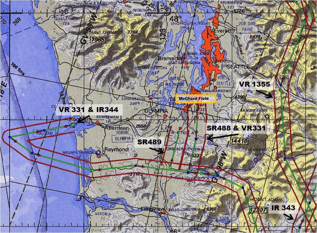
19 COMMONLY FLOWN MTRs NOT FOR 19
20 MILITARY TRAINING ROUTE TO-DO LIST 1. While flight planning, carefully check charts for the presence of MTRs and avoid them if possible. 2. Since only the route centerline of an MTR is depicted on sectional charts, military aircraft may be miles on either side of centerline within the route corridor. Be especially vigilant anywhere near a charted route centerline. 3. Contact the nearest Flight Service Station for planned military activity along a route. 4. Operate through an MTR above 1,500 feet AGL (verify its operating altitudes based on three or four digit identifier). 5. Cross an MTR at 90 degrees to minimize time spent within the route. 6. If you see a military aircraft, assume he does not see you. Take action to avoid coming within 500 feet of that aircraft. 20
21 COLLISION AVOIDANCE TIPS 1. Clear constantly for other aircraft, both visually and over the radio. 2. Know where high-density traffic areas are. 3. Obtain an IFR clearance or participate in radar flight following whenever possible and continue to practice see and avoid at all times. 4. Use landing lights at lower altitudes, especially when near airports. 5. Announce your intentions on UNICOM and use standard traffic pattern procedures at uncontrolled airfields 6. Always use your Mode C transponder. 7. Use the appropriate hemispherical altitudes and don t let your altitude wander. 8. Fly as high as possible. 9. Keep your windows and windscreen clean and clear. A bug on the windscreen can obstruct aircraft coming your way. 10. Properly manage tasks in the air. A cockpit gets very busy. Learn the proper methods to reduce workload demands and time crunches. 11. Don t get complacent during instruction! Instructors make mistakes too. Many mid-air collisions occur during periods of instruction or supervision. 12. When flying at night avoid white light in the cockpit. White light, even if used momentarily, disrupts your night vision. Use flashlights in the cockpit with red or green lenses. 13. Beware of wake turbulence. Especially watch out for heavy aircraft. 14. Understand the limitations of your eyes and use proper visual scanning techniques. If another aircraft appears to have no relative motion but is increasing in size, it is on a collision course with you. 15. Clear before and during all climbs, descents, and turns. 16. Above all, AVOID COMPLACENCY! There is no guarantee that everyone is flying by the rules or that everyone is where they are supposed to be, SEE AND BE SEEN! 21

22 IMPORTANT CONTACT INFORMATION 62 AW Wing Safety Office (253) AW Base Operations (253) Seattle, WA Flight Standards District Office (425) This brochure contains information regarding mid-air collision avoidance, wake turbulence, jet blast awareness, and the operations at JBLM - McChord Field. If you have questions concerning these topics please feel free to contact us anytime! 22
23 23
129 th RQW/SE P.O. Box 103, MS#1 Moffett Federal Airfield, CA
 MID-AIR COLLISION AVOIDANCE (MACA) HANDBOOK 129 th RQW/SE P.O. Box 103, MS#1 Moffett Federal Airfield, CA 94035-0103 129TH RESCUE WING MOFFETT FEDERAL AIRFIELD, CA 1 NOV 2013 TABLE OF CONTENTS FLYING SAFETY
MID-AIR COLLISION AVOIDANCE (MACA) April 2017
 April 2017") S 167th Airlift Wing Eastern WV Regional Airport Shepherd Field (KMRB) Martinsburg, WV MID-AIR COLLISION AVOIDANCE (MACA) April 2017 S 167th AW Flight Safety Office Phone: 304-616-5235 INTRODUCTION The
S 167th Airlift Wing Eastern WV Regional Airport Shepherd Field (KMRB) Martinsburg, WV MID-AIR COLLISION AVOIDANCE (MACA) April 2017 S 167th AW Flight Safety Office Phone: 304-616-5235 INTRODUCTION The
MID-AIR COLLISION AVOIDANCE (MACA)
") 167th Airlift Wing Eastern WV Regional Airport Shepherd Field (KMRB) Martinsburg, WV MID-AIR COLLISION AVOIDANCE (MACA) Always be vigilant of low-flying, fast-moving military aircraft in the red-shaded
167th Airlift Wing Eastern WV Regional Airport Shepherd Field (KMRB) Martinsburg, WV MID-AIR COLLISION AVOIDANCE (MACA) Always be vigilant of low-flying, fast-moving military aircraft in the red-shaded
ex) & Comple nce Avoidan 1 August 2010
 & Comple nce Avoidan 1 August 2010") 23 rd Wing, Detachment 1 MacDilll Air Force Base (Deployed Fighter Unit Comple ex) & Avon Park Air Force Range (Restricted Area R-2901) Mid-Air Collision Avoidan nce ( M.A.C. A.) 1 August 2010 Purpose
23 rd Wing, Detachment 1 MacDilll Air Force Base (Deployed Fighter Unit Comple ex) & Avon Park Air Force Range (Restricted Area R-2901) Mid-Air Collision Avoidan nce ( M.A.C. A.) 1 August 2010 Purpose
Pope Field, NC MID-AIR COLLISION AVOIDANCE
 Pope Field, NC MID-AIR COLLISION AVOIDANCE 2017 43 rd Air Mobility Operations Group Flight Safety, Pope Field, NC Tel: (910)394-8383/ 8389 Fax: (910)394-8098 E-mail:43AMOGW.SE1@US.AF.MIL The potential
DIRECCION DE PERSONAL AERONAUTICO DPTO. DE INSTRUCCION PREGUNTAS Y OPCIONES POR TEMA
 T E M : 0322 INSTRUTOR_DVNED_07_PROEDURES & IRPT OPS OD_PREG: P R E G U N T : RPT: 6436 n airport without a control tower lies within the controlled airspace of an airport with an operating tower. ccording
MID-AIR COLLISION AVOIDANCE (MACA)
") 437 th Airlift Wing Joint Base Charleston, SC MID-AIR COLLISION AVOIDANCE (MACA) November 2017 437 AW Flight Safety Office Joint Base Charleston, SC Tel: 843-963-5600 Fax: 843-963-4030 437aw.FlightSafety@us.af.mil
437 th Airlift Wing Joint Base Charleston, SC MID-AIR COLLISION AVOIDANCE (MACA) November 2017 437 AW Flight Safety Office Joint Base Charleston, SC Tel: 843-963-5600 Fax: 843-963-4030 437aw.FlightSafety@us.af.mil
AIRMAN S INFORMATION MANUAL. Enroute
 AIRMAN S INFORMATION MANUAL AIM 52 AIRPORT LIGHTING AND MARKING AIDS Airport Beacons Operation of the airport rotating beacon during the daytime indicates the weather in the Class D airspace is below basic
92d/141st AIR REFUELING WING SAFETY OFFICE FAIRCHILD AIR FORCE BASE WASHINGTON (509) /7026
 /7026") FREQUENCY REFERENCE GUIDE Fairchild AFB ATIS 257.625 UHF Ground 123.6 Tower 120.35 Spokane Approach 123.75 / 133.35 Spokane International (Geiger Field) ATIS 124.325 CLNC DEL 127.55 Ground 121.9 Tower
FREQUENCY REFERENCE GUIDE Fairchild AFB ATIS 257.625 UHF Ground 123.6 Tower 120.35 Spokane Approach 123.75 / 133.35 Spokane International (Geiger Field) ATIS 124.325 CLNC DEL 127.55 Ground 121.9 Tower
MID-AIR COLLISION AVOIDANCE
 MID-AIR COLLISION AVOIDANCE Information Current As of May 2018 Prepared in the interest of Aviation Safety by the 436 AW Flight Safety Office - Dover AFB, DE Phone: 302-677-2048 Fax: 302-677-2144 E-mail:
Section 3. Wake Turbulence
 1 of 12 7/31/2014 4:19 PM AIM 7/24/14 Section 3. Wake Turbulence 7-3-1. General a. Every aircraft generates a wake while in flight. Initially, when pilots encountered this wake in flight, the disturbance
APPENDIX F AIRSPACE INFORMATION
 APPENDIX F AIRSPACE INFORMATION Airspace Use DEFINITION OF AIRSPACE Airspace, or that space which lies above a nation and comes under its jurisdiction, is generally viewed as being unlimited. However,
CAUTION: WAKE TURBULENCE
 CAUTION: WAKE TURBULENCE This was the phrase issued while inbound to land at Boeing Field (BFI) while on a transition training flight. It was early August, late afternoon and the weather was clear, low
a. Aeronautical charts DID THIS IN LESSON 2
 AIRMAN CERTIFICATION STANDARDS: REMOTE PILOT SMALL: You will know and be able to explain in writing or oral form the below tasks regarding AIRPORT OPERATIONS Task References Objective Task B. Airport Operations
Fresno Area Mid-Air Collision Avoidance Program (MACA)
") Fresno Area Mid-Air Collision Avoidance Program (MACA) 144 th Fighter Wing California Air National Guard Fresno, CA 1 This pamphlet is courtesy of the 144 th Fighter Wing located at the California Air
Fresno Area Mid-Air Collision Avoidance Program (MACA) 144 th Fighter Wing California Air National Guard Fresno, CA 1 This pamphlet is courtesy of the 144 th Fighter Wing located at the California Air
Chapter The All-new, World-class Denver International Airport Identify Describe Know Describe Describe
 Chapter 10 The aerospace subject is very large and diverse. As seen in previous chapters, there are many subject areas. So far you have learned about history, weather, space and aerodynamics. Now you will
CHAPTER 6:VFR. Recite a prayer (15 seconds)
") CHAPTER 6:VFR Recite a prayer (15 seconds) ATM TOPIC 1. INTRODUCTION TO AIR TRAFFIC MANAGEMENT,TYPE OF CONTROL AREAS & FLIGHT PLAN 2. AERODROME CONTROL 3. AREA CONTROL 4. APPROACH CONTROL --------------------------------------mid-term
CHAPTER 6:VFR Recite a prayer (15 seconds) ATM TOPIC 1. INTRODUCTION TO AIR TRAFFIC MANAGEMENT,TYPE OF CONTROL AREAS & FLIGHT PLAN 2. AERODROME CONTROL 3. AREA CONTROL 4. APPROACH CONTROL --------------------------------------mid-term
Wake Turbulence All aircraft produce wake turbulence, which consists of wake vortices formed any time an airfoil is producing lift.
 Wake Turbulence Wake Turbulence All aircraft produce wake turbulence, which consists of wake vortices formed any time an airfoil is producing lift. 2 Wake Turbulence Occurrences Many pilots have received
Collision Avoidance UPL Safety Seminar 2012
 Collision Avoidance UPL Safety Seminar 2012 Contents Definition Causes of MAC See and avoid Methods to reduce the risk Technologies Definition MID AIR COLLISION A Mid-Air Collision (MAC) is an accident
USE OF RADAR IN THE APPROACH CONTROL SERVICE
 USE OF RADAR IN THE APPROACH CONTROL SERVICE 1. Introduction The indications presented on the ATS surveillance system named radar may be used to perform the aerodrome, approach and en-route control service:
Class B Airspace. Description
 Class B Airspace Ref. AIM 3-2-3 and FAR 91.131 Surrounds certain large airports Within each Class B airspace area, there are multiple segments with different ceiling/floor altitudes. Example: 70/30 = ceiling
WHITEMAN AFB, MO FIELD INFORMATION FIELD LIGHTING NAVIGATIONAL AIDS
 WHITEMAN AFB, MO FIELD INFORMATION FIELD ELEVATION 871 FT RUNWAY 01/19 LENGTH AND WIDTH 12,400 X 200 FIELD LIGHTING High Intensity Runway Lights Precision Approach Path Indicators Sequences Flashing Lights
II.B. Runway Incursion Avoidance
 References: AC 91-73 Objectives Key Elements Elements Schedule Equipment IP s Actions SP s Actions Completion Standards The student should develop knowledge of the elements related to proper incursion
60th Air Mobility Wing FAA Sacramento Flight Standards District Office
 MIDAIR COLLISION AVOIDANCE TRAVIS AFB CA March 2011 Contact Information 60th Air Mobility Wing Flight Safety Office (707) 424-1115 Fax (707) 424-1123 Airfield Management (707) 424-0028 Tower Chief (707)
PRE-SOLO WRITTEN EXAM. Student Name:
 PRE-SOLO WRITTEN EXAM Student Name: Date: Instructor Name: INTRODUCTION As specified in FAR 61.87, you must demonstrate satisfactory knowledge of appropriate portions of FAR Parts 61 and 91 to an authorized
Chapter 9 - Airspace: The Wild Blue, Green & Red Yonder
 I5 Class G Airspace 38. [I4/3/3] What minimum visibility and clearance from clouds are required for VFR operations in Class G airspace at 700 feet AGL or lower during daylight hours? A. mile visibility
THE VILLAGES AVIATION CLUB. SAFETY BRIEF November 2016
 THE VILLAGES AVIATION CLUB SAFETY BRIEF November 2016 Welcome Back Snowbirds When are you going home? If you see a man wearing a hat like this, go over and say Welcome Home. You ll make his day. Sure,
PLAN Anoka County - Blaine Airport
 Reliever Airports: NOISE ABATEMENT PLAN Anoka County - Blaine Airport INTRODUCTION The noise abatement plan for the Anoka County-Blaine Airport was prepared in recognition of the need to make the airport
Appendix K: MSP Class B Airspace
 Appendix K: MSP Class B Airspace K All of the open sky covering the United States, from less than an inch off the ground all the way to outer space, is part of America s airspace. This airspace resource
Gleim Private Pilot Syllabus Fifth Edition, 3rd Printing Updates March 2016
 Page of Gleim Private Pilot Syllabus Fifth Edition, rd Printing Updates March 0 NOTE: Text that should be deleted is displayed with a line through it. New text is shown with a blue background. If you see
EXAMPLE RADIO SCRIPTS. Fly Safe! Flight Following Wichita Approach, this is, checking in at,
 EXAMPLE RADIO SCRIPTS Wichita Approach Control offers flight following, wind & altimeter readings and practice approaches for VFR aircraft. The following scripts may prove helpful when requesting services.
LAPL(A)/PPL(A) question bank FCL.215, FCL.120 Rev OPERATIONAL PROCEDURES 070
/PPL(A) question bank FCL.215, FCL.120 Rev OPERATIONAL PROCEDURES 070") OPERATIONAL PROCEDURES 070 1 1 Which one of the following statements is false? An accident must be reported if, between the time that anyone boards an aircraft to go flying and until everyone has left
OPERATIONAL PROCEDURES 070 1 1 Which one of the following statements is false? An accident must be reported if, between the time that anyone boards an aircraft to go flying and until everyone has left
Pre-Solo and BFR Written
 Sky Sailing,Inc 31930 Highway 79 Warner Springs Ca 92086 e-mail soar@skysailing.com www.skysailing.com (760) 782-0404 Fax 782-9251 Safety Is No Accident Choose the most correct answer: Pre-Solo and BFR
Fresno Area Mid-Air Collision Avoidance Program (MACA) California Air National Guard 144 th Fighter Wing, Fresno, CA
 California Air National Guard 144 th Fighter Wing, Fresno, CA") Fresno Area Mid-Air Collision Avoidance Program (MACA) California Air National Guard 144 th Fighter Wing, Fresno, CA As of March 2013 Mid-Air Collision Avoidance This briefing contains material that can
Fresno Area Mid-Air Collision Avoidance Program (MACA) California Air National Guard 144 th Fighter Wing, Fresno, CA As of March 2013 Mid-Air Collision Avoidance This briefing contains material that can
Class Alpha. In addition, if you fly above FL240 your aircraft must have DME or a suitable RNAV system.
 Go For It Class Alpha Class A airspace is from 18,000 feet MSL to Flight Level 600 (60,000 feet pressure altitude). Its lateral extent includes the contiguous U.S. and Alaska, and extends 12 nm from the
1.1.3 Taxiways. Figure 1-15: Taxiway Data. DRAFT Inventory TYPICAL PAVEMENT CROSS-SECTION LIGHTING TYPE LENGTH (FEET) WIDTH (FEET) LIGHTING CONDITION
 WIDTH (FEET) LIGHTING CONDITION") 1.1.3 Taxiways EWN has an extensive network of taxiways and taxilanes connecting the terminal, air cargo, and general aviation areas with the runways as listed in Figure 1-15. A 50-foot wide parallel taxiway
1.1.3 Taxiways EWN has an extensive network of taxiways and taxilanes connecting the terminal, air cargo, and general aviation areas with the runways as listed in Figure 1-15. A 50-foot wide parallel taxiway
TRAVIS AIRSPACE. For more information visit the Travis AFB Midair Collision Avoidance (MACA) public website at:
 public website at:") MIDAIR COLLISION AVOIDANCE TRAVIS AFB CA January 2007 TRAVIS AIRSPACE The airspace serviced by Travis Approach Control is used by military aircraft operating in this area, along with IFR and numerous
MIDAIR COLLISION AVOIDANCE TRAVIS AFB CA January 2007 TRAVIS AIRSPACE The airspace serviced by Travis Approach Control is used by military aircraft operating in this area, along with IFR and numerous
GENERAL INFORMATION Aircraft #1 Aircraft #2
 GENERAL INFORMATION Identification number: 2007075 Classification: Serious incident Date and time 1 of the 2 August 2007, 10.12 hours occurrence: Location of occurrence: Maastricht control zone Aircraft
THE VILLAGES AVIATION CLUB. November 2014 SAFETY BRIEF
 THE VILLAGES AVIATION CLUB November 2014 SAFETY BRIEF IT WAS DARK, VERY DARK SO LETS GO FLYING SURE, YOU GET AN EXTRA HOURS SLEEP, BUT WHEN DO YOU GO FLYING? REVIEW OF NIGHT FLYING REGS AND TIPS Night
VFR PHRASEOLOGY. The word IMMEDIATELY should only be used when immediate action is required for safety reasons.
 VFR PHRASEOLOGY 1. Introduction 1.1. What is phraseology? The phraseology is the way to communicate between the pilot and air traffic controller. This way is stereotyped and you shall not invent new words.
According to FAA Advisory Circular 150/5060-5, Airport Capacity and Delay, the elements that affect airfield capacity include:
 4.1 INTRODUCTION The previous chapters have described the existing facilities and provided planning guidelines as well as a forecast of demand for aviation activity at North Perry Airport. The demand/capacity
PLEASE CALL LAKENHEATH APPROACH CONTROL ON / Within 20 Miles of the CMATZ
 1 MID AIR COLLISION AVOIDANCE Mid-air collision avoidance has increasingly become an important topic within both military and civilian aviation. The purpose of this pamphlet is to provide information about
MetroAir Virtual Airlines
 MetroAir Virtual Airlines NAVIGATION BASICS V 1.0 NOT FOR REAL WORLD AVIATION GETTING STARTED 2 P a g e Having a good understanding of navigation is critical when you fly online the VATSIM network. ATC
FLASHCARDS AIRSPACE. Courtesy of the Air Safety Institute, a Division of the AOPA Foundation, and made possible by AOPA Holdings Company.
 AIRSPACE FLASHCARDS Courtesy of the Air Safety Institute, a Division of the AOPA Foundation, and made possible by AOPA Holdings Company. The Air Safety Institute is dedicated to making flying easier and
DO NOT BEGIN THIS WORK UNTIL YOU HAVE COMPLETED ALL REQUIRED ASSIGNED READING AND EXERCISES.
 DO NOT BEGIN THIS WORK UNTIL YOU HAVE COMPLETED ALL REQUIRED ASSIGNED READING AND EXERCISES. Gardner Textbook Review Questions to prepare for Class #12 Answer these on notebook paper (or a text file) then
NAVIGATION: CHARTS, PUBLICATIONS, FLIGHT COMPUTERS (chapters 7 & 8)
") NAVIGATION: CHARTS, PUBLICATIONS, FLIGHT COMPUTERS (chapters 7 & 8) LONGITUDE AND LATITUDE 1. The location of an airport can be determined by the intersection of lines of latitude and longitude. a. Lines
NAVIGATION: CHARTS, PUBLICATIONS, FLIGHT COMPUTERS (chapters 7 & 8) LONGITUDE AND LATITUDE 1. The location of an airport can be determined by the intersection of lines of latitude and longitude. a. Lines
Source: Chippewa Valley Regional Airport ASOS, Period of Record
 Chapter 1 Inventory Runway wind coverage is the percentage of time a runway can be used without exceeding allowable crosswind velocities. Allowable crosswind velocities vary depending on aircraft size
CATCODE ] CATCODE
![CATCODE ] CATCODE](/thumbs/82/85644630.jpg "CATCODE ] CATCODE") Runways. FAC: 1111 CATCODE: 111111 OPR: AFCEC/COS OCR: AF/A3O-A 1.1. Description. The runway is the paved surface provided for normal aircraft landings and take offs. Runways are classified as either Class
Runways. FAC: 1111 CATCODE: 111111 OPR: AFCEC/COS OCR: AF/A3O-A 1.1. Description. The runway is the paved surface provided for normal aircraft landings and take offs. Runways are classified as either Class
IFR SEPARATION USING RADAR
 IFR SEPARATION USING RADAR 1. Introduction When flying IFR inside controlled airspace, air traffic controllers either providing a service to an aircraft under their control or to another controller s traffic,
A Hong Kong-based Virtual Airline. Hong Kong VFR Guide. VOHK Training Team. Version 1.2
 A Hong Kong-based Virtual Airline Hong Kong VFR Guide VOHK Training Team Version 1.2 Flight Simulation Use Only 5 March 2017 1 Introduction This Guide provides necessary information and guidelines for
Operating Safely. A Fundamental Guide to FAA RADAR Operations. Federal Aviation Administration Near Airports
 Operating Safely Near Airports A Fundamental Guide to FAA RADAR Operations Presented to: Pacific Air Soaring Counsel - PASCO By: Donald A. Brooks, Air Traffic Manager Reno TRACON/Tower November 4 th, 2006
Chapter 6. Nonradar. Section 1. General DISTANCE
 12/10/15 JO 7110.65W Chapter 6. Nonradar Section 1. General 6 1 1. DISTANCE Use mileage based (DME and/or ATD) procedures and minima only when direct pilot/controller communications are maintained. FIG
Safety Syllabus. VFR into IMC
 VFR into IMC A syllabus designed to help protect pilots against GA's most fatal type of weather-related accident: VFR into IMC. Recommended for use by flight instructors and schools. 2017 421 Aviation
Mid-Air Collision Avoidance
 4th Fighter Wing Seymour Johnson AFB, NC Mid-Air Collision Avoidance Published By 4th Fighter Wing Flight Safety Seymour Johnson AFB, NC (919) 722-4227 www.seeandavoid.org Airfield Identifier: GSB If you
Commercial Pilot Practical Test Briefing
 Commercial Pilot Practical Test Briefing 1. What certificates and documents must you have on board the aircraft prior to flight? 2. Locate the following inspections, as appropriate, in the airframe and
142 ND Fighter Wing Midair Collision Avoidance Program
 142 ND Fighter Wing Midair Collision Avoidance Program OBJECTIVES Mid Air Collision realities 142Fighter Wing - 123 rd Fighter Squadron Mission F15 Local Operations Transient Aircraft Operations Night
Stanfield VOR Procedures
 Stanfield VOR This PowerPoint is not intended as a directive. It is intended to serve as a tool to communicate the training community s best practices. Any questions or concerns to these procedures are
Pre-Solo Written Exam
 Pre-Solo Written Exam Introduction 14 CFR Part 61.87(b) requires student pilots to demonstrate aeronautical knowledge by completing a knowledge test prior to soloing an aircraft. The test must address
Intro to Small Unmanned Aircraft Systems & Recreational Drones
 Intro to Small Unmanned Aircraft Systems & Recreational Drones Controlled Airspace Controlled Airspace has defined dimensions within which Air Traffic Control (ATC) services are provided. The level of
2. CANCELLATION. AC 90-23F, Aircraft Wake Turbulence, dated February 20, 2002, is canceled.
 U.S. Department of Transportation Federal Aviation Administration Advisory Circular Subject: Aircraft Wake Turbulence Date: 2/10/14 Initiated by: AFS-400 AC No: 90-23G Change: 1. PURPOSE. This advisory
JACK EDWARDS NATIONAL AIRPORT (JKA) GULF SHORES, AL
 GULF SHORES, AL") OCTOBER 26-27, 2018 JACK EDWARDS NATIONAL AIRPORT (JKA) GULF SHORES, AL SPECIAL FLIGHT PROCEDURES EFFECTIVE: Thursday Oct 25, 2018 12:00 NOON CDT until 6:00 PM CDT Friday Oct 26, 2018 7:00 AM CDT until
OCTOBER 26-27, 2018 JACK EDWARDS NATIONAL AIRPORT (JKA) GULF SHORES, AL SPECIAL FLIGHT PROCEDURES EFFECTIVE: Thursday Oct 25, 2018 12:00 NOON CDT until 6:00 PM CDT Friday Oct 26, 2018 7:00 AM CDT until
STUDENT PILOT PRE-CROSS-COUNTRY WRITTEN EXAM
 DO NOT WRITE ON THIS TEST FEB 2013 STUDENT PILOT PRE-CROSS-COUNTRY WRITTEN EXAM This test is required prior to solo cross-country per AFMAN This test is not required if the student has passed the FAA Knowledge
Gleim Instrument Pilot FAA Knowledge Test Prep 2018 Edition, 1st Printing Updates April 2018
 Page 1 of 8 Gleim Instrument Pilot FAA Knowledge Test Prep 2018 Edition, 1st Printing Updates April 2018 NOTE: Text that should be deleted is displayed with a line through it. New text is shown with a
Reliever Airports: NOISE ABATEMENT PLAN Flying Cloud Airport (FCM)
") Reliever Airports: NOISE ABATEMENT PLAN Flying Cloud Airport (FCM) INTRODUCTION The Noise Abatement Plan (FCM Plan) for the Flying Cloud Airport has been prepared in recognition of the need to make the
Reliever Airports: NOISE ABATEMENT PLAN Flying Cloud Airport (FCM) INTRODUCTION The Noise Abatement Plan (FCM Plan) for the Flying Cloud Airport has been prepared in recognition of the need to make the
VFR into IMC. Safety Syllabus
 A DIVISION OF THE AOPA FOUNDATION Safety Syllabus VFR into IMC A syllabus designed to help protect pilots against GA's most fatal type of weather-related accident: VFR into IMC. Recommended for use by
PRESOLO WRITTEN EXAM
 PRESOLO WRITTEN EXAM Date of Exam STUDENT INFORMATION Student Name Student Pilot Certificate Number FLIGHT INSTRUCTOR INFORMATION Instructor Instructor Certificate Number 1 INTRODUCTION Student Actions:
CE 563 Airport Design
 CE 563 Airport Design Prevent aircraft collisions Prevent aircraft collisions with obstructions Expedite and maintain an orderly flow of air traffic Air traffic control system command center Herndon, VA
PASCO (Pacific Soaring Council) ADVISORY TO GLIDER PILOTS
 ADVISORY TO GLIDER PILOTS") PASCO (Pacific Soaring Council) ADVISORY TO GLIDER PILOTS RECOMMENDED COMMUNICATIONS PROCEDURES FOR FLYING GLIDERS IN THE VICINITY OF RENO, NV The airspace around Reno has the highest number of glider-commercial
PASCO (Pacific Soaring Council) ADVISORY TO GLIDER PILOTS RECOMMENDED COMMUNICATIONS PROCEDURES FOR FLYING GLIDERS IN THE VICINITY OF RENO, NV The airspace around Reno has the highest number of glider-commercial
A PILOT S GUIDE To understanding ATC operations at Lancaster Airport
 A PILOT S GUIDE To understanding ATC operations at Lancaster Airport - 1 - Welcome to the Lancaster Airport (This material shall be used for informational purposes only) The Air Traffic Controllers at
SAFETY PROCEDURES AND PRACTICES
 SAFETY PROCEDURES AND PRACTICES Pro Flight Air, Inc. Springfield/Branson Regional Airport 2755 N. General Aviation Ave. Springfield, MO 65803 SAFETY PROCEDURES AND PRACTICES Career Pilot School, LLC 104
IFR SEPARATION WITHOUT RADAR
 1. Introduction IFR SEPARATION WITHOUT RADAR When flying IFR inside controlled airspace, air traffic controllers either providing a service to an aircraft under their control or to another controller s
RADIO COMMUNICATIONS AND ATC LIGHT SIGNALS
 RADIO COMMUICATIOS AD ATC LIGHT SIGALS VI - A ITRODUCTIO RADIO LICESE RADIO EQUIPMET PHRASEOLOGY LOST COMMUICATIO Receiver Transmitter Both Departure - Operating in and out of a controlled airport, as
VANCE AIR FORCE BASE MIDAIR COLLISION AVOIDANCE (MACA) LET S NOT MEET BY ACCIDENT!
 LET S NOT MEET BY ACCIDENT!") VANCE AIR FORCE BASE MIDAIR COLLISION AVOIDANCE (MACA) LET S NOT MEET BY ACCIDENT! Fel!ow Aviators, Midair collisions are an area of vital concern to everyone who flies an airplane. Historically, the number
VANCE AIR FORCE BASE MIDAIR COLLISION AVOIDANCE (MACA) LET S NOT MEET BY ACCIDENT! Fel!ow Aviators, Midair collisions are an area of vital concern to everyone who flies an airplane. Historically, the number
CHAPTER 5 SEPARATION METHODS AND MINIMA
 CHAPTER 5 SEPARATION METHODS AND MINIMA 5.1 Provision for the separation of controlled traffic 5.1.1 Vertical or horizontal separation shall be provided: a) between IFR flights in Class D and E airspaces
Point A to Point B Arrival By Jim Sweeney
 Point A to Point B Arrival By Jim Sweeney The first two installments of From Point A to Point B were published in the October and January issues of UltraFlight Magazine. They covered the Preparation/Departure
Contents. Subpart A General 91.1 Purpose... 7
 Contents Rule objective... 3 Extent of consultation... 3 Summary of comments... 4 Examination of comments... 6 Insertion of Amendments... 6 Effective date of rule... 6 Availability of rules... 6 Part 91
COMPANY POLICY Flight Safety & Operating Regulations
 1. FLIGHT PREPARATION a) Weather Briefing i) all pilots shall conduct a weather briefing before each flight to ensure they are aware of the current and forecast weather affecting the training area or route
FAA FORM UAS COA Attachment FAA
 Page 1 of 6 DEPARTMENT OF TRANSPORTATION FEDERAL AVIATION ADMINISTRATION CERTIFICATE OF WAIVER OR AUTHORIZATION ISSUED TO Xcam Aerials, Inc. 10197 SE 144th Place Summerfield, FL 34491 This certificate
Amendment of Restricted Areas R-2907A and R-2907B, Lake George, FL; and R-2910, Pinecastle, FL
 This document is scheduled to be published in the Federal Register on 07/03/2013 and available online at http://federalregister.gov/a/2013-16054, and on FDsys.gov 4910-13 DEPARTMENT OF TRANSPORTATION Federal
SANTA FE MUNICIPAL AIRPORT (SAF) SANTA FE, NM
 SANTA FE, NM") SEPTEMBER 13-15, 2018 SANTA FE MUNICIPAL AIRPORT (SAF) SANTA FE, NM SPECIAL FLIGHT PROCEDURES EFFECTIVE: Thursday Sept 13, 2018 12:00 NOON MDT until 7:00 PM MDT Friday Sept 14, 2018 7:00 AM MDT until 7:00
SEPTEMBER 13-15, 2018 SANTA FE MUNICIPAL AIRPORT (SAF) SANTA FE, NM SPECIAL FLIGHT PROCEDURES EFFECTIVE: Thursday Sept 13, 2018 12:00 NOON MDT until 7:00 PM MDT Friday Sept 14, 2018 7:00 AM MDT until 7:00
Number April 2016
 Luxembourg Air Safety Bulletin Number 16-001 - April 2016 This Air Safety Bulletin examines a number of hazards related to flying in and out, and in the vicinity of, Luxembourg Airport. As the Direction
National Transportation Safety Board Washington, D.C
 E PLURIBUS UNUM NATIONAL TRA SAFE T Y N S PORTATION B OAR D National Transportation Safety Board Washington, D.C. 20594 Safety Recommendation Date: June 25, 2004 In reply refer to: A-04-48 through -50
40 BEALEAFBI OCTOBER Chapter 8 RQ-4 OPERATIONS
 40 BEALEAFBI11-250 1 OCTOBER 2012 Chapter 8 RQ-4 OPERATIONS 8.1. CERTIFICATE OF AUTHORIZATION. Pilots will comply with each COA and LOA in effect between Beale and other Air Traffic Control (ATC) facilities.
Glossary. Part I Acronyms/Data Terminology. AIFSS -- Automated International Flight Service Station.
 Glossary Part I Acronyms/Data Terminology AC -- Air Carrier. AFSS -- Automated Flight Service Station. AIFSS -- Automated International Flight Service Station. ARTCC -- Air Route Traffic Control Center.
AVIATION OCCURRENCE REPORT A98W0216 LOSS OF SEPARATION
 AVIATION OCCURRENCE REPORT A98W0216 LOSS OF SEPARATION BETWEEN AIR CANADA BOEING 747-238 C-GAGC AND AIR CANADA BOEING 747-400 C-GAGM 55 NORTH LATITUDE AND 10 WEST LONGITUDE 27 SEPTEMBER 1998 The Transportation
APPENDIX D MSP Airfield Simulation Analysis
 APPENDIX D MSP Airfield Simulation Analysis This page is left intentionally blank. MSP Airfield Simulation Analysis Technical Report Prepared by: HNTB November 2011 2020 Improvements Environmental Assessment/
Appendix B Ultimate Airport Capacity and Delay Simulation Modeling Analysis
 Appendix B ULTIMATE AIRPORT CAPACITY & DELAY SIMULATION MODELING ANALYSIS B TABLE OF CONTENTS EXHIBITS TABLES B.1 Introduction... 1 B.2 Simulation Modeling Assumption and Methodology... 4 B.2.1 Runway
AIRPORTS There are two types of airport environments: controlled and uncontrolled. A controlled airport has an operating control tower, staffed by
 AIRPORTS There are two types of airport environments: controlled and uncontrolled. A controlled airport has an operating control tower, staffed by either Federal or privately-contracted air traffic controllers.
THE TOWER CONTROL POSITION (TWR)
") 1. Introduction THE TOWER CONTROL POSITION (TWR) The Aerodrome Local Control, or Tower (called TWR) controller has the responsibility of ensuring Air Traffic Control (ATC) Services within a restricted
1. Introduction THE TOWER CONTROL POSITION (TWR) The Aerodrome Local Control, or Tower (called TWR) controller has the responsibility of ensuring Air Traffic Control (ATC) Services within a restricted
Section 5. Radar Separation
 7/24/14 JO 7110.65V CHG 1 4/3/14 JO 7110.65V Section 5. 5 5 1. APPLICATION a. Radar separation must be applied to all RNAV aircraft operating at and below FL450 on Q routes or random RNAV routes, excluding
SOPs for Cedar Valley Airport UT10
 SOPs for Cedar Valley Airport UT10 Cedar Valley Airport is a privately owned airport located approximately 10 miles west of Lehi, Ut and 5 miles northeast of Cedar Fort, UT. The airport location is N40.3572
Private Pilot Flight Training
 Student: Date Completed: Private Pilot Flight Training TAXIING Objective: To develop the student's planning and technique in taxi operations. Elements: 1. Proper brake check and correct use of brakes.
Aerial Photography and Flight Planning
 Aerial Photography and Flight Planning What is VFR? Flight is to take place using visual references Must avoid clouds Normally have a distinguishable horizon Should have sight of the ground below, or in
Transcript. Practice Approaches. Featuring: John Krug
 Practice Approaches Featuring: John Krug Copyright PilotWorkshops.com, LLC. This material is available to members of the PilotWorkshops.com web site, which is the only place it can be legally obtained.
EFFECTIVE NOTAM KOUN SPECIAL FLIGHT PROCEDURES 09/08 NORMAN, OK
 KOUN WESTHEIMER AIRPORT NORMAN, OK 17 09/08 09/09 NOTAM SPECIAL FLIGHT PROCEDURES EFFECTIVE 12:00 Noon CDT until 7:30 PM CDT Thursday, September 7, 2017 7:00 AM CDT until 7:30 PM CDT Friday, September
HVA Pilot Information Guide Page 1
 PILOT INFORMATION GUIDE Revised: 21 November 2016 HVA Pilot Information Guide Page 1 Table of Contents Table of Contents... 2 Introduction... 3 Hidden Valley Airpark Procedures... 4 Airfield Description...
CASCADE OPERATIONAL FOCUS GROUP (OFG)
") CASCADE OPERATIONAL FOCUS GROUP (OFG) Use of ADS-B for Enhanced Traffic Situational Awareness by Flight Crew During Flight Operations Airborne Surveillance (ATSA-AIRB) 1. INTRODUCTION TO ATSA-AIRB In today
CASCADE OPERATIONAL FOCUS GROUP (OFG) Use of ADS-B for Enhanced Traffic Situational Awareness by Flight Crew During Flight Operations Airborne Surveillance (ATSA-AIRB) 1. INTRODUCTION TO ATSA-AIRB In today
Innovations in Aviation Flow Management REDUCING CONGESTION AND INCREASING CAPACITY
 Innovations in Aviation Flow Management REDUCING CONGESTION AND INCREASING CAPACITY Introduction With passenger volumes rising steadily, the global aviation system is facing a challenge: How to accommodate
 IFR 91.157 Must be instrument rated to fly special VFR at Night (civil twilight to civil twilight, sun 6 degrees below horizon) 91.159 Unless in a holding pattern of 2 minutes or less, VFR cruising altitude
Gleim Instrument Pilot FAA Knowledge Test 2015 Edition, 1st Printing Updates April 2015
 Page 1 of 5 Gleim Instrument Pilot FAA Knowledge Test 2015 Edition, 1st Printing Updates April 2015 NOTE: Text that should be deleted is displayed with a line through it. New text is shown with a blue