A Wild Place on the Frontier
|
|
|
- Alfred Hensley
- 5 years ago
- Views:
Transcription

1 National Park Service U.S. Department of the Interior Chiricahua National Monument A Wild Place on the Frontier Wilderness Building Blocks for Chiricahua National Monument
2 ON THE COVER The Balanced Rock Formation on Heart of Rock Trail Chiricahua National Monument Photograph by: NPS Staff
3 A Wild Place on the Frontier Wilderness Building Blocks for Chiricahua National Monument Chiricahua National Monument National Park Service East Rhyolite Creek Road Willcox, AZ Prepared by: Jesse Engebretson Interagency Wilderness Fellow Program National Park Service November 2012 i
4 Executive Summary This report consists of building blocks which provide a foundation for effectively integrating wilderness character into the management of Chiricahua National Monument s wilderness. This report s intention is to highlight the salient and unique components of the wilderness, determine each component s current condition, develop a shared understanding of their value and context and provide suggestions for improvement. Additionally, this report utilizes language relevant to wilderness character the consistent use of this language among monument staff and with the public provides a basis for mutual understanding of the complexities in the Wilderness Act and of wilderness stewardship in general. This is a document that is divided into chapters that collectively addresses the unique character of Chiricahua National Monument s wilderness. Chapter One provides an overview of wilderness character and describes its importance to monument managers. This chapter is based on content from Keeping it wild: An interagency strategy to monitor trends in wilderness character across the National Wilderness Preservation System (Landres et al., 2008). Chapter Two is a qualitative description of what is unique about the monument s wilderness, the challenges managers face in managing a wild space and how it fits into the larger story of the uniquely American wilderness project. Content from this chapter was derived from informal interviews with monument staff, coding and analysis of the wilderness character narrative meetings and an overview of historical and planning documents. Chapters Three through Seven outline measurements developed which capture the unique nature of the Chiricahua National Monument Wilderness and are indicative of the five qualities of wilderness character outlined in Keeping it Wild. Data compiled in 2017 will be compared with baseline data collected in 2012 to determine the state of wilderness character at that time. This process is to be repeated every five years in order to track changes in wilderness character and to better understand the practical implications of monument operations on the overall quality of the wilderness. The last chapter describes ways to integrate wilderness character into management and operations. It suggests simple steps, some unique to Chiricahua, that monument management can follow to better integrate wilderness character into decision making, public scoping and the overall management of Chiricahua s unique wilderness. ii
5 iii
6 Table of Contents Page Figures... v Tables... vi Appendices... viii List of Acronyms Used... ix Chapter One: Introduction to Wilderness Character...1 Chapter Two: Wilderness Character Narrative...5 Chapter Three: Natural Quality Measures Chapter Four: Untrammeled Quality Measures Chapter Five: Undeveloped Quality Measures Chapter Six: Opportunities for Solitude or Primitive and Unconfined Recreation Quality Measures Chapter Seven: Other Features Quality Measures Chapter Eight: Wilderness Stewardship Issues and Opportunities at Chiricahua National Monument.. 58 References Appendices iv
7 Figures Figure 1. Conceptual model of wilderness character monitoring Figure 2. Map of Sky Island region... 9 Figure 3. Map of development within 30km of the Chiricahua National Monument Wilderness Page v
8 Tables Table 1. Status of species of interest Table 2. Index of statuses of species of interest Table 3. Air quality data Table 4. Water quality data Table 5. Inherent weights for the fire return interval Table 6. Total development index value Table 7. Temporal value of trammeling Table 8. Level of biophysical manipulations Table 9. Values attributed to actions against wildlife Table 10. Temporal value of research installation Table 11. Level of impact on wilderness Table 12. Index values of research installations that intentionally maniulate the biophysical environment Table 13. Index value of NPS infrastructure Table 14. Inherent weights of different types of motor vehicles, motorized equipment and mechanical transport used in wilderness Table 15. Inherent weights for the actual uses of motor vehicles, motorized equipment and mechanical transport used in wilderness Table 16. Calculation of the use level value for emergency uses of motor vehicles, motorized equipment and mechanical transport Table 17. Calculation of the use level value for non-emergency uses of motor vehicles, motorized equipment and mechanical transport Table 18. Extent of unauthorized uses Table 19. Total score for all unauthorized uses Page vi
9 Table 20. Inherent weighting of activities, strategies, or built infrastructure related to border issues Table 21. Weighting of degrees of pervasiveness Table 22. Total index value of law enforcement activities related to border issues Table 23. Index value of facilities that decrease self-reliant recreation Table 24. Quality of cell phone reception Table 25. Management restrictions on visitor behavior Table 26. Conditional index value of CCC structures Table 27. Conditional index value of archeological sites Page vii
10 Appendices Page Appendix A. Natural Quality Data Table Appendix B. Untrammeled Quality Data Table Appendix C. Undeveloped Quality Data Table Appendix D. Solitude or Unconfined Type of Recreation Quality Table Appendix E. Other Features Quality Table viii
11 List of Acronyms Used ASMIS BORSTAR CCC CFS CHIR DHS EC GIS GMP GPRA IDA LCS NPS NWPS RPRS UDA USFS SEAZ SODN TDS Archeological Sites Management Information System Border Patrol Search, Trauma, and Rescue Civilian Conservation Corps Cubic feet per second Chiricahua National Monument Department of Homeland Security Electrical conductivity Geographic Information System General Management Plan Government Performance and Results Act International Dark-Sky Association List of Classified Structures National Park Service National Wilderness Preservation System Research Permit and Reporting System Undocumented alien United States Forest Service Southeast Arizona Group Sonoran Desert Network Total dissolved solids ix
12 Chapter One Introduction to Wilderness Character In 1964, the Wilderness Act was signed into law by President Lyndon B. Johnson. This created a formal mechanism for designating wilderness and mandated the protection of wilderness character. Despite this mandate, the four wilderness management agencies have lacked a consistent definition of wilderness character and the tools to evaluate how it is changing over time. A monitoring framework was utilized in this report to determine indicative measures to track trends in wilderness character over time. This framework is outlined in Keeping it Wild: An Interagency Strategy to Monitor Trends in Wilderness Character Across the National Wilderness Preservation System (2008). It provides a nationally consistent approach to describing and assessing trends in wilderness character across the full extent of the National Wilderness Preservation System (NWPS). What is Wilderness Character? The 1964 Wilderness Act does not define wilderness character and the congressional committees that debated the Wilderness Act did not discuss its meaning (Scott, 2002). The United States Forest Service s (USFS) national framework for monitoring wilderness character (Landres et al., 2005) identified three mutually reinforcing societal ideals integral to the historical purpose of wilderness and to understanding wilderness character: Natural environments relatively free from modern human manipulation and impacts; Personal experiences in natural environments that are relatively free from the encumbrances and signs of modern society; and Symbolic meanings of humility, restraint, and interdependence in how individuals and society view their relationship to nature. Wilderness character may be described as the combination of biophysical, experiential, and symbolic ideals that distinguish wilderness from other lands. These ideals combine to form a complex and subtle set of relationships among the land, its management, its users, and the meanings people associate with wilderness. In total, these relationships and meanings are described as wilderness character. Howard Zahniser, the primary author of the Wilderness Act, wrote that to know the wilderness is to know a profound humility, to recognize one s littleness, to sense dependence and interdependence, indebtedness, and responsibility (1956). This and other writings of Zahniser strongly reinforce the idea that, fundamentally, wilderness character is the capacity of an area to elicit humility, awaken a sense of relationship and 1
13 interconnectedness with the community of life, and evoke a feeling of restraint and obligation toward nature. Five Qualities of Wilderness Character Congressional intent for the meaning of wilderness character is expressed in the Definition of Wilderness, Section 2(c) of the 1964 Wilderness Act (McCloskey, 1999; Rohlf and Honnold 1988; Scott 2002). The USFS national framework (Landres et al., 2005) applied this congressional intention to identify four tangible qualities of wilderness that make the idealized description of wilderness character relevant and practical to wilderness stewardship: Natural The Wilderness Act states that wilderness is protected and managed so as to preserve its natural conditions. In other words, wilderness ecological systems are substantially free from the effects of modern civilization. This quality is degraded by intended or unintended effects of the actions of modern people on the ecological systems inside the wilderness. Untrammeled The Wilderness Act states that wilderness is an area where the earth and its community of life are untrammeled by man, and generally appears to have been affected primarily by the forces of nature. In short, wilderness is essentially unhindered and free from modern human control or manipulation. This quality is degraded by modern human activities or actions that control or manipulate the components or processes of ecological systems inside the wilderness. Undeveloped The Wilderness Act states that wilderness is an area of undeveloped federal land retaining its primeval character and influence, without permanent improvements or human habitation, where man himself is a visitor who does not remain and with the imprint of man s work substantially unnoticeable. This quality is degraded by the presence of structures, installations, habitations, and by the use of motor vehicles, motorized equipment, or mechanical transport that increases people s ability to occupy or modify the environment. Solitude or a primitive and unconfined type of recreation The Wilderness Act states that wilderness has outstanding opportunities for solitude or a primitive and unconfined type of recreation. This quality is about the opportunity for people to experience wilderness; it is not directly about visitor experiences per se. This quality is degraded by settings that reduce these opportunities, such as visitor encounters, signs of modern civilization, recreation facilities, and management restrictions on visitor behavior. 2
 has defined a fifth quality, Other Features, based on the last clause of Section 2(c) of the Wilderness Act which states that a wilderness may also contain ecological,")
14 Other features In many cases, a park may find that the above four qualities do not fully express the values and features found in its wilderness areas. The National Park Service (NPS) has defined a fifth quality, Other Features, based on the last clause of Section 2(c) of the Wilderness Act which states that a wilderness may also contain ecological, geological, or other features of scientific, educational, scenic, or historical value. This fifth quality may be used by a park to capture elements that are not included in the other four qualities. Unlike the preceding four qualities that apply throughout every wilderness, this fifth quality is unique to an individual wilderness based on the features that are inside that wilderness. These features typically occur only in specific locations within a wilderness and include cultural resources, paleontological localities, or any feature generally not under the other four qualities that have scientific, educational, scenic, or historical value. This quality is preserved or improved by the preservation or restoration of such features, even when such management actions degrade other qualities of wilderness character. Loss or impacts to such features degrade this quality of wilderness character. These five qualities together comprise an approximation of wilderness character for wilderness planning, stewardship, and monitoring. For the purpose of this interagency monitoring strategy, all five qualities are equally important and none is held in higher or lower regard than the others. Wilderness Character Monitoring Wilderness character monitoring protocols are outlined in Keeping it Wild. Figure 1 illustrates this hierarchical monitoring protocol by representing the tangible aspects of wilderness character to specific indicators and measures. Wilderness Character and Section 2(c) Definition of Wilderness are taken directly from the 1964 Wilderness Act. Qualities of Wilderness, Monitoring Questions for each Quality, Indicators for each Monitoring Question, and Measures for each Indicator were developed for the monitoring protocol outlined in Keeping it Wild. The Section 2(c) Definition of Wilderness was used to identify specific qualities of wilderness that are related to the concept of wilderness character. Each of these qualities of wilderness is then sequentially divided into a set of monitoring questions, indicators, and measures. Monitoring questions set specific monitoring goals, indicators are the types of information used to answer each monitoring question, and measures are the numeric values that are measured or derived to quantify change over time in the Figure 1 Conceptual model of wilderness character monitoring (Landres et al., 2008) 3
15 indicator. In Figure 1, the downward-pointing arrowheads show that the concept of wilderness character drives the selection of all the subsequent elements and ultimately the data that are collected. The upward-pointing arrowheads show how data collected on the measures are used to evaluate successively higher elements in the model. As park staff knows, monitoring strategies often become obsolete over time. Wilderness character monitoring is an evolving framework that can shift in relation to advances in knowledge or technology in collecting data over time. Given this, there may be measures in this document that may seem less indicative of their respective qualities in the future. Because of this, measures can be altered or eliminated from the monitoring strategy if they are less informative in the coming years. Why is this important to managers? Wilderness character can also be preserved or degraded by the operations of park managers. For example, the choices to not use a chainsaw for trail maintenance, erect new fencing, or suppress a naturally ignited fire may preserve certain qualities of wilderness character. In contrast, other management actions, such as limiting travel to trails or authorizing administrative use of motorized equipment and mechanical transportation, may diminish certain qualities of wilderness character. The challenge of wilderness stewardship, however, is that decisions and actions taken to protect one aspect of wilderness character may diminish another aspect. For example, the use of herbicides to control the infestation of an invasive species benefits the natural ecosystem but also manipulates the biophysical environment. Given this, the accumulated result of seemingly small decisions and actions may cause a significant improvement or degradation of wilderness character over time. Because of this complexity, preserving wilderness character requires that managers approach wilderness stewardship with humility, respect, and restraint. Additionally, this report provides the use of language relevant to wilderness, such as the names and descriptions of the five qualities of wilderness character. The consistent use of this language among park staff and with the public provides a basis for mutual understanding about the complexities in the Wilderness Act and of wilderness stewardship in general. Lastly, in order to effectively manage wilderness, managers must understand its current state and future trends. Understanding the implications of park operations on the five qualities of wilderness character is integral to preserving Chiricahua s unique wilderness resource. 4
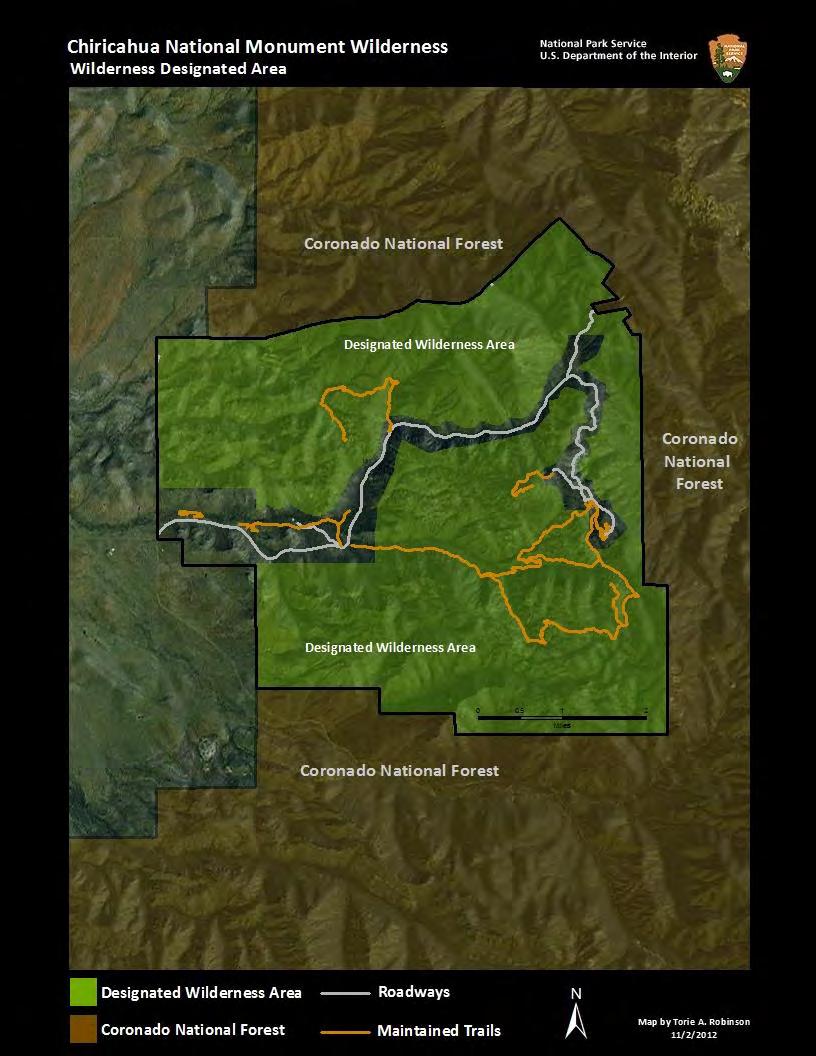
16 Chapter Two Wilderness Character Narrative The Chiricahua National Monument Wilderness is a unique and special place. This chapter is a qualitative description to communicate the often dialectical relationship between wilderness values and the reality of wilderness management at Chiricahua. Background of Chiricahua National Monument Wilderness Chiricahua National Monument is in southeast Arizona and contains 11,985 acres, of which 10,290 acres are designated as wilderness. Established by presidential proclamation in 1924, the monument was originally created to preserve natural rock formations unique to the Chiricahua Mountains, known as the Pinnacles in perpetuity. These volcanically formed rhyolite columns, in addition to the cultural history and ecological context of the region, are indicative of Chiricahua s unique character. In 1976, Congress designated a large portion of the monument as part of the National Wilderness Preservation System (NWPS). With an addition in 1984, a total of 10,290 acres is now designated as wilderness. A narrow paved corridor that includes the Bonita Canyon Road, Massai Point, Echo Canyon, and Sugarloaf parking lots, developed areas (visitor center, employee housing, maintenance yard, and campground) and Faraway Ranch are not part of the wilderness designated area. The monument is located approximately 40 kilometers southeast of Willcox, AZ, which has a population of approximately 3,800 people. Its wilderness designated area is surrounded on three sides by USFS land and on one side by private land. Approximately 14.5 miles of wilderness boundary is currently fenced to prevent illegal cattle grazing incursions. Coronado National Forest, which comprises most of the Chiricahua Mountains, contains a designated wilderness area approximately six miles south of the monument. Bonita Canyon Road, which was built by the Civilian Conservation Corps (CCC) in the 1930s, has a significant impact on the monument s wilderness. Nearly all of the monument s development and most of its visitor activity occurs along this road. Trailheads leading into the wilderness also start along this stretch of road or at the parking lots in the monument. Other than short administrative roads and a dirt road leading to the King of Lead mine, there are no other roads in the monument. 5

17 The Chiricahua Mountains is an inactive volcanic range twenty miles wide and forty miles long. It forms part of the Mexican Highland section of the Basin and Range Biogeographical Province and rises up dramatically from the valley floor to over nine thousand feet, cresting in a series of uneven, craggy peaks, due to its violent volcanic history. Tucked deep into these steep, forested valleys and beneath the peaks are the remains of violent geological activity that continued for millions of years - the pinnacles, columns, spires and balanced rocks of Chiricahua National Monument in the northern section of the Chiricahua Mountains. The Chiricahua Apaches referred to what is now the monument as Say Yahdasut or point of rocks and thought of it as the place where the spirits of their ancestors dwelled. Rhyolite columns, forged from the region s violent volcanic past, dot Chiricahua s landscape. In addition to the monument s exceptional geological aspects, the monument is located at a biological crossroads. Its location is at the convergence of four distinct ecological regions - the Sonoran and Chihuahuan deserts, and the Rocky Mountain and Sierra Madre ranges. The convergence of these four biomes makes the area exceptionally rich in both floral and faunal biodiversity. Rocky Mountain representatives, such as the ponderosa pine and Engelmann spruce, coexist beside the soap tree yucca from the Chihuahuan desert. Arizona sycamore and various types of oak dot the well-watered canyons. Apache pine also grows in the region, as it is the most northern edge of the Sierra Madre range. Chihuahua pine is found, as are Douglas 6

18 and white fir, Arizona cypress, cane cholla, prickly pear and several species of ferns, mushrooms, and fungi. There are five major drainages within the monument, several with intermittent creeks that support a mixture of deciduous and evergreen woodlands. The heavily forested canyons provide habitat for numerous wildlife including coatimundi, white-tailed deer, javelina, and many species of birds. Over three hundred bird species are found in the Chiricahua Mountains, some of whom have migrated north from Mexico. The Chiricahua Mountains are part of the Madrean Archipelago, a collection of forty neighboring mountain groups that lie between the Colorado Plateau and the Sierra Madre Occidental. It is so named because it resembles an oceanic archipelago - a sea dotted with islands - only here the sea is hot desert grassland. These isolated mountain ranges are referred to as Sky Islands. The Chiricahuas are a perfect example of a Sky Island that formed during the Basin and Range faulting. Although resources in the Sky Islands are vital for wildlife, a diversity of human cultures have lived both symbiotically with and in opposition to their natural environment. Historians and archeologists believe that indigenous peoples began to inhabitant the region approximately ten thousand years ago. When Chiricahua was originally established as a monument, the Chiricahua Apache had already been removed from the landscape, forced onto reservations, and stripped of their way of life. In 1872, the area of what is now the national monument was part of the Chiricahua Indian Reservation. When it was established, the reservation was approximately 4,275 square miles in size and consisted of 2,000 acres of tillable land and 2,730,000 acres of grazing land. This reservation only existed for four years when, in 1876, an executive order abolished it because tribal members had been illegally raiding Mexican frontier villages. At that time, approximately nine hundred to one thousand members of the Chiricahua lived on the reservation. In 1876, the Chiricahua were sent to Florida, then to Alabama and held until After this, they were transferred Geronimo, perhaps the best known Chircahua Apache, fought against colonial expansion in the region during the Apache Wars,

19 to Oklahoma and were kept as prisoners of war until At that point, only about one hundred tribal members remained. Some stayed in Oklahoma and others joined the Mescalero Apaches in south central New Mexico. Early pioneers in the late 1800s also attributed unique value to the region. Because of this, an early settler organized outfitting trips into the area before it was established as a national monument. Settlers in the region were instrumental in persuading Congress to protect this vital resource. The CCC played a significant role in the development of the monument. In addition to the main road, they constructed three residences and four maintenance buildings, a small exhibit structure on Massai Point, the original visitor center, and the campground caretaker s house and rest room outside of what is now wilderness. In wilderness, they constructed most of the trails, a fire tower on Sugarloaf Mountain and a no-longer-existing telephone line from Massai Point to Portal, AZ. Additionally, they provided tours and conducted a topographic survey of the monument. Chiricahua is a land of stark contrasts. In less than one hour, a hiker can hike among the Madrean evergreen forest among alligator junipers and Mexican pinyons into stands of Douglas fir and vanilla-scented ponderosa pine as they reach the higher elevations. While in the wilderness, they may encounter a Sonoran mountain kingsnake elusively meandering among the Ed Riggs, an early white settler, played an important role in promoting what is now Chiricahua National Monument, as a recreational site. detritus of the park's volcanic past, startle a mother black bear and her cubs nervously drinking from Bonita Creek, or simply stare into the shadows of the rhyolite columns and the folds of the Chiricahua Mountains from the peak of Sugarloaf Mountain. Chiricahua is an island of wildness overlooking a sea of domesticity from the higher elevations, one can see the transition from the highly rationalized landscapes composed of rangeland and small farms to the city of Willcox, with its roads creating unnatural fragmentations in the once wild landscape. As the monument became another fortress of conservation in the United States public land project and became administratively wild, it further perpetuated the duality between natural and human by asserting that wilderness and naturalness only exist in places where humans do not. Its story, like all other designated wilderness areas, is one of paradox. The paradoxes embedded into the landscape reveal a history riddled with struggle, contradictions, immense aesthetic beauty and great social and natural complexities. 8

20 What follows is a discussion of Chiricahua National Monument s wilderness in the context of the five qualities of wilderness character. Due to the highly reductionistic nature of deriving meaning from a suite of single measures, the narrative addresses the shortcomings inherent in quantitative analysis. It is not meant merely as a supplement to the measures, but as an integral component to be used to understand the current state of the wilderness and to guide its future management. Natural Quality of Wilderness Character Due to the diverse landscape and unique geographic position between the Sierra Madre Mountains in Mexico and the Rocky Mountains in the United States, the Chiricahua National Monument Wilderness is home to an abundance of ecological diversity. The Chiricahua National Monument Wilderness is representative of the Sky Island ecosystem. The 70,000- square-mile Sky Island region of southeastern Arizona, southwestern New Mexico, and northwestern Mexico contains 40 mountain ranges that are connected by corridors utilized by fauna for travel. Each Sky Island has a distinct ecosystem and the region is globally unique due to its rich diversity of species and habitats. Before the climate in the southwest began to change approximately 15,000 years ago, forests stretched from the Rocky Mountains down into the Mexican Sierra Madres. Wolves, black bears, and jaguars moved freely along this wooded corridor. But, with the end of the ice age, temperatures rose and precipitation dropped and the desert to the south spread north. Species that required more temperate climates found themselves marooned at high elevations atop arid gulfs of desert. The result was mountaintop Sky Islands amid a 20-million-acre sea of desert. Figure 2. Map of Sky Island region Situated between the Sierra Madres and Rocky Mountains and the Sonoran and Chihuahuan Deserts, the large species diversity in Chiricahua is a product of both its geomorphology and geographic location. Weldon Heald, the famous nature writer and resident of southeastern Arizona, coined the term "Sky Islands" in 1967 to denote mountain ranges that are isolated from each other by intervening valleys of grassland or desert. The valleys of this basin and range country act as barriers to the movement of certain woodland and forest species, somewhat like how saltwater seas isolate plants and animals on oceanic islands. Other species, such as mountain lions and 9

21 black bears, depend on corridors between mountain islands to maintain genetic diversity and population size. Considering this, ranching, fencing and development have all fragmented this uniquely North American ecosystem. Nevertheless, the Chiricahua National Monument Wilderness is an island of great species abundance and diversity. Wildlife types in the Chiricahua National Monument Wilderness are diverse, reflecting the monument s unique geographical location. In addition to being situated between the Sierra Madres and Rocky Mountains, Chiricahua lies at the interface of the Sonoran and Chihuahuan deserts. The five major drainages within the monument add riparian components to the monument s faunal diversity. Overall, the monument supports a unique and diverse assemblage of mammals, birds, reptiles, and amphibians. The challenge in maintaining this biodiversity is underscored by the fact that since the turn of the last century, desert bighorn, Mexican gray wolves and grizzly bears have all been extirpated from the Chiricahua Mountains. Changes, such as increased development surrounding the monument and in Willcox, as well as global climate change, pose challenges to land managers at Chiricahua. Urban development has impeded upon crucial wildlife corridors for species such as the black bear outside the Chiricahua Mountains. Climate change, on the other hand, poses an existential threat to all Sky Islands in the region. Trends in precipitation suggest a future decrease in rainfall in the region. If these trends Prevalent in the Chiricahua National Monument Wilderness, a black bear club grasps a manzanita tree. A thing is right when it tends to preserve the integrity, stability and beauty of the biotic community. It is wrong when it tends otherwise. Aldo Leopold continue, they will have major impacts on vegetation in the Sky Island region. In the absence of increasing rainfall, rising temperatures increase the aridity of a habitat by increasing evapotranspiration. In response, biological communities will shift upslope for more suitable conditions. Considering this, the highest elevation plant communities may be outcompeted as time passes and may become extirpated from the monument. 10
, drug smugglers, law enforcement efforts and related activities can all degrade the monument s natural resources.")
22 The United States-Mexico international border poses a threat to the natural quality of wilderness character at the monument as well. Undocumented aliens (UDAs), drug smugglers, law enforcement efforts and related activities can all degrade the monument s natural resources. Threats to this resource include increased fire risk, wildlife disturbance, habitat destruction or modification, spread of invasive species, trash and human waste and the creation of unplanned linear routes by migrants and/or law enforcement personnel. Although there are numerous non-native species established in the monument, the great majority do not appear to be invasive at this time. The few that are invasive, however, are already so widespread and well established that control is most likely unfeasible. Most of these species seem to have attained their maximum invasive potential and may not increase further, at least not into undisturbed habitats. Species of interest to be considered for future management outlined in the monument s General Management Plan (GMP) in Chiricahua are: Maltese starthistle, Russian olive, watercress, saltcedar, and bigleaf periwinkle. These species may threaten plant and animal communities in Chiricahua in the future. Additionally, although no mining claims exist in the wilderness and no part of the area is available for mineral-claim location, the area adjoining the east and north sides are mineralized. This area, known as King of Lead Mine, has been partially mined and may contain reserves and resources of several metals. In the 1970 s, the Bureau of Mines stated that silver, copper, lead, zinc and manganese have been produced from the district and that tungsten is also known to be deposited. If mining were to resume, leached chemicals from mining operations could negatively impact physical resources, such as water quality, in the wilderness. Unfortunately, Chiricahua managers have no control over the actions of mining operations. However, threats such as these must be taken into consideration in the future management of the monument s unique wilderness. Considering the inevitability of climate change, invasive species infestation and the unforeseen political and economic contexts both nationally and in Mexico, monument managers must be able to A beardlip penstemon; Chiricahua National Monument Wilderness is home to an array of wildflowers. manage for change. The need for flexibility in management, due to the rapidly changing contexts national parks are situated in, was outlined most recently in Revisiting Leopold: Resource Stewardship in the National Parks (2012). This fact, however, makes it difficult to manage wilderness as recent research suggests that managing for naturalness is more important than wildness among wilderness users (Hall, 2012). Given this, the concept of 11
23 naturalness may have to be reconsidered in the context of a rapidly changing world and due to the growing understanding of the role change plays in ecological systems (Cole, 2011). Untrammeled Quality of Wilderness Character Freedom is a fundamental quality of wilderness. This was eloquently captured by Howard Zahniser, the main author of the Wilderness Act, in the selection of the relatively obscure word "untrammeled" to define wilderness. A "trammel" is a net used for catching fish, or a device used to keep horses from walking. To trammel something is to catch, shackle or restrain it. Untrammeled means something is free or unrestrained. Given this, wilderness areas are to be unconstrained by humans. Zahniser defined "untrammeled" in the Wilderness Act as "not being subject to human controls and manipulations that hamper the free play of natural forces." Often cited by managers as a handicap for effective management of the wilderness, the untrammeled quality is controversial and often misunderstood due to the word s obscurity. In the context of wilderness, it is meant to facilitate restraint among wilderness managers. Although not articulated within the Wilderness Act, managerial I believe we have a profound fundamental need for areas of the earth where we stand without our mechanisms that make us immediate masters of our environment. Howard Zahniser restraint protects landscapes and ecological processes against unforeseen consequences of human action in highly complex social-ecological systems, such as wilderness designated areas. Actions authorized by the monument that intentionally manipulate the biophysical environment, such as the treatment of invasive plant species, threaten the untrammeled quality of wilderness character. Although the intention behind the treatment of invasives is to improve the naturalness of the monument s ecosystem, it nevertheless constitutes trammeling because it is an intentional manipulation of the biophysical environment. Managerial dilemmas, such as these, are indicative of the complexities of managing for wilderness character. A management action, such as the treatment of invasive species, can improve one quality of wilderness character and degrade another. Given this, it is important for managers to consider the impacts of all operations and actions on the monument s wilderness character. Additionally, the fire history of the park has been affected significantly by historical trammeling. Fire suppression, in particular, historically increased fuel loads and led to a significant divergence from the natural fire return interval. The build-up of fuel loads was a significant factor that led to the catastrophic fire that occurred in the summer of During the late summer, high-intensity fires burned 85% of the monument, leaving only small patches of mixed-conifer and pine stands. This extreme event has led to a significantly altered vegetation regime as post-fire regime is composed mostly of oak shrub. 12

24 A high intensity fire in the summer of 2011 burned the vast majority of the Chiricahua National Monument Wilderness. A combination of the lack of prescribed burns and historical fire suppression magnified the severity of the fire. Increased complexity, due to the global movement of people, plants and the dramatic increase in human population since late 1950's and early 60's, has challenged wilderness managers to maintain an untrammeled approach in managing wilderness. In the case of the Chiricahua National Monument Wilderness, the movement of people poses a high risk to the untrammeled quality of wilderness character. Undocumented migrants and drug smugglers currently alter or cut the monument s boundary fencing in order to facilitate easier movement. As a result, the likelihood of cattle grazing incursions rises. As an unauthorized action that manipulates the biophysical environment, cattle grazing, in addition to altering the vegetation through grazing, leads to the spread of invasive species as seeds are deposited into the soil through cow manure. Additionally, border crossers utilize the springs and creeks in the monument. This leads to greater erosion surrounding the water source and degrades the water quality of these important aquatic resources. Usurping the human tendency to alter the natural environment is a challenging and noble goal. Considering wilderness areas are profoundly cultural constructions, the recognition that we 13

25 should show restraint is highly profound. While Howard Zahniser was articulating the American wilderness ethic in the Wilderness Act, great scientific advancements in the field of ecology were being achieved by Aldo Leopold. Considering humans have profoundly altered virtually all the environments they have lived in and the Leopoldian recognition that all biotic life is connected and dependent upon one-another, Zahniser developed an ideal to strive towards in the Wilderness Act: through the recognition of human's tendency to trammel, we can overcome our subconscious urge to alter our biophysical environments and begin to respect the autonomy of ecological processes of the natural world in their own right. This highly democratic notion that wilderness has a right to be free from the influence of humans, despite its dependence of a government's legal redefinition of the landscape, is truly revolutionary in Western culture. Undeveloped Quality of Wilderness Character The jarring contrast between the highly fragmented grasslands surrounding Chiricahua and the lichen-covered rhyolite columns dotted throughout a wild landscape exemplify the undeveloped quality of wilderness character at the Chiricahua National Monument. In the context of Chiricahua, development in the wilderness is mainly for administrative, conservation and scientific purposes. While a small amount of structures do exist in wilderness, the vast majority of the landscape has retained its primeval character and influence. Although the wilderness is mostly free from modern human development, there are a few nonrecreational structures, installations and developments. There is a significant amount of fencing on the monument and wilderness boundaries. Fencing serves to prevent cattle from grazing inside the monument. Although the prevention of cattle grazing is important, the use of fencing prevents the movement of other animals and exists as a modern human development on the landscape. In fact, it has been argued that the erection of barbed-wire fencing has altered the Western landscape more than any other modern human development (Liu, 2009). It exists, not only as a barrier for movement, but as a representation of the manner in which contemporary peoples A symbol of the wild American West, a black bear seems to stare into a perceive their environment camouflaged wildlife camera. as something that can be commodified, fragmented, contained and rationalized. 14


26 The use of built structures for research is also an important element in Chiricahua National Monument. Although the presence of research structures, such as wildlife cameras, is an integral part of understanding the faunal composition and the frequency of use by UDAs and drug smugglers, it nevertheless degrades the undeveloped quality of wilderness character. This issue, however, may become somewhat mitigated as technology progresses and research devices get smaller. There are very few administrative structures in the Chiricahua National Monument Wilderness. One such structure is the Sugarloaf Mountain Fire Lookout. This structure, built by the CCC in 1935, is on the National Historic Lookout Register and, up until today, has been used for administrative and fire related purposes. As of FY 2012, it is not being used as a fire lookout, but, Resource Management plans to use it in 2013 and beyond. Situated on the top of Sugarloaf Mountain, the fire lookout is visible from many trails in the monument. It is a constant reminder to visitors of modern human development and is a man-made fixture on the landscape. It does, however, serve to remind wilderness users of the great history of the CCC in Chiricahua National Monument and of the immense infrastructural improvements they brought to the American landscape in the early 20 th century. Overlooking the Chiricahua Mountains, the Sugarloaf Mountain Fire Lookout serves both as a reminder of the CCC s historical legacy in the monument and of modern human development. Lastly, the King of Lead Mine in the northeastern corner of the wilderness degrades and King of Lead mine, the only inholding in the wilderness and a threatens the undeveloped permanent fixture on the landscape, has a significant impact on quality of wilderness character. the wilderness. Approximately 2.5 acres of the mine is in the wilderness and a dirt road stemming from Bonita Canyon Road currently bisects 15

27 the wilderness. The mine has gone through different levels and frequencies of use over the previous decades. In the future, mining may resume at greater intensities, depending on technical advances in mining, shifts in the monetary values of available minerals and other factors. This mine, although currently small, is a permanent fixture on the landscape and is a modern human development that severely impacts the wilderness character of the monument. Except in rare emergency situations, the monument highly limits its use of motorized vehicles, motorized equipment, or mechanical transport in wilderness. With a focus on primitive tools and traditional skill sets, the monument responsibly maintains its trail system and other CCC structures in wilderness. Actions, such as these, serve to preserve the undeveloped quality of wilderness character. Overall, the majority of the wilderness remains primarily free from permanent improvements. This unspoiled condition must be preserved in order to maintain the undeveloped quality of wilderness character at Chiricahua. In order to do this, managers must continue to consider the minimal tools required to meet the wilderness stewardship goals of the monument. Solitude or a Primitive and Unconfined Type of Recreation Quality of Wilderness Character There is a diversity of experiences available to visitors to the Chiricahua National Monument Wilderness. Visitors may experience solitude, self-discovery, revitalization, freedom from the constraints of society or personal challenge and self-reliance within the wilderness. The wilderness context gives visitors a time to reflect on and understand the interconnectedness and interrelatedness of the socio-natural world and their individual relationship with it. With this understanding comes a deep appreciation of the natural world, public lands and wilderness. The solitude or a primitive and unconfined type of recreation quality of wilderness character faces serious threats in the form of modern development outside of wilderness. As backpackers ascend into higher elevations of the monument, they are faced with two distinct disturbances to their opportunity to Wilderness users contemplate among the unique rock formations designed by interconnected natural forces. experience solitude: low flying flights degrading the natural soundscape and the surrounding communities and ranchlands degrading 16

28 the viewshed. Depending on the subjective experience of the wilderness user, seeing developments from the high country may elicit feelings of separation from the modern world and appreciation of the space that temporarily separates them from civilization. Others, however, may feel that sights of modern development encroaches on their viewshed and degrades their wilderness experience. Nevertheless, the sights and sounds of modernity in wilderness are a constant reminder of the civilization outside Chiricahua s undeveloped landscape. The quality of Chiricahua s night skies is a remarkable feature of the monument. On most nights, wilderness users can gaze into the Milky Way, spot shooting stars and see the planets of our solar system. Activities, such as this, lead to selfreflection and, for some, selfdiscovery. Rather than sitting in a structure with artificial light, noise and entertainment emanating from the plethora of our modern devices, wilderness users are given the opportunity to participate in an ageold activity that links us to our human ancestors. Light pollution from the surrounding communities and monument buildings outside of wilderness threaten this resource. The monument, however, has done an excellent job at reducing light pollution by installing low-emitting light fixtures outside of the living quarters and administrative buildings. The roadway infrastructure inside and outside the monument also threaten wilderness users Awareness is becoming acquainted with environment, no matter where one happens to be. Man does not suddenly become aware or infused with wonder; it is something that we are born with. No child need to be told its secret; he keeps it until the influence of gadgetry and the indifference of teen-age satisfaction extinguish its intuitive joy. Sigurd Olson Bonita Canyon Road fragments the wilderness and introduces the fumes, sights and sounds of automobiles to wildlife and wilderness users. opportunity to experience solitude. The sights and sounds of motorized vehicles and bicycles outside of the wilderness remind users of the manifestations of modernity, something many are attempting to temporarily escape. The design of the trail system, however, generally elicits feelings of solitude as it brings wilderness users into the lowland canyons of the monument, temporarily isolating them from the sights and sounds of the roadway. 17

29 Inside of wilderness, trails pose a complicated complexity to monument managers who want to manage for both solitude and a primitive and unconfined type of recreation. The trails at Chiricahua are conduits for travel away from Bonita Canyon Road. They take wilderness users through the volcanic columns and pinnacles of rhyolite and into the lower elevation canyons of the monument, temporarily separating them from the sights and sounds of modern human development. Although they promote opportunities to experience solitude from this perspective, they As wilderness users descend into the lower elevations of the park, they are somewhat isolated from the sights and sounds of modern civilization. also exist as highly maintained trails which concentrate and control the movement of wilderness users. Facilities, such as these, drastically degrade opportunities for wilderness users to have a primitive and unconfined experience. Additionally, concentrated use facilitates greater number of trail encounters, thus degrading opportunities to experience solitude. Given this, Chiricahua s trail system has a complex relationship to wilderness ideals. Dispersed camping is currently restricted inside of the Chiricahua National Monument Wilderness. Although there is one campground in the monument, it is outside of the wilderness and adjacent to Bonita Canyon Road. Although this protects other qualities of wilderness character, wilderness users are prohibited from having an overnight primitive experience in the wilderness. Additionally, the lack of campgrounds or dispersed camping in the wilderness degrades opportunities to experience solitude because the only campground at the monument is immediately adjacent to a road and has 26 campsites and a group site. Lastly, border impacts have the potential to significantly degrade opportunities to experience solitude. From the trash and fire rings left by UDAs and drug smugglers to the growing presence of United States Border Patrol (USBP), there is an array of threats which stem from border related issues. As time passes and the political and economic contexts of the United States, Mexico and the world evolve, border issues may worsen, improve, or remain the same. Although managers have no influence over such macro-level issues, they have the ability to respond at the monument level. As monument operations evolve due to changing contexts, managers must take the unique aspects of wilderness character into consideration in order to maintain Chiricahua s unique wilderness. Managers at Chiricahua have the opportunity to take responsible action to facilitate opportunities for solitude or primitive and unconfined recreation. In order to ensure responsible management of its wilderness lands, managers must understand the implications of altering restrictions of visitor use on the other four wilderness qualities. As they have done in 18
30 the past, they will continue to analyze the impacts of their management actions and attempt to facilitate opportunities for solitude and a primitive and unconfined type of recreation for wilderness users. Other Features Quality of Wilderness Character The fifth quality is unique to the park and is based on the special features in Chiricahua National Monument and its environs. For Chiricahua, the Other Features quality generally refers to the great human history in the monument and to the historical human-environmental relationship in what is now wilderness. Born from an immense volcanic eruption, the balanced rocks and pinnacles of Chiricahua National Monument have witnessed the passage of prehistoric peoples, Spaniards, Chiricahua Apaches, soldiers, settlers, CCC enrollees and contemporary visitors. Given this, the Chiricahua National Monument Wilderness has an extensive human history embedded into its landscape. Archeologists believe that the first people arrived to the Chiricahua Mountains about ten thousand years ago, when the climate was more temperate. These Paleo-Indians lived a nomadic lifestyle, hunting ice-age mammals and gathering pinyon nuts, wild onions, acorns and many other fruits and nuts. As the climate warmed, the Paleo-Indians evolved into the widespread Desert culture of the Great Basin and Southwest. With the establishment of a more sedentary and agricultural-based society, the Mogollan culture emerged around 200 or 300 BCE. Corn, beans and squash were important staples for these people. By 1100 or 1200 CE, the Mogollan culture was merging with other southwestern cultures, particularly the Puebloans to the north. By 1300 or 1400 CE, however, it is speculated that some combination of drought, warfare, or depletion of natural resources spurred the mass exodus of people in the region. By the late 1500s, the Chiricahua Apaches had migrated from the north and were living in the rugged mountain ranges of southeastern Arizona. They were hunter-gathers who migrated seasonally from one area to the next. Perhaps due to pressures related to European colonization, the Apaches had a warrior based culture, raiding enemy Indian camps for captives and other goods. When the Spanish arrived in the Southwest, their horses and weapons became targets of Apache raids. Conflicts increased with future settlers until 1876, when the Apaches were forcefully rounded up and sent to the East Coast. Soon after Chiricahua became a national monument, the CCC developed many infrastructural projects. The CCC provided jobs for young men and money for their families during the Great Depression of the 1930 s. Ed Riggs, a descendant of early settlers, designed all the hiking trails and led the CCC construction teams of Company 828, NM 2-A. The CCC boys improved Bonita Canyon Road and built the campground, fire lookout, staff housing, the visitor center and nearly all the trails in wilderness. 19

31 The trail system at Chiricahua is another defining feature of the monument. Meticulously built by the CCC in the 1930s and maintained with traditional methods and tools today, the trail system brings monument visitors into the wilderness. The trail s remarkable stonework, intelligently designed routes and overall character are emblematic of the thought that went into the trail system when it was constructed. The current maintenance crew at the monument is dedicated to the use of primitive tools and methods to not only maintain the integrity of the trails, but to preserve traditional skillsets related to park maintenance. The continuation of these traditional methods is integral to the monument s wilderness character. A major critique of the wilderness ideal is that it attempts to erase the human history in natural environments and create fictional Monument users on horseback in the meticulously constructed trail system during the early days of the Monument. narratives of pristine Edenic landscapes that never truly existed. From an honest wilderness perspective, it is important to consider and appreciate the profound human history in the wilderness. By doing so, we promote a more accurate historical narrative of people s relationship with the landscape and can display that there are myriad alternative ways-of-living historically and today it conveys the deep importance of culture in the way people perceive, and therefore treat, the natural world. Signs of this historical landscape are still seen today in the form of archeological and CCC sites. It is imperative that these cultural resources be preserved and protected in wilderness in order to promote a more nuanced and representative understanding of the historical human-environmental relationship in what is now Chiricahua National Monument. There are, however, threats to this resource. Vandalism, theft and the simple passage of time have degraded it. While managers should do all that is possible to preserve the material culture of these peoples, it is important to integrate their histories into the narrative of the park and the wilderness. Chiricahua, as of now, does an excellent job at promoting this human history in the context of the monument and should continue to highlight it. The preservation of this resource not only promotes a more accurate understanding of the environmental history of the landscape, it shows that modernity is not the only way of life that existed, or exists today. 20
32 Chapter Three Natural Quality of Wilderness Character A definition of natural from Keeping It Wild: The Wilderness Act states that wilderness is protected and managed so as to preserve its natural conditions. In short, wilderness ecological systems are substantially free from the effects of modern civilization. This quality is degraded by intended or unintended effects of modern people on the ecological systems inside the wilderness since the area was designated. See Appendix A for data tables. Monitoring Question: What are the trends in terrestrial, aquatic and atmospheric natural resources inside wilderness? Indicator: Plant and animal species and communities Measure 1-1. Number of non-native, invasive plant species of concern Description: Number of non-native, invasive plant species of concern known to exist in wilderness. This measure includes only species currently managed and species of concern. Context: Non-native plants significantly threaten the natural ecosystems of many wilderness areas. Chiricahua, in particular, faces threats from a number of non-native plant species. As the global flow of people and goods increases, so does the flow of plants and seeds. This manifests on the local level when humans, wildlife and natural processes act as vectors to introduce non-native plants to the region. Given this, it is important to measure trends in the number of non-native plant species inside the wilderness. Data source / Process used to compile or gather data: Vascular Plant and Vertebrate Inventory of Chiricahua National Monument (Powell, et al., 2008) / Counted number of invasive plant species of concern in the Vascular Plant and Vertebrate Inventory of Chiricahua National Monument (Powell, et al., 2008) Baseline Data Value: 61 Unit of Measure / Data type: Species / Number Integer Frequency of Measures (years): 1 Confidence: High Condition: Caution Significant change: ± 6 21

33 Measure 1-2. Acres of non-native invasive plant infestation Description: The known amount of acres in wilderness with significant infestation of non-native invasive plants. Context: Non-native plants significantly threaten the natural ecosystems of many wilderness areas and particularly threaten the natural quality of wilderness character at the Chiricahua National Monument Wilderness. Chiricahua, in particular, faces threats from many non-native plant species. Tracking trends in the acres of non-native plant infestation provides information regarding the severity of the problem at Chiricahua and helps managers prioritize mitigation efforts. Data Source / Process used to compile or gather data: GIS layer CHIR_exotic_poly / GIS layer CHIR_BND_designated_wilderness / GIS exercise which used the two above layers Baseline Data Value: 33.9 Unit of Measure / Data type: Acres / Number - Decimal Frequency of Measures (years): 1 Confidence: Medium there may be areas in the wilderness which are infested with invasive species that monument staff does not know about. Condition: Good Significant change: ± 25.0 Measure 1-3. Index of statuses of species of interest Description: This measurement is a sum of the values of the status (based on abundance and distribution) of species identified by the General Management Plan (GMP) as species of interest (because of their threatened or peripheral status). These six species include the jaguar (Panthera onca), jaguarundi (Puma yagouaroundi), peregrine falcon (Falco peregrinus), elegant trogon (Trogon elegans), violetcrowned hummingbird (Amazilia violiceps) and the blue-throated hummingbird (Lampornis clemenciae). A rare sight in the Chiricahua National Monument Wilderness, an elegant trogon perches on a late autumn day. Context: Six species of interest were identified by the GMP as being indicative of the ecological health of the Chiricahua National Monument Wilderness. Considering Chiricahua s unique 22
34 geographical location and geomorphic features, the region has a healthy diversity of Latin American and North American fauna. This diversity distinguishes Chiricahua from other wilderness designated areas in the United States and is indicative of the monument s unique ecological composition. Data source / Process used to compile or gather data: Jason Mateljak, Chief of Resources / The statuses of the six species were given a value of 1 to 4 based on the staff s professional opinion of their overall fitness level in wilderness. The following key was used to determine the rating of abundance and fitness for each of sensitive species communities: Each of the six species was given a rating which were added up together - this sum is the final data for the measure. A numerical reduction in the measurement is indicative of a decrease in the natural quality of wilderness character. Below is the rating attributed to each species: Status of each species of interest Rating in wilderness Extirpated 1 Poor 2 Somewhat healthy Very healthy 4 Species Status in Wilderness Rating Jaguar Poor 2 Jaguarundi Poor 2 Peregrine falcon Somewhat healthy 3 Elegant trogon Somewhat healthy 3 Violet-crowned hummingbird Somewhat healthy 3 Blue-throated hummingbird Somewhat healthy 3 Index Score = Baseline Data Value: 16 Unit of Measure / Data type: Index / Number - Integer Frequency of Measures (years): 1 Confidence: High Condition: Caution Significant change: ± 4 3 Table 1 Status of species of interest Table 2 Index of statuses of species of interest 23
35 Indicator: Physical Resources Measure 1-4. Air quality Description: Ozone, wet deposition, and visibility parameters are included. Context: Trends in air quality are monitored because of the effects of air pollutants on plants, animals, soil and water inside wilderness. Data source / Process used to compile or gather data: Air Quality Estimates (IM Materials) / Data is available online at: Ozone: 68.0 ppb (4 th Highest 8-hr) Condition: Moderate Confidence: High Significant change: -8.1 ; +8.1 Sulfur deposition (Total-S): 1.0 kg/ha/yr Condition: Moderate Confidence: High Significant change: -.1 ; +2.1 Nitrogen deposition (Total-N): 2.1 kg/ha/yr Condition: Moderate Confidence: High Significant change: ; +1 Visibility (Group 50 Visibility minus Natural Conditions): 5.6 dv Condition: Moderate Confidence: High Significant change: -3.7 ; +2.5 Table 3 Air quality data Nationally defined condition of the air quality indicator is based on the following thresholds: Ozone (parts per billion ppb): < 60 ppb - Good Moderate > 76 - Significant Concern Total-N and S (based on wet deposition in kilograms per hectare per year kg/ha/yr): <1 - Good Moderate > 3 - Significant Concern Visibility (deciviews dv): < 2 dv - Good 2-8 dv - Moderate > 8 dv - Significant Concern 2012 Baseline Data Value: See above Unit of Measure / Data type: See above Frequency of Measures (years): 5 Confidence: See above Condition: See above Significant change: See above 24
36 Measure 1-5. Water quality Description: Average temperature (in Celsius), ph, dissolved oxygen percent (DO%), Total dissolved solids (TDS) and electrical conductivity (EC) at two water quality collection sites. Context: This measure assesses status in the physical and chemical aspects of water. Despite the general importance of water quality and the large number of national water monitoring programs, water monitoring in wilderness is generally conducted only for site-specific concerns. However, SODN has recently started collected water quality data at several sites within the monument. Of the 10 sites SODN is collecting water quality data, two were selected that are representative of the overall water quality in the monument s wilderness. Data source / Process used to compile or gather data: SODN / Made inquiry to SODN; referred to data table which was provided by the hydrologic technician. Silver Spur Spring Temp C ph DO% TDS (mg/l) EC (µs/cm) Echo Trail Seep Temp C ph DO% TDS (mg/l) EC (µs/cm) NA Baseline Data Value: See above Unit of Measure / Data type: See above Frequency of Measures (years): 1 Confidence: High Condition: Caution Significant change: See Appendix A Indicator: Biophysical processes Table 4 Water quality data Measure 1-6. Departure from natural fire return interval Description: An index of the sum of six distinct categories of departures from the fire return interval. The closer the value of the index is to one, the closer conditions are to the natural fire regime. Context: Natural fires are an integral component to vegetation of the monument s wilderness. Due to fluctuations in fire management policy over time, the wilderness had deviated from its natural fire return interval substantially. The entirety of the monument s Wilderness burned in the 2011 Horseshoe 2 Fire. The greater the departure from the fire return interval in wilderness, the more degradation occurs to the natural quality of wilderness character. 25
37 Due to the episodic tendencies of fire and because of the complexity of the Sky Island s ecosystems relationship to fire, the defined natural fire interval at Chiricahua NM is based on scientific literature and professional judgment. Data source / Process used to compile or gather data: Records kept by Perry Grissom, Fire Ecologist at Saguaro National Park. There is a four step process to determine the value for this measurement: 1) Six distinct categories were identified and given values by Perry Grissom, the fire ecologist at Saguaro NP: 2) For each of the aforementioned six categories, multiply the number of acres within each category by the value attributed to it. 3) Add up the six values for the penultimate sum. 4) Divide the penultimate sum by the total acres of wilderness (10,340) to get a ratio this is the final measure. The closer the value of the ratio is to one, the closer conditions are to the natural fire regime. Category Woodland in wilderness not departing from a natural fire return 1 interval, <15 years Woodland in wilderness departing from natural fire return interval of intervals, years Woodland in wilderness departing from natural fire return interval of 3 3 or more intervals, 46+ years Grassland not departing from the natural fire return interval, 4 years 1 Weight Grassland in wilderness departing from natural fire return interval of 1-2 intervals, 5-12 years Grassland in wilderness departing from natural fire return interval of 3 or more intervals, 13+ years 2 3 Table 5 Inherent weights for the fire return interval 2012 Baseline Data Value: Unit of Measure / Data type: Index / Number - Integer Frequency of Measures (years): 5 Confidence: Medium Condition: Good Significant change: ± Measure 1-7. Index of development within 30km of wilderness boundary Description: Index of development within 30km of wilderness boundary. Context: Development outside of the wilderness boundaries negatively impacts wildlife inside of the wilderness. By eliminating corridors, animals are less able to migrate or travel for mating 26

38 or other purposes. This can result in a lack of genetic diversity which negatively impacts communities of species. Data source / Process used to compile or gather data: After creating a union between land ownership and land cover layers in ArcGIS, the following land cover types were given values based upon their impact to the biophysical environment inside of Chiricahua. Factors, such as fragmentation and loss of habitat, were taken into account when attributing values to each land cover type. The total acres of each of the following land cover type were given inherent weights based on their perceived impact to the natural quality of wilderness character. The sum of these values was divided by 10,000 to determine a manageable final index value. As the value rises, development increases and the naturalness of the wilderness is degraded. Refer to Table 6 for data and data perimeters. Figure 3 Map of development within 30km of the Chiricahua National Monument Wilderness 27
39 Land Cover Type Weighting Total Acres Total Value Developed - High intensity Developed - Medium intensity Developed - Low intensity Developed - Open space Crops and pasture Total = / 10,000 = 7.15 Total Development Index Value = 7.15 Table 6 Total development index value 2012 Baseline Data Value: 7.15 Unit of Measure / Data type: Index / Number - Decimal Frequency of Measures (years): 5 Confidence: Medium Condition: Caution Significant change: ± 1.79 Measure 1-8. Watershed Health Description: Total discharge (L/s) rates at Silver Spur Spring and Echo Trail Seep. Context: This measure assesses status in discharge rates at the monument. Discharge rates are indicative of the health of the watershed, which is important to the overall ecological health of Chiricahua. The large scale fire in 2011 has significantly altered this measure. Data Source / Process used to compile or gather data: SODN / Made inquiry to SODN; referred to a data table which was provided by the hydrologic technician Baseline Data Value: Silver Spur =.0566 / Echo Trail Seep =.4144 Unit of Measure / Data type: Liters per second (L/s) / Number - Decimal Frequency of Measures (years): 1 Confidence: High Condition: Poor Significant change: ± Measure 1-9. Precipitation fluctuation from average Description: Fluctuation from overall average precipitation. Context: The Chiricahua National Monument Wilderness is geographically situated in a region that depends on monsoon rains in the summer. In desert climates, rainfall is particularly important as seemingly minor fluctuations, such as 1 or 2 inches per year, can have extreme implications on the health of the ecosystem. As global climate changes, this vital resource becomes threatened. Although this is out of the hands of monument managers, it nevertheless 28
40 significantly impacts the ecological make-up of the landscape and the natural quality of wilderness character. Between 1971 and 2000, the average amount of rainfall per year was inches. From , the average was inches a year. Such a high fluctuation implies the region is currently in a drought period. Data Source / Process used to compile or gather data: Natural Resource Condition Assessment (Dimmit, et al., 2011) / inches of rain per year was defined as the average from The difference between the total average rainfall and the rainfall within the past decade is the final measure Baseline Data Value: Unit of Measure / Data type: Inches / Number Decimal Frequency of Measures (years): 10 Confidence: High Condition: Poor Significant change: ±
41 Chapter Four Untrammeled Quality of Wilderness Character A definition of untrammeled from Keeping it Wild: The Wilderness Act states that wilderness is an area where the earth and its community of life are untrammeled by man, and generally appears to have been affected primarily by the forces of nature. In short, wilderness is essentially unhindered and free from modern human control or manipulation. This quality is degraded by modern human activities or actions that control or manipulate the components or processes of ecological systems inside the wilderness. See Appendix B for data tables. Monitoring Question: What are the trends in actions that control or manipulate the earth and its community of life inside wilderness? Indicator: Actions authorized by the park manager that manipulate the biophysical environment Measure 2-1. Number of naturally ignited fires in which the management impacted the amount of acres burned Description: Number of natural fires suppressed or managed within the boundaries of wilderness affecting the number of acres burned by management action. Context: The mosaic of vegetation types in the Chiricahua National Monument Wilderness has had varying interactions with fire in the past. Historically, natural fires would have periodically impacted forests and grasslands of the wilderness. The current landscape, suppression history, proximity to other land ownerships, presence of listed and sensitive species, the monument s relatively small size, and the management goals of the monument, however, have created an environment in which the infrequent natural fires that may burn in or into wilderness may require manipulation. This may vary from extinguishing a fire as soon as possible, to managing a fire to stop spread on one part of the fire, or to limiting spread until more favorable weather occurs. Future changes in climate may alter fire frequency, intensity, and character. Only fires that were naturally ignited are included in this measure - fires that were human-caused are not included. A suppression response counts only if the action is taken within the wilderness area - it is not counted if it occurs outside the boundary. 30
 data / Perry Grissom, Fire Ecologist at Saguaro NP, reviewed the records and provided data.")
42 The untrammeled quality is degraded by an increasing number of natural fire starts that are suppressed or manipulated in some manner. Data source / Process used to compile or gather data: Wildland Fire Management Information (WFMI) data / Perry Grissom, Fire Ecologist at Saguaro NP, reviewed the records and provided data Baseline Data Value: 0 Unit of Measure / Data type: Number of Fires Suppressed / Number - Integer Frequency of Measures (years): 1 Confidence: High Condition: Good Significant change: Any Measure 2-2. Acres of prescribed burning Description: Number of wilderness acres prescribed burned per fiscal year. Context: Fire suppression since settlement in the 1800s has resulted in altered vegetation structure and species mixtures. Prescribed fire is used to restore the landscape s fire return interval and to reduce hazardous fuels in the wilderness. Even though the monument has provided management direction for use of prescribed fire, little prescribed burning has been conducted in A prescribed burn at Chiricahua National Monument. wilderness in the last few years due to staff turnover, logistical and financial limitations, and wildfires. Although prescribed burning can improve the natural quality of wilderness character by lowering fuel loads and helping the vegetation types return to a more natural fire return interval, an increase in prescribed fires degrades the untrammeled quality because it is a human action which intentionally manipulates the biophysical environment. Data source / Process used to compile or gather data: Prescribed fire activities on the monument are managed by John Thornburg, NPS Fire Management Officer at Saguaro National Park, and Ruben Morales, USFS Douglas Ranger District Fire Management Officer. Perry Grissom reviewed the monument s WFMI data and provided baseline data. 31
43 2012 Baseline Data Value: 0 Unit of Measure / Data type: Acres / Number - Decimal Frequency of Measures (years): 1 Confidence: High Condition: Good Significant change: Any Measure 2-3. Acres of treatment of non-native, invasive plants Description: The total acres of treatment of non-native, invasive plants. Context: Although the treatment of non-native invasive plants is integral to the protection of the Chiricahua ecosystem, it nevertheless constitutes a trammeling of the biophysical environment. By controlling natural processes, monument managers are intentionally manipulating the natural environment. Additionally, although herbicides and pulling efforts are intended to target only a specific invasive plant species, minor impacts occur beyond the plants being treated. Given this, treatment of non-native invasive species could have unforeseen consequences at the landscape level in the future. Not treating them, however, leads to certain landscape level changes. Monument managers must reach a balance in preserving the natural quality of wilderness character while recognizing the implications of management actions on the untrammeled quality of wilderness character. Data source / Process used to compile or gather data: GPRA (Government Performance and Results Act) / 10 acres was entered into GPRA. It is a moderate estimate confidence. Future estimates will be more precise. Data will be generated from non-native plant treatment geodatabase. Current estimate is based on professional knowledge Baseline Data Value: 10.0 Unit of Measure / Data type: Acres / Number Decimal Frequency of Measures (years): 1 Confidence: Medium Condition: Good Significant change: ± 10.0 Measure 2-4: Number and extent of authorized research Description: Index of time and intensity of all authorized research projects which intentionally manipulate the biophysical environment. Context: The scientific value of research that intentionally manipulates the biophysical environment is clear, but, it also degrades the untrammeled quality of wilderness character. As per NPS regulations, research should only be conducted in wilderness if it is either impossible to do in non-wilderness areas or if it s part of a larger research project that necessitates the wilderness context. A goal for the monument should be to minimize manipulations of the biophysical environment to the fewest absolutely necessary with the lowest impact and to, when possible, conduct temporary research. 32
44 There were no research projects which intentionally manipulated the biophysical environment in FY Data source / Process used to compile or gather data: Research Permit and Reporting System (RPRS)/ Consulted with Jason Mateljak, Chief of Resource Management, who derived a list of all the research projects that occurred within wilderness in 2012 from the RPRS. Together, we analyzed the list and determined the extent of each research project. The extent of each research project was based on the following two factors: 1) The amount of time a research project manipulated any aspect of the biophysical environment 2) The level or intensity, of biophysical manipulation of the research project Length of time Value Immediate 1 Between immediate 2 and seven days Between one week 3 and four weeks More than four weeks 4 Table 7 Temporal value of trammeling + Level of biophysical Value manipulations Low 1 Medium 2 High 3 = Value for one research project Table 8 Level of biophysical manipulations The sum of the values attributed to each research project is the final measure. As the value of the measurement increases, the untrammeled quality of wilderness is degraded. This measure does not include passive research that does not intentionally manipulate the biophysical environment Baseline Data Value: 0 Unit of Measure / Data type: Index / Number - Integer Frequency of Measures (years): 1 Confidence: High Condition: Good Significant change: ± 4 Measure 2-5: Number and extent of actions against wildlife Description: The total number and extent of actions against wildlife in both wilderness and non-wilderness areas. Extent is determined by multiplying each action by its severity. 33
45 Context: Occasionally, monument staff must intervene or act when wildlife is affecting some aspect of the management of the wilderness area. If, for instance, a mountain lion attacks a wilderness user, the monument staff may act against that animal. An action, in this instance, may include the capture and relocation of the animal or the taking of the animal. Actions, such as these, deliberately control the corporeal manifestations of the biophysical environment the physical bodies of wildlife. While these actions may be considered necessary to ameliorate the political implications of wildlife attacks and to preserve the perceived safety of monument users, it significantly impacts the untrammeled quality of wilderness character. Considering wildlife do not recognize differences in the way humans legally define land and utilize both wilderness and non-wilderness, all actions in the entire monument are counted towards this measure. Data source / Process used to compile or gather data: Law Enforcement personnel / A value was given for each authorized action against wildlife that occurred in The sum of these values was the final measure. In FY 2012, two actions occurred: the capture and relocation of a snake and the low-intensity hazing of a black bear. Both actions occurred outside of wilderness. Numerical Value of Impact Criteria 3 = High Killing of wildlife 2 = Medium 1 = Low Capture and relocation of wildlife Low-intensity hazing of wildlife 0 = No impact No action Table 9 Values attributed to actions against wildlife 2012 Baseline Data Value: 3 Unit of Measure / Data type: Index / Number - Integer Frequency of Measures (years): 1 Confidence: High Condition: Good Significant change: Any 34
46 Indicator: Actions not authorized by the Federal land manager to manipulate the biophysical environment Measure 2-6: Number of miscellaneous unauthorized actions Description: Number of known miscellaneous unauthorized actions in wilderness. Context: Miscellaneous unauthorized actions, such as cattle grazing incursions, present a significant problem to managers at Chiricahua and threaten the monument s wilderness character. These actions are not sanctioned by the monument. Given this, they are difficult to mitigate. Strategies, such as erecting additional fencing to prevent cattle grazing incursions, try to solve one problem while creating another considering it significantly fragments the landscape and prevents the movement of several animal species beyond cattle. The monument should pursue any action to prevent the degradation of its wilderness character while being cognizant of the implications of these actions on other qualities of wilderness character. In FY 2012, there were two known grazing incursions and one case of reptile poaching. Data source / Process used to compile or gather data: Law enforcement personnel / Each separate action that manipulates the biophysical environment is counted and tallied annually. [Single action, single location = 1 action; Multiple action, single location = multiple actions; Multiple action, multiple locations = multiple actions; Action in one fiscal year = 1 action; Action in multiple fiscal years = multiple actions]. This includes unauthorized release of flora and fauna, plant and wildlife poaching, grazing incursions, and major vandalism, within wilderness. This does not include minor infractions such as littering, small-scale vandalism, or trespass Baseline Data Value: 3 Unit of Measure / Data type: Actions / Number - Integer Frequency of Measures (years): 1 Confidence: Medium Condition: Good Significant change: Any 35
47 Chapter Five Undeveloped Quality of Wilderness Character A definition of undeveloped from Keeping it Wild: The Wilderness Act states that wilderness is an area of undeveloped Federal land retaining its primeval character and influence, without permanent improvements or human habitation, where man himself is a visitor who does not remain, and with the imprint of man s work substantially unnoticeable. This quality is degraded by the presence of structures, installations, habitations, and by the use of motor vehicles, motorized equipment, or mechanical transport that increases people s ability to occupy or modify the environment. See Appendix C for data tables. Monitoring Question: What are the trends in non-recreational development inside wilderness? Indicator: Non-recreational installations, structures, and developments Measure 3-1. Index of contemporary research structures and equipment installed Description: Index of permanent or temporary research structures and equipment installed in the wilderness. Includes weather stations, wildlife cameras, stream gauges, etc. Context: Several research and ongoing data collection projects require semi-permanent or temporary installation of structures and equipment in wilderness. At Chiricahua, this includes an array of research equipment including: weather stations, wildlife cameras, etc. The scientific value of these installations is clear, but the structures and equipment do serve to remind recreationists of the presence of humans. A goal for the park should be to minimize installations to the fewest absolutely necessary with the lowest impact and to, when possible, install equipment only temporarily. As the value of the measurement increases, the undeveloped quality of wilderness is degraded. Data source / Process used to compile or gather data: GIS building layer and conversations with SODN / Each research structure was given a weighting based on its perceived impact to the wilderness area. The final value was determined by multiplying the weight attributed to the length of time a structure was in wilderness by the weight attributed to its level of impact on wilderness and adding up the values of all research installations in wilderness. 36
48 Below is the key used to attribute values to particular research installations: Length of time Weight Immediate 1 Between immediate 2 and seven days Between one week 3 and four weeks More than four weeks 4 Table 10 Temporal value of research installation + Level of impact on Weight wilderness Low 1 Medium 2 High 3 Table 11 Level of impact on wilderness = Value for one research installation These values for each research installation were entered into Table 13 (below). Research Project Weather monitoring station Water quality station Wildlife camera Length of time More than four weeks More than four weeks More than four weeks Time Impact Level of impact weight weight 4 Medium Medium Low 1 4 Total Total Index Value = 20 Table 12 Index values of research installations that intentionally manipulate the biophysical environment 2012 Baseline Data Value: 20 Unit of Measure / Data type: Index / Number - Integer Frequency of Measures (years): 1 Confidence: High Condition: Good Significant change: ± 20 Measure 3-2. Index of NPS infrastructure Description: Index (based on number and extent of buildings in wilderness) of NPS administrative infrastructure. Context: In order to effectively manage the wilderness, it is thought that administrative and other structures need to be in the designated wilderness area. Although this may facilitate a seemingly simpler way of managing the wilderness, the presence of park infrastructure degrades the undeveloped quality of wilderness character. 37
49 Data source / Process used to compile or gather data: GIS CHIR_FACILITY_Buildings / Referred to data source and counted number of structures in wilderness and attributed weighting to each structure based on its perceived impact on the undeveloped quality of wilderness character (3=high, 2=medium, 1=low). Refer to Table 14 below. Building Level of Impact Weighting Tool Shed Medium 2 Building 050 Storage Shed Medium 2 Sugarloaf Mountain Fire Lookout High 3 Total = 7 Table 13 Index value of NPS infrastructure 2012 Baseline Data Value: 7 Unit of Measure / Data type: Index / Number - Integer Frequency of Measures (years): 5 Confidence: High Condition: Good Significant change: Any Measure 3-3: Miles of fencing Description: Total miles of fencing on wilderness boundary. Context: Although fencing often plays an important role in the protection of natural resources inside wilderness, such as preventing cattle grazing incursions, it nevertheless constitutes a development and degrades the undeveloped quality of wilderness character. Fencing is perhaps one of the most noticeable imprints of humans onto the landscape in the West. A goal for wilderness managers should be to minimize the work of humans to the greatest possible degree. While striving towards this ideal, however, managers should recognize and articulate the importance of such structures for the stewardship of wilderness landscapes. Data source / Process used to compile or gather data: Consulted with Jeremy Curtis, Chief of Maintenance to determine number Baseline Data Value: 14.5 Unit of Measure / Data type: Miles / Number Decimal Frequency of Measures (years): 5 Confidence: High Condition: Fair Significant change: ±.5 Measure 3-4. Border related unplanned linear routes The monument is not currently collecting data on the amount of unplanned linear routes in wilderness. They do, however, plan to begin to collect this data in FY Considering the monument s close proximity to the US-Mexico border, there is a significant amount of foot traffic from illegal activity and law enforcement or USBP responses to illegal activity both on 38

50 and off trail. Currently, all known routes have been created by foot traffic; however, there is potential that vehicular traffic will create unplanned linear routes in the future, as is the case at other border parks such as Organ Pipe National Monument. Unplanned trail-like routes significantly impact the undeveloped quality of wilderness character because they are physical evidence of human use and occupation. Depending on the economic and political contexts of both the US and Mexico in the future, this traffic could decrease, increase or remain the same. Photographed by a wildlife camera, a man dressed in camouflage walks off trail early in the morning. UDAs, drug smugglers and law enforcement personnel often traverse off trail, creating unplanned linear routes. 39
51 Indicator: Inholdings Measure 3-5. Number of inholdings Description: Acres of inholdings in the wilderness. Context: The King of Lead Mine is situated on the northeastern border of the wilderness acres lies within the monument s wilderness and a dirt road of approximately 1.25 miles in length fragments the wilderness and leads to its southwestern entrance. This is a substantial and permanent imprint of man s work onto the land and degrades the undeveloped quality of wilderness character. Data source / Process used to compile or gather data: Referred to Dimmitt, Baseline Data Value: 2.47 Unit of Measure / Data type: Acres / Number Decimal Frequency of Measures (years): 5 Confidence: High Condition: Good Significant change: Any Monitoring Question: What are the trends in mechanization inside wilderness? Indicator: Use of motor vehicles, motorized equipment, and mechanical transport Measure 3-6. Index of emergency motorized equipment and mechanized transport Description: Type and amount of emergency use of motor vehicles, motorized equipment, or mechanical transport. Context: This monitoring question assesses the effect of motorized equipment and mechanical transport use on the undeveloped quality of wilderness. This monitoring question covers uses for emergency purposes. Although authorized by the Wilderness Act under certain conditions, the use of these devices diminishes the undeveloped quality. Monitoring motorized equipment and mechanical transport can be used to compare and contrast equipment and transport use over time and to help make well-considered management decisions grounded within the Wilderness Act. In FY 2012, law enforcement personnel assisted a wilderness user with the use of a horse in an emergency situation. Actions, such as these, do not degrade the undeveloped quality of wilderness character and are preferred in situations where they are appropriate 40
52 Data source / Process used to compile or gather data: Law enforcement personnel / This measure involves the calculation of a use level index, which assesses the cumulative impact level of each use of a specific equipment type. These indexes are calculated by evaluating each type of use, assigning weights based on perceived differences in the level of impact, and then multiplying this weighted use by the amount of use or its assigned inherent weight. The index for each of the individual measures will be combined to determine an overall index that can be used to inform managers about trends in the indicator and to directly address the monitoring question. Not all equipment types have the same impact level associated with them. For example, a wheelbarrow has a significantly different impact level than a bulldozer has. To account for these differences, an inherent weighting has been assigned to each equipment type based on its perceived impact to social and biophysical resources, as shown in Table 15. Mechanized equipment and motorized equipment with a relatively low level of impact are assigned a value of 1, motorized equipment with a moderate level of impact is assigned a value of 2, motorized equipment with a high level of impact is assigned a 3, and motorized equipment with a very high level of impact is assigned a 4. Equipment types were assigned a low inherent weight if typically they cause a small impact to the social environment and little to no impact to the biophysical environment. The overall use level will be calculated for each authorization by multiplying the number of pieces of equipment by its inherent weight by the actual use weight assigned to use categories for the emergency use (see Table 16). At the end of each fiscal year, these values will be added together to cumulatively provide a single total use level index for each measure. 41
53 Equipment Type Air compressor 2 Air tanker 3 All-terrain vehicle 3 Battery-powered tool 1 Bicycle 1 Chain Saw 3 Concrete equipment 3 Fixed-wing aircraft 3 Float plane 3 Generator 2 Heavy equipment 4 Helicopter 3 Motorcycle 3 Motorized watercraft 3 Motorized winch 2 Motorized wheelbarrow 2 Portable pump 2 Rigging system 1 Rock drill 3 Snowmachine 3 Truck 3 Wheelbarrow 1 Wheeled litter 1 Inherent Weight Table 14 Inherent weights of different types of motor vehicles, motorized equipment and mechanical transport used in wilderness Amount of Actual Use One piece, one day 1 Multiple pieces, one day 2 One piece, multiple days 2 Multiple pieces, multiple days 3 Actual Use Weight Table 15 Inherent weights for the actual uses of motor vehicles, motorized equipment and mechanical transport used in wilderness 42
54 Type of equipment Inherent Actual use Equipment Amount of actual use weight weight use value Battery-powered tool 1 Multiple pieces, 1 1 multiple days Helicopter 3 One piece, one day 1 3 Helicopter 3 One piece, one day 1 3 Motorized wheelbarrow 2 One piece, one day 1 2 Use level value = 9 Table 16 Calculation of the use level value for emergency uses of motor vehicles, motorized equipment and mechanical transport 2012 Baseline Data Value: 9 Unit of Measure / Data type: Index / Number - Integer Frequency of Measures (years): 1 Confidence: High Condition: Good Significant change: ± 10 Measure 3-7. Index of administrative and nonemergency motorized equipment and mechanized transport use Description: Type and amount of non-emergency use of motor vehicles, motorized equipment, or mechanical transport. Context: Unlike emergency situations, there is more significant symbolic meaning behind the authorized use of motorized vehicles, motor equipment and mechanical transport in wilderness in nonemergency situations. In addition to violating the spirit of the Wilderness Act, the authorized use of these types of equipment both erodes our relationship to historical public lands maintenance and creates a precedent for wilderness users to also engage in these types of activities. Additionally, by utilizing modern tools in the wilderness context, a set of primitive skills are lost. So, although the use of certain modern tools and technologies may be more cost effective and efficient in the management of the wilderness, the use of these technologies in monument operations has negative implications related to not only the undeveloped quality of wilderness character, but to the preservation of traditional skills that has made our national park system great. This monitoring question assesses the effect of motor vehicle, motorized equipment and mechanical transport use on the undeveloped quality of wilderness and only covers uses for emergency and for administrative and other nonemergency purposes. Although authorized by the Wilderness Act under certain conditions, the use of these devices diminishes the undeveloped quality of wilderness character. Monitoring motorized equipment and mechanical transport can be used to compare and contrast equipment and transport use over 43
55 time and to help make well-considered management decisions grounded within the Wilderness Act. Data source / Process used to compile or gather data: Jeremy Curtis, Chief of Maintenance / Same as Measure 3.5 above, but, rather than multiplying the inherent weight of actual use by the weight attributed to the type of equipment (as in Measure 3.5), the weight attributed to the type of equipment is multiplied by the days of actual use to determine the equipment use value. Type of Inherent weight Days of actual use Equipment use value equipment Rigging system Use Level Value = 2 Table 17 Calculation of the use level value for non-emergency uses of motor vehicles, motorized equipment and mechanical transport 2012 Baseline Data Value: 2 Unit of Measure / Data type: Index / Number - Integer Frequency of Measures (years): 1 Confidence: High Condition: Good Significant change: Any Measure 3-8: Frequency and extent of unauthorized uses Description: Frequency and extent of unauthorized motor vehicle, motorized equipment and mechanical transport uses in or over wilderness. Context: Wilderness boundaries at Chiricahua are not marked. Given this, the public may either knowingly or unknowingly, use motor vehicles, motorized equipment, or mechanical transport in wilderness. Unauthorized uses of motorized or mechanical vehicles, equipment, and mechanical transport can be particularly damaging and may leave longstanding evidence of their presence. In FY 2012, there was occasional use of bicycles by the public in wilderness. Data source / Process used to compile or gather data: Professional judgment of law enforcement personnel / Interviews were conducted with law enforcement personnel at Chiricahua to determine the frequency and extent of unauthorized use of motorized or mechanical vehicles, equipment, and/or mechanical transport. The following would be considered unauthorized usage: using any device with a motor (not including cameras, pacemakers, etc.), using a bicycle or wheelbarrow in wilderness, the unauthorized landing of helicopters, etc. The summation of the frequency of unauthorized use multiplied by the extent of unauthorized use by the public, permittees and monument staff is the final measure. The following table was used as a guide to determine the final measure. 44
56 Category Frequency of unauthorized use Frequency score Extent of unauthorized use Public Common 3 Many locations 3 Occasional 1 1 or 2 locations 1 None 0 None 0 Permittees Common 5 Many locations 3 Occasional 3 1 or 2 locations 1 None 0 None 0 Monument Staff Common 5 Many locations 3 Occasional 3 1 or 2 locations 1 None 0 None 0 Extent score Table 18 Extent of unauthorized uses Type of Use Motorized vehicle Motorized equipment Mechanical transport Total Score from Table 19 (above) (this is a numerical value representing the total score of motorized vehicle usage by adding together public, permittees and Monument staff scores) Score = 0 (this is a numerical value representing the total score of motorized equipment usage by adding together public, permittees and Monument staff scores) Score = 0 (this is a numerical value representing the total score of mechanical transport usage by adding together public, permittees and Monument staff scores) Score = 1 Total sum for all scores = 1 Table 19 Total score for all unauthorized uses 45
57 2012 Baseline Data Value: 1 Unit of Measure / Data type: Index / Number - Integer Frequency of Measures (years): 1 Confidence: High Condition: Good Significant change: ± 3 46
58 Chapter Six Solitude or a Primitive or and Unconfined Type of Recreation Quality of Wilderness Character A definition of solitude or a primitive and unconfined type of recreation from Keeping It Wild: The Wilderness Act states that wilderness has outstanding opportunities for solitude or a primitive and unconfined type of recreation. This quality is about the opportunity for people to experience wilderness; it is not directly about visitor experiences per se. This quality is degraded by settings that reduce those opportunities, such as visitor encounters, signs of modern civilization, recreation facilities, and management restrictions on visitor behavior. See Appendix D for data tables. Monitoring Question: What are the trends in outstanding opportunities for solitude inside wilderness? Indicator: Remoteness from sights and sounds of people inside the wilderness Measure 4-1. Index of law enforcement activities related to border issues Description: An index of park management, park ranger, or USBP activities, strategies, or built infrastructure pertaining to the mitigation of illegal border related issues. Context: Drug smuggling and the presence of UDAs traveling through the Chiricahua Mountains has increased substantially in recent history. As a result, mitigation strategies have been developed, both independently and collaboratively, within and between the Department of Homeland Security (DHS) and NPS. These strategies can range from the simple reminder for wilderness users to practice situational awareness through park signage to DHS infrastructural development and activities occurring on park service land. The vast range of responses to illegal activity in border parks can significantly impact wilderness users opportunities to experience solitude. Practices related to national security and securing the international border should be the priority of both the DHS and the NPS. From a wilderness perspective, they must continue to work collaboratively in order to mitigate border issues and their impacts to the natural environment and monument users. Pursuing it, however, in such a way that minimizes impacts to monument users and the environment is critically important. 47
59 Although many of the activities, strategies and built infrastructure listed above are not currently occurring in Chiricahua, the future political and economic contexts of the US and Mexico could significantly impact this measure. Data source / Process used to compile or gather data: Law enforcement rangers at CHIR / Spoke with law enforcement personnel at the monument to determine what park management, park ranger, or border patrol activities, strategies, or built infrastructure pertaining to the mitigation of illegal border related issues were currently occurring in wilderness. Multiplied the weight of each activity, strategy, or built infrastructure by its degree of pervasiveness to determine a value for each component of the final measure. These values were added up and the sum is the index which serves as the final data value for this measure. Activity, strategy, or built infrastructure Area closures 4 Dragging of dirt roads or unplanned linear routes 2 Drone aircraft for surveillance 4 Drug seizures, arrests and/or rescues 2 Foot patrol on park maintained trails 1 Ground sensors 1 Helicopters for surveillance, seizures or rescues 4 Horse patrol on park maintained trails 2 K-9 use 2 Off-road vehicular traffic 3 Off-trail foot traffic 1 Roads built for LE/USBP use 4 Semi-permanent or permanent camps (BORSTAR) 4 Signage related to border activities 1 Sirens from emergency vehicles 2 Surveillance Towers 4 Inherent Weight Table 20 Inherent weighting of activities, strategies, or built infrastructure related to border issues Weights derived from specific activities, strategies, or built infrastructures are multiplied by the degree of pervasiveness : 48
60 Degree of pervasiveness Does not occur 0 Rarely occurs 1 Common 2 Very common 3 Table 21 Weighting of degrees of pervasiveness 49 Weight Table 23 was filled out to calculate Total Index Value of law enforcement activities related to border issues : Activity, strategy, or built infrastructure Weight Degree of pervasiveness Weight Total Area closures 4 Does not occur 0 0 Dragging of dirt roads or unplanned linear Does not occur 2 routes 0 0 Drone aircraft for surveillance 4 Does not occur 0 0 Drug seizures, arrests and/or rescues 2 Common 2 4 Foot patrol on park maintained trails 1 Common 2 2 Sensors and/or cameras 1 Common 2 2 Helicopters for surveillance, seizures or rescues 4 Rarely occurs 1 4 Horse patrol on park maintained trails 2 Common 2 4 K-9 use 2 Rarely occurs 1 2 Off-road vehicular traffic 3 Does not occur 0 0 Off-trail foot traffic 1 Very common 3 3 Roads built for LE/USBP use 4 Does not occur 0 0 Semi-permanent or permanent camps (BORSTAR) 4 Does not occur 0 0 Signage related to border activities 1 Does not occur 0 0 Sirens from emergency vehicles 2 Rarely occurs 1 2 Surveillance towers 4 Does not occur 0 0 Total Index Value of law enforcement activities related to border issues = 23 Table 22 Total index value of law enforcement activities related to border issues 2012 Baseline Data Value: 23 Unit of Measure / Data type: Index / Number Integer Frequency of Measures (years): 1 Confidence: High Condition: Good Significant change: ± 10 Measure 4-2. Total number of day users in wilderness The monument is not currently collecting data on the total number of day users in wilderness. They do, however, plan to begin to collect this data in FY 2013.

61 Although the monument s management goal should not be to limit park visitation and use at this point in time, the amount of day users is a useful indicator of wilderness use. In order for this measurement to significantly impact wilderness users opportunity to experience solitude, there would need to be a very large increase in the amount of day users present. As the population in the region grows, there is a possibility of more pressures on the wilderness. These theoretical future pressures could severely impact the wilderness user of the future. Given this, if the wilderness reaches a threshold of overuse, the opportunities to experience solitude will diminish. Measure 4-3. Average number of trail encounters in wilderness Chiricahua does not current collect any data related to trail encounters. The Chief of Resource Management, however, is committed to collecting this data in the near future. Without data, a trend in this important measure cannot be calculated. The amount of people a wilderness user encounters in wilderness can impact their opportunities to experience solitude. By encountering other users, depending on the subjective experience of particular users, one is reminded of the human use of wilderness designated areas and thus can degrade opportunities to experience solitude. An alternative measure to Measures 4-2 to 4-3 would be to determine how peoples perceptions of trail encounters change over time during the busiest months of trail use. Indicator: Remoteness from occupied and modified areas outside the wilderness Measure 4-4. Miles of road on wilderness boundaries Description: Miles of road within ¼ miles of wilderness boundaries. Context: Roads are a prominent feature which fracture the wilderness in Chiricahua. The presence of road near wilderness boundaries increases both the frequency with which wilderness visitors are subjected to human sights (presence of cars, motorcycles, bicyclists, etc.) and sounds (automobile and motorcycle engine noise, etc.). Still present today, Bonita Canyon Road was built by CCC camp NM2A in the 1930s. 50

62 Data source / Process used to compile or gather data: GIS roads layer / Created ¼ mile buffer around CHIR_BND_designated_wilderness (excluding non-wilderness). Ran intersect for CHIR_TRANS_road with the aforementioned buffered layer Baseline Data Value: Unit of Measure / Data type: Miles / Number - Decimal Frequency of Measures (years): 5 Confidence: High Condition: Fair Significant change: Any Measure 4-5. Soundscape Chiricahua does not current collect any data related to soundscapes. The Chief of Resource Management, however, is committed to collecting this data in the near future. The natural soundscape is critically important in providing wilderness users the opportunity to experience solitude. When the natural soundscape is disrupted by a military jet, a helicopter or a passing motorcycle, it significantly impacts wilderness users opportunity to experience solitude because they are reminded of the sounds of the modern world. Measure 4-6. Night sky quality Chiricahua National Monument does not currently collect any data related to night sky quality. The Chief of Resource Management, however, is committed to collecting this data in the near future. The night sky quality at Chiricahua is exceptional. These remarkable night skies allow the wilderness user to participate in star gazing. Star gazing, among other activities related to the night sky, give opportunities for wilderness users to A remarkable resource, the Chiricahua National Monument Wilderness night skies are a unique component of the monument s wilderness character. participate in a primitive activity. This activity connects contemporary peoples with their ancestors and can be part of a path to self-discovery through self-reflection, a crucial aspect of the wilderness experience (McCloskey, 1966). 51
63 Monitoring Question: What are the trends in outstanding opportunities for primitive and unconfined recreation inside wilderness? Indicator: Facilities that decrease self-reliant recreation Measure 4-7. Number and extent of park maintained recreational facilities Description: This measure is the sum of the number of all park maintained recreational facilities multiplied by their development level. Context: Although the presence of facilities in wilderness may increase accessibility to wilderness areas, park maintained facilities are detractors from wilderness solitude and diminish opportunities for primitive recreation. Given this, it should be the goal of park management, in the context of improving wilderness character, to minimize these types of facilities. Data source / Process used to compile or gather data: GIS, monument staff / A list was compiled of all park maintained recreational facilities in wilderness and park staff determined each facility s development level. We then gave each facility of weighting value based on its development level and added up the values of all structures to determine our final measurement (High=10, Medium=5, Low=1). The sum of the values of all structures is the final measure. Facility Development Level Weighting Interpretation Signs (2 total) Low 1 each (2 total) Trail Signs (49 Total) Low 1 each (49 total) Sugarloaf Comfort Station Medium 5 Total = Baseline Data Value: Baseline Data Value: 53 Unit of Measure / Data type: Index / Number - Integer Frequency of Measures (years): 5 Confidence: High Condition: Good Significant change: ± 5 Measure 4-8. Miles of park maintained trail Description: Miles of maintained trail within wilderness. Table 23 Index value of facilities that decrease self -reliant recreation Context: Maintaining and creating new trails allows visitors to more easily experience the Chiricahua National Monument Wilderness. Although increased accessibility is positive because it allows a larger spectrum of the population to have a wilderness experience, it degrades the 52
64 opportunity to have a primitive and unconfined experience because there are pre-determined and well-maintained routes laid out for the wilderness user. Facilities, such as these, may hinder self-discovery because of the lack of challenges wilderness users face while exploring the wilderness. Without trails, however, there would be a significant impact on the natural quality of wilderness character throughout the wilderness. Without being confined to trails, even though off-trail travel is not technically prohibited at Chiricahua, wilderness users would spread throughout the wilderness and negatively impact a larger area. Given this, trails play an important role in protecting the wilderness resource by concentrating visitor use impacts, but, do not always facilitate a primitive and unconfined experience. Data source / Process used to compile or gather data: GIS CHIR_TRANS_Trails and CHIR_BND_designated_wilderness / Completed an intersect with the above data sources Baseline Data Value: 13.0 Unit of Measure / Data type: Count Miles / Number Decimal Frequency of Measures (years): 5 Confidence: High Condition: Good Significant change: ± 1.0 Measure 4-9. Extent of cell phone reception Description: Index of internet and cell phone reception among four major cell phone companies in wilderness. Context: Although the presence of cell phone service in wilderness may increase the perceived safety of visitors, it decreases their self-reliance (which can negatively impact their safety) and serves as a reminder of modernization and the technologicalizaiton of society, which is something many users seek to temporarily escape. Additionally, this lack of self-reliance hinders opportunities for self-discovery, a crucial component of the wilderness experience. Data source / Process used to compile or gather data: Survey conducted with park staff / Inquiry made to staff asking what cell phone service they used and to rate its reception in wilderness on a scale from 1-5. Below is a key that was used to better standardize the ratings: Quality of Cell Phone Reception in Wilderness Score Always can get internet and phone reception 5 Occasionally can get internet and almost always can get phone reception 4 Never/rarely get internet and always get phone reception 3 Never/rarely get internet and occasionally get phone reception 2 Never/rarely get internet and never/rarely get phone reception 1 Table 24 Quality of cell phone reception 53
65 The cell phone companies had adequate representation among the sample group and each cell phone company was given an average rating from 1 to 5. The sum of the 4 average ratings for each company is the final measurement Baseline Data Value: 6.0 Unit of Measure / Data type: Index / Number Decimal Frequency of Measures (years): 1 Confidence: High Condition: Good Significant change: ± 2.0 Indicator: Management restrictions on visitor behavior Measure Visitor Restriction Index Description: An index derived from all management restrictions which impact wilderness users. Context: These regulations are aligned with management policies and in most cases serve to protect the resources of the monument, including the Wilderness Area. This quality degrades if the type and extent of management restrictions increases Wilderness is unrestricted by definition, but some administrative policy or rules and regulations may prohibit certain activities or behavior within wilderness areas. Visitors may feel parts of their wilderness experience have been impacted because of management restrictions. On the other hand, management restrictions are often established to offset the deleterious effects of certain types of behavior within wilderness. Given this, the effect of management restrictions on visitor wilderness experiences should be considered by monument managers. Data source / Process used to compile or gather data: Law enforcement personnel / Law enforcement personnel determined the values for Table 26 (see next page). 11 categories were rated based on its numerical scale and each of these categories was given a further weight of 1 (if limited in wilderness) and 2 (if restriction is wilderness wide). The sum of the weightings given to the 11 categories was the final measure. Scores which are shaded with grey were identified by law enforcement personnel as rules governing the Chiricahua National Monument Wilderness. 54
66 Category Type of Restriction Score Camping No restriction 0 Any mandatory check 1 Designated sites 2 Assigned sites 3 Overnight use prohibited 4 (2) Campfires No regulation 0 Designated site; seasonal restrictions; or prohibited above (or below) designated elevation; or mandatory setback 1 Total prohibition 2 (2) Fees No fees 0 Fees charged of selected user type 1 Fees charged for all visitors 2 (2) Permits No permit or registration 0 Voluntary self-registration 1 Mandatory, non-limited permit or registration 2 Mandatory, use-limited 3 Length of stay No restrictions on length of stay 0 Length of stay limited 1 (2) Stock use No restrictions 0 Grazing by stock prohibited 1 No off-trail stock use 2 (2) No camping with stock 3 Stock use prohibited 4 Human waste No regulation 0 Pack out required 3 (2) Swimming/bathing No restrictions 0 Prohibited 2 Area closure No restriction 0 Area closed to use 5 Group size limits No restrictions 0 Group size limits in place 1 Leash requirements No restriction 0 Dogs required to be on leash 1 Dogs prohibited 2 (2) Total Visitor Restriction Index Value = 32 Table 25 Management restrictions on visitor behavior 2012 Baseline Data Value: 32 Unit of Measure / Data type: Index / Number - Integer Frequency of Measures (years): 5 Confidence: High Condition: Fair Significant change: - 6 ;

67 Chapter Seven Other Features Quality of Wilderness Character Unlike the other qualities that apply to every wilderness, this quality may not be present. When it is present, this quality is unique to an individual wilderness based on the features that are inside that wilderness. These features typically occur only in specific locations within a wilderness and include cultural resources, historical sites, paleontological localities, or any feature not in one of the other qualities that has scientific, educational, scenic, or historical value. While many different types of features could be included, the intent is to include those that are significant or integral to the wilderness. Features mentioned in wilderness enabling legislation would likely qualify if not otherwise included in another quality. Measures will be dictated by the specific attribute or feature. See Appendix E for data tables. Monitoring Question: What are the trends in structures or installations of historical importance? Indicator: Structures or installations of historical importance Measure 5-1. Conditional index of all CCC structures Description: Conditional index of all CCC documented structures inside of wilderness. Context: CCC structures are integral to the wilderness character at Chiricahua. Prior to wilderness designation, the CCC built an extensive trail system, a fire lookout and other important structures in the monument. These structures lend both an educational and historic value to the wilderness. They convey the story of the monument in a concrete way, giving visitors a The CCC crews, with their supervisor, foreman Ed Riggs (center, wearing tie). 56
Overview. Wilderness Act of Statement of Need. What is Wilderness Character. Monitoring Wilderness Character
 Overview Monitoring Wilderness Character What What & Why? How? How? Conceptual Development How? How? Implementation Future? Future? Troy Hall Steve Boutcher USFS Wilderness & Wild and Scenic River Program
Wild Space in an Urban Setting
 National Park Service U.S. Department of the Interior Saguaro National Park Wild Space in an Urban Setting Wilderness Building Blocks for Saguaro National Park Wild Space in an Urban Setting Wilderness
Wilderness Character and Wilderness Characteristics. What s the difference? Why does it matter?
 Introduction Wilderness Character and Wilderness Characteristics What s the difference? Why does it matter? The terms wilderness character and wilderness characteristics are sometimes used interchangeably
WORKSHEET 1 Wilderness Qualities or Attributes Evaluating the Effects of Project Activities on Wilderness Attributes
 WORKSHEET 1 Wilderness Qualities or Attributes Evaluating the Effects of Project Activities on Wilderness Attributes Date: 3/7/2017 Roadless Area: Ruby South Description of Project Activity or Impact to
Connie Rudd Superintendent, Black Canyon of the Gunnison National Park
 National Park Service U.S. Department of the Interior Black Canyon of the Gunnison National Park and Curecanti National Recreation Area Information Brochure #1 Wilderness and Backcountry Management Plan
WILDERNESS PLANNING. Wilderness. Interagency Regional Wilderness Stewardship Training. Alamosa, Colorado - March 26-29, 2007
 WILDERNESS PLANNING Interagency Regional Wilderness Stewardship Training Alamosa, Colorado - March 26-29, 2007 Suzanne Stutzman Lead Planner/Wilderness Coordinator National Park Service, Intermountain
PRESERVING WILDERNESS CHARACTER
 PRESERVING WILDERNESS CHARACTER Why is it important? What is it? How will it help wilderness stewardship? Peter Landres, Aldo Leopold Wilderness Research Institute Rocky Mountain Research Station, USDA
Wilderness Stewardship Plan Scoping Newsletter Winter 2013
 Olympic National Park National Park Service U.S. Department of the Interior Wilderness Stewardship Plan Scoping Newsletter Winter 2013 Dear Friends and Neighbors, The Olympic Wilderness was established
Arthur Carhart National Wilderness Training Center s Wilderness Investigations High School
 Arthur Carhart National Training Center s Investigations High School 101/Lesson 2 (OPTION 2B) Introducing the Act Goal: Students will understand the difference between wild spaces and federally designated
National Wilderness Steering Committee
 National Wilderness Steering Committee Guidance White Paper Number 1 Issue: Cultural Resources and Wilderness Date: November 30, 2002 Introduction to the Issue Two of the purposes of the National Wilderness
National Park Service Wilderness Action Plan
 National Park Service U.S. Department of the Interior National Park Service Wilderness Action Plan National Wilderness Steering Committee National Park Service "The mountains can be reached in all seasons.
Expanding Settlement Growing Mechanization
 The Wilderness Act of 1964 Expanding Settlement Growing Mechanization Versus Wilderness protection is paper thin, and the paper should be the best we can get that upon which Congress prints its Acts. David
Wilderness Research. in Alaska s National Parks. Scientists: Heading to the Alaska Wilderness? Introduction
 Wilderness Research in Alaska s National Parks National Park Service U.S. Department of Interior Scientists: Heading to the Alaska Wilderness? Archeologist conducts fieldwork in Gates of the Arctic National
Minimum Requirements References in National Park Service Policy
 Minimum Requirements References in National Park Service Policy 2006 NPS Management Policies Chapter 6: Wilderness Preservation and Management 6.3 Wilderness Resource Management 6.3.1 General Policy (in
Using wilderness character to improve wilderness stewardship
 Volume 28, Number 3, Winter 2011-2012 Published: 6 February 2012 (online) http://www.nature.nps.gov/parkscience/index.cfm?articleid=540&page=1 State of Science Using wilderness character to improve wilderness
Wilderness Stewardship Plan Handbook
 National Park Service U.S. Department of the Interior Wilderness Stewardship Program Wilderness Stewardship Plan Handbook Planning to Preserve Wilderness Character DRAFT April 2012 Wilderness Stewardship
42 PARK SCIENCE VOLUME 28 NUMBER 3 FALL In Focus: Wilderness Character
 42 PARK SCIENCE VOLUME 28 NUMBER 3 FALL 2011 In Focus: Wilderness Character 43 The qualities of wilderness character are evident in this desert landscape and clouds lit by the setting sun in southern Death
RECREATION. Seven issues were identified that pertain to the effects of travel management on outdoor recreation within portions of the project area.
 RECREATION Seven issues were identified that pertain to the effects of travel management on outdoor recreation within portions of the project area. OPPORTUNITIES FOR SOLITUDE / QUIET TRAILS. One attraction
Theme: Predominately natural/natural appearing; rustic improvements to protect resources. Size*: 2,500 + acres Infrastructure**:
 Recreation Opportunity Spectrum (ROS) Classes The Recreation Opportunity Spectrum (ROS) provides a way to describe the variations in the degree of isolation from the sounds and influences of people, and
Recreation Opportunity Spectrum for River Management v
 Recreation Opportunity Spectrum for Management v. 120803 Introduction The following Recreation Opportunity Spectrum (ROS) characterizations and matrices mirror the presentation in the ROS Primer and Field
Land Use. Grasslands and Rangelands National Parks and Reserves. Thursday, October 9, 14
 Land Use Grasslands and Rangelands National Parks and Reserves MANAGING AND SUSTAINING GRASSLANDS Almost half of the world s livestock graze on natural grasslands (rangelands) and managed grasslands (pastures).
Superintendent David Uberuaga June 27, 2011 Grand Canyon National Park P.O. Box 129 Grand Canyon, AZ 86023
 Superintendent David Uberuaga June 27, 2011 Grand Canyon National Park P.O. Box 129 Grand Canyon, AZ 86023 Dear Superintendent Uberuaga, Thank you for the opportunity to provide scoping comments on Grand
Rule Governing the Designation and Establishment of All-Terrain Vehicle Use Trails on State Land
 Rule Governing the Designation and Establishment of All-Terrain Vehicle Use Trails on State Land 1.0 Authority 1.1 This rule is promulgated pursuant to 23 V.S.A. 3506. Section 3506 (b)(4) states that an
Why is Wilderness Important? Does the American Public Really Care? Should it be managed? Why? Who should Manage it? How should it be Managed?
 Why is Wilderness Important? Does the American Public Really Care? Should it be managed? Why? Who should Manage it? How should it be Managed? Shifting Attitudes Toward Wilderness The early conception of
2.0 PARK VISION AND ROLES
 2.0 PARK VISION AND ROLES 2.1 Significance in the Protected Area System Marble Range and Edge Hills provincial parks protect 6.8% of the Pavillion Ranges Ecosection, which is located in the Southern Interior
Wilderness managers are often faced with difficult
 STEWARDSHIP Developing Indicators to Monitor the Outstanding Opportunities Quality of Wilderness Character BY PETER LANDRES Wilderness managers are often faced with difficult and complex tasks. One such
Pembina Valley Provincial Park. Draft Management Plan
 Pembina Valley Provincial Park Draft Management Plan 2 Pembina Valley Provincial Park Table of Contents 1. Introduction... 3 2. Park History... 3 3. Park Attributes... 3 3.1 Natural... 3 3.2 Recreational...
The Roots of Carrying Capacity
 1 Applying Carrying Capacity Concepts in Wilderness 1872 1964...shall be preserved for the use & enjoyment of the American people...in such manner as will leave them unimpaired for future generations...
Biosphere Reserves of India : Complete Study Notes
 Biosphere Reserves of India : Complete Study Notes Author : Oliveboard Date : April 7, 2017 Biosphere reserves of India form an important topic for the UPSC CSE preparation. This blog post covers all important
Final Recreation Report. Sunflower Allotment Grazing Analysis. July 2015
 Final Recreation Report Sunflower Allotment Grazing Analysis July 2015 Table of Contents Introduction... 3 Affected Environment... 3 Four Peaks Wilderness Area... 3 Dispersed Recreation... 3 Environmental
Special Recreation Management Areas Extensive Recreation Management Areas Public Lands Not Designated as Recreation Management Areas
 From the Proposed RMP: Special Recreation Management Areas SRMAs are an administrative unit where the existing or proposed recreation opportunities and recreation setting characteristics are recognized
FREQUENTLY ASKED QUESTIONS ABOUT WILDERNESS CHARACTER MONITORING
 FREQUENTLY ASKED QUESTIONS ABOUT WILDERNESS CHARACTER MONITORING WHAT IS WILDERNESS CHARACTER? What is wilderness character? The Wilderness Act does not define wilderness character and despite a rich legislative
The Design of Nature Reserves
 The Design of Nature Reserves Goals Maintenance of MVP s for targeted species Maintenance of intact communities Minimization of disease Considerations of reserve design 1. Disturbance regime Fire Insect
MINIMUM REQUIREMENTS DECISION GUIDE Instructions
 ARTHUR CARHART NATIONAL WILDERNESS TRAINING CENTER MINIMUM REQUIREMENTS DECISION GUIDE Instructions... except as necessary to meet minimum requirements for the administration of the area for the purpose
Logo Department Name Agency Organization Organization Address Information 5700 North Sabino Canyon Road
 Logo Department Name Agency Organization Organization Address Information United States Forest Coronado National Forest 5700 North Sabino Canyon Road Department of Service Santa Catalina Ranger District
Continental Divide National Scenic Trail Legislative History and Planning Guidance
 Continental Divide National Scenic Trail Legislative History and Planning Guidance Legislation, Policy, and Direction Regarding National Scenic Trails The National Trails System Act, P.L. 90-543, was passed
The Wilderness Act of Cecilia Reed, Forest Service Mokelumne Wilderness Manager
 The Wilderness Act of 1964 Cecilia Reed, Forest Service Mokelumne Wilderness Manager Aldo Leopold Arthur Carhart Teddy Roosevelt The Wilderness Act of 1964 After much debate and compromise after 66 drafts,
April 10, Mark Stiles San Juan Public Lands Center Manager 15 Burnett Court Durango, CO Dear Mark,
 Mark Stiles San Juan Public Lands Center Manager 15 Burnett Court Durango, CO 81301 Dear Mark, We are pleased to offer the following comments on the draft San Juan Public Lands Center management plans
The following criteria were used to identify Benchmark Areas:
 7.0 BENCHMARK AREAS The Churn Creek Protected Area offers a significant opportunity to learn more about how grassland ecosystems function. One of the key tools that will be used to monitor larger grassland
MINIMUM REQUIREMENTS DECISION GUIDE WORKSHEETS
 ARTHUR CARHART NATIONAL WILDERNESS TRAINING CENTER MINIMUM REQUIREMENTS DECISION GUIDE WORKSHEETS Prescribed burning of islands within Okefenokee Wilderness Area.... except as necessary to meet minimum
DIRECTOR S ORDER #41: Wilderness Preservation and Management
 These are relevant sections about Wilderness Management Plans from National Park Service 2006 Management Policies, Director s Orders #41 and Reference Manual 41. National Park Service U.S. Department of
Applying Carrying Capacity Concepts in Wilderness
 Applying Carrying Capacity Concepts in Wilderness...shall be preserved for the use & enjoyment of the American people...in such manner as will leave them unimpaired for future generations... CSS 490 Professor
RE: Access Fund Comments on Yosemite National Park Wilderness Stewardship Plan, Preliminary Ideas and Concepts
 September 30, 2016 Superintendent Yosemite National Park Attn: Wilderness Stewardship Plan P.O. Box 577 Yosemite, CA 95389 RE: Access Fund Comments on Yosemite National Park Wilderness Stewardship Plan,
January 14, Orange County Transportation Authority Attn: M2 NCCP/HCP 550 South Main Street P.O. Box Orange, CA
 Equestrian Trails, Inc. Corral 357 P.O. Box 1026 Trabuco Canyon, CA 92678 http://saddlebackcanyonriders.com/ President: James Iacono... 714-612-1789 January 14, 2016 Orange County Transportation Authority
Wilderness Management Principles
 This document is contained within Wilderness Awareness Toolbox on Wilderness.net. Since other related resources found in this toolbox may be of interest, you can visit this toolbox by visiting the following
5.0 OUTDOOR RECREATION OPPORTUNITIES AND MANAGEMENT
 5.0 OUTDOOR RECREATION OPPORTUNITIES AND MANAGEMENT 5.1 Introduction This section describes the range of recreational activities that currently take place in Marble Range and Edge Hills Parks, as well
26 Utah s Patchwork Parkway SCENIC BYWAY CORRIDOR MANAGEMENT PLAN (SR 143)
") Natural Natural Quality applies to those features in the visual environment that are in a relatively undisturbed state. These features predate the arrival of human populations and may include geological
Natural Natural Quality applies to those features in the visual environment that are in a relatively undisturbed state. These features predate the arrival of human populations and may include geological
Keeping Wilderness Wild: Increasing Effectiveness With Limited Resources
 Keeping Wilderness Wild: Increasing Effectiveness With Limited Resources Linda Merigliano Bryan Smith Abstract Wilderness managers are forced to make increasingly difficult decisions about where to focus
Fossil Creek Wild & Scenic River Comprehensive River Management Plan Forest Service Proposed Action - details March 28, 2011
 Fossil Creek Wild & Scenic River Comprehensive River Management Plan Forest Service Proposed Action - details March 28, 2011 Primary Goals of the Proposed Action 1. Maintain or enhance ORVs primarily by
MANAGEMENT DIRECTION STATEMENT June, 1999
 Thompson River District MANAGEMENT DIRECTION STATEMENT June, 1999 for Roche Lake Provincial Park Ministry of Environment Lands and Parks BC Parks Division Table of Contents I. Introduction A. Setting
Clearwater Lake Provincial Park. Draft Management Plan
 Clearwater Lake Provincial Park Draft Management Plan Clearwater Lake Provincial Park Draft Management Plan Table of Contents 1. Introduction... 3 2. Park History... 4 3. Park Attributes... 4 3.1 Location/Access...4
Backgrounder Plains Bison Reintroduction to Banff National Park
 Backgrounder Plains Bison Reintroduction to Banff National Park Introduction The five-year reintroduction project is a small- scale initiative that would inform future decisions regarding the feasibility
LESSON 9 Recognizing Recreational Benefits of Wilderness
 LESSON 9 Recognizing Recreational Benefits of Wilderness Objectives: Students will: study, analyze, and compare recreation visitor days (RVD s) for Wilderness areas adjacent to their homes or nearest state,
EMERY COUNTY PUBLIC LAND MANAGEMENT ACT OF 2018 S. 2809/H.R. 5727
 EMERY COUNTY PUBLIC LAND MANAGEMENT ACT OF 2018 S. 2809/H.R. 5727 September 25, 2018 OVERVIEW The Emery County Public Land Management Act of 2018 is a significant step backwards for wilderness and conservation
MANAGEMENT DIRECTION STATEMENT June, 1999
 Thompson River District MANAGEMENT DIRECTION STATEMENT June, 1999 for Clearwater River Corridor (Addition to Wells Gray Park) Ministry of Environment Lands and Parks BC Parks Division ii Table of Contents
Proposed Scotchman Peaks Wilderness Act 2016 (S.3531)
") 1 Proposed Scotchman Peaks Wilderness Act 2016 (S.3531) Frequently Asked Questions PLACE Where is the area that would be designated as Wilderness? The lands outlined in S.3531 lie within Idaho along its
1 Proposed Scotchman Peaks Wilderness Act 2016 (S.3531) Frequently Asked Questions PLACE Where is the area that would be designated as Wilderness? The lands outlined in S.3531 lie within Idaho along its
Thank you for this second opportunity to comment on the proposed revisions to the Coconino National Forest Management plan.
 March 8, 2011 Flagstaff Biking Organization PO Box 23851 Flagstaff, AZ 86002 Yewah Lau Coconino National Forest Attn: Plan Revision 1824 South Thompson Street Flagstaff, Arizona 86001 Sent via electronic
NOTICE OF INTENT MAPS WITH DESCRIPTIONS
 NOTICE OF INTENT MAPS WITH DESCRIPTIONS Location Map(s) to Accompany Notice of Intent The small corner map embedded in the lower left corner of the large map above shows the location of the three national
FINAL TESTIMONY 1 COMMITTEE ON RESOURCES UNITED STATES HOUSE OF REPRESENTATIVES. July 13, 2005 CONCERNING. Motorized Recreational Use of Federal Lands
 FINAL TESTIMONY 1 STATEMENT OF DALE BOSWORTH CHIEF Of the FOREST SERVICE UNITED STATES DEPARTMENT OF AGRICULTURE Before the SUBCOMMITTEE ON FORESTS AND FOREST HEALTH And the SUBCOMMITTEE ON NATIONAL PARKS,
MINIMUM REQUIREMENTS DECISION GUIDE WORKSHEETS
 ARTHUR CARHART NATIONAL WILDERNESS TRAINING CENTER MINIMUM REQUIREMENTS DECISION GUIDE WORKSHEETS Fuel Maintenance Around Red-cockaded Woodpecker Trees on Islands within the Okefenokee Wilderness Area....
Yard Creek Provincial Park. Management Plan
 Yard Creek Provincial Park Management Plan Draft January 2010 Yard Creek Provincial Park Management Plan Approved by: telàlsemkin/siyam/chief Scott Benton Bill Williams Squamish Executive Director ation
ANAGEMENT. LAN November, 1996
 M ANAGEMENT P LAN November, 1996 for Paul Lake Provincial Park Ministry of Environment, Lands and Parks BC Parks Department Paul Lake Provincial Park M ANAGEMENT P LAN Prepared by BC Parks Kamloops Area
As outlined in the Tatshenshini-Alsek Park Management Agreement, park management will:
 Management Strategy General Strategy The priority management focus for the park is to ensure that its internationally significant natural, cultural heritage and recreational values are protected and that
Preferred Recreation Recommendations Stemilt-Squilchuck Recreation Plan March 2018
 Preferred Recreation Recommendations Stemilt-Squilchuck Recreation Plan March 2018 Below are the recommended recreation ideas and strategies that package together the various recreation concepts compiled
LESSON 5 Wilderness Management Case Studies
 LESSON 5 Wilderness Management Case Studies Objectives: Students will: review the key points of the Wilderness Act of 1964. brainstorm solutions for Wilderness management issues. Materials: Í Leave no
French Fire Recovery and Restoration Project Wilderness Resource Impact Analysis
 French Fire Recovery and Restoration Project Wilderness Resource Impact Analysis This Wilderness Resource Impact Analysis for the French Recovery and Restoration Project (Project) includes a review of
Central Cascades Wilderness Strategies Project
 Central Cascades Wilderness Strategies Project Wilderness is Unique What makes designated Wilderness different from other national forest lands? Wilderness Act of 1964 to assure that an increasing population
Proposed Action. Payette National Forest Over-Snow Grooming in Valley, Adams and Idaho Counties. United States Department of Agriculture
 United States Department of Agriculture Forest Service January 2012 Proposed Action Payette National Forest Over-Snow Grooming in Valley, Adams and Idaho Counties Payette National Forest Valley, Adams
Marchand Provincial Park. Management Plan
 Marchand Provincial Park Management Plan 2 Marchand Provincial Park Table of Contents 1. Introduction... 3 2. Park History... 3 3. Park Attributes... 4 3.1 Natural... 4 3.2 Recreational... 4 3.3 Additional
The American Legacy of Wilderness
 National Wilderness Conference Albuquerque, New Mexico October 15 19, 2014 The American Legacy of Wilderness Honoring 50 Years of Preservation, Use, and Enjoyment 1 www.wilderness50th.org For a Half-Century
Alternative 3 Prohibit Road Construction, Reconstruction, and Timber Harvest Except for Stewardship Purposes B Within Inventoried Roadless Areas
 Roadless Area Conservation FEIS Summary Table S-1. Comparison of Key Characteristics and Effects by Prohibition Alternative. The effects summarized in this table A would occur in inventoried roadless areas
Whitemouth Falls Provincial Park. Draft Management Plan
 Whitemouth Falls Provincial Park Draft Management Plan Whitemouth Falls Provincial Park Draft Management Plan Table of Contents 1. Introduction... 3 2. Park History... 3 3. Park Attributes... 4 3.1 Natural...
 AGREEMENT Between Director of the Białowieża National Park, based in Białowieża (Poland) and Director of the National Park Bialowieża Forest, based in Kamieniuki (Belarus) and Head Forester of the Białowieża
Wallace Lake Provincial Park. Management Plan
 Wallace Lake Provincial Park Management Plan 2 Wallace Lake Provincial Park Table of Contents 1. Introduction... 3 2. Park History... 3 3. Park Attributes... 4 3.1 Natural... 4 3.2 Recreational... 4 4.
2.0 Physical Characteristics
 _ 2.0 Physical Characteristics 2.1 Existing Land Use for the Project The site is comprised of approximately 114 acres bounded by Highway 101 to the north, the existing town of Los Alamos to the east, State
Dear Reviewing Officer:
 From: To: Subject: Date: Attachments: Peter Hart FS-r02admin-review Objection Re: Maroon Bells Snowmass Wilderness Overnight Visitor Use Management Plan Monday, August 14, 2017 8:38:01 PM Final Objection
FWS National Wildlife Refuge System Wilderness Fellows
 FWS National Wildlife Refuge System Wilderness Fellows Report on Wilderness Character Monitoring Wichita Mountains Wilderness Prepared by: Thomas Jablonowski Wilderness Fellow 43 P a g e U.S. Fish and
Death Valley National Park Wilderness and Backcountry Stewardship Plan and Environmental Assessment
 National Park Service United States Department of the Interior Death Valley National Park California and Nevada Death Valley National Park Wilderness and Backcountry Stewardship Plan and Environmental
Role of the Protected Area
 Role of the Protected Area Provincial and Regional Context Height of the Rockies and Elk Lakes provincial parks lie in southeastern British Columbia in the Rocky Mountains, about 85 km southwest of Calgary,
43. DEVELOPMENT AND DISTRIBUTION OF TOURISM
 Tourism Tourism is one of the world s largest industries. In many regions it is also the greatest source of revenue and employment. Tourism demand is based on the values and needs of modern tourists, while
Wilderness Areas Designated by the White Pine County bill
 Wilderness Areas Designated by the White Pine County bill SEC. 321. SHORT TITLE. This subtitle may be cited as the `Pam White Wilderness Act of 2006'. SEC. 322. FINDINGS. Congress finds that-- The White
MAINTENANCE OF THE PRIMEVAL IN NATIONAL PARKS By Arno B. Cammerer Director, National Park Service
 MAINTENANCE OF THE PRIMEVAL IN NATIONAL PARKS By Arno B. Cammerer Director, National Park Service The term "park" has been applied so long to a man-made area planted to vegetation that it is sometimes
Thank you for the opportunity to comment on the proposed action to add trails and trailheads to the Red Rock District trail system.
 July 14, 2010 Jennifer Burns Red Rock Ranger District PO Box 20429 Sedona, AZ 86341 Flagstaff Biking Organization PO Box 23851 Flagstaff, AZ 86002 Dear Jennifer- Thank you for the opportunity to comment
Coconino National Forest Potential Wilderness Proposal
 Coconino National Forest Potential Wilderness Proposal As part of their Forest Plan Update, the Coconino National Forest needs to address the need for additional wilderness. The last evaluation was done
White Mountain National Forest Saco Ranger District
 United States Department of Agriculture Forest Service White Mountain National Forest Saco Ranger District 33 Kancamagus Highway Conway, NH 03818 Comm: (603) 447-5448 TTY: (603) 447-3121 File Code: 1950
Final Environmental Impact Statement for the Merced Wild and Scenic River. Comprehensive Management Plan, Yosemite National Park, Madera and Mariposa
 This document is scheduled to be published in the Federal Register on 02/26/2014 and available online at http://federalregister.gov/a/2014-04061, and on FDsys.gov DEPARTMENT OF THE INTERIOR 4312-FF NATIONAL
Pinellas County Environmental Lands
 Pinellas County Environmental Lands In addition to traditional parks and recreation facilities, Pinellas County owns and manages a system of environmental lands that provides specialized resource-based
Dumont Dunes Special Recreation Management Area (SRMA)
") Dumont Dunes Special Recreation Management Area (SRMA) RMA/RECREATION MANAGEMENT ZONE (RMZ) OBJECTIVE(S) DECISIONS Objective Statement: Designate this area as a Special Recreation Management Area. To manage
Dumont Dunes Special Recreation Management Area (SRMA) RMA/RECREATION MANAGEMENT ZONE (RMZ) OBJECTIVE(S) DECISIONS Objective Statement: Designate this area as a Special Recreation Management Area. To manage
Water quality management in the Lake Baikal region of Russia
 Lomonosov Moscow State University Faculty of Geography Department of Environmental Management Water quality management in the Lake Baikal region of Russia Dr., Prof. Sergey Kirillov Dr., Prof. Mikhail
Appendix A BC Provincial Parks System Goals
 Appendix A BC Provincial Parks System Goals The British Columbia Provincial Parks System has two mandates: To conserve significant and representative natural and cultural resources To provide a wide variety
APPENDIX. Alberta Land Stewardship Act AMENDMENTS TO THE SOUTH SASKATCHEWAN REGIONAL PLAN
 APPENDIX Alberta Land Stewardship Act AMENDMENTS TO THE SOUTH SASKATCHEWAN REGIONAL PLAN 1 All references to Alberta Environment and Sustainable Resource Development, Environment and Sustainable Resource
Inholdings within Wilderness: Legal Foundations, Problems, and Solutions
 In the western United States, land inholdings in wilderness are largely a result of five legislative acts: the 1872 Mining Law (17 Stat. 91), the 1862 Homestead Act (12 Stat. 392), the 1864 and 1870 Land
Birch Point Provincial Park. Management Plan
 Birch Point Provincial Park Management Plan 2 Birch Point Provincial Park Table of Contents 1. Introduction... 3 2. Park History... 3 3. Park Attributes... 4 3.1 Natural... 4 3.2 Recreational... 4 4. Park
Arthur Carhart National Wilderness Training Center s Wilderness Investigations High School
 Arthur Carhart National Wilderness Training Center s Wilderness Investigations High School Wilderness 101/Lesson 7 Wilderness: Part of the American Commons Goal: Students will gain historical background
Summary of prescribed fires in Prince Albert National Park 2015
 Summary of prescribed fires in Prince Albert National Park 2015 Prince Albert National Park conducted four controlled fires in spring 2015, plus an additional fire in October. Fuel Management for Hazard
Steve Holdsambeck District Ranger Spring Mountains National Recreation Area
 EXHIBIT C1 TESTIMONY ON RESOURCE MANAGEMENT ACTIVITIES ON THE SPRING MOUNTAINS NATIONAL RECREATION AREA HUMBOLDT-TOIYABE NATIONAL FOREST FOR THE LEGISLATIVE COMMITTEE ON PUBLIC LANDS May 28, 2004 Steve
Securing Permanent Protection for Public Land
 Securing Permanent Protection for Public Land Tools for Wyoming Advocates Paul Spitler* The Wilderness Society * I am a wilderness policy expert, not a powerpoint expert! Platform and Resolutions of the
ANAGEMENT P LAN. February, for Elk Lakes and Height of the Rockies Provincial Parks. Ministry of Environment, Lands and Parks BC Parks Division
 M ANAGEMENT P LAN February, 1999 for Elk Lakes and Height of the Rockies Provincial Parks Ministry of Environment, Lands and Parks BC Parks Division Elk Lakes & Height of the Rockies Provincial Parks M
Wallace Lake Provincial Park. Draft Management Plan
 Wallace Lake Provincial Park Draft Management Plan Wallace Lake Provincial Park Draft Management Plan Table of Contents 1. Introduction... 3 2. Park History... 3 3. Park Attributes... 4 3.1 Natural...
/s/ Robert V. Abbey Director
 Form 1221-2 (June 1969) UNITED STATES DEPARTMENT OF THE INTERIOR BUREAU OF LAND MANAGEMENT MANUAL TRANSMITTAL SHEET Release 6-129 Date 03/15/2012 Subject 6310 Conducting Wilderness Characteristics Inventory