French Fire Recovery and Restoration Project Wilderness Resource Impact Analysis
|
|
|
- Nathan West
- 6 years ago
- Views:
Transcription
1 French Fire Recovery and Restoration Project Wilderness Resource Impact Analysis This Wilderness Resource Impact Analysis for the French Recovery and Restoration Project (Project) includes a review of relevant regulatory direction, the existing wilderness on the Sierra National Forest (NF), a description of the current process underway for the Forest s Forest Plan Revision process which may result in recommending additional wilderness to Congress for designation, and an analysis of the effects of the Project on future potential wilderness areas. This analysis addresses the impact of the Project on the potential wilderness character of areas that have been considered as part of the current plan revision process and are affected by the Project. Affected Environment - Existing Wilderness Designated wilderness comprises 44 percent of the total 1,322,913 acres that make up the Sierra NF. There are five designated wilderness areas, either in whole or part, within the administrative boundary of the Sierra NF: Wilderness acres and permits on the Sierra NF Wilderness Total Acres Acres in Sierra NF # of wilderness permits issued in 2012 Ansel Adams 231, ,483 1,020 Dinkey Lakes 30,000 30, John Muir 581, ,957* 1,672 Kaiser Wilderness 22,700 22,700 Not available Monarch 44,896 21,000 1,672 Total 909, ,140 *Approximately 26,000 acres in the northern portion of the Fish Creek watershed are Sierra NF lands administered by the Inyo NF. Final Sierra NF Assessment The Sierra NF is an early adopter, being one of the first seven forests nationwide to implement the new 2012 Planning Rule. Wilderness inventory and evaluation is required under the Rule during the plan revision process. The wilderness requirements under the rule occur in four primary steps: inventory, evaluation, analysis, and recommendation. (FSH Section 70.6). All plan revisions or new plans must complete this process before the Responsible Official determines, in the plan decision document, whether to recommend lands within the plan area to Congress for wilderness designation (36 CFR (c)(2)(v)). The primary function of the inventory step is to efficiently, effectively, and transparently identify all lands in the plan area that may have wilderness characteristics as defined in the Wilderness Act (emphasis added). 1
2 The inventory is intended to be reasonably broad and inclusive, based on the inventory criteria set out in this section and additional information provided to the Responsible Official through the required opportunities for public and government participation (sec of this Handbook). The intent is to identify lands that may be suitable, so that they can be evaluated and to allow for public input and feedback (sec of this Handbook). Lands included in the inventory will be carried forward for evaluation. Inclusion in the inventory is not a designation that conveys or requires a particular kind of management. (FSH Chap 70 section 71) (emphasis added) Based on the results of a methodical process, in May 2015, the Sierra NF released final inventory maps on the R5 website. For an area to be included in the inventory, it had to meet the following criteria: 1. The area meets the size criteria defined in section and has no improvements; or 2. The area meets the size criteria defined in section and is consistent with the improvements criteria defined in sections 71.22a and 71.22b. The Size criteria is defined as the following: Size Criteria According to the Wilderness Act, a wilderness area [h]as at least five thousand acres of land or is of sufficient size as to make practicable its preservation and use in an unimpaired condition (16 U.S.C. 1131c). Areas to be included in the inventory must be federal lands and must meet one of the following size criteria: 1. The area contains 5,000 acres or more. 2. The area contains less than 5,000 acres but is of sufficient size as to make practicable its preservation and use in an unimpaired condition, including but not limited to areas contiguous to an existing wilderness, primitive areas, administratively recommended wilderness, or wilderness inventory of other Federal ownership. (FSH Chapter 70 Section 71.21) Sierra NF s inventoried areas map showed the results of the inventory phase of the wilderness forest plan revision requirements. See Figures 1 & 2. The purple area indicates the areas that may have wilderness characteristics based on the criteria in Chapter 70 of the Planning Handbook, recently updated to reflect the 2012 Planning Rule. The yellow areas reflect the land that did not meet the established criteria. This inventory of potential wilderness areas under the 2012 Planning rule does not reflect the inventorying process under the Roadless Rule in Special Areas; Roadless Area Conservation, 66 Fed. Reg. 3,244 (Jan. 12, 2001). The two processes have different purposes and different meanings. 2
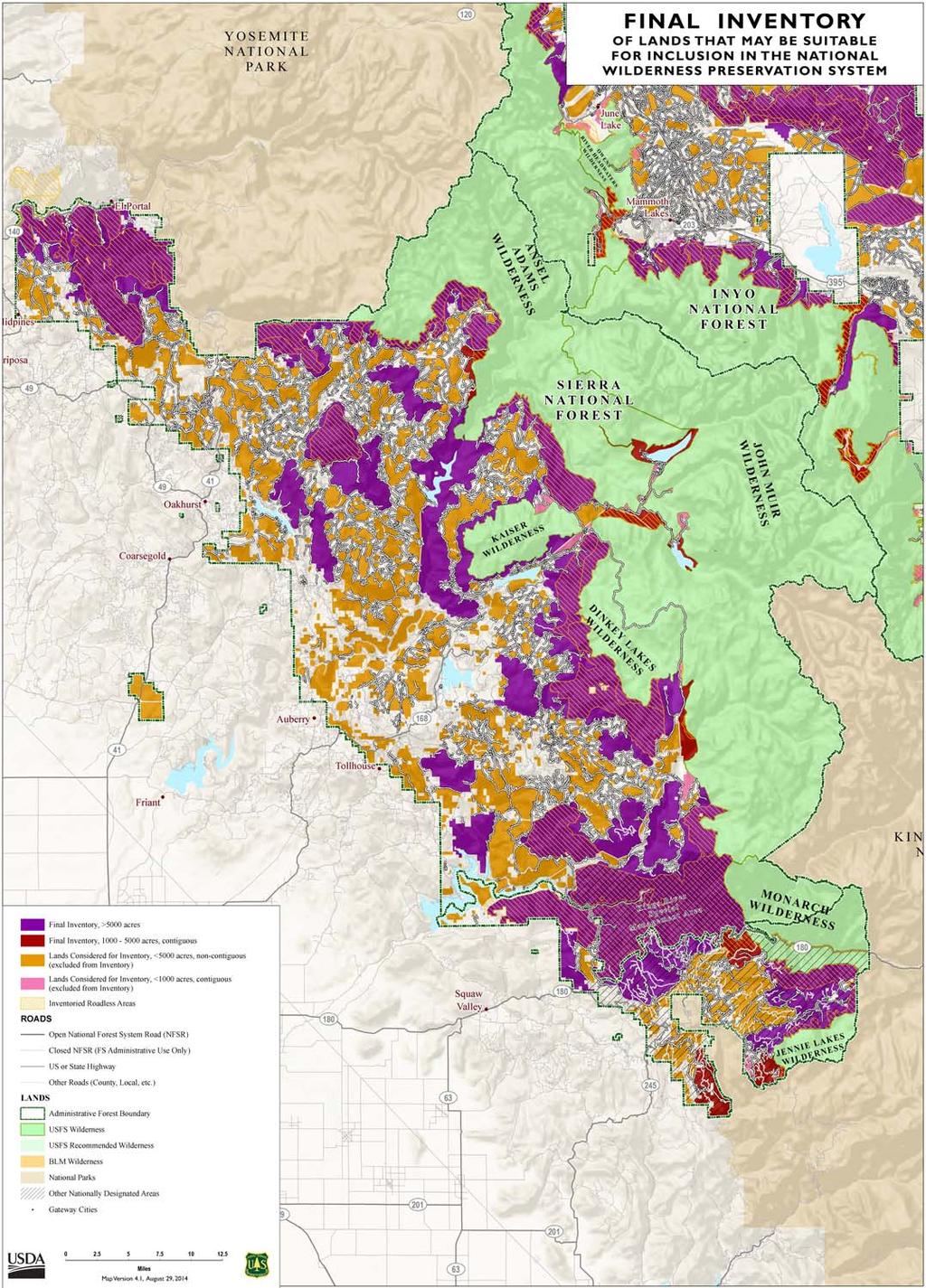
3
 and assigned inventoried areas into polygons that it could evaluate for wilderness")
4 Figure 2 Close Up of above Map showing the Area in the Vicinity of the French Fire As the Sierra NF moved into the post-inventory phases, the Forest followed a methodical process (R5 Early Adopters Forest Plan Revision Summary of the Wilderness Evaluation Step Documentation of the Process, see Appendix B) and assigned inventoried areas into polygons that it could evaluate for wilderness character. The French Fire Recovery and Restoration Project overlaps on the edges of two of these polygons, as shown in Figures 3 & 4 below. During September through mid-december of 2014, each R5 early adopter forest began a detailed evaluation of the wilderness characteristics and manageability 1 of each area in the inventory. See 1 Manageability is defined as the ability of the Forest Service to manage an area as wilderness considering such factors as size, shape, and juxtaposition to external influences. See 4
5 Appendix A of this analysis for the explanation of the wilderness evaluation process posted on the R5 Inyo, Sequoia and Sierra Forest Plan Revisions website section addressing Wilderness Inventory and Evaluation [ Currently the Sierra NF has also posted on the R5 website above two areas that the Forest will evaluate as recommended wilderness in at least one alternative for the Sierra Forest Plan. These two areas total 35,990 acres, and they are both more than approximately 9 miles away from the Project area. The Sierra NF is currently considering and is likely to add additional wilderness polygons or portions of those polygons to its recommendation in one or more alternatives in Forest Plan Revision for the Sierra NF. In analyzing the French Fire Recovery and Restoration Project, the Forest reviewed the wilderness evaluation it is currently undertaking. The Forest has concluded that it is not likely to consider for wilderness inclusion in any Forest Plan Revision the portions of the polygons that overlap with French Project treatment units, because the two polygons either lack of wilderness character, are not manageable, or both. The Forest does not reasonably foresee designating those areas as wilderness in the foreseeable future. Effect of the Project on Wilderness Character To determine the effects of the French Project on wilderness character, the Forest looked at the effects on both designated wilderness and potential wilderness. As the project does not overlap any currently designated wilderness, the French Project does not affect wilderness character in existing wilderness areas. Inventoried potential wilderness areas 2 identified as part of the forest plan revision process have no official designation and no special management direction or other requirements apply to these areas. Nonetheless, the Forest has reviewed the impacts of the Project on the inventoried polygons in the French Fire area to determine whether they have wilderness character potential and whether the Forest Service would likely designate them as wilderness in the future. The Forest has not completed its currently ongoing process for identifying wilderness character of inventoried polygons. The final inventory map released by the Sierra NF as part of plan revision does not reflect the polygons, either. To ascertain the potential impact of the Project most conservatively, our analysis overlaid the Project treatment units onto the final wilderness inventory maps, and found that 142 acres of inventoried potential wilderness acres overlap Project treatment units. See Figures 3 & 4. Table 1 identifies the treatments the French Project contractor will complete on these 142 acres 2 Inventoried potential wilderness areas are defined as areas identified as part of the potential wilderness inventory conducted as part of plan revision. They have no correlation to areas that may be designated as Inventoried Roadless Areas under the Roadless Rule. 5

6 Figure 3 Final Wilderness Inventory Map with French Fire Treatment Units Overlain 6

7 Figure 4 Close Up of above Map showing the French Fire Treatment Units 7
8 Table 1 Acreages of French Treatment Units Overlapping in Wilderness Inventory Map Areas of Final Inventory >5,000 acres Acres What Map_Symbol 4.08 Plantation Purple 0.02 Plantation Purple 0.01 Plantation Purple Plantation Purple 3.99 Plantation Purple FirstEntryUnit Purple FirstEntryUnit Purple 9.69 Outer 150' Road Purple Haz Outer 150' Road Purple Haz DFPZ 75ft Buff Purple DFPZ 75ft Buff Purple DFPZ 75ft Buff Purple TOTAL ACRES 8
")
9 Figure 5 West side of French Fire Project Treatment Units (81 acres) 9
 because it needs to maintain a strategic line for safely fighting wildfire.")
10 Figure 6 Eastside of the French Fire Project Treatment Units 61 acres The Forest has determined that it needs to implement the French Project, in part, to treat the DFPZs in the inventoried area (54.3 acres) because it needs to maintain a strategic line for safely fighting wildfire. These DFPZs already exist on the landscape, showing human influence on the landscape and reducing their potential wilderness character. Treating DFPZs manages vegetation re-growth and fuel loading to provide fire managers the needed anchor points and safe locations to engage future wildfires. DFPZs have been identified in existing pre-attack planning maps and were used during the suppression of the 2013 Aspen fire and the 2014 French fire. The contractor will treat the plantations located in the inventoried areas (24.24 acres) where one can already see prior human influence in the regular plantation planting patterns. That makes them unlikely to exhibit wilderness character. The Project also treats roadside hazard trees within or close to roaded areas. Hazard trees could fall on the roads and could trap users or even strike them directly. Likely, since these areas are close to roads with its associated motorized use, the Forest will again screen those areas out of any future wilderness proposal because they would not exhibit wilderness character. Even if the 10
11 Forest identifies those areas as exhibiting wilderness character, the Forest would want to remove those hazards along the roadways to mitigate the public safety risk. Beyond the human manipulation that has occurred in these areas prior to the French fire, other characteristics compromise their wilderness character. The Forest has identified some of these characteristics as it has been completing its Forest Plan Revision. Within the French Fire boundary, the Forest found the following characteristics that compromise their wilderness character: On the west side of the Project treatment area (Fig. 5), the southern portion of the inventoried polygon was directly impacted by the French Fire itself, with remnants from fire suppression actions present on the landscape, including direct and indirect fire line construction, both hand and mechanical. Similarly, on the east side of the Project treatment area (Fig. 6), which falls within the San Joaquin River canyon, the wilderness characteristics of the area are significantly compromised by surrounding development and extensive fire suppression impacts. Conclusion The Project is not impacting any existing designated wilderness, or any portions of inventoried potential wilderness polygons that are currently proposed or likely to be proposed for wilderness inclusion in an alternative in the Sierra NF s Forest Plan Revision DEIS. Therefore, it is not reasonably foreseeable that the Forest would include any areas within the French Fire boundary as potential wilderness. Beyond the Wilderness Act, no law, policy, or regulation requires the Forest Service to manage inventoried potential wilderness areas in any particular way. Even if one did, the Project only intersects with inventoried potential wilderness areas on 142 acres (0.01% of the Forest). Of those 142 acres, most (75%) are in areas already that humans have already impacted, and those impacts have degraded the areas wilderness character, or are in areas that require human intervention for public safety. The Sierra NF s preliminary wilderness evaluation indicates that all of the 142 acres of treatment units are within areas where active fire suppression has recently occurred, showing clear signs of human manipulation which further degrades their potential wilderness character. The Project will treat areas that do not have sufficient wilderness character or manageability for the Forest to recommend as wilderness during the Forest Plan Revision process. Based on the above analysis, the Project activities would have minimal impact on wilderness character or the potential to designate new wilderness and it is not reasonably foreseeable that Project areas intersecting with inventoried potential wilderness will be included in the future as recommended wilderness. Moreover, while I have concluded that the two affected portions of the inventoried polygons are unlikely to be included in a wilderness recommendation at this time because they lack wilderness character, even if the larger areas were subsequently found to have the requisite wilderness characteristics in the future, any resulting wilderness recommendation could redraw the proposed wilderness boundaries to excise the 142 acres treated with no loss to the remaining area s 11

12
13 Appendix A Wilderness Inventory and Evaluation Process for Forest Plan Revision (Forest Service Pacific Southwest Regional Office Wilderness Inventory and Evaluation website The following outline describes the steps and criteria we will use to identify and evaluate lands on the Inyo, Sequoia, and Sierra National Forests that may be suitable for inclusion in the NWPS and determine whether to recommend any such lands for wilderness designation. The process is based on the direction found in the draft, FACA-edited version of the revised Forest Service Handbook (FSH) , Chapter 70. There are four primary steps in the process: Inventory, Evaluation, Analysis and Decision. Inventory During inventory, National Forest System (NFS) lands that meet the size and improvements criteria outlined in Section 71 of Chapter 70 will be identified. We will use the following process to develop the inventory: 1. Identify all lands that meet the Roads Improvements criteria, as outlined in Ch. 70, 71.22(a). 2. Exclude lands that meet the Roads Improvements criteria but have less than half a mile across between roads, because they are not of sufficient size as to make practicable their preservation and use in unimpaired condition. 3. Identify and exclude lands that meet the Roads improvements criteria but have power lines with cleared right-of-ways, pipelines, and other permanently installed linear right-of-way structures. This step is based on Ch. 70, (b) (9). 4. Create a draft preliminary inventory map based on the above steps, identifying polygons in the following categories: a. Areas that are 5000 acres or greater. b. Areas less than 5000 acres and non-contiguous to existing designated wilderness, primitive areas, and recommended wilderness on both NFS lands and adjacent lands of other Federal ownership. c. Areas between 1000 and 4999 acres and contiguous to existing designated wilderness, primitive areas, and recommended wilderness on both NFS lands and adjacent lands of other Federal ownership. d. Areas less than 1000 acres and contiguous to existing designated wilderness, primitive areas, and recommended wilderness on both NFS lands and adjacent lands of other Federal ownership. 5. Include areas greater than 5000 acres, both contiguous and non-contiguous. This step is based on the size criteria described in Ch. 70, (1). 6. Include areas that are between 1000 and 4999 acres and contiguous with existing designated wilderness, primitive areas, and recommended wilderness on both NFS lands and adjacent lands of other Federal ownership. This step is based on the size criteria described in Ch. 70, (3). 7. Review areas less than 5000 acres that are not contiguous to existing designated wilderness, primitive areas, and recommended wilderness on both NFS lands and adjacent lands of other federal ownership. Unless the Forest determines that these areas are of sufficient size as to make practicable their preservation and use in an unimpaired condition and are able to be managed as a separate unit of the NWPS, Last updated: 6/6/
14 they will be excluded. This step is based on the criteria described in Ch. 70, (3). 8. Review areas that are less than 1000 acres and contiguous to existing designated wilderness, primitive areas, and recommended wilderness on both NFS lands and adjacent lands of other Federal ownership. Unless it is determined that these areas are practicable additions in shape and size, they will be excluded. 9. Identify and exclude any improvements in the polygons that clearly do not meet the criteria in Ch. 70, 71.22(b). 10. Create an updated preliminary inventory map based on the above steps. 11. Share the preliminary inventory map and a description of the inventory process with the public and tribes. 12. Collect feedback from the public and tribes on the preliminary inventory and any citizen inventory proposals. At the discretion of the responsible official (Forest Supervisor), the preliminary inventory may be modified based on feedback received. Modifications may include: a. Eliminating areas based on new information. b. Adding areas based on new information. c. Reshaping areas based on new information. 13. Create a final inventory map and share with the public and tribes. Evaluation The primary function of the evaluation process is to evaluate the wilderness characteristics of each area identified during inventory. We will use the following process: 1. Identify authorized motorized trails and prepare maps that overlay authorized motorized trails on the final inventory maps. 2. For each area in the inventory, examine the extent of authorized and maintained motorized trails. Make recommendations on whether to eliminate the area from further consideration, to eliminate a portion of the area and reshape it to exclude authorized motorized trails, or continue to evaluate the whole area. These recommendations will be presented to the responsible official who will make the final decision on what to carry forward for evaluation. This early evaluation step is based on the criteria found in Ch. 70, 72.1 (5). 3. Create new maps of areas to carry forward in the evaluation, reflecting any changes resulting from the above steps, and make these maps available to the public and tribes. 4. Using forest interdisciplinary teams (IDTs), evaluate each area for its wilderness potential based on the wilderness evaluation criteria found in Ch. 70, These criteria will be addressed in narrative format using a wilderness evaluation template. 5. Use the wilderness evaluation criteria narratives to write a summary of wilderness character for each area evaluated. 6. Prepare a document of the evaluation of areas that may be suitable for inclusion in the NWPS, and include the following: a. A description of the identification, inventory and evaluation process. b. Narrative descriptions of each area evaluated. Last updated: 6/6/
15 c. A summary of the wilderness character for each area evaluated. d. Large scape maps of the evaluated areas. 7. Include this information as an appendix to the Draft Environmental Impact Statement (DEIS). The appendix will be available for public review during the DEIS comment period. Analysis We will use the following process for the analysis: 1. Present the evaluation document, public input, and staff recommendations to the responsible officials for their review. Responsible officials will identify which specific areas, or portions thereof, to carry forward into the National Environmental Policy Act (NEPA) analysis in one or more alternatives. Not all lands included in the inventory and subsequent evaluations are required to be carried forward in an alternative. 2. For areas that will be carried forward into the NEPA document, include the minimum documentation described in Ch. 70, 73. This includes cleaning up boundaries using the guidelines contained in Ch. 70. Produce updated maps reflecting the boundary updates, as well as overview maps. 3. Develop plan components for areas recommended for wilderness designation that protect and maintain the ecological and social characteristics that provide the basis for their suitability for wilderness designation. 4. The responsible official will document his/her rationale for why areas were not carried forward into the NEPA process as part of one or more alternatives. 5. Adjustments may be made to alternatives between the DEIS and FEIS in response to public comments. Decision Based on the NEPA analysis, the responsible official will make a decision on specific areas to recommend for inclusion in the NWPS. The decision will be included in the final decision document as a preliminary administrative recommendation." Wilderness Evaluation Process Also from the R5 website listed above clicking on Evaluation As a first step in the evaluation process, we identified authorized motorized trails on the final inventory maps. Areas with authorized motorized trails were examined and determined to lack wilderness character due to the prevalence of authorized motorized activity and its impacts to the surrounding area. Additionally, there is a high level of commitment to maintaining these authorized motorized trails. As a result, each forest identified areas within the inventory where wilderness characteristics are impacted by the authorized motorized trail system and highlighted these portions of the inventory (about 19%). Each area was evaluated as a whole, but the focus for the detailed evaluation was on the portions of the inventory that do not contain authorized motorized trails (remaining 81%). 15
16 The Forest Service posted the map of areas to be evaluated in detail on a collaborative mapping website, called Talking Points and invited participation in the evaluation process by asking the public to provide any information that would be helpful as we evaluated the factors that contribute to the wilderness characteristics of each area As described in the 2005 USDA Forest Service Rocky Mountain Research Station publication Monitoring Selected Conditions Related to Wilderness Character: A National Framework, wilderness character includes the following five qualities: Untrammeled wilderness is essentially unhindered and free from modern human control or manipulation. Natural wilderness ecological systems are substantially free from the effects of modern civilization. Undeveloped wilderness is essentially without permanent improvements or evidence of modern human occupation. Outstanding opportunities for solitude or a primitive and unconfined type of recreation wilderness provides outstanding opportunities for people to experience solitude or primitive and unconfined recreation, including the values of inspiration and physical and mental challenge. Unique qualities of a particular wilderness area other features of value such as ecological, geological or other features of scientific, educational, or scenic value that are unique to a particular wilderness area. During the wilderness evaluation, the Inyo, Sequoia and Sierra National Forests also held a formal 30-day scoping period on the proposed action to revise the existing forest plans for each of these forests. Scoping guides the development of the environmental impact statement (EIS). All comments received, through both the Talking Points website and during scoping that had information regarding the relative wilderness characteristics of each area were considered by each forest. Using the criteria in Forest Service Handbook Chapter 70, 72.1,each forest evaluated all lands identified in the inventory to determine potential suitability for inclusion in the National Wilderness Preservation System. In addition to the information provided by the public and the tribes, the Forests gathered and documented the existing condition of all of the factors that contribute to each of the criteria. Next, this information was summarized into a narrative evaluation for each area. Each wilderness evaluation narrative includes: A general description of the area; A description of the area s wilderness characteristics including; o The degree to which the area generally appears to be affected primarily by the forces of nature including the current condition of the natural and undeveloped characteristics of the area. o Opportunities for solitude of primitive and unconfined recreation o Other features of value including any high value, special, rare, or unique resources identified by the specialists that contributes to the wilderness character of the particular area (i.e. SN Bighorn Sheep, unique geology, rare or unique heritage resources. A description of factors that affect the manageability of the area (i.e. adjacent land uses, non-conforming established rights and uses, inholdings, incompatible recreation activities (i.e. mtn. biking), overlapping designations, shape, etc. A summary of the factors that affect the area s potential suitability for inclusion in the NWPS based on the wilderness characteristics and potential manageability of the area as wilderness, including any other key factors that will assist the decision maker in understanding the suitability of the area for recommendation as wilderness (i.e. provides critical connectivity, is 16
17 an ecosystem type that is not yet or is underrepresented in the NWPS, provides opportunities for restoration, etc.) The Forest Service is compiling the results of the wilderness inventory and evaluation into one document that will be included as an appendix in the draft EIS and will be available for public review during the draft EIS comment period. Forest Supervisors will use the wilderness evaluation narratives and public input to identify which specific areas, or portions thereof, to carry forward into the draft EIS analysis in one or more alternatives as recommended wilderness. Not all lands included in the inventory and subsequent evaluations are required to be carried forward in an alternative. A detailed boundary map and a narrative description has been prepared for each recommended area that will be analyzed in the DEIS. R5 website 17
18 Appendix B Need for DFPZs and their Interrelationship with the Project Manage Fuel Loadings within Defensive Fuel Profile Zones (DFPZ s) in Strategic Topographic Locations There is a need to manage vegetation re-growth and fuel loading in identified DFPZ s to provide fire managers the needed anchor points and safe locations to engage future wildfires. DFPZ s have been identified in existing pre-attack planning maps and used during the suppression of the 2013 Aspen fire and the French fire. In these areas, fire-affected trees fall to the ground and become down woody material and vegetation regrowth of shrubs would create hazardous live and dead surface fuel conditions inhibiting effective fire management in the future. Managed DFPZ s are also needed to help protect the established reforested areas in the event of another fire, while the planted trees are more vulnerable at a younger age. (EA Section ) Create and Maintain DFPZ s in Strategic Locations to Help Manage Future Wildfires. Fuels treatment and maintenance would occur on approximately 221 acres within existing and proposed DFPZ s, 126 acres overlap with other treatments. These areas are 150 feet wide and are located along dominant ridges and terrain features. (EA Section ) 18
WORKSHEET 1 Wilderness Qualities or Attributes Evaluating the Effects of Project Activities on Wilderness Attributes
 WORKSHEET 1 Wilderness Qualities or Attributes Evaluating the Effects of Project Activities on Wilderness Attributes Date: 3/7/2017 Roadless Area: Ruby South Description of Project Activity or Impact to
Wilderness Character and Wilderness Characteristics. What s the difference? Why does it matter?
 Introduction Wilderness Character and Wilderness Characteristics What s the difference? Why does it matter? The terms wilderness character and wilderness characteristics are sometimes used interchangeably
WILDERNESS PLANNING. Wilderness. Interagency Regional Wilderness Stewardship Training. Alamosa, Colorado - March 26-29, 2007
 WILDERNESS PLANNING Interagency Regional Wilderness Stewardship Training Alamosa, Colorado - March 26-29, 2007 Suzanne Stutzman Lead Planner/Wilderness Coordinator National Park Service, Intermountain
Expanding Settlement Growing Mechanization
 The Wilderness Act of 1964 Expanding Settlement Growing Mechanization Versus Wilderness protection is paper thin, and the paper should be the best we can get that upon which Congress prints its Acts. David
Wilderness Process #NP-1810: Your letter ID is NP September 5, 2018
 Wilderness Process #NP-1810: Your letter ID is NP-1810-2602-96 September 5, 2018 RE: GMUG Wilderness Evaluation Revised Evaluation Criteria and Draft Report Forest Revision Planning Team: The Continental
/s/ Robert V. Abbey Director
 Form 1221-2 (June 1969) UNITED STATES DEPARTMENT OF THE INTERIOR BUREAU OF LAND MANAGEMENT MANUAL TRANSMITTAL SHEET Release 6-129 Date 03/15/2012 Subject 6310 Conducting Wilderness Characteristics Inventory
Decision Memo Broken Wheel Ranch Equestrian Outfitter Special-Use Permit Proposed Action
 Decision Memo Broken Wheel Ranch Equestrian Outfitter Special-Use Permit USDA Forest Service Mississippi Bluffs Ranger District, Shawnee National Forest Jackson and Union Counties, Illinois Proposed Action
TONGASS NATIONAL FOREST
 TONGASS NATIONAL FOREST UNITED STATES DEPARTMENT OF AGRICULTURE-FOREST SERVICE Contact: Dennis Neill Phone: 907-228-6201 Release Date: May 17, 2002 SEIS Questions and Answers Q. Why did you prepare this
Arthur Carhart National Wilderness Training Center s Wilderness Investigations High School
 Arthur Carhart National Training Center s Investigations High School 101/Lesson 2 (OPTION 2B) Introducing the Act Goal: Students will understand the difference between wild spaces and federally designated
RE: Access Fund Comments on Yosemite National Park Wilderness Stewardship Plan, Preliminary Ideas and Concepts
 September 30, 2016 Superintendent Yosemite National Park Attn: Wilderness Stewardship Plan P.O. Box 577 Yosemite, CA 95389 RE: Access Fund Comments on Yosemite National Park Wilderness Stewardship Plan,
Draft Revised Land Management Plan and DEIS Comments
 December 28, 2017 Dan Dallas, Forest Supervisor Rio Grande National Forest Attn: Rio Grande Forest Plan Revision 1803 W. U.S. Highway 160 Monte Vista, CO 81144 rgnf_forest_plan@fs.fed.us Draft Revised
MONTEREY REGIONAL AIRPORT MASTER PLAN TOPICAL QUESTIONS FROM THE PLANNING ADVISORY COMMITTEE AND TOPICAL RESPONSES
 MONTEREY REGIONAL AIRPORT MASTER PLAN TOPICAL QUESTIONS FROM THE PLANNING ADVISORY COMMITTEE AND TOPICAL RESPONSES Recurring topics emerged in some of the comments and questions raised by members of the
Wilderness Stewardship Plan Scoping Newsletter Winter 2013
 Olympic National Park National Park Service U.S. Department of the Interior Wilderness Stewardship Plan Scoping Newsletter Winter 2013 Dear Friends and Neighbors, The Olympic Wilderness was established
Overview. Wilderness Act of Statement of Need. What is Wilderness Character. Monitoring Wilderness Character
 Overview Monitoring Wilderness Character What What & Why? How? How? Conceptual Development How? How? Implementation Future? Future? Troy Hall Steve Boutcher USFS Wilderness & Wild and Scenic River Program
Connie Rudd Superintendent, Black Canyon of the Gunnison National Park
 National Park Service U.S. Department of the Interior Black Canyon of the Gunnison National Park and Curecanti National Recreation Area Information Brochure #1 Wilderness and Backcountry Management Plan
Continental Divide National Scenic Trail Legislative History and Planning Guidance
 Continental Divide National Scenic Trail Legislative History and Planning Guidance Legislation, Policy, and Direction Regarding National Scenic Trails The National Trails System Act, P.L. 90-543, was passed
Daisy Dean Trail 628/619 ATV Trail Construction
 Background and Purpose and Need The Daisy Dean ATV Trail Construction Project is located in the Little Belt Mountains, Musselshell Ranger District, Lewis and Clark National Forest approximately 32 miles
Wilderness Stewardship Plan Handbook
 National Park Service U.S. Department of the Interior Wilderness Stewardship Program Wilderness Stewardship Plan Handbook Planning to Preserve Wilderness Character DRAFT April 2012 Wilderness Stewardship
Final Environmental Impact Statement for the Merced Wild and Scenic River. Comprehensive Management Plan, Yosemite National Park, Madera and Mariposa
 This document is scheduled to be published in the Federal Register on 02/26/2014 and available online at http://federalregister.gov/a/2014-04061, and on FDsys.gov DEPARTMENT OF THE INTERIOR 4312-FF NATIONAL
White Mountain National Forest Saco Ranger District
 United States Department of Agriculture Forest Service White Mountain National Forest Saco Ranger District 33 Kancamagus Highway Conway, NH 03818 Comm: (603) 447-5448 TTY: (603) 447-3121 File Code: 1950
Minimum Requirements References in National Park Service Policy
 Minimum Requirements References in National Park Service Policy 2006 NPS Management Policies Chapter 6: Wilderness Preservation and Management 6.3 Wilderness Resource Management 6.3.1 General Policy (in
BACKCOUNTRY TRAIL FLOOD REHABILITATION PROGRAM
 BACKCOUNTRY TRAIL FLOOD REHABILITATION PROGRAM Backcountry Trail Flood Rehabilitation A June 2013 Flood Recovery Program Summary In June 2013, parts of Southern Alberta were devastated from significant
Appendix I. Wilderness Review
 Appendix I. Wilderness Review This appendix contains the wilderness inventory conducted for the Ash Meadows, Moapa Valley, and Pahranagat National Wildlife Refuges (NWRs) as part of the Comprehensive Conservation
3.12 Roadless Areas and Unroaded Areas
 3.12 Roadless Areas and Unroaded Areas Introduction This analysis focuses on the direct and indirect effects of activities proposed in the Como Forest Health project on roadless area values, including
National Park Service Wilderness Action Plan
 National Park Service U.S. Department of the Interior National Park Service Wilderness Action Plan National Wilderness Steering Committee National Park Service "The mountains can be reached in all seasons.
RECREATION. Seven issues were identified that pertain to the effects of travel management on outdoor recreation within portions of the project area.
 RECREATION Seven issues were identified that pertain to the effects of travel management on outdoor recreation within portions of the project area. OPPORTUNITIES FOR SOLITUDE / QUIET TRAILS. One attraction
White Mountain National Forest Saco Ranger District
 United States Department of Agriculture Forest Service White Mountain National Forest 33 Kancamagus Highway Conway, NH 03818 Comm: (603) 447-5448 TTY: (603) 447-3121 File Code: 1950 Date: February 26,
Bradley Brook Relocation Project. Scoping Notice. Saco Ranger District. United States Department of Agriculture Forest Service
 Bradley Brook Relocation Project United States Department of Agriculture Forest Service Scoping Notice White Mountain National Forest February 2011 For Information Contact: Jenny Burnett White Mountain
DECISION MEMO. Rawhide Trail #7073 Maintenance and Reconstruction
 Page 1 of 6 Background DECISION MEMO USDA Forest Service Jefferson Ranger District Jefferson County, Montana Rawhide Trail #7073 is located in the Elkhorn Mountain Range approximately 10 miles east of
S Central Coast Heritage Protection Act APRIL 21, 2016
 STATEMENT OF GLENN CASAMASSA ASSOCIATE DEPUTY CHIEF, NATIONAL FOREST SYSTEM U.S. FOREST SERVICE U.S. DEPARTMENT OF AGRICULTURE BEFORE THE UNITED STATES SENATE COMMITTEE ON ENERGY AND NATURAL RESOURCES
As required by 36 C.F.R (d), objectors provide the following information:
, objectors provide the following information:") May 12, 2014 Objection Reviewing Officer USDA Forest Service, Northern Region P.O. Box 7669 Missoula, MT 59807 Dear Objection Reviewing Officer: This letter serves as The Wilderness Society s ( TWS ) objection
May 12, 2014 Objection Reviewing Officer USDA Forest Service, Northern Region P.O. Box 7669 Missoula, MT 59807 Dear Objection Reviewing Officer: This letter serves as The Wilderness Society s ( TWS ) objection
RIM TRAIL EXTENSION PROJECT
 DECISION MEMO For RAINBOW RIM TRAIL EXTENSION PROJECT Located on National Forest System Lands USDA Forest Service, Southwest Region Kaibab National Forest - North Kaibab Ranger District T.35 N, R.1 E,
112th CONGRESS. 1st Session H. R. 113 IN THE HOUSE OF REPRESENTATIVES
 HR 113 IH 112th CONGRESS 1st Session H. R. 113 To provide for additions to the Cucamonga and Sheep Mountain Wilderness Areas in the Angeles and San Bernardino National Forests and the protection of existing
Creating a User-Driven Long-Distance OHV Trail Through Partnering
 Joseph Raffaele Outdoor Recreation Planner U.S. Bureau of Land Management Yuma, Arizona Creating a User-Driven Long-Distance OHV Trail Through Partnering BLM is a multiple-use land management agency within
St. Joe Travel Management EA CULTURAL RESOURCES
 St. Joe Travel Management EA CULTURAL RESOURCES Bruce Gibson May 2015 Regulatory Framework Forest Plan The Idaho Panhandle National Forests (IPNF) Forest Plan requires systematic cultural resource inventory
Tahoe National Forest Over-Snow Vehicle Use Designation
 Tahoe National Forest Over-Snow Vehicle Use Designation USDA Forest Service Tahoe National Forest February 20, 2015 Introduction The Forest Service, U.S. Department of Agriculture will prepare an Environmental
Chetco River Kayaking Permit
 Decision Memo USDA Forest Service Rogue River-Siskiyou National Forest Gold Beach Ranger District - Curry County, Oregon Wild Rivers Ranger District Josephine County, Oregon BACKGROUND A special use permit
Special Recreation Management Areas Extensive Recreation Management Areas Public Lands Not Designated as Recreation Management Areas
 From the Proposed RMP: Special Recreation Management Areas SRMAs are an administrative unit where the existing or proposed recreation opportunities and recreation setting characteristics are recognized
National Wilderness Steering Committee
 National Wilderness Steering Committee Guidance White Paper Number 1 Issue: Cultural Resources and Wilderness Date: November 30, 2002 Introduction to the Issue Two of the purposes of the National Wilderness
Establishing a National Urban Park in the Rouge Valley
 STAFF REPORT ACTION REQUIRED Establishing a National Urban Park in the Rouge Valley Date: March 29, 2012 To: From: Wards: Reference Number: Executive Committee Deputy City Manager, Cluster B All p:\2012\cluster
Final General Management Plan/Wilderness Study/Environmental Impact Statement:
 This document is scheduled to be published in the Federal Register on 03/11/2016 and available online at http://federalregister.gov/a/2016-05542, and on FDsys.gov DEPARTMENT OF THE INTERIOR 4312-FF National
Securing Permanent Protection for Public Land
 Securing Permanent Protection for Public Land Tools for Wyoming Advocates Paul Spitler* The Wilderness Society * I am a wilderness policy expert, not a powerpoint expert! Platform and Resolutions of the
CHAPTER 1: INTRODUCTION
 CHAPTER 1: INTRODUCTION Purpose and Scope The information presented in this report represents the study findings for the 2016 Ronan Airport Master Plan prepared for the City of Ronan and Lake County, the
REC 22 WILDERNESS AREAS
 REC 22 WILDERNESS AREAS 1.0 EXECUTIVE SUMMARY This study focuses on recreational use associated with four designated Wilderness areas in the Southern California Edison (SCE) Big Creek Alternative Licensing
PROUDLY BRINGING YOU CANADA AT ITS BEST. Management Planning Program NEWSLETTER #1 OCTOBER, 2000
 PROUDLY BRINGING YOU CANADA AT ITS BEST VUNTUT NATIONAL PARK Management Planning Program NEWSLETTER #1 OCTOBER, 2000 INTRODUCTION This newsletter launches the development of the first management plan for
Alternative 3 Prohibit Road Construction, Reconstruction, and Timber Harvest Except for Stewardship Purposes B Within Inventoried Roadless Areas
 Roadless Area Conservation FEIS Summary Table S-1. Comparison of Key Characteristics and Effects by Prohibition Alternative. The effects summarized in this table A would occur in inventoried roadless areas
April 10, Mark Stiles San Juan Public Lands Center Manager 15 Burnett Court Durango, CO Dear Mark,
 Mark Stiles San Juan Public Lands Center Manager 15 Burnett Court Durango, CO 81301 Dear Mark, We are pleased to offer the following comments on the draft San Juan Public Lands Center management plans
Douglas Smith, District Ranger ATTN: Hi Lo Project Kawishiwi Ranger Station 1393 Hwy 169 Ely, MN 55731
 Board of Directors Gary Macfarlane, ID President Franz Camenzind, WY Vice-President Marty Almquist, MT Secretary-Treasurer Talasi Brooks, ID Louise Lasley, NM Cyndi Tuell, AZ René Voss, CA Senior Advisor
1803 West Hwy 160 Monte Vista, CO (719) TTY (719)
 TTY (719)") USDA Forest Service Rio Grande National Forest http://www.fs.fed.us/r2/riogrande 1803 West Hwy 160 Monte Vista, CO 81144 (719)852-5941 TTY (719)852-6271 USDI Bureau of Land Management San Luis Valley Center
USDA Forest Service Rio Grande National Forest http://www.fs.fed.us/r2/riogrande 1803 West Hwy 160 Monte Vista, CO 81144 (719)852-5941 TTY (719)852-6271 USDI Bureau of Land Management San Luis Valley Center
Figure 1-Example of terracing from livestock
 To: District Ranger Matt Janowiak April 3, 2016 P.O. Box 439, Bayfield, CO 81122 comments-rocky-mountain-san-juan-columbine@fs.fed.us From: Greg Warren Golden, CO 80401 Please consider the following comments
Decision Memo for Desolation Trail: Mill D to Desolation Lake Trail Relocation
 for Salt Lake County, Utah Uinta-Wasatch-Cache National Forest Salt Lake Ranger District 1. Background The present location of the Desolation Trail (#1159) between Mill D and Desolation Lake follows old
David Johnson. Tom, Attached please find the final scoping letter and figures for your review. David
 David Johnson From: Sent: To: Cc: Subject: Attachments: David Johnson Tuesday, April 12, 2011 4:33 PM Thomas Malecek Dave Dyer; Jason Marks (jmarks@segroup.com) VWC Scoping Letter
Wilderness Research. in Alaska s National Parks. Scientists: Heading to the Alaska Wilderness? Introduction
 Wilderness Research in Alaska s National Parks National Park Service U.S. Department of Interior Scientists: Heading to the Alaska Wilderness? Archeologist conducts fieldwork in Gates of the Arctic National
MINIMUM REQUIREMENTS DECISION GUIDE WORKSHEETS
 ARTHUR CARHART NATIONAL WILDERNESS TRAINING CENTER MINIMUM REQUIREMENTS DECISION GUIDE WORKSHEETS Prescribed burning of islands within Okefenokee Wilderness Area.... except as necessary to meet minimum
MEETING MINUTES Page 1 of 5
 Page 1 of 5 50178.000 May 26, 2009 PROJECT PROJECT NO. MEETING DATE ISSUE DATE Citizens Advisory Committee Meeting MEETING LOCATION MEETING PURPOSE Amy Eckland ISSUED BY SIGNATURE PARTICIPANT See attached
The Wilderness Act of Cecilia Reed, Forest Service Mokelumne Wilderness Manager
 The Wilderness Act of 1964 Cecilia Reed, Forest Service Mokelumne Wilderness Manager Aldo Leopold Arthur Carhart Teddy Roosevelt The Wilderness Act of 1964 After much debate and compromise after 66 drafts,
Wallowa Falls Hydroelectric Project FERC Project No. P-308 Proposed Study Plans - Recreation August 2011
 Wallowa Falls Hydroelectric Project FERC Project No. P-308 August 2011 Prepared by: PacifiCorp Energy Hydro Resources 825 NE Multnomah, Suite 1500 Portland, OR 97232 For Public Review Wallowa Falls Hydroelectric
Terms of Reference: Introduction
 Terms of Reference: Assessment of airport-airline engagement on the appropriate scope, design and cost of new runway capacity; and Support in analysing technical responses to the Government s draft NPS
JOSLIN FIELD, MAGIC VALLEY REGIONAL AIRPORT DECEMBER 2012
 1. Introduction The Federal Aviation Administration (FAA) recommends that airport master plans be updated every 5 years or as necessary to keep them current. The Master Plan for Joslin Field, Magic Valley
Coconino National Forest Potential Wilderness Proposal
 Coconino National Forest Potential Wilderness Proposal As part of their Forest Plan Update, the Coconino National Forest needs to address the need for additional wilderness. The last evaluation was done
RUSHMORE CONNECTOR TRAIL PROPOSAL
 PURPOSE AND NEED Background The U.S. Forest Service, Black Hills National Forest (Forest Service) has received a special use permit application from the State of South Dakota Department of Game, Fish and
CHAPTER 6 NOISE EXPOSURE
 CHAPTER 6 NOISE EXPOSURE FAA requires that the NEM submitted for review represent the aircraft noise exposure for the year of submittal (in this case 2008) and for a future year (2013 for OSUA). However,
COMMISSION OF THE EUROPEAN COMMUNITIES. Draft. COMMISSION REGULATION (EU) No /2010
 No /2010") COMMISSION OF THE EUROPEAN COMMUNITIES Brussels, XXX Draft COMMISSION REGULATION (EU) No /2010 of [ ] on safety oversight in air traffic management and air navigation services (Text with EEA relevance)
COMMISSION OF THE EUROPEAN COMMUNITIES Brussels, XXX Draft COMMISSION REGULATION (EU) No /2010 of [ ] on safety oversight in air traffic management and air navigation services (Text with EEA relevance)
Decision Memo Ice Age Trail Improvement (CRAC 37)
") Decision Memo Ice Age Trail Improvement (CRAC 37) U.S. Forest Service Chequamegon-Nicolet National Forest, Medford-Park Falls Ranger District Taylor County, Wisconsin T32N, R2W, Town of Grover, Section
Decision Memo Ice Age Trail Improvement (CRAC 37) U.S. Forest Service Chequamegon-Nicolet National Forest, Medford-Park Falls Ranger District Taylor County, Wisconsin T32N, R2W, Town of Grover, Section
Wilderness. Air Tour Noise Assessment Framework George Wright Society April 2, 2015
 Wilderness Air Tour Noise Assessment Framework George Wright Society April 2, 2015 Judy Rocchio (presenter) Megan McKenna, Brent Lignell, Amanda Rapoza, Cyndy Lee, Vicki Ward Summary Wilderness Air Tour
Deer Creek. Forest Plan Special Designations and Inventoried Roadless Area Report. Prepared by: Dan Gilfillan North Zone Recreation Staff.
 Forest Plan Special Designations and Inventoried Roadless Area Report Prepared by: Dan Gilfillan North Zone Recreation Staff For: Bonner Ferry Ranger District Idaho Panhandle National Forest 8/28/2015
4/1/2009. Wilderness Character
 Monitoring Social Conditions in Wilderness Troy Hall March, 2009 CSS 490 Overview outstanding opportunities Indicators & data collection Data analysis 1 Wilderness Character Natural Untrammeled Undeveloped
With the first portion of this process complete, we anticipate the general timeline for the remainder of the process to be:
 THE CITY OF FIRE RESCUE E D M O N T O N FIRE RESCUE SERVICES 10351 96 Street Edmonton, Alberta T5H 2H5 April 19, 2013 Dear Rossdale residents: As many of you know, Fire Rescue Services is currently in
Proposed Action. Payette National Forest Over-Snow Grooming in Valley, Adams and Idaho Counties. United States Department of Agriculture
 United States Department of Agriculture Forest Service January 2012 Proposed Action Payette National Forest Over-Snow Grooming in Valley, Adams and Idaho Counties Payette National Forest Valley, Adams
Buffalo Pass Trails Project
 Buffalo Pass Trails Project Hahns Peak/Bears Ears Ranger District, Medicine Bow-Routt National Forests and Thunder Basin National Grassland Routt County, Colorado T6N 83W Sections 3-5, 8; T6N 84W Sections
Wilderness Areas Designated by the White Pine County bill
 Wilderness Areas Designated by the White Pine County bill SEC. 321. SHORT TITLE. This subtitle may be cited as the `Pam White Wilderness Act of 2006'. SEC. 322. FINDINGS. Congress finds that-- The White
Draft Environmental Impact Statement
 United States Department of Agriculture Forest Service Pacific Southwest Region Draft Environmental Impact Statement Inyo National Forest Motorized Travel Management R5-MB-182 January 2009 Inyo Mountains
Labrador - Island Transmission Link Target Rare Plant Survey Locations
 27-28- Figure: 36 of 55 29-28- Figure: 37 of 55 29- Figure: 38 of 55 #* Figure: 39 of 55 30- - east side Figure: 40 of 55 31- Figure: 41 of 55 31- Figure: 42 of 55 32- - secondary Figure: 43 of 55 32-
Recreation Opportunity Spectrum for River Management v
 Recreation Opportunity Spectrum for Management v. 120803 Introduction The following Recreation Opportunity Spectrum (ROS) characterizations and matrices mirror the presentation in the ROS Primer and Field
Chattahoochee- Oconee National Forests. Decision Memo
 Page 1 of 6 USDA Forest Service Chattahoochee- Oconee National Forests Decision Memo Chattahoochee-Oconee National Forests Home Page Recreation Information Forest History Forest Facts Forest Management
MINIMUM REQUIREMENTS DECISION GUIDE Instructions
 ARTHUR CARHART NATIONAL WILDERNESS TRAINING CENTER MINIMUM REQUIREMENTS DECISION GUIDE Instructions... except as necessary to meet minimum requirements for the administration of the area for the purpose
Project Planning, Compliance, and Funding
 Project Planning, Compliance, and Funding The plans above offer high level guidance to ensure that the A.T. is managed effectively as a whole unit in a decentralized management structure. Cooperative management
Fremont Point Cabin Reconstruction and Expansion Project Project Proposal & Public Scoping Documentation
 Fremont Point Cabin Reconstruction and Expansion Project Fremont-Winema National Forests Silver Lake Ranger District The Silver Lake Ranger District of the Fremont-Winema National Forests is proposing
Hermosa Area Preservation The Colorado Trail Foundation 4/11/2008
 Hermosa Area Preservation The Colorado Trail Foundation 4/11/2008 Legend d o Tr ail NPA - National Protection Area ra NCA - National Conservation Area o e C Th The Colorado Trail lo FS inventoried Roadless
2009 Muskoka Airport Economic Impact Study
 2009 Muskoka Airport Economic Impact Study November 4, 2009 Prepared by The District of Muskoka Planning and Economic Development Department BACKGROUND The Muskoka Airport is situated at the north end
Camping Freshwater Fishing Big Game Hunting VIII. Summary Decision
 Camping........ - 17 - Freshwater Fishing....... - 18 - Big Game Hunting........ - 19 - VIII. Summary Decision........ - 20 - Appendix 1 - Wilderness Management Direction. - 21 - The Wilderness Act of
MINIMUM REQUIREMENTS DECISION GUIDE WORKSHEETS
 ARTHUR CARHART NATIONAL WILDERNESS TRAINING CENTER MINIMUM REQUIREMENTS DECISION GUIDE WORKSHEETS Fuel Maintenance Around Red-cockaded Woodpecker Trees on Islands within the Okefenokee Wilderness Area....
Chapter 1 Introduction and Project Overview
 EPHRATA MUNICIPAL AIRPORT Chapter 1 Introduction and Project Overview The Port of Ephrata in cooperation with the Federal Aviation Administration (FAA) is updating the Airport Master Plan for Ephrata Municipal
UNITED STATES DEPARTMENT OF THE INTERIOR BUREAU OF LAND MANAGEMENT MANUAL TRANSMITTAL SHEET
 Form 1221-2 (June 1969) UNITED STATES DEPARTMENT OF THE INTERIOR BUREAU OF LAND MANAGEMENT MANUAL TRANSMITTAL SHEET Release 8-83 Date Subject 8353 Trail Management Areas Secretarially Designated (Public)
Decision Memo Sun Valley Super Enduro & Cross-Country Mountain Bike Race. Recreation Event
 Decision Memo 2015 Sun Valley Super Enduro & Cross-Country Mountain Bike Race Recreation Event USDA Forest Service Ketchum Ranger District, Sawtooth National Forest Blaine County, Idaho Background The
Alternatives. Introduction. Range of Alternatives
 Alternatives Introduction Federal environmental regulations concerning the environmental review process require that all reasonable alternatives, which might accomplish the objectives of a proposed project,
USCIS Announces First Ten Areas of Focus for Agency-wide Policy Review Public Survey Informs Selection Fact Sheet
 USCIS Announces First Ten Areas of Focus for Agency-wide Policy Review Public Survey Informs Selection Fact Sheet Introduction On April 15, 2010, U.S. Citizenship and Immigration Services (USCIS) launched
EMERY COUNTY PUBLIC LAND MANAGEMENT ACT OF 2018 S. 2809/H.R. 5727
 EMERY COUNTY PUBLIC LAND MANAGEMENT ACT OF 2018 S. 2809/H.R. 5727 September 25, 2018 OVERVIEW The Emery County Public Land Management Act of 2018 is a significant step backwards for wilderness and conservation
As outlined in the Tatshenshini-Alsek Park Management Agreement, park management will:
 Management Strategy General Strategy The priority management focus for the park is to ensure that its internationally significant natural, cultural heritage and recreational values are protected and that
Briefing Paper: USFS Wilderness and Other Federal Designations
 Briefing Paper: USFS Wilderness and Other Federal Designations Purpose and Audience The purpose of this briefing paper is to provide information on the potential designations for additional USFS land protection.
PURPOSE AND NEED. Introduction
 Public Scoping: Allocation of Recreation Capacity for Commercial Outfitter Guide Services on North Kruzof Island Trails (Kruzof Island Outfitter Guide) PURPOSE AND NEED Introduction The U.S. Department
DIRECTOR S ORDER #41: Wilderness Preservation and Management
 These are relevant sections about Wilderness Management Plans from National Park Service 2006 Management Policies, Director s Orders #41 and Reference Manual 41. National Park Service U.S. Department of
Theme: Predominately natural/natural appearing; rustic improvements to protect resources. Size*: 2,500 + acres Infrastructure**:
 Recreation Opportunity Spectrum (ROS) Classes The Recreation Opportunity Spectrum (ROS) provides a way to describe the variations in the degree of isolation from the sounds and influences of people, and
Inclusion on the City of Toronto's Heritage Register Midtown in Focus Phase 1: Main Street Properties
 PG22.5 REPORT FOR ACTION Inclusion on the City of Toronto's Heritage Register Midtown in Focus Phase 1: Main Street Properties Date: August 10, 2017 To: Toronto Preservation Board Planning and Growth Management
Other Principle Arterials Minor Arterial Major Collector Minor Collector Local
 CHAPTER 10 TRANSPORTATION Introduction The system of public roads in East Pikeland Township is decidedly rural in character. Since the 1984, the road network has remained much the same, with the addition
COMMISSION IMPLEMENTING REGULATION (EU)
") 18.10.2011 Official Journal of the European Union L 271/15 COMMISSION IMPLEMENTING REGULATION (EU) No 1034/2011 of 17 October 2011 on safety oversight in air traffic management and air navigation services
18.10.2011 Official Journal of the European Union L 271/15 COMMISSION IMPLEMENTING REGULATION (EU) No 1034/2011 of 17 October 2011 on safety oversight in air traffic management and air navigation services
Marchand Provincial Park. Management Plan
 Marchand Provincial Park Management Plan 2 Marchand Provincial Park Table of Contents 1. Introduction... 3 2. Park History... 3 3. Park Attributes... 4 3.1 Natural... 4 3.2 Recreational... 4 3.3 Additional
BACKGROUND DECISION. Decision Memo Page 1 of 6
 DECISION MEMO DEVIL S ELBOW BY-PASS, BOUNDARY TRAIL NO.1 U.S. FOREST SERVICE T9N, R7E, SECTION 9 RANGE 5E COWLITZ COUNTY WA MOUNT ST. HELENS NATIONAL VOLCANIC MONUMENT, GIFFORD PINCHOT NATIONAL FOREST
Arizona Game and Fish Department Report for Inventory of Motorized Dispersed Campsites on the Tonto National Forest
 Arizona Game and Fish Department Report for Inventory of Motorized Dispersed Campsites on the Tonto National Forest Prepared By: ' _2-_.J_.., +-- / S IS Specialist II, Arizona Game and Fish Dep rtment
Wyoming Public Lands Initiative in Carbon County
 Wyoming Public Lands Initiative in Carbon County THE CARBON COUNTY WPLI ADVISORY COMMIT TEE WANTS YOUR INPUT Wilderness Study Area: A special designation that applies to lands managed to protect wilderness