MOUNT ST. HELENS. National Volcanic Monument GIFFORD PINCHOT NATIONAL FOREST
|
|
|
- Joella Powell
- 6 years ago
- Views:
Transcription

1 GIFFORD PINCHOT NATIONAL FOREST MOUNT ST. HELENS National Volcanic Monument It is my pleasure to invite you to explore the nearly 500 miles of trails that traverse this rich and diverse landscape. You may be drawn to the excitement of a suspension bridge and the heart-pounding waterfalls of Lava Canyon. Norway Pass may entice those of you wanting a dramatic view of Spirit Lake and the steaming lava dome in the distance. Along many of these trails you may see scientists working on long-term research projects. Their work helps us understand how ecosystems respond to large-scale disturbances such as the 1980 eruption of Mount St. Helens. In order for this important work to continue, I need your help. Please protect this landscape by respecting all rules and regulations and always practice Leave No Trace principles. In doing so, you will allow future generations to benefit from what you see and enjoy today. With this in mind, I welcome you to the worldclass trails at Mount St. Helens! Clifford D. Ligons Monument Manager
2 MOUNT ST. HELENS NATIONAL VOLCANIC MONUMENT The Mount St. Helens National Volcanic Monument would like to thank all of the individuals and groups who have volunteered and continue to volunteer their time and effort to help maintain our trails. We invite others to join the effort. Please contact our district office for more details. IMPORTANT PHONE NUMBERS Emergency 911 Mountain Pass Report Dial 511 or Avalanche Conditions or Forest Fires (USFS local) Forest Fires (State DNR) National Weather Service Copyright 2004 Northwest Interpretive Association All rights reserved. No part of this publication may be reproduced or transmitted in any form or by any means, electronic or mechanical, including photocopy, recording, or any information storage and retrieval system, without permission in writing from the publisher. All photographs used with generous permission by Todd Cullings, Hans Castren, and Gala Miller. All content made possible with invaluable assistance from the USDA Forest Service Staff at Mount St. Helens National Volcanic Monument, Gifford Pinchot National Forest. Design: Mark MacKay Ben Nechanicky Editorial Assistant: Suzanne Greninger Printed in Canada by Hemlock Printers Ltd. Published in the United States of America by Northwest Interpretive Association, a 501(c)(3) non-profit organization. ISBN: x GIFFORD PINCHOT NATIONAL FOREST Ranger Districts Gifford Pinchot National Forest Forest Headquarters N.E. 51st Circle Vancouver, WA (360) TTY (360) Mount Adams Ranger Station 2455 Hwy 141 Trout Lake, WA (509) Cowlitz Valley Ranger Station US Hwy 12 P.O. Box 670 Randle, WA (360) Forest Service Visitor Centers: Coldwater Ridge Visitor Center 3029 Spirit Lake Highway Castle Rock, WA (360) Johnston Ridge Observatory 3029 Spirit Lake Highway Castle Rock, WA (360) Washington State Parks: Mount St. Helens Visitor Center 3029 Spirit Lake Highway Castle Rock, WA (360) COVER PHOTO: Mount St. Helens and Eruption Trail Todd Cullings

3 GIFFORD PINCHOT NATIONAL FOREST MOUNT ST. HELENS National Volcanic Monument Introduction Loowit Area Blast Zone Green River Area Dark Divide Roadless Area Lewis River Valley Siouxon Area Silver Star Area Index
4 GIFFORD PINCHOT NATIONAL FOREST Mossyrock 504 N. Fork Toutle River Riffe Lake 12 Coldwater Lake Spirit Lake Vanson Peak Randle 76 Cowlitz Cowlitz Valley Ranger District River Cispus Rive r S. Fork 503 Amboy N Toutle River Lake Merwin 503 Yacolt Cougar Mount St. Helens National Volcanic Monument 81 Yale Lake 90 Mount St. Helens NVM Headquarters Silver Star Mtn LEGEND Hwy/County Rd. Forest Service Rd Trail District Boundary Monument Boundary Forest Boundary Mount St. Helens Swift Reservoir Siouxon Peak Mount St. Helens NVM Adminstrative District Lewis River 30 Mount Adams Ranger District Wind River Highway *Maps in this trail guide are for general orientation only and are not to scale. Please use a USDA Forest Service or other detailed topographic map for accurate and specific information.
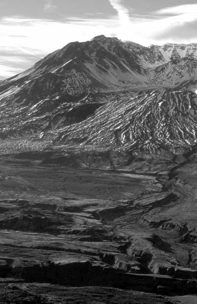
5 Mount St. Helens National Volcanic Monument INTRODUCTION Congress established the 110,000-acre Mount St. Helens National Volcanic Monument in 1982 under Forest Service management to provide opportunities for research, education, and recreation. Mount St. Helens National Volcanic Monument includes an additional 300,000 acres of surrounding National Forest land and is one of three units in the 1.4 million-acre Gifford Pinchot National Forest. This guide includes trails under canopies of old-growth forests and trails built in the heart of the 1980 blast zone. At Mount St. Helens there is something for every explorer from barrier-free interpretive trails to remote backcountry excursions. VOLCANIC HISTORY Mount St. Helens has been an active volcano for thousands of years and continues to be the most active volcano in the Cascade Range. When the mountain showed increased seismic activity in the spring of 1980, scientists flocked to the area, eager to study the awakening volcano. Few could have predicted the effects of the May 18, 1980 eruption. On May 18, 1980, at 8:32 a.m. the unstable north flank of the volcano collapsed, crashing down into the valley below forming the largest landslide in recorded history. This debris avalanche pounded into the Spirit Lake basin and the North Fork Toutle River valley. The landslide exposed explosive gas-rich magma; this released the lateral blast of a hot (680 F) stone-filled wind that traveled up to 700 mph across the surrounding landscape. The blast shattered and flattened 230 square miles of forest. Pyroclastic flows consisting of hot pumice, ash, and gases poured out of the new crater, sterilizing everything in its path. Large mudflows from the melting snow and ice flowed down adjacent river valleys. Having the consistency of wet concrete, these mudflows destroyed bridges, roads, homes, and blocked shipping channels downstream in the Columbia River. Today, Mount St. Helens continues to be closely monitored and studied by scientists with the hope of better understanding and forecasting complex volcanic events around the world. MOUNT ST. HELENS NATIONAL VOLCANIC MONUMENT 1
6 LEAVE NO TRACE OUTDOOR ETHICS These seven easy to follow principles will help you protect Mount St. Helens and enjoy your visit. Plan ahead and prepare: Know the regulations of the area you plan to visit; some areas require permits or fees. Prepare for weather extremes: heat, rain, wind, and snow. Be aware: shelter and shade are scarce in many parts of the Monument. When possible, hike and camp in small groups. Travel and camp on durable surfaces: Stay on trails and established routes. Use designated campsites when available. Avoid fragile riparian areas by staying at least 200 feet from lakes and streams. Do not trench your campsite; instead, establish your camp on well drained soils. Dispose of waste properly: Pack out all trash. Always use toilets where provided. If toilets are not available dig a cat hole at least 6 inches deep, 200 feet from water, and pack out all toilet paper. Leave what you find: Leave rocks, plants, and all natural objects. Do not disturb cultural or historic objects. Minimize campfire impacts: Carry and use a camp stove. Fires are prohibited in many areas. Where fires are allowed, use established fire rings. Keep fires small. Use only sticks from the ground that can be broken by hand. Do not burn trash. Respect wildlife: Observe them from a distance; do not attempt to approach or follow them. Never feed animals. It damages their health and is dangerous. 2 NWIA TRAIL GUIDE
7 Pets are prohibited in many areas. Be considerate of other visitors: Be courteous. Yield to other trail users. Let nature's sounds prevail. Avoid loud voices and noises. SAFETY Be aware that there are certain risks inherent in hiking and backcountry travel. Weather may change quickly and drastically. Trail conditions will change depending on maintenance, season, and weather. Many trails have rough, steep, narrow, or rocky treads. Each trail user is responsible to judge their own experience, ability, and physical condition and select trails which are suitable. To minimize your exposure to risk: Check current weather forecasts and trail conditions prior to your visit. Tell someone where you are going and when you will be back. Do not travel alone. Be physically prepared and adequately equipped for your planned trip. Know your capabilities and limitations. If you feel that you are exceeding your capabilities, be prepared to turn back. Be prepared! Bring the ten essentials: 1 Map and compass 2 Extra food and water 3 Layered clothing and rainwear 4 Flashlight and batteries 5 Matches and fire starter 6 Sunglasses, sunscreen, and hat 7 First aid kit 8 Knife or multi-tool 9 Signal whistle or mirror 10 Emergency shelter THE TEN ESSENTIALS MOUNT ST. HELENS NATIONAL VOLCANIC MONUMENT 3
8 VOLCANIC HAZARDS Mount St. Helens is an active volcano. Travelers should be aware of the potential hazards of hiking on the flanks of the volcano. These hazards are in addition to those normal hazards associated with mountain travel such as changing weather, loose rock, and limited water. Potential volcanic hazards while hiking on or near the flanks of Mount St. Helens may include the following: Mudflows Rock-fall Volcanic ash Rain-caused mudflows, steam bursts, and small ash eruptions may occur in the future without warning. The following are some actions you can take to protect yourself: Minimize time in stream drainages during cloudbursts. Use large rocks for protection from falling debris. Protect your eyes and lungs from ash and debris. Carry sunglasses and use moistened clothing across your nose and mouth to minimize ash exposure. SEASON To assist in planning your trip we have indicated the seasons when, during an average year, we expect the trail to be mostly snow free. MOUNTAIN BIKE INFORMATION - Mountain bikes are becoming increasingly common on many trails. In order to have the safest biking experience with the least impacts to other trail users and resources, please follow these guidelines: Know which trails are open to mountain bikes and ride only on those trails. Yield the right-of-way to other trail users. Slow down and use caution when approaching or overtaking others. Stop, dismount, and move off the trail on the downhill side when encountering horses and other pack animals. Make your presence known when approaching another trail user. Maintain control at all times and approach turns in anticipation of someone around the bend. Stay on designated trails. 4 NWIA TRAIL GUIDE
9 STOCK USER INFORMATION 6 Many trails in the Mount St. Helens National Volcanic Monument are open to horses and other pack animals. It is especially challenging to leave minimal impact to resources when traveling with stock because of the size and weight of the animals, their consumption of vegetation, and their manure, which may contain exotic seeds. By using Tread Lightly concepts, impacts to the backcountry and to other trail users can be minimized: Know which trails are open to stock and ride only on those trails. Travel in small groups in a single file line, staying on the trail. Camp at least 200 feet from lakes and streams. Pack in processed weed-free feed. Do not tie stock to trees. Reduce the duration of your stay to minimize impacts to the site. When breaking camp, be sure to scatter manure. Pack it in, pack it out. Do not burn trash. MOTORIZED INFORMATION 0 Some Forest Service trails are open to motorcycles. Motorized users need to meet the requirements of Washington State Law and Forest Service regulations. State law requires current ORV stickers from the Department of Motor Vehicles. Forest Service regulations require approved spark arrestors. Motorized users must stay on designated trails. Motorcyclists using Forest Service roads must have an operator's license and must wear a helmet. The motorcycle must have the following: a license, headlight, tail light, brake light, left and right side rearview mirror, and a horn. The following are recommendations for motorized trail users on Forest Service trails: Always ride within your ability. Give right-of-way to hikers and stock users. Avoid using trails during the wet season. CLIMBING INFORMATION / Mount St. Helens is a popular climb for both beginning and experienced mountaineers. People climb the volcano year-round. However, late spring through early fall is the most popular time. The climb is MOUNT ST. HELENS NATIONAL VOLCANIC MONUMENT 5
10 not a trail hike; it is a rugged off trail scramble. The climb is suitable for people in good physical condition who are comfortable on steep, irregular terrain. Prior to midsummer, climbers can expect snow. Climbing permits are required year-round above 4800 ft. elevation. From May 15 through October 31 climbing is limited to 100 climbers per day. Permit fees are in effect from April 1 through October 31. Contact Monument Headquarters in Amboy, WA, or visit the web site at: for complete climbing and permit information. MOUNT MARGARET BACKCOUNTRY Hikers may explore trails that lead to the sapphire lakes, pinnacle studded ridges, and flowered mountain slopes of the Mount Margaret Backcountry. Visitors can see the effects of the 1980 eruption of Mount St. Helens in a remote setting. Trails in the Mount Margaret Backcountry have narrow tread, are steep in places, and can climb over 2000 ft. in elevation. Portions of trails are often covered by snow until midsummer. Eight camps can accommodate tent campers at four lakes and four upland sites. Camping permits are required and camping is limited to designated campsites only. Maximum group size for camping is four people. Camping permits can be obtained at Monument Headquarters in Amboy, WA, Cowlitz Valley Ranger Station in Randle, WA, and at Coldwater Ridge Visitor Center. Pets and pack stock are prohibited in the Mount Margaret Backcountry. Fires are not allowed; plan to use a camp stove for cooking. For complete information contact Gifford Pinchot National Forest Headquarters or visit our web site at RESTRICTED AREA Mount St. Helens has restrictions to help protect fragile natural features and processes. The Restricted Area includes the Spirit Lake basin, crater, debris avalanche deposits, and areas around Coldwater Ridge and Johnston Ridge. The following regulations apply: Off trail travel is prohibited. No camping. Pets and bicycles are prohibited. Fires are not allowed. It is unlawful to disturb or remove any natural feature. Access into the crater is strictly prohibited. Violation of these regulations can result in a minimum $100 fine. For more detailed information, contact a Forest Service office or one of the Visitor Centers. 6 NWIA TRAIL GUIDE
11 TRAIL GUIDE SYMBOLS The following symbols are used throughout this guide to indicate which trails are open to which kind of use. w Hikers Permitted on Trail 6 Horses and Other Stock Permitted - Bicycles Permitted on Trail 0 Motorcycles Permitted on Trail Difficulty Symbols The following symbols will be used to designate the degree of difficulty a hiker in average physical condition may encounter on the trail. This difficulty rating is determined by trail condition and route location factors such as steepness of grade, elevation changes, availability of drinking water, obstacles, and harshness of terrain. Snow, ice, rain, and other weather conditions may increase the levels of difficulty. Moderate: Users require limited skill and encounter few challenges. More Difficult: Users require some skill and experience more challenging terrain. Most Difficult: Users require a high degree of skill and experience challenging travel. DISCLAIMER Safety is a major concern for all outdoor activities. Outdoor activities carry some unavoidable risks that everyone needs to understand and respect. The fact that a trail is described in this publication does not mean that it is safe for you. A trail that is safe for an experienced, well-equipped hiker in good physical condition on a warm, dry day may be dangerous for a less experienced or poorly equipped person or on a rainy, foggy, cold, or stormy day. Weather and trail conditions can change, sometimes with little warning. Minimize risks before your hike: Check local weather and trail conditions before you begin Tell someone where you're going and when you will be back Contact the local ranger district office Be alert, prepared, and adequately equipped when in the backcountry Know your own capabilities, experience, and limitations If conditions are dangerous, or if you are not prepared to deal with them safely, choose a different activity The authors and publisher assume no responsibility for the outcome of any activities included in this book. Although we have tried to be accurate, roads, trails, and other conditions cannot be predicted and may have changed since the information was compiled. You are responsible for your own actions. Authors and publisher disclaim liability for any loss or injury arising out of the use of the information in this publication.
12 GIFFORD PINCHOT NATIONAL FOREST Muddy River 504 Johnston Ridge Observatory y 221 Castle Lake Ape Cave 238A A F S. Fork Toutle River 216G Goat Marsh 81 Merrill Lake Spirit Lake 216A B Marble Mtn. 4118' E 216D Goat Mtn. 4965' C LEGEND N Hwy/County Rd. Forest Service Rd Trail District Boundary Monument Boundary Forest Boundary Restricted Area: closed to overnight camping, off-trail travel, pets, campfires, and stock. Crater closed to public entry.

13 Mount St. Helens National Volcanic Monument LOOWIT AREA Mount St. Helens, also known as Loowit or One From Whom Smoke Comes, presents its eruptive history through the many trails in this area. Native Americans of the region considered Mount St. Helens a place where evil spirits reigned. These beliefs came to life as generations witnessed eruptions of Mount St. Helens. Unbeknownst to early settlers pressing into the valleys surrounding the volcano, Mount St. Helens was merely resting and would have profound effects when it awoke in the spring of Hikers on the north side of the volcano can experience the effects of the 1980 eruption and nature s response as plants and animals return and flourish. On the south side of the volcano, hikers can see thousands of years of eruptive history revealed as layer upon layer of mudflows, lava flows, and pyroclastic flows. The Loowit Trail, a 30-mile mountain loop, allows hikers to experience the volcano s story.
14 GIFFORD PINCHOT NATIONAL FOREST LAVA CANYON TRAIL 184 w Barrier-free, interpretive trail Suspension Bridge loop Lower canyon LENGTH: Barrier-free, interpretive trail: 0.4 mile, 0.6 km Suspension Bridge loop: 0.6 mile, 1 km Lower canyon: 1.8 miles, 2.9 km BEST SEASONS: summer, fall LOW ELEVATION: 1600 ft. HIGH: 2800 ft. GAIN: 1200 ft. TRAILHEAD ACCESS: Lava Canyon Trailhead (Forest Road 83) or Smith Creek Trail 225 (Forest Road 8322). DESCRIPTION: There are three sections of the Lava Canyon Trail distinguished by increasing difficulty. The upper trail is barrier-free and paved to a waterfall viewpoint. This portion is the easiest and leads you past a series of interpretive signs, which describe the formation of the canyon. Below the waterfall viewpoint the trail becomes more difficult; it is no longer paved and skirts high cliffs. This segment forms a loop, crossing the canyon on a 125-foot cable suspension bridge. The bridge provides spectacular views of the canyon below but may be unnerving to some hikers. The trail returns on the south side of the canyon, crossing a steel bridge upstream of the waterfalls and rejoins the paved trail. The lower trail is most difficult as it descends steeply into the canyon. If you are uncomfortable with heights, this segment is not for you. Beginning at the suspension bridge, the trail crosses an exposed cliff face followed by a water crossing with a cable grab-line. A 30-foot metal ladder descends a vertical cliff providing access to the canyons deepest recesses and roaring waterfalls. The trail soon intersects Ship Trail 184B which climbs 0.2 mile to a viewpoint atop the Ship, a lava formation that overlooks a long series of waterfalls in the lower canyon. A few tenths of a mile further, the canyon begins to broaden and flatten as it approaches a large alluvial fan spreading into the Smith Creek valley. Here the Lava Canyon Trail ends where it intersects Smith Creek Trail 225. A car shuttle to the lower trailhead permits a one-way downhill hike. 10 NWIA TRAIL GUIDE
15 Mount St. Helens National Volcanic Monument LOOWIT AREA TRAILS Special Conditions: Portions of this trail cross cliffs near high waterfalls and are not suitable for people that are uncomfortable with heights. Several tragic deaths have occurred here when visitors left the trail and fell into swiftly moving water above waterfalls. Parents should keep their children with them at all times and not allow them to wander off the trail. STAY ON THE TRAIL! CINNAMON TRAIL 204 w 6 - LENGTH: 8.2 miles, 13.2 km BEST SEASONS: summer, fall LOW ELEVATION: 2100 ft. HIGH: 3800 ft. GAIN: 1700 ft. TRAILHEAD ACCESS: Kalama Horse Camp (Forest Road 81) or Red Rock Pass Trailhead (Forest Road 81). DESCRIPTION: This trail leaves Kalama Horse Camp and crosses the Kalama River. Climbing through patches of mixed old-growth forest interspersed with timber harvest units, the trail traverses the north flank of Cinnamon Peak. After crossing Forest Road 8122 twice, the trail continues gaining elevation, eventually reaching the ridge top. Views include McBride Lake, Goat Mountain, and Mount St. Helens. The trail eventually descends, joining Toutle Trail 238 just west of Redrock Pass. LOOWIT TRAIL 216 (June Lake Trail 216B to Toutle Trail 238) w - LENGTH: 11.2 miles, 18 km BEST SEASONS: summer, fall LOW ELEVATION: 3400 ft. HIGH: 4800 ft. GAIN: 1400 ft. TRAILHEAD ACCESS: June Lake Trail 216B (Forest Road 83) or Toutle Trail 238 via Sheep Canyon Trailhead (Forest Road 8123). DESCRIPTION: Traveling west from the June Lake Trail 216B junction, the trail passes through an old-growth forest before ascending the first of many rugged lava flows. Wooden posts help mark the path through the rocky terrain. The trail fords Swift Creek, just above 40-foot Chocolate Falls. Continuing across mudflow deposits, the path begins a steep climb through a series of switchbacks. Mount Adams sits on the eastern horizon as you near the junction with Ptarmigan Trail 216A, 3.1 miles from the June Lake Trail. From the junction with the Ptarmigan Trail, a short climb brings you atop the Swift Creek Flow with views of Mount St. Helens, Mount Hood, and Swift MOUNT ST. HELENS NATIONAL VOLCANIC MONUMENT 11
16 Reservoir. Continue 2.5 miles along this scenic and challenging section before arriving at Butte Camp Trail 238A. Here, grass and wildflower meadows offer a good spot for a break. The trail continues northwest, weaving in and out of large, steep canyons and mudflow paths. These canyons have unstable, actively eroding walls. Loose rock often covers the tread making crossings difficult. After 2.8 miles, Sheep Canyon Trail 240 is reached. As you continue north, the trail crosses into the May 18, 1980 blast zone. The trail then descends through groves of silver fir to Toutle Trail 238. A campsite and stream can be found just south of the junction on the Toutle Trail. This is a good choice for overnight camping while hiking around the mountain. Special Conditions: Climbing permit required above 4800 ft. Several steep gully crossings on loose material may be difficult to negotiate. Expect slow travel where the trail crosses rugged lava flows. Check road access information. LOOWIT TRAIL 216 and 216F Toutle Trail 238 north then east to Abraham Trail 216D LOOWIT FALLS TRAIL 216F w LENGTH: 10.2 miles, 16.4 km; Loowit Falls Trail 216F: 0.7 mile, 1.1 km BEST SEASONS: summer, fall LOW ELEVATION (Loowit Trail 216): 3200 ft. HIGH: 4800 ft. GAIN: 1600 ft. LOW ELEVATION (Loowit Trail 216F): 4400 ft. HIGH: 4700 ft. GAIN: 300 ft. TRAILHEAD ACCESS: Toutle Trail 238 via Sheep Canyon Trailhead (Forest Road 8123), Windy Trail 216E or Abraham Trail 216D via Windy Ridge Viewpoint (Forest Road 99). DESCRIPTION: The South Fork Toutle River lies just north of the Loowit and Toutle Trail junction. After fording the river, the trail climbs out of the valley on loose pumice and ash. Castle Ridge Trail 216G is reached in 1.3 miles. The trail swings eastward through the blast zone and across several deep gullies. As you crest Studebaker Ridge, effects of the May 18, 1980 debris avalanche, lateral blast, and pyroclastic flows present themselves in a dramatic panorama. This landscape is now studded with scattered small trees and wildflowers. Herds of elk often migrate through the area. 6.6 miles from South Fork Toutle River, Willow Springs Trail 207A is reached. The Loowit Trail climbs to the junction with Loowit Falls Trail 216F. This short 0.7-mile spur trail takes you to a viewpoint below the falls as it drops from the crater. Continuing eastward, the trail traverses the slope leading to a dependable spring surrounded by fireweed, moss, and willow. You will pass Windy Trail 216E, then begin the climb toward Windy Pass. Ascend steep and narrow switchbacks to Windy Pass, the boundary of the Restricted Area. Descend steep pumice slopes to Abraham Trail 216D, 2 miles from Windy Trail 216E and the end of this segment. 12 NWIA TRAIL GUIDE
17 Special Conditions: Off trail travel is prohibited. No pets or bicycles. Entry into the crater is strictly prohibited. No camping between the South Fork Toutle River and Windy Pass. Limited water. Wooden route marking posts assist you in staying on the trail. Check road access information. LOOWIT TRAIL 216 Abraham Trail 216D to June Lake Trail 216B w - LENGTH: 6.8 miles, 10.9 km BEST SEASONS: summer, fall LOW ELEVATION: 3400 ft. HIGH: 4500 ft. GAIN: 1100 ft. TRAILHEAD ACCESS: Abraham Trail 216D via Windy Ridge Viewpoint (Forest Road 99) or June Lake Trail 216B (Forest Road 83) DESCRIPTION: Beginning at the Abraham Trail, the Loowit Trail crosses the windswept Plains of Abraham for 1.8 miles to the Ape Canyon Trail. Leaving Ape Canyon Trail 234, climb slightly before crossing the Muddy River and Shoestring Creek. The trail in this section is prone to washing out in the spring. You will then descend steadily along the flank of the volcano encountering views of the Muddy River and Mount Hood. The trail climbs onto a series of old lava flows with unstable footing. Wooden route marking posts help guide you through the lava flow. This section of the trail ends with a descent into an old-growth forest, meandering along an abrupt timber edge before arriving at June Lake Trail 216B. Special Conditions: Climbing permit required above 4800 ft. Several steep and loose gully crossings. PTARMIGAN TRAIL 216A w - LENGTH: 2.1 miles, 3.4 km BEST SEASONS: summer, fall LOW ELEVATION: 3700 ft. HIGH: 4700 ft. GAIN: 1000 ft. TRAILHEAD ACCESS: Climbers Bivouac (Forest Road ) or Loowit Trail 216 DESCRIPTION: This trail climbs steadily, passing through forest and small meadows. Views of Mount Adams, Mount Hood, and Yale Reservoir present themselves along the southern horizon. The junction with Loowit Trail 216 is reached in 2 miles. A composting toilet is located on a short, marked side trail, just beyond the junction. A basin below Monitor Ridge marks the end of the Ptarmigan Trail and a good lunch spot with views to the south. Beyond this point is the Monitor Ridge Climbing route, which requires a climbing permit. Special Conditions: Climbing permit required above 4800 ft. No water available. MOUNT ST. HELENS NATIONAL VOLCANIC MONUMENT 13
18 JUNE LAKE TRAIL 216B w - LENGTH: 1.6 miles, 2.6 km BEST SEASONS: summer, fall LOW ELEVATION: 2700 ft. HIGH: 3400 ft. GAIN: 700 ft. TRAILHEAD ACCESS: June Lake Trailhead (Forest Road 83) or Loowit Trail 216. DESCRIPTION: June Lake was formed by a 2,000-year-old lava flow blocking a tributary of Swift Creek. The lake is nestled along the base of a basalt cliff over which a waterfall pours, replenishing the lake s cold, clear water. This trail is a good choice for families and beginning hikers. Start by gently climbing through a young forest, following the rushing sounds of a tributary of Swift Creek that flows from June Lake. The lake is soon reached providing a great place to picnic. Continuing, the trail climbs steeply for 0.25 mile to its junction with Loowit Trail 216. June Lake Trail 216B is the shortest access to Loowit Trail 216. Special Conditions: Practice Leave No Trace principles. Pack out all litter. No camping within 200 feet of the lakeshore. PINE CREEK TRAIL 216C w LENGTH: 0.4 mile, 0.6 km BEST SEASONS: summer, fall LOW ELEVATION: 2900 ft. HIGH: 3100 ft. GAIN: 200 ft. TRAILHEAD ACCESS: Forest Road 83. DESCRIPTION: Pine Creek Trail 216C provides access to the primitive Pine Creek Shelter. This cedar shake covered shelter was built in 1921 and restored in The trail passes the shelter eventually ending at the edge of The Lahar, a 1980 mudflow. Special Conditions: Practice Leave No Trace principles. Pack out litter. WINDY TRAIL 216E w LENGTH: 1 mile, 1.6 km BEST SEASONS: summer, fall LOW ELEVATION: 4100 ft. HIGH: 4300 ft. GAIN: 200 ft. TRAILHEAD ACCESS: Truman Trail 207 (Forest Road 99) or Loowit Trail 216. DESCRIPTION: The Windy Trail provides a connection from Truman Trail 207 to Loowit Trail 216. It is the most direct access for hikers from Windy Ridge Viewpoint on Forest Road 99 to the Loowit Trail and Loowit Falls Viewpoint Trail 216F. The Windy Trail passes the location of the Timberline Campground and Viewpoint that were destroyed in the 1980 eruption. If you look closely you can still see traces of asphalt from the road and parking lot. Special Conditions: No off trail travel. No pets, stock, or bicycles. Day-use only. 14 NWIA TRAIL GUIDE
19 CASTLE LAKE TRAIL 221 and CASTLE RIDGE TRAIL 216G w LENGTH: Castle Lake Trail 3.9 miles, 6.3 km; Castle Ridge Trail: 2 miles, 3.2 km BEST SEASONS: summer, fall LOW ELEVATION: Castle Lake Trail 221: 2500 ft. HIGH: 4300 ft. GAIN: 1800 ft. LOW ELEVATION: Castle Ridge Trail 216G: 4000 ft. HIGH: 4300 ft. GAIN: 200 ft. TRAILHEAD ACCESS: Loowit Trail 216 via Sheep Canyon Trailhead (Forest Road 8123) or Weyerhauser Road DESCRIPTION: The Castle Ridge Trail 216G creates a connection between Loowit Trail 216 and Weyerhauser Road This ridge top hike offers views of the blast area, Mount St. Helens, the South Fork Toutle River, and Castle Lake. A trip down the minimally maintained Castle Lake Trail 221 brings you through the effects of the 1980 eruption to the shore of Castle Lake. The lake was created when the debris avalanche dammed South Fork Castle Creek. Passing through boggy areas and paralleling Castle Creek, the trail circles around the ridge separating Castle Creek and Castle Lake. Wildlife, including elk and waterfowl, can often be seen. Special Conditions: Off trail travel prohibited. No fires allowed. Camping allowed only at Castle Lake. Practice Leave No Trace principles. Check road access information. TRAIL OF TWO FORESTS 233 w LENGTH: 0.3 mile BEST SEASONS: year-round LOW ELEVATION: 1860 ft. HIGH: 1885 ft. GAIN: 25 ft. TRAILHEAD ACCESS: Trail of Two Forests Trailhead (Forest Road 8303). DESCRIPTION: Interpretive signs guide you through this lava flow from Mount St. Helens that engulfed and consumed a forest 1,900 years ago. The boardwalk loop trail takes you to many examples of tree casts formed as lava flowed around trees and cooled, leaving impressions of the forest. If you bring a flashlight, you can enter the log crawl, a horizontal log cast tunnel over 60 feet long. Picnic tables provide a great place to eat lunch. Special Conditions: To protect fragile geologic features and plant life, please stay on the boardwalk. MOUNT ST. HELENS NATIONAL VOLCANIC MONUMENT 15
20 APE CANYON TRAIL 234 w - LENGTH: 5.5 miles, 8.9 km BEST SEASONS: summer, fall LOW ELEVATION: 2900 ft. HIGH: 4200 ft. GAIN: 1300 ft. TRAILHEAD ACCESS: Ape Canyon Trailhead (Forest Road 83) or Loowit Trail 216 DESCRIPTION: Beginning next to the mudflow that traveled down the Muddy River drainage, the trail climbs steadily through a plantation of young trees before entering groves of giant Douglas fir, silver and noble fir. The trail then emerges on an open ridge top with views east into Ape Canyon and, in the distance, Mount Adams. Wildflowers, when in bloom, paint these meadows in vibrant colors. Continuing along the ridge, the trail passes through patches of 1980 standing dead forest before emerging at the top of Ape Canyon, where it terminates at the junction with Loowit Trail 216. BLUE HORSE TRAIL 237 w 6 - LENGTH: 5.5 miles, 8.9 km BEST SEASONS: spring, summer, fall LOW ELEVATION: 2600 ft. HIGH: 4000 ft. GAIN: 1400 ft. TRAILHEAD ACCESS: Toutle Trail 238 (Forest Road 81). DESCRIPTION: The trail leaves Toutle Trail 238 at Forest Road It crosses Forest Road 81 before climbing gently through a lodgepole pine forest and crosses Toutle Trail 238 again in 2.8 miles. The trail continues to climb and then crosses an intermittently active mudflow. It then follows the west side of the mudflow before turning west through a noble fir forest to where the trail ends at Toutle Trail 238, 0.7 mile south of Sheep Canyon Trail 240. To extend your ride or hike, travel south on Toutle Trail 238, 7.9 miles back to your starting point. Special Conditions: The upper end of this trail has been buried several times by small mudflows since TOUTLE TRAIL 238 w 6 - LENGTH: 13.6 miles, 21.9 km BEST SEASONS: spring, summer, fall LOW ELEVATION: 2100 ft. HIGH: 4000 ft. GAIN: 1900 ft. TRAILHEAD ACCESS: Kalama Horse Camp (Forest Road 81), Red Rock Pass Trailhead (Forest Road 81), Blue Lake Trailhead (Forest Road 8123), or Sheep Canyon Trail 240 (Forest Road 8123). DESCRIPTION: The trail starts at Kalama Horse Camp and follows the springfed Kalama River. Passing through moss-carpeted lava flows and a mixed conifer forest, the trail junctions with Blue Lake Horse Trail 237, 3.7 miles from 16 NWIA TRAIL GUIDE
21 the horse camp. Reaching McBride Lake, the trail climbs above the lake with views of Mount St. Helens. Forest Road 81 is crossed at Red Rock Pass, 5.7 miles from Kalama Horse Camp. Leaving Red Rock Pass, the trail crosses a 1,900-year-old lava flow before entering a lodgepole pine forest. Butte Camp Trail 238A splits to the north as the Toutle Trail travels west, reaching the Blue Lake Trailhead, 3.2 miles from Red Rock Pass. Blue Lake is passed as the trail enters an old-growth forest. The trail climbs northward to Huckleberry Saddle and the junction with Blue Lake Horse Trail 237. The trail continues northward, to its intersection with Sheep Canyon 240. Horses are not allowed beyond here but may exit to the end of road 8123 at the Sheep Canyon Trailhead. The Toutle Trail continues 1.6 miles before terminating near the South Fork Toutle River at Loowit Trail 216. Special Conditions: Horses are prohibited on the Toutle Trail 238 north of the Sheep Canyon Trail 240 intersection, on Sheep Canyon Trail 240 east of Toutle Trail 238, and on Butte Camp Trail 238A. Check road access information. BUTTE CAMP TRAIL 238A w - LENGTH: 2.7 miles, 4.3 km BEST SEASONS: summer, fall LOW ELEVATION: 3500 ft. HIGH: 4800 ft. GAIN: 1300 ft. TRAILHEAD ACCESS: Toutle Trail 238 via Red Rock Pass (Forest Road 81) or Loowit Trail 216. DESCRIPTION: The trail branches from Toutle Trail 238, 1.3 miles from Red Rock Pass. Begin by crossing a 1,900-year-old lava flow that is covered with delicious huckleberries when in season. The trail climbs gradually to Lower Butte Camp, an inviting meadow with water and wildflowers which offers good camping. It then climbs in a series of switchbacks to Upper Butte Camp. An open hillside in this segment provides vistas to the south and east. Upper Butte Camp is not really a camp but a sensitive research area. Continue upslope to the junction with Loowit Trail 216 where Mount St. Helens awaits. Special Conditions: Climbing permit required above 4800 ft. APE CAVE TRAIL 239 Lower cave: Upper cave: Ape Cave Trail: w LENGTH: Lower Ape Cave: 0.8 mile, 1.3 km; Upper Ape Cave: 1.5 miles, 2.4 km; Ape Cave Trail: 1.3 miles, 2.1 km BEST SEASONS: all LOW ELEVATION: 1800 ft. HIGH: 2500 ft. GAIN: 700 ft. TRAILHEAD ACCESS: Apes' Headquarters (Forest Road 8303). To protect big game habitat, Forest Road 8303 is closed to motorized use during the winter months. Plan to park at the Trail of Two Forests Trailhead and hike or snowshoe the 1 mile to the cave in winter. MOUNT ST. HELENS NATIONAL VOLCANIC MONUMENT 17
22 DESCRIPTION: Formed 1,900 years ago and first explored in the early 1950s by a local scout troop, the cave was initially the longest known lava tube in the continental United States. Ape Cave was named by the scout troop in honor of their sponsor, the St. Helens Apes. Today the cave is a popular visitor attraction, with many thousands of visitors annually. Apes' Headquarters, a Forest Service building near the entrance, provides lantern rentals and guided walks during the summer. The lower cave is the more popular route with its fairly level, mudflow-covered floor. Highlights include railroad tracks and the "meatball." Allow at least an hour to complete the 1.6-mile round trip. The upper cave travels over large rock piles and requires scaling of an 8-foot lava fall. Two-thirds of the way up you will pass beneath The Skylight, an opening to the surface. Do not try to climb out; this is NOT an exit. The upper entrance is only 0.25 mile ahead. Allow 2.5 hours for travel through the upper cave to Ape Cave Trail 239. The above ground Ape Cave Trail 239 provides an easy return route to the main entrance and Apes Headquarters. Special Conditions: Bring at least two sources of light per person, sturdy shoes, and warm clothing. Temperatures remain 42 F/5.6 C year-round. Cave environments are fragile. Pets, smoking, fireworks, and food are prohibited in the cave. SHEEP CANYON TRAIL 240 w 6 - LENGTH: 2.5 miles, 4 km BEST SEASONS: summer, fall LOW ELEVATION: 3400 ft. HIGH: 4600 ft. GAIN: 1200 ft. TRAILHEAD ACCESS: Sheep Canyon Trailhead (Forest Road 8123) or Loowit Trail 216. DESCRIPTION: This trail offers an excellent loop opportunity through a continually changing volcanic landscape. From the Sheep Canyon Trailhead the trail gently ascends into an old-growth forest. The trail then follows the canyon edge of Sheep Creek where a 75-foot ribbon of water streaming down a solid rock cliff can be seen. Sheep Creek was scoured to bedrock by an abrasive mudflow in 1980 that banked from side to side as it roared down the valley. The trail merges with Toutle Trail 238 for several hundred feet before branching eastward and crossing a small side stream on a bridge. Continuing, the trail passes through forest and over old lava flows before ending at the junction with Loowit Trail 216. To extend your walk, travel north then west on Loowit Trail 216 to the South Fork Toutle River and junction with Toutle Trail 238. Take the Toutle Trail south to the Sheep Canyon Trail and back to your starting point. This loop is 7.1 miles long. Special Conditions: Horses are prohibited east of the junction with Toutle Trail 238. Check road access information. 18 NWIA TRAIL GUIDE
23 FOSSIL TRAIL 242 w 6 - LENGTH: 7 miles, 11.3 km BEST SEASONS: summer, fall LOW ELEVATION: 2100 ft. HIGH: 3500 ft. GAIN: 1400 ft. TRAILHEAD ACCESS: Kalama Horse Camp (Forest Road 81) or Forest Road DESCRIPTION: This trail, completed in 2003, starts in the Kalama Horse Camp before swinging northward and crossing Forest Road 81. After climbing steadily along an old roadbed, the trail enters a magnificent stand of oldgrowth. The trail passes through a 0.25-mile stretch of young trees before reentering the older forest. Traversing the western face of Goat Mountain, you enter an ancient stand of old-growth noble fir, ending at a saddle on the north shoulder of the peak. The trail drops downslope and connects with an abandoned road leading to Forest Road 8123, 1 mile west of the Blue Lake Trailhead. MOUNT ST. HELENS NATIONAL VOLCANIC MONUMENT 19
24 GIFFORD PINCHOT NATIONAL FOREST Muddy River Coldwater Lake Coldwater Ridge VC 504 y 230A y Johnston Ridge Observatory Castle Lake E Spirit Lake D H N 216G LEGEND 8123 Hwy/County Rd. Forest Service Rd Trail District Boundary Monument Boundary Forest Boundary Restricted Area: closed to overnight camping, off-trail travel, pets, campfires, and stock. Crater closed to public entry. 207A 211C

25 Mount St. Helens National Volcanic Monument BLAST ZONE The north side of Mount St. Helens contains many opportunities for the hiker who wants to experience the effects of the May 18, 1980 eruption. What was once a lush forest on the northern flank of the volcano became a barren plain. Further north, the Mount Margaret Backcountry became a tangle of blown down trees. The volcano s environment continues to evolve as plants and animals recolonize these slopes. This return of life offers an unparalleled opportunity to observe the changing landscape year by year. The Spirit Lake basin continues to hold memories of the place once popular for crystal clear water and lakeshore camping. A Forest Service guard station, campgrounds, and lodges served tourists as they journeyed to Spirit Lake each summer to recreate. The May 18, 1980 eruption ever changed this once crowded vacation spot. With the opportunity to visit this recovering landscape comes the responsibility to help conserve it. A Restricted Area exists to protect portions of this fragile landscape while it recovers and allows scientists to study this living laboratory. The Restricted Area includes the entire Spirit Lake basin, the crater, the debris avalanche deposits, and the areas around Coldwater Ridge and Johnston Ridge.
26 GIFFORD PINCHOT NATIONAL FOREST BOUNDARY TRAIL 1 Hummocks Trail 229 to Johnston Ridge Observatory w LENGTH: 4.6 miles, 7.4 km BEST SEASONS: summer, fall LOW ELEVATION: 2500 ft. HIGH: 4200 ft. GAIN: 1700 ft. TRAILHEAD ACCESS: Hummocks Trail 229 via Hummocks Trailhead or Johnston Ridge Observatory. Both access points reached via State Route 504. DESCRIPTION: The Boundary Trail starts at its intersection with the Hummocks Trail 229, 0.5 mile east of the Hummocks Trailhead. Elk can often be seen around the junction, grazing in the grassy meadows. The trail crosses debris avalanche deposits before beginning the steep and steady climb of Johnston Ridge. Switchbacks cross patches of blast shattered stumps and blown down trees. After the initial 1200-foot elevation gain, the trail traverses Johnston Ridge, offering views of the debris-filled North Fork Toutle River valley and Mount St. Helens. The trail then passes Loowit Viewpoint, climbs 200 feet in 0.8 mile, and brings you to Johnston Ridge Observatory, 4.6 miles from the junction with Hummocks Trail 229. Special Conditions: Off trail travel prohibited. No pets, stock, or bicycles. Day-use only. BOUNDARY TRAIL 1 Johnston Ridge Observatory to Coldwater Trail 230 and HARRY S RIDGE TRAIL 1E w Harry's Ridge Trail: LENGTH: 4.8 miles, 7.7 km; Harry's Ridge Trail: 0.8 mile, 1.3 km BEST SEASONS: summer, fall LOW ELEVATION: 4000 ft. HIGH: 5000 ft. GAIN: 1000 ft. TRAILHEAD ACCESS: Johnston Ridge Observatory (State Route 504). DESCRIPTION: To access the trail from Johnston Ridge Observatory, either hike the Eruption Trail 201 or use the trailhead at the east end of the parking lot. A message board and interpretive sign are reached 0.8 mile from Johnston Ridge Observatory. From here you continue east along Johnston Ridge to Devil's Elbow. At this point the trail crosses a steep exposed slope that drops precipitously to the valley below. For many, this traverse marks the end of their eastward travel as the exposure exceeds their comfort level. The trail gradually descends to the junction with Truman Trail 207, 2.5 miles 22 NWIA TRAIL GUIDE
27 Mount St. Helens National Volcanic Monument BLAST ZONE TRAILS from Johnston Ridge Observatory. As the trail continues, it climbs north across landslide deposits at The Spillover. Here, on May 18, 1980, the debris avalanche surged over the ridge and spilled into South Coldwater Creek valley. Wooden posts mark the trail and help guide you over The Spillover. The trail ascends a long, gentle grade before intersecting with Harry's Ridge Trail 1E. This spur of 0.8 mile provides outstanding views of Spirit Lake and Mount St. Helens. Continuing north, the Boundary Trail climbs a series of switchbacks before gaining the ridgeline above St. Helens Lake. Traversing, you pass several rock pinnacles and through a natural rock arch before arriving at the junction with Coldwater Trail 230, 4.8 miles east of Johnston Ridge Observatory. Special Conditions: Off trail travel prohibited. No pets, stock, or bicycles. Day use only. BOUNDARY TRAIL 1 Norway Pass Trailhead to Coldwater Trail 230 and COLDWATER PEAK TRAIL 1G w - LENGTH: 9.3 miles, 15 km; Coldwater Peak Trail: 0.7 mile, 1.1 km BEST SEASONS: summer, fall LOW ELEVATION (Boundary Trail 1): 3800 ft. HIGH: 5800 ft. GAIN: 2000 ft. LOW ELEVATION (Boundary Trail 1G): 5000 ft. HIGH: 5727 ft. GAIN: 727 ft. TRAILHEAD ACCESS: Johnston Ridge Observatory (State Route 504) or Norway Pass Trailhead (Forest Road 26). DESCRIPTION: This trail segment begins at Norway Pass Trailhead on Forest Road 26. A well with hand pump at the trailhead provides water for last minute fill-ups. The trail begins with a 1.2-mile ascent to Independence Ridge Trail 227A. Climbing another 1 mile, Norway Pass is reached providing a great place for photos of Mount St. Helens across Spirit Lake. At this point the trail intersects with Independence Pass Trail 227 which turns south. Continuing north, the Boundary Trail climbs for 0.9 mile until it reaches Lakes Trail 211. From this junction the trail heads west, traversing flower-laden slopes, passing Bear Camp, and reaching Whittier Ridge Trail 214 after 1.8 miles. A short ascent brings you to Mount Margaret at 5858 ft., the highest point on the ridge. The trail again descends in a series of switchbacks until it reaches Margaret Camp. The path then winds around a ridge before arriving at Dome Camp. Water can be found in small springs on the north side of the ridge near each camp. MOUNT ST. HELENS NATIONAL VOLCANIC MONUMENT 23
28 Continuing south and west, the trail skirts below the imposing bulk of a rock pinnacle called The Dome. The trail then descends steadily through wildflowers to a saddle with a small but dependable spring just north of Coldwater Peak. Coldwater Peak Trail 1G is reached 4 miles from Whittier Ridge Trail 214. This side trail takes you to the top of Coldwater Peak where a fire lookout once stood but is now the home of radio relay transmitters and volcano monitoring equipment. Outstanding views abound including neighboring volcanoes, Spirit Lake, and St. Helens Lake. Traveling south from the junction with Coldwater Peak Trail 1G, the Boundary Trail traverses slopes dotted with small noble firs and wildflowers, reaching Coldwater Trail 230 in 0.5 mile. Special Conditions: Off trail travel south of Boundary Trail 1 is prohibited, including St. Helens Lake. No pets or stock. Bicycles prohibited west of Coldwater Trail 230. Camping allowed in the Mount Margaret Backcountry by permit only. BOUNDARY TRAIL 1 Norway Pass Trailhead to Bear Meadow w - LENGTH: 5.6 miles, 9 km BEST SEASONS: summer, fall LOW ELEVATION: 3800 ft. HIGH: 4500 ft. GAIN: 700 ft. TRAILHEAD ACCESS: Norway Pass Trailhead (Forest Road 26) or Bear Meadow Viewpoint (Forest Road 99). DESCRIPTION: Starting at the Norway Pass Trailhead, the Boundary Trail crosses Forest Road 26. East of the road, the trail climbs to a saddle north of Bismarck Mountain. The trail passes through remnant standing dead forest for the next 2.5 miles. These trees, killed by the 1980 lateral blast, are now rotting and falling to the ground, creating a thick organic bed to nourish new vegetation. 1.5 miles from the trailhead is the junction with Ghost Lake Trail 1H. A short side trip of 0.4 mile leads to the lakeshore. Throughout this area you will see young conifers that survived the searing blast because they were safely buried under snow. Following the spring snowmelt in 1980, these trees emerged from the ash and are the beginning of a new forest. The Boundary Trail then gradually climbs a series of switchbacks to the edge of the green timber. The Strawberry Mountain Trail 220 junction is reached about 0.5 mile inside the forest timber. The trail then descends to Forest Road 99 at Bear Meadow, 5 miles from Norway Pass Trailhead. Special Conditions: Expect to find down trees across the trail in this segment. The standing dead forest is gradually decomposing and falling to the ground. 24 NWIA TRAIL GUIDE
29 ERUPTION TRAIL 201 w LENGTH: 0.5 mile, 0.8 km BEST SEASONS: spring, summer, fall LOW ELEVATION: 4200 ft. HIGH: 4300 ft. GAIN: 100 ft. TRAILHEAD ACCESS: Johnston Ridge Observatory (State Route 504). DESCRIPTION: This popular, barrier-free interpretive trail starts at the Johnston Ridge Observatory observation deck. Ascend by way of paved switchbacks to the top of a ridge. Interpretive signs record the May 18, 1980 eruption and volcanic history of the area. Enjoy impressive views of Mount St. Helens, the blast zone, Mount Adams, and the Mount Margaret Backcountry. The trail continues eastward then descends to the junction with Boundary Trail 1. By staying on the paved path you will return to the main parking lot. Special Conditions: Off trail travel prohibited. No pets or bicycles. TRUMAN TRAIL 207 and WILLOW SPRINGS TRAIL 207A w - LENGTH: Truman Trail 207: 5.7 miles, 9.2 km Willow Springs Trail: 0.8 mile, 1.3 km BEST SEASONS: summer, fall LOW ELEVATION: 3600 ft. HIGH: 4200 ft. GAIN: 600 ft. TRAILHEAD ACCESS: Windy Ridge Viewpoint (Forest Road 99) or Boundary Trail 1 via Johnston Ridge Observatory (State Route 504). DESCRIPTION: Truman Trail 207 immerses you in the area devastated by the 1980 eruption. Looking north, you see log-filled Spirit Lake topped by Mount Margaret. To the south you look upward at Mount St. Helens crater and lava dome. The Truman Trail begins by following a road built by the U.S. Army Corps of Engineers to access the Spirit Lake pumping station. Shortly after the 1980 eruption the water level in Spirit Lake rose alarmingly, threatening to overtop the debris dam and to send a deluge down the Toutle Valley. To help alleviate this danger, barge-mounted pumps were installed to remove water from the lake. Pumping continued until a 1.7-mile long tunnel could be completed, allowing Spirit Lake to drain into South Coldwater Creek. Flanked by ever-growing patches of lupine, Indian paintbrush, and other wildflowers, the trail crosses several streams that originate in the crater. Wooden marking posts aid you in staying on trail as you travel across the pumice plain and climb the debris avalanche to the junction with Boundary Trail 1. To extend your walk take Willow Springs Trail 207A from the junction with Truman Trail 207. This 0.8-mile trail provides a link to Loowit Trail 216 and offers other loop opportunities. Special Conditions: Off trail travel prohibited. No pets or stock. Day-use only. Bicycles are prohibited west of the junction with Abraham Trail 216D. MOUNT ST. HELENS NATIONAL VOLCANIC MONUMENT 25
30 META LAKE TRAIL 210 w LENGTH: 0.3 mile, 0.5 km BEST SEASONS: summer, fall LOW ELEVATION: 3620 ft. HIGH: 3640 ft. GAIN: 20 ft. TRAILHEAD ACCESS: Meta Lake Trailhead (Forest Road 99). DESCRIPTION: Walk a paved interpretive trail and discover how life survived in the blast zone. The forest you see today survived the 1980 eruption, buried under a blanket of snow. During July you may see swarms of squirming tadpoles along the lakeshore on their journey to adulthood. Special Conditions: To protect fragile lakeshore habitat, please stay on the trail and lakeshore-viewing platform. LAKES TRAIL 211 (Coldwater Lake Boat Launch to Coldwater Trail 230) and ELK BENCH TRAIL 211D w LENGTH: 4.5 miles, 7.2 km; Elk Bench Trail: 0.8 mile, 1.3 km BEST SEASONS: spring, summer, fall LOW ELEVATION: (Lakes Trail 211): 2500 ft. HIGH: 2700 ft. GAIN: 200 ft. LOW ELEVATION: (Lakes Trail 211D): 2500 ft. HIGH: 3200 ft. GAIN: 700 ft. TRAILHEAD ACCESS: Coldwater Lake Boat Launch or Coldwater Trail 230 via South Coldwater Trail 230A. Both access points reached via State Route 504. DESCRIPTION: The Lakes Trail begins at Coldwater Lake Boat Launch and follows the northwest shore. 1 mile from the trailhead is the intersection with Elk Bench Trail 211D. The Elk Bench Trail climbs 700 ft. in 0.8 mile to Coldwater Ridge Visitor Center. Lakes Trail 211 continues along the lakeshore, passing through blown down trees, wildflowers, and alder thickets. Deer, elk, and coyotes often use the trail, traveling between feeding grounds. Minnie Peak and its impressive rocky summit frame the valley to the north. The head of Coldwater Lake is reached after 4 miles, providing a good turn around or picnic spot. The junction with Coldwater Trail 230 is 0.5 mile from the head of Coldwater Lake. Special Conditions: Off trail travel prohibited. No pets, stock, or bicycles. Day-use only. LAKES TRAIL 211 Coldwater Trail 230 to Boundary Trail 1 w LENGTH: 9 miles, 14.5 km BEST SEASONS: summer, fall LOW ELEVATION: 2700 ft. HIGH: 5200 ft. GAIN: 2500 ft. TRAILHEAD ACCESS: Coldwater Lake Boat Launch (State Route 504), Coldwater Trail 230 via South Coldwater Trailhead (State Route 504), or Boundary Trail 1 via Norway Pass Trailhead (Forest Road 26). 26 NWIA TRAIL GUIDE
31 DESCRIPTION: Continuing northeast from the junction with Coldwater Trail 230, Lakes Trail 211 climbs beneath cliffs above Coldwater Creek. Views of the imposing Whittier Ridge and unnamed rocky peaks in the Mount Margaret Backcountry begin to unfold. This glacial valley with its typical U shape and glacial striations on rock ledges are visible from the trail as it climbs steadily for 3.3 miles to Snow Lake and Snow Camp. The trail resumes climbing through the standing dead forest, providing a bird s eye view of Snow Lake. You pass the junction with Whittier Ridge Trail 214 at Pleasant Pass. Leaving the pass, you traverse high above Shovel Lake. Shovel Lake Trail 211C descends steeply for 0.5 mile to the quiet shoreline. The Lakes Trail continues along the ridge separating Shovel Lake from the Green River valley. The trail then descends as it crosses the outlet of Shovel Lake that feeds into Panhandle Lake. A short climb over a rocky point along the shore of Panhandle Lake brings you to the short spur trail down to Panhandle Camp. From Panhandle Lake the trail climbs over a low pass before dropping down to Obscurity Lake and Camp, passing a small cascading waterfall along the way. The trail then begins a traverse heading south toward Grizzly Lake. After crossing the outlet to Grizzly Lake, the trail climbs a steep north slope often covered in ripe huckleberries during August and September. The trail crests Bear Pass with inspiring views of the surrounding volcanoes and Spirit Lake. A short distance downhill is the junction with Boundary Trail 1, 3.1 miles from Norway Pass Trailhead. Special Conditions: No pets, stock, or bicycles. Camping by permit only. Fires are prohibited. Please refer to Mount Margaret Backcountry regulations. WHITTIER RIDGE TRAIL 214 w LENGTH: 2.1 miles, 3.4 km BEST SEASONS: summer, fall LOW ELEVATION: 5200 ft. HIGH: 5883 ft. GAIN: 683 ft. TRAILHEAD ACCESS: Boundary Trail 1 via Norway Pass Trailhead (Forest Road 26) or Lakes Trail 211 (State Route 504). DESCRIPTION: Whittier Ridge provides one of the most challenging hikes in the Mount Margaret Backcountry. Following the jagged pinnacle studded ridge you will have unparalleled views into the Coldwater valley drainage and several alpine lakes. The trail begins at the junction with Boundary Trail 1, traversing subalpine slopes to gain Whittier Ridge proper. Continuing, the trail becomes narrower, following close to the ridge top. To cross sheer cliffs, the trail was blasted out of solid rock. At 0.75 mile, the summit of Mount Whittier is reached at 5883 ft. elevation. Over the horizon to the north is Mount Rainier, to the east lies Mount Adams, and to the south, Mount Margaret and the crater of Mount St. Helens. The trail proceeds along the ridge before dropping to the junction with Lakes Trail 211 at Pleasant Pass. Special Conditions: This trail is suitable for experienced hikers comfortable scrambling in steep mountainous terrain. MOUNT ST. HELENS NATIONAL VOLCANIC MONUMENT 27
32 ABRAHAM TRAIL 216D w - LENGTH: 2 miles, 3.2 km BEST SEASONS: summer, fall LOW ELEVATION: 4200 ft. HIGH: 4500 ft. GAIN: 300 ft. TRAILHEAD ACCESS: Truman Trail 207 via Windy Ridge Viewpoint (Forest Road 99) or Loowit Trail 216 (via Ape Canyon 234 and Forest Road 83). DESCRIPTION: The Abraham Trail creates a connector between the Loowit Trail and the Truman Trail. The trail is named for the barren Plains of Abraham covered by pyroclastic surges on May 18, Begin by leaving Truman Trail 207 and climb a ridgeline. Sand ladders aid in your ascent over hillsides covered by loose pumice. The terrain opens as you enter the Plains of Abraham with views of Mount Rainier to the north and Mount Adams to the east. HARMONY TRAIL 224 w LENGTH: 1 mile, 1.6 km BEST SEASONS: summer, fall LOW ELEVATION: 3400 ft. HIGH: 4100 ft. GAIN: 700 ft. TRAILHEAD ACCESS: Harmony Viewpoint (Forest Road 99). DESCRIPTION: Harmony Trail 224 is the only access to Spirit Lake. Now underwater is the former location of the rustic Harmony Falls Lodge and Harmony Falls. Today you will find a changed shoreline, altered by the effects of the 1980 debris avalanche and lateral blast. When the debris avalanche slammed into the lake, a tidal wave surged 800 feet up the opposite shore. As the wave crashed back down it swept the already blown down trees into the lake. The resulting log mat drifts with the wind on the lake surface. The debris avalanche created a dam at the lake outlet ultimately raising the water level. The level of Spirit Lake is now controlled by the 1.7-mile man-made tunnel that drains into South Coldwater Creek. Special Conditions: Off trail travel prohibited. No pets, stock, or bicycles. Day-use only. No fishing or swimming is allowed at Spirit Lake. SMITH CREEK TRAIL 225 w - LENGTH: 10.2 miles, 16.4 km BEST SEASONS: summer, fall LOW ELEVATION: 1600 ft. HIGH: 4400 ft. GAIN: 2800 ft. TRAILHEAD ACCESS: Forest Road 99 or Forest Road DESCRIPTION: The Smith Creek Trail offers a chance to observe the immense impact of the 1980 eruption. The trail quickly drops from Forest Road 99 into the Smith Creek valley. Two waterfalls are located near the foot of the steepdescent. Following the valley bottom, the trail crosses Ape Canyon Creek and 28 NWIA TRAIL GUIDE
33 then Muddy River. Here the trail intersects Lava Canyon Trail 184. Continue downstream for 1 mile to the Lower Smith Creek Trailhead and Forest Road Special Conditions: Loose pumice surface, especially at the northern end of the trail. INDEPENDENCE PASS TRAIL 227 and INDEPENDENCE RIDGE TRAIL 227A w LENGTH: 3.4 miles, 5.5 km; Independence Ridge Trail: 1.3 miles, 2.1 km BEST SEASONS: summer, fall LOW ELEVATION (Trail 227): 4040 ft. HIGH: 4680 ft. GAIN: 640 ft. LOW ELEVATION (Trail 227A): 4500 ft. HIGH: 4700 ft. GAIN: 200 ft. TRAILHEAD ACCESS: Independence Pass Trailhead (Forest Road 99) or Boundary Trail 1 via Norway Pass Trailhead (Forest Road 26). DESCRIPTION: The trail climbs for 0.25 mile to Independence Pass offering excellent views of Spirit Lake, Mount St. Helens, the crater, and lava dome. The trail continues north, contouring steep pumice slopes providing a bird s eye view of Spirit Lake. 1 mile from the trailhead is the junction with Independence Ridge Trail 227A. Then the Independence Pass Trail loops around the western flank of Independence Ridge. A spectacular viewpoint is reached in 1.5 miles. Beyond this viewpoint the trail narrows, passing towering rock pinnacles uncloaked by the lateral blast. The trail ends at its junction with Boundary Trail 1 at Norway Pass, 3.5 miles from the trailhead. To extend your walk, hike the Independence loop. From Norway Pass, travel east on Boundary Trail 1 for 1.3 miles to the junction with Independence Ridge Trail 227A. Continue south on the Independence Ridge Trail, gaining the southeast shoulder of the ridge. In 1.3 miles you will reach the junction with the Independence Pass Trail 227. The round trip is 7 miles from Independence Pass Trailhead. Special Conditions: Off trail travel prohibited west of Independence Pass Trail 227. No pets, stock, or bicycles. HUMMOCKS TRAIL 229 w LENGTH: 2.4 miles, 3.9 km BEST SEASONS: Year-round LOW ELEVATION: 2400 ft. HIGH: 2520 ft. GAIN: 120 ft. TRAILHEAD ACCESS: Hummocks Trailhead (State Route 504). DESCRIPTION: Hummocks are the steep sided hills left on the surface of the May 18, 1980 debris avalanche deposits. This trail meanders through hummocks, young alder forests, ponds, and wetlands. The area provides habitat for a variety of animals including elk, waterfowl, and amphibians. Interpretive signs describe features along the first 0.25 mile of trail. MOUNT ST. HELENS NATIONAL VOLCANIC MONUMENT 29
34 Special Conditions: Off trail travel prohibited. No pets, stock, or bicycles. Day-use only. COLDWATER TRAIL 230 w - LENGTH: 4.9 miles, 7.9 km BEST SEASONS: summer, fall LOW ELEVATION: 2600 ft. HIGH: 5200 ft. GAIN: 2600 ft. TRAILHEAD ACCESS: Lakes Trail 211, South Coldwater Trail 230A, or Boundary Trail 1. All access points reached via State Route 504. DESCRIPTION: The trail begins at its junction with the Lakes Trail 211, 4.5 miles from the Coldwater Boat Launch. The trail immediately crosses Coldwater Creek on a timber bridge. The trail then climbs a series of switchbacks out of Coldwater valley before its junction with South Coldwater Trail 230A at 2.6 miles. Heading east, the trail soon reaches Ridge Camp. A short side trail leads to the by-permit-only campsites. Continuing, you climb through a standing dead forest. Elk can often be seen and heard, especially during mating season in early fall. The trail ends after traversing the south face of Coldwater Peak, where it joins Boundary Trail 1, 2.3 miles from South Coldwater Trail 230A. Special Conditions: Off trail travel prohibited. No pets or stock. Camping in designated sites by permit only. Refer to Mount Margaret Backcountry regulations for more information. Bicycles are allowed on Coldwater Trail 230 between Boundary Trail 1 and South Coldwater Trail 230A only. SOUTH COLDWATER TRAIL 230A w - LENGTH: 3.1 miles, 5 km BEST SEASONS: spring, fall LOW ELEVATION: 2600 ft. HIGH: 4200 ft. GAIN: 1600 ft. TRAILHEAD ACCESS: South Coldwater Trailhead (State Highway 504). DESCRIPTION: The South Coldwater Trail creates a convenient connection between State Route 504 and Coldwater Trail 230. Logging operations were active on South Coldwater Ridge during the spring of Several pieces of heavy logging equipment were at logging sites on May 18th and were destroyed by the blast. About 1 mile from the trailhead, you will see a bulldozer and mangled yarding tower. Blasted logs and toppled trees attest to the lateral blast s speed and force. The trail steadily climbs to its junction with Coldwater Trail 230 offering views of Mount St. Helens, Coldwater Peak, and Coldwater Lake. Special Conditions: Off trail travel prohibited. No pets or stock. Day-use only. 30 NWIA TRAIL GUIDE
35 WINDS OF CHANGE TRAIL 232 w LENGTH: 0.4 mile, 0.6 km BEST SEASONS: spring, fall LOW ELEVATION: 3000 ft. HIGH: 3080 ft. GAIN: 80 ft. TRAILHEAD ACCESS: Coldwater Ridge Visitor Center (State Route 504). DESCRIPTION: The Winds of Change Trail provides an educational walk near Coldwater Ridge Visitor Center. Trail users are guided by interpretive displays illustrating the effects of the May 18, 1980 lateral blast on plant and animal life. The trail provides views of Mount St. Helens and the North Fork Toutle River. Wildflowers, shrubs, and young trees flourish along the path. Special Conditions: Off trail travel prohibited. No pets, stock, or bicycles. Day-use only. BIRTH OF A LAKE TRAIL 246 w LENGTH: 0.3 mile, 0.5 km BEST SEASONS: year-round LOW ELEVATION: 2490 ft. HIGH: 2475 ft. GAIN: 15 ft. TRAILHEAD ACCESS: Coldwater Lake Recreation Area (State Route 504). DESCRIPTION: This short, barrier-free boardwalk trail explores the creation of Coldwater Lake. Interpretive displays explain how the 1980 debris avalanche dammed Coldwater Creek, creating Coldwater Lake. Chewed trees, the sign of beavers at work, can often be seen around the trail. Ripples, caused by trout rising to feed on insects, are also a common sight. Special Conditions: Off trail travel prohibited. No pets, stock, or bicycles. Day-use only. No fishing or swimming from Birth of a Lake Trail. MOUNT ST. HELENS NATIONAL VOLCANIC MONUMENT 31
36

37
38 GIFFORD PINCHOT NATIONAL FOREST 2750 Cowlitz River Cispus River 213A 213 Green River Vanson Peak 4948' 217c A Vanson Lake Goat Creek Tumwater Mtn. 5180' Quartz Creek Deep Lake Deadmans Lake N LEGEND Hwy/County Rd. Forest Service Rd Trail District Boundary Monument Boundary Forest Boundary 220

39 Mount St. Helens National Volcanic Monument GREEN RIVER AREA Trails through the Green River area offer an opportunity to walk the thin line that meant life or death on May 18, This captivating place houses three distinct forests. You may travel through a young forest, planted after the harvest of blown down trees from the May 18th eruption. Alternatively, you could find yourself in the standing dead forest, a powerful reminder of the blast s intense heat. You also have the opportunity to bask in the lush beauty of the surviving old-growth forest in the Green River valley. Trails here provide rewarding possibilities for recreation and historical discovery. Deadmans and Vanson Lakes offer good camping and fishing destinations. During a brief period of prospecting activity in the 1890s, several mining claims were staked in the area.
40 GIFFORD PINCHOT NATIONAL FOREST GOAT CREEK TRAIL 205 w 6 - LENGTH: 6 miles, 9.7 km BEST SEASONS: summer, fall LOW ELEVATION: 2400 ft. HIGH: 4700 ft. GAIN: 2300 ft. TRAILHEAD ACCESS: Forest Road 2750, Tumwater Trail 218, or Goat Mountain Trail 217 (Forest Road 2612). DESCRIPTION: The trail begins on Forest Road 2750, passing first through a section of old-growth Douglas fir and western red cedar. After 0.5 mile, it passes underneath a spectacular waterfall, then continues to follow Goat Creek. The trail meets with Tumwater Trail 218 in 2.2 miles then begins to climb steeply through old-growth forest. After passing meadows and rock cliffs, the trail ends at the junction with Goat Mountain Trail 217, south of Vanson Peak. Special Conditions: Wet in the spring. No bridge at stream crossings. Access to Forest Road 2750 is from private land. Check road access information. GREEN RIVER TRAIL 213 and VANSON RIDGE TRAIL 213A w 6 - LENGTH: Green River Trail: 12 miles, 19.3 km Vanson Ridge Trail: 3.3 miles, 5.3 km BEST SEASONS: summer, fall LOW ELEVATION (Trail 213): 1900 ft. HIGH: 3000 ft. GAIN: 1100 ft. LOW ELEVATION (Trail 213A): 2300 ft. HIGH: 4100 ft. GAIN: 1800 ft. TRAILHEAD ACCESS: Green River Horse Camp (Forest Road 2612), Goat Mountain Trailhead (Forest Road 2612), Forest Road 2612 at the Green River Bridge or Weyerhauser Road DESCRIPTION: Green River Trail 213 offers a unique opportunity to travel from the blast zone through standing dead trees and into a pristine old-growth forest. This historic route was blazed in the 1890s to access mining claims along the Green River. Beginning at the Green River Horse Camp, travel first through a young forest planted after the 1980 eruption. Following close to the Green River, the trail passes through a section of standing dead trees before entering a majestic old-growth forest. About 0.3 mile after entering the old-growth forest, if you listen carefully, you will hear the sound of Green River Falls to the south. The trail eventually meets Vanson Ridge Trail 213A which connects to Goat Mountain Trail 217 in 36 NWIA TRAIL GUIDE
41 Mount St. Helens National Volcanic Monument GREEN RIVER AREA TRAILS 3.3 miles. The Green River Trail terminates as you re-enter the blast zone and connects with Weyerhauser Road Weyerhauser Timber Company controls access to this western trail terminus. Special Conditions: Practice Leave No Trace principles. Check access information for Weyerhauser Road GOAT MOUNTAIN TRAIL 217 w 6 - LENGTH: 9 miles, 14.5 km BEST SEASONS: summer, fall LOW ELEVATION: 3000 ft. HIGH: 5100 ft. GAIN: 2100 ft. TRAILHEAD ACCESS: Goat Mountain Trailhead (Forest Road 2612) or Weyerhauser Road DESCRIPTION: This trail begins by climbing a series of switchbacks, weaving between standing dead trees and green forest. After 2 miles, the ridgeline is reached and the trail continues along a subalpine crest offering views through the blast zone of Mount St. Helens and the Mount Margaret Backcountry. The trail loops around the summit of Goat Mountain, then crosses to the north side of the ridge. Descending, you enter green forest once again before reaching the short spur trail to Deadmans Lake, a good place to fish and camp. Tumwater Trail 218 is soon reached 4.5 miles from the trailhead. Climbing from the junction, the Goat Mountain Trail passes in and out of ridge top meadows before descending to the junction with Goat Creek Trail 205 and Vanson Peak Trail 217A. From here the trail descends past a short spur trail to Vanson Lake. It continues, passing junctions with Vanson Ridge Trail 213A and the north end of the Vanson Peak Trail before terminating at Weyerhauser Road 2600, 4.5 miles from Tumwater Trail 218. Special Conditions: Practice Leave No Trace principles. Check access information on Weyerhauser Road VANSON PEAK TRAIL 217A w 6 - LENGTH: 1.2 miles, 1.9 km BEST SEASONS: summer, fall LOW ELEVATION: 4100 ft. HIGH: 4950 ft. GAIN: 850 ft. TRAILHEAD ACCESS: Goat Mountain Trail 217 (Forest Road 2612) or Weyerhauser Road MOUNT ST. HELENS NATIONAL VOLCANIC MONUMENT 37
42 DESCRIPTION: This trail forms a loop above the Goat Mountain Trail, providing access to the summit of Vanson Peak. Vanson Peak was once the site of a fire lookout. If you look carefully you may find the footings and anchor points that held the lookout firm during winter storms. The summit provides an unparalleled vista of Mount Rainier, the Cowlitz Valley, forested Tumwater Mountain, the Goat Creek basin, and surrounding peaks. Special Conditions: Practice Leave No Trace principles. Check road access information. TUMWATER TRAIL 218 w 6 - LENGTH: 10.2 miles, 16.3 km BEST SEASONS: summer, fall LOW ELEVATION: 2600 ft. HIGH: 4900 ft. GAIN: 2300 ft. TRAILHEAD ACCESS: Goat Mountain Trail 217 (Forest Road 2612) or Goat Creek Trail 205 (Forest Road 2750). DESCRIPTION: From the junction with Goat Mountain Trail 217, the Tumwater Trail follows close to the ridge top, traveling through open meadows and forest. Elk are often seen and heard along the trail. Passing Tumwater Mountain, the trail descends to a small snowmelt pond in a grassy meadow. Near the pond, the trail starts its descent into the Goat Creek basin. Its eventual junction with Goat Creek Trail 205 is reached 9 miles from the start. 38 NWIA TRAIL GUIDE

43
44 GIFFORD PINCHOT NATIONAL FOREST Holdaway Butte 4873' Jumbo Peak 5801' Snagtooth Mtn. 5283' Hat Rock 5542' Yellowjacket Pass Dark Mtn. 5238' Summit Prairie Table Mtn. 5124' Council Bluff Council 2334 Lake N LEGEND Hwy/County Rd. Forest Service Rd Trail C Lewis River A 2 Quartz Creek C 5 1 5B

45 Mount St. Helens National Volcanic Monument DARK DIVIDE ROADLESS AREA The Dark Divide Roadless Area provides opportunities for extended trips along rock studded ridges and lush, tree-filled valleys. The historic Boundary Trail 1 was important in the early history of the Forest Service. Well established by 1911, the trail served as the principal route for rangers on horseback patrols on the boundary between the Rainier and Columbia Forest Reserves, now the Gifford Pinchot National Forest. The Boundary Trail has since been designated a National Recreation Trail, offering a backpacking opportunity or shorter hikes to rocky peaks and subalpine meadows, all with outstanding views. Several trails provide scenic access to Boundary Trail 1 through mixed conifer and old-growth forests.
46 GIFFORD PINCHOT NATIONAL FOREST BOUNDARY TRAIL 1 Bear Meadow to Council Lake w 6-0 LENGTH: 25.6 miles, 41.2 km BEST SEASONS: summer, fall LOW ELEVATION: 3800 ft. HIGH: 5500 ft. GAIN: 1700 ft. TRAILHEAD ACCESS: Bear Meadow Viewpoint (Forest Road 99), Elk Pass Trailhead (Forest Road 25), Trails 2, 5 (Forest Roads 90 and 93), or Council Lake (Forest Road 2334). DESCRIPTION: The trail leaves Bear Meadow and meanders eastward through the forest. To the south, views into Clearwater Valley and of Mount Hood soon open as the trail follows the drainage divide between the Lewis and Cispus Rivers. Elk Pass and Forest Road 25 are reached 3.8 miles from Bear Meadow. At Elk Pass you cross Forest Road 25, then continue eastward along the drainage divide. From the gently climbing ridge top, you will find views of Mount Rainier and Pinto Rock. The trail then intersects Badger Ridge Trail 257, which provides a short side trip to the site of a former fire lookout atop Badger Peak at 5664 ft. Badger Lake, a small pond in a subalpine meadow, is just beyond the junction with 257. From the lake, the trail travels through a canopy of trees before breaking out into the open near Kirk Rock, 4.4 miles from Elk Pass. Continuing east, with alternating views to the north and south, the trail passes Shark Rock before descending to the junction with Craggy Peak Trail 3. East of the Craggy Peak Trail junction, the Boundary Trail descends to Yellowjacket Pass before climbing to Snagtooth Trail 4. After traveling north a short distance and passing Hat Rock, the trail junctions with Yellowjacket Trail 1A, 8 miles from Elk Pass. Turning east again, gradually descend to former Forest Road 29. This road was washed out by floods in 1996, and later decommissioned permanently. From here a climb brings you to emerald-green Dark Meadows, 2.5 miles from Forest Road 29. Continue through rolling meadows before climbing to the junction with Summit Prairie Trail 2 and a small prairie once used for grazing sheep and livestock. Descending from the junction, the trail soon passes by the plateau of Table Mountain and intersects Table Mountain Trail 18. From here the trail continues its gradual descent to Council Lake, 13.8 miles from Yellowjacket Trail 1A. Special Conditions: Practice Leave No Trace principles. Help protect fragile alpine meadows and stay on trail. 42 NWIA TRAIL GUIDE
47 Mount St. Helens National Volcanic Monument DARK DIVIDE ROADLESS AREA TRAILS SUMMIT PRAIRIE TRAIL 2 w 6-0 LENGTH: 9 miles, 14.5 km BEST SEASONS: summer, fall LOW ELEVATION: 2400 ft. HIGH: 5200 ft. GAIN: 2800 ft. TRAILHEAD ACCESS: Forest Road 90 or Boundary Trail 1. DESCRIPTION: Starting at the Forest Road 90, the Summit Prairie Trail begins with a steep climb for 2 miles before crossing Road From this point, the trail continues in a series of switchbacks to the crest of Quartz Creek Ridge. As you traverse the ridge top, meadows reward you with views into the expansive tree-lined valleys of Quartz and French Creeks. The horizon holds snowcapped volcanoes and high open ridges of the Dark Divide. Before reaching the junction with the Boundary Trail 1, you will pass by remains of the Summit Prairie fire lookout built in The lookout was abandoned in the 1960s, but if you use your imagination you can visualize what it must have been like to be a fireguard at this remote location. As you near the junction with the Boundary Trail, a small prairie opens where domestic sheep herds and Forest Service pack stock once grazed in the summer months. CRAGGY PEAK TRAIL 3 w 6-0 LENGTH: 5.3 miles, 8.5 km BEST SEASONS: summer, fall LOW ELEVATION: 3600 ft. HIGH: 5500 ft. GAIN: 1900 ft. TRAILHEAD ACCESS: Forest Road spur or Boundary Trail 1. DESCRIPTION: The Craggy Peak Trail 3 starts at its intersection with Wright Meadow Trail 80 on Forest Road The trail climbs gently first in a tree plantation, then along a forested ridge. After 2.5 miles you will come to the junction with the Stabler Camp Trail 17. As you continue, you will have glimpses of Mount Rainier and Shark Rock. 1 mile later, near the first small subalpine meadow, Blue Lake can be seen to the east, 400 feet below. A short distance further, Basin Camp Trail 3B drops into a glacial cirque lined with meadows and wildflowers. At the bottom is a good camping spot with water and stunning views of Mount Adams. The Craggy Peak Trail connects with Boundary Trail 1 near Craggy Peak, 5.3 miles from the trailhead. MOUNT ST. HELENS NATIONAL VOLCANIC MONUMENT 43
48 SNAGTOOTH TRAIL 4 w 6 - LENGTH: 4.8 miles, 7.7 km BEST SEASONS: summer, fall LOW ELEVATION: 2600 ft HIGH: 5000 ft. GAIN: 2400 ft. TRAILHEAD ACCESS: Quartz Creek Trail 5 (Forest Road 90), Boundary Trail 1, or Forest Road DESCRIPTION: This trail is used as an access route to the Boundary Trail 1 (above Forest Road 9341) and to the Quartz Creek Trail 5 below the road. 2.1 miles from Forest Road 9341, the trail intersects Boundary Trail 1 north of Snagtooth Mountain. To the south and east of Forest Road 9341, the Snagtooth Trail passes through three logged over areas before joining Quartz Creek Trail 5. While the trail is steep, descending 1465 ft. in 1 mile, it provides the quickest way to reach the upper Quartz Creek Trail, or French Creek Trail 5C. QUARTZ CREEK TRAIL 5 and QUARTZ CREEK BUTTE TRAIL 5B w 6 - LENGTH: 10.2 miles, 16.4 km; Quartz Creek Butte Trail: 1.5 miles, 2.4 km BEST SEASONS: summer, fall LOW ELEVATION: 1780 ft. HIGH: 4280 ft. GAIN: 2500 ft. TRAILHEAD ACCESS: Forest Road 90 or Boundary Trail 1. DESCRIPTION: The Quartz Creek Trail is noted for its old-growth trees. This trail offers a superb opportunity for solitude. A trip into and back out of the area will be at least a two-day hike. As you travel upstream, the trail climbs then descends to Straight Creek, 1.6 miles from Forest Road 90. Straight Creek must be forded, which may be difficult during periods of high water. From the ford, the trail climbs steeply then contours across hillsides on the north side of Quartz Creek until it intersects Quartz Creek Butte Trail 5B. The Quartz Creek Butte Trail fords Quartz Creek then climbs to the end of Forest Road 9075 and Summit Prairie Trail 2, 1.7 miles from the Quartz Creek Trail. The Quartz Creek Trail then starts a precipitous ascent nearly 0.5 mile long, followed by contouring and a gradual descent to the Snagtooth Trail 4 junction, 6.3 miles from the trailhead. Travel another 1.25 miles, crossing Quartz Creek twice, and you will come to the French Creek Trail 5C junction. The trail continues to climb through progressively more open terrain to its junction with Boundary Trail NWIA TRAIL GUIDE
49 FRENCH CREEK TRAIL 5C w 6 - LENGTH: 3 miles, 4.8 km BEST SEASONS: summer, fall LOW ELEVATION: 3100 ft. HIGH: 4100 ft. GAIN: 1000 ft. TRAILHEAD ACCESS: Quartz Creek Trail 5 (Forest Road 90) or Boundary Trail 1. DESCRIPTION: The French Creek Trail 5C climbs steadily from Quartz Creek Trail 5 through the forested drainage of French Creek. Past fire history reveals itself in patches of young trees among twisted shapes of fire-killed snags. About 1 mile north of the Quartz Creek Trail junction is a good campsite near French Creek, west of the trail. The junction with Boundary Trail 1 is reached in 2.6 miles. The northern end of the trail follows a portion of decommissioned Forest Road 29 to its junction with the Boundary Trail. STABLER CAMP TRAIL 17 w 6-0 LENGTH: 2.6 miles, 4.2 km BEST SEASONS: summer, fall LOW ELEVATION: 4000 ft. HIGH: 4900 ft. GAIN: 900 ft. TRAILHEAD ACCESS: Forest Road 9337 or Craggy Peak Trail 3 (Forest Road 9327). DESCRIPTION: The trail begins in a young tree plantation on the north side of Forest Road 9337, about 0.5 mile from Forest Road 93. Watch for the sign post along the uphill side of the road. The trail winds gradually through a forest of silver fir and subalpine fir, passing through a series of small meadows. The trail continues through another plantation before ascending a slope and crossing Forest Road 9331, which is closed to motorized use. You then climb 0.25 mile to the junction with Craggy Peak Trail 3. Special Conditions: To protect summer elk habitat, Forest Road 9331 is closed to motorized use. TABLE MOUNTAIN TRAIL 18 w 6 - LENGTH: 4 miles, 6.4 km BEST SEASONS: summer, fall LOW ELEVATION: 3000 ft. HIGH: 4800 ft. GAIN: 1800 ft. TRAILHEAD ACCESS: Forest Road 90 or Boundary Trail 1. DESCRIPTION: The Table Mountain Trail starts at Boundary Trail 1 and descends to Forest Road 90. Leaving the Boundary Trail, Table Mountain Trail 18 passes through an area of meadows, ponds, and scattered forest. The ponds along this route are home to frogs and early season mosquitoes. Road is reached after 1.5 miles. There are four more road crossings before Forest Road 90 is reached, 4 miles from the Boundary Trail. Special Conditions: Practice Leave No Trace principles. Meadows are fragile, please stay on trail. MOUNT ST. HELENS NATIONAL VOLCANIC MONUMENT 45
50 GIFFORD PINCHOT NATIONAL FOREST 9341 Wright Meadow 93 Spencer Meadow Spencer Butte 4247' 30 30A C Lewis River Lower Falls 5 Quartz Creek 90 Taidnapam Falls Upper Falls 31 Spencer Peak 3861' E Big Creek Big Creek Falls 9039 House Rock N Curly and Miller Falls Waterfall Viewpoints LEGEND Hwy/County Rd. Forest Service Rd Trail
51 Mount St. Helens National Volcanic Monument LEWIS RIVER VALLEY The Lewis River Valley will delight any explorer who comes looking for waterfalls surrounded by old-growth forest. This is an area packed with some of the most spectacular and interesting waterfalls on the Gifford Pinchot National Forest. Trails, ranging from easiest to most difficult, provide paths of discovery through this diverse landscape. Barrier-free trails allow close approach to waterfalls at Big Creek, Curly Creek, Miller Creek, and on the Lewis River. LEWIS RIVER VALLEY TRAILS HOUSE ROCK TRAIL 6 w 6-0 LENGTH: 0.5 mile, 0.8 km BEST SEASONS: spring, summer, fall LOW ELEVATION: 2400 ft. HIGH: 2650 ft. GAIN: 250 ft. TRAILHEAD ACCESS: Forest Road (road intermittently maintained). DESCRIPTION: This short trail starts near the end of Forest Road and leads to the top of House Rock. There you will find a three-sided Adirondack shelter, constructed as an emergency fire lookout. The shelter sits just back from the top of a high cliff with a panoramic view of the Lewis and Muddy River Valleys and Mount St. Helens. Volunteers refurbished the shelter in CUSSED HOLLOW TRAIL 19 w 6 - LENGTH: 3.8 miles, 6.1 km BEST SEASONS: spring, summer, fall LOW ELEVATION: 2400 ft. HIGH: 3500 ft. GAIN: 1100 ft. TRAILHEAD ACCESS: Forest Road 93 or Wright Meadow Trail 80 (Forest Road 90). DESCRIPTION: The trail descends from Forest Road 93 near Spencer Meadow into Cussed Hollow. The trail then crosses Cussed Hollow Creek before contouring around the hill to its end at the junction with Wright Meadow Trail 80, 3.8 miles from the start. MOUNT ST. HELENS NATIONAL VOLCANIC MONUMENT 47
52 GIFFORD PINCHOT NATIONAL FOREST SQUAW BUTTE TRAIL 21 w 6 - LENGTH: 4.8 miles, 7.7 km BEST SEASONS: summer, fall LOW ELEVATION: 3200 ft. HIGH: 4350 ft. GAIN: 1150 ft. TRAILHEAD ACCESS: Forest Road or Forest Road DESCRIPTION: This trail starts in the Tillicum Campground and leads southwest around Squaw Butte before connecting with Forest Road It mostly traverses through young stands of western hemlock, silver fir, and western white pine. Crab Trail 20 intersects the Squaw Butte Trail 1.4 miles from the campground and the trail ends 3 miles further. BLUFF TRAIL 24 w 6 - LENGTH: 2.2 miles, 3.5 km BEST SEASONS: spring, summer, fall LOW ELEVATION: 1600 ft. HIGH: 3500 ft. GAIN: 1900 ft. TRAILHEAD ACCESS: Forest Road 93 or Lewis River Trail 31 (Forest Road 90). DESCRIPTION: The trailhead provides an exceptional view of Mount Adams and the Lewis River Valley. Bluff Trail loses 1800 feet as it descends along a Douglas fir covered ridgeline before connecting into Lewis River Trail 31. This trail is steep and sometimes difficult to follow. It intersects the Lewis River Trail 0.5 mile downstream of Forest Road 90 near Crab Creek. BIG CREEK FALLS TRAIL 28 w LENGTH: Barrier-free loop: 0.25 mile, 0.4 km Big Creek Falls Trail: 0.9 mile, 1.4 km BEST SEASONS: spring, summer, fall LOW ELEVATION: 1800 ft. HIGH: 2000 ft. GAIN: 200 ft. TRAILHEAD ACCESS: Forest Road 90. DESCRIPTION: This trail provides breathtaking views of Big Creek Falls as it plunges 110 feet into a mist-shrouded pool. The loop trail continues, offering interpretive displays which help you explore the old-growth Douglas fir forest. However, you may choose to continue downslope along the canyon rim above Big Creek Gorge and a second waterfall. The trail ends on a rock promontory overlooking the Lewis River Valley. Special Conditions: Steep drop-offs at waterfall viewpoints and at trail end. 48 NWIA TRAIL GUIDE
53 Mount St. Helens National Volcanic Monument LEWIS RIVER VALLEY TRAILS SPENCER BUTTE TRAIL 30 and BREEZY POINT TRAIL 30A w 6-0 LENGTH: Spencer Butte Trail: 3.2 miles, 5.1 km Breezy Point Trail: 0.8 mile, 1.3 km BEST SEASONS: summer, fall LOW ELEVATION (Spencer Butte): 3400 ft. HIGH: 4250 ft. GAIN: 850 ft. LOW ELEVATION (Breezy Point ): 3800 ft. HIGH: 4200 ft. GAIN: 400 ft. TRAILHEAD ACCESS: Forest Road 93 or Forest Road DESCRIPTION: As you ascend Spencer Butte from the south the forest changes from western white pine to noble and subalpine fir. Breezy Point Trail 30A is soon reached where it provides a 0.8-mile trail to the location of an old fire lookout. The base for a fire finder can still be seen at this location. Atop Spencer Butte, the skyline is dominated by a commanding view of Mount St. Helens. The remains of a Forest Service fire lookout built in 1935 are found on the summit. Wildflowers provide a colorful display in the summer months on the top of the butte. Descending to the north, the trail travels through a Douglas fir forest before ending near Spencer Meadow, a place often visited by elk. LEWIS RIVER TRAIL 31 Curly Creek Trailhead to Lower Falls Recreation Area w 6 - LENGTH: 10.3 miles, 16.6 km BEST SEASONS: Year-round LOW ELEVATION: 1200 ft. HIGH: 1800 ft. GAIN: 600 ft. TRAILHEAD ACCESS: Curly Creek Trailhead (Forest Road 9039) or Lower Falls Recreation Area (Forest Road 90). DESCRIPTION: Lewis River Trail 31 remains within sight or sound of the river as you ride or hike through this lush valley. The trail follows a gentle uphill grade through a magnificent old-growth forest. Bolt Camp Shelter, 2.5 miles from the trailhead, was constructed around 1921 by shake bolt cutters. It was restored by volunteers in Climbing above a basalt cliff gorge, the trail soon crosses Forest Road 90, 9.2 miles from the trailhead. Beyond the road crossing, the trail continues upriver 1.1 miles to Lower Lewis River Falls and Lower Falls Recreation Area. Here the Lewis River plunges over a 60-foot cliff creating a breathtaking panorama. Special Conditions: Wet rocks and cliffs along the trail, and river may be slippery. MOUNT ST. HELENS NATIONAL VOLCANIC MONUMENT 49
54 LEWIS RIVER TRAIL 31 Lower Falls Recreation Area to Quartz Creek Falls Trail 5 w 6 - LENGTH: 3.3 miles, 5.3 km BEST SEASONS: Year-round LOW ELEVATION: 1400 ft. HIGH: 1800 ft. GAIN: 400 ft. TRAILHEAD ACCESS: Lower Falls Recreation Area (Forest Road 90) or Quartz Creek Trail 5 (Forest Road 90). DESCRIPTION: Leaving the Lower Falls Recreation Area, the trail skirts above the river before coming to the remains of an old sheep bridge and steam donkey. A steam donkey is a piece of heavy equipment used in logging prior to internal combustion engines. It was used to move timber bridges into and out of place to avoid winter floods. Wright Meadow Trail 80 joins the Lewis River Trail south of Copper Creek. Just beyond, you come to Middle Lewis River Falls, which is more a rocky chute than a waterfall. The trail climbs another 1 mile to Alec Creek near the base of Upper Lewis River Falls. It then climbs to a cliff top overlooking Upper Lewis River Falls. Taidnapam Falls, nestled in a rocky gorge above Upper Falls, is yet another attraction. The Lewis River Trail ends on Forest Road 90 across from Quartz Creek Trail 5. CURLY CREEK and MILLER CREEK FALLS TRAIL 31A w LENGTH: 0.2 mile, 0.3 km BEST SEASONS: year-round LOW ELEVATION: 1240 ft. HIGH: 1220 ft. GAIN: 20 ft. TRAILHEAD ACCESS: Curly Creek Trailhead (Forest Road 9039). DESCRIPTION: This trail provides easy access to viewpoints of Curly Creek and Miller Creek Falls. From the parking lot, follow the trail west and you will soon come to Curly Creek Falls where a waterfall plummets from beneath two rock arches. This may be one of the most unusual waterfalls in the Northwest. At low water, a third rock arch can be seen in the bed of Curly Creek. Continuing westward, the trail soon leads to the Miller Creek Falls viewpoint where a waterfall plunges over a moss and fern-laden cliff into the Lewis River. This is a barrier-free trail. MIDDLE FALLS TRAIL 31C w 6 - LENGTH: 1.3 miles, 2.1 km BEST SEASONS: Year-round LOW ELEVATION: 1500 ft. HIGH: 1800 ft. GAIN: 300 ft. TRAILHEAD ACCESS: Middle Falls Trailhead (Forest Road 90). DESCRIPTION: This trail provides a loop down to the Lewis River where it churns over Middle Falls. The trail soon encounters Upper Copper Creek Falls. A bridge crosses the creek just above the waterfall, presenting a spectacular view as the water falls away from you and over the cliff. 50 NWIA TRAIL GUIDE
55 Lewis River Trail 31 is reached about 0.3 mile from the trailhead. Continuing down, you soon come to Middle Falls. The trail then heads down the Lewis River crossing Copper Creek for a second time. You will then cross a bridge above Lower Copper Creek Falls. Continuing up is the Middle Falls Trail loop which will lead you back to the parking lot. SPEED TRAIL 31E w LENGTH: 1 mile, 1.6 km BEST SEASONS: spring, summer, fall LOW ELEVATION: 1100 ft. HIGH: 1900 ft. GAIN: 800 ft. TRAILHEAD ACCESS: Forest Road 90 or Lewis River Trail 31 by fording of Lewis River. DESCRIPTION: This primitive trail is a steep descent through an old-growth forest to reach the Lewis River. It provides quick access to the river and, by wading the river, a connection with Lewis River Trail 31. The ford is only usable in the late summer when water levels are low. Special Conditions: Extremely steep in some sections. Fording the Lewis River may not be possible before mid-july due to spring runoff. WRIGHT MEADOW TRAIL 80 w 6-0 LENGTH: 8.7 miles, 14 km BEST SEASONS: summer, fall LOW ELEVATION: 1700 ft. HIGH: 3700 ft. GAIN: 2000 ft. TRAILHEAD ACCESS: Lewis River Trail 31 (Forest Road 90), Forest Road 93, or Forest Road DESCRIPTION: After crossing Forest Road 90, the trail climbs out of the Lewis River Valley through a mature forest. The headwater of Copper Creek is crossed via a bridge with a campsite nearby. A short distance upslope, the trail passes into a young tree plantation. You will pass through another plantation before crossing Forest Road mile further is Forest Road and Forest Road This is also the intersection and the beginning of Craggy Peak Trail 3. Further along the trail is Wright Meadow where elk can often be seen grazing. The trail crosses Forest Road 9327 before starting its descent to Clear Creek. A ford allows you to cross Clear Creek before ascending to a bench. The trail then drops to Elk Creek before climbing to Forest Road MOUNT ST. HELENS NATIONAL VOLCANIC MONUMENT 51
56 GIFFORD PINCHOT NATIONAL FOREST Calamity Peak 4287' N LEGEND Hwy/County Rd. Forest Service Rd Trail Chinook Creek Siouxon Peak 4169' Wildcat Creek Huffman Peak 4106' Sister Rocks 4261' Siouxon Creek Horseshoe Creek West Creek West Point 3850' A Timbered Peak
57 Mount St. Helens National Volcanic Monument SIOUXON AREA The Siouxon area is a large drainage with few roads located south of the North Fork Lewis River. Low elevation trails provide year-round recreational opportunities. Steep, forested slopes characterize the area with rocky outcrops near the ridge tops. Siouxon Creek is the centerpiece, with many waterfalls and deep clear pools. SIOUXON AREA TRAILS HUFFMAN PEAK TRAIL 129 w 6 - LENGTH: 6.9 miles, 11.1 km BEST SEASONS: summer, fall LOW ELEVATION: 1200 ft. HIGH: 4100 ft. GAIN: 2900 ft. TRAILHEAD ACCESS: Siouxon Trail 130 (Forest Road 5701) or Forest Road DESCRIPTION: The trail branches off Siouxon Trail 130, 1 mile east of the western Siouxon Trailhead. The trail starts by descending steeply to a ford of Siouxon Creek before climbing northeastward 4 miles to the intersection with North Fork Siouxon Trail 126 which is on state land. The trail traverses the north side of Huffman Peak to a saddle, intersecting Wildcat Trail 156. Here the trail offers views of Mount St. Helens and neighboring volcanoes. Travel across the saddle before climbing Siouxon Peak for a bird's-eye view of Swift Reservoir. Continue another mile before encountering the end of former Forest Road Follow the roadbed another 1.5 miles to the 6403 road and the upper trailhead. Special Conditions: There is no bridge at Siouxon Creek. Fording the creek is difficult during high water. SIOUXON TRAIL 130 w 6 - LENGTH: 12 miles, 19.3 km BEST SEASONS: spring, summer, fall LOW ELEVATION: 1200 ft. HIGH: 3400 ft. GAIN: 2200 ft. TRAILHEAD ACCESS: Forest Road 5701 or Forest Road 58. Two access points can be used on Forest Road The first is at mile marker 1 and can accommodate horse trailers. The second is 3 miles farther, at the end of the road. MOUNT ST. HELENS VOLCANIC NATIONAL MONUMENT 53
58 DESCRIPTION: From the first access point, below the switchback on Forest Road 5701, the trail parallels the road and passes the ruins of Hickman's Cabin. This moss-covered shelter, built in the 1930s, served as a base camp for fire prevention workers. Continuing, the trail intersects Huffman Peak Trail 129, 0.8 mile from the trailhead. Three creeks are crossed before the trail comes to the second access point, near the end of Forest Road From here the trail drops steeply to West Creek, where a log bridge spans the stream. Following Siouxon Creek to Horseshoe Creek, you can view Horseshoe Falls from the bridge or take the short 0.1-mile spur trail to get a view of the falls from below. The main trail then follows Siouxon Creek upstream for 1 mile, offering views of five major waterfalls and their emerald green plunge-pools. After intersecting Horseshoe Ridge Trail 140, the trail continues to the confluence of Siouxon and Wildcat Creeks. Here Wildcat Creek Trail 156 heads north towards Siouxon Peak. A short distance from the junction, the trail again intersects Horseshoe Ridge Trail 140. The trail gains 1900 ft. in elevation in the final 3 miles before ending on Forest Road 58. CHINOOK CREEK TRAIL 130A w 6 - LENGTH: 3.2 miles, 5.1 km BEST SEASONS: spring, summer, fall LOW ELEVATION: 1500 ft. HIGH: 2700 ft. GAIN: 1200 ft. TRAILHEAD ACCESS: Siouxon Trail 130 (Forest Road 5701) or Forest Road DESCRIPTION: A log bridge crossing Siouxon Creek marks the beginning of this trail. The trail fords Chinook Creek twice which can be 2 to 3 feet deep until late summer; therefore, proceed with caution. After crossing, the 50-foot cascade of Chinook Creek Waterfall comes into view as it plunges down to a clear green pool. The trail then climbs through an old-growth forest before ending on Forest Road Special Conditions: There is no bridge over Chinook Creek. Crossings can be difficult during high water. HORSESHOE RIDGE TRAIL 140 w 6 - LENGTH: 6.9 miles, 11.1 km BEST SEASONS: spring, summer, fall LOW ELEVATION: 1300 ft. HIGH: 3400 ft. GAIN: 2100 ft. TRAILHEAD ACCESS: Siouxon Trail 130 (Forest Road 5701) or Forest Road DESCRIPTION: The trail begins 1 mile east of West Creek on Siouxon Trail 130. It climbs steeply for 1.5 miles through a dense second-growth forest to Horseshoe Ridge. Continuing east on the ridge, the trail crosses Forest Road From here the trail drops steeply back into the Siouxon drainage, passing through huckleberry and beargrass covered slopes. The trail rejoins Siouxon Trail 130, 3 miles upstream from West Creek. Special Conditions: Narrow rocky tread and crossing steep slopes makes this a challenging trail. 54 NWIA TRAIL GUIDE
59 WILDCAT TRAIL 156 w 6 - LENGTH: 2.5 miles, 4 km BEST SEASONS: spring, summer, fall LOW ELEVATION: 1500 ft. HIGH: 3600 ft. GAIN: 2100 ft. TRAILHEAD ACCESS: Siouxon Trail 130 (Forest Road 5701) or Huffman Peak Trail 129 (Forest Road 6403). DESCRIPTION: The Wildcat Trail begins at its intersection with Siouxon Trail 130, about 3 miles east from the end of Forest Road Here the trail fords Siouxon Creek, which can be 2 to 3 feet deep during periods of high water. The trail climbs a steep and rocky grade for 0.5 mile past the base of Wildcat Falls before continuing to climb to a viewpoint above the 75-foot cascading waterfall. Climbing Wildcat Ridge, the trail gains over 2,000 feet in elevation before ending at Huffman Peak Trail 129. MOUNT ST. HELENS VOLCANIC NATIONAL MONUMENT 55
60 GIFFORD PINCHOT NATIONAL FOREST Zig Zag Lake 191 Sunset Falls Campground Sunset Falls Road 12 Copper Creek Jack Mtn. 2833' E. Fork Lewis River Poison Gulch DNR 200 Tarbell Trail (DNR) Rock Creek 180B 180C Grouse Vista Trail (DNR) F 180 Pyramid Rock 3503' Star Creek A 172 Silver Star 180D Mtn. 4390' 180E 180 W. Fork Washougal Creek Little Baldy 3977' 41 Bluff Mtn. 3985' 172 LEGEND Hwy/County Rd. Forest Service Rd Trail Forest Boundary N
61 Mount St. Helens National Volcanic Monument SILVER STAR AREA Silver Star Mountain is the highlight of the Silver Star Scenic Area. Trails in this area offer views of the Portland/Vancouver metropolitan area, the Columbia River, Mount Adams, Mount Hood, and Mount St. Helens. During early summer the open slopes of Silver Star come alive with wildflowers. Silver Star and the East Fork Lewis River drainage are located almost entirely within the Yacolt Burn. The area burned intensely in September of 1902 and by several subsequent fires. The Civilian Conservation Corps established a camp at Sunset Falls in the 1930s, which was active in cutting snags to form firebreaks and in reforesting the surrounding mountains. On many high ridges you will notice machine-terraced slopes where foresters tried to improve growing conditions for young trees. Evidence of Native American activity remains clearly visible as Indian Pits near Silver Star Mountain and Pyramid Rock. Please do not disturb these or any of the cultural and historic features in this area. The East Fork Lewis River is home to an endangered population of native Steelhead trout. To protect these fish the entire East Fork Lewis River, upstream of the Forest boundary, is closed to all fishing year-round. MOUNT ST. HELENS NATIONAL VOLCANIC MONUMENT 57
62 GIFFORD PINCHOT NATIONAL FOREST EAST FORK TRAIL 139 w 6-0 LENGTH: 3.5 miles, 5.6 km BEST SEASONS: spring, summer, fall LOW ELEVATION: 1600 ft. HIGH: 3700 ft. GAIN: 2100 ft. TRAILHEAD ACCESS: Forest Road 42. DESCRIPTION: The trail starts at the Forest Road bridge, crossing the East Fork Lewis River. The trail follows the East Fork upstream. 1 mile from the start, the East Fork must be crossed at a ford which may be difficult during periods of high water. Beyond the ford the trail continues upstream another 1 mile to a second ford near Poison Gulch. Beyond the second ford the trail climbs steeply toward Little Lookout Mountain and it ends at Forest Road 41. Special Conditions: The first 2 miles of trail are easy to follow. Above Poison Gulch, the trail is seldom visited and difficult to locate. BLUFF MOUNTAIN TRAIL 172 w 6 LENGTH: 6 miles, 9.7 km BEST SEASONS: summer, fall LOW ELEVATION: 3000 ft. HIGH: 4000 ft. GAIN: 1000 ft. TRAILHEAD ACCESS: Bluff Mountain Trailhead (Forest Road 41) or Silver Star Trail 180 (Forest Road 4109). DESCRIPTION: Wildfires burned this area repeatedly following the 1902 Yacolt Burn, leaving the landscape open and largely void of trees. The open nature of the trail, on or near the ridge tops, creates exceptional views. In the 1960s, many areas along the trail were terraced and planted in a reforestation effort. As you hike, notice the replanted pockets of noble fir interspersed with vibrant wildflowers. The trailhead is in the saddle between Copper Creek and the Washougal River. The trail heads south, following an old roadbed, towards Bluff Mountain. After dropping into a saddle, the trail traverses a talus slope and regains the ridge crest west of Bluff Mountain. Water is available at a spring just east of the saddle, one of the few water sources along the trail. The trail continues to climb, passing Little Baldy Mountain south of the summit. After 5 miles, the trail intersects Starway Trail 175. Silver Star Mountain is passed to the north before the trail terminates with the junction of Silver Star Trail 180, 1.9 miles from Forest Road SUMMIT SPRINGS TRAIL NWIA TRAIL GUIDE
63 Mount St. Helens National Volcanic Monument SILVER STAR AREA TRAILS w 6-0 LENGTH: 3 miles, 4.8 km. BEST SEASONS: spring, summer, fall LOW ELEVATION: 1400 ft. HIGH: 3000 ft. GAIN: 1600 ft. TRAILHEAD ACCESS: Forest Road 41 or Forest Road DESCRIPTION: This trail starts from Forest Road 41. Near the trailhead, Snass Creek is forded before the trail begins climbing a long, gentle ridge. The trail ends at Road Due to the relative low elevation of the trailhead, parts of this trail are typically snow free year-round. SUNSET FALLS TRAIL 174 w LENGTH: 0.1 mile, 0.2 km BEST SEASONS: Year-round LOW ELEVATION: 1020 ft. HIGH: 1030 ft. GAIN: 10 ft. TRAILHEAD ACCESS: Forest Road 42. DESCRIPTION: This short barrier-free trail leads you from the Sunset Falls parking lot to Sunset Falls Viewpoint. The falls are accessible year-round and make a popular place to cool off on hot summer days. No fishing is allowed. STARWAY TRAIL 175 w 6 LENGTH: 3.6 miles, 5.8 km BEST SEASONS: summer, fall LOW ELEVATION: 1600 ft. HIGH: 3900 ft. GAIN: 2300 ft. TRAILHEAD ACCESS: Forest Road 41 or Bluff Mountain Trail 172. DESCRIPTION: The trailhead is located along Forest Road 41, 1 mile east of the 4109 intersection. Park at the gate and follow the old roadbed beyond. The road is closed to motorized traffic and is now used as a trail. In the early 1900s the upper Copper Creek drainage was an area of active mineral exploration. From the trailhead, descend to Copper Creek where a bridge spans the stream. Cross the bridge and turn upstream mile past the bridge, the Starway Trail leaves the old roadbed and starts climbing along a cat road to the west. The trail follows the cat road steeply upward eventually reaching the ridge crest above where the road ends. The trail, better described as a route since no tread is visible, continues along the ridge southward for 2 miles, passing over point 3977, dropping to a saddle, then ascending to MOUNT ST. HELENS NATIONAL VOLCANIC MONUMENT 59
64 intersect Bluff Mountain Trail 172 just east of Silver Star Mountain. A trail tread becomes intermittently visible near the south end of the ridge before the trail intersection. Special Conditions: This trail is difficult to find and follow once it leaves Copper Creek. Carry a good map and expect some route-finding challenges. This is a trail that should only be attempted by persons with good route finding skills and confidence in cross-country travel. SILVER STAR TRAIL 180 and SILVER STAR SUMMIT 180D w 6 - LENGTH: Silver Star Trail: 5 miles, 8 km Silver Star Summit: 0.25 mile, 0.4 km BEST SEASONS: summer, fall LOW ELEVATION: 3000 ft. HIGH: 4390 ft. GAIN: 1390 ft. TRAILHEAD ACCESS: Silver Star Trailhead (Forest Road 4109), Bluff Mountain Trail 172 (Forest Road 41), or Washington Department of Natural Resources (DNR) Road W DESCRIPTION: This trail gradually ascends to an old roadbed, passing just west of Silver Star Mountain and then descends to DNR Road W-1200 southeast of Grouse Vista. After passing through wildflower covered slopes and huckleberry thickets, the trail intersects Eds Trail 180A. Chinook Trail 180B, Sturgeon Rock Trail 180C, and Bluff Mountain Trail 172 all are reached in less than 2 miles from the trailhead. Just beyond the Bluff Mountain Trail, Silver Star Summit Trail 180D leads 0.25 mile to the summit of Silver Star Mountain. Indian Pits Trail 180E and Pyramid Rock Trail 180F branch from the Silver Star Trail south of Silver Star Mountain before descending to DNR Road W Special Conditions: These trails are closed to motorized use. ED S TRAIL 180A w LENGTH: 1.4 miles, 2.3 km BEST SEASONS: summer, fall LOW ELEVATION: 2500 ft. HIGH: 4200 ft. GAIN: 1700 ft. TRAILHEAD ACCESS: Silver Star Trailhead (Forest Road 4109), Bluff Mountain Trail 172 (Forest Road 41), or Washington Department of Natural Resources (DNR) Road W DESCRIPTION: Ed s Trail 180A is a primitive trail creating a loop with Silver Star Trail 180. To hike the loop, travel 0.5 mile south from the Silver Star Trailhead to the junction with Ed s Trail 180A. Continue south on Ed's Trail 180A passing through an interesting rock arch. Climb to the junction with Silver Star Trail 180 where the view includes Mount St. Helens, Mount Adams, Mount Rainier, and Mount Hood. Continue traveling north 1.9 miles on Silver Star Trail 180 and return to the trailhead on Forest Road The entire loop is 3.9 miles. 60 NWIA TRAIL GUIDE
65 STURGEON ROCK TRAIL 180C w 6 - LENGTH: 1.4 miles, 2.2 km BEST SEASONS: spring, summer, fall LOW ELEVATION: 3000 ft. HIGH: 4220 ft. GAIN: 1220 ft. TRAILHEAD ACCESS: Silver Star Trail 180 (Forest Road 4109) or Tarbell Trail (DNR W-1200). DESCRIPTION: This trail forms a connector between the Tarbell Trail and Silver Star Trail 180. The trail leaves the Silver Star Trail 1.9 miles from the trailhead at the end of Forest Road It drops down the ridge to a saddle east of Sturgeon Rock, then to an old roadbed to the south. The trail descends the ridge to where it intersects the Tarbell Trail, 1.4 miles below the Silver Star Trail. By turning south on the Tarbell Trail, the Grouse Vista Trailhead can be reached after 2 miles. Special Conditions: Trail is closed to motorized use. INDIAN PITS 180E w LENGTH: 1 mile, 1.6 km BEST SEASONS: spring, summer, fall LOW ELEVATION: 3800 ft. HIGH: 4300 ft. GAIN: 500 ft. TRAILHEAD ACCESS: Silver Star Trail 180 (Forest Road 4109). DESCRIPTION: This trail leaves Silver Star Trail miles from the trailhead on Forest Road It descends steeply through beargrass and huckleberries for 0.5 mile and then climbs the ridge to the site of the Indian Pits. The trail ends 0.5 mile beyond the Indian Pits. Archaeologists have three theories regarding the Indian Pits. One is that young Native Americans, during their spirit quest, built the pits. Seeking a spiritual vision, they would fast and sit isolated in the pits for days. Another theory is that the pits were used as hunting blinds. Until the 20th century, the Silver Star area was home to mountain sheep and goats. Both species used talus slopes to escape natural predators such as cougars or wolves. Native American hunters may have hidden in the pits waiting to ambush sheep or goats forced upslope by other hunters located in the brush and timber below. The third theory is that the pits were used as food storage areas. Similar features are commonly found throughout the Columbia River Gorge. Special Conditions: Do not disturb any cultural or archaeological features in this area. MOUNT ST. HELENS NATIONAL VOLCANIC MONUMENT 61
66 PYRAMID ROCK 180F w 6 - LENGTH: 2.5 miles, 4 km BEST SEASONS: spring, summer, fall LOW ELEVATION: 2400 ft. HIGH: 3800 ft. GAIN: 1400 ft. TRAILHEAD ACCESS: Silver Star Trail 180 (Forest Road 4109) or Tarbell Trail (DNR Road W-1200). DESCRIPTION: This trail leaves Silver Star Trail miles from the trailhead on Forest Road It descends gradually, following an old roadbed for 2.1 miles to its intersection with the Tarbell Trail at the Grouse Vista Trailhead. The upper portions of the trail cross open slopes and provide excellent views of the surrounding mountains. Trail is closed to all motorized use. ZIG ZAG LAKE 191 w 6-0 LENGTH: 0.4 mile, 0.6 km BEST SEASONS: summer, fall LOW ELEVATION: 3400 ft. HIGH: 4000 ft. GAIN: 600 ft. TRAILHEAD ACCESS: Forest Road 42. DESCRIPTION: This trail provides fishing access to Zig Zag Lake in the upper Canyon Creek drainage. The trail starts from the edge of Forest Road 42, 1 mile northwest of Cougar Rock, then drops down slope 0.4 mile to the lake s edge. 62 NWIA TRAIL GUIDE

67
68 GIFFORD PINCHOT NATIONAL FOREST TRAIL NAME TRAIL NUMBER MILES PAGE Loowit Area Ape Canyon Ape Cave , Blue Horse Butte Camp 238A Castle Lake and Castle Ridge 221 and 216G 3.9, Cinnamon Fossil June Lake 216B Lava Canyon , 0.6, Loowit 216, 216B to Loowit 216, 216D to 216B Loowit and Loowit Falls 216, 238 to 216D 10.2, Pine Creek 216C Ptarmigan 216A Sheep Canyon Trail of Two Forests Toutle Windy 216E Blast Zone Abraham 216D Birth of a Lake Boundary to JRO Boundary 1 Norway Pass TH to Bear Meadow Boundary 1 and Coldwater Peak Norway Pass TH to 230, 1G Boundary 1 and Harry s Ridge JRO to 230, 1E 4.8, NWIA TRAIL GUIDE
69 Mount St. Helens National Volcanic Monument TRAIL INDEX TRAIL NAME TRAIL NUMBER MILES PAGE Coldwater Eruption Harmony Hummocks Independence Pass and Independence Ridge 227 and 227A 3.4, Lakes 211, 230 to Lakes Trail and Elk Bench 211, CW boat launch to 230, 211D 4.5, Meta Lake Smith Creek South Coldwater 230A Truman and Willow Springs 207 and 207A 5.7, Whittier Ridge Winds of Change Green River Area Goat Creek Goat Mountain Green River and Vanson Ridge 213 and 213A 12.0, Tumwater Vanson Peak 217A Dark Divide Roadless Area Boundary 1 Bear Meadow to Council Lake Craggy Peaks French Creek 5C Quartz Creek and Quartz Creek Butte 5 and 5B 10.2, MOUNT ST. HELENS NATIONAL VOLCANIC MONUMENT 65
70 TRAIL NAME TRAIL NUMBER MILES PAGE Snagtooth Stabler Camp Summit Prairie Table Mountain Lewis River Valley Big Creek Falls , Bluff Curly Creek and Miller Creek Falls 31A Cussed Hollow House Rock Lewis River 31, Lower Falls Rec. Area to Lewis River 31, 9039 to Lower Falls Rec. Area Middle Falls 31C Speed 31E Spencer Butte and Breezy Point 30 and 30A 3.2, Squaw Butte Wright Meadow Siouxon Chinook Creek 130A Horseshoe Ridge Huffman Peak Siouxon Wildcat Silver Star Bluff Mountain East Fork Ed s 180A Indian Pits 180E Pyramid Rock 180F NWIA TRAIL GUIDE
71 TRAIL NAME TRAIL NUMBER MILES PAGE Silver Star and Silver Star Summit 180 and 180D 5.0, Starway Sturgeon Rock 180C Summit Springs Sunset Falls Zig Zag Lake MOUNT ST. HELENS NATIONAL VOLCANIC MONUMENT 67

72
GIFFORD PINCHOT NATIONAL FOREST
 GIFFORD PINCHOT NATIONAL FOREST 9341 Wright Meadow 93 Spencer Meadow Spencer Butte 4247' 30 30A 19 24 80 31C Lewis River Lower Falls 5 Quartz Creek 90 Taidnapam Falls Upper Falls 31 Spencer Peak 3861'
GOLDEN EARS PROVINCIAL PARK
 GOLDEN EARS PROVINCIAL PARK Trail Information as of October 10 th 2015 Do not underestimate the mountainous wilderness of Golden Ears Provincial Park. The combination of rugged terrain and rapidly changing
Trail Beginning Elevation: 7553 ft The Poison Creek Trailhead is located at the end of National Forest Road 646E (NF-646E).
.") West Mountain Trails Poison Creek Trail #134 Length: 2.9 miles (4.7 km) Difficulty Horseback: A good trail for the first time west mountain rider, some steep sections Hiking: Most Difficult USGS Maps:
West Mountain Trails Poison Creek Trail #134 Length: 2.9 miles (4.7 km) Difficulty Horseback: A good trail for the first time west mountain rider, some steep sections Hiking: Most Difficult USGS Maps:
Other Agencies and Organizations
 Daniel Boone National Forest 1700 Bypass Road WInchester, KY 40391 859-745-3100 Location Northern terminus is near Morehead, Kentucky. Southern terminus is located in the Big South Fork NRRA in Tennessee.
Crystal Lake Area Trails
 Lake Area Trails Welcome to the Lake area of the Big Snowy Mountains! This island mountain range in central Montana features peaks reaching to 8,600 feet and long, high ridges from which vistas of the
Rogue Gorge (Mt. Stella) Roadless Area-- T30S R3E (primarily in portions of Sections 23, 26, 33, 34 & 35)
 Roadless Area-- T30S R3E (primarily in portions of Sections 23, 26, 33, 34 & 35)") Rogue Gorge (Mt. Stella) Roadless Area-- T30S R3E (primarily in portions of Sections 23, 26, 33, 34 & 35) Rogue River-Siskiyou National Forest--High Cascades Ranger District Upper, higher elevation trail
Rogue Gorge (Mt. Stella) Roadless Area-- T30S R3E (primarily in portions of Sections 23, 26, 33, 34 & 35) Rogue River-Siskiyou National Forest--High Cascades Ranger District Upper, higher elevation trail
Driving Time: 3 hours (allow extra time for stops)
") Scenic Byways loop This journey takes visitors through the eastern edge of Mt. Rainier National Park and along two of Washington s most beloved scenic byways, the Chinook Byway and the White Pass Scenic
Scenic Byways loop This journey takes visitors through the eastern edge of Mt. Rainier National Park and along two of Washington s most beloved scenic byways, the Chinook Byway and the White Pass Scenic
Mount Saint Helens from Johnston Ridge. Chapter 10 MOUNT SAINT HELENS
 Mount Saint Helens from Johnston Ridge Chapter 10 MOUNT SAINT HELENS 214 Photographing WashingtoN MOUNT ST. HELENS 215 If your time at Mount Saint Helens is limited, I recommend that you visit the part
Trail Phasing Plan. Note: Trails in the Clear Creek Canyon area (Segments will be finalized in the future to minimize wildlife impacts
 Note: Trails in the Clear Creek Canyon area (Segments 2 5 and a future JCOS connection) will be finalized in the future to minimize wildlife impacts Trail Phasing Plan P Parking 3 Easy Trail Intermediate
What are you getting into?
 Overnight Camping What are you getting into? You will be hiking with your gear to a campground about ½ mile away and spending 1 night camping You will help to prepare a meal over an open flame You will
Stephens State Park Trails
 TRAILS OF ALLAMUCHY MOUNTAIN & STEPHENS STATE PARKS Allamuchy Mountain and Stephens State Parks contain 28 marked trails providing access to diverse landscapes for walking, hiking, biking, bird-watching,
Lava Mountain Trail Distance: Elevation Range: Trail Type: Difficulty: Season: Driving Distance: Driving Time: USGS Maps: Pros Cons
 Lava Mountain Trail Distance: 13.4 miles (including the side trip to North Star Lake) Elevation Range: 5900'-8330' Trail Type: singletrack Difficulty: moderate Season: late June-October Driving Distance:
Backpacking and Hiking LEAVE NO TRACE
 Backpacking and Hiking LEAVE NO TRACE Activity Plan Hiking Series ACTpa014 Project Skills: Learn the seven principles of Leave No Trace (LNT) Develop a skit that demonstrates LNT principles Life Skills:
Sunday / Monday - Osceolas
 AMC August 3, 2015 Sunday / Monday - Osceolas 0 1737 ft 2007, Appalachian Mountain Club. All rights reserved. Notes Created by AMC White Mountain Guide Online wmgonline.org 1 Distance Time Elev Change
A Publication of Friends of Sleeping Bear Dunes
 A Publication of Friends of Sleeping Bear Dunes 2014, Friends of Sleeping Bear Dunes, P.O. Box 545, Empire, MI 49630 www.friendsofsleepingbear.org info@friendsofsleepingbear.org Learn more about the Friends
Anderson Mt. Proposed Wilderness Additions to the Rogue-Umpqua Divide Wilderness-- T30S R3E (mostly) Sections 4 & 9, and T29S R3E Section 33
 Sections 4 & 9, and T29S R3E Section 33") Anderson Mt. Proposed Wilderness Additions to the Rogue-Umpqua Divide Wilderness-- T30S R3E (mostly) Sections 4 & 9, and T29S R3E Section 33 When the 35,701 acre Rogue-Umpqua Divide Wilderness was designated
Anderson Mt. Proposed Wilderness Additions to the Rogue-Umpqua Divide Wilderness-- T30S R3E (mostly) Sections 4 & 9, and T29S R3E Section 33 When the 35,701 acre Rogue-Umpqua Divide Wilderness was designated
2019 Work Week Crew. Schedule and Descriptions
 2019 Work Week Crew WAWONA WW1 Mariposa Grove Restoration and Invasive Plant Removal June 2 June 8 YOSEMITE VALLEY YV1 Washington Column Climber s Trail Rehabilitation June 9 June 15 YV2 Weed Warriors/
C E N T R A L C A T S K I L L S
 120 C E N T R A L C A T S K I L L S Central Catskills Once out of the southern parts of the Catskills, the Long Path enters the more well traveled and civilized regions. The trail joins the Devil s Path,
Saturday Hike - Hancock Loop & Out
 AMC August 3, 2015 Saturday Hike - Hancock Loop & Out 0 2487 ft 2007, Appalachian Mountain Club. All rights reserved. Notes Created by AMC White Mountain Guide Online wmgonline.org 1 Distance Time Elev
PASSPORT DISCOVERY. Would you like to find out more about the byway? Check us out at Thanks to Our Partners
 Thanks to Our Partners Lewis County Town of Naches City of Morton City of Mossyrock Tacoma Power Lewis County PUD Mount Rainier National Park Mount St. Helens National Monument White Pass Ski Area Visit
APPENDIX D: SUSTAINABLE TRAIL DESIGN. APPENDICES Town of Chili Parks and Recreation Master Plan Update
 APPENDIX D: SUSTAINABLE TRAIL DESIGN APPENDICES Town of Chili Parks and Recreation Master Plan Update Sustainable Trail Construction Sustainable trails are defined by the US Forest Service as trails having
Non-motorized Trail Plan & Proposal. August 8, 2014
 Town of Star Valley Ranch, Wyoming and the Star Valley Ranch Association in partnership with the USDA Forest Service, Bridger-Teton National Forest, Greys River Ranger District Non-motorized Trail Plan
CRAZY HORSE TRAIL GUIDE
 CRAZY HORSE TRAIL GUIDE Abridged Version: July 2016 This is a short form of our interpretive trail guide for the Crazy Horse Trail. The full version of the guide has a more detailed description of the
Bear Creek Habitat Improvement Project
 06/10/10 Bear Creek Habitat Improvement Project El Paso County, Colorado Pike National Forest and Colorado Springs Utilities Owned Land Report prepared by: Eric Billmeyer Executive Director Rocky Mountain
beach. Make the ford and follow the trail out to the junction with Red Creek Tr in an open grassy area.
 Description: This is a moderate to slightly strenuous 22.8 mile backpack (add 2.6 miles if you do the packless out and back to the Lion s Head) that will have you exploring nearly every thing that is The
Cannon Traverse via Lonesome Lake - Hi Cannon - Kinsman Ridge
 AMC April 28, 2010 Cannon Traverse via Lonesome Lake - Hi Cannon - Kinsman Ridge 0 1673 ft 2007, Appalachian Mountain Club. All rights reserved. Notes Created by AMC White Mountain Guide Online wmgonline.org
SATURDAY NIGHT LAKE LOOP
 BACKCOUNTRY GUIDE SATURDAY NIGHT LAKE LOOP This trail winds through the hills west of Jasper and visits several small lakes. It can be hiked as a long day or an easy overnight trip. Photo: R Gruys SEMI-PRIMITIVE
playwinterpark.com Off The Beaten Path Hikes Hiking Recommendations for the Adventurous Hiker
 playwinterpark.com Off The Beaten Path Hikes Hiking Recommendations for the Adventurous Hiker Hike: Devil s Thumb (difficult) Length: 3.93 miles one-way Elevation: Trailhead 9609 Destination 12,236 Trailhead
Hiking Trail Descriptions
 Hiking Trail Descriptions For ye shall go out with joy. And be led forth with peace. The mountains and the hills shall break forth before you in singing. And all the trees of the fields shall clap their
Skiing and Snowshoes on Un-groomed Fernan Saddle Terrain
 Skiing and Snowshoes on Un-groomed Fernan Saddle Terrain Three ski or snowshoe routes are available from the Fernan Saddle Parking Lot which either do not cover routes ordinarily groomed for snow machine
Suggested Day Hikes. Mount Greylock State Reservation 3, 4 1, 2. Take a Hike! Things to remember:
 Suggested Day Hikes Mount Greylock State Reservation Take a Hike! This guide offers suggested day hike routes in two parts: 1) Year-round Hikes and 2) Seasonal Hikes (late-may to Nov.1). Use this guide
TriPyramids via Slide Trails
 AMC August 12, 2010 TriPyramids via Slide Trails 0 2999 ft 2007, Appalachian Mountain Club. All rights reserved. Notes Created by AMC White Mountain Guide Online wmgonline.org 1 Distance Time Elev Change
Cherokee Hiking Club Trail Blurb
 Cherokee National Forest Trail #164 Distance: 6.2 miles Elevation Change: 2280 feet High Point: 3692 feet (Waucheesi Mountain) Low Point: 1412 feet (Wildcat Creek) Trail Rating: Moderately Strenuous (NW
Mt. Thielsen Trip Report: April 29, 2012
 Mt. Thielsen Trip Report: April 29, 2012 Outing Organizer: Geoff Hance, with Brent McGregor Elevation Gain: 3,800 feet, over warming snow, with an exposed summit block Distance: About 9 miles round trip
Logan Canyon Hiking Trail Guide
 C a c h e V a l l e y V i s i t o r s B u r e a u Logan Canyon Hiking Trail Guide Monique Beeley Legend Trail Location Guide WASATCH CACHE NATIONAL FOREST WILDERNESS PAVED WATER TRAILHEAD 9 Logan River
Note: Coordinates are provided as Universal Transverse Mercator UTM Zone U21, North American Datum 1983 (NAD 83).
.") Northern Traverse Route Description The Northern Traverse (formerly the North Rim Traverse) is an unmarked and rugged backcountry hiking route. It is known be a demanding hike, because of its terrain and
Northern Traverse Route Description The Northern Traverse (formerly the North Rim Traverse) is an unmarked and rugged backcountry hiking route. It is known be a demanding hike, because of its terrain and
Tiger Mountain State Forest:
 98 60 hikes within 60 miles: SEATTLE 20 Tiger Mountain State Forest: West Tiger Mountain Three Loop i KEY AT-A-GLANCE INFORMATION Length: 5.1 miles round-trip Configuration: Loop Difficulty: Moderate difficult
Bureau of Land Management Public Lands Guide Northwest District
 Bureau of Land Management Public Lands Guide Northwest District NORTHWEST Fee Site Restrooms Picnic Sites Developed Campgrounds Farmington Field Office (505) 564-7600 Alien Run Mountain Bike Trail Angel
YOSEMITE ON HORSEBACK: THREE RIDES ALONG TIOGA ROAD Cindy Casey White Wolf Area, May Lake Loop, Ragged Peak Loop
 YOSEMITE ON HORSEBACK: THREE RIDES ALONG TIOGA ROAD Cindy Casey White Wolf Area, May Lake Loop, Ragged Peak Loop The high country along Tioga Road presents us with some of the most dramatic scenery in
OPPORTUNITIES FOR WILD & SCENIC RIVER DESIGNATION
 OPPORTUNITIES FOR WILD & SCENIC RIVER DESIGNATION IN SOUTHWEST WASHINGTON S VOLCANO COUNTRY Washington's legendary volcanoes - Mount St. Helens, Mount Rainier and Mount Adams - are the source of wild,
Beaver Creek State Park
 GENERAL INFORMATION Name of Park/Forest/Facility: Beaver Creek State Park County: Columbiana (St. Clair Township) Address: 12816 Sprucevale Road (ie County Rd 428) (street #, city) East Liverpool, Ohio
Ribbon Cliff - Ribbon Mesa text and photos by Charlie Hickenbottom
 Ribbon Cliff - Ribbon Mesa text and photos by Charlie Hickenbottom Looking for something a little different than Sage Hills or Saddlerock? Perhaps something a little wilder, a little less traveled? Look
County Line trail - Miller Peak to Little Navaho
 County Line trail - Miller Peak to Little Navaho 7-17-2008 This hike features a portion of the County Line trail in the Teanaway that receives extremely little use despite offering a spectacular ridge-run
TREK THE ROCKIES ABOUT THE CHALLENGE TREK THE ROCKIES FOR HIGHLAND HOSPICE CANADA TREK DEMANDING
 TREK THE ROCKIES CANADA TREK DEMANDING ABOUT THE CHALLENGE The Canadian Rockies are justifiably world-famous for their magnificent scenery: the combination of impressive, jagged mountains, bright turquoise
Meet the world s newest glacier at Mount St. Helens
 Meet the world s newest glacier at Mount St. Helens By Seattle Times, adapted by Newsela staff on 08.10.15 Word Count 733 Hikers walk past this chunk of the volcano that existed before May 18, 1980. The
Photo Credit: Banff Lake Louise Tourism / Paul Zizka Photography MOUNTAIN ADVENTURES
 Photo Credit: Banff Lake Louise Tourism / Paul Zizka Photography MOUNTAIN ADVENTURES MOUNTAIN ADVENTURE PROGRAM Operated by Fairmont Chateau Lake Louise Fairmont Chateau Lake Louise has a long and proud
Hiking Las Vegas.com
 Hike: Mt. Wilson via First Creek Canyon route Trailhead: First Creek marked Distance: 10 miles up and back Elevation gain: 3,400 feet Elevation of Peak: 7,070 feet Time: 7 to 9 hours (up and back) Difficulty:
ROAD SCHOLAR SPRING HIKING ADVENTURE Tentative Schedule April 9-14, 2017
 ROAD SCHOLAR SPRING HIKING ADVENTURE Tentative Schedule April 9-14, 2017 Sunday, April 9 PM 3:00-5:00 Arrival, registration and move in to the dorm. 6:00 Supper EVE 7:15 Welcome & Orientation, Sign Ups
HIKING IN THE CANADIAN ROCKIES
 HIKING IN THE CANADIAN ROCKIES Distance Time Elevation y MORAINE LAKE TRAILS THE ROCKPILE 0.8 km (0.5 mi) 20 min 30 m (98 ft) Located adjacent to the Lodge, the short interpretive trail up the Rock Pile
Seven mountain peaks you must admire in Washington state
 Seven mountain peaks you must admire in Washington state heraldnet.com /life/seven-mountain-peaks-you-must-admire-in-washington-state/ From a distance, the mountains of the Cascade and the Olympic ranges
Washington Section I - Page 1 WGS84 Zone 10T m
 73 N. 72 N. 71 N. 70 N. 69 N. 68 N. These maps are provided as a free service to PCT hikers. I believe the information is accurate but they may contain errors. The maps are distributed in the hope that
The gorges of Mohican Park in Ohio create a hiker's paradise Sunday, May 22, 2011 By Bob Downing, Akron Beacon Journal
 Pittsburgh Post-Gazette The gorges of Mohican Park in Ohio create a hiker's paradise Sunday, May 22, 2011 By Bob Downing, Akron Beacon Journal Bob Downing Big Lyons Falls drops 80 feet into a shady U-shaped
Mount Rainier National Park November 2006 Flood Damage
 On November 6 and 7, 2006, Mount Rainier National Park received 18 inches of rain in 36 hours. This presentation summarizes the extensive flood damage that occurred throughout the park. Updated November
Best Hikes on Orcas Island
 Published on San Juan Islands Washington Visitors Bureau Orcas Island Lopez Island Friday Harbor San Juan Island (https://www.visitsanjuans.com) Best Hikes on Orcas Island The Emerald Isle offers big trees,
Drawing Conclusions and Making Inferences
 Drawing Conclusions and Making Inferences G TO THE STUDENT In this book, you will learn how to use the reading strategy called Drawing Conclusions and Making Inferences. With your teacher s help, you will
Section 7: Pick Up Where You Left Off! S-Tree Road over the Todd Road
 2018 TRACE NOTES Helpful information for your adventure on Section 7 of the Hiker Challenge. Start Point S-Tree Rd. End Point Intersection Todd Rd. / Hale Ridge Rd. WEATHER DECISION Weather Alert!!!! Potential
ANGEL PEAK SCENIC AREA
 Activities: Facilities: ANGEL PEAK SCENIC AREA Hiking, photography, watchable wildlife, camping, picnicking. Note: While formal hiking trails in the area are limited, dispersed hiking opportunities abound
HOW TO SURVIVE WHEN LOST IN THE DESERT
 HOW TO SURVIVE WHEN LOST IN THE DESERT Do not panic, especially if people know where you are and when you are scheduled to return. If you have a vehicle, stay with it do not wander! If you are on foot,
Skyline Drive Hogback Canon City
 Skyline Drive Hogback Canon City Direction to trailhead: From US 50, turn north onto 15th Street. At the traffic circle, continue north on 15th Street until it dead ends at Washington Street (about 1.5
Appendix D Dispersed/Displaced Recreation Visitor Survey Results
 Appendix D Dispersed/Displaced Recreation Visitor Survey Results Dispersed/Displaced Recreation Visitor Survey Results Lewis River Hydroelectric Projects FERC Nos. 2111, 2213, 2071, and 935 Prepared by:
Mount St. Helens. Where, when, and how to discover the best photography in America. Updated - October Published since 1989
 Updated - October 2011 60 Where, when, and how to discover the best photography in America Published since 1989 M ount St. Helens is the fiftieth-highest point in the State of Washington, and one of the
Kit Carson-Challenger Ridge Trail Project Annual Performance Report-2014 October 22, 2014
 1 Kit Carson-Challenger Ridge Trail Project Annual Performance Report-2014 October 22, 2014 Willow Lake and Kit Carson Peak 2 SUMMARY The Rocky Mountain Field Institute began Phase 1 of a multi-phase,
Telluride-to-Moab Alternative Singletrack Options
 Telluride-to-Moab Alternative Singletrack Options Day 1 Day 1 Alternate 1: Galloping Goose to Deep Creek. 18.4 miles, ascent 3,530ft, descent 1,388ft. This is fun, flowey, moderate to intermediate singletrack
Piestewa Peak/Dreamy Draw Trail Guide
 Piestewa Peak/Dreamy Draw Trail Guide Trail #1A - Perl Charles Memorial Trail Length: 4.8 miles Elevation: 2,200 ft. - 1,340 ft. Difficulty: Moderate to difficult The Perl Charles trailhead is located
Weston County, Wyoming
 The Sweet 200-Acre Property Weston County, Wyoming A unique opportunity to own a little piece of the old West, where one can experience unparalleled scenery, adventure and history walk in the footsteps
Little Grand Canyon near Pomona, Illinois
 Little Grand Canyon near Pomona, Illinois Below: View of the trail and the terrain created using the Map My Hike app Below: Summary of the hike created using the Map My Hike app Presented by: Jennifer
TOPIC = CAMP SITE SELECTION
 TOPIC = CAMP SITE SELECTION I. RESOURCES a. Guide to safe scouting. who can participate and what can they do. trail safety. safety from lightning. b. BSA field book. c. Camping merit badge booklet. d.
Preferred Recreation Recommendations Stemilt-Squilchuck Recreation Plan March 2018
 Preferred Recreation Recommendations Stemilt-Squilchuck Recreation Plan March 2018 Below are the recommended recreation ideas and strategies that package together the various recreation concepts compiled
Logo Department Name Agency Organization Organization Address Information 5700 North Sabino Canyon Road
 Logo Department Name Agency Organization Organization Address Information United States Forest Coronado National Forest 5700 North Sabino Canyon Road Department of Service Santa Catalina Ranger District
U.S.D.A. FOREST SERVICE KETCHUM RANGER DISTRICT 206 SUN VALLEY ROAD P.O. BOX 2356 KETCHUM, ID (208)
") U.S.D.A. FOREST SERVICE KETCHUM RANGER DISTRICT 206 SUN VALLEY ROAD P.O. BOX 2356 KETCHUM, ID 83340 (208) 622-5371 Road and Trail Report 05/8/2015 More trails opened in Greenhorn this week. Only high elevation
U.S.D.A. FOREST SERVICE KETCHUM RANGER DISTRICT 206 SUN VALLEY ROAD P.O. BOX 2356 KETCHUM, ID 83340 (208) 622-5371 Road and Trail Report 05/8/2015 More trails opened in Greenhorn this week. Only high elevation
ROAD SCHOLAR SPRING HIKING ADVENTURE Tentative Schedule April 8-13, 2018
 Sunday, April 8 ROAD SCHOLAR SPRING HIKING ADVENTURE Tentative Schedule April 8-13, 2018 PM 3:00-5:00 Arrival, registration and move in to the dorm. 6:00 Supper EVE 7:00 Welcome & Orientation, Sign Ups
Leave No Trace. Prepared for Boy Scout Troop 63 Woodbridge, CT
 Leave No Trace Prepared for Boy Scout Troop 63 Woodbridge, CT What is Leave No Trace? Leave No Trace is a program that evolved from outdoor codes taught by the United States Forest Service, the Bureau
TUPPER DESIGNATED ACCESS ROUTE
 TUPPER DESIGNATED ACCESS ROUTE 1 FOR ACCESS/EGRESS TO CONNAUGHT, LOOKOUT, STONE ARCH, PORTAL PATHS AND TUPPER TRAVERSE EGRESS Length: 2.6km Vertical Gain: +162m / -83m (Values are for access. For egress,
This Passport: Revised October 20, 2017, EAM # Discovering the Trails of Webster, NY
 This Passport: Revised October 20, 2017, EAM #161923 Discovering the Trails of Webster, NY The Town of Webster invites you to explore and experience our diverse outdoor adventures! Here s your opportunity
Mountain Goats and Winter Recreation November 17, 2011
 Mountain Goats and Winter Recreation November 17, 2011 Summary Mountain goats need protection from disruption and displacement in their winter feeding areas by motorized and non-motorized recreationists
West Trails Trek Guide. Chief Pontiac Trail Credential Hikes
 West Trails Trek Guide Kensington Start Edition Chief Pontiac Trail Credential Hikes RDS.WTW.110609 WP# Dist. Accum. Dist. Accum. Feet Miles Meters Meters 1 0 0.0 0 0 2 410 0.1 125 125 3 164 0.1 150 275
BACKGROUND DECISION. Decision Memo Page 1 of 6
 DECISION MEMO DEVIL S ELBOW BY-PASS, BOUNDARY TRAIL NO.1 U.S. FOREST SERVICE T9N, R7E, SECTION 9 RANGE 5E COWLITZ COUNTY WA MOUNT ST. HELENS NATIONAL VOLCANIC MONUMENT, GIFFORD PINCHOT NATIONAL FOREST
Dnigi Hut. Dnigi is Dnaina for Moose. Location:
 Dnigi Hut in places. Stay on the main thoroughfare. Continue along the ridge top, going east to a pass above Knob Creek. Just beyond here look for a left turn which descends north-northwest (61,45.578,-148,52.414,2081
Route #2) Mt. Massive - Southwest Slopes
 Mt. Massive - Southwest Slopes") Route #2) Mt. Massive - Southwest Slopes Difficulty: Class 2 Ski: Advanced, D6 / R2 / III Exposure: Summit Elevation: Trailhead Elevation: Elevation Gain: Round-trip Length: Trailhead: County Sheriff:
Route #2) Mt. Massive - Southwest Slopes Difficulty: Class 2 Ski: Advanced, D6 / R2 / III Exposure: Summit Elevation: Trailhead Elevation: Elevation Gain: Round-trip Length: Trailhead: County Sheriff:
PRIEST LAKE TRAILS. More information contact: Priest Lake Ranger District
 PRIEST LAKE TRAILS The varying terrain in the Priest Lake area ranges from river bottoms with an elevation of 2,600 to 7,500 ft. Valley bottoms, dense forests, meadows and occasional clearings and barren
San Luis Obispo. Bishop Peak Felsman Loop Eagle Rock Maino Open Space Poly Canyon Poly P Other Areas
 San Luis Obispo Bishop Peak Felsman Loop Eagle Rock Maino Open Space Poly Canyon Poly P Other Areas 1 JCT. ELEV. 72 400 00 0 FELSMAN LOOP GATE LOOP RIDGE 600 FENCE JCT. ELEV. 860 1000 1200 BISHOP PEAK
CIEC 9 PEAKS AWARD SUPPLEMENT POSSIBLE ROUTES FOR THE 9 PEAKS AWARD TRIP
 CIEC 9 PEAKS AWARD SUPPLEMENT POSSIBLE ROUTES FOR THE 9 PEAKS AWARD TRIP As you plan your trip, be aware of 3 regulations in this wilderness: 1. Camp only in designated campsites. 2. No campfires allowed.
Asheville & WNC Hikes
 Asheville & WNC Hikes Amazingly, we have 3,000+ miles of free public hiking trails near Asheville, including 1,600 miles in the Pisgah and Nantahala National Forests, 850 miles in Great Smokey Mountains
Leave No Trace. Provide ground rules: Note taking is encouraged Handouts at end of presentation Ask questions when you have them S
 Leave No Trace Provide ground rules: Note taking is encouraged Handouts at end of presentation Ask questions when you have them 1A Learning Objectives To emphasize the importance of using Leave No Trace
MOUNTAIN BIKING THE CASCADE LOOP
 MOUNTAIN BIKING THE CASCADE LOOP By Henry Freimuth All photographs by Henry Freimuth The Cascades are on the Spanish Creek, which is a tributary of the Feather River. The Feather River was named by Spanish
Mazatzal Wilderness Trail Maintenance and Exploration
 Mazatzal Wilderness Trail Maintenance and Exploration March 15-19 (Wednesday - Sunday) Difficulty: Beginner Camping: Car Camping Mileage: Wednesday ~4 miles Thursday ~4-6 miles Friday ~4-6 miles Saturday
13 falls to garf shelter
 AMC March 21, 2012 13 falls to garf shelter 0 7383 ft 2007, Appalachian Mountain Club. All rights reserved. Notes Created by AMC White Mountain Guide Online wmgonline.org 1 starting at Lincoln Woods Trailhead
CWMGIEDD FROM ABERCRAVE
 Abercrave to Cwmgiedd Walk Page 1 Starting from The Abercrave Inn. Grid Ref: SN 824128 From the Abercrave Inn, an 11.3km (7 miles) walk to the foothills of the Cribarth Mountain, then through forest to
Camping Merit Badge Workbook
 Merit Badge Workbook This workbook can help you but you still need to read the merit badge pamphlet. This Workbook can help you organize your thoughts as you prepare to meet with your merit badge counselor.
6 DAYS MACHAME ROUTES ON KILIMANJARO
 6 DAYS MACHAME ROUTES ON KILIMANJARO Day 1: Moshi Machame camp In the morning, we depart from our base hotel at approximately 8:00 AM for the Machame village where you begin the trek. From the park entrance
Cannon and the Cannon Balls Traverse with Lonesome Lake
 AMC April 13, 2010 Cannon and the Cannon Balls Traverse with Lonesome Lake 0 1966 ft 2007, Appalachian Mountain Club. All rights reserved. Notes Created by AMC White Mountain Guide Online wmgonline.org
BRYCE CANYON COUNTRY Boulder Mountain Scenic backways itinerary
 BRYCE CANYON COUNTRY Boulder Mountain Scenic backways itinerary Boulder Mountain Area The high plateaus of the Aquarius Plateau (Boulder Mountain), are heavily forested and covered in countless winding
Hole in the Rock Scenic Backway
 Hole in the Rock Scenic Backway The Hole in the Rock Scenic Backway leads one along the pioneer path created by a Mormon Expedition. Approximately 55 miles one-way from Highway 12 to the Hole-inthe-Rock,
Mount Daly a Most Prominent Peak via South Ridge
 Mount Daly a Most Prominent Peak via South Ridge Difficulty: Class 3 Exposure: Exposed in places along the ridge Summit Elevation: 13,305 Elevation Gain: 4100 from trailhead; 1800 from Capitol Lake camp
MORGAN CREEK GREENWAY Final Report APPENDICES
 APPENDICES MORGAN CREEK GREENWAY Appendix A Photos of Existing Conditions in Trail Corridor Photos of existing conditions Main trail corridor - February 2009 Photos of existing conditions south bank Morgan
Washington Section H - Page 1
 579000m 580000m 581000m Washington Section H - Page 1 582000m 583000m 584000m WGS84 Zone 10T 586000m 60 N. 59 N. These maps are provided as a free service to PCT hikers. I believe the information is accurate
GATEWAY PHASE 2. U.S. Forest Service and the Mount Shasta Trails Association
 GATEWAY PHASE 2 U.S. Forest Service and the Mount Shasta Trails Association PROJECT DEVELOPMENT Brief history - Gateway Phase 1 - IMBA conceptual plan - BikeShasta: concert series - USFS & MSTA partnered
The Trails. Hwy. 40 Kananaskis Valley. Hwy. 1 Canmore, Bow Valley. Hwy. 40 Peter Lougheed Prov. Park. Hwy. 742 The Smith-Dorrien. Hwy.
 The Trails Hwy. 1 Canmore, Bow Valley 1 Grassi 8 2 Ha Ling Peak 13 3 Teahouse Ridge 17 4 Grotto Canyon 21 5 Raven s End 24 6 Bow Valley Provincial Park Loop 28 7 Heart Mountain Circuit 32 8 Wind Ridge
Garibaldi Provincial Park Trail Conditions
 Garibaldi Provincial Park s August 2, 2018 Garibaldi Park is located in the coast mountain wilderness and the weather can be severe and unforgiving. Be well prepared, properly equipped and informed before
Yellowstone & Grand Teton: Walking America s First National Park
 Yellowstone & Grand Teton: Walking America s First National Park Yellowstone & Grand Teton: Walking America s First National Park A massive canyon carved by an ancient volcano plumes of water leaping into