U.S.A. PARKWAY EXTENSION TO US 50
|
|
|
- Violet Doyle
- 6 years ago
- Views:
Transcription
1 NEVADA DEPARTMENT OF TRANSPORTATION Operations Analysis Division COST-BENEFIT RISK ANALYSIS FOR THE U.S.A. PARKWAY EXTENSION TO US 50 March 2009 Carson City, NV
2 Table of Contents Page 1.0 Introduction Tahoe-Reno Industrial Park Silver Springs Airport Travel Forecasts Quantitative Analysis Qualitative Analysis Major Findings Recommendations Appendix - References 16 2
3 COST-BENEFIT RISK ANALYSIS FOR THE USA PARKWAY EXTENSION TO US INTRODUCTION Transportation has always played a significant role for the human race whether for nomadic cultures or community development. The capability of traveling to resources or to bring resources to communities has determined the level of economic success of billions of people throughout history and especially today. Whether for activities like trade, exploration, conquest, gather resources, or work, transportation has played a dominate role. Several of the major concerns today include the lack of transportation systems that would distribute food and medical supplies. The Tahoe-Reno Industrial Center includes land development that is heavily dependent upon freight movement. Its location along I-80 and near the Reno-Sparks urban complex is excellent. The I-80 Freeway provides access to the Port of Oakland and to Utah and points further east including Chicago; consequently the development is ideal for interstate distribution centers. The USA Parkway Interchange with I-80 is the major access road to the Center, but there is also access toward the western portion of the development via the Patrick Interchange. There is also a major rail line, the Burlington Northern Santa Fe and Union Pacific, paralleling I-80. There are power plants located on site as well as a natural gas pipeline. Recently, the developer approached the Department of Transportation, concerning extending the USA Parkway south to US 50. The primary objectives for this feasibility study are to conduct quantitative and qualitative analyses and determine the benefits and costs as well as the risks to the Department associated with extending the USA Parkway, classified as a Minor Rural Arterial. The specific request is to allow the Development to construct the extension of the Parkway to US 50, a length of miles. The basic methodology for this study includes a presentation of relevant information about the development of the Center and the Silver Springs Airport. A quantitative analysis including determining a B/C ratio was conducted. This was followed by a qualitative analysis of the development s economic impact, acquisition of right-of-way, environmental impact of the parkway extension. Probable risks were then examined and findings and conclusions were identified. Finally, recommendations were developed based on the findings and conclusions. 2.0 TAHOE-RENO INDUSTRIAL CENTER 2.1 Major Features The Tahoe-Reno Industrial Center was approved by Storey County on February 1, The Center is located in a very advantageous site being approximately 10 miles east of the Reno- Sparks Urbanized Area with a population of almost 400,000 along I-80. The initial interchange that provided the Center access to I-80 was constructed approximately 4 decades ago and was woefully inadequate. Consequently, the Center provided $14 million, most of the funds, to construct a new one, USA Parkway Interchange. The massive Center contains 107,000 acres, 30,000 being developable, divided into phases and currently 2094 acres of the 4378 useable acres for the first phase have been sold and provided land for warehousing and manufacturing. Current occupants include Alcoa, Royal Sierra Extrusions, Dell Computer, San Mar, Wal-Mart, and Kal Kan Pet Foods. 3
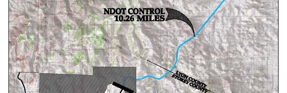
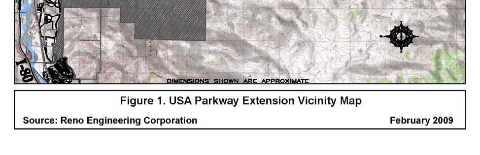
4 2.2 Proposed Agreement In December of 2008, the Tahoe-Reno Industrial Center submitted an Agreement to the Department of Transportation. The Agreement proposed by the developer of the Center would provide for the construction a roadway, the extension of USA Parkway to US 50. Several provisions of the agreement merit specific mention. They are: 1) The Center s developer will construct a new roadway extension, Minor Rural Arterial, approximately 13.5 miles (need limits) in length within 24 months land acquisition, design, construction and inspection. The Department would then receive ownership and maintenance responsibility for the entire parkway. However, recently the length of the extension was changed to miles since Storey County will now be maintaining the portion within its boundary (see Figure 1). 2) After the roadway extension is completed the Department of Transportation is to pay $40 million to the developer of the Center for the land and roadway improvements. 3) The roadway design and development process will not be required to meet Department highway standards and procedures. 4) The developer may terminate Agreement for any or no reason while the Department cannot terminate agreement. 5) The Agreement provides no warranty for cost estimates; if the construction bids are too high there will be no construction. 6) The Department will not have authority to approve or disapprove construction plans or the actual construction. Department construction inspection may be done for review and comment only. Additionally, the Department will not have any say regarding supplies and materials, which means that the Department cannot require materials from its Qualified Products List to be used. 7) Department will assume all operating and maintenance costs and the Nevada Highway Patrol will assume enforcement. 4


5 8) 5
6 Department will pay all deed transfer cost. Deed escrow will be open for a maximum of five years regardless whether the roadway construction in complete. 9) Any Department requested changes in construction plans will be altered by change orders in the Agreement with the Department bearing the cost. 10) The Agreement duration is 60 months or until construction is complete. 3.0 SILVER SPRINGS AIRPORT Lyon County owns and manages the Silver Springs Airport through a long term lease with the Silver Springs Airport, LLC. It is located along US 50 just west of US 95A. A Southern Pacific rail spur intersects US 50 about two miles east of the airport. The Silver Springs Airport is sufficient for a Transport Classification, Design Group II. Since 2001, with Lyon County sponsorship, $4,844,063 in FAA and State funded capitol improvements have been made on the airport. It now has a 6,600 by 75 foot runway, lighted 24-hours a day with a parallel taxiway, 300 foot overruns at each end of the runway, paved access road, expanded tie downs, all weather observation system, precision approach pilot indicators, runway end indicator lighting, rotating beacon and perimeter fencing. The airport also contains a 14 unit hangar building, restroom facilities and pilot s lounge. Fire suppression water lines were installed in 2008 and a fueling facility is planned for The county and the Silver Springs Airport, LLC are interested in enlarging the airport to serve neighboring counties (Storey and Churchill) to provide corporate/business jet services, air cargo service, charter aircraft and eventually some commercial passenger service. In order to accommodate Design Group III, B-737, B757, A300, etc. the runway, taxiway, safety areas, blast pads, etc. need to be lengthened and widened, and the runway strengthened. Additional taxiways will need to be constructed. Facilities for passenger and cargo terminals, crash, fire and rescue, maintenance, refueling parking, control tower, etc will be needed. Lyon County expects to have an Airport Master Plan completed in 2010 that will forecast air travel, and identify and program needed improvements over the next several years. The County will then apply for Airport Capital Improvement grants from the Federal Aviation administration to help upgrade the airport. To assess likely impacts of the airport improvement on the development of the Tahoe Reno Industrial Center, the nature of air freight needs to be explored. The 2010 Master Plan will analyze this topic and many others. In addition, the Silver Springs Specific Community Plan identifies large areas surrounding the airport for employment mixed use that enables development of corporate/business offices along US 50 and south of the airport. The USA Parkway Extension link will provide a vital access between the Silver Springs Airport/Tahoe- Reno Industrial Park and the Reno-Sparks Area for commerce, employment and tourism. For this study of the USA Parkway Extension, some general comments will be made pertaining to Tahoe-Reno Industrial Center. Air freight is generally considered break bulk wherein the freight is organized in small units rather than the 40 foot containers that is typical of oceanic and coastal shipping or even interstate trucking. Air freight is more characteristic of the following: mail and message packages; financial, insurance, real estate, and legal documents; medical supplies (especially serums and organs); electronic and computer replacement components for active critical systems, and critical equipment parts. In sum, aircraft is used for most of the high values items where quick delivery is required. The likely impact of the Silver Springs Airport development on the Tahoe-Reno Industrial Center will be the warehousing of items like computer and other electronic parts. 6
7 Because the origins or destinations of most documents will be the Reno-Sparks area; consequently, the transportation of documents is less conducive for Tahoe-Reno Industrial Center unless FedEx or UPS actually relocate distribution facilities to the Center property. There is also the likelihood that some warehouse shipments from Fernley would use the upgraded Silver Springs Airport. For example, the Amazon Warehouse in Fernley deals with smaller item orders, in contrast to their north Reno Warehouse that deals with larger shipments, will be more likely to use trucks. If the smaller items from Fernley need to be shipped long distances overnight, i.e. East Coast, then the Silver Springs Airport would be very helpful. 4.0 TRAVEL FORECASTS 4.1 Background Most of the current access is through the I-80 Interchange with USA Parkway. The Annual Average Daily Traffic (AADT) on I-80 just west of USA Parkway Interchange is approximately 24,000 of which 6,300 (26.3%) are heavy trucks (four of more axles) and 960 (4.0%) are light trucks. On USA Parkway just south of the interchange, counts in December, 2009, revealed considerable truck traffic with a count of 811 (17.8%) were heavy trucks and 512 (11.3%) were light trucks out of an ADT of Travel forecasts are a fundamental requirement for determining the need for a new roadway or an expansion of an existing one as well as conducting a Cost-Benefit Risk Analysis. Absent travel forecasts it is impossible to determine the value of a facility in quantifiable terms let alone determine the design criteria for its construction. 7
8 In most cases the development of travel forecasts for a roadway requires current and historical traffic volumes and vehicle characteristics data for the region including all parallel and intersecting routes. Comprehensive land use plans for current and future years, employment and residential statistics, population estimates, and origin-destination matrices are also important pieces of the information puzzle. In most instances much of this data is contained in regional travel demand models which are routinely updated in a cooperative and transparent process by representatives of the regional governments. Unfortunately, the proposed roadway falls outside the boundaries of the regional travel demand models available from the Carson Area Metropolitan Planning Organization (CAMPO) and from the Washoe County Regional Transportation Commission. Consequently, traffic forecasts for the proposed roadway are problematic considering the dearth of data available. Therefore the following narrative discusses the facts, methodology, and assumptions used to develop the travel forecasts that are intended to serve as the foundation for Cost-Benefit Risk Analysis for the USA Parkway extension to US Facts USA Parkway is currently constructed as a 4-lane facility from it s junction with I-80 southward for approximately 3.6 miles. Access to the area is limited to the USA Parkway Interchange and the Patrick Interchange on I-80. Current and historical traffic volume and vehicle classification data are available for I-80, US 50, and US 95 alternate (US 95A). Land use data including employment statistics are available for the current and proposed development of the Tahoe-Reno Industrial Center serviced by USA Parkway. The only current logical route for employees of Center that reside south of USA Parkway includes using the link of US 95A north of the junction of US 50. The extension of USA parkway would also likely provide a shorter travel time for travelers with origin-destinations south of the junction of US 50/US 95A and west of the USA Parkway Interchange on I Methodology A linear regression analysis was performed for US 95A north of it s junction of US 50 using the most recent ten years of data. The R-Squared was 0.96 which indicates a high degree of linearity and a subsequent high degree of confidence that traffic on this segment will likely follow the same pattern of growth in the future absent significant changes in land use or development of alternate routes that might affect travel patterns. The forecast volumes resulting from the regression analysis on this segment served as the foundation for predicting future total demand north of the junction with an origin-destination south, west, and east of the junction. The proportion of vehicles on US 95A north of the junction with US 50 that are coming from or going to the east, west and south of the junction of US 50 was derived from a manual turning movement count conducted for the am and pm peak hours in May of The proportion of total trips from each direction going to or coming form US 95A north of the junction estimated to have an origin-destination west of Fernley that would divert to the USA Parkway extension are discussed in the Assumptions subsection. These proportions were used in conjunction with the distribution derived from the turning movement data to determine the total proportion of trips with an origin-destination west and south of Fernley. The Design Hour Volume and Directional split were estimated based on data from the Department s continuous counter (ATR) located on US 50A west of its junction with US 50. The Annual Average Daily Truck Traffic and Design Hour Truck Volumes were derived based on a vehicle classification count conducted for 7 consecutive days in June 2005 on US 95 alternate north of the junction with US 50. 8
9 4.4 Traffic Data The traffic data that was use for this report includes estimates for 2010 Annual Average Daily Traffic (AADT) of 2,650, which is expected to grow to 4,120 in Of these daily estimates approximately 9% will be trucks. There were preliminary estimates for 2030 for many roadways in Lyon County provided to the county by Fehr & Peers in The estimate, making use of the Institute of Transportation Engineers (ITE) trip generation rates, for the southern end of the USA Parkway (at US 50) was approximately 26,500 to 40,300, which is of course much higher than the Department s estimate. The difference between this estimate and the one use for this analysis will need to be addressed in the near future. Recently, a forecast by PBS&J in 2009 for USA Parkway just south of the interchange with I-80 estimated a range for AADT of 22,200 to 39,300 for the year Assumptions The most questionable portion of the analysis is contained in the assumptions on the proportion of trips currently on US 95A south, US 50 west, and US 50 east of the junction that may have an origin-destination west of Fernley and that may benefit from an extension of the USA Parkway. Absent any specific information on these distributions the following assumptions were made: (1) One third (33%) of the trips on US 50 west of the junction of US 95A were assumed to have an origin-destination west of Fernley and 100 percent of these were assigned to USA parkway extension in the future. (2) One half (50 %) of the trips on US 95A south of the junction of US 50 were assumed to have an origin-destination west of Fernley and 100 percent of these were assigned to USA parkway extension in the future. (3) One tenth of the trips on US 50 east of the junction of US 95 alternate were assumed to have an origin-destination west of Fernley and 100 percent of these were assigned to USA parkway extension in the future. The diversion of truck traffic was assumed to mirror this diversion of total traffic. Absent information to the contrary, the new employment that will be attracted to the USA Parkway traffic analysis zone was assumed to mirror the current distribution of employees as reflected in existing travel patterns. Should the Department become aware of new residential developments in the area south of the junction of US 50 and US 95A or if origin-destination studies are conducted that challenge the assumed distributions, then the travel estimates provided in this analysis would require refinement. 5.0 QUANTITATIVE ANALYSIS 5.1 Benefits and Costs The road user benefits and costs utilized for the following cost-benefit analysis are based on cost data and factors used by the consultant that determined B/C ratios for Department s major projects. User Time Savings Once USA Parkway is fully built from I-80 through to US 50, the distance between Reno and Silver Springs will be reduced by about 10 miles. It is believed that most of the travel between these two locations will use the new USA Parkway. The average velocity on the existing route on US 95A, through Fernley then on I 80, is 60 mph. The new USA Parkway will 9
10 have a posted speed limit of 50 mph so that was chosen for the average velocity. The projected Average Daily Traffic (ADT) is 2,650 in Time values for users are determined by FHWA guidelines. The local, Reno-Sparks area road users time value is $9.60 per hour, and the business and truck drivers value is $30.74 per hour. The existing route is about 28 miles long and the new USA Parkway will be about 18 miles long. About six minutes will be saved off each trip utilizing the new route. After incorporating the mix of users, daily traffic, and for the whole year, about $$670,000 of saving will occur in the first year. Extending the expected traffic numbers through 20 years, the annual savings will rise to over $1,000,000 in today s dollars. User Fuel The shorter distance of required travel using USA Parkway Extension versus the Fernley route, would save about 10 miles of travel. Based on Department ADT estimates and FHWA total fleet average fuel mileage, about $1,200,000 is saved the first year. User Emissions Based on the rates of COx at $130/ton, NOx at $54,344/ton, and HC at $7,796/ton, the reduction of emissions were calculated. Based on the difference to distance traveled, and the speeds, the following dollar value was determined. The first year savings due to reduced emissions was estimated to be $3,387,016. Maintenance Costs In comparing current Department roads to the potential maintenance activities that USA Parkway will experience, US 95A between Silver Springs and Fernley, all of SR 341, and all of SR 342 were examined. The past three-year average per lane mile of maintenance and operations costs were: US 95A $8,361 SR 341 $15,714 SR 342 $20,256 Since the elevation of USA Parkway Extension is higher then US 95A but lower then SR 341 and SR 342, a one-half weighting was given to US 95A, one quarter to each SR 341 and SR 342. The estimated annual maintenance cost of USA Parkway will be $13,173 per centerline mile for a first year cost estimated at $135,681. A two inch overlay is modeled at 10 and 20 years of age for USA Parkway. The estimated cost of the overlay is just over $3.8 million. Safety Three years of actual accident data was analyzed on the route between Silver Springs and USA Parkway Interchange through Fernley. The crash rates (fatal, injury and property damage only) for I-80, SR 427 (through Fernley) and US 95A south to US 50 were determined. Accidents rates on USA Parkway were modeled as 3.6 miles of urban minor arterial and 16.4 miles of rural arterial. The crash rates were based on statewide averages for these functional classes of highways. The next step removed the 2,650 AADT from I-80, SR 427 and US 95A, and then determined the reduction in fatalities, injuries and property damage only. This was followed by adding the 2,650 trips per day to the parkway. 10
11 Because of the very low crash rates on I-80, the total crashes are expected to increase on the USA Parkway route versus the existing route through Fernley. The initial annual cost of the increased accidents was calculated to be just over $2 million. This amount is based on values from the National Safety Council and a 1991 Urban Institute/FHWA study. The cost of a death is $4,474,000, and injury accident is $100,000, and property damage only of $8,365. B/C Ratio The transportation benefits over 20 years, in today s dollars, total to about $74,600,000. The estimated capital costs are the terms of the agreement with Department, which is set at $40 million. The result of this analysis show that the extension to the parkway benefit/cost ratio is R/W Cost Tahoe-Reno Industrial Center currently own most of the 18 miles of Right of Way for USA Parkway. The Center will use their currently owned right-of-way for the proposed alignment of USA Parkway. The un-owned right-of-way will need to be purchased. Among other owners, right-of-way will need to be purchased from BLM. The Department Right of Way division estimates the total cost of these purchases to be about $1,000,000. However, the rightof-way is included in the $40 million according to the proposed agreement; consequently, it not included in the B/C ratio. 2.3 Economic Development The real value of this project is in allowing for the development of the RTIP. Based on forecasts published in Tahoe-Reno Industrial Center Fiscal Impact Analysis prepared by Fox Consulting in November 1999, and Which One Does What? An Economic Examination of Two Northern Nevada Industrial Developments prepared by Nevada Commission on Economic Development and State of Nevada Demographer in February 2002, Estimates were made for the economic benefit of the Development and USA Parkway to Nevada. The Fox estimates revenues to state and local governments generated from the development. The Nevada Commission estimates net impact on local Gross Product. After analyzing the relationship of the Gross Nevada Product to State of Nevada General Fund revenue, it was determined that the two reports show comparable growth rates and impacts to state government. In order for the Tahoe-Reno Industrial Center to realize the growth predicted in the two reports, annualized growth must be about 18% through at least Bases on current State of Nevada Demographer estimates, it appears that the Center is currently meeting the growth expectations predicted in both report 1. It is still believed that Center can continue to grow at the expected 18% rate for some time to come. However, with the current major economic recession that is international in scope as well as national, statewide and local, it is difficult to assume the 18% grow rate will continue for the next several years. Since the decision at hand for the Department is weather or not to enter an agreement to build and assume responsibility for the extension of USA Parkway, the rest of this section will try to focus on the differences that the USA Parkway will create. This Tahoe-Reno Industrial Center can become fully developed without the completion of USA Parkway. However, with the completion of USA Parkway, Center should be able to develop quicker, and should allow its customers more benefits. By allowing Center to offer 11
12 more benefits to its customers, Center will be more competitive and should a more profitable mix of customers. That should translate into more tax revenues to the state. Based on estimates provided by Reno Engineering (employed by the Center), the total acres developed in the center through 2030 without the parkway extension would be about 5,000 acres. Total acreage build out with the USA Parkway extension is estimated to be 11,500 acres according to the Reno Engineering estimates. Using state revenue per acre derived from Fox Consulting report, this would amount to about $20,000,000 difference in state revenue in Through 2030, the cumulative difference in revenue would be about $200,000,000. This is revenue only. No attempt has been made to account for higher state expenses associated with economic development. The economic impact of the parkway extension reported above is interesting. By providing access to a generally under developed area, Silver Springs Stage Coach, the Tahoe- Reno Industrial Center would accelerate the build-out acreage by 130%. This implies 6500 acres from the Reno-Sparks will be relocated to Center through How likely is that relocation? Given the proximity of the Center to the Reno-Sparks Area and the subsequent economic interaction compared with the proximity to the greater Silver Springs area and the potential economic interaction, it is difficult to understand how the parkway extension would accelerate the develop by the 130%. With the additional development, Lyon County would need to provide considerable public infrastructure and services. How much economic benefit to Lyon County will accrue from the Center? Given the current economic situation, such determinations are difficult to forecast. 6.0 QUALITATIVE ANALYSIS 6.1 Public-Private-Partnerships These partnerships are legal arrangements between public agencies and private entities that allow for greater participation in transportation project development and funding by the private sector. The partnerships provide a means for the private entities to assume a degree of risk, especially financially, for the transportation projects. The level of risk is typically associated with the opportunity for income available to the private entity. The general types of partnerships include: Design-build Design-Build-Operate-Maintain Design-Build-Finance-Operate Lease Develop Operate In the case of the USA Parkway Extension, the proposed Tahoe-Reno Industrial Center agreement is the design-build variety. The primary purpose for such partnerships is for the public and private entities to share costs, risks and benefits of a particular transportation project. The Public-Private-Partnerships are not to be a vehicle to circumvent federal and state regulations/laws. 6.2 Right-of-Way Issues The are three issues that might provide considerable risk for Department, namely, the Uniform Act, Bureau of Land Management (BLM) acquisitions and the Setting of Just Compensation. 12
13 The Tahoe-Reno Industrial Center developer must follow the Uniform Act on all acquisitions. This will be challenging if they are looking to cut corners and take short cuts. With the resent passing of the Peoples Initiative to Stop the Taking of Our Land (PISTOL) and the FHWA issues with Local Public Agencies and Stewardships, the Department would likely lose credibility. There are several BLM parcels that will be impacted. Typically, due to the federal requirements, these can be very time consuming acquisitions. Department required by FHWA to set just compensation for all property acquisitions when a local public agency has been delegated acquisition authority. The Developer will need to submit all appraisals and reviews to the Department so just compensation is set for each parcel, prior to any acquisitions. 6.3 Environmental Issues Segments of the public will be unhappy if a state highway is constructed without following present standard Department practices. Several likely concerns would not be analyzed i.e. wildlife, wetlands, social disruption and archeology, to determine whether mitigation is in order. The proposed agreement will undoubtedly be viewed by some as a veiled attempt by the Department to avoid environmental mitigation. 6.4 Prevailing Wages Prevailing wages, this would result in an easy argument in court that this proposed agreement is a veiled attempt by the Department to avoid prevailing wage requirements. This item is more urgent than the others because the others require something to happen or go wrong, then legal action can take place. With this item, avoiding prevailing wages is the wrong. In fact, the proposed agreement could be in court on this topic before or soon after construction would begin. 6.4 Public Involvement In the past the Department has found it difficult to successfully develop highway projects without effective public involvement. The Department has invested considerable resources to develop favorable relations with the public during the US 50 Corridor Study. An attempt to avoid an open project development process with the parkway extension will most likely damage the credibility of the Department significant. 6.4 Agreement Issues The draft agreement allows very little risk to Tahoe-Reno Industrial Center, at most design costs. For the Department there considerable risk for several reasons: 1) roadway may not be constructed to Department standards, 2) the Department cannot assure the quality of materials and supplies, 3) segments of the public will undoubted be unhappy to see a state highway constructed without following present standard Department practices. 4) The Center can terminate the agreement, but the Department cannot. 6.5 System Continuity From a highway system context, a roadway that connects an interstate highway to a US route as originally proposed is attractive and a state highway designation would be appropriate. The development and construction of such a highway would need to be weighed against other 13
14 demands on the Department construction and maintenance budgets. However, with the recent change, the new state highway would have to be a spur (US 50 to Lyon/Storey border) that will serve primarily one land-owner. If the northern 7 miles is owned and maintained by Storey County, then logic would suggest that the southern 10 miles be owned and maintained by Lyon County. 6.6 Funding Under the terms of the Agreement, the Department will provide $40 million for the construction of a new State Highway. Over then next eight years approximately $6 billion statewide is needed for capacity projects within the next decade, while the Department of Transportation s preservation program will under funded by $1.7 billion in 2012 without a significant increase in funding. While the Department does have a category of funding that can support economic development, there are two major drawbacks. First, it was developed to support smaller projects so there is only $4 million available annually. Second, this funding can also be used to support projects not related to economic development. There are major funding categories that could be applied to this project; however, the USA Parkway Extension will need to compete against major capacity projects. 6.7 Cost Effectiveness To say that there is a shortfall in funding for the Department is a severe under statement. The extension of the USA Parkway is considered a system expansion project and must compete against the capacity projects in our large urban areas. For example, in Reno there project on US 395 to widen it northbound between Moana and I-80. This expansion is estimated at $70 million that will affect approximately 75,000 AADT of present traffic. The parkway extension will cost $40 million as per proposed agreement and will impact an initial estimated 2650 AADT. Given the current and initial AADT and length of these two projects the US 395 will cost approximately $0.90/VMT and the parkway extension will cost about $3.60/VMT. The basic policy issue facing the Department is to determine the most cost-effective use of $40 million at the present time. 6.8 Transportation Plan As far as we have determined, the USA Parkway Extension does not appear on any approved transportation planning document. Consequently, before any funding action could be initiated, the Extension would need to be added to a regional plan. However, the USA Parkway has been given a designation of State Route 439, pending an acceptable agreement. 7.0 MAJOR FINDINGS There are numerous major findings associated with this Cost-Benefit Risk Analysis for extending the USA Parkway south to US 50 and the agreement proposed by the Tahoe-Reno Industrial Center. The B/C ratio for the USA Parkway Extension was found to be about 1.86, based on the $40 million purchase price in the proposed December agreement. It should also be remembered that according to the proposed agreement, the USA Parkway Extension will not be built to the Department s existing standards and practices. 14
15 There is considerable direct and indirect economic benefit to local and state governments for the Center. However, the costs for public infrastructure and services required to support the resulting secondary economic impact apparently has not been estimated. The impact of the extension claiming to accelerate the build-out by 130% needs to be investigated before funds are applied to the extension. There were preliminary estimates for 2030 for many roadways provided to Lyon County by a consultant. The estimate for the southern end of the USA Parkway was much higher then the estimate provided by the Department. There has not been sufficient time or resources to address the difference. One significant risk is that the developer will avoid the federal and state environment requirements. In the past the Department has been challenged regarding environmental issues. In recent years it has focused on cooperating with local, regional and national resources agencies to address concerns and developing mitigation strategies. To have these items ignored, the Department would lose creditability and could be subjected to lawsuits. The lack of Department public hearings/involvement will be a significant risk to the loss of excellent Department creditability that developed during the US 50 Corridor Study. Another major risk is avoiding the use of prevailing wages, which would likely lead to lawsuits. The Department has exerted considerable effort to maintain good relations with the contracting industry and does not want to jeopardize those relations The assumptions used for the development of Tahoe-Reno Industrial Center create a substantial risk for the Department. If the Department invests in the extension of the parkway, there is a risk that the development will not occur as expected. The fact that the Department standards and materials requirement are not required will create a significant risk that the extension will require more maintenance and preservation than normally expected from a Minor Arterial. There are some right-of-way risks that could reflect badly on the Department. The present financial situation of the Department is not good. Through 2016 there is not sufficient funding to meet the urban capacity needs. From a cost effectiveness perspective, investing $40 million in the US-395 Northbound Auxiliary Lane project in the short term will be a more cost effectiveness use of that money. Given the fact that the Department s highway preservation program is grossly under funding, the $40 million would be better spent on preservation projects. Finally, the USA Parkway Extension does not appear in planning documents. 8.0 RECOMMENDATIONS There are several recommendations to consider. While there is a favorable B/C ratio (1.86 per the $40 million price), the Department should NOT approve the December agreement as written. There are too many significant risks identified in Section 7.0, Major Findings. Before the Department reconsiders the proposed agreement, the major risk concerns will need to be addressed. The concept of funding the extension could be revisited when the Silver Springs Airport Master Plan is completed in The master plan should reveal considerable information about potential and likely airport related cargo activity, and growth in development near the airport. Since the extension would support local economic activity, it is recommended that Lyon County take responsibility for the portion of the extension within its jurisdiction and that Story County be responsible of the northern portion of the parkway, within its boundaries. 15
16 The final comment is that the Department could consider loaning the $40 million to Lyon County for the construction of the Extension and then, after 5 years (or so), have Lyon County begin making payments to pay back the Department with reasonable interest over the next 10 years (or so). The 5 year grace period would allow Lyon County time to begin receiving revenue from the Center s development to repay the Department. 9.0 APPENDIX REFERENCES Tahoe-Reno Industrial Center Fiscal Impact Analysis prepared by Fox Consulting in November Which One Does What? An Economic Examination of Two Northern Nevada Industrial Developments prepared by Nevada Commission on Economic Development and State of Nevada Demographer in February Mike Lawson, Department of Transportation Memorandum to Jeff Lerud, Design Designation for USA Parkway North of US 50, January 9,
Aviation, Rail, & Trucking 6-1
 6-1 This chapter describes the services, facilities, and condition of air, rail, and trucking as components of the transportation system. These three intermodal areas have an impact on the factors to be
2009 Muskoka Airport Economic Impact Study
 2009 Muskoka Airport Economic Impact Study November 4, 2009 Prepared by The District of Muskoka Planning and Economic Development Department BACKGROUND The Muskoka Airport is situated at the north end
Business Growth (as of mid 2002)
") Page 1 of 6 Planning FHWA > HEP > Planning > Econ Dev < Previous Contents Next > Business Growth (as of mid 2002) Data from two business directories was used to analyze the change in the number of businesses
Page 1 of 6 Planning FHWA > HEP > Planning > Econ Dev < Previous Contents Next > Business Growth (as of mid 2002) Data from two business directories was used to analyze the change in the number of businesses
FNORTHWEST ARKANSAS WESTERN BELTWAY FEASIBILITY STUDY
 FNORTHWEST ARKANSAS WESTERN BELTWAY FEASIBILITY STUDY EXECUTIVE SUMMARY The 2030 Northwest Arkansas Regional Transportation Plan developed by the Northwest Arkansas Regional Planning Commission (NWARPC)
Vista Field Airport. Master Plan Update. February, Prepared for: Port of Kennewick One Clover Island Kennewick, Washington
 Vista Field Airport February, 2006 Prepared for: Port of Kennewick One Clover Island Kennewick, Washington 99336 Prepared by: J-U-B ENGINEERS, Inc. 2810 W. Clearwater Avenue, Suite 201 Kennewick, Washington
MONTEREY REGIONAL AIRPORT MASTER PLAN TOPICAL QUESTIONS FROM THE PLANNING ADVISORY COMMITTEE AND TOPICAL RESPONSES
 MONTEREY REGIONAL AIRPORT MASTER PLAN TOPICAL QUESTIONS FROM THE PLANNING ADVISORY COMMITTEE AND TOPICAL RESPONSES Recurring topics emerged in some of the comments and questions raised by members of the
CHAPTER 1 EXECUTIVE SUMMARY
 CHAPTER 1 EXECUTIVE SUMMARY 1 1 EXECUTIVE SUMMARY INTRODUCTION William R. Fairchild International Airport (CLM) is located approximately three miles west of the city of Port Angeles, Washington. The airport
Section 106 Update Memo #1 Attachment D. Traffic Diversion & APE Expansion Methodology & Maps
 Section 106 Update Memo #1 Attachment D Traffic Diversion & APE Expansion Methodology & Maps I-65/I-70 North Split Interchange Reconstruction Project (Des. Nos. 1592385 & 1600808) Traffic Diversion and
ESTIMATION OF ECONOMIC IMPACTS FOR AIRPORTS IN HAWTHORNE, EUREKA, AND ELY, NEVADA
 TECHNICAL REPORT UCED 97/98-14 ESTIMATION OF ECONOMIC IMPACTS FOR AIRPORTS IN HAWTHORNE, EUREKA, AND ELY, NEVADA UNIVERSITY OF NEVADA, RENO ESTIMATION OF ECONOMIC IMPACTS FOR AIRPORTS IN HAWTHORNE, EUREKA
Economic Impact of Kalamazoo-Battle Creek International Airport
 Reports Upjohn Research home page 2008 Economic Impact of Kalamazoo-Battle Creek International Airport George A. Erickcek W.E. Upjohn Institute, erickcek@upjohn.org Brad R. Watts W.E. Upjohn Institute
According to FAA Advisory Circular 150/5060-5, Airport Capacity and Delay, the elements that affect airfield capacity include:
 4.1 INTRODUCTION The previous chapters have described the existing facilities and provided planning guidelines as well as a forecast of demand for aviation activity at North Perry Airport. The demand/capacity
Westover Metropolitan Airport Master Plan Update
 Westover Metropolitan Airport Master Plan Update June 2008 INTRODUCTION Westover Metropolitan Airport (CEF) comprises the civilian portion of a joint-use facility located in Chicopee, Massachusetts. The
Milton. PeterPrinceAirportislocatedinSantaRosaCounty, approximatelythreemileseastofmilton.
 Milton GeneralAviationAirport PeterPrinceAirportislocatedinSantaRosaCounty, approximatelythreemileseastofmilton. Existing Facilities Peter Prince Airport is served by one runway, Runway 18/36, 3,700 feet
JOSLIN FIELD, MAGIC VALLEY REGIONAL AIRPORT DECEMBER 2012
 1. Introduction The Federal Aviation Administration (FAA) recommends that airport master plans be updated every 5 years or as necessary to keep them current. The Master Plan for Joslin Field, Magic Valley
FORECASTING FUTURE ACTIVITY
 EXECUTIVE SUMMARY The Eagle County Regional Airport (EGE) is known as a gateway into the heart of the Colorado Rocky Mountains, providing access to some of the nation s top ski resort towns (Vail, Beaver
CHAPTER 3 ALTERNATIVES CONSIDERED
 CHAPTER 3 ALTERNATIVES CONSIDERED 3.0 ALTERNATIVES The 2010 Stevensville Airport Master Plan contained five (5) airside development options designed to meet projected demands. Each of the options from
Draft Concept Alternatives Analysis for the Inaugural Airport Program September 2005
 Draft Concept Alternatives Analysis for the Inaugural Airport Program September 2005 Section 3 - Refinement of the Ultimate Airfield Concept Using the Base Concept identified in Section 2, IDOT re-examined
Document prepared by MnDOT Office of Aeronautics and HNTB Corporation. MINNESOTA GO STATE AVIATION SYSTEM PLAN
 LAST UPDATE JULY 2013 Acknowledgements The preparation of this document was financed in part by a grant from the Federal Aviation Administration (Project No: 3-27-0000-07-10), with the financial support
Draft Concept Alternatives Analysis for the Inaugural Airport Program September 2005
 Section 10 Preferred Inaugural Airport Concept 10.0 Introduction The Preferred Inaugural Airport Concept for SSA was developed by adding the preferred support/ancillary facilities selected in Section 9
Airport Planning Area
 PLANNING AREA POLICIES l AIRPORT Airport Planning Area LOCATION AND CONTEXT The Airport Planning Area ( Airport area ) is a key part of Boise s economy and transportation network; it features a multi-purpose
Wyoming Valley Airport Proposed Improvements. Presented June 26, 2012 By The WBW Airport Advisory Board & FBO
 Wyoming Valley Airport Proposed Improvements Presented June 26, 2012 By The WBW Airport Advisory Board & FBO Contents Purpose of meeting Airport overview Background of proposed improvements SWOT analysis
FORT LAUDERDALE-HOLLYWOOD INTERNATIONAL AIRPORT ENVIRONMENTAL IMPACT STATEMENT DRAFT
 D.3 RUNWAY LENGTH ANALYSIS Appendix D Purpose and Need THIS PAGE INTENTIONALLY LEFT BLANK Appendix D Purpose and Need APPENDIX D.3 AIRFIELD GEOMETRIC REQUIREMENTS This information provided in this appendix
Executive Summary. MASTER PLAN UPDATE Fort Collins-Loveland Municipal Airport
 Executive Summary MASTER PLAN UPDATE Fort Collins-Loveland Municipal Airport As a general aviation and commercial service airport, Fort Collins- Loveland Municipal Airport serves as an important niche
PULLMAN-MOSCOW REGIONAL AIRPORT Runway Realignment Project
 PULLMAN-MOSCOW REGIONAL AIRPORT Runway Realignment Project GENERAL AIRPORT INFORMATION AIRPORT USERS Airport ownership: Public, owned by the Pullman-Moscow Regional Airport Board Year opened: February
Table of Contents. Overview Objectives Key Issues Process...1-3
 Table of Contents Chapter One Introduction Overview...1-1 Objectives...1-1 Key Issues...1-2 Process...1-3 Chapter Two Inventory of Existing Conditions Airport Setting...2-1 Locale...2-1 Airport Surroundings...2-5
The Economic Impact of Tourism in North Carolina. Tourism Satellite Account Calendar Year 2015
 The Economic Impact of Tourism in North Carolina Tourism Satellite Account Calendar Year 2015 Key results 2 Total tourism demand tallied $28.3 billion in 2015, expanding 3.6%. This marks another new high
Fort Wayne International Airport Master Plan Study. Executive Summary
 Fort Wayne International Airport Master Plan Study Executive Summary March 2012 Introduction Airport Background Forecast of Aviation Activity Development Plans Recommended Airfield & Access Development
CHAPTER 1: INTRODUCTION
 CHAPTER 1: INTRODUCTION Purpose and Scope The information presented in this report represents the study findings for the 2016 Ronan Airport Master Plan prepared for the City of Ronan and Lake County, the
STAFF REPORT. Airport Land Use Plan Consistency Review: Santa Barbara Airport Master Plan. MEETING DATE: November 19, 2015 AGENDA ITEM: 7D
 STAFF REPORT SUBJECT: Airport Land Use Plan Consistency Review: Santa Barbara Airport Master Plan MEETING DATE: AGENDA ITEM: 7D STAFF CONTACT: Peter Imhof, Andrew Orfila RECOMMENDATION: Adopt findings
Tourism Satellite Account Calendar Year 2010
 The Economic Impact of Tourism in Georgia Tourism Satellite Account Calendar Year 2010 Highlights The Georgia visitor economy rebounded in 2010, recovering 98% of the losses experienced during the recession
The Economic Impact of Tourism in North Carolina. Tourism Satellite Account Calendar Year 2013
 The Economic Impact of Tourism in North Carolina Tourism Satellite Account Calendar Year 2013 Key results 2 Total tourism demand tallied $26 billion in 2013, expanding 3.9%. This marks another new high
The Economic Impact of Tourism in Maryland. Tourism Satellite Account Calendar Year 2015
 The Economic Impact of Tourism in Maryland Tourism Satellite Account Calendar Year 2015 MD tourism economy reaches new peaks The Maryland visitor economy continued to grow in 2015; tourism industry sales
DRAFT FINAL REPORT AIRPORT MASTER PLAN. Rifle Garfield County Airport Revised May 15, 2014
 DRAFT FINAL REPORT AIRPORT MASTER PLAN Rifle Garfield County Airport Revised May 15, 2014 As required by Paragraph 425.B(4) of FAA Order 5100.38C, Airport Improvement Program (AIP) Handbook: The preparation
Economic Impact of Tourism in Hillsborough County September 2016
 Economic Impact of Tourism in Hillsborough County - 2015 September 2016 Key findings for 2015 Almost 22 million people visited Hillsborough County in 2015. Visits to Hillsborough County increased 4.5%
Existing Airport System
 Introduction Rhode Island s Aviation System A strong relationship exists between Rhode Island s economy and aviation. In today s global market place, the state s system of commercial service and general
PLU Airport Master Plan Master Plan Advisory Committee (MPAC) Meeting #4 MASTER PLAN ADVISORY COMMITTEE (MPAC) - MEETING #4
 Meeting #4 MASTER PLAN ADVISORY COMMITTEE (MPAC) - MEETING #4") MASTER PLAN ADVISORY COMMITTEE (MPAC) - MEETING #4 MASTER PLAN ADVISORY COMMITTEE (MPAC) MEETING #4 AGENDA & ACTION ITEMS Date/Time: Location: Monday, March 19, 2018 from 1:30-3:30 p.m. Thun Field Airport
MASTER PLAN ADVISORY COMMITTEE (MPAC) - MEETING #4 MASTER PLAN ADVISORY COMMITTEE (MPAC) MEETING #4 AGENDA & ACTION ITEMS Date/Time: Location: Monday, March 19, 2018 from 1:30-3:30 p.m. Thun Field Airport
Why are the underground fuel tanks being removed and replaced with above ground tanks?
 AIRPORT/CITIZEN FAQ This list of Frequently Asked Questions (FAQs) with responses are provided to share information related to airport topics with the Citizens of Georgetown. The questions / responses
ECONOMIC IMPACT STUDY OF CALIFORNIA AIRPORTS
 ECONOMIC IMPACT STUDY OF CALIFORNIA AIRPORTS MARCH 1, 2013 Prepared for California Airports Council Prepared by Applied Development Economics 100 Pringle Avenue, Suite 560 Walnut Creek, California 94596
Subject Property Schuster St Las Vegas, NV SW Las Vegas Ind. LOCATION Distance to Seaport:
 Subject Property 6615 Schuster St Las Vegas, NV 89118 - SW Las Vegas Ind LOCATION Distance to Airport: 6.2 mi Distance to Seaport: 232.5 mi Distance to Rail Terminal: 6.7 mi Population 500 Mile Radius:
Flying Cloud Airport (FCM) Zoning Process: Informing a Mn/DOT Path Forward
 Zoning Process: Informing a Mn/DOT Path Forward") : Informing a Mn/DOT Path Forward A Review of the Flying Cloud Airport (FCM) Joint Airport Zoning Board (JAZB) Process and the Draft Airport Zoning Ordinance B A RPZ RPZ A B C Zone Chad E. Leqve Director
: Informing a Mn/DOT Path Forward A Review of the Flying Cloud Airport (FCM) Joint Airport Zoning Board (JAZB) Process and the Draft Airport Zoning Ordinance B A RPZ RPZ A B C Zone Chad E. Leqve Director
1.2 Corridor History and Current Characteristics
 SECTION 1 Description and Background of Study Area 1.1 Introduction This preliminary engineering report was prepared for the Alaska Department of Transportation and Public Facilities (ADOT&PF). It is part
2008 DEKALB COUNTY TRANSPORTATION PLAN (UPDATE)
") 2008 DEKALB COUNTY TRANSPORTATION PLAN (UPDATE) TABLE OF CONTENTS Introduction 1 Transportation Planning Activities 2 Identification of Problem Areas and Recommended Solutions 7 DeKalb County Projects
2008 DEKALB COUNTY TRANSPORTATION PLAN (UPDATE) TABLE OF CONTENTS Introduction 1 Transportation Planning Activities 2 Identification of Problem Areas and Recommended Solutions 7 DeKalb County Projects
The purpose of this Demand/Capacity. The airfield configuration for SPG. Methods for determining airport AIRPORT DEMAND CAPACITY. Runway Configuration
 Chapter 4 Page 65 AIRPORT DEMAND CAPACITY The purpose of this Demand/Capacity Analysis is to examine the capability of the Albert Whitted Airport (SPG) to meet the needs of its users. In doing so, this
SECTOR ASSESSMENT (SUMMARY): Transport, and Information and Communication Technology - Air Transport 1
: Transport, and Information and Communication Technology - Air Transport 1") Air Transport Connectivity Enhancement Project (RRP BHU 44239-013) SECTOR ASSESSMENT (SUMMARY): Transport, and Information and Communication Technology - Air Transport 1 Sector Road Map 1. Sector Performance,
Air Transport Connectivity Enhancement Project (RRP BHU 44239-013) SECTOR ASSESSMENT (SUMMARY): Transport, and Information and Communication Technology - Air Transport 1 Sector Road Map 1. Sector Performance,
Treasure Island Supplemental Information Report Addendum
 1 1 1 1 0 1 0 1 0 1 Treasure Island Supplemental Information Report Addendum Introduction Purpose The purpose of this Supplemental Information Report (SIR) Addendum is to determine if the current land
Agenda: SASP SAC Meeting 3
 Agenda: SASP SAC Meeting 3 Date: 04/12/18 Public Involvement Plan Update Defining the System Recommended Classifications Discussion Break Review current system Outreach what we heard Proposed changes Classification
SAN MARTIN BUSINESS PLAN COMMUNITY MEETING
 SAN MARTIN BUSINESS PLAN COMMUNITY MEETING Summary of Community Meeting Wednesday May 23, 2018 Santa Clara County Roads and Airports Department hosted a community meeting on Wednesday May 23 nd, 2018 from
Finance and Implementation
 5 Finance and Implementation IMPLEMENTATION The previous chapters have presented discussions and plans for development of the airfield, terminal, and building areas at Sonoma County Airport. This chapter
Lake Erie Commerce Center Traffic Analysis
 LOCATION: East of NYS Route 5 at Bayview Road Town of Hamburg Erie County, New York PREPARED BY: Wendel Companies 140 John James Audubon Parkway Suite 200 Amherst, New York 14228 January 2012 i ii Table
Stimulating Airports is Stimulating the Economy
 Stimulating Airports is Stimulating the Economy House of Commons Standing Committee on Finance Pre-budget 2010 Submission August 14 th, 2009 Executive Summary Atlantic Canada Airports Association s (ACAA)is
3. Aviation Activity Forecasts
 3. Aviation Activity Forecasts This section presents forecasts of aviation activity for the Airport through 2029. Forecasts were developed for enplaned passengers, air carrier and regional/commuter airline
The Economic Impact of Tourism in Maryland. Tourism Satellite Account Calendar Year 2016
 The Economic Impact of Tourism in Maryland Tourism Satellite Account Calendar Year 2016 County Results Washington County, Visitors Washington County Visitors (thousands) Year Overnight Day Total Growth
 Existing Conditions AIRPORT PROFILE Passenger Terminal Complex 57 air carrier gates 11,500 structured parking stalls Airfield Operations Area 9,000 North Runway 9L-27R 6,905 Crosswind Runway 13-31 5,276
SAMTRANS TITLE VI STANDARDS AND POLICIES
 SAMTRANS TITLE VI STANDARDS AND POLICIES Adopted March 13, 2013 Federal Title VI requirements of the Civil Rights Act of 1964 were recently updated by the Federal Transit Administration (FTA) and now require
CHAPTER 1 BACKGROUND AND PROPOSED ACTION
 CHAPTER 1 BACKGROUND AND PROPOSED ACTION 1.0 INTRODUCTION An Environmental Assessment (EA) evaluates the effects of a proposed Federal action on the surrounding environment and is prepared in compliance
Interstate 90 and Mercer Island Mobility Study APRIL Commissioned by. Prepared by
 Interstate 90 and Mercer Island Mobility Study APRIL 2017 Commissioned by Prepared by Interstate 90 and Mercer Island Mobility Study Commissioned by: Sound Transit Prepared by: April 2017 Contents Section
APPENDIX B: NPIAS CANDIDATE AIRPORT ANALYSIS
 APPENDIX B: NPIAS CANDIDATE AIRPORT ANALYSIS The National Plan of Integrated Airport Systems (NPIAS) is the Federal Aviation Administration s (FAA) national airport plan. The NPIAS includes nearly 3,500
Whangarei Airport. Prepared by Carine Andries 10/20173
 Whangarei Airport Prepared by Carine Andries 10/20173 March 2010 TABLE OF CONTENTS 1 2 3 INTRODUCTION... 3 AIRPORT ROLE AND FUNCTION... 3 AIRPORT FEATURES AND CAPACITY... 3 3.1 3.2 3.3 3.4 3.5 3.5.1 3.5.2
PURPOSE AND NEED (CONCURRENCE POINT 1) NEW CANADA ROAD PROJECT FROM STATE ROUTE 1 (U.S. HIGHWAY 70) TO U.S. INTERSTATE 40
 NEW CANADA ROAD PROJECT FROM STATE ROUTE 1 (U.S. HIGHWAY 70) TO U.S. INTERSTATE 40") PURPOSE AND NEED (CONCURRENCE POINT 1) NEW CANADA ROAD PROJECT FROM STATE ROUTE 1 (U.S. HIGHWAY 70) TO U.S. INTERSTATE 40 Project Description The primary purpose of this project is to improve the major
PURPOSE AND NEED (CONCURRENCE POINT 1) NEW CANADA ROAD PROJECT FROM STATE ROUTE 1 (U.S. HIGHWAY 70) TO U.S. INTERSTATE 40 Project Description The primary purpose of this project is to improve the major
Airport Master Plan Update June 15, 2017
 Airport Master Plan Update June 15, 2017 www.harveyfield.com The Master Plan is a 20-year plan to understand the needs of current and future users of the Airport. This is important to ensure that safe
Summary of Committee Discussion/Questions Metropolitan Transportation Services Senior Planner Russ Owen presented this item.
 Committee Report Business Item No. 2017-191 Transportation Committee For the Metropolitan Council meeting of September 13, 2017 Subject: Final Crystal Airport 2035 Long Term Comprehensive Plan (LTCP) Proposed
AVIATION. MichiganReportCard.com 5
 MichiganReportCard.com 5 GRADE C AVIATION OVERVIEW Michigan s 200+ airports bring $4.3 billion into the economy each year. The state s Tier 1 and Tier 2 airports were evaluated based on six key infrastructure
CATCODE ] CATCODE
![CATCODE ] CATCODE](/thumbs/82/85644630.jpg "CATCODE ] CATCODE") Runways. FAC: 1111 CATCODE: 111111 OPR: AFCEC/COS OCR: AF/A3O-A 1.1. Description. The runway is the paved surface provided for normal aircraft landings and take offs. Runways are classified as either Class
Runways. FAC: 1111 CATCODE: 111111 OPR: AFCEC/COS OCR: AF/A3O-A 1.1. Description. The runway is the paved surface provided for normal aircraft landings and take offs. Runways are classified as either Class
Chapter 1 Introduction
 Chapter 1 Introduction Introduction and Purpose The Airport Master Planning process evaluates an airport s physical facilities, establishes a forecast for future demand, and identifies a development plan
STUDY OVERVIEW MASTER PLAN GOALS AND OBJECTIVES
 INTRODUCTION An Airport Master Plan provides an evalua on of the airport s avia on demand and an overview of the systema c airport development that will best meet those demands. The Master Plan establishes
SouthwestFloridaInternational Airport
 SouthwestFloridaInternational Airport SouthwestFloridaInternationalAirportislocatedinLee CountyalongtheGulfCoastofSouthFlorida,tenmiles southeastofthefortmyerscentralbusinessdistrict. Theprimaryhighwayaccesstotheairportfrom
Lake Tahoe Airport Master Plan Public Meeting March 16, 2015
 Lake Tahoe Airport Master Plan Public Meeting March 16, 2015 What is an Airport Master Plan? a comprehensive study of an airport [that] usually describes the short, medium, and long term development plans
CHAPTER 4: ALTERNATIVES
 MSP Long Term Comprehensive Plan Update Metropolitan Airports Commission 4.1 INTRODUCTION CHAPTER 4: ALTERNATIVES Several alternatives were developed and evaluated based on their capability to meet the
MEMORANDUM. Lynn Hayes LSA Associates, Inc.
 MEMORANDUM To: Lynn Hayes LSA Associates, Inc. Date: May 5, 217 From: Zawwar Saiyed, P.E., Senior Transportation Engineer Justin Tucker, Transportation Engineer I Linscott, Law & Greenspan, Engineers LLG
1.0 Project Background Mission Statement and Goals Objectives of this Sustainable Master Plan
 TABLE OF CONTENTS CHAPTER 1 INTRODUCTION 10 Project Background 1-1 11 Mission Statement and Goals 1-1 12 Objectives of this Sustainable Master Plan 1-2 CHAPTER 2 INVENTORY 20 Airport Background 2-1 201
Burke Lakefront Airport (BKL) Master Plan Update
 Master Plan Update") Burke Lakefront Airport () Master Plan Update Public Workshop August 2, 2007 City of Cleveland Department of Port Control (DPC) City of Cleveland DPC Studies Currently In Progress Market Assessment & Feasibility
Burke Lakefront Airport () Master Plan Update Public Workshop August 2, 2007 City of Cleveland Department of Port Control (DPC) City of Cleveland DPC Studies Currently In Progress Market Assessment & Feasibility
Chapter 1: Introduction Draft
 Chapter 1: Draft TABLE OF CONTENTS 1... 4 1.6.1 Stakeholder Engagement Plan... 10 Chapter 1 Page 2 TABLE OF EXHIBITS Exhibit 1.1-1 ABIA Annual Growth Since 1993... 5 Exhibit 1.4-1: ABIA Location Map...
THIRTEENTH AIR NAVIGATION CONFERENCE
 International Civil Aviation Organization AN-Conf/13-WP/22 14/6/18 WORKING PAPER THIRTEENTH AIR NAVIGATION CONFERENCE Agenda Item 1: Air navigation global strategy 1.4: Air navigation business cases Montréal,
Silver Center Development USA Parkway & Highway 50 Silver Springs, Nevada
 O f f e r i n g M e m o r a n d u m Silver Center Development USA Parkway & Highway 50 Silver Springs, Nevada 25.7 Acres presented exclusively by Ron Cobb Principal Direct: (775) 329-4000 x103 Cell: (775)
Airport Master Plan Update June 15, 2017
 Airport Master Plan Update June 15, 2017 www.harveyfield.com The Master Plan is a 20-year plan to understand the needs of current and future users of the Airport. This is important to ensure that safe
Chapter 1 Introduction and Project Overview
 Chapter 1 Introduction and Project Overview Kittitas County in cooperation with the Federal Aviation Administration (FAA) is updating the Airport Master Plan for Bowers Field Airport (FAA airport identifier
Surveillance and Broadcast Services
 Surveillance and Broadcast Services Benefits Analysis Overview August 2007 Final Investment Decision Baseline January 3, 2012 Program Status: Investment Decisions September 9, 2005 initial investment decision:
REAUTHORISATION OF THE ALLIANCE BETWEEN AIR NEW ZEALAND AND CATHAY PACIFIC
 Chair Cabinet Economic Growth and Infrastructure Committee Office of the Minister of Transport REAUTHORISATION OF THE ALLIANCE BETWEEN AIR NEW ZEALAND AND CATHAY PACIFIC Proposal 1. I propose that the
TWENTY-SECOND MEETING OF THE ASIA/PACIFIC AIR NAVIGATION PLANNING AND IMPLEMENTATION REGIONAL GROUP (APANPIRG/22)
") INTERNATIONAL CIVIL AVIATION ORGANIZATION TWENTY-SECOND MEETING OF THE ASIA/PACIFIC AIR NAVIGATION PLANNING AND IMPLEMENTATION REGIONAL GROUP (APANPIRG/22) Bangkok, Thailand, 5-9 September 2011 Agenda
INTERNATIONAL CIVIL AVIATION ORGANIZATION TWENTY-SECOND MEETING OF THE ASIA/PACIFIC AIR NAVIGATION PLANNING AND IMPLEMENTATION REGIONAL GROUP (APANPIRG/22) Bangkok, Thailand, 5-9 September 2011 Agenda
Foregone Economic Benefits from Airport Capacity Constraints in EU 28 in 2035
 Foregone Economic Benefits from Airport Capacity Constraints in EU 28 in 2035 Foregone Economic Benefits from Airport Capacity Constraints in EU 28 in 2035 George Anjaparidze IATA, February 2015 Version1.1
Current and Forecast Demand
 Existing Facilities Jacksonville International Airport (JIA) is served by a number of airside and landside facilities. There are two runways that serve the airport in an open V configuration. The Annual
The Economic Impact of Tourism on Galveston Island, Texas
 The Economic Impact of Tourism on Galveston Island, Texas 2017 Analysis Prepared for: Headline Results Headline results Tourism is an integral part of the Galveston Island economy and continues to be a
Aviation Program Features by Category: Aircraft, Facilities, Personnel, and Cost for Fiscal Year
 Aviation Program Features by Category: Aircraft, Facilities, Personnel, and Cost for Fiscal Year 2008-09 Passenger Transport State Program Aircraft Facilities (Location) Personnel Area Health Education
FAA RECORD OF DECISION. Appendix D FINAL EIS ADDENDUM DOCUMENTS
 FORT LAUDERDALE-HOLLYWOOD INTERNATIONAL AIRPORT FAA RECORD OF DECISION Appendix D FINAL EIS ADDENDUM DOCUMENTS This appendix contains information that has been identified as having been inadvertently omitted
EB-5 STAND-ALONE PETITIONS AND EB-5 REGIONAL CENTER PETITIONS: WHICH ONE MAKES SENSE FOR MY PROJECT? Mona Shah, Esq. Yi Song, Esq.
 EB-5 STAND-ALONE PETITIONS AND EB-5 REGIONAL CENTER PETITIONS: WHICH ONE MAKES SENSE FOR MY PROJECT? By Mona Shah, Esq. Yi Song, Esq. An EB-5 investment can take one of two forms. The investor can invest
Memorandum. Roger Millar, Secretary of Transportation. Date: April 5, Interstate 90 Operations and Mercer Island Mobility
 Memorandum To: From: The Honorable Dow Constantine, King County Executive; The Honorable Ed Murray, City of Seattle Mayor; The Honorable Bruce Bassett, City of Mercer Island Mayor; The Honorable John Stokes,
Historical Statistics
 Historical Statistics FedEx Corporation Financial and Operating Statistics FY 2005 FY 2014 This report is a statistical supplement to FedEx s interim financial reports and is prepared quarterly. Additional
TRB and ACRP Research Updates: Practical Application
 TRB and ACRP Research Updates: Practical Application 2014 ACI Environmental Affairs Conference Danielle J. Rinsler, AICP FAA Office Airports, Airport Planning and Environmental Division Baltimore, MD Advisory
Chapter Seven COST ESTIMATES AND FUNDING A. GENERAL
 Chapter Seven COST ESTIMATES AND FUNDING A. GENERAL This chapter delineates the recommended 2005 2024 Sussex County Airport Capital Improvement Program (CIP). It further identifies probable construction
The Economic Impact of Tourism in Buncombe County, North Carolina
 The Economic Impact of Tourism in Buncombe County, North Carolina 2017 Analysis September 2018 Introduction and definitions This study measures the economic impact of tourism in Buncombe County, North
Dallas Executive Airport Town Hall Meeting April 3, 2014
 Dallas Executive Airport Town Hall Meeting April 3, 2014 Background 1,040 acre general aviation facility owned and operated by the City of Dallas 150 based aircraft including business jets and helicopters,
Identifying and Utilizing Precursors
 Flight Safety Foundation European Aviation Safety Seminar Lisbon March 15-17 / 2010 Presented by Michel TREMAUD ( retired, Airbus / Aerotour / Air Martinique, Bureau Veritas ) Identifying and Utilizing
CHAPTER FIVE PROSPECTS FOR FUTURE ECONOMIC DEVELOPMENT
 CHAPTER FIVE PROSPECTS FOR FUTURE ECONOMIC DEVELOPMENT 5.1 GENERAL The recommended type and location of future land uses in Alpine should, in part, consider potential opportunities for future economic
TABLE OF CONTENTS. Washington Aviation System Plan Update July 2017 i
 TABLE OF CONTENTS Chapter 1 Overview... 1-1 1.1 Background... 1-1 1.2 Overview of 2015 WASP... 1-1 1.2.1 Aviation System Performance... 1-2 1.3 Prior WSDOT Aviation Planning Studies... 1-3 1.3.1 2009 Long-Term
An outdoor waterpark is a facility offering three or more waterslides and other aquatic facilities.
 Methodology for Feasibility Studies for Waterparks By David J. Sangree, MAI, CPA, ISHC Before a developer or an organization considers constructing a new indoor or outdoor waterpark at a resort or standalone,
Evaluation of Alternative Aircraft Types Dr. Peter Belobaba
 Evaluation of Alternative Aircraft Types Dr. Peter Belobaba Istanbul Technical University Air Transportation Management M.Sc. Program Network, Fleet and Schedule Strategic Planning Module 5: 10 March 2014
Chapter 1: Introduction
 Chapter 1: TABLE OF CONTENTS 1... 4 1.1 Master Plan Study Content... 4 1.2 Purpose and Scope of Master Plan Study... 4 1.3 Airport History and Role... 6 1.4 Airport Location and Service Area... 6 1.5 ABIA
TransAction Overview. Introduction. Vision. NVTA Jurisdictions
 Introduction Vision NVTA Jurisdictions In the 21 st century, Northern Virginia will develop and sustain a multimodal transportation system that enhances quality of life and supports economic growth. Investments
Alternatives Analysis EXECUTIVE SUMMARY
 Alternatives Analysis EXECUTIVE SUMMARY Alternative development plans were created as part of the Master Plan for Harrisburg International Airport. The aim is to provide sufficient capacity for projected
msp macnoise.com MSP Noise Oversight Committee (NOC) November 17, 2010
 November 17, 2010") MSP Noise Oversight Committee (NOC) November 17, 2010 Operations Update Technical Advisor s Report Summary MSP Complaints September October 2010 3,025 3,567 2009 6,350 6,001 Total Operations September
MSP Noise Oversight Committee (NOC) November 17, 2010 Operations Update Technical Advisor s Report Summary MSP Complaints September October 2010 3,025 3,567 2009 6,350 6,001 Total Operations September