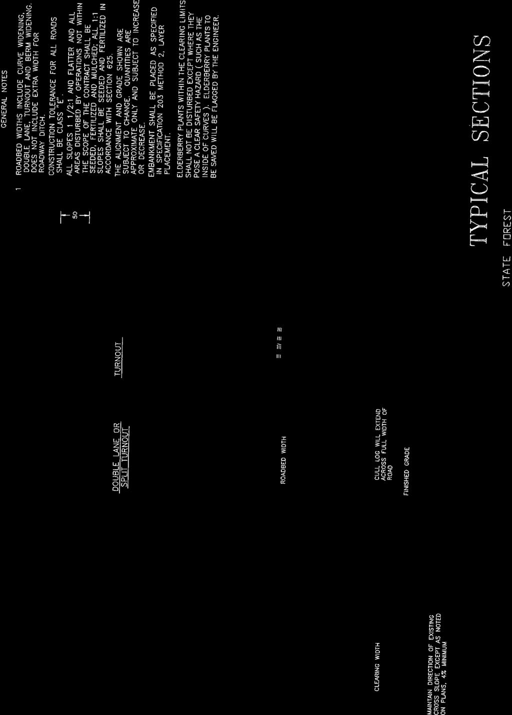
TRANSPORTATION SYSTEM MANAGEMENT PLAN
|
|
|
- Samson Lynch
- 6 years ago
- Views:
Transcription
1 Transportation System Management Plan FERC Project Nos. 2085, 2175, 67 and 120 TRANSPORTATION SYSTEM MANAGEMENT PLAN BIG CREEK HYDROELECTRIC SYSTEM MAMMOTH POOL BIG CREEK Nos. 1 AND 2 BIG CREEK Nos. 2A, 8, AND EASTWOOD BIG CREEK No. 3 FERC Project Nos. 2085, 2175, 67, and 120 FEBRUARY 2007 Copyright 2007 Southern California Edison Company February 2007
2 Transportation System Management Plan FERC Project Nos. 2085, 2175, 67 and 120 TABLE OF CONTENTS Page 1.0 OBJECTIVE DESCRIPTION OF PROJECT ACCESS TRANSPORTATION SYSTEM TRANSPORTATION SYSTEM MAINTENANCE ACTIVITIES San Joaquin River Trail Maintenance MEASURES TO MINIMIZE OR ELIMINATE POTENTIAL IMPACTS FROM ROAD MAINTENANCE ACTIVITIES Erosion Control Grading and Contouring Construction of Erosion Control Structures Slope Stabilization Revegetation Wind Erosion Historic Properties Management Plan Vegetation Management and Invasive/Noxious Weed Control ESAP Program REHABILITATION NEEDS Immediate Rehabilitation needs Future Projects Rehabilitation of Unneeded Roads ROAD ACCESS ROAD USE/TRAFFIC CONTROL MEASURES ANNUAL CONSULTATION REQUIREMENTS LITERATURE CITED...10 Copyright 2007 Southern California Edison Company i February 2007
3 Transportation System Management Plan FERC Project Nos. 2085, 2175, 67 and 120 List of Tables Table 1. Project Related Roads and Trails and SCE Maintenance Activities. List of Figures Figures 1a-1c. Project Related Roads and Trails (Including Detailed Sheets 1-5). List of Attachments Attachment A Sierra National Forest - Road Maintenance P-Specifications Copyright 2007 Southern California Edison Company ii February 2007
4 Transportation System Management Plan FERC Project Nos. 2085, 2175, 67 and OBJECTIVE This Transportation System Management Plan (Plan) has been developed for Southern California Edison's (SCE) Projects included in the Big Creek Alternative Licensing Process (ALP), located in the Upper San Joaquin River Watershed. The Big Creek ALP is comprised of four FERC licenses (Projects): Mammoth Pool (FERC No. 2085), Big Creek Nos. 1 and 2 (FERC No. 2175), Big Creek Nos. 2A, 8, and Eastwood (FERC No. 67), and Big Creek No. 3 (FERC No. 120). These Projects consist of seven powerhouses and four major reservoirs with a combined dependable operating capacity of approximately 890 megawatts (MW). The objective of the Plan is to address transportation system management issues in a comprehensive manner and to put all requirements for the above licenses in one plan that would cover Big Creek Hydro System Operations. The Plan will describe the transportation system used by SCE to access the ALP Project facilities. The Plan will address road and trail issues related to access, maintenance activities, rehabilitation needs, road use and traffic control measures. The Plan will describe measures that SCE will implement to repair, minimize, or eliminate impacts associated with the maintenance and operation of SCE s Big Creek ALP Hydroelectric Projects. This Plan only addresses Project Roads and Trails: (1) located within FERC Project boundaries; (2) used by SCE for the operation and maintenance of the Project: and (3) closed to public motor vehicle use. Table 1 provides a list of Project roads and trails that are addressed by this Plan. SCE s use of Sierra National Forest (SNF) open access public roads (non-project roads) is not addressed in this Plan. SCE s use of SNF public access roads will be addressed through a separate SNF Road Use Permit (RUP) in a manner consistent with other commercial uses of SNF roads. Minor changes in Project Boundaries may be required to ensure consistency with SCE s operations and maintenance use patterns. 2.0 DESCRIPTION OF PROJECT ACCESS TRANSPORTATION SYSTEM The transportation system in the Project vicinity includes one state route, county roads, open access roads on public lands, closed access roads on public lands, closed access roads on private lands, and foot trails. State route (SR) 168 is a two-lane highway that serves as a main access route into the Big Creek and Kaiser Basins from the Fresno metropolitan area. State route 168 provides access to the community of Shaver Lake and ends near the community of Lakeshore along the northeast shore of Huntington Lake. County roads in the Big Creek Basin considered primary access roads include: (1) Jose Basin Road (M2441 in Fresno County) and Italian Bar Road (M2080 in Fresno County and road 225 in Madera County) that provide access to the Big Creek No. 3 Project facilities; (2) Huntington Lake Road (FRE 2710 in Fresno County) that provides access from Shaver Lake to the community of Big Creek and continues to Huntington Lake; and (3) Huntington Lodge Road (FRE 3380) provides access to Dams 1 and 2 and other Project facilities south of Huntington Lake. Other access roads on public Copyright 2007 by Southern California Edison Company 1 February 2007
5 Transportation System Management Plan FERC Project Nos. 2085, 2175, 67 and 120 lands in the basin are United States Forest Service (USDA-FS) roads. Principal USDA- FS access roads are: (1) Kaiser Pass Road (NFSR 5S80) that provides access from Huntington Lake over Kaiser Pass into the upper basin area and ends near Thomas A. Edison Lake; (2) Florence Lake Road (NFSR 7S01) that provides access to Florence Lake from the Kaiser Pass Road; (3) Railroad Grade Road (NFSR 8S08) that leads from the community of Big Creek to the Jose Basin area; (4) Minarets Road (NFSR 4S81) that provides access to the Mammoth Pool Reservoir and Project facilities; (5) Mammoth Pool Road (NFSR 6S25) from Minarets Road to Mammoth Pool; and (6) Mammoth Pool Powerhouse Road (NFSR 8S03) that provides access from Minarets Road to the Mammoth Pool Powerhouse. These are routes used by SCE and by the public when traveling through or within the basin. In addition to these primary roads, there are numerous other roads throughout the Forest that are open to the public and provide access to campgrounds, Project facilities such as reservoirs, dispersed and developed recreation facilities, and areas of interest in the ALP Project vicinity. There are several roads within the basin that are closed to public motor vehicle access and are used almost exclusively by SCE to access ALP Project facilities. The Canyon Road (NFSR 8S05) is an SCE road that originates off of Huntington Lake Road near the community of Big Creek and ends near the Big Creek No. 3 Project facilities. The segment of the Mammoth Pool Powerhouse Road (NFSR 8S03) between Mammoth Pool Powerhouse and the Canyon Road (NFSR 8S05) is also an SCE road segment that is closed to public motor vehicle access. Both roads are integral components of the SCE transportation network that provide access to SCE hydroelectric Project facilities in the Big Creek canyon and the San Joaquin River canyon. SCE also uses a number of foot trails to access Project facilities (i.e., stream gages and small diversions). SCE will maintain roads and trails within the basin that are within license boundaries, closed to public motor vehicle use, and are used almost exclusively by SCE to access various Project facilities (Table 1). SCE will maintain roads and trails outside license boundaries where the primary purpose is to provide access for SCE to operate its facilities. These roads will be authorized by a Road Use Permit and SCE will be responsible for maintenance at a rate commensurate with SCE use. The USFS will calculate commensurate share responsibilities based on SCE access to SCE facilities. Estimates may be based on traffic surveillance, recreation use reports, or estimates derived through observation. SCE may perform maintenance of these roads and/or provide the Forest Service with deposits for maintenance activities at Forest Service discretion. The three roads most commonly used by SCE vehicles are Huntington Lake Road (FRE 2710), Canyon Road (NFSR 8S05), and Mammoth Pool Powerhouse Road (NFSR 8S03) between Mammoth Powerhouse and Big Creek Powerhouse No. 8. The majority of SCE vehicle trips originate from SCE s Northern Hydro facilities near the town of Big Creek. From this location Huntington Lake Road and Canyon Road are main routes to reach all the Project facilities in the basin. Other commonly used roads include Kaiser Pass Rd. (NFSR 5S80), Florence Lake Rd. (NFSR 7S01), Mammoth Pool Powerhouse 8 Rd. (NFSR 8S03) from Rd. 4S81 to PH 8, Minarets Rd (4S81), and Mammoth Pool Rd. (NFSR 6S25). The majority of SCE vehicles are trucks or pick-up trucks with four- Copyright 2007 Southern California Edison Company 2 February 2007
6 Transportation System Management Plan FERC Project Nos. 2085, 2175, 67 and 120 wheel drive. To a lesser extent sport utility vehicles with four-wheel drive are also used. Other SCE vehicles which require critical vehicle access include dump trucks to haul gravel or soil, flatbed and lowbed trucks to haul equipment, a grader, a loader, and a crane (SCE 2004). SCE uses this network of roads and trails to travel to their administrative offices and hydroelectric facilities to conduct routine operation and maintenance activities. However, travel in some areas of the basin is limited by restrictions imposed to reduce impacts to deer or T&E species, or by season when snowfall closes roads. For example, travel on the Mammoth Pool Road (NFSR 6S25) is restricted during deer migration season from May 1 to June 15 to reduce impacts to mule deer. Winter snowfall restricts vehicular access into the upper basin area east of Kaiser Pass and to Mammoth Pool Reservoir because the Kaiser Pass Road and Minarets Road over Mile High Vista are not normally plowed during the winter and were not designed for all weather use. These seasonal travel conditions influence SCE vehicle activity in these areas. Therefore, maintenance at facilities east of Kaiser Pass and Mammoth Pool Reservoir is concentrated during months when the roads are open, whereas maintenance at facilities that can be reached year-round tends to be distributed more evenly throughout the year. Roads and trails associated with each of the ALP Projects are presented in Table 1. Table 1 provides information on Project Roads and Trails including: road name; Sierra National Forest (SNF) transportation inventory road number; project related road length (in miles); and road surface type. These roads and trails are depicted on Figures 1a through 1c and detailed sheets 1through 5. SCE and USFS will review and revise Table 1 contents as the need arises. SCE and USFS will maintain a list of additions, deletions, and corrections to Table 1. A meeting will occur once every five years to revalidate the contents of Table 1, or when either party seeks review. Changes in Table 1 will occur with SCE and SNF concurrence, and will become guidance for this Plan. 3.0 TRANSPORTATION SYSTEM MAINTENANCE ACTIVITIES Routine road and trail maintenance activities that SCE conducts include grading or regraveling of unpaved dirt and gravel surfaces to ensure surface drainage is functioning properly, paving or patching of existing paved roads, cleaning of culverts and ditches, vegetation trimming and clearing along roads and trails, hazard tree removal, snow removal, and sanding. These activities are conducted on an as needed basis. Table 1 provides information on the type and frequency of maintenance activities SCE conducts on roads and trails. The frequency at which maintenance activities are conducted is identified in Table 1 as (1) annual (activity typically occurs once a year), (2) regular (activity will occur one or more times during a five-year period), or (3) infrequent (activity typically will occur during a 20-year period, but less than once every five years). Vegetation control by clearing or trimming along road and trail margins may be performed using hand tools or mechanical methods, and is typically conducted on a Copyright 2007 Southern California Edison Company 3 February 2007
7 Transportation System Management Plan FERC Project Nos. 2085, 2175, 67 and 120 regular schedule (one or more times during a five year period). Grading, drainage maintenance, and paving activities are typically conducted on an as needed basis, as outlined in Table 1. SCE also maintains signage, fencing, and gates. At locations where trails share their alignment with a Project road, the trails will be maintained to a road use standard, which will also accommodate use of the road by hikers and pack animals. SCE will perform, at its expense and using qualified personnel, periodic condition surveys of roads and trails to ensure that maintenance activities are being performed with adequate frequency. Condition surveys will identify necessary changes in frequency, methodology being used and deferred maintenance requirements in order to ensure minimal impacts to resources. Condition surveys will be coordinated with the USFS, and will not preclude separate condition surveys or inspections being conducted by the USFS. Initial condition surveys on all roads in Table 1 will be performed by SCE within 1 year of License and at 5 year intervals thereafter unless otherwise agreed to by USFS. 3.1 SAN JOAQUIN RIVER TRAIL MAINTENANCE Portions of the San Joaquin River Trail share an alignment with Project roads NFSR 9S42, 8S44, and 8S44Y along a section of the trail between Italian Bar Bridge at Redinger Reservoir and Mammoth Pool Powerhouse. These roads are used by SCE to provide access to the Mammoth Pool Powerhouse Transmission Line between Big Creek Powerhouse No. 3 and Mammoth Pool Powerhouse. The public uses portions of these roads when hiking the San Joaquin River Trail. The surface of these roads is graded natural, which is a graded dirt surface suitable for vehicle, hiker, and pack animal use. The graded natural road surface provides a footing surface for pack animal use. SCE will continue to maintain the graded natural road surface on portions of the road that have a shared trail alignment, and also at those locations where the San Joaquin River Trail crosses a Project Road. 4.0 MEASURES TO MINIMIZE OR ELIMINATE POTENTIAL IMPACTS FROM ROAD MAINTENANCE ACTIVITIES This section describes general measures that will be used, where applicable, for SCE maintained roads and trails to minimize potential impacts on the environment that may occur as the result of maintenance or improvements. These measures will incorporate applicable Best Management Practices (BMPs) for water quality management and will correspond with prescriptions identified in other Project resource management plans, as appropriate. If the need for road improvements other than routine maintenance activities occurs, then specific measures will be developed on a case-by-case basis to protect other resources that may be affected. Specific measures will depend on the site and physical conditions encountered. These measures are expected to include erosion and traffic control, cultural resource protection, and biological resource protection. In addition, these measures will incorporate, but are not limited to, applicable BMPs for Copyright 2007 Southern California Edison Company 4 February 2007
8 Transportation System Management Plan FERC Project Nos. 2085, 2175, 67 and 120 water quality management found in sections 12.2, 12.21, and of the field guide Water Quality Management for Forest System Lands in California. These measures comply with federal laws including, but not limited to, the National Environmental Policy Act (NEPA), Endangered Species Act (ESA), National Historic Preservation Act (NHPA), Clean Air Act (CAA), Clean Water Act (CWA), and the National Forest Management Act (NFMA). Measures that may be implemented by SCE and coordination activities with other resource management plans are summarized in the following sections. 4.1 EROSION CONTROL The following measures will be implemented in conjunction with road maintenance activities, where applicable. In addition, specific road maintenance direction is included in the SNF Road Maintenance P-Specifications in Attachment A GRADING AND CONTOURING Grading will conform to natural ground contours, where feasible. To the extent possible, efforts will be made to retain the original drainage patterns and not create patterns that will accelerate erosion. SCE will not sidecast materials. Disposal sites for excess material will be agreed upon in advance by SCE and USFS CONSTRUCTION OF EROSION CONTROL STRUCTURES In areas prone to significant flows and/or erosion, structures such as riprap, water bars, culverts, or small concrete retaining structures may be necessary. Where required, sedimentation basins (and/or sediment fences) may be used to control sediments where work is conducted in or adjacent to streams SLOPE STABILIZATION Certified weed free straw and/or jute matting will be used for slope stabilization where applicable. The matting would be placed on graded slopes and used to hold the slope prior to revegetation and after revegetation until plants have been established REVEGETATION Where applicable, revegetation may be used to control erosion and sedimentation on a long-term basis. Revegetation methods and plant palettes are site-specific and would require preparation of a revegetation plan to identify types of plants to be used and the appropriate method and time of planting. The revegetation plan would be prepared in consultation with the SNF at the time the maintenance work is performed WIND EROSION Long-term wind erosion can be reduced through revegetation or the intermittent use of dust-palliatives if revegetation is not an option. Lath fences or earthen berms may be used to reduce wind velocities in areas prone to wind erosion. Copyright 2007 Southern California Edison Company 5 February 2007
9 Transportation System Management Plan FERC Project Nos. 2085, 2175, 67 and HISTORIC PROPERTIES MANAGEMENT PLAN SCE maintains a Historic Properties Management Plan (HPMP) in consultation with the State Historic Preservation Officer (SHPO), SNF, and local Native American representatives to address potential Project effects on cultural resources. The HPMP describes procedures for regulatory consultation and treatment for archaeological properties during routine Project maintenance and operation related activities, and measures for unforeseen circumstances requiring prompt emergency response. Project related road use is addressed in the HPMP as follows: The operation of SCE vehicles and the movement of SCE heavy equipment across National Register of Historic Places Archaeological properties shall be avoided unless operation and movement occurs on an existing roadway or an emergency arises (see below); Reasonable effort shall be made to avoid road maintenance activities that may affect archaeological properties. Signage and protection requirements are described in the HPMP; Archaeological properties traversed by existing roads where SCE has maintenance responsibility shall be protected, and appropriate restrictions on use or maintenance shall be applied; If measures to protect archaeological properties fail under normal circumstances (i.e., routine operation and maintenance), SCE, in consultation with SHPO, Commission, and the SNF (for those properties on SNF lands), shall follow the provisions of 36 CFR Part ; Under extraordinary circumstances (i.e., unusual system outages caused by severe weather, flood, landslide, earthquake, or other natural cataclysm) where prompt restoration of electrical service is a vital necessity, reasonable effort shall be made to minimize effects on archaeological properties during emergency repair work. The provisions of 36 CFR Part shall be followed to determine appropriate additional treatment; and Previously undiscovered historic properties encountered during operation and maintenance of the ALP Projects shall be treated in accordance with the HPMP in consultation with SHPO, Commission, and the SNF (for properties on SNF lands). Under circumstances where those newly discovered resources cannot be preserved partially or wholly in place, they shall be evaluated in accordance with 36 CFR Part 60; and treatment shall be determined pursuant to 36 CFR Part Copyright 2007 Southern California Edison Company 6 February 2007
10 Transportation System Management Plan FERC Project Nos. 2085, 2175, 67 and VEGETATION MANAGEMENT AND INVASIVE/NOXIOUS WEED CONTROL Vegetation management and invasive/noxious weed control are described in the Vegetation and Noxious Weed Management Plan for the ALP Projects. This plan includes evaluation and implementation of maintenance activities related to vegetation, potential impacts, and mitigation measures, where necessary. Locations of vehicle cleaning sites are described in the Vegetation and Noxious Weed Management Plan. 4.4 ESAP PROGRAM The Endangered Species Alert Program (ESAP) was developed to provide SCE personnel with a means for identifying the potential occurrence of legally protected plant and animal species in the SCE Service Territory. For each sensitive species within the SCE Service Territory, the ESAP Manual includes a photograph, description, natural history information, and map showing the species distribution in relation to SCE s facilities. This manual and maps are reviewed prior to implementing any ground disturbing activities in the Project area. Should a proposed activity have a potential to conflict with a known sensitive species population, SCE Environmental Affairs staff is contacted to evaluate the situation and, if needed, coordinate the appropriate permits with the regulatory agencies. SCE s Northern Hydro Division will develop an additional section to supplement the existing ESAP Noxious Weeds and Forest Service Sensitive Species potentially occurring in the Project area. 5.0 REHABILITATION NEEDS SCE, in consultation with the SNF, has full responsibility and will take appropriate measures to rehabilitate unsafe conditions or resource damage on Project Roads and Trails as shown in Table 1. SCE and the SNF will identify and agree upon specific road rehabilitation projects (including activity types, scheduling, and protection of other key resources) during an annual coordination meeting and document them in the Annual Plan of Operation. Gates or other vehicle control measures may be installed, where necessary, to achieve resource protection or facility security. Maintenance or construction projects on roads other than Project Roads and Trails on lands administered by USFS are generally subject to authorization through a Special Use Permit or Road Use Permit issued by the SNF, and have their own set of conditions and schedules covering maintenance needs. 5.1 IMMEDIATE REHABILITATION NEEDS Four Project roads have been identified with as needing immediate rehabilitation to provide for public safety or resource protection. These are 1) 8S03 Mammoth Pool Powerhouse Road between 8S05 Canyon Road and 8S08A Access road to Powerhouse No. 8; 2) 8S05F Access road to Powerhouse No. 8 penstock from 8S05; 3) 8S05FB Access road to Powerhouse No. 8 penstock from 8S05; and 4) 8S08A Access road south from Railroad Grade to West Portal. The rehabilitation projects can be performed by SCE staff, through the use of private contractors, or by the USFS through collection agreements. SCE, or its designee, will be responsible for performing all Copyright 2007 Southern California Edison Company 7 February 2007
11 Transportation System Management Plan FERC Project Nos. 2085, 2175, 67 and 120 needed rehabilitation activities through the provision of necessary personnel, equipment, materials, and management. Rehabilitation projects will be designed and constructed after review of USDA-FS specifications and standards applicable at the time of construction. Plans and specifications for rehabilitation projects shall be submitted to the USFS for review and approval prior to commencement of work. 5.2 FUTURE PROJECTS During the life of the License, rehabilitation or major maintenance will be required on roads and trails as they reach their service life. SCE will, at that time, be responsible for rehabilitation and maintenance costs of Project roads and trails as condition surveys require. Projects may include but are not limited to reapplication of gravel surface, chip seals, and repaving. SCE agrees to become a cooperator as equal (50/50) partner with USFS on future Capital Investment Projects and on Forest Service Public Roads projects that affect access to SCE facilities. Project proposals and status will be discussed at annual coordination meetings between SCE and USFS. 5.1 REHABILITATION OF UNNEEDED ROADS There are existing roads in the project area which are no longer needed for SCE s operations and maintenance of facilities. Roads that were previously used by SCE but no longer serve their needs and are not needed by the USFS for its land management activities are candidates for decommissioning. SCE will be responsible for the decommissioning of these roads. This may be done by SCE or by the USFS through collection agreements. Roads to be decommissioned will be identified, and agreed upon, during annual coordination meetings. The USFS will be responsible for the design and strategy of decommissioning efforts. Environmental compliance and required permits will be the responsibility of SCE. 6.0 ROAD ACCESS SCE will allow the SNF unrestricted access and use of any road constructed within the Project area for all purposes deemed necessary or desirable in connection with the protection, administration, management, and utilization of Federal lands or resources. The SNF shall have the right to extend rights and privileges for use of the right of way and road thereon to States and local subdivisions thereof, as well as to other users, including members of the public. The Forest shall control such use so as not to unreasonably interfere with use of the road by the Licensee. Unless approved separately in a plan for a particular project, SCE shall drive or park all Project vehicles, including but not limited to administrative and transportation vehicles and construction and inspection equipment, on roads, turnouts or specifically designated areas. Copyright 2007 Southern California Edison Company 8 February 2007
12 Transportation System Management Plan FERC Project Nos. 2085, 2175, 67 and 120 SCE shall ensure that all SCE gates on Project related roads are maintained and signed according to SNF gate standards. These gates shall be constructed to allow SNF to install a USFS lock for SNF access or parking. SCE will ensure that authorized locks are kept in position so as to remain useful. A separate Road Use Permit or Special Use authorization shall be required of SCE for new construction or activities or when its activities fall outside normal and routine maintenance and operational needs. 7.0 ROAD USE/TRAFFIC CONTROL MEASURES SCE will install and maintain traffic controls to provide the public with adequate warning and protection from hazardous or potentially hazardous conditions associated with the Licensee s operations when conducting construction or maintenance activities adjacent to or on SNF roads that are open to public travel. Traffic control measures would be implemented on publicly accessed roads to support maintenance activities. These measures would be designed and coordinated in conjunction with the Fresno and/or Madera Sheriff Departments, the Fresno and/or Madera County Planning and/or Public Works Departments, and the SNF, as needed. SCE will consult with SNF regarding road sign repair and/or replacement needs on Project Roads and Trails identified in Table 1. Sign requirements will meet standards listed in the Manual on Uniform Traffic Control Devices of the U.S. Department of Transportation, Federal Highway Administration. 8.0 ANNUAL CONSULTATION REQUIREMENTS SCE shall consult with the SNF each year to identify specific road rehabilitation and maintenance projects and other activities that will be performed each forthcoming year. Planned road maintenance activities by SCE will be identified and documented in the Annual Plan of Operations submitted to the SNF for concurrence. The Plan of Operations will document specific maintenance activities, schedules, and measures required for BMPs and resource protection resources. The Annual Plan of Operations will also include the identification of key resources (e.g., cultural resources) that may be affected by the planned road maintenance activities. Maintenance activities will follow prescriptions and correspond with other resource management plans, as appropriate. If the need for road improvement other than routine maintenance activities occurs, then specific measures will be developed on a case-by-case basis to protect resources that may be affected. Specific measures will depend on the site and physical conditions encountered. These measures are expected to include erosion and traffic control, cultural resource protection, and biological resource protection. Measures that may be required to protect other environmental resources (e.g., air and water) will be developed in consultation with the SNF on an as-needed basis. Other applicable federal agencies (e.g., U.S. Fish and Wildlife Service) and state agencies (e.g., California Department of Fish and Game and SHPO) will be consulted when appropriate. SCE shall obtain all Copyright 2007 Southern California Edison Company 9 February 2007
13 Transportation System Management Plan FERC Project Nos. 2085, 2175, 67 and 120 applicable permits and environmental compliance required to implement maintenance or rehabilitation measures. 9.0 LITERATURE CITED Southern California Edison Final Technical Study Report Package for the Big Creek Hydroelectric System Alternative Licensing Process (ALP). In SCE s Amended Preliminary Draft Environmental Assessment (APDEA) for the Big Creek ALP (Mammoth Pool Project (FERC Project No. 2085), Big Creek Nos. 1 and 2 (FERC Project No. 2175), Big Creek Nos. 2A, 8 and Eastwood (FERC Project No. 67), and Big Creek No. 3 (FERC Project No. 120)). February 2007 (Volume 4, SD-D, Books and 23). Copyright 2007 Southern California Edison Company 10 February 2007
14 Transportation System Management Plan FERC Project Nos. 2085, 2175, 67 and 120 TABLE Copyright 2007 by Southern California Edison Company February 2007
15 Transportation System Management Plan FERC Project Nos. 2085, 2175, 67 and 120 Table 1. Project Roads and SCE Operation and Maintenance Activities. SCE Operation & Maintenance Activities Roads Repair/Clearing FERC Project No. SCE MAP No. USFS ROAD No. USFS Name Termini Maintenance Level Surface Length (miles) Legal Quad Name SCE Name Grading Gravel/Paving Snow Removal / Sanding Culverts/Ditches/Water Bars Signage Fencing Gates Mammoth Pool Project (FERC No. 2085) Roads S025G MAMMOTH POOL G SP 6S25 - BOT. OF DAM 3 AC 0.6 T7S-R24E C Mammoth Pool Fishwater Generator access road from 6S25, Mammoth Pool Road, to base of Mammoth Pool Dam S003B BC2-3 TRANS SOUTH 8S03 - BC2-3 TRANS 2 NATIVE 0.6 T8S-R24E C Access road from 8S03 to Mammoth Pool penstock S003C BC2-3 TRANS NORTH 8S03 - BC2-3 TRANS 2 NATIVE 1.0 T8S-R24E C Access road to Mammoth Pool Transmission Line from 8S S003CA BC2-3 TRANS NORTH A 8S03B - NORTH 2 NATIVE 0.2 T8S-R24E C 8S03CA, spur road to Mammoth Pool Transmission Line S003CB BC2-3 TRANS NORTH B 8S03B - NW 2 NATIVE 0.3 T8S-R24E C Access road to Mammoth Pool Transmission Line from 8S03C S003CC BC2-3 TRANS NORTH C 8S03CB - NW 2 NATIVE 0.2 T8S-R24E C Access road to Mammoth Pool Transmission Line from 8S03C S003D MAMMOTH SURGE 08S003-SOUTH 2 NATIVE 0.5 T8S-R24E C Access road from 8S03 to Mammoth Pool Powerhouse surge chamber S044 HOOKER COVE 4S81 - Southeast 2 NATIVE 5.8 T8S-R23E C 8S44, Mammoth Pool Transmission Line access road S044Y DEEP COVE 8S03-8S44 2 NATIVE 3.3 T8S-R24E C 8S44Y, Mammoth Pool Transmission Line access road from gate near 8S03 to 9S S044YA DEEP COVE 8S03-8S44 2 NATIVE 0.5 T8S-R24E C 8S44YA, Mammoth Pool Transmission Line access road S044YB DEEP COVE 2 NATIVE 0.5 T8S-R24E C 8S44YB, Mammoth Pool Transmission Line access road S042 TRANSMISSION NO.1 8S44 - MAD NATIVE 4.2 T9S-R24E C 9S42, Mammoth Pool Powerhouse Transmission Line access road from gate near County Road 225, Italian Bar Road, to 8S S042A TRANS NO.1 SPUR A 9S42 - END 2 NATIVE 0.2 T9S-R24E C Access road to Mammoth Pool Transmission Line from 9S S047B ROCK CREEK TUNNEL 7S47 - Tunnel Muck 2 NATIVE 0.1 9S47A Access road to Rock Creek Tunnel MUCK Muck Pile 2085/ S003(02) MAMMOTH POWER HSE S. J. River - 08S05 3 AC 1.4 T8S-R24E C 8S03 (from Powerhouse No. 8 to Mammoth Pool Powerhouse) S025(03) MAMMOTH POOL 7S20-END 3 NAT>AGG 1.3 T7S-R24E C 6S25, Mammoth Pool Road, from 7S20, Shake Flat Creek access, to end at east abutment S025DA MAMMOTH POOL C 6S25-BOAT LAUNCH 3 NATIVE 0.2 T7S-R24E C 6S25DA, spur to Windy Point Picnic Area SPUR from 6S25D Mammoth Pool Project (FERC No. 2085) I I R X* X R I R X R I R X R I R R I R R I R R I R R I R X* X R I R X* X R I R X* X R I R X* X R I R X* X R I R X* X R I R I I A R X* X* X I I I R I R Trail E16 Trail to San Joaquin River Gage above Shakeflat Creek 7S20-SJR gage NA NATIVE 0.6 T9S-R24E C Trail to San Joaquin River Gage above Shakeflat Creek I I Copyright 2007 by Southern California Edison Company 1-1 February 2007
16 Transportation System Management Plan FERC Project Nos. 2085, 2175, 67 and 120 Table 1. Project Roads and SCE Operation and Maintenance Activities. SCE Operation & Maintenance Activities Roads Repair/Clearing FERC Project No. SCE MAP No. USFS ROAD No. USFS Name Termini Maintenance Level Surface Length (miles) Legal Quad Name SCE Name Grading Gravel/Paving Snow Removal / Sanding Culverts/Ditches/Water Bars Signage Fencing Gates Big Creek No. 1 & 2 Project (FERC No. 2175) Roads S005(02) CANYON 8S05E - PH8 2 AC 3.0 T8S-R24E C 8S05, Canyon Road (from Huntington Lake Road to Powerhouse No. 2 and 8S05E) S005C POWERHOUSE 2 8S05-EAST 2 AC 0.7 T8S-R24E C Powerhouse No.2 access road from Canyon Road S005CA POWERHOUSE 2TRANS 8S05C-NORTH 2 AC 0.3 T8S-R24E C Access to Big Creek No. 2 switchyard I I A R X* X* X I I A R X* I I A R X* S005E LINE 8S05-WEST 2 NATIVE 0.3 T8S-R24E C Old housing road 1 adjacent to Powerhouse No. 2 from 8S05, Canyon Road I I S005EA SOUTH LINE 8S05E-MP NATIVE 0.2 T8S-R24E C Old housing road 3 adjacent to Powerhouse No. 2 from 8S05E I I S005EC PEN LINE 8S05E-WEST 2 NATIVE 0.3 T8S-R24E C Old housing road 2 adjacent to Powerhouse No. 2 from 8S05E I I 2175/ S008A AGUA 8S08-SOUTH 2 NATIVE 0.5 T8S-R24E C Access road south from Railroad Grade to West Portal R I R 2175/ S013(02) CAMP SIX GATE S05 2 NATIVE 0.7 T8S-R24E C 8S13 from gate to 8S05, the Canyon Road I I A R X* S013K CAMP SIX K 8S013 - NORTH 2 NATIVE 0.2 T8S-R24E C 8S13K Access road to Powerhouse No. 2 penstock I I I R X* S066(01) HUNTINGTON DAMS M FS BDY 2 NATIVE 0.5 T8S-R25E C 8S66, from west end of Dam 2 to 8S66A I I A R S066(02) HUNTINGTON DAMS PVT - 8S066A 2 NATIVE 1.0 T8S-R25E C 8S66 from gate to west end of Dam 2 I I A R S066A STREAM GAGE 8S066 - GAGING STATION 2 NATIVE 0.6 T8S-R25E C 8S66A, access road to gaging station on Big Creek below Huntington Lake I I A R S066B DAM SPUR 8S66-NORTHEAST 2 NATIVE 0.7 T8S-R25E C 8S66B from Dam 2 to end I I I R X* S066BA DAM SPUR A 8S066B-8S066BC 2 NATIVE 0.1 T8S-R25E C Short road between 8S66B and 8S66BC I I I R X* S066BC DAM SPUR C 8S066B-EAST 2 NATIVE 0.3 T8S-R25E C East end of Dam 1 to Dam 1 drainage gates I I A R S066C(02) Dam Spur C FS BDY - PVT 2 NATIVE 0.5 T8S R25E S C 8S66C on public lands from 8S301 to 8S66 east I I I R S066C(03) Dam Spur C PVT - FS BDY 2 NATIVE 0.5 T8S R25E S C 8S66C on public lands from 8S301 to 8S66 east I I I R S066C(04) Dam Spur C FS BDY - 8S066 2 NATIVE 0.5 T8S R25E S C 8S66C on SCE private lands from gate to 8S302 I I I R S066X HUNTINGTON LEVEE 8S066-8S066 2 NATIVE 0.4 T8S-R25E C Road over Dam 2 I I A R S082 BIG CREEK HD QTRS M2710-SOUTHWEST 3 AC 0.4 T8S-R25E C 8S082 access to Hydro offices at Big Creek I I A* R X* S082A BCH SPUR A 8S082-8S082 3 AC 0.3 T8S-R25E C 8S082A access to Hydro offices at Big Creek I I A* R X* S082AA BCH SPUR AA 08S082A - LOOP 3 AC 0.2 T8S-R25E C Access road to Warehouse I I A* R X* S082B(01) BCH SPUR B 8S082-GATE 3 AC 0.2 T8S-R25E C 8S082B access to Hydro offices at Big Creek I I A* R X* S082B(02) BCH SPUR B GATE-PO.HOUSE #1 3 AC 0.2 T8S-R25E C 8S082B access to Powerhouse No. 1 I I A* R X* S082BA BCH SPUR BA 8S02B - 8S82 3 AC 0.2 T8S-R25E C Upper access road to Wastewater treatment plant from 8S82B I I A* R X* Copyright 2007 by Southern California Edison Company 1-2 February 2007
17 Transportation System Management Plan FERC Project Nos. 2085, 2175, 67 and 120 Table 1. Project Roads and SCE Operation and Maintenance Activities. SCE Operation & Maintenance Activities Roads Repair/Clearing FERC Project No. SCE MAP No. USFS ROAD No. USFS Name Termini Maintenance Level Surface Length (miles) Legal Quad Name SCE Name Grading Gravel/Paving Snow Removal / Sanding Culverts/Ditches/Water Bars Signage Fencing Gates Big Creek No. 1 & 2 Project (FERC No. 2175) (continued) Roads (continued) S082BB BCH SPUR BB 8S02B - SOUTH 3 AC 0.2 T8S-R25E C Lower access road to Wastewater treatment plant from 8S82B I I A* R X* S082BC BCH SPUR BC 8S82B - 8S82 3 AC 0.3 T8S-R25E C Access road to Fish Farm upper gate I I A* R X* S082C BCH SPUR C 8S082-8S082A 3 AC 0.1 T8S-R25E C 8S082C access to Hydro offices at Big Creek I I A* R X* S082D BCH SPUR D 8S082-8S082A 3 AC 0.1 T8S-R25E C 8S082D access to Hydro offices at Big Creek I I A* R X* S082E BCH SPUR E M M AC 0.5 T8S-R25E C Upper access road to SCE company housing I I A* R X* S082EA BCH SPUR EA 8S82E - M AC 0.2 T8S-R25E C Lower access road to SCE company housing I I A* R X* S082F BCH SPUR F 8S82E - NE 3 AC 0.2 T8S-R25E C Access road to Domestic water treatment plant from FRE 2710 I I A* R X* S082J BCH SPUR J M SE 3 AC 0.2 T8S-R25E C Upper access road to Powerhouse No. 1 from FRE 2710 I I A* R X* S082X SCE RESIDENCES M2710-SOUTHWEST 3 AC 0.4 T8S-R25E C 8S082X access to Hydro offices at Big Creek I I A* R X* S083(02) SIPHON 8S66-8S83A 2 NATIVE 0.9 T8S-R25E C 8S83 from 8S66 to 8S83A I I R S083A SIPHON SPUR A 8S83-8S66 2 NATIVE 0.2 T8S-R25E C 8S83A, connector road between 8S66T and 8S83 I I S301 SUNSET POINT M DIST. LINE 2 NATIVE 0.6 T8S-R25E C 8S301 from gate with 8S66T to penstock surge pipes I I I R X S302 BC PENSTOCK GATE M GATEHOUSE 2 NATIVE 1.0 T8S-R25E C 8S302, access to Big Creek No inch HSE gatehouse I I I R X* S017 EASTWOOD LINE SR168 - SOUTH 2 NATIVE 0.2 T9S-R25E C 9S17 access road to Eastwood Transmission line from Hwy 168 I I I R X* Big Creek No. 1 & 2 Project (FERC No. 2175) (continued) Trail NA Trail to Scott Lake Domestic Diversion Big Creek No. 3 Project (FERC No. 120) M diversion NA NATIVE 0.4 T8S-R25E C Trail to Scott Lake Domestic Diversion Roads S005(03) CANYON PH8 - M AC 7.3 T8S-R24E C 8S05, Canyon Road (from junction with 8S03 to junction with Italian Bar Road) I I A R X* X* X S005A PENSTOCK 3 NORTH 8S05-NORTH 2 NATIVE 0.3 T9S-R24E C Access road to Powerhouse No. 3 penstocks and gate house downhill from 8S05, Canyon I I R Road S005B PENSTOCK 3 SOUTH 8S05-SOUTH 2 NATIVE 0.2 T9S-R24E C 8S05B Access road to Powerhouse No. 3 penstock from 8S05 Canyon Road R R S005G LOWER PENSTOCK 8S05-PENSTOCK 2 NATIVE 0.2 T9S-R24E C 8S05G Access road to Powerhouse No. 3 surge chamber uphill from 8S05 Canyon I I R Road S005T CANYON TAILING 8S005 - WEST 2 NATIVE 0.1 T9S-R24E C 8S05T Access to tailings R I R S005TA CANYON TAILING A 8S008 - WEST 2 NATIVE 0.1 T9S-R24E C 8S05TA Access to tailings R I R S020 BAR M2090-EAST 2 BIT 0.4 T9S-R24E C 9S20 Access to Carpenter shop I I X* X* X S020A BAR A 9S20 - SOUTH 2 NATIVE 0.1 T9S-R24E C 9S20A Access road to transmission line tower I I R X* X* X I I Copyright 2007 by Southern California Edison Company 1-3 February 2007
18 Transportation System Management Plan FERC Project Nos. 2085, 2175, 67 and 120 Table 1. Project Roads and SCE Operation and Maintenance Activities. SCE Operation & Maintenance Activities Roads Repair/Clearing FERC Project No. SCE MAP No. USFS ROAD No. USFS Name Big Creek No. 3 Project (FERC No. 120) (continued) Termini Maintenance Level Surface Length (miles) Legal Quad Name SCE Name Roads (continued) S020B BAR B 9S20 - NE 2 NATIVE 0.1 T9S-R24E C 9S20B Access road to transmission line tower S020C BAR C 9S20-9S20 2 BIT 0.1 T9S-R24E C 9S20C Connector road between 9S20 loop Grading Gravel/Paving Snow Removal / Sanding Culverts/Ditches/Water Bars I I R X* X* X R I R S020D BAR SPUR D 9S20-M NATIVE 0.1 T9S-R24E C 9S20D Access to Carpenter Shop R I R S020DA BAR SPUR DA M2090-9S20D 2 NATIVE 0.2 T9S-R24E C 9S20DA Access to Garage and shops R I R S020E BAR SPUR E 9S20 - yard 2 NATIVE 0.1 T9S-R24E C 9S20E Access to material yard R I R S020F SCHOOLHOUSE F 9S89 - SOUTH 2 NATIVE 0.1 T9S-R24E C 9S88F Connector road between 9S20 loop I I R S088 CHAWANAKEE RES M2090-SOUTH 2 BST 0.3 T9S-R24E C 9S88 from Italian Bar Road to old company housing I I R X* X* X S088A SCHOOL 9S88-9S88 2 NATIVE 0.1 T9S-R24E C 9S88A Access to old company housing R I R S088X SCHOOLHOUSE TANK 9S88-SOUTH 2 BIT 0.3 T9S-R24E C 9S88X Access road to Powerhouse No. 3 water tank and shop I I R X* X* X S088XA SCHOOLHOUSE TANK A 9S88X - WEST 2 NATIVE 0.4 T9S-R24E C 9S88XA Access road to old company housing from 9S88X R R X* X* S089 SCHOOLHOUSE M2090-NORTH 2 NATIVE 0.5 T9S-R24E C 9S89 Access road to Powerhouse No. 3 administrative bldg. from Italian Bar Road I I R X* X* X S089BA BAR BA 09S089B-SUB 2 NATIVE 0.2 T9S R24E S C 9S89BA Access road to Powerhouse No. 3 and switchyard I I R Big Creek No. 2A, 8, & Eastwood Project (FERC No. 67) Roads S080Z MONO TUNNEL 5S80-NORTH 2 NATIVE 0.4 T61/2S-R27E C Mono Creek Diversion access road I I S001B(02) FLORENCE PICNIC GATE-SOUTH 2 A/C 0.5 T7S-R27E C 7S01B Access road to Florence Work Camp I I R R X* X S001BA WORK CAMP LOOP 7S01B-SOUTHEAST 2 NATIVE 0.3 T8S-R27E C 7S01BA Florence Work Camp road from 7S01B I I R R X* X S370D JACKASS MEADOW 07S370-SOUTH TO DAM 2 NATIVE 0.2 T7S-R27E C 7S370D Access road to Florence Dam and SPUR D water storage tank from 7S370 R I R X S370F JACKASS MEADOW 07S370-DAM 2 NATIVE 0.2 T7S-R27E C 7S370F Access road to Florence Dam from SPUR F 7S370 I I S002(01) CAMP 72 SR168-PVT 2 NATIVE 1.7 T9S-R25E C 8S02 from Highway 168 to 8S02B S002(02) CAMP 72 PVT-ADIT 2 NATIVE 2.0 T9S-R25E C 8S02 from Highway 168 to 8S02B I* I* X S002B CAMP 72 SPUR B 08S002-GRAVEL PIT 2 NATIVE 0.1 T8S-R25E C 8S02B Access to Huntington-Pitman-Shaver (ADIT) tunnel adit I 2085/ S003(02) MAMMOTH POWER HSE S. J. River - 08S05 3 A/C 1.4 T8S-R24E C 8S03 (from 8S05, Canyon Road, to 8S03A, Powerhouse No. 8 access road) I I A R X* X* S003A POWERHOUSE 8 8S03-WEST 2 A/C 0.4 T8S-R24E C Access road to Powerhouse No. 8 from 8S03 I I A R X* X* S005(01) CANYON M2710-8S05E 2 A/C 10.0 T8S-R25E C 8S05, Canyon Road (from Powerhouse No. 2 and 8S05E to Powerhouse No. 8) I I A R X* X* X S005F PENSTOCK 8 8S05-WEST 2 NATIVE 0.8 T8S-R24E C 8S05F Access road to Powerhouse No. 8 penstock from 8S05 I I R S005FB UPPER PEN 8 8S05F-NORTH 2 NATIVE 0.4 T8S-R24E C 8S05FB Access road to Powerhouse No. 8 penstock from 8S05 I I R S005L CANYON SPUR L 8S005 - EAST 2 NATIVE 0.1 T8S-R24E C Road to communication line near Powerhouse No. 8 I I I Signage Fencing Gates Copyright 2007 by Southern California Edison Company 1-4 February 2007
19 Transportation System Management Plan FERC Project Nos. 2085, 2175, 67 and 120 Table 1. Project Roads and SCE Operation and Maintenance Activities. SCE Operation & Maintenance Activities Roads Repair/Clearing FERC Project No. SCE MAP No. USFS ROAD No. USFS Name Big Creek No. 2A, 8, & Eastwood Project (FERC No. 67) (continued) Termini Maintenance Level Surface Length (miles) Legal Roads (continued) 2175/ S008A AGUA 8S08-SOUTH 2 NATIVE 0.5 T8S-R24E C Access road south from Railroad Grade to West Portal R I R X 2175/ S013(02) CAMP SIX GATE S05 2 NATIVE 0.7 T8S-R24E C 8S13 from the gate to 8S05, Canyon Road I I A R X* X S047(02) BALSAM GATE - TRANSMISSION LINE 2 NATIVE 2.2 T9S-R25E C 8S47 Access road to Eastwood Powerstation Transmission Line tower - from gate to end R R Quad Name SCE Name Grading Gravel/Paving Snow Removal / Sanding Culverts/Ditches/Water Bars Signage Fencing Gates S083(01) SIPHON 08S083A - PENSTOCK 2 NATIVE 0.9 T8S-R25E C 8S83 from 8S83A to Huntington Shaver Siphon I I R S094 PITMAN DIVERSION SR168-WEST 2 NATIVE 0.4 T8S-R25E C Pitman Creek Diversion access road I* I* A* R* X S303 RANCHERIA OVERFLOW 5S080-CAMPGROUND 2 NATIVE 0.1 T8S-R26E C 8S303 Access road to Eastwood Overflow CG Campground I I R S003(01) DAWN PVT-SR168 2 NATIVE 0.1 T9S-R24E-S C 9S03 from 8S08 to FRE 2710 (non-project segment on SCE private lands) R I R S024 TUNNEL OUTLET SR168-SOUTHEAST 2 NATIVE 0.6 T9S-R25E-S C 9S24 from Hwy 168 to North Fork Stevenson Creek gate No. 2 (Tunnel No. 7 Outlet) I I A R X S032 ELY MOUNTAIN SR168 - TRANS LINE 2 NATIVE 1.5 T9S-R25E C 9S32 from gate near Highway 168 to EPH Transmission Line I I A R X S032A BALSAM MEADOW 9S32-BALSAM F.BAY 3 NATIVE 1.0 T9S-R25E C 9S32A, spur from 9S32 to east side of Balsam Forebay I I R R S032AB BALSAM SPUR AB 9S32A-WEST 3 NATIVE 0.2 T9S-R25E C 9S32AB, spur from 9S32A to Balsam Forebay I I R R S032C FOREBAY SPUR 9S32-NORTH 3 NATIVE 0.5 T9S-R25E C Road below Balsam Forebay Dam R R S032CA FOREBAY SPUR CA 9S32C - 9S32 2 NATIVE 0.3 T9S-R25E C 9S32CA Access road to Eastwood Powerstation Transmission Line tower R R S032CB FOREBAY SPUR CB 9S32CA - EAST 2 NATIVE 0.1 T9S-R25E C 9S32CB R R S032CC FOREBAY SPUR CC 9S32 - SOUTH 2 NATIVE 0.7 T9S-R25E C 9S32CC R R S032CD FOREBAY SPUR CD 9S32C - NORTH 2 NATIVE 0.6 T9S-R25E C 9S32CD R R S032CE FOREBAY SPUR CE 9S32C - SOUTH 2 NATIVE 0.2 T9S-R25E C 9S32CE R R S032CF FOREBAY SPUR CF 9S32C - NW 2 NATIVE 0.1 T9S-R25E C 9S32CF R R S058(01) PERIMETER HWY GATE 3 NATIVE 0.1 T9S-R24E C 9S58 from Shaver Marina to SCE gate (nonproject segment) I I A* R X* X* X S058(02) PERIMETER GATE(N)-GATE(STEV. CK) 3 NATIVE T9S-R24E C 9S58 from gate to North Fork Stevenson Gage I I A* R X* X* X S058K BALSAM PORTAL 09S058-END 2 NATIVE 0.1 T9S-R25E-S C Access road to Eastwood Power Tunnel ACCESS entrance I I A* R X* X* X S311(01) HAMILTON SR168 - FS BDY 2 NATIVE 0.6 T9S-R25E C 9S311 Access to Eastwood Powerstation Transmission Line tower R I R X S311(02) HAMILTON FS BDY - SOUTH 2 NATIVE 0.2 T9S-R25E C 9S311 Access to Eastwood Powerstation Transmission Line tower R I R S311A HAMILTON SPUR A 9S311 - EAST 2 NATIVE 0.1 T9S-R25E C 9S311A Access to Eastwood Powerstation Transmission Line tower R R S312 BALSAM PH SW. YD HWY END 2 NATIVE 0.2 T9S-R25E C 9S312 access to Eastwood Substation from Highway 168 I I A R X Copyright 2007 by Southern California Edison Company 1-5 February 2007
20 Transportation System Management Plan FERC Project Nos. 2085, 2175, 67 and 120 Table 1. Project Roads and SCE Operation and Maintenance Activities. SCE Operation & Maintenance Activities Roads Repair/Clearing FERC Project No. SCE MAP No. USFS ROAD No. USFS Name Big Creek No. 2A, 8, & Eastwood Project (FERC No. 67) (continued) Termini Maintenance Level Surface Length (miles) Legal Roads (continued) 67 2 N/A CAMP EDISON HWY 168-CAMP EDISON NA AC 3.5 T9S-R24E C Camp Edison Roads I I A R N/A SHAVER DAM NORTH HWY 168-DAM NA NATIVE 0.2 T9S-R24E C Access road to Shaver Dam north I A* R X* X* X N/A SHAVER DAM SOUTH HWY 168-DAM NA NATIVE 0.2 T9S-R24E C Access road to Shaver Dam south I A* R X* X* X Quad Name SCE Name Grading Gravel/Paving Snow Removal / Sanding Culverts/Ditches/Water Bars Signage Fencing Gates N/A EAGLE POINT DAY-USE 9S58 -EAGLE PT DAY-USE NA NATIVE 1.1 T9S-R24E C Access road to Eagle Point Boat Only Day Use Area from 9S N/A EASTWOOD TAILRACE 9S58-EASTWOOD NA NATIVE 0.1 T9S-R24E C Access road to Eastwood Tailrace TAILRACE N/A EASTWOOD 9S58-EASTWOOD NA AC 0.9 T9S-R24E C Access Tunnel to Eastwood Power Station POWERSTATION POWERSTATION TUNNEL TUNNEL Big Creek No. 2A, 8, & Eastwood Project (FERC No. 67) (continued) I I I I I I A* R X* X* X Trails NA Trails to North-South Slide 7S65 - diversion NA NATIVE 0.1 Trails to North-South Slide Creek Diversions Creek Diversions NA Trail to Pitman Creek 7S65 - diversion NA NATIVE 0.1 Trail to Pitman Creek Gage near Tamarack Gage near Tamarack Mountain (below shaft) Mountain (below shaft) R R NA Trail to Big Creek Gage 8S05 - gage NA NATIVE 0.1 Trail to Big Creek Gage below Dam 5 below Dam 5 R R NA Trail to Bolsillo Creek 5S80H - gage NA NATIVE 0.1 Trail to Bolsillo Creek Gage above Intake Gage above Intake R R NA Trail to Camp 62 Creek 5S80 - gage and diversion NA NATIVE 0.2 Trail to Camp 62 Creek Gage and Diversion Gage and Diversion Dam Dam R R NA Trail to South Fork San 7S65 - gage NA NATIVE 0.1 Trail to South Fork San Joaquin River Gage Joaquin River Gage downstream of Jackass Meadow downstream of Jackass I I Meadow NA Trail to Chinquapin Creek Gage and Diversion Dam 7S01 - gage and diversion NA NATIVE 0.7 Trail to Chinquapin Creek Gage and Diversion Dam R R E01 Trial to Bear Creek Gage upstream of Bear Forebay 6S83 - gage NA NATIVE 0.3 Trial to Bear Creek Gage upstream of Bear Forebay R R NA Trail to Tombstone Creek Diversion Access road - diversion NA NATIVE Trail to Tombstone Creek Diversion Copyright 2007 by Southern California Edison Company 1-6 February 2007
21 Transportation System Management Plan FERC Project Nos. 2085, 2175, 67 and 120 Table 1. Project Roads and SCE Operation and Maintenance Activities. SCE Operation & Maintenance Activities Roads Repair/Clearing FERC Project No. SCE MAP No. USFS ROAD No. USFS Name Termini Maintenance Level Surface Length (miles) Legal Quad Name SCE Name Grading Gravel/Paving Snow Removal / Sanding Culverts/Ditches/Water Bars Signage Fencing Gates Big Creek No. 2A, 8, & Eastwood Project (FERC No. 67) (continued) Trails (continued) NA Trail from Jackass Meadow Campground to Florence Dam outlet and Gage NA Trail to Crater Creek Diversion Ditch (off of the Dutch Lake Trail) NA Two trails to Stevenson Creek Gage below Shave Lake Dam 7S370 - outlet and gage NA NATIVE 0.1 Trail from Jackass Meadow Campground to Florence Dam outlet and Gage 7S01B - 27E05 NA NATIVE 0.9 Trail to Crater Creek Diversion Ditch (off of the Dutch Lake Trail) I I Hwy gage NA NATIVE 0.1 Two trails to Stevenson Creek Gage below Shave Lake Dam R R I I Key: X - Done A - Annual (activity typically occurs each year) R - Regular (activity will occur one or more times in a 5-year period) I - Infrequent (activity typically occurs during a 20-year period, but less than once every 5 years) * This activity occurs at less than 50% at this type of facility in the Big Creek Study Area (1) This road is also included in the FERC boundary of the Big Creek Nos. 1 and 2 Project (FERC Project No. 2175). Copyright 2007 by Southern California Edison Company 1-7 February 2007
22 Transportation System Management Plan FERC Project Nos. 2085, 2175, 67 and 120 FIGURES Copyright 2007 by Southern California Edison Company February 2007
23 Transportation System Management Plan FERC Project Nos. 2085, 2175, 67 and 120 Placeholder for Figures 1a-1c. Project Related Roads and Trails (Including Detailed Sheets 1-5) Non-Internet Public Information These Figures have been removed in accordance with the Commission regulations at 18 CFR Section These Figures are considered Non-Internet Public information and should not be posted on the Internet. This information is provided in Book 24 of the Application for New License and is identified as Non-Internet Public information. This information may be accessed from the FERC s Public Reference Room, but is not expected to be posted on the Commission s electronic library, except as an indexed item. Copyright 2007 by Southern California Edison Company February 2007
24 Transportation System Management Plan FERC Project Nos. 2085, 2175, 67 and 120 ATTACHMENT A Sierra National Forest Road Maintenance P-Specifications Copyright 2007 by Southern California Edison Company February 2007
25
26
27
28
29
30
31
32
33
34
35
36
37
38
39
40
41
42
43
44
45
46
47
48
DRAFT. Dorabelle Campground Rehabilitation
 DRAFT Dorabelle Campground Rehabilitation September 2012 1.1 REGIONAL SETTING AND PROJECT LOCATION The Dorabelle Campground is located on the western shore of Shaver Lake in Fresno County, California (Section
PacifiCorp North Umpqua Hydroelectric Project FERC Project No VOLUME 1 EXHIBITS
 PacifiCorp North Umpqua Hydroelectric Project FERC Project No. 1927 A VOLUME 1 EXHIBITS TMP and SA Implementation Summary B Settlement Agreement (Section 15) C D E F G H I J K L M N O P Q R S T U Rolling
DEVIL CANYON PROJECT RELICENSING FERC PROJECT NUMBER TRANSPORTATION SYSTEM MANAGEMENT PLAN November 2018
 DEVIL CANYON PROJECT RELICENSING FERC PROJECT NUMBER 14797 TRANSPORTATION SYSTEM MANAGEMENT PLAN November 2018 State of California California Natural Resources Agency DEPARTMENT OF WATER RESOURCES Hydropower
Rule Governing the Designation and Establishment of All-Terrain Vehicle Use Trails on State Land
 Rule Governing the Designation and Establishment of All-Terrain Vehicle Use Trails on State Land 1.0 Authority 1.1 This rule is promulgated pursuant to 23 V.S.A. 3506. Section 3506 (b)(4) states that an
Daisy Dean Trail 628/619 ATV Trail Construction
 Background and Purpose and Need The Daisy Dean ATV Trail Construction Project is located in the Little Belt Mountains, Musselshell Ranger District, Lewis and Clark National Forest approximately 32 miles
Cultural Resource Management Report Deer Valley 4wd Restoration and Blue Lakes Road Maintenance Project R
 Cultural Resource Management Report R2015-05-03-10005 Undertaking Description: The proposes to perform road maintenance and meadow restoration on the Deer Valley 4wd trail and road maintenance on the Blue
REC 22 WILDERNESS AREAS
 REC 22 WILDERNESS AREAS 1.0 EXECUTIVE SUMMARY This study focuses on recreational use associated with four designated Wilderness areas in the Southern California Edison (SCE) Big Creek Alternative Licensing
Bear Creek Habitat Improvement Project
 06/10/10 Bear Creek Habitat Improvement Project El Paso County, Colorado Pike National Forest and Colorado Springs Utilities Owned Land Report prepared by: Eric Billmeyer Executive Director Rocky Mountain
DECISION MEMO. Rawhide Trail #7073 Maintenance and Reconstruction
 Page 1 of 6 Background DECISION MEMO USDA Forest Service Jefferson Ranger District Jefferson County, Montana Rawhide Trail #7073 is located in the Elkhorn Mountain Range approximately 10 miles east of
REC 16 EMERGENCY SERVICES EVALUATION
 REC 16 EMERGENCY SERVICES EVALUATION 1.0 EXECUTIVE SUMMARY The emergency services evaluation study identifies and characterizes available emergency services and those emergency service providers that respond
2.0 Resource Management Goals of Agencies with Jurisdiction Over the Resource to be Studied
 Study 9.1 PRIMARY PROJECT ROADS AND TRAILS August 2011 1.0 Project Nexus Yuba County Water Agency s (YCWA or Licensee) continued use, operation and maintenance (O&M) of s (Project) Primary Project Roads
Decision Memo for Desolation Trail: Mill D to Desolation Lake Trail Relocation
 for Salt Lake County, Utah Uinta-Wasatch-Cache National Forest Salt Lake Ranger District 1. Background The present location of the Desolation Trail (#1159) between Mill D and Desolation Lake follows old
Section 61 Recreational Vehicle Park / Campground (Bylaw No. 2012/10)
") Part 7 General Regulations Section 61 Recreational Vehicle Park / Campground (Bylaw No. 2012/10) 61.1 A comprehensive site plan shall be provided to the satisfaction of the Development Authority that shows
Part 7 General Regulations Section 61 Recreational Vehicle Park / Campground (Bylaw No. 2012/10) 61.1 A comprehensive site plan shall be provided to the satisfaction of the Development Authority that shows
Existing Resource Information
 Botanical and Wildlife Vegetation alliances/wildlife habitats Grasslands annual/perennial Chaparral mixed/montane/chamise-redshank Riparian montane/valley foothill riparian Sierran mixed conifer Montane
ROAD AND TRAIL PROJECT APPROVAL
 ROAD AND TRAIL PROJECT APPROVAL www.marincountyparks.org Marin County Parks, 3501 Civic Center Dr, Suite 260, San Rafael, CA 94903 DATE: July 12, 2017 PRESERVE: Gary Giacomini Open Space Preserve PROJECT:
Appendix A Appendix A (Project Specifications) Auk Auk / Black Diamond (Trail 44) Reroute
 Auk Auk / Black Diamond (Trail 44) Reroute") Appendix A (Project Specifications) Auk Auk / Black Diamond (Trail 44) Reroute I. Proposed Action: This project proposes to reroute approximately 1,800 feet of a 50 inch wide trail, off of private property
Appendix A (Project Specifications) Auk Auk / Black Diamond (Trail 44) Reroute I. Proposed Action: This project proposes to reroute approximately 1,800 feet of a 50 inch wide trail, off of private property
CHAPTER III: TRAIL DESIGN STANDARDS, SPECIFICATIONS & PERMITS
 CHAPTER III Trail Design Standards, Specifications & Permits This chapter discusses trail standards, preferred surface types for different activities, permits, and other requirements one must consider
Description of the Proposed Action for the Big Creek / Yellow Pine Travel Plan (Snow-free Season) and Big Creek Ford Project
 and Big Creek Ford Project") Description of the Proposed Action for the Big Creek / Yellow Pine Travel Plan (Snow-free Season) and Big Creek Ford Project Payette National Forest Krassel Ranger District Valley and Idaho Counties, Idaho
Description of the Proposed Action for the Big Creek / Yellow Pine Travel Plan (Snow-free Season) and Big Creek Ford Project Payette National Forest Krassel Ranger District Valley and Idaho Counties, Idaho
Preferred Recreation Recommendations Stemilt-Squilchuck Recreation Plan March 2018
 Preferred Recreation Recommendations Stemilt-Squilchuck Recreation Plan March 2018 Below are the recommended recreation ideas and strategies that package together the various recreation concepts compiled
112th CONGRESS. 1st Session H. R. 113 IN THE HOUSE OF REPRESENTATIVES
 HR 113 IH 112th CONGRESS 1st Session H. R. 113 To provide for additions to the Cucamonga and Sheep Mountain Wilderness Areas in the Angeles and San Bernardino National Forests and the protection of existing
Wallowa Falls Hydroelectric Project FERC Project No. P-308 Proposed Study Plans - Recreation August 2011
 Wallowa Falls Hydroelectric Project FERC Project No. P-308 August 2011 Prepared by: PacifiCorp Energy Hydro Resources 825 NE Multnomah, Suite 1500 Portland, OR 97232 For Public Review Wallowa Falls Hydroelectric
APPENDIX F List of Commitments
 APPENDIX F List of Commitments s Table F.1 Standard Mitigation Measures Mitigation Measure MnDOT Specification Number Status Update Description Status Update Utilities Provide early notice to utility operators
Buffalo Pass Trails Project
 Buffalo Pass Trails Project Hahns Peak/Bears Ears Ranger District, Medicine Bow-Routt National Forests and Thunder Basin National Grassland Routt County, Colorado T6N 83W Sections 3-5, 8; T6N 84W Sections
Project Planning, Compliance, and Funding
 Project Planning, Compliance, and Funding The plans above offer high level guidance to ensure that the A.T. is managed effectively as a whole unit in a decentralized management structure. Cooperative management
K SIGNAGE & TRAFFIC CONTROL. Table of Contents
 Table of Contents K1. ACCOMMODATION OF TRAFFIC... 1 K2. MINIMUM CONSTRUCTION SIGNING... 1 K3. SUBDIVISION SIGNS... 2 K4. TRAFFIC CONTROL DEVICES... 2 K4.1 Traffic Signs Regulations... 2 K4.2 Materials...
White Mountain National Forest Saco Ranger District
 United States Department of Agriculture Forest Service White Mountain National Forest 33 Kancamagus Highway Conway, NH 03818 Comm: (603) 447-5448 TTY: (603) 447-3121 File Code: 1950 Date: February 26,
Final Environmental Impact Statement for the Merced Wild and Scenic River. Comprehensive Management Plan, Yosemite National Park, Madera and Mariposa
 This document is scheduled to be published in the Federal Register on 02/26/2014 and available online at http://federalregister.gov/a/2014-04061, and on FDsys.gov DEPARTMENT OF THE INTERIOR 4312-FF NATIONAL
Coronado National Forest Santa Catalina Ranger District
 United States Department of Agriculture Forest Service Coronado National Forest Santa Catalina Ranger District File Code: 1950 Date: October 14, 2015 Dear Interested Party: The Santa Catalina Ranger District
Decision Memo Sun Valley Super Enduro & Cross-Country Mountain Bike Race. Recreation Event
 Decision Memo 2015 Sun Valley Super Enduro & Cross-Country Mountain Bike Race Recreation Event USDA Forest Service Ketchum Ranger District, Sawtooth National Forest Blaine County, Idaho Background The
National Forests and Grasslands in Texas
 United States Department of Agriculture Forest Service National Forests and Grasslands in Texas Sam Houston NF 394 FM 1375 West New Waverly, Texas 77358 Phone 936-344-6205 Dear Friends, File Code: 1950
Proposed Action. Payette National Forest Over-Snow Grooming in Valley, Adams and Idaho Counties. United States Department of Agriculture
 United States Department of Agriculture Forest Service January 2012 Proposed Action Payette National Forest Over-Snow Grooming in Valley, Adams and Idaho Counties Payette National Forest Valley, Adams
Decision Memo Broken Wheel Ranch Equestrian Outfitter Special-Use Permit Proposed Action
 Decision Memo Broken Wheel Ranch Equestrian Outfitter Special-Use Permit USDA Forest Service Mississippi Bluffs Ranger District, Shawnee National Forest Jackson and Union Counties, Illinois Proposed Action
SUMMER VILLAGE OF SILVER SANDS. Municipal Development Plan
 SUMMER VILLAGE OF SILVER SANDS Municipal Development Plan Bylaw 253-2014 Adopted August 22, 2014 Summer Village of Silver Sands Municipal Development Plan Bylaw No. 253-2014 Page 2 1 INTRODUCTION 1.1 SETTING
As outlined in the Tatshenshini-Alsek Park Management Agreement, park management will:
 Management Strategy General Strategy The priority management focus for the park is to ensure that its internationally significant natural, cultural heritage and recreational values are protected and that
Bradley Brook Relocation Project. Scoping Notice. Saco Ranger District. United States Department of Agriculture Forest Service
 Bradley Brook Relocation Project United States Department of Agriculture Forest Service Scoping Notice White Mountain National Forest February 2011 For Information Contact: Jenny Burnett White Mountain
Non-motorized Trail Plan & Proposal. August 8, 2014
 Town of Star Valley Ranch, Wyoming and the Star Valley Ranch Association in partnership with the USDA Forest Service, Bridger-Teton National Forest, Greys River Ranger District Non-motorized Trail Plan
Rural Rustic Road Program
 Virginia Department of Transportation s Rural Rustic Road Program Prepared by the Local Assistance Division Virginia Department of Transportation 1401 East Broad Street Richmond, Virginia 23219 Michael
City of Durango 5.8 FUNDING TRAILS DEVELOPMENT
 5.8 FUNDING TRAILS DEVELOPMENT The City has been successful in establishing dedicated local funding sources as well as applying for grants to develop the City s trail system, having received nearly $2.4
United States Department of the Interior National Park Service. Boundary Expansion Listed in National Register January 11, 2017
 NPS Form 10900-a (Rev. 8/2002) OMB No. 10240018 United States Department of the Interior National Park Service Boundary Expansion Listed in National Register January 11, 2017 National Register of Historic
Wilderness Areas Designated by the White Pine County bill
 Wilderness Areas Designated by the White Pine County bill SEC. 321. SHORT TITLE. This subtitle may be cited as the `Pam White Wilderness Act of 2006'. SEC. 322. FINDINGS. Congress finds that-- The White
PURPOSE AND NEED. Introduction
 Public Scoping: Allocation of Recreation Capacity for Commercial Outfitter Guide Services on North Kruzof Island Trails (Kruzof Island Outfitter Guide) PURPOSE AND NEED Introduction The U.S. Department
BACKGROUND DECISION. Decision Memo Page 1 of 6
 DECISION MEMO DEVIL S ELBOW BY-PASS, BOUNDARY TRAIL NO.1 U.S. FOREST SERVICE T9N, R7E, SECTION 9 RANGE 5E COWLITZ COUNTY WA MOUNT ST. HELENS NATIONAL VOLCANIC MONUMENT, GIFFORD PINCHOT NATIONAL FOREST
Tahoe National Forest Over-Snow Vehicle Use Designation
 Tahoe National Forest Over-Snow Vehicle Use Designation USDA Forest Service Tahoe National Forest February 20, 2015 Introduction The Forest Service, U.S. Department of Agriculture will prepare an Environmental
Proposed Action Kaibab Campground Capital Improvement Project September 2008
 Background Kaibab Campground Capital Improvement Project September 2008 The Williams Ranger District of the Kaibab National Forest is proposing to improve the Kaibab Lake Campground. Kaibab Lake Campground
Sample Regulations for Water Aerodromes
 Sample Regulations for Water Aerodromes First Edition (unedited version) March 2015 Notice to users: This document is an unedited version which is made available to the public for convenience. Its content
Porter Fk. #1. All unauthorized items removed as per FS & Rec Res guidelines. Footbridge may be needed for wheel chair access and for safety
 APPENDIX D Lot Specific Permit Compliance & Forest Plan (FP) Requirements Porter Fork Recreation Residence Tract (Items noted were documented in compliance letter, 8/12/2005, sent to all Rec. Residence
RIM TRAIL EXTENSION PROJECT
 DECISION MEMO For RAINBOW RIM TRAIL EXTENSION PROJECT Located on National Forest System Lands USDA Forest Service, Southwest Region Kaibab National Forest - North Kaibab Ranger District T.35 N, R.1 E,
RUSHMORE CONNECTOR TRAIL PROPOSAL
 PURPOSE AND NEED Background The U.S. Forest Service, Black Hills National Forest (Forest Service) has received a special use permit application from the State of South Dakota Department of Game, Fish and
Understanding the caring capacity of the visitor experience Provide facilities to support a high level user experience Address visual quality through
 Understanding the caring capacity of the visitor experience Provide facilities to support a high level user experience Address visual quality through recreation ecological restoration opportunities Collaboration
Continental Divide National Scenic Trail Legislative History and Planning Guidance
 Continental Divide National Scenic Trail Legislative History and Planning Guidance Legislation, Policy, and Direction Regarding National Scenic Trails The National Trails System Act, P.L. 90-543, was passed
Kelly Motorized Trails Project Proposed Action
 Kelly Motorized Trails Project Proposed Action November 28, 2011 The Flagstaff Ranger District of the Coconino National Forest is seeking public input on the proposed Kelly Motorized Trails Project (formerly
WHEREAS, the City operates and manages Rapid City Regional Airport (RAP); and
; and") MEMORANDUM OF UNDERSTANDING BETWEEN THE RAPID CITY DEPARTMENT OF FIRE & EMERGENCY SERVICES AND RAPID CITY REGIONAL AIRPORT BOARD RELATING TO THE PROVISION OF AIRPORT RESCUE AND FIREFIGHTING SERVICES This
MEMORANDUM OF UNDERSTANDING BETWEEN THE RAPID CITY DEPARTMENT OF FIRE & EMERGENCY SERVICES AND RAPID CITY REGIONAL AIRPORT BOARD RELATING TO THE PROVISION OF AIRPORT RESCUE AND FIREFIGHTING SERVICES This
Sawtooth National Forest Fairfield Ranger District
 United States Department of Agriculture Forest Service Sawtooth National Forest Fairfield Ranger District P.O. Box 189 Fairfield, ID. 83327 208-764-3202 Fax: 208-764-3211 File Code: 1950/7700 Date: December
Appendix 1: Best Management Practices For Hang Gliding and Paragliding in Jasper National Parks
 Appendix 1: Best Management Practices For Hang Gliding and Paragliding in Jasper National Parks Name of Best Management Practice Best Management Practices for Hang Gliding and Paragliding in Jasper National
Decision Memo Ice Age Trail Improvement (CRAC 37)
") Decision Memo Ice Age Trail Improvement (CRAC 37) U.S. Forest Service Chequamegon-Nicolet National Forest, Medford-Park Falls Ranger District Taylor County, Wisconsin T32N, R2W, Town of Grover, Section
Decision Memo Ice Age Trail Improvement (CRAC 37) U.S. Forest Service Chequamegon-Nicolet National Forest, Medford-Park Falls Ranger District Taylor County, Wisconsin T32N, R2W, Town of Grover, Section
Silver Creek Plunge Campground Reconstruction
 Silver Creek Plunge Campground Reconstruction PROPOSED ACTION REPORT Emmett Ranger District Boise National Forest 1805 Highway 16, Room 5 Emmett, Idaho 83617 November 2009 Silver Creek Plunge Campground
Business Item No XXX. Proposed Action That the Metropolitan Council approve the Coon Creek Regional Trail Master Plan.
 Business Item No. 2015-XXX Metropolitan Parks and Open Space Commission Meeting date: July 7, 2015 For the Community Development Committee meeting of July 20, 2015 For the Metropolitan Council meeting
APPENDIX I STANDARD CONSULTATION PROTOCOL FOR TRAVEL MANAGEMENT ROUTE DESIGNATION
 APPENDIX I STANDARD CONSULTATION PROTOCOL FOR TRAVEL MANAGEMENT ROUTE DESIGNATION Developed Pursuant to Stipulation IV.A. of the Region 3 First Amended Programmatic Agreement Regarding Historic Property
Plans and Design Calculations for the Alder Creek Diversion Fish Screen
 TECHNICAL MEMORANDUM Plans and Design Calculations for the Alder Creek Diversion Fish Screen El Dorado Irrigation District 2890 Mosquito Road Placerville, CA 95667 Alder Creek Diversion Fish Screen Plans
Prior to contacting the Whitecourt Trailblazers Snowmobile Club, applicants must:
 WHITECOURT TRAILBLAZERS Box 607 Whitecourt, AB T7S 1N7 www.whitecourttrailblazers.ca CNT AMENDMENT Restriction Code 710: See Comments Comments All applicants are required to contact: Whitecourt Trailblazers
Trail Assessment Report
 Trail Assessment Report Trail Options for the Bear Creek Canyon located in Pikes Peak Ranger District, Pike National Forest and on Colorado Springs Utility Lands Due to the presence of a unique species
Appalachian Power Company Smith Mountain Hydroelectric Project FERC No Debris Management Plan
 Appalachian Power Company Smith Mountain Hydroelectric Project FERC No. 2210 Debris Management Plan Final July2008 TABLE OF CONTENTS Description Page SUMMARY 1 1.0 Introduction.. 2 1.1 Project Lands and
General Rules for Use of Lands Managed by the. Middle Peninsula Chesapeake Bay Public Access Authority
 General Rules for Use of Lands Managed by the Middle Peninsula Chesapeake Bay Public Access Authority As a visitor to lands managed by the Middle Peninsula Chesapeake Bay Public Access Authority (PAA),
ES Aircraft Deicing Document Identification Number Date: March 15, ) Activity Description:
 Activity Description:") ES-301-1.06 Aircraft Deicing Document Identification Number ES-301-1.06 Date: March 15, 2018 Document Owner: Keith Pass 1) Activity Description: Aircraft deicing is the application of aircraft deicing
ES-301-1.06 Aircraft Deicing Document Identification Number ES-301-1.06 Date: March 15, 2018 Document Owner: Keith Pass 1) Activity Description: Aircraft deicing is the application of aircraft deicing
Virginia Department of Transportation s Rural Rustic Road Program
 Virginia Department of Transportation s Rural Rustic Road Program Prepared by the Local Assistance Division Virginia Department of Transportation 1401 East Broad Street Richmond, Virginia 23219 Michael
White Mountain National Forest
 White Mountain National Forest United States Department of Agriculture Forest Service Eastern Region Boles Brook Snowmobile Bridge Decision Memo Boles Brook Snowmobile Bridge Project Town of Woodstock
Guide to the L. F. Manis Photographs
 This finding aid was produced using ArchivesSpace on February 29, 2016. English 2016 The Regents of the University of Nevada. All rights reserved. University of Nevada, Las Vegas. University Libraries.
DECISION MEMO North Zone (Legacy Trails) Trail Stabilization Project
 Trail Stabilization Project") DECISION MEMO North Zone (Legacy Trails) Trail Stabilization Project USDA FOREST SERVICE Rocky Mountain Region (R2) Shoshone National Forest Wapiti and Greybull Ranger District Park County, Wyoming Background
DECISION MEMO North Zone (Legacy Trails) Trail Stabilization Project USDA FOREST SERVICE Rocky Mountain Region (R2) Shoshone National Forest Wapiti and Greybull Ranger District Park County, Wyoming Background
SECTION 3 GENERAL DESCRIPTION OF THE RIVER BASIN
 SECTION 3 GENERAL DESCRIPTION OF THE RIVER BASIN SECTION 3 GENERAL DESCRIPTION OF THE RIVER BASIN River basin description. A general description of the river basin or subbasin, as appropriate, in which
This section evaluates the projected traffic operations and circulation impacts associated with the proposed upgrade and expansion of the LWRP.
 4.5 TRAFFIC AND CIRCULATION This section evaluates the projected traffic operations and circulation impacts associated with the proposed upgrade and expansion of the LWRP. 4.5.1 Environmental Setting Existing
Public Notice ISSUED: December 10, 2018 EXPIRES: January 9, 2019
 APPLICANT: REFER TO: St. Louis and Lake Counties Regional Rail Authority 2018-01942-ARC Public Notice ISSUED: December 10, 2018 EXPIRES: January 9, 2019 SECTION:404 - Clean Water Act 1. APPLICATION FOR
Amended Application for New License Major Project Existing Dam
 Amended Application for New License Major Project Existing Dam Exhibit A Project Description Security Level: Public Prepared by: Yuba County Water Agency 1220 F Street Marysville, CA 95901 www.ycwa.com
COMMISSION OF THE EUROPEAN COMMUNITIES. Draft. COMMISSION REGULATION (EU) No /2010
 No /2010") COMMISSION OF THE EUROPEAN COMMUNITIES Brussels, XXX Draft COMMISSION REGULATION (EU) No /2010 of [ ] on safety oversight in air traffic management and air navigation services (Text with EEA relevance)
COMMISSION OF THE EUROPEAN COMMUNITIES Brussels, XXX Draft COMMISSION REGULATION (EU) No /2010 of [ ] on safety oversight in air traffic management and air navigation services (Text with EEA relevance)
ENLOE HYDROELECTRIC PROJECT FERC PROJECT NO PUBLIC SAFETY PLAN. Final
 ENLOE HYDROELECTRIC PROJECT FERC PROJECT NO. 12569 PUBLIC SAFETY PLAN Final November 18, 2013 Okanogan Public Utility District 1331 2nd Ave N PO Box 912 Okanogan, WA 98840 ENLOE HYDROELECTRIC PROJECT FERC
Trails Technical Committee
 Trails Technical Committee Winter 2017 Draft Report Alignment Proposals for the Inyo National Forest and the Town of Mammoth Lakes Map ID #S18 February 08, 2017 Map ID #S18 Key Agreements As of February
Northern Rail Extension, Phase One
 General Project and Funding 1. Where does Phase One start? The rail line for Phase One begins roughly at the northern boundary of the former Bradbury property, but also includes work along Tom Bear Trail
S Central Coast Heritage Protection Act APRIL 21, 2016
 STATEMENT OF GLENN CASAMASSA ASSOCIATE DEPUTY CHIEF, NATIONAL FOREST SYSTEM U.S. FOREST SERVICE U.S. DEPARTMENT OF AGRICULTURE BEFORE THE UNITED STATES SENATE COMMITTEE ON ENERGY AND NATURAL RESOURCES
DRAFT GENERAL IMPLEMENTATION PLAN AND SPECIFIC IMPLEMENTATION PLAN MIDDLETON MUNICIPAL AIRPORT MOREY FIELD. Revised 12/12/03
 DRAFT GENERAL IMPLEMENTATION PLAN AND SPECIFIC IMPLEMENTATION PLAN MIDDLETON MUNICIPAL AIRPORT MOREY FIELD Revised 12/12/03 As recommended for approval by the Plan Commission General Project Description
Susitna-Watana Hydroelectric Project (FERC No ) Recreation Resources Study Study Plan Section Study Implementation Report
 Recreation Resources Study Study Plan Section Study Implementation Report") (FERC No. 14241) Recreation Resources Study Study Plan Section 12.5 2014 Study Implementation Report Prepared for Prepared by AECOM November 2015 TABLE OF CONTENTS 1. Introduction... 4 2. Study Objectives...
(FERC No. 14241) Recreation Resources Study Study Plan Section 12.5 2014 Study Implementation Report Prepared for Prepared by AECOM November 2015 TABLE OF CONTENTS 1. Introduction... 4 2. Study Objectives...
Guide to the L. F. Manis Photographs
 This finding aid was created by Lindsay Oden on February 27, 2018. Persistent URL for this finding aid: http://n2t.net/ark:/62930/f1vk60 2018 The Regents of the University of Nevada. All rights reserved.
Theme: Predominately natural/natural appearing; rustic improvements to protect resources. Size*: 2,500 + acres Infrastructure**:
 Recreation Opportunity Spectrum (ROS) Classes The Recreation Opportunity Spectrum (ROS) provides a way to describe the variations in the degree of isolation from the sounds and influences of people, and
Calgary River Access Strategy Priority Sites and Proposed Funding
 Calgary River Access Strategy Priority Sites and Proposed Funding CPS2017-0103 ATTACHMENT 2 A total of $7,660,000 (Class 5 estimate) is required to implement all sites within the Calgary River Access Strategy;
Virginia Department of Transportation Rural Rustic Road Program Manual
 Virginia Department of Transportation Rural Rustic Road Program Manual Administered by the Virginia Department of Transportation Local Assistance Division 2014 For further information, contact your local
COMMISSION IMPLEMENTING REGULATION (EU)
") 18.10.2011 Official Journal of the European Union L 271/15 COMMISSION IMPLEMENTING REGULATION (EU) No 1034/2011 of 17 October 2011 on safety oversight in air traffic management and air navigation services
18.10.2011 Official Journal of the European Union L 271/15 COMMISSION IMPLEMENTING REGULATION (EU) No 1034/2011 of 17 October 2011 on safety oversight in air traffic management and air navigation services
Proposal to Redevelop Lower Kananaskis River-Barrier Lake. Bow Valley Provincial Park
 Frequently Asked Questions Proposal to Redevelop Lower Kananaskis River-Barrier Lake Bow Valley Provincial Park Frequently Asked Questions What has been decided? What are the details of the plan? What
Sandbag Barrier. Suitable Applications Sandbag barriers may be suitable: As a linear sediment control measure:
 Categories EC Erosion Control SE Sediment Control TC Tracking Control WE Wind Erosion Control Non-Stormwater NS Management Control Waste Management and WM Materials Pollution Control Legend: Primary Category
MONTEREY REGIONAL AIRPORT MASTER PLAN TOPICAL QUESTIONS FROM THE PLANNING ADVISORY COMMITTEE AND TOPICAL RESPONSES
 MONTEREY REGIONAL AIRPORT MASTER PLAN TOPICAL QUESTIONS FROM THE PLANNING ADVISORY COMMITTEE AND TOPICAL RESPONSES Recurring topics emerged in some of the comments and questions raised by members of the
USDA Forest Service Deschutes National Forest DECISION MEMO. Round Lake Christian Camp Master Plan for Reconstruction and New Facilities
 USDA Forest Service Deschutes National Forest DECISION MEMO Round Lake Christian Camp Master Plan for Reconstruction and New Facilities Jefferson County, Oregon T. 13 S., R. 8 E., Section 16, W.M. Background:
RECREATIONAL VEHICLE RESORT DISTRICT R-RVR. Lacombe County Land Use Bylaw No: 1237/17 Date Adopted: July 6, Page 111
 RECREATIONAL VEHICLE RESORT DISTRICT Page 111 7.10 RECREATIONAL VEHICLE RESORT DISTRICT () 1 PURPOSE 2 USES The purpose of the Recreational Vehicle Resort District is to provide an area that will facilitate
KP Lasnaya 1 River
 KP 370.2 Lasnaya 1 River The Lasnaya 1 River crossing is protected by Reno mattings and a gabion wall on the north bank (Photo 1). The south bank consists of natural river gravel deposits on top of Reno
Section 106 Update Memo #1 Attachment D. Traffic Diversion & APE Expansion Methodology & Maps
 Section 106 Update Memo #1 Attachment D Traffic Diversion & APE Expansion Methodology & Maps I-65/I-70 North Split Interchange Reconstruction Project (Des. Nos. 1592385 & 1600808) Traffic Diversion and
Proposal to Redevelop Lower Kananaskis River-Barrier Lake. Bow Valley Provincial Park. Frequently Asked Questions
 Proposal to Redevelop Lower Kananaskis River-Barrier Lake Bow Valley Provincial Park Frequently Asked Questions What is being proposed? What are the details of the proposal? Where is the project area located?
b. Minimum Site Area. Recreational vehicle parks shall be located on a parcel of land not less than 3 acres in area.
 6450 RECREATIONAL VEHICLE PARK REGULATIONS 6450 TITLE AND PURPOSE. The provisions of Section 6450 through 6499, inclusive, shall be known as the Recreational Vehicle Park Regulations. The purpose of these
INTRODUCTION. Mailing address: Burke County Community Development Attn: Tim Johnson P. O. Box 219 Morganton, NC
 REQUEST FOR QUALIFICATIONS: PROFESSIONAL, EXPERIENCED TRAIL BUILDERS FOR THE CONSTRUCTION OF THE FONTA FLORA STATE TRAIL LAKE JAMES SECTION BURKE COUNTY COMMUNITY DEVELOPMENT INTRODUCTION Burke County
GATEWAY PHASE 2. U.S. Forest Service and the Mount Shasta Trails Association
 GATEWAY PHASE 2 U.S. Forest Service and the Mount Shasta Trails Association PROJECT DEVELOPMENT Brief history - Gateway Phase 1 - IMBA conceptual plan - BikeShasta: concert series - USFS & MSTA partnered
RULES OF TENNESSEE DEPARTMENT OF TRANSPORTATION AERONAUTICS DIVISION CHAPTER LICENSING AND REGISTRATION OF AIRPORTS TABLE OF CONTENTS
 RULES OF TENNESSEE DEPARTMENT OF TRANSPORTATION AERONAUTICS DIVISION CHAPTER 1680-1-2 LICENSING AND REGISTRATION OF AIRPORTS TABLE OF CONTENTS 1680-1-2-.01 Purpose 1680-1-2-.06 Repealed 1680-1-2-.02 Definitions
For Airport Environmental Services. Date Released: August 27, 2018 Deadline for Submission: 5:00pm, September 17, 2018
 COUNTY OF INYO REQUEST FOR QUALIFICATIONS For Airport Environmental Services Date Released: August 27, 2018 Deadline for Submission: 5:00pm, September 17, 2018 County of Inyo Public Works Department P.O.
1803 West Hwy 160 Monte Vista, CO (719) TTY (719)
 TTY (719)") USDA Forest Service Rio Grande National Forest http://www.fs.fed.us/r2/riogrande 1803 West Hwy 160 Monte Vista, CO 81144 (719)852-5941 TTY (719)852-6271 USDI Bureau of Land Management San Luis Valley Center
USDA Forest Service Rio Grande National Forest http://www.fs.fed.us/r2/riogrande 1803 West Hwy 160 Monte Vista, CO 81144 (719)852-5941 TTY (719)852-6271 USDI Bureau of Land Management San Luis Valley Center
Finn Creek Park. Management Direction Statement Amendment
 Finn Creek Park Management Direction Statement Amendment November 2013 Management Direction Statement Amendment Approved by: Jeff Leahy Regional Director, Thompson Cariboo BC Parks November 12, 2013 Date
Yard Creek Provincial Park. Management Plan
 Yard Creek Provincial Park Management Plan Draft January 2010 Yard Creek Provincial Park Management Plan Approved by: telàlsemkin/siyam/chief Scott Benton Bill Williams Squamish Executive Director ation