Comprehensive Recreation Trails Plan and High Conservation Value Forest Assessment
|
|
|
- Wilfrid Edmund McDaniel
- 6 years ago
- Views:
Transcription
1 Crow Wing County Land Services Department Comprehensive Recreation Trails Plan and High Conservation Value Forest Assessment Year One Outcomes & Recommendations 24 February 2011 version (Updated Following the Public Review)
2 Special Thanks to: Members of the Advisory Group Alan Steiff Bill Keefe Robert Manning Brett Hardy Gail Brecht Kathy Bernier Larry Moses Mary Claire Ryan Paul Thiede Rosemary Franzen Russell Heittola Shawn Roberts Tom Whitehead Staff of Crow Wing County and the Land Services Department Mark Liedl, Land Services Director Kirk Titus, Land Services Supervisor Bryan Pike, Natural Resource Manager Heather Becker, Technical/Administrative Specialist Jacob Frie, Natural Resource Manager Ryan Simonson, Natural Resource Manager Vickie Sullivan, Technical/Administrative Specialist Timothy Houle, County Administrator Crow Wing County Board Members District 1 Philip J. Trusty District 2 Paul M. Thiede District 3 Rachel Reabe Nystrom District 4 Rosemary Franzen District 5 Doug Houge Prepared with Assistance from Dovetail Partners 528 Hennepin Ave, Suite Minneapolis, MN ; info@dovetailinc.org 2
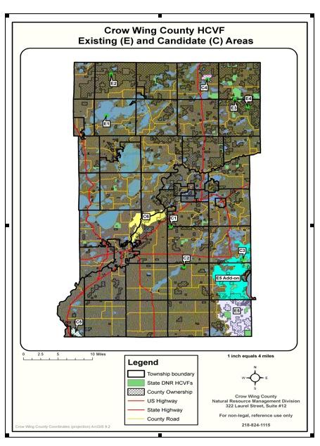
3 Table of Contents "#$%&'(#)%"************************************************************************************************************************************************ +,$%(-..********************************************************************************************************************************************************** / "#****************************************************************************************************************************** /,9:"")";2<-(%88-"&:#)%". ***************************************************************************************************************=> <-(%88-"&:#)%".2?%$2@A-()?)(26%$8.2%?2<-($-:#)%"20$:)9. *****************************************************=> B%"CD%#%$)E-&2@'88-$20$:)9. ********************************************************************************************************************* => "#$%#&'()*$(+$(#(&, / B%"CD%#%$)E-&2F)"#-$20$:)9. ************************************************************************************************************************ =G "#$%#&'()*$(+$(#(&, D%#%$)E-&2@'88-$20$:)9.******************************************************************************************************************************* =G "#$%#&'()*$(+$(#(&, D%#%$)E-&2F)"#-$20$:)9.********************************************************************************************************************************** =+ "#$%#&'()*$(+$(#(&, F:#-$20$:)9.********************************************************************************************************************************************************* =+ "#$%#&'()*$(+$(#(&, D:H%$2<-(%88-"&:#)%". *********************************************************************************************************************=I <-J)-K2#1-20$:)92,9:"")";2,$%(-.. ************************************************************************************************************** =I &-"#)?L2M-"(18:$N)";2D-#$)(.2?%$2<-($-:#)%"20$:)9.************************************************************************** =I O-J-9%A2:2O-().)%"2D:N)";2D:#$)P2?%$20$:)92,9:"")"; ************************************************************************** =Q2 SPA9%$-2,%#-"#):920$:)92T)"N:;-.2#1:#24:"2S"1:"(-2<-($-:#)%"2UAA%$#'")#)-.2%"24%'"#LC D:":;-&2T:"&.*************************************************************************************************************************************************** =/ Figures and Tables Figure 1. Map of Crow Wing County Figure 2. High Conservation Value Forest (HCVF) Existing and Candidate Areas Table 1. Existing Recreation Trails Managed by Crow Wing County Land Services Table 2. Recreational Facilities Managed by Crow Wing County Land Services Table 3. Summary of Existing and Candidate HCVF Areas 3

4 Figure 1. Map of Crow Wing County 4
5 "#$%&'(#)%"* The comprehensive recreation trails plan addresses priorities for the management of diverse recreation trails and trail opportunities on the lands managed by the Crow Wing County Land Services Department s Public Land Management office. The Crow Wing County s Public Land Management is responsible for the management of 103,000 acres of tax-forfeit lands in the county. These lands are distributed throughout the county (Figure 1). The lands managed by Public Land Management reflect Crow Wing County s location at the transition zone of ecological divisions. Crow Wing County includes a region of Minnesota where the overall forested land is relatively low, where the quality of agricultural land is good, and where the demand for private land ownership has remained consistent over the years. The public land picture in Crow Wing County is radically different than that for adjacent counties to the north and east. In Crow Wing County there is no significant federal land ownership and no national forestland. State ownership in Crow Wing County is limited as well. There is not enough state-owned land within the county to warrant individual management plans. Crow Wing County tax forfeited land is the dominant public ownership category. More than 10% of Crow Wing's tax forfeited lands involve undivided interests in which the County shares ownership with one or more other private parties. In nearly every case, this situation renders it impossible for the County (or the private parties) to manage or develop the land. The diverse demands for multiple uses on public lands increases management pressures on the county-managed lands. The lands managed by the Crow Wing County Land Services Department already provide many recreation trail services. Trails provided on county-managed lands include opportunities for hiking, biking, snowmobiling, cross country skiing, off-highway motorcycles (OHMs), all-terrain vehicles, (ATVs), equestrian trails, canoe routes, and other forms of recreation. The different types of trails and existing miles of trails are listed in Table 1. In addition to existing trails, the county maintains several other recreation facilities and services, including lake accesses and parks (Table 2). The comprehensive recreation trails planning process focuses only on the recreation trails and facilities under the direct management of the Crow Wing County Land Services Department Public Land Management office. This document reports the outcomes of year one of the plan development process and focuses on near-term priorities for addressing trails management considerations on these lands. 5
6 +,-./*01**23)4#)"5*6/($/,#)%"*+$,).4*7,",5/&*-8*9$%:*;)"5*9%'"#8*<,"&*=/$>)(/4* Category Trail Name Length/Area Non-Motorized Trails - Summer Wolf Lake Multi-Purpose Trail System 6.6 miles/400 acres Larson Lake Forest Recreational Area 7.5 miles/760 acres Blueberry Bog Trail Area 8.7 miles/1,000 acres Thompson Creek/Cranberry Bog 4.4 miles/2,000 acres Pine Ridge Non-Motorized Area 4.1 miles/440 acres Rock Creek Non-Motorized Area 1.8 miles/280 acres White Pine Non-Motorized Area 3.0 miles/320 acres Scrub Oak Trail 6.1 miles/1,000 acres Rice Lake Trail 1.6 miles/200 acres Poor Farm County/State Cooperative Wildlife Mgmt 2.9 miles/314 acres French Rapids Trails 5.8 miles/400 acres Fort Ripley Non-Motorized Area 1.5 miles/40 acres Maple Grove, Section miles/120 acres Non-Motorized Trails - Winter Wolf Lake Multi-Purpose Trail System 6.6 miles/400 acres Larson Lake Forest Recreational Area 7.5 miles/760 acres French Rapids Trails 5.8 miles/400 acres Maple Grove, Section miles/120 acres Pequot Lakes Ski Trail 1.38 miles Motorized Trails - Summer Pine Center Grant-in-aid ATV Trail 11 miles/1,600 miles Fort Ripley Grant-in-aid ATV Trail 7 miles/880 acres Northern Lites Off-Highway Motorcycle Trail 6.5 miles/500 acres Emily-Outing Trail 5 miles/1,000 acres Motorized Trails - Winter Baxter Snowmobile Club 47 miles Brainerd Snowdeos Snowmobile Club, Inc. 104 miles Cuyuna Range Snowmobile Trails 85 miles Fort Ripley North Country Trail Busters 58 miles Snowbirds Snowmobile Club 44 miles Garrison Commercial Club 65 miles Gull Lake Drifters, Inc. 34 miles IdealSno Pros Snowmobile Club 107 miles Merrifield Marathons Snowmobile Club 52 miles Paul Bunyan Trail CWC Snowmobile Association 26 miles Cass County Trails 4 miles Water Trails Pine River Canoe Route --- Mississippi River East --- Mississippi River Central --- Mississippi River Brainerd --- Mississippi River South --- Portage Lake --- 6
7 Public Lake Access Parks Black Lake Access Butternut Lake Access Fawn Lake Access French Rapids Access Gilbert Lake Access Jones Bay Access Little Rabbit Lake & Rowe Mine Pit Access Loon Lake Access Red Sand Lake Access Sebie Lake Section Six Mine Pit Access South Pelican Lake Access Wolf Lake Access County Island Park on Rush Lake Milford Mine Memorial Park South Long Lake Community Park Bird Watching Area Northland Arboretum Sources of information for Tables 1 and 2: State Health Improvement Plan, Recreational Facilities Inventory 2010, Prepared by Region 5 (available at: ); additional data from the Crow Wing County Land Services Department In addition to recreation trails and facilities managed by the Crow Wing County Land Services Department, there are additional recreation resources located in Crow Wing County and maintained by other public and private organizations. The Crow Wing County Parks, Trails and Open Space Plan 1 and recent inventory work by Region 5 2 aid in identifying these many diverse resources. The diverse recreation resources in Crow Wing County include resources provided by private businesses and resorts, trails and facilities administered by cities and municipalities and state parks and other services provide by the Minnesota Department of Natural Resources.. Complete plan is available at Trails_and_Open_Space_Plan.pdf 2 State Health Improvement Plan, Recreational Facilities Inventory 2010, Prepared by Region 5 (available at: ) 7
8 A$%(/44* The process for developing this Comprehensive Recreation Trails Plan began in October An Advisory Group was formed to provide input to the project and monthly public meetings were held from March 2010 December The plan development process was also informed by the completion of an assessment of High Conservation Value Forests (HCVF) as defined by the Forest Stewardship Council (FSC) certification standards that are followed by Public Land Management. The members of the Advisory Group are listed on page 2 and meeting notes from the public meetings are available at the project website and from the Land Services Department. The first year of the project has focused on information gathering and the public input process for aiding in recreation trails management and planning. The second year of the project will involve implementing the recommendations included in this document and further refinement of the county s trails planning and management activities. +B/*C9D@*E44/44F/"#* The outcomes of the High Conservation Value Forest (HCVF) Assessment are included in the following figure (Figure 2) and table (Table 3). The complete HCVF report, including public comments and the response to comments, is available at the project website and from the Land Services Department. The certification auditors will review the outcomes of the assessment for determination of compliance with the FSC certification standards. Because FSC certification is an ongoing process, which includes annual auditing, there are ongoing opportunities to review and update the HCVF designations as new information becomes available or as additional guidance is provided by the FSC standard and policies. 8
9 3('4$&2-9
10 "#$%&'(&&)*++",-&./&012)234&"56& &:7;<&8,%"=&& (all Existing HCVF areas have a Conservation Area Management Plan in place) Map Location Descriptive Name of HCVF Area Legal Description of Location* E1 Big Island Sec. 17 T.137-R.28 E2 E3 E4 Norway Pine Future Old Growth Birchdale WMA- N. Hardwoods Future Old Growth Ross Lake- N. Hardwoods Future Old Growth Sec. 9, T.138-R.28 Sec. 33, T.138-R.25 Sec. 4, T.137-R.25 Sec. 11, T.137-R.25 Description of High Conservation Value Old Forest; Northern Hardwood Forest Future old forest red pine (114 years old in 2010). Mature Northern Hardwood Mature Northern Hardwood Sources of Information Used to Identify HCVF Individuals concerns/desires. MCBS-outstanding Field visit. MCBS - moderate Forest Inventory, Field visit, MCBS - high Forest Inventory, Field visit, MCBS-high Size (acres) Management and/or Monitoring Considerations 53 ac Maintain ecosystem of northern hardwood forest. 13 ac Maintain integrity of mature red pine stand. 52 ac Maintain integrity of future old-growth hardwood stand. 40 ac** Maintain integrity of future old-growth hardwood stand Land Services Department recommendation Previously identified and approved by the CWC County Board as future old growth site and recommended by Public Land Management staff as HCVF. Previously identified and approved by the CWC County Board as future old growth site and recommended by Public Land Management staff as HCVF Previously identified and approved by the CWC County Board as future old growth site and recommended by Public Land Management staff as HCVF Previously identified and approved by the CWC County Board as future old growth site and recommended by Public Land Management staff as HCVF 10
11 E5 Red- Shouldered Hawk Habitat Area Sec , 34-35, T. 43-R.28 Red-Shouldered Hawk Habit MCBS-outstanding 2650 ac*** Maintain habitat areas for redshouldered hawk. Recommend for HCVF by Public Land Management staff for its outstanding rating from the Minnesota County Biological Survey. C1 C2 C3 C4 Wolf Lake Ski Trail System Maple Grove Twp - Upper So. Long Lake Bay Lake Twp -Round Lake City of Emily White Cedar Wetlands Sec. 6, T.45- R.29 Sec. 31, T.46-R.29 Sec. 4, T.44-R.29 Sec. 35, T.45-R.28 Sec. 14, 15, 23 T.138-R.26 Large diameter red and white pine trees. 107 year old red and white pine stand. Watershed protection Mature Northern Hardwood Old white cedar trees within forested wetlands. Individuals concerns/desires. Individuals concerns/desires. MCBS - moderate Adjacent DNR lands. MCBS - high Forest Inventory, MCBS-high 64 ac Maintain large diameter red and white pine trees. 37 ac Maintain integrity of stand consisting of mature red and white pine trees. 84 ac Maintain integrity of stand consisting of large diameter hardwoods. 198 ac Maintain integrity of stand(s) consisting of white cedar within forested wetlands. This site does not meet tree age requirement for HCVF. Defer designation and continue to monitor as candidate HCVF during annual management review. This site does not meet tree age requirement for HCVF. Defer designation and continue to monitor as candidate HCVF during annual management review. Defer designation and continue monitoring during annual management review. No change in existing forest management Defer designation and continue monitoring during annual management review. No change in existing forest management. 11
12 C5 C6 Sebie Lake Oak Mgmt. Area Mississippi River Riparian Area Sec. 26, 35, 36 T. 43-R.32 Sec. 4, T.134-R.27 Sec. 24, 27, 33 T. 46-R.30 Social resource of oak forest (hunting, recreation). Riparian and Archeological protection. Forest Inventory, Social history of area Natural Heritage & Archeological databases 590 ac Management of oak resource for social values. 189 ac Protect riparian and archeological features. Remove as a candidate. Site does not meet HCVF definition; no change in existing forest management. Remove as a candidate. Site does not meet HCVF definition. The protection of riparian and archeological features are covered by existing policies and procedures for riparian and archeological sites * Some location details may be omitted to protect confidential or at risk information. **Possible expansion of HCVF into adjacent forested wetlands (lowland conifer and lowland hardwoods) encompassing 300 additional acres of forested wetlands. ** Possible expansion of HCVF into neighboring tax-forfeited areas (Garrison and Bay Lake Twps.) encompassing 4800 additional acres of forest habitat. 12
13 "#$$%$&'()*+,,)$-#.%+$/' There are two types of recommendations included within this document. The Recommendations for Specific Forms of Recreation Trails are narrowly focused and address targeted activities for specific user groups. The Major Recommendations include action items that address more than one form of recreation and address needs at a broader management level. The recommendations were developed within the context of a 1-3 year timeframe. The first year of the project has focused on information gathering and the public input process for aiding in recreation trails management and planning. The second year of the project will involve implementing the recommendations included in this document and further refinement of the county s trails planning and management activities. ()*+,,)$-#.%+$/'0+1'23)*%0%*'4+1,/'+0'()*1)#.%+$'51#%"/' "#$%"&"'()*+,-.//*',0'1(23, Crow Wing County offers non-motorized summer trails that are available for equestrian riders, hiking, mountain biking, hunting and other uses (Table 1). Many of these routes are also available for non-motorized winter uses. The routes are mowed (e.g., twice per year) and the county receives positive feedback from users. Opportunities for improvement include trail signs, online information access and maintenance. The following strategic priorities for managing summer non-motorized recreation trails were identified through the planning process. Additional suggestions were recorded in the meeting notes. The following short list was selected with the goal of identifying top priorities and first steps for managing this form of recreation. 2.1#.)&%*'1%+1%.%)/' Collect visitor and trail usage information (also see Major Recommendation) Improve mountain biking opportunities through trail maintenance (e.g., mowing) Improve access to trail information (also see Major Recommendation) Improve trails by extending their length, providing trail heads and facilities and improving maps 13
14 "#$%"&"'()*+,-(#&*',.'/(01 Crow Wing County offers non-motorized winter trails (Table 1). Uses of these trails include primarily cross-country skiing. There is also interest in snowshoeing, winter hiking, dog sledding and other activities. Active ski clubs support the trails and assist with maintenance. The crosscountry ski trails in Crow Wing County are recognized as being well designed and among the best in the state. Opportunities for improvement include consistent grooming, trail condition information, and maps and information to promote trail use. The following strategic priorities for managing winter non-motorized recreation trails were identified through the planning process. Additional suggestions were recorded in the meeting notes. The following short list was selected with the goal of identifying top priorities and first steps for managing this form of recreation. "#$"%&'()*#'+#'"'%,) 14 Collect visitor and trail usage information (also see Major Recommendation) Improve access to trail condition information (also see Major Recommendation) Collaborate to re-establish or expand trails (e.g., working with Cass County and at Crosslake) Develop County plan and budget for maintenance, grooming, and marketing trails Designate multi-use snowshoe trails,%"&"'()*+,2344*',.'/(01, Crow Wing County offers motorized summer trails that are available for Off-Highway Motorcycles (OHMs) and other Off-Highway Vehicles (OHVs, ATVs) (Table 1). Trails include utilizing existing logging roads and active clubs support the trails and assist with maintenance. Opportunities for improvement include identifying routes that meet user group needs while addressing concerns from other stakeholders, monitoring trail use and conditions, and addressing enforcement. The following strategic priorities for managing summer motorized recreation trails were identified through the planning process. Additional suggestions were recorded in the meeting notes. The following short list was selected with the goal of identifying top priorities and first steps for managing this form of recreation. "#$"%&'()*#'+#'"'%,) Take action based on criteria, data, and comprehensive planning (also see Major Recommendation) Provide an objective evaluation process for trail proposals (also see Major Recommendation) Address enforcement, monitoring, safety and damage repair Review forest road uses and designations for additional trail potentials (e.g., Black Bear area) Development of a motorized vehicle use classification for county forest roads and trails (i.e., Managed, Limited or Closed classifications)
15 "#"$%&'()*%+#'$),$-%./) Crow Wing County offers an extensive system of motorized winter trails that are available for snowmobiling. These trails cross county-managed lands as well as other public and private lands where landowners provide trail easements. Active clubs support the trails and assist with maintenance. The snowmobile trails in Crow Wing County are recognized as being among the best in Minnesota. The trails have been located through the use of Global Positioning Systems (GPS) and a system for supporting emergency responders has been established. Opportunities for improvement include trail connections to local businesses, continuation of trail easements and updated maps and trail condition information. The following strategic priorities for managing winter motorized recreation trails were identified through the planning process. Additional suggestions were recorded in the meeting notes. The following short list was selected with the goal of identifying top priorities and first steps for managing this form of recreation. "#$"%&'()*#'+#'"'%,) Maintain quality of existing trail system through continued good management and oversight Maintain active clubs/volunteers Explore incentives for land owners to provide trail easements *-#'$),$-%./) There are a number of river trails in Crow Wing County as well as lake accesses (Tables 1 and 2). The trails traverse county-managed lands as well as other public and private lands and include public waterways. The Crow Wing County area is well known as an area with abundant lakes and water resources. Opportunities for improvement include public access to information about water trails, updating maps, promoting the historical nature of the water trails and re-establishing portage routes. The following strategic priorities for managing water trails were identified through the planning process. Additional suggestions were recorded in the meeting notes. The following short list was selected with the goal of identifying top priorities and first steps for managing this form of recreation. "#$"%&'()*#'+#'"'%,) 15 Pursue reestablishment of Rabbit River Portage and increase public awareness of local history Update maps in collaboration with the Mississippi Headwaters Board Improve access to maps and promote water trails as part of region s water-based recreation interests Collect data on water trail usage (also see Major Recommendation) Inventory existing routes, facilities and access points to identify opportunities for improvement
16 "#$%&'()$**(+,"-.$+/& The following list of Major Recommendations were identified in the planning process and include action items that address more than one form of recreation and address needs at a broader management level. These recommendations address the development management tools. The recommendations are developed with a 1-3 year timeframe. "#$"%&'("&)*+$,&-,+..$./&-*01"22& To ensure a consistent process that is well understood by staff and the public, it is recommended that the process of trail planning be reviewed and modified as appropriate. Considerations in the review could include: Definition(s) of who (e.g., individuals, organizations, etc) is eligible to nominate or propose trails and the nomination or proposal process Designation of trail nomination schedules (e.g., if trail proposals will be accepted on an ongoing basis and/or at certain times or intervals) Public notification process (including when the public is notified, how notification occurs and opportunities for public input) Process for demonstrating support for the proposed trail and evaluation of capacities to construct and maintain the trail Decision-making process 34".'$56&7".1(8+*9$./&:"'*$12&50*&"1*"+'$0.&)*+$,2& To better understand current conditions and trends, it is recommended that a review of existing data regarding recreation trails be conducted to identify known baseline information and gaps in baseline information. The information should be as specific to Crow Wing County as possible. The outcome of this review would be the selection of key indicators to be periodically monitored as a means to measure recreation trends and inform recreation trails management and planning. Possible metrics to be reviewed and monitored could include: Trail user counts (from sign-in sheets, surveys of parking areas, trail ambassador reports, etc) Reports of Safety Concerns or Violations (as reported by Conservation Officers, sheriffs department, etc) License and registration numbers Club memberships or other measures of user group participation Other surveys or data collected by Crow Wing County or other organizations 16
17 "#"$%&'('")*+*%,'-(.*,/'-(01*2'3%1'41(*$'5$(,,*,/' To ensure a consistent and well-understood process for identifying compatible recreation trail types for specific areas of county-managed lands, it is recommended that a set of criteria be developed for evaluating trail proposals and to improve trail planning and design. The criteria should be designed to inform a thoughtful evaluation process with flexibility to address the diversity of situations that do and can exist. Criteria to consider within the evaluation and planning tool could include: Environmental considerations, including soil types, slopes or grades, wildlife habitats, water resources, plant populations, etc. Co-benefits of trails (e.g., recreation and commuter uses, wildlife viewing opportunities along trails, etc.) Size and location of the county-managed parcels Compatibility with existing land uses and trails Water use and access impacts Trail proximity to amenities, services, private residences and other landscape considerations Collaborative trail planning and maintenance opportunities (e.g., with private businesses or resorts, adjacent property owners, user groups or clubs, etc) For reviewing new trail proposals, an impact assessment using the criteria in the matrix could be developed. The trail planning process should include guidance for who is responsible for evaluating the potential impacts and for preparing any recommended mitigations for potential impacts. This assessment would be separate from any required Environmental Assessment Worksheet (EAW) or Environmental Impact Statement (EIS) process. 67&&%10'578$*)'9))"++'0%':")1"(0*%,'41(*$+';,3%1<(0*%,' There is an abundance of recreation trail opportunities in Crow Wing County and the surrounding area. Some of these trails are under the direct management of the Crow Wing County Public Land Management office, but many additional trails and recreation facilities are managed by other private and public organizations. Efforts have been on going within Crow Wing County to develop onestop information resources. The work of Region 5, the Chamber of Commerce and many other organizations provides opportunities to address this public information need. It is recommended that Public Land Management continue to support and participate in these information gathering efforts and look for opportunities to provide website links to resources and to promote and share recreation information with the many regional partners that have a shared interest in the quality recreation opportunities of the region. In addition to making information available online and at websites, it is also important to seek ways to make hardcopies of maps and other information accessible to the public. 17
18 "#$%&'()%*'+*,-$(.&-,$(/,+0-1'2(*3-*(4-+(+3-+5'(6'5&'-*,%+(7##%&*8+,*,'2(%+( 4%8+*9:;-+-1'<(/-+<2( There are a number of different landowners and land managers that provide recreation trail opportunities in Crow Wing County. There are also a number of different trail proposals in various stages of development by other landowners and land managers in the county (e.g., Gull Lake Trail, Cuyuna Lake State Trail, Veterans Trail, etc). To support trail management and planning coordination, it is recommended that the Public Land Management office evaluate the various collaborative trail opportunities and define the impacts and opportunities as they relate to the county-managed lands. 18
19 Crow Wing County Land Services Land Services Building 322 Laurel St, Ste 12 Brainerd MN Public Land Management For more information about this project: 19
Emily to Blind Lake Trail PROPOSED TRAIL DEVELOPMENT APPLICATION SUMMARY
 Emily to Blind Lake Trail PROPOSED TRAIL DEVELOPMENT APPLICATION SUMMARY Township 137 Range 26 (Fairfield Township) sections 2 & 3 Township 138 Range 26 (City of Emily) sections 27, 34, 35, & 36 Township
Aitkin County Comprehensive Recrea5on Trail Plan. May 2010
 Aitkin County Comprehensive Recrea5on Trail Plan May 2010 Overview and Goals of the Plan Why do a plan? Who is responsible for the plan How the plan has been developed What is in the plan Ac#on Steps &
F. Forest Recreation Management
 F. Forest Recreation Management F.1) Park and Recreation Management F.1.A. Program Overview. The park and recreation program has been in existence since 1980. With ever increasing outdoor recreation demands
Preferred Recreation Recommendations Stemilt-Squilchuck Recreation Plan March 2018
 Preferred Recreation Recommendations Stemilt-Squilchuck Recreation Plan March 2018 Below are the recommended recreation ideas and strategies that package together the various recreation concepts compiled
Cuyuna Connection and Cuyuna Hills Backcountry Trail PROPOSED TRAIL DEVELOPMENT December 21, Trail Suitability Analysis
 Cuyuna Connection and Cuyuna Hills Backcountry Trail PROPOSED TRAIL DEVELOPMENT December 21, 2017 Trail Suitability Analysis Trail Suitability Criteria: As set forth in the Crow Wing County Comprehensive
Rogue River Access and Management Plan Draft Alternatives
 Rogue River Access and Management Plan Draft Alternatives The Rogue River Access and Management Plan was initiated in December, 2011 and is being led by Jackson County Parks (JCP) and Oregon Department
Review of 7/27/10 meeting notes typo, corrections in comments, addition of one set of comments
 CWC Comp Rec Plan Advisory Group Meeting Wednesday, August 25th at 6pm in Meeting Room 2 of the Land Services Building (322 Laurel Street, Brainerd, MN 56401) In attendance: Bill Keefe*, Tom Whitehead*,
2. Goals and Policies. The following are the adopted Parks and Trails Goals for Stillwater Township:
 D. PARKS AND TRAILS 1. Introduction Stillwater Township s population is relatively low, with most residents living on rural residences on large lots. The need for active park space has been minimal in
Chambers of Commerce and Lake Groups advertised this NCWRPC created online survey that was : Opened: August 22, 2012; and Closed: October 4, 2012.
 Vilas County Outdoor Recreation Survey Chambers of Commerce and Lake Groups advertised this NCWRPC created online survey that was : Opened: August 22, 202; and Closed: October 4, 202. Q What Vilas County
BACKCOUNTRY TRAIL FLOOD REHABILITATION PROGRAM
 BACKCOUNTRY TRAIL FLOOD REHABILITATION PROGRAM Backcountry Trail Flood Rehabilitation A June 2013 Flood Recovery Program Summary In June 2013, parts of Southern Alberta were devastated from significant
Rule Governing the Designation and Establishment of All-Terrain Vehicle Use Trails on State Land
 Rule Governing the Designation and Establishment of All-Terrain Vehicle Use Trails on State Land 1.0 Authority 1.1 This rule is promulgated pursuant to 23 V.S.A. 3506. Section 3506 (b)(4) states that an
MANAGEMENT DIRECTION STATEMENT June, 1999
 Thompson River District MANAGEMENT DIRECTION STATEMENT June, 1999 for Roche Lake Provincial Park Ministry of Environment Lands and Parks BC Parks Division Table of Contents I. Introduction A. Setting
System Group Meeting #1. March 2014
 System Group Meeting #1 March 2014 Meeting #1 Outcomes 1. Understand Your Role 2. List of Revisions to Existing Conditions 3. Information Sources Study Area The Purpose of Mountain Accord is to Preserve
13.1 REGIONAL TOURISM ISSUES AND SUMMARY OF FINDINGS
 13 REGIONAL TOURISM T he County of Mariposa s recreation needs and facilities fall within two categories: regional tourism and local recreation. This Element focuses on regional tourism issues related
Attached for your consideration and comment is the proposed 2017 Crow Wing County AIS Prevention Plan.
 MEMORANDUM Land Services Department Mark B. Liedl, Director TO: Crow Wing County Commissioners Crow Wing County Administrator Townships, Crow Wing County Municipalities, Crow Wing County Aitkin County
Marchand Provincial Park. Management Plan
 Marchand Provincial Park Management Plan 2 Marchand Provincial Park Table of Contents 1. Introduction... 3 2. Park History... 3 3. Park Attributes... 4 3.1 Natural... 4 3.2 Recreational... 4 3.3 Additional
April 10, Mark Stiles San Juan Public Lands Center Manager 15 Burnett Court Durango, CO Dear Mark,
 Mark Stiles San Juan Public Lands Center Manager 15 Burnett Court Durango, CO 81301 Dear Mark, We are pleased to offer the following comments on the draft San Juan Public Lands Center management plans
Segment 2: La Crescent to Miller s Corner
 goal of the USFWS refuges is to conserve, protect and enhance fish, wildlife and plants and their habitats for the continuing benefit of the American people. Refuge lands are used largely for fishing,
3.0 LEARNING FROM CHATHAM-KENT S CITIZENS
 3.0 LEARNING FROM CHATHAM-KENT S CITIZENS An important aspect in developing the Chatham-Kent Trails Master Plan was to obtain input from stakeholders and the general public. Throughout the course of the
MRO 2017 Stakeholder Survey
 MRO 2017 Stakeholder Survey Summary Results Conducted in October 2017 MIDWEST RELIABILITY ORGANIZATION 380 St. Peter Street, Ste.800 St. Paul, MN 55102 P: 651.855.1760 F: 651.855.1712 www.midwestreliability.org
FINAL TESTIMONY 1 COMMITTEE ON RESOURCES UNITED STATES HOUSE OF REPRESENTATIVES. July 13, 2005 CONCERNING. Motorized Recreational Use of Federal Lands
 FINAL TESTIMONY 1 STATEMENT OF DALE BOSWORTH CHIEF Of the FOREST SERVICE UNITED STATES DEPARTMENT OF AGRICULTURE Before the SUBCOMMITTEE ON FORESTS AND FOREST HEALTH And the SUBCOMMITTEE ON NATIONAL PARKS,
METROPOLITAN COUNCIL 390 North Robert Street, St. Paul, MN Phone (651) TDD (651)
 TDD (651)") DATE: March 27, 2012 METROPOLITAN COUNCIL 390 North Robert Street, St. Paul, MN 55101 Phone (651) 602-1000 TDD (651) 291-0904 TO: Metropolitan Parks and Open Space Commission FROM: Arne Stefferud, Planning
DATE: March 27, 2012 METROPOLITAN COUNCIL 390 North Robert Street, St. Paul, MN 55101 Phone (651) 602-1000 TDD (651) 291-0904 TO: Metropolitan Parks and Open Space Commission FROM: Arne Stefferud, Planning
CHAPTER 5. Chapter 5 Recreation Element
 CHAPTER 5 Recreation Element Chapter 5 Recreation Element The Recreation Element of the Meyers Area Plan is a supplement to the Recreation Element of the TRPA Regional Plan and the El Dorado County General
BAYFIELD COUNTY FOREST COMPREHENSIVE LAND USE PLAN TABLE OF CONTENTS CHAPTER 700 ACCESS MANAGEMENT ROADS AND TRAILS
 BAYFIELD COUNTY FOREST COMPREHENSIVE LAND USE PLAN TABLE OF CONTENTS CHAPTER 700 ACCESS MANAGEMENT ROADS AND TRAILS 700 Access Management/Roads and Trails 3 700.1 History 3 700.2 Current Status 3 700.3
PURPOSE AND NEED. Introduction
 Public Scoping: Allocation of Recreation Capacity for Commercial Outfitter Guide Services on North Kruzof Island Trails (Kruzof Island Outfitter Guide) PURPOSE AND NEED Introduction The U.S. Department
Daisy Dean Trail 628/619 ATV Trail Construction
 Background and Purpose and Need The Daisy Dean ATV Trail Construction Project is located in the Little Belt Mountains, Musselshell Ranger District, Lewis and Clark National Forest approximately 32 miles
PLANNING FOR RESPONSIBLE RECREATION: AN ATV TRAIL CASE STUDY
 PLANNING FOR RESPONSIBLE RECREATION: AN ATV TRAIL CASE STUDY KATHRYN FERNHOLZ DR. JEFF HOWE MATT FRANK DR. STEVE BRATKOVICH DR. ED PEPKE DR. JIM BOWYER SPECIAL THANKS TO ALLISON SERAKOS, RESEARCH INTERN
MEETING MINUTES District 1 Trail Planning Meeting 1
 MEETING MINUTES District 1 Trail Planning Meeting 1 June 1, 2017 2:00 PM 3:30 PM City of Two Harbors 2:00 Introductions Attendees: Lisa Austin, MnDOT Bryan Anderson, MnDOT Jasna Hadzic-Stanek, MnDOT Justin
Pinellas County Environmental Lands
 Pinellas County Environmental Lands In addition to traditional parks and recreation facilities, Pinellas County owns and manages a system of environmental lands that provides specialized resource-based
Welcome and thank you for being here! Kick-Off Public Workshop November 19, 2014
 Welcome and thank you for being here! Kick-Off Public Workshop November 19, 2014 OPEN SPACE MATTERS: Boise s First Reserve Master Plan Julia Grant Foothills and Open Space Manager City of Boise Ellen Campfield
Blueways: Rivers, lakes, or streams with public access for recreation that includes fishing, nature observation, and opportunities for boating.
 Parks, Open Space and Trails PRINCE WILLIAM COUNTY 2008 COMPREHENSIVE PLAN TRAILS PLAN CONTENTS The components of the trails plan are: Intent Definitions Goals, Policies, and Action Strategies Trails Map
2019 Minnesota United Snowmobilers Association Winter Rendezvous February 7th to 10th Cragun s Resort East Gull Lake, Minnesota
 2019 Minnesota United Snowmobilers Association Winter Rendezvous February 7th to 10th Cragun s Resort East Gull Lake, Minnesota Brainerd Lakes Area Snowmobile Trails Covering a land area of 1,670 square
Understanding the caring capacity of the visitor experience Provide facilities to support a high level user experience Address visual quality through
 Understanding the caring capacity of the visitor experience Provide facilities to support a high level user experience Address visual quality through recreation ecological restoration opportunities Collaboration
Proposed Action. Payette National Forest Over-Snow Grooming in Valley, Adams and Idaho Counties. United States Department of Agriculture
 United States Department of Agriculture Forest Service January 2012 Proposed Action Payette National Forest Over-Snow Grooming in Valley, Adams and Idaho Counties Payette National Forest Valley, Adams
Creating a User-Driven Long-Distance OHV Trail Through Partnering
 Joseph Raffaele Outdoor Recreation Planner U.S. Bureau of Land Management Yuma, Arizona Creating a User-Driven Long-Distance OHV Trail Through Partnering BLM is a multiple-use land management agency within
EDGEWILD TRAIL Non Motorized Trail PROPOSED DEVELOPMENT PROJECT
 EDGEWILD TRAIL Non Motorized Trail PROPOSED DEVELOPMENT PROJECT SESW, SWSE Section 15, NWNE, NENW, SWNE, SENE Section 22, Township 138, Range 27 (City of Fifty Lakes) Crow Wing County Land Services Department
MASTER PLAN EXECUTIVE SUMMARY
 Biscuit Run State Park Scottsville Road (State Route 20) Charlottesville, VA 22902 Biscuit Run State Park MASTER PLAN EXECUTIVE SUMMARY Department of Conservation and Recreation Division of Planning and
Strengthening the Ontario Trails Strategy. Report on Consultations and the Environmental Bill of Rights Registry
 Strengthening the Ontario Trails Strategy Report on Consultations and the Environmental Bill of Rights Registry Purpose To report on the feedback and information received through the regional consultations,
MUNICIPALITY OF ANCHORAGE
 MUNICIPALITY OF ANCHORAGE ANCHORAGE PARKS & RECREATION Memorandum PRC 08-56 DATE: 5 August 2008 TO: FROM: SUBJECT: Parks & Recreation Commission Holly Spoth-Torres, Park Planner PRC 08-56 Far North Bicentennial
Environment and Natural Resources Trust Fund 2019 Request for Proposals (RFP)
") Environment and Natural Resources Trust Fund 2019 Request for Proposals (RFP) Project Title: Glacial Edge Trail and Downtown Pedestrian Bridge Category: G. Land Acquisition for Habitat and Recreation ENRTF
Environment and Natural Resources Trust Fund 2019 Request for Proposals (RFP) Project Title: Glacial Edge Trail and Downtown Pedestrian Bridge Category: G. Land Acquisition for Habitat and Recreation ENRTF
FILE: /PERM EFFECTIVE DATE: May 16, 2014 AMENDMENT:
 APPROVED AMENDMENTS: Effective Date Briefing Note /Approval Summary of Changes: FILE: 11000-00/PERM EFFECTIVE DATE: May 16, 2014 AMENDMENT: Table of Contents 1. POLICY APPLICATION... 1 2. PRINCIPLES AND
Final Environmental Impact Statement for the Merced Wild and Scenic River. Comprehensive Management Plan, Yosemite National Park, Madera and Mariposa
 This document is scheduled to be published in the Federal Register on 02/26/2014 and available online at http://federalregister.gov/a/2014-04061, and on FDsys.gov DEPARTMENT OF THE INTERIOR 4312-FF NATIONAL
Finn Creek Park. Management Direction Statement Amendment
 Finn Creek Park Management Direction Statement Amendment November 2013 Management Direction Statement Amendment Approved by: Jeff Leahy Regional Director, Thompson Cariboo BC Parks November 12, 2013 Date
2014 STATEWIDE COMPREHENSIVE OUTDOOR RECREATION PLAN
 2014 STATEWIDE COMPREHENSIVE OUTDOOR RECREATION PLAN SUSTAINING COLORADO S OUTDOOR RECREATION FUTURE SECTION 1: INTRODUCTORY INFORMATION WHAT IS THE SCORP? The SCORP update is required every five years
Map 1.1 Wenatchee Watershed Land Ownership
 Map 1.1 Wenatchee Watershed Land Ownership Map 1.1 Wenatchee Watershed Land Ownership The Wenatchee watershed lies in the heart of Washington state in Chelan County. Just larger than the state of Rhode
Sawtooth National Forest Fairfield Ranger District
 United States Department of Agriculture Forest Service Sawtooth National Forest Fairfield Ranger District P.O. Box 189 Fairfield, ID. 83327 208-764-3202 Fax: 208-764-3211 File Code: 1950/7700 Date: December
Tabor Mountain Recreation Society Who We Are What We Do Regional Park The Ask. Photo by Ken Hodges
 Tabor Mountain Recreation Society Who We Are What We Do Regional Park The Ask Photo by Ken Hodges 1 TMRS History 1961 logging and the Grove Fire activities resulted in many of the existing trails 1961
ROAD AND TRAIL PROJECT APPROVAL
 ROAD AND TRAIL PROJECT APPROVAL www.marincountyparks.org Marin County Parks, 3501 Civic Center Dr, Suite 260, San Rafael, CA 94903 DATE: July 12, 2017 PRESERVE: Gary Giacomini Open Space Preserve PROJECT:
Greater Minnesota Regional Parks and Trails Commission Designation Application
 Greater Minnesota Regional Parks and Trails Commission Designation Application General Section Designation Application #: 15-050D Date Submitted: 06/30/2015 Park or Trail Name: Perham to Pelican Rapids
Yard Creek Provincial Park. Management Plan
 Yard Creek Provincial Park Management Plan Draft January 2010 Yard Creek Provincial Park Management Plan Approved by: telàlsemkin/siyam/chief Scott Benton Bill Williams Squamish Executive Director ation
COASTAL CONSERVANCY. Staff Recommendation December 2, 2004 COYOTE HELLYER COUNTY PARK BAY AREA RIDGE TRAIL
 COASTAL CONSERVANCY Staff Recommendation December 2, 2004 COYOTE HELLYER COUNTY PARK BAY AREA RIDGE TRAIL File No. 04-057 Project Manager: Amy Hutzel RECOMMENDED ACTION: Authorization to disburse up to
Greater Minnesota Regional Parks and Trails Commission Designation Application
 Greater Minnesota Regional Parks and Trails Commission Designation Application General Section Designation Application #: 15-059D Date Submitted: 06/16/2015 Park or Trail Name: Mesabi Trail District #:
PROPOSED PARK ALTERNATIVES
 8 Chimne y Rock State Park M a ster Pl an 2011 PROPOSED PARK ALTERNATIVES Introduction Three different park development concepts were prepared and presented to the citizens of North Carolina through a
National Recreation Trail Application for Designation
 National Recreation Trail Application for Designation Introduction Thank you for your interest in the National Recreation Trail (NRT) program. Completed NRT application packages must be submitted by December
Restore and implement protected status that is equivalent, or better than what was lost during the mid-1990 s
 THE ROSSLAND RANGE, OLD GLORY AREA. Executive summary. The Friends of the Rossland Range Society, on behalf of the local outdoor community, seeks to accomplish the following with respect to the Old Glory
EAST DON TRAIL ENVIRONMENTAL ASSESSMENT. Community Liaison Committee Meeting #3 July 15, :30 to 8:30 pm Flemingdon Park Library
 EAST DON TRAIL ENVIRONMENTAL ASSESSMENT Community Liaison Committee Meeting #3 July 15, 2013 6:30 to 8:30 pm Flemingdon Park Library Agenda 1. Welcome 2. Housekeeping and Updates a) Housekeeping b) CLC
White Mountain National Forest Saco Ranger District
 United States Department of Agriculture Forest Service White Mountain National Forest 33 Kancamagus Highway Conway, NH 03818 Comm: (603) 447-5448 TTY: (603) 447-3121 File Code: 1950 Date: February 26,
Chapter eight. Parks and Recreation. Introduction. Crystal Lake Park District
 Chapter eight Parks and Recreation Introduction One of the indicators of quality of life in a city is the parks and recreation system. The City of Crystal Lake is fortunate to have an excellent parks and
BA Collaborators. Driftless Area Initiative The Prairie Enthusiasts Trout Unlimited TNC TCF Natural Resources Foundation of Wisconsin
 BA Collaborators Driftless Area Initiative The Prairie Enthusiasts Trout Unlimited TNC TCF Natural Resources Foundation of Wisconsin The mission of the of the Blufflands Alliance is to actively conserve
PROPOSAL FOR RECLASSIFICATION, BOUNDARY AMENDMENT AND DRAFT CONCEPT PLAN FOR SASKATOON MOUNTAIN NATURAL AREA. Frequently Asked Questions
 PROPOSAL FOR RECLASSIFICATION, BOUNDARY AMENDMENT AND DRAFT CONCEPT PLAN FOR SASKATOON MOUNTAIN NATURAL AREA 1. Why is this proposal being put forward? Frequently Asked Questions For many years, Alberta
APPENDIX. Alberta Land Stewardship Act AMENDMENTS TO THE SOUTH SASKATCHEWAN REGIONAL PLAN
 APPENDIX Alberta Land Stewardship Act AMENDMENTS TO THE SOUTH SASKATCHEWAN REGIONAL PLAN 1 All references to Alberta Environment and Sustainable Resource Development, Environment and Sustainable Resource
3. Trail Alignments and Connections
 3. Trail Alignments and Connections Overview of the Trail Alignment Study Area The CRVST is a legislatively authorized state trail which, when complete, will provide a connection between the Paul Bunyan
Cuyuna Country State Recreation Area: Recreation Implementation Plan ACKNOWLEDGEMENTS
 ACKNOWLEDGEMENTS The Minnesota Department of Natural Resources (DNR) would like to thank all who participated in the development of this recreation implementation plan. They include the Cuyuna Country
Environment and Natural Resources Trust Fund (ENRTF) M.L ENRTF Work Plan (Main Document)
 M.L ENRTF Work Plan (Main Document)") Environment and Natural Resources Trust Fund (ENRTF) M.L. 2018 ENRTF Work Plan (Main Document) Today s Date: December 8, 2017 Date of Next Status Update Report: January 31, 2019 Date of Work Plan Approval:
Environment and Natural Resources Trust Fund (ENRTF) M.L. 2018 ENRTF Work Plan (Main Document) Today s Date: December 8, 2017 Date of Next Status Update Report: January 31, 2019 Date of Work Plan Approval:
FUNDING THE SNOWMOBILE PROGRAM
 FUNDING THE SNOWMOBILE PROGRAM How Wisconsin s snowmobile program is funded, and how those funds are allocated, are among the most frequently asked questions by club members and non-club members alike.
Project Summary 2009
 Project Summary 2009 SB-2009-MN-55360: Lady Slipper Scenic Byway Pedestrian Walkway State Submission Date not submitted Division Submission Date not submitted State Priority 0 This application must be
Section II. Planning & Public Process Planning for the Baker/Carver Regional Trail began in 2010 as a City of Minnetrista initiative.
 Section II Planning & Public Process Planning for the began in 2010 as a City of initiative. city staff began discussions with the Park District on the possibility of a north/south regional trail connection
ATVAM News - December 12, 2018 Newsletter of the ATV Association of Minnesota (Est. 1983) "Your Voice for ATV Recreation In Minnesota"
 Your Voice for ATV Recreation In Minnesota") ATVAM News - December 12, 2018 Newsletter of the ATV Association of Minnesota (Est. 1983) "Your Voice for ATV Recreation In Minnesota" -SHARE YOUR CLUB'S NEWS AND RIDE/EVENT SCHEDULE! -Send your comments,
ATVAM News - December 12, 2018 Newsletter of the ATV Association of Minnesota (Est. 1983) "Your Voice for ATV Recreation In Minnesota" -SHARE YOUR CLUB'S NEWS AND RIDE/EVENT SCHEDULE! -Send your comments,
Bon Portage Island Conservation Campaign
 Bon Portage Island Conservation Campaign Protecting a Coastal Treasure Final Report to Nova Scotia Habitat Conservation Fund September 2012 Protection of Bon Portage Island Over the course of this two-year
Conservation Lands. Conservation Lands Advisory Committee October 19, 2005
 Conservation Lands Advisory Committee October 19, 2005 Roland DeBlois Chief of Environmental Planning & Code Enforcement Community Development Department Beth Powell Conservation Lands Manager Parks Division
Gunnison Valley Air Service Strategic Plan. Strategic Priority #1: Creating a Collaborative Public-Private Partnership
 Gunnison Valley Air Service Strategic Plan Strategic Priorities 1. Collaborative Public-Private Partnership 2. Ensuring Stable and Sustainable Funding 3. Air Service Results for the Valley 4. Valley Marketing
Submission to NSW Koala Strategy Consultation Process. March 2017
 Submission to NSW Koala Strategy Consultation Process March 2017 Table of contents Opening 3 Response 3 Whole-of-government NSW koala strategy 3 State Environment Planning Policy (SEPP) 44 3 The draft
Mississippi River Northwoods Trail Public Comments & Crow Wing County Responses Date Name Comments Staff Comments #
 3/17/16 Paul Erickson With the acquisition of the property coming from funds designated "..to Thank you for your comments. The protect, restore, and enhance 1 restore, protect or enhance wetland, prairies,
Clearwater Lake Provincial Park. Draft Management Plan
 Clearwater Lake Provincial Park Draft Management Plan Clearwater Lake Provincial Park Draft Management Plan Table of Contents 1. Introduction... 3 2. Park History... 4 3. Park Attributes... 4 3.1 Location/Access...4
TRAIL DATABASE SCHEMA (8/26/2014)
") Trail Data Model for LINES Source Data Source Agency dataagency Agency or entity that created the dataset where the original line was sourced from. Source Date of Last Data Used to Update sourcedate Publication
Trail Data Model for LINES Source Data Source Agency dataagency Agency or entity that created the dataset where the original line was sourced from. Source Date of Last Data Used to Update sourcedate Publication
Auburn Trail/Ontario Pathways Trail Connector Feasibility Study Project Advisory Group Meeting August 25, 2011 Farmington Town Hall Approved Minutes
 Auburn Trail/Ontario Pathways Trail Connector Feasibility Study Project Advisory Group Meeting August 25, 2011 Farmington Town Hall Approved Minutes Committee Members Attending: Ronald L. Brand, Director
SF1363 / HF 1061: Legacy Funding; Conference Agreement
 - Conference 1 Art 1 - Outdoor Heritage Fund 2 3 Prairies 4 WMA, SNA, & Prairie Bank Easement Acq. Phase III 5 Accelerated Prairie Restoration - Phase III 6 MN Buffers for Wildlife & Water 7 Northern Tallgrass
2.0 PARK VISION AND ROLES
 2.0 PARK VISION AND ROLES 2.1 Significance in the Protected Area System Marble Range and Edge Hills provincial parks protect 6.8% of the Pavillion Ranges Ecosection, which is located in the Southern Interior
GOLDEN BACKCOUNTRY RECREATION ADVISORY COMMITTEE (GBRAC)
") GOLDEN BACKCOUNTRY RECREATION ADVISORY COMMITTEE (GBRAC) MINUTES from November 1, 2006 Meeting Attending: Sector / Stakeholder GBRAC Commercial Aerial Motorized Sector GBRAC Habitat Protection; Sport Fishing
GOLDEN BACKCOUNTRY RECREATION ADVISORY COMMITTEE (GBRAC) MINUTES from November 1, 2006 Meeting Attending: Sector / Stakeholder GBRAC Commercial Aerial Motorized Sector GBRAC Habitat Protection; Sport Fishing
Auburn Trail / Ontario Pathways Trail Connector Feasibility Study Public Information Meeting Wednesday, August 22, 2012
 Auburn Trail / Ontario Pathways Trail Connector Feasibility Study Public Information Meeting Wednesday, August 22, 2012 Purpose of Feasibility Study Purpose Evaluate the feasibility of constructing a multiuse
TRAILS WHERE TO FIND TRAILS IN NOVA SCOTIA
 TRAILs SIGNAGE Know the Signs............................ 44 WHERE YOU CAN RIDE Roads and Highways........................ 46 Designated Trails........................... 47 Established Trails...........................
Sasagiu Rapids Provincial Park. Draft Management Plan
 Sasagiu Rapids Provincial Park Draft Management Plan 2 Sasagiu Rapids Provincial Park Table of Contents 1. Introduction... 3 2. Background and Park Attributes... 3 2.1 Park History.... 3 2.2 Natural Features...
EXECUTIVE SUMMARY PROGRAM DEVELOPMENT REPORT PURPOSE EXISTING SETTING EXPANDING PARKLAND
 EXECUTIVE SUMMARY PROGRAM DEVELOPMENT REPORT PURPOSE As the culmination of the first phase of the master planning process, this Program Development Report creates the framework to develop the Calero County
Environment and Natural Resources Trust Fund 2014 Request for Proposals (RFP)
") Environment and atural Resources Trust Fund 2014 Request for Proposals (RFP) Project Title: State Parks and Trails Land ERTF ID: 181-G Category: G. Land for Habitat and Recreation Total Project Budget:
Environment and atural Resources Trust Fund 2014 Request for Proposals (RFP) Project Title: State Parks and Trails Land ERTF ID: 181-G Category: G. Land for Habitat and Recreation Total Project Budget:
Decision Memo Broken Wheel Ranch Equestrian Outfitter Special-Use Permit Proposed Action
 Decision Memo Broken Wheel Ranch Equestrian Outfitter Special-Use Permit USDA Forest Service Mississippi Bluffs Ranger District, Shawnee National Forest Jackson and Union Counties, Illinois Proposed Action
O REGON TRAILS SUMMIT. Oregon Trails Summit. Rogue River National Forest
 O REGON TRAILS SUMMIT Oregon Trails Summit 2014 Rogue River National Forest OREGON TRAILS 2015: A VISION FOR THE FUTURE The 2015-2024 Oregon Statewide Trails Plan Why do a trails plan? 2005-2014 Oregon
Tracy Ridge Shared Use Trails and Plan Amendment Project
 Tracy Ridge Shared Use Trails and Plan Amendment Project Scoping Document Forest Service Allegheny National Forest Bradford Ranger District McKean, County, Pennsylvania In accordance with Federal civil
Business Item No XXX. Proposed Action That the Metropolitan Council approve the Coon Creek Regional Trail Master Plan.
 Business Item No. 2015-XXX Metropolitan Parks and Open Space Commission Meeting date: July 7, 2015 For the Community Development Committee meeting of July 20, 2015 For the Metropolitan Council meeting
Cascade River State Park Management Plan Amendment
 This document is made available electronically by the Minnesota Legislative Reference Library as part of an ongoing digital archiving project. http://www.leg.state.mn.us/lrl/lrl.asp Cascade River State
March 14, SUBJECT: Public input to the Bureau of Land Management, Gunnison Field Office, Travel Management Plan
 March 14, 2019 Delivered via email to ewaters@blm.gov Elijah Waters Field Manager BLM Gunnison Field Office Gunnison, CO 81230 SUBJECT: Public input to the Bureau of Land Management, Gunnison Field Office,
Participant Presentations (Topics of Interest to the Meeting) GASP SAFETY PERFORMANCE INDICATORS. (Presented by the Secretariat) EXECUTIVE SUMMARY
 GASP SAFETY PERFORMANCE INDICATORS. (Presented by the Secretariat) EXECUTIVE SUMMARY") PA RAST/31 WP/03 19/02/18 Thirty First Pan America Regional Aviation Safety Team Meeting (PA RAST/31) of the Regional Aviation Safety Group Pan America (RASG PA) South Florida, United States, 20 to 22
PA RAST/31 WP/03 19/02/18 Thirty First Pan America Regional Aviation Safety Team Meeting (PA RAST/31) of the Regional Aviation Safety Group Pan America (RASG PA) South Florida, United States, 20 to 22
Fremont Point Cabin Reconstruction and Expansion Project Project Proposal & Public Scoping Documentation
 Fremont Point Cabin Reconstruction and Expansion Project Fremont-Winema National Forests Silver Lake Ranger District The Silver Lake Ranger District of the Fremont-Winema National Forests is proposing
Parkland County Municipal Development Plan Amendment Acheson Industrial Area Structure Plan
 Parkland County Municipal Development Plan Amendment Acheson Industrial Area Structure Plan New Plan Acheson Industrial Area Structure Plan Amendment Parkland County Municipal Development Plan Board Reference
Piedra River Protection Workgroup Meeting #5 Feb. 21, 2012 Ross Aragon Community Center, Pagosa Springs
 Piedra River Protection Workgroup Meeting #5 Feb. 21, 2012 Ross Aragon Community Center, Pagosa Springs What happened at this meeting? - Identified conservation easements - Discussed In-stream Flows -
Green Mountain Trail Collaborative Stewardship and Communication Work Group Meeting Notes June 30, 2010
 Date: 6-30-10 Time: 12:30-1:30 Location: Phone Conference Facilitator: Brian D. Cotterill Note Taker: Brian D. Cotterill Committee Members in Attendance: Danny Hale Doug Webber Sherry Winnie Alexis Nelson
The presentation was approximately 25 minutes The presentation is part of Working Group Meeting 3
 This is the presentation for the third Master Plan Update Working Group Meeting being conducted for the Ted Stevens Anchorage International Airport Master Plan Update. It was given on Thursday March 7
As outlined in the Tatshenshini-Alsek Park Management Agreement, park management will:
 Management Strategy General Strategy The priority management focus for the park is to ensure that its internationally significant natural, cultural heritage and recreational values are protected and that
PROUDLY BRINGING YOU CANADA AT ITS BEST. Management Planning Program NEWSLETTER #1 OCTOBER, 2000
 PROUDLY BRINGING YOU CANADA AT ITS BEST VUNTUT NATIONAL PARK Management Planning Program NEWSLETTER #1 OCTOBER, 2000 INTRODUCTION This newsletter launches the development of the first management plan for
ATVAM News - August 29, 2018 Newsletter of the ATV Association of Minnesota (Est. 1983)
") ATVAM News - August 29, 2018 Newsletter of the ATV Association of Minnesota (Est. 1983) -Send your comments, club news, photos and article ideas to: dvhalsey@gmail.com. -Forward this email to club partners
ATVAM News - August 29, 2018 Newsletter of the ATV Association of Minnesota (Est. 1983) -Send your comments, club news, photos and article ideas to: dvhalsey@gmail.com. -Forward this email to club partners
Dividing Lake Provincial Nature Reserve
 - Do Not Remove i, '" i ' Dividing Lake Provincial Nature Reserve I!.' Interim Management Statement Amendment 2001-001 Park Boundary Amendment Approved: r.in'r entral Zone, Ontario Parks PJ Date 2. ()/