Day walks in Mackenzie/ Waitaki
|
|
|
- Audra Butler
- 6 years ago
- Views:
Transcription


1 Day walks in Mackenzie/ Waitaki south canterbury/otago Track classifications Short walk easy walking for up to an hour Track is well formed, with even surface. There may be steps or slopes Suitable for people of most abilities and fitness Stream and river crossings are bridged Walking shoes required Walking track easy to moderate walking from a few minutes to a day Track is mostly well formed, some sections may be steep, rough or muddy Suitable for people with low to moderate fitness and abilities Clearly sign posted. Stream and river crossings are bridged Walking shoes or light tramping/hiking boots required Tramping track challenging day or multiday tramping/hiking Track is mostly unformed with steep, rough or muddy sections Suitable for people with good fitness. Moderate to high-level backcountry skills and experience, including navigation and survival skills required Key to symbols Car park Toilets Dogs on lead allowed No dogs Good views Historic site All map backgrounds by Geographx Published by Publishing Team Department of Conservation P O Box Wellington, New Zealand January >


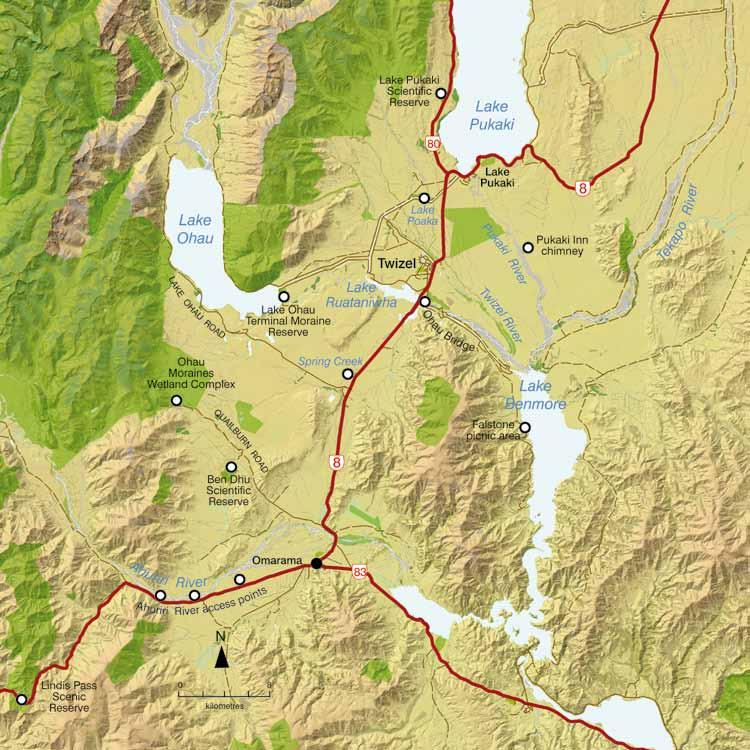
2 THE HUNTERS HILLS Separatio River Godley Macaulay River ROAD Lake Tekapo LILYBANK Lake Ohau Omarama Aoraki/Mount Cook Lake Pukaki Twizel Lake Benmore Lake Tekapo Burkes Pass Dobson River / Otao St Bathans Lake Pukaki Lake Aviemore Lake Alexandrina Tekapo River Kurow Pukaki River 8 85 Aoraki/Mt Cook Otematata 8 SOUTHERN ALPS / KĀ TIRITIRI O TE MOANA Tasman River / Te Awa Whakamau Twizel River Twizel River LAKE OHAU ROAD QUAILBURN ROAD Ahuriri River BIRCHWOOD ROAD BROKEN HUT RD Lindis Pass Public conservation land Information centre 0 8 N kilometres Hopkins River / Te Awa Āruhe page 15 page 12 page 18 page 17 page 7 page 8 page 10 page 8 page 14 page 11 page 6 page 4 page 5 page 6 Manuherikia River HAWKDUN RUNS ROAD


, Waihao (Waimate) and Moeraki migrated seasonally into the area from spring through to autumn.")
3 Day Walks in Mackenzie/Waitaki The Mackenzie Basin is the largest inter-montane (between mountains) basin in New Zealand and is part of the South Island high country. The basin is ringed with rolling, tussock-clad mountains and on a fine day the views are spectacular. Mackenzie Basin rivers all drain into the Waitaki River and out to the east coast near Oamaru. This region offers a large variety of walks, ranging from short ten-minute strolls to full-day walks. Some of the walks travel through private farmland so please keep to the marked tracks. The times and distances mentioned for each walk are for one direction only. Illustration: G Cox Many Māori travellers passed through this land Māori used the Mackenzie Basin for stone quarrying, eeling and hunting birds. People from the villages of Arowhenua (Temuka), Waihao (Waimate) and Moeraki migrated seasonally into the area from spring through to autumn. They also travelled across the basin between the west and east coasts, trading for pounamu (greenstone). Today, Ngāi Tahu have several traditional nohoanga camping sites ( a place to sit ) in the Mackenzie Basin. What to take The climate in Mackenzie Basin is traditionally very hot in summer and extremely cold in winter. New Zealand weather can change very rapidly, therefore walkers need to be prepared for a range of conditions. It is advisable to carry drinking water, a hat, 15+ sunblock, a raincoat and some warm clothing. Light footwear such as running shoes is suitable for most walks. High country stations are part of Mackenzie/Waitaki Some of the tracks profiled in this brochure venture across private farmland. Public access easements are in place so that you may reach public conservation land. In many instances you are walking through working high country stations. Please ensure you: stay on the public easement track leave gates as you find them do not disturb stock leave your dog at home take all rubbish away with you. Be a responsible dog owner Always keep your dog under control. Remove any dog droppings from tracks or track verges. Dogs are not allowed inside huts. Tie your dog up somewhere suitable outside. Check the pesticide summary to see if any poisons have been recently laid in the area you are visiting. Go to If passing through farmland help prevent the spread of sheep measles by keeping your dog regularly dosed with an effective tapeworm drug. Generally Droncit is used and given monthly in tablet form. Alternatively collect dog faeces and take to an appropriate waste disposal centre. Lake Tekapo ca 1910 Photo: Algernon Charles Gifford, Alexander Turnbull Library 2 3


4 4 Walks near Lake Tekapo Richmond Trail 4 5 hours, 13 km This walk starts and finishes in different areas so a couple of vehicles may be required or alternatively an arranged drop off/ pick up. Follow signage to Round Hill Ski Area on Lilybank Road. There is a car park area along the skifield access road. From here an initial walk of 3 km on the access road leads to the start of Richmond Trail. This trail travels along an old glacial terrace providing stunning views of Lake Tekapo and surrounding mountains. It is a steep descent back to Lilybank Road near Boundary Stream. How Mackenzie Basin got its name European history in the Mackenzie Basin began in 1855 with the arrest of a shepherd, James Mackenzie, for stealing sheep. Seeking a route for his flock he ventured inland and discovered the high country, which now bears his name. Mt John Summit Circuit Track 1 hour 30 min Mt John via lakeshore 3 hours The start of this track is located next to the Tekapo Springs complex. From the DOC sign walkers have the option of hiking directly up through the larch trees for the Summit Circuit Track or continuing on past Tekapo Springs for the Lakeshore Track. Mt John is a dominant feature of the Mackenzie Basin landscape. This small dome mountain is a roche moutonée, a rock formation which has been shaped by glacial ice flowing over it. On a clear day Mt John summit provides a fantastic viewing platform with a 360-degree panorama of the surrounding mountains, lakes and Mackenzie Basin flats. Mt John was named after an early farmer in the district, John Hay, who used to run Tekapo Station, the first sheep farm in the Mackenzie Basin. Part of the Tekapo Walkway has been made possible with the assistance of Balmoral Station and University of Canterbury. Please keep to the track. Peninsula Walkway 1 hour 30 minutes, 4 km This is a circuit track starting off Godley Peaks Road and leading to the end of a peninsula opposite Motuariki, an island in Lake Tekapo. This walk is a community initiative (it is not managed by DOC). 5


5 Cowans Hill Walkway Distance: 3.2 km This short track starts near the Tekapo Road bridge and caters for both walkers and mountain bikers. From the high point on this track walkers can appreciate the views of Lake Tekapo and surrounding mountains. Mary Burn access and Simons Hill Conservation Area 2 hours, 7 km one way A signposted car park denotes the start of this walk between Tekapo and Twizel, near Mary Burn. The track wanders beside Mary Burn so is popular with anglers, while walkers may continue on to the base of Simons Hill, a prominent landscape feature within Mackenzie Basin. Its eastern slopes contain shrublands of matagouri, small leaved Coprosma, prostrate kōwhai (Sophora prostrata) and Olearia odorata. This is a public access easement through private farmland so please keep to the track. 6 Big fires changed this landscape dramatically Before the arrival of people the dry Mackenzie Basin would have been covered with extensive grasslands, bush and shrubland, while trees such as beech and tōtara lined the mountain valleys. Fires caused by lightning strikes, Māori hunting for moa, and by early pastoral farmers meant the tall tussock and shrubs of the high-country basin gradually disappeared. Walks near Lake Pukaki Tasman River Track 3 hours, 10 km It is a long drive down Hayman Road (gravel), which becomes Braemar Mount Cook Station Road. There may also be stock beside the road and large vehicles, so travel carefully. The walk starts at the Jollie River car park and finishes at Tasman Point near Chop Creek. The track is popular with cyclists because it is part of the Alps 2 Ocean Cycle Trail. Note: The Alps 2 Ocean Cycle Trail travels from Aoraki/Mount Cook National Park through to Oamaru. For more information go to Jollie Hut 2 hours, 3 km Park your vehicle in the signposted car park off Braemar Mount Cook Station Road and continue on foot to Jollie Hut. Please keep to the track (public access easement). This area is popular with hunters looking for tahr and chamois further up valley. You are treading where ice once towered Over 10,000 years ago many of the formed walks near the large glacial lakes were once covered by glacial ice sheets. These glaciers shaped the landscape and scoured out valleys while leaving distinct terraces alongside the now-remaining lakes. The glacier-fed rivers that feed these high-country lakes carry glacial flour which is rock crushed by the glaciers and then held in suspension in the water giving the lakes their unusual turquoise colour. 7

 along the Lake Pukaki foreshore.")
 and Alps 2 Ocean Cycle Trail. Note: Te Araroa (The Long Pathway) is a walking trail from Cape Reinga to Bluff.")

6 Braemar Road to Landslip Creek 3 hours, 10 km There is a car parking area on Braemar Road for this walk. Follow the marked public access easement along the top of what is an old glacial terrace. A farm track leads to Landslip Creek and the public conservation land boundary. Keen walkers can hike uphill towards the trig station on point 1230 m. This is a further 3 km uphill and is a marked public access easement through Ministry of Defence land. Lake Pukaki foreshore 2 hours, 6.5 km It s certainly worth taking a short stroll (or cycle) along the Lake Pukaki foreshore. Seeing the view across Lake Pukaki to the Southern Alps/Kā Tiritiri o Te Moana on a fine day is not to be missed! This walk is a small section of both Te Araroa (The Long Pathway) and Alps 2 Ocean Cycle Trail. Note: Te Araroa (The Long Pathway) is a walking trail from Cape Reinga to Bluff. A 58-km section is marked from Tekapo to Twizel. For more information visit Punt on Lake Pukaki, ca 1890s Photo: Alexander Turnbull Library Pukaki Kettle Hole Track 1 hour circuit, 4 km This walk starts just north of the Pukaki River spillway. From the car park the walk follows a track into the Pukaki Scenic Reserve through moraine hummocks and leads to a distinct kettle hole. This kettle hole was formed by melting glacial ice interpretation signage on site provides information about this. The 360 views experienced along this track on a fine day are spectacular. Marker Bay 20 minutes, 1 km Marker Bay walk starts on the southern edge of Lake Pukaki just off SH8. It traverses an area where Lake Pukaki village once stood, before the lake levels were raised in Part of the track leads through pine trees and is a good stroll on a hot day. 8 9


7 Baikie Hut 3 hours, 9 km, 200 m vertical A car park for this track within Ruataniwha Conservation Park is off SH80 about 3.5 km from the SH8 turnoff. The track follows a 4WD road and is suitable for walkers, mountain bikers, runners and horse riders. Baikie Hut, resting on grassy flats beside Twizel River, has four bunks and provides a great overnight or picnic venue. Pukaki Boulders 10 minutes Access is along the Aoraki/Mt Cook highway approximately 5 km from the SH8 turnoff. A signpost and stile is on the Lake Pukaki side of the highway. A short track leads up to the Pukaki boulders. These boulders are called erratics and were deposited by the huge glacier that dominated the area over 12,000 years ago. Tibetan prayer flags are a memorial to several climbing guides from the local climbing fraternity. The boulders are popular with rock climbers and mountaineers driven away from Aoraki/Mt Cook National Park due to bad weather. 10 Walks near Twizel Pukaki Flats Conservation Area 2 hours, 6 km The Pukaki Flats area is 1.5 km north of Twizel. As its name suggests the Pukaki Flats walk is very flat over an open block of hard tussock grasslands. An old farm track follows a fence line and leads northeast to Pukaki River. This route forms part of Te Araroa (Long Pathway) from Twizel to Tekapo. The Alps 2 Ocean Cycle Trail also passes through here. Native plant species found here include mat daisies, native broom, blue tussock and native daphne. The views from here looking to Ben Ohau Range and the Southern Alps/Kā Tiritiri o Te Moana are stunning on a fine day. Twizel River Trail 3 4 hours, 12 km Twizel River Trail is located opposite Twizel on the eastern side of SH8. The river is intermittently lined with willow trees which provide plenty of shade. While the trail is popular with anglers and mountain bikers, walkers may also enjoy the opportunity to find uncrowded swimming holes and picnic spots. Please keep to the track (public access easement). Native fish such as the Canterbury galaxias (Galaxias vulgaris) and upland bully (Gobriomorphus breviceps) inhabit Twizel River, along with introduced trout. 11


8 Braided rivers are unique and rare Extensive braided-river systems such as those found in New Zealand also occur in Alaska, Canada, Iceland and the Himalayas but are uncommon internationally. Canterbury contains 60% of the braided river habitat in New Zealand with Mackenzie Basin having some of the most pristine of these rivers. The plants and animals found in braided rivers have adapted to this tough, open, and often windy environment. From high up on Ben Ohau Peak/Ruataniwha it is possible to look down upon both the Hopkins/Te Awa āruhe and Dobson/ Otao braided rivers as they drain into Lake Ohau. Dusky Trail 7 8 hours, 23 km Dusky Trail starts off Glen Lyon Road west of Twizel. This is a popular trail for mountain bikers. You will get wet feet crossing both Fraser Stream and Twizel River. This walk is not recommended after heavy rainfall. Where sections of this trail go through private land, please keep to the track. 12 Native fish are hard to spot Within the high-country rivers and lakes lie many species of freshwater fish, including native species such as bullies, eels, and galaxiids. The majority of these fish are quite small and like to hide during daytime so they often go unnoticed. One widespread native fish, kōaro (Galaxias brevipinnis), has adapted to being landlocked in Mackenzie Basin and breed in tussock streams that flow into high-country lakes (mature fish cannot migrate to the coast past the dams). Kōaro Flanagan Pass Trail 20 km, 685 m vert, 8 hrs This track starts from a designated car park area on Glen Lyon Road. You walk through exotic forest and then ascend a short, steep track to Pyramid Saddle. Descend from the saddle to Darts Bush flats before a long climb up to Flanagan Pass (1225 m). The trip over Flanagan Pass (formerly known as Glen Lyon Saddle) was regularly used in the late 1800s as a direct route to Glen Lyon Station. Remaining telegraph poles from the 1940s can be seen beside the track in places. They once provided communication for the station. A grassy, diagonal descent leads down to Lake Ohau. Twizel Walkway 3 hours, 9 km circuit This walk circles the Twizel township and in part follows Twizel River. A great aerial view is provided from Man Made Hill. This walk has 13


9 been extended to Lake Ruataniwha. The Track is well marked (and may be joined at many parts around the town) a detailed map is available from Twizel Information Centre. Walks near Lake Ohau Twizel the early days Photo: M Sheridan A basin without formed roads made early travel difficult The Mackenzie Plains were wide open, with very few fences, and the bullocks hauling the wagons were free to zigzag their way over the plains in the general direction of the river fords. The coaches followed the erratic tracks made by the bullock wagons. The tracks were largely unformed and unmetalled and in the spring, when the ground was starting to thaw after being icebound all winter, they became quagmires. Excerpt from The Mount Cook Way by Harry Wigley Ben Ohau/Ruataniwha Greta Track 6 7 hr, 16 km circuit, 810 m vert A car park area for this track is found off Glen Lyon Road (gravel). Drive carefully as this road is narrow in places. Remnant beech/tawhai forest, mānuka, tōtara and an old musterer s hut from the 1890s makes for an interesting start to this track. It is a 5 km climb up the western flank of Ben Ohau/Ruataniwha peak (walkers will need to deviate from the track to climb to the true summit at 1522 m). The initial descent into Gretas Stream is quite steep. This part of the track passes by fellfields (blocky scree) and short rock bluffs back down to Lake Ohau. You need to cross Gretas Stream a few times so you will get wet feet. Dorcy Stream Track 2 hours, 4 km, 460 m vertical You can either start walking from Old Glen Lyon Road or take your 4WD up to the airstrip parking area. It is 1 hour 30 minutes walking from the airstrip to Flanagan Pass (1225 m)


10 Lake Ohau Track 3 hr, 8 km A magnificent walk along the shores of Lake Ohau combined with breathtaking views of the mountains! Start at either Ohau River Weir or Lake Ohau Road. This track is part of Alps 2 Ocean Cycle Trail. Freehold Creek Track Parsons Creek Freehold Creek bushline 2 hours, 6 km, 560 m vert Mountain beech forest clings to the gullies alongside Freehold, Parsons and Sawyers creeks in this area. The new Alps 2 Ocean Cycle Trail travels from Lake Ohau Lodge and continues on past Freehold Creek. Look out for the DOC sign just before Parsons Creek one-lane bridge on Lake Ohau Road. This is a good place to stop and see native mistletoe/pirirangi on the mountain beech trees (flowering season is November/ December). From Parsons Creek the track meanders along ancient glacial moraine terraces. Once across the Freehold Creek bridge you are walking on an old beech logging trail. Note the distinctive curved nature of the track which is where bullocks (young bulls) dragged large beech and tōtara logs from the forest. 16 Mistletoe/pirirangi Glen Mary Ski Club Huts access Sawyers Creek track 45 minutes, 2 km This track provides a direct route to Sawyers Creek where it meets the Alps 2 Ocean Cycle Trail and then on to Freehold Creek. This is also part of Te Araroa Trail. Please park in the signposted area near Lake Ohau Road (not by the huts). Walks near Omarama Wairepo Kettleholes 1 hour, 3 km The entry point to the Wairepo Kettleholes is 14 km along Quailburn Road and is well signposted (Quailburn Road starts approximately four kilometres north of Omarama off SH8). There is ample room for off-road parking. The initial track is a public access easement through private farmland and follows the formed road. A stile leads over into the conservation area and from here it is a short distance to the kettleholes. These kettleholes provide an important feeding area for a number of key bird species including kakī/black stilt. Also in the conservation area are fragmented patches of red tussock particularly alongside Wairepo Creek. The wilding pine tree is a foreign invader Unwanted pine trees that spread from their own seed source are known as wildings. A constant curse Ground of Mackenzie beetle and Waitaki basins these trees were introduced for their timber and catchment protection purposes. The most prevalent pine is Pinus contorta known as lodgepole pine in its native homeland of North America. Here it grows extremely rapidly and is known as a weed, displacing our native plants and animals. Volunteers have spent many hours clearing wilding pine trees from the Wairepo Kettlehole Conservation Area with very positive results. 17


11 Quailburn Historic Area Historic area Quailburn bushline minutes, 1.5 km, 160 m vertical Quailburn Historic Area within Ahuriri Conservation Park is found at the end of Quailburn Road. The historic site has a woolshed, sheep dip, homestead and hut ruins dating from A short track through beech forest involves crossing Quailburn Stream and provides a viewpoint above the bushline. 18 Wether Range 2 hours, 7 km A sign along Shortcut Road shows the start of the route into the Wether Range. Follow a public access easement through private farmland along the fenceline boundary. There is no formed track within the public conservation land. A diverse selection of native scrub covers the flats near Manuka Creek which runs through here. Ewe Range Track 3 hours, 7 km, 650 m vertical Ewe Range Track, within Oteake Conservation Park, is located at the end of Broken Hut Road, south of Omarama. The track starts past the conservation park car park area. It is a steep climb up this track to the top of Ewe Range, however all that effort is rewarded with striking views amongst protruding rock outcrops. 19


12 Dromedary Hill SH8 car park to Dromedary Hill summit 6 hours, 10 km, 1000 m vertical Look out for a signposted car park near Dalrachney Road bridge, approximately 20 km south of Omarama. A marked track leads to the summit of Dromedary Hill (1664 m) in Lindis Conservation Area. The views on the ascent are spectacular, with Mt Barth in Ahuriri Conservation Park clearly visible on a good day. Many birds depend upon our rivers Walking alongside rivers and wetland areas you may be fortunate enough to see many different birds. River birds such as banded dotterel/turiwhatu, South Island pied oystercatcher/tōrea, spur-winged plover, black-fronted tern/tarapirohe, southern blackbacked gull/karoro and paradise shelduck/pūtakitaki frequent riverbed areas. Meanwhile Australasian harrier/kāhu are a common sight, especially along roadsides. Black-fronted tern/tarapirohe Illustrations: Simone End Walks near Lake Benmore Common skink Photo: D Sanderson Open tussock grasslands support Ground beetle a variety of animal species The dry, stony, tussock country along some of the walks sustains many different insects and lizards that rely upon this type of habitat. Grasshoppers, beetles, butterflies, moths, and skinks may often be seen on a hot summer s day. Otamatakou Scenic Reserve 2 hours, 5.5 km This walk follows Glen Creek and is found off SH83 near Lake Benmore. The reserve itself contains many remnant native shrubs including Hebe cupressoides, matagouri, mountain wineberry, Coprosma propinqua, Corokia cotoneaster and Olearia virgata. While there are no defined tracks within the reserve it is still a great place to see many different species of native plants and imagine what the area must have looked like hundreds of years ago


13 More places of interest/ picnic spots See map page 26 Lake Pukaki Scientific Reserve Look out for this area found off Aoraki/Mount Cook highway. There is no defined track. Benmore Peninsula 1 hour 30 min, 4 km Access to the circuit track is from Otematata via the road end above Benmore hydroelectric dam. This walk travels through an exotic forest and around a peninsula jutting out into Lake Benmore. Walks near Kurow Deep Stream 1 hour, 2 km This track is found along Te Akatarawa Road. The track sidles steep faces within a flooded canyon. Plants you may see include prostrate kōwhai (Sophora prostrata), which flowers in August/ September, and two rare native brooms, Carmichaelia curta and Carmichaelia kirkii both threatened species. This walk finishes at the river delta where a shady picnic or fishing spot can be found. Pukaki Inn chimney You will need a 4WD vehicle to drive to this site. From SH8, north of the Lake Pukaki spillway, travel 7 km down a gravel road and the chimney is approximately 20 m from the road verge making it easy to spot. This chimney is all that remains from one of the original accommodation houses in the area (thought to be constructed in the 1920s). Lake Poaka Located alongside the Pukaki Canal this lake is a popular picnic area. Many waterfowl make the lake their home so please keep your dog on a lead. Lake Ruataniwha Located immediately south of Twizel off SH8. With driving access around most of the lake there are plenty of picnic and swimming spots


14 Ohau Bridge The access road for Ohau Bridge is found near the Meridian Energy offices and is signposted Iron Bridge Road. Ohau Bridge is the last surviving engineering structure of its type in this region. Built in 1890, the bridge is still sturdy and spans a small lake. Lake Ohau Terminal Moraine Reserve A good place to stretch your legs in autumn and winter when the dominant westerly winds abate. Lake Ohau Terminal Moraine reserve is reached off Ohau Canal Road. Cross the Lake Ohau spillway and drive up the hill to the signposted car park area. A 4WD track travels along the edge of Lake Ohau. Spring Creek A great stop-off area for a picnic or to explore; this small area of public conservation land is signposted off SH8 about 12 km south of Twizel. Once through the gate off State Highway 8 there is an old farm track that leads to the wetland area. A hundred hectares of fescue tussock grassland are protected, as well as a small area of carex wetland. It is possible to walk to the western boundary by following the southern fence line which avoids wet areas. Falstone Picnic Area Located beside Lake Benmore, this is a lovely place for a picnic and swim. 24 Ohau Moraines Wetland Complex Nestled under the Ohau Range, Ohau Moraines Wetland Complex is part of Ahuriri Conservation Park and found near the end of Quailburn Road. This vast expanse of red tussock lands, wetlands, rolling moraines and outwash flats provides a great place to explore. The Alps 2 Ocean Cycle Trail passes through here. Ben Dhu Scientific Reserve A marked public access easement leads into this reserve from Quailburn Road. You may get wet feet crossing a small stream on the way in. Ahuriri River access Old fence tag As you travel south past Omarama there are several places signposted off SH8 providing access down to Ahuriri River. Likewise within Ahuriri valley itself, there are places clearly marked where you can access the Ahuriri River before you reach Ahuriri Conservation Park. Look out for these areas and please keep off private farmland in the valley. Lindis Pass Scenic Reserve This reserve is found beside the Lindis Pass highway. There is no defined track. The Hunters Hills/Te Tari a Te Kaumira Look out for the car parking area off Hakataramea Valley Road, this is approximately 50 km north of Kurow. Old farm tracks between Nessing Stream and Cabbage Tree Gully give good access up to The Hunters Hills. 25
15 26 27


16 Conservation volunteers C h eck, C lea n, D ry Stop the spread of didymo and other freshwater pests. Remember to Check, Clean, Dry all items before entering, and when moving between, waterways. More information Backcountry tramping information is covered in Te Kahui Kaupeka, Ruataniwha, Oteake and Ahuriri conservation park brochures. These four parks are accessible from Mackenzie/Waitaki region. The Department of Conservation works closely with many community groups, trusts and other agencies to further conservation projects on and off public conservation lands. Many of these groups rely heavily on volunteers to plant trees, maintain facilities and restore precious areas. If you would like further information on volunteering opportunities visit 28 Twizel Information Centre C/- Twizel Events Centre Market Place TWIZEL Phone: info@twizel.info Department of Conservation Wairepo Road TWIZEL Phone: Fax: TwizelAO@doc.govt.nz For further information about recreation activities and conservation visit: Suggestions for corrections or improvements should be ed to: recreation@doc.govt.nz Protect plants and animals Remove rubbish Bury toilet waste Keep streams and lakes clean Take care with fires Camp carefully Keep to the track Consider others Respect our cultural heritage Enjoy your visit Toitu te whenua (Leave the land undisturbed) 29
Around and about Geraldine
 Around and about Geraldine A guide to recreational opportunities SOUTH CANTERBURY Track classifications Short walk Easy walking for up to an hour Track is well formed, with an even, welldrained surface.
This area is a popular holiday spot so watch out for 4WD vehicles and motorbikes at peak times.
 Mavora Walkway (Map 130, 129, 128) Southern Start Northern End Distance Time Track Standard Mavora Camping Area, Mavora Lakes Road Greenstone Station Road Carpark 50km 3 days Tramping track Hazards Never
Te Manahuna Consulting
 Assessment of the natural values at the proposed centre pivot irrigation site and surrounds on Ben Ohau Station, Mackenzie Basin, New Zealand August 2016 Abstract The natural values of the area proposed
East West route and Leatham Molesworth route (route guide) Molesworth Recreation Reserve
 Molesworth Recreation Reserve") East West route and Leatham Molesworth route (route guide) Molesworth Recreation Reserve 0BIntroduction The East West route links the Clarence (Kahutara River in Ka Whata Tu o Rakihouia) Conservation Park
East West route and Leatham Molesworth route (route guide) Molesworth Recreation Reserve 0BIntroduction The East West route links the Clarence (Kahutara River in Ka Whata Tu o Rakihouia) Conservation Park
18Day Road Tour Christchurch to Christchurch
 18Day Road Tour Christchurch to Christchurch Route: Christchurch Farlie Lake Tekapo Twizel Wanaka Queenstown - Te Anau Milford Sound - Manapouri Queenstown Wanaka Haast Fox Glacier Franz Josef Hokitika
Contents. this edition May Lake Tekapo 4 Mt John Walks 6 Tekapo Town Walks 8 Lake Alexandrina 9 Macaulay River & Two Thumb Tops
 Contents this edition May 2010 Tekapo 4 Mt John Walks 6 Tekapo Town Walks 8 Alexandrina 9 Macaulay & Two Thumb Tops Mt Cook & Pukaki 11 Kea Point 12 Sealey Tarns & Mueller Hut 13 Hooker Valley Walks 15
NOHOANGA SITE INFORMATION SHEET LAKE PŪKAKI, SOUTH CANTERBURY. Getting there
 NOHOANGA SITE INFORMATION SHEET LAKE PŪKAKI, SOUTH CANTERBURY Getting there The site is at the bottom of Lake Pūkaki, near Twizel in the McKenzie Country. From Twizel, cross the Pūkaki High Dam and take
Discover. Sledge Track Essence of Aotearoa
 Discover Sledge Track Essence of Aotearoa Discover Manawatu s timeless walkway adventure. Lying in the heart of the scenic Kahuterawa Valley, Sledge Track brings you face to face with the majesty of New
Walking tracks. in Aoraki/Mount Cook National Park
 Walking tracks in Aoraki/Mount Cook National Park Contents Welcome to Aoraki/Mount Cook National Park 1 Be prepared 3 Walks from the village and campground 5 Freda du Faur 9 Walks map 10 Village walks
Around and about Mid-Canterbury
 Around and about Mid-Canterbury A guide to recreational opportunities mid canterbury www.doc.govt.nz Published by Department of Conservation Canterbury Conservancy Private Bag 4715 Christchurch, New Zealand
Waiau Pass Track. (Map 92, 91, 90, 89, 88, 87)
") Waiau Pass Track (Map 92, 91, 90, 89, 88, 87) Southern Start Northern End Distance Time Track Standard Boyle Village St Arnaud Village 115.5km 5-8 days Tramping track At 1870m, Waiau Pass is the most likely
Waiau Pass Track (Map 92, 91, 90, 89, 88, 87) Southern Start Northern End Distance Time Track Standard Boyle Village St Arnaud Village 115.5km 5-8 days Tramping track At 1870m, Waiau Pass is the most likely
The Mackenzie Basin ecology and protection
 The Mackenzie Basin ecology and protection Photo Chris Woolmore Nicholas Head Plant Ecologist Acknowledgements Warren Chinn, Joy Comrie, Iain Gover, Di Lucas, Brian Patrick, Geoff Rogers, Susan Walker,
The Aotea Track offers a range of spectacular landscapes, superb views and rich history.
 Aotea Track Located in Great Barrier Island/Aotea in the Auckland region The Aotea Track offers a range of spectacular landscapes, superb views and rich history. Travel over streams that show off a constant
Discover. Ashhurst Domain. Nature s Playground
 Discover Ashhurst Domain Nature s Playground Discover Step back into New Zealand, Aotearoa, of generations long gone. Discover lush natural surrounds echoing with rich birdsong in one of the Manawatu s
Nine-Day Southern Spectacular: Tour Inclusions:
 Nine-Day Southern Spectacular: Tour Inclusions: Meet and Greet on arrival in New Zealand New Zealand Airport Transfers Quality hotel accommodation, twin/double rooms, (single rooms available with single
Back Country Real Estate. Central Otago. Back Country
 Back Country Real Estate Central Otago Back Country 6-12 February 2017 Itinerary Join us on a new adventure as we discover the magnificent back country of the Central Otago region. We do however stress
HIKING IN THE CANADIAN ROCKIES
 HIKING IN THE CANADIAN ROCKIES Distance Time Elevation y MORAINE LAKE TRAILS THE ROCKPILE 0.8 km (0.5 mi) 20 min 30 m (98 ft) Located adjacent to the Lodge, the short interpretive trail up the Rock Pile
Little Grand Canyon near Pomona, Illinois
 Little Grand Canyon near Pomona, Illinois Below: View of the trail and the terrain created using the Map My Hike app Below: Summary of the hike created using the Map My Hike app Presented by: Jennifer
The Hunters Hills/Te Tari a Te Kaumira. South Canterbury
 The Hunters Hills/Te Tari a Te Kaumira South Canterbury Contents Takata whenua first people of the land 1 European history 2 Native plants & animals you might see 2 Track grades 4 Safety is your responsibility
Potential additions to Aoraki/Mount Cook National Park and the World Heritage Area
 Topic Paper: Potential additions to Aoraki/Mount Cook National Park and the World Heritage Area. Purpose This paper provides the relevant background and matters for consideration regarding potential additions
EARLY BIRD SPECIAL BOOK EARLY & SAVE! Merinos near Tekapo. Southern Lakes and Canterbury High Country
 EARLY BIRD SPECIAL BOOK EARLY & SAVE! Merinos near Tekapo Southern Lakes and Canterbury High Country 6-14 April 2018 Itinerary Day 1: Friday 6 April -Travelling to Queenstown An early start from all destinations
Public conservation land inventory Canterbury Map table Conservation Unit Name Legal Status Conservation Unit Area. Conservation Unit number
 Public conservation land inventory Map table 6.11 Conservation Unit number Conservation Unit Name Legal Status Conservation Unit Area Legal Description Description N33022 Gravel Reserve Antrim Hills RALP
TREK THE ROCKIES ABOUT THE CHALLENGE TREK THE ROCKIES FOR HIGHLAND HOSPICE CANADA TREK DEMANDING
 TREK THE ROCKIES CANADA TREK DEMANDING ABOUT THE CHALLENGE The Canadian Rockies are justifiably world-famous for their magnificent scenery: the combination of impressive, jagged mountains, bright turquoise
Park-specific management and policies Wainuiomata Recreation Area
 Park-specific management and policies Wainuiomata Recreation Area 6.8 Wainuiomata Recreation Area 6.8.1 Legal status Title held: Legislative status: Wellington Regional Council Administered under Local
A Publication of Friends of Sleeping Bear Dunes
 A Publication of Friends of Sleeping Bear Dunes 2014, Friends of Sleeping Bear Dunes, P.O. Box 545, Empire, MI 49630 www.friendsofsleepingbear.org info@friendsofsleepingbear.org Learn more about the Friends
Staples Lookout to Mt Wondabyne loop
 Staples Lookout to Mt Wondabyne loop 4 hrs 3 mins 1.8 km Circuit Hard track 337m This walk starts and finishes at Staples Lookout, on Woy Woy Rd. The walk follows sections of the Great North Walk around
Self-Guided Walk Langdale Pikes. Start & Finish: NT car park (free to members) at Sticklebarn - on the right just beyond the New Dungeon Ghyll hotel.
 at Sticklebarn - on the right just beyond the New Dungeon Ghyll hotel.") Self-Guided Walk Langdale Pikes Key Information These mountains form a collection of spires and cliffs on the north side of Langdale. This walk visits four of the main tops Pavey Ark, Harrison Stickle,
Self-Guided Walk Langdale Pikes Key Information These mountains form a collection of spires and cliffs on the north side of Langdale. This walk visits four of the main tops Pavey Ark, Harrison Stickle,
Kuruwita Erathna Trail to Sri Pada (Adam s Peak)
") Kuruwita Erathna Trail to Sri Pada (Adam s Peak) Trail Difficulty: Easy Moderate Strenuous Tough Trail Head: Adevikanda, Erathna (near entrance to mini-hydro power plant) Nearest Town: Erathna Nearest
Kuruwita Erathna Trail to Sri Pada (Adam s Peak) Trail Difficulty: Easy Moderate Strenuous Tough Trail Head: Adevikanda, Erathna (near entrance to mini-hydro power plant) Nearest Town: Erathna Nearest
New Zealand's South Island Photographic Expedition
 New Zealand's South Island Photographic Expedition DAY 1: PRE-TOUR NIGHT: Arrive at Christchurch Airport and take the shuttle service or a taxi to your preferred Christchurch hotel. Once you arrive and
GOLDEN EARS PROVINCIAL PARK
 GOLDEN EARS PROVINCIAL PARK Trail Information as of October 10 th 2015 Do not underestimate the mountainous wilderness of Golden Ears Provincial Park. The combination of rugged terrain and rapidly changing
Summary of Preliminary Proposal
 Crown Pastoral Land Tenure Review Lease name : SIMONS PASS Lease number : PT 019 Summary of Preliminary Proposal A Preliminary Proposal is advertised for public submissions as per Section 43 of the Crown
Note: Coordinates are provided as Universal Transverse Mercator UTM Zone U21, North American Datum 1983 (NAD 83).
.") Northern Traverse Route Description The Northern Traverse (formerly the North Rim Traverse) is an unmarked and rugged backcountry hiking route. It is known be a demanding hike, because of its terrain and
Northern Traverse Route Description The Northern Traverse (formerly the North Rim Traverse) is an unmarked and rugged backcountry hiking route. It is known be a demanding hike, because of its terrain and
Significant Natural Area Assessment. Property Name: Hillend Station
 Private Bag 50072, Queenstown 9348, New Zealand QUEENSTOWN, 10 Gorge Road, Phone +64 3 441 0499, Fax +64 3 450 2223 WANAKA, 47 Ardmore Street, Phone +64 3 443 0024, Fax +64 3 450 2223 Significant Natural
Hawke s Bay Regional Parks Network. Pekapeka Regional Park Individual Park Plan
 Hawke s Bay Regional Parks Network Pekapeka Regional Park Individual Park Plan 2015-2024 Hawke s Bay Regional Council 159 Dalton Street Private Bag 6006 Napier 4110 Hawke s Bay New Zealand Telephone: 0800
Beautiful Walks from the Blue Ball Inn
 Walk No. 2 WINSTONS WALK Countisbury, Wind Hill, Watersmeet, Ash Bridge and Winston s path. 5 Miles approx. Walking time- Two and a half hours approx. (Not including Breaks) OS 1:25,000 Sheet 64/74 Lynton
A summary of Draft Makara Peak Mountain Bike Park Master Plan
 A summary of Draft Makara Peak Mountain Bike Park Master Plan OVEMBER 216 Image: Peter Marshall 2 3 Introduction Since it was established in 1998, the Makara Peak Mountain Bike Park (Makara Peak) has grown
THE THREE PEAKS OF TANZANIA
 THE THREE PEAKS OF TANZANIA Longido, Mt Meru, and Kilimanjaro in 13 days Day 1 Arrival Longido approx 10kms trekking FBA can arrange your flights to Nairobi or Kilimanjaro. If booking your own flights,
Stok Kangri Peak (6120m) 2 to 16 September 2018 Explore the hidden kingdom of Ladakh with Stok Kangri Peak
 2 to 16 September 2018 Explore the hidden kingdom of Ladakh with Stok Kangri Peak") Stok Kangri Peak (6120m) 2 to 16 September 2018 Explore the hidden kingdom of Ladakh with Stok Kangri Peak Stok Kangri is a perfect objective for fit trekkers without climbing experience, and is one of
Stok Kangri Peak (6120m) 2 to 16 September 2018 Explore the hidden kingdom of Ladakh with Stok Kangri Peak Stok Kangri is a perfect objective for fit trekkers without climbing experience, and is one of
Discover... Sledge. Track. Essence of Aotearoa. You ll find there s much more than meets the eye!
 Sledge Discover... Track Essence of Aotearoa You ll find there s much more than meets the eye! Discover... Manawatu s timeless walkway adventure. Lying in the heart of the scenic Kahuterawa Valley, Sledge
Driving Time: 3 hours (allow extra time for stops)
") Scenic Byways loop This journey takes visitors through the eastern edge of Mt. Rainier National Park and along two of Washington s most beloved scenic byways, the Chinook Byway and the White Pass Scenic
Scenic Byways loop This journey takes visitors through the eastern edge of Mt. Rainier National Park and along two of Washington s most beloved scenic byways, the Chinook Byway and the White Pass Scenic
Illawarra Escarpment State Conservation Area Walking Tracks
 Illawarra Escarpment State Conservation Area Walking Tracks NPWS Illawarra Area Office Ground Floor, Government Office Block 84 Crown Street Wollongong NSW 2500 02 4223 3000 (Mon-Fri) Royal National Park
GIFFORD PINCHOT NATIONAL FOREST
 GIFFORD PINCHOT NATIONAL FOREST 9341 Wright Meadow 93 Spencer Meadow Spencer Butte 4247' 30 30A 19 24 80 31C Lewis River Lower Falls 5 Quartz Creek 90 Taidnapam Falls Upper Falls 31 Spencer Peak 3861'
Darwin s gigantic blunder
 Trail Darwin s gigantic blunder Explore how ice shaped the landscape and why Charles Darwin made a nice mess of Glen Roy Time: 1hr 10 mins Distance: 2 miles Landscape: rural At Glen Roy a curious feature
KETTLE CREEK CONSERVATION AUTHORITY TRAIL GUIDE.
 KETTLE CREEK CONSERVATION AUTHORITY TRAIL GUIDE www.kettlecreekconservation.on.ca EXPLORE OUR TRAILS HIKE OUR TRAILS Kettle Creek Conservation Authority (KCCA) proudly supports and promotes an active lifestyle
RIDGELINE HOMESTEAD & ECO SANCTUARY WANAKA NEW ZEALAND
 RIDGELINE HOMESTEAD & ECO SANCTUARY WANAKA NEW ZEALAND We are delighted to introduce you to the Ridgeline Homestead, Cottages and Eco Sanctuary at Mahu Whenua. Located in New Zealand s South Island, just
Wanaka Outdoor Pursuits
 Welcome to Wanaka Wanaka is one of Otago s most popular holiday spots. A spectacular place for recreation: mountains, lakes and rivers for all to enjoy and explore. Warm summers are ideal for the region
7 Day Luxury Southern Lakes Adventure
 Enjoy seven days of indulgent luxury and South Island adventure. Stay at the renowned Blanket Bay Lodge, near Queenstown, and soak in the tranquil atmosphere of this peerless lakeside retreat. A private
B HALL RANCH FISHTAIL, MONTANA
 Brochure Courtesy of: B HALL RANCH FISHTAIL, MONTANA w w w. m c c a s l i n l a n d. c o m Page 1 LOCATION The Hall Ranch is ideally located in the foothills of the Beartooth Mountains, approximately 5
Trail Phasing Plan. Note: Trails in the Clear Creek Canyon area (Segments will be finalized in the future to minimize wildlife impacts
 Note: Trails in the Clear Creek Canyon area (Segments 2 5 and a future JCOS connection) will be finalized in the future to minimize wildlife impacts Trail Phasing Plan P Parking 3 Easy Trail Intermediate
Lava Mountain Trail Distance: Elevation Range: Trail Type: Difficulty: Season: Driving Distance: Driving Time: USGS Maps: Pros Cons
 Lava Mountain Trail Distance: 13.4 miles (including the side trip to North Star Lake) Elevation Range: 5900'-8330' Trail Type: singletrack Difficulty: moderate Season: late June-October Driving Distance:
Main Range Walk - Charlotte Pass to Mount Kosciuszko
 Main Range Walk - Charlotte Pass to Mount Kosciuszko 9 hrs Hard track 21.9 km Circuit 4 920m This full day walk explores some of the greatest alpine country on offer in NSW. The walk grants views of Blue,
NOHOANGA SITE INFORMATION SHEET LAKE HAWEA TIMARU RIVER (TIMARU CREEK) Getting there
 Getting there") NOHOANGA SITE INFORMATION SHEET LAKE HAWEA TIMARU RIVER (TIMARU CREEK) Getting there From the West Coast Wanaka highway (SH6), turn off at the dam and drive through Hawea Township until you join up with
NOHOANGA SITE INFORMATION SHEET LAKE HAWEA TIMARU RIVER (TIMARU CREEK) Getting there From the West Coast Wanaka highway (SH6), turn off at the dam and drive through Hawea Township until you join up with
Steps in the Management Planning Process
 Steps in the Management Planning Process Developing a management plan for Kalamalka Lake Park will follow a multi-stage process. The planning process for this park is currently in the Draft Management
The gorges of Mohican Park in Ohio create a hiker's paradise Sunday, May 22, 2011 By Bob Downing, Akron Beacon Journal
 Pittsburgh Post-Gazette The gorges of Mohican Park in Ohio create a hiker's paradise Sunday, May 22, 2011 By Bob Downing, Akron Beacon Journal Bob Downing Big Lyons Falls drops 80 feet into a shady U-shaped
beach. Make the ford and follow the trail out to the junction with Red Creek Tr in an open grassy area.
 Description: This is a moderate to slightly strenuous 22.8 mile backpack (add 2.6 miles if you do the packless out and back to the Lion s Head) that will have you exploring nearly every thing that is The
IRON BARK and COLENSO HUTS 260 Series Map: 1:50, U21 NZ Grid GPS: Geodetic Datum 1949
 IRON BARK and COLENSO HUTS 260 Series Map: 1:50,000 260-U21 NZ Grid GPS: Geodetic Datum 1949 Topo50 Map: BK36 Taoroa Junction GPS: on WGS84 How to get to START: Exit Taupo on SH1 down the lake to Turangi
Congewai Track Head (East) to Watagan Headquarters
 to Watagan Headquarters") Congewai Track Head (East) to Watagan Headquarters 7 hrs Hard track 17.2 km One way 4 973m This full day walk starts from the Congewai valley trackhead (east) and follows the Great North Walk up into the
Congewai Track Head (East) to Watagan Headquarters 7 hrs Hard track 17.2 km One way 4 973m This full day walk starts from the Congewai valley trackhead (east) and follows the Great North Walk up into the
Guthega to Mt Twynam. 2183m. 1583m. 6 hrs 45 mins 14.8 km Return. Experienced only. 913m
 Guthega to Mt Twynam 6 hrs 45 mins 14.8 km Return Experienced only 5 913m This walk starts from Guthega and makes its way along the Snowy River to the Illawong Lodge, via the Blue Cow Creek flying fox.
RIDGELINE HOMESTEAD & ECO SANCTUARY WANAKA NEW ZEALAND
 RIDGELINE HOMESTEAD & ECO SANCTUARY WANAKA NEW ZEALAND We are delighted to introduce you to the Ridgeline Homestead, Cottages and Eco Sanctuary at Mahu Whenua. Located in New Zealand s South Island, just
This Passport: Revised October 20, 2017, EAM # Discovering the Trails of Webster, NY
 This Passport: Revised October 20, 2017, EAM #161923 Discovering the Trails of Webster, NY The Town of Webster invites you to explore and experience our diverse outdoor adventures! Here s your opportunity
TE WAIPOUNAMU SOUTH ISLAND 2017/2018
 TE WAIPOUNAMU SOUTH ISLAND 207/208 Responsible camping You could get a $200 instant fine by: Freedom camping overnight where there is a no camping sign. Freedom camping overnight where there is a self-contained
Countryside Trails Dunkeld
 R A N G E R S E RV I C E Countryside Trails Dunkeld WELCOME Welcome to this southern end of Atholl Estates. The countryside here is a wonderful blend of lochs, woodland and heather moor. There is a large
Leaden Boot Challenge ROUTE INSTRUCTIONS
 Leaden Boot Challenge ROUTE INSTRUCTIONS Section 1 Alstonefield to Ilam From the village hall car park turn R then L and pass through the village keeping to the R to enter Church Street. Pass the Church
Adventure Travel Trip Itinerary
 Adventure Travel Trip Itinerary Mt. Kilimanjaro & Mt. Meru Climbs, Tanzania July 8 23, 2017 Leader: Bill Blazek Date Activity (distances are approximate) Accommodation, Notes Meals 1 Saturday July 8, 2017
1.1.1 Landscape character This is the upper part of a bowl-shaped landform, extending east from the Rothiemurchus character area, contained by the
 1.1 Glen More 1.1.1 Landscape character This is the upper part of a bowl-shaped landform, extending east from the Rothiemurchus character area, contained by the arc of the high granite pluton of the Cairngorms
playwinterpark.com Off The Beaten Path Hikes Hiking Recommendations for the Adventurous Hiker
 playwinterpark.com Off The Beaten Path Hikes Hiking Recommendations for the Adventurous Hiker Hike: Devil s Thumb (difficult) Length: 3.93 miles one-way Elevation: Trailhead 9609 Destination 12,236 Trailhead
RIDGELINE HOMESTEAD & ECO SANCTUARY WANAKA NEW ZEALAND
 RIDGELINE HOMESTEAD & ECO SANCTUARY WANAKA NEW ZEALAND We are delighted to introduce you to the Ridgeline Homestead, Cottages and Eco Sanctuary at Mahu Whenua. Located in New Zealand s South Island, just
Main Range Track - Loop from Charlotte Pass camping near Mt Townsend
 Main Range Track - Loop from Charlotte Pass camping near Mt Townsend 2 Days Experienced only 27.7 km Circuit 5 1260m This great overnight walk starts from Charlotte Pass and provides access to some of
Chapter 7 Geography and the Early Settlement of Egypt, Kush, and Canaan
 Chapter 7 Geography and the Early Settlement of Egypt, Kush, and Canaan How did geography affect early settlement in Egypt, Kush, and Canaan? Section 7.1 - Introduction RF/NASA//Corbis This satellite photograph
Pembina Valley Provincial Park. Draft Management Plan
 Pembina Valley Provincial Park Draft Management Plan 2 Pembina Valley Provincial Park Table of Contents 1. Introduction... 3 2. Park History... 3 3. Park Attributes... 3 3.1 Natural... 3 3.2 Recreational...
Kitimat. Pacific Inland Coast. Hiking Guide Kitimat, British Columbia, Canada
 Kitimat Pacific Inland Coast Hiking Guide Kitimat, British Columbia, Canada 2010-2011 Sites and Trails Emergency Call 911 Police - Fire - Medical 2 Welcome to Kitimat This information was produced to assist
1.4 Understand how moving ice acts as an agent of erosion and deposition. (Chap. 2)
") 1.4 Understand how moving ice acts as an agent of erosion and deposition. (Chap. 2) There are two types of glaciation. Alpine Glaciation Continental Glaciation Distinguish between the terms alpine glaciation
1.4 Understand how moving ice acts as an agent of erosion and deposition. (Chap. 2) There are two types of glaciation. Alpine Glaciation Continental Glaciation Distinguish between the terms alpine glaciation
Abbotts Falls Walking Track
 Abbotts Falls Walking Track 3 hrs 7.3 km Circuit Hard track 329m This circuit takes you through both dry and moist forest, using a combination of walking trails and wider tracks. The side trip to the dammed
IOWA ORNITHOLOGISTS' UNION - Birding Sites in Dallas County
 IOWA ORNITHOLOGISTS' UNION - Birding Sites in Dallas County Printed on 7/19/2018 Beaver Bottoms Wetland (restricted) (Important Bird Area) GPS Coordinates:, Ownership: Private (see directions for access)
Suggested Day Hikes. Mount Greylock State Reservation 3, 4 1, 2. Take a Hike! Things to remember:
 Suggested Day Hikes Mount Greylock State Reservation Take a Hike! This guide offers suggested day hike routes in two parts: 1) Year-round Hikes and 2) Seasonal Hikes (late-may to Nov.1). Use this guide
CIEC 9 PEAKS AWARD SUPPLEMENT POSSIBLE ROUTES FOR THE 9 PEAKS AWARD TRIP
 CIEC 9 PEAKS AWARD SUPPLEMENT POSSIBLE ROUTES FOR THE 9 PEAKS AWARD TRIP As you plan your trip, be aware of 3 regulations in this wilderness: 1. Camp only in designated campsites. 2. No campfires allowed.
Back Country Real Estate. Central Otago. Back Country
 Back Country Real Estate Central Otago Back Country 23-29 March 2018 Join us on a new adventure as we discover the magnificent back country of the Central Otago region. We do however stress that we are
NORTHLAND REGION 113
 NORTHLAND REGION 113 OUTH CANTERBURY Forest View Geraldine B Beds: 1 King, 1 Queen, 1 Double, 1 Twin Bathrooms: 1 Ensuite, 1 Private, 1 Guest share 128 Talbot treet, Geraldine Forest View offers comfortable
PAPAROA PIKE29 MEMORIAL TRACK OPENING Distance (one way): 55 km hiking 55.7 km mountain biking
: 55 km hiking 55.7 km mountain biking") OPENING 2019 PAPAROA T R ACK and PIKE29 MEMORIAL TRACK Duration: 2 3 days hiking 1 2 days mountain biking Distance (one way): 55 km hiking 55.7 km mountain biking Great Walks season: All year PAPAROA TRACK
OPENING 2019 PAPAROA T R ACK and PIKE29 MEMORIAL TRACK Duration: 2 3 days hiking 1 2 days mountain biking Distance (one way): 55 km hiking 55.7 km mountain biking Great Walks season: All year PAPAROA TRACK
Colorado Life Zone Scavenger Hunt
 Colorado Life Zone Scavenger Hunt Below are worksheets created for all the habitats or life zones. They were designed with the intention of breaking the class up into small groups, and having students
Positano the best walks
 Positano the best walks Walking behind the scenes of the world s most beautiful resort town including the complete Sentiero degli Dei TRIP NOTES 2018 Genius Loci Travel, 2018. All rights reserved. INTRODUCTION
TAYLOR CANYON RANCH COLORADO - ROUTT COUNTY - STEAMBOAT SPRINGS
 TAYLOR CANYON RANCH COLORADO - ROUTT COUNTY - STEAMBOAT SPRINGS Tucked up against the steep valley shaped by Mt. Pau and rising to the Routt National Forest, Taylor Canyon Ranch is an easily accessible,
discover Genuine Montana The Last Best Place Great Falls Montana
 discover Genuine Montana The Last Best Place Great Falls Montana the grandest sight I ever beheld... 1805 Meriwether Lewis journal entry Resting on the high plains along Montana s Rocky Mountain Front
Restoring the Balance: A Biodiversity and Natural Heritage Strategy for the Lake Ohau Basin
 Restoring the Balance: A Biodiversity and Natural Heritage Strategy for the Lake Ohau Basin The Ohau Conservation Trust Version control: Version # Date Sign off Summary of changes 1 12 August, 2014 2 30
MARBLE RIVER PROVINCIAL PARK
 MARBLE RIVER PROVINCIAL PARK PURPOSE STATEMENT AND ZONING PLAN March 2003 MARBLE RIVER PROVINCIAL PARK Purpose Statement and Zoning Plan Primary Role The primary role of Marble River Park is to protect
MACKINNON Winter Tour (ASI14W)
") MACKINNON Winter Tour (ASI14W) Stray Journeys South Island Itinerary Start: Christchurch Finish: Christchurch Duration: 14 days/13 nights Departs: Sundays & Tuesdays NB. Stray Journeys Winter Itinerary
MACKINNON Winter Tour (ASI14W) Stray Journeys South Island Itinerary Start: Christchurch Finish: Christchurch Duration: 14 days/13 nights Departs: Sundays & Tuesdays NB. Stray Journeys Winter Itinerary
Wicklow Mountains Path Survey
 Wicklow Mountains Path Survey Glenmacnass Tonelagee Start to Finish: O 114 030 to O 085 016 Altitude (lowest highest): 370m 817m Weather: Sunny day, hot Access: Military Road, Glenmacnass Surveyed by:
Lake Manchester RECREATION GUIDE. seqwater.com.au
 Lake Manchester RECREATION GUIDE seqwater.com.au About Lake Manchester OUR VISION To manage access to recreation opportunities while protecting natural resources and water quality. Lake Manchester is located
BIKE AND DRIVE TOUR 24 DAY/23 NIGHTS
 BIKE AND DRIVE TOUR 24 DAY/23 NIGHTS from $5957 per person This tour is the perfect combination of comfort, a little bit of adventure, independency and physical activity. Discover New Zealand by rental
C E N T R A L C A T S K I L L S
 120 C E N T R A L C A T S K I L L S Central Catskills Once out of the southern parts of the Catskills, the Long Path enters the more well traveled and civilized regions. The trail joins the Devil s Path,
Did It. naturalists. Young. Moving and melting ice shaped many of Minnesota s land features. 30 Minnesota Conservation Volunteer
 Young naturalists by Mary Hoff Photography by Gary Alan Nelson T he Glacier Did It Moving and melting ice shaped many of Minnesota s land features. Shut your eyes. Imagine that it s a sunny summer day
MACKINNON Tour (ASI14)
") MACKINNON Tour (ASI14) South Island Stray Journeys Itinerary Start: Christchurch Finish: Christchurch Duration: 14 days/13 nights Day 1: Christchurch to Hanmer Springs Nau mai, haere mai (welcome)! Your
MACKINNON Tour (ASI14) South Island Stray Journeys Itinerary Start: Christchurch Finish: Christchurch Duration: 14 days/13 nights Day 1: Christchurch to Hanmer Springs Nau mai, haere mai (welcome)! Your
Rogue Gorge (Mt. Stella) Roadless Area-- T30S R3E (primarily in portions of Sections 23, 26, 33, 34 & 35)
 Roadless Area-- T30S R3E (primarily in portions of Sections 23, 26, 33, 34 & 35)") Rogue Gorge (Mt. Stella) Roadless Area-- T30S R3E (primarily in portions of Sections 23, 26, 33, 34 & 35) Rogue River-Siskiyou National Forest--High Cascades Ranger District Upper, higher elevation trail
Rogue Gorge (Mt. Stella) Roadless Area-- T30S R3E (primarily in portions of Sections 23, 26, 33, 34 & 35) Rogue River-Siskiyou National Forest--High Cascades Ranger District Upper, higher elevation trail
Angelus Hut Tracks and Routes NELSON LAKES NATIONAL PARK
 Angelus Hut Tracks and Routes NELSON LAKES NATIONAL PARK Contents Introduction 1 Can I do it? 1 Location 3 Getting there 4 Walking seasons 4 Hut and campsite 5 Hut etiquette 6 History 7 Planning, preparation
Mt Kuring-gai Track to Berowra station
 Mt Kuring-gai Track to Berowra station 4 hrs 15 mins 9.7 km One way Hard track 4 553m This walk explores three valleys, with great displays of wild flowers in spring, and some nice sandstone overhangs.
Beautiful Walks from the Blue Ball Inn
 Walk No. 5 RIVER VALLEYS AND MOOR Countisbury, Watersmeet, Hillsford Bridge, Cheriton, Shilstone Hill, Rockford and Chiselcombe. 8.5 MILES APPROX. Walking time four and a half hours approx. OS 1;25,000
18 DAY SOUTH ISLAND TOUR
 18 DAY SOUTH ISLAND TOUR Departs Thursday 5 April 2018 DAY 1 (Thursday 5) New Plymouth - Picton We depart New Plymouth this morning and travel South through the Taranaki farmlands to the River City of
Victoria Falls and Grose Valley to Blackheath Station
 This walk explores a fantastic section of the Grose Valley. Starting above Victoria Falls, the walk explores the cascades before dropping into the valley for the first nights rest at Burra Korain campsite.
NEW TRACK: Purerua Peninsula - Taronui Reserve Access
 NEW TRACK: Purerua Peninsula - Taronui Reserve Access NQ01 Legal access way to Taronui Reserve from Purerua Road. At the side of Purerua Road (securing may be a problem). Department of Conservation and
Recrystallization of snow to form LARGE. called FIRN: like packed snowballs. the weight of overlying firn and snow.
 Chapter 11 Glaciers BFRB P. 103-104, 104, 108, 117-120120 Process of Glacier Formation Snow does NOT melt in summer Recrystallization of snow to form LARGE crystals of ice (rough and granular) called