October in the Sawtooths
|
|
|
- Darcy Woods
- 5 years ago
- Views:
Transcription

1 October in the Sawtooths By the time hunting season rolls around, the high country is typically cold, often white, and pretty empty. Lots of hunting camps with big canvas wall tents; complete with wood burning stoves fill the sites at trail heads and along access roads. This year, Mother Nature has held off a bit, even though just two weeks ago it was snowing and blowing, wet and pretty miserable up high. I actually was out during that two weeks ago storm (a miserable day!), trying to get in a season ending trip; hoping to check out an off trail lake that I had seen from afar on a previous hike. You never know where you might find a cool fishing spot! I had some friends planning to go, but at the last minute, the flu bug took them out. I decided that since I was packed up and ready, I would go anyway. At the trail head I was pretty bummed as the woods were dripping wet, and it would only get worse as I went higher. Every step brought the autumn leaves and brush showering down on my rain gear. I was soaked in an hour. My feet were still in my trail runners, and at about 7,000 feet, the wetness turned to wet snow, and in a couple of hours my toes were frozen as well. I lost the trail in a blowdown along the side of a narrow canyon; this trail is rarely used, so I had wondered what I might find. After hiking thru downfall and some really sketchy terrain for another hundred yards, I decided that safety was something to think about, and broken ankles and torn knees weren t really something to look forward to. I retreated. I took a higher line back out of the debris field, and saw across the canyon the trail I was looking for. Oh well, another time would be coming.

2 Fast forward two weeks and the weather report shouts to the tree tops that it will be warm and sunny. Really warm and sunny! The gang decides that we have to get out to the Sawtooths before the snow flies. I argue for repeating my route, hoping to check out that lake, and then looping around on another trail for a trip of about miles. Everyone is cool with that and we are pretty excited to be heading back to the high country. We leave Boise at about 10:00, and by 12:30 are at the trailhead and ready to hike. The weather is beautiful, there are only 3 permit tags in the self register box, and all are for the previous few days. How can it be that we are probably the only 4 guys in this entire part of the range? I m always perplexed by the thought that on all of my late season trips, it s entirely possible to be the only guy hiking in a 20 or 30 square mile area of the Sawtooth Mountains. How cool is that! The four of us, Pete, Brandon, Chris and I are planning on taking the trail out of Grandjean, then going up one creek drainage, passing by the jewel of the Sawtooths, Sawtooth Lake, and then crossing over and dropping back down a closer drainage, ultimately ending up right back at the trailhead and car. So it will be one of those hike uphill all day, then go over and hike downhill the next day kind of trips. No worries, it s all good. Oh yeah, did I mention that there is an incredible hot springs waiting for us at the trail head! Heading out along the trail, the sun is shining, the sky is blue, and we are all wearing short sleeved shirts. This is crazy! I mean after all, it is almost the end of October. The trail follows the South Fork of the Payette River until entering the wilderness area, then forks once at the river, and again before heading to the Baron Peaks area. We begin our real climbing about 3 ½ miles in. This is the same area

3 that I day hiked a couple of weeks before. What a difference sun and dry conditions can make. We literally are flying down or up the trail, and when the trail disappears into the fallen debris field, I point across the creek, and we all play circus and cross on a fallen log high above the water. I m pretty psyched as this is a section of trail that I ve never been on. The trail is a bit of an enigma. It links to areas that each have their own trail heads, but don t logistically connect to each other. This coupled with a few thousand feet of elevation gain have really turned people away from using this little piece of trail. For us, it s perfect, as it allows us to do a loop, and see more country. The added benefit of a couple of off trail lakes that might be worth exploring is an added bonus. The fall colors are on display, with reds, yellows, and lush greens everywhere we turn. The trail continues to climb, and we can see snow stuck to all of the North facing slopes from the early season storm. We climb higher along the creek, switch backing occasionally as the trail winds its way up and around in a manner that continues to keep us guessing as to where it actually goes! The high country keeps opening up as we gain elevation, and the views just get better. One set of lakes that I have been interested in looks like more of a scramble than we are looking to do, so I set course for another off trail gem that is a favorite of mine. We finally turn to the North, and I begin to look for a landmark that will clue me in to where I need to leave the trail. Coming from the opposite direction, this is no small feat. I know I am close, and finally after walking back a hundred yards, tell everyone this is it. The terrain is steep but not really difficult, and we cross thru some forest before breaking out into the scree and gullies of the dried up outlet stream. We are now up in what Louis L Amour likes to call the

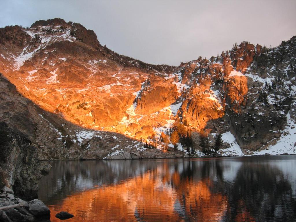
4 high lonesome. There are ragged peaks and torn rock faces all around us. Trees show signs of being ravaged by the heavy snows and violent storms. The summer vegetation is brown, crispy and crunchy as we walk through it. As we get close, patches of snow greet us. We are close now, and I let Chris go ahead so he can get the full on impact as we hike up a narrowing gully that ends with the lake at eye level. His exclamation brings a smile to my face; I know what he is seeing. The others clamber up to us, and stare at the beautiful cirque, rimmed by high granite, the lake set like a precious blue diamond in its center. There is really only one good spot for four, up above, and it is covered with 5 or 6 inches of snow. We stomp it kind of flat, and decide that instead of pitching tarps or tents, we will throw the tarp down and sleep out. The weather is stable, the view astounding, and we are thrilled to be where we are.

5 My special treat to my friends is that unbeknownst to them, I already know that this lake is also stuffed with trout. I don t know what this late season visit will do to the fishing, but I feel it s worth a try. We get the camp put together, brew up some warm drinks, and with the sun starting to set, I throw out that we should go spend the last hour trying to see if we can fool a few trout into hitting some spinners. Hiking down and around the lake a couple of hundred feet, three of us, Chris, Pete, and I find ourselves all casting out into the clear waters. As I reel in I get one hit, miss it, and then a couple of seconds later have another and its fish on! Pete and Chris are staring in disbelief when suddenly Pete yells, fish on! Within seconds, Chris yells, and his pole is bent over as well. A TRIPLE!!! Way cool! A minute or two later, the three of us, whooping and hollering, are standing together with some beautiful cutthroat trout in hand. Unhooking and releasing the fish, the guys are flying high with energy.

6 We fish for a while longer, catching a few more before the sun begins to set in earnest. I m standing with Brandon, and mention that this lake has a history of great alpenglow. Like throwing a switch, the heavens light up, and words can t describe the views we are treated to.
7

8 Brandon tells me he has been skunked fishing for the last two years. I point off to spot in the lake, I tell him to cast off over a nice ledge and drop off, knowing that it s a great ambush spot for fish. Wham, fish on and his skunk jinx is over!

9 We race the setting sun back around the lake and to our campsite. Now it is time to cook some hot food, re-hash the days hike, tell lies and generally enjoy the rest of the evening. The temps are dropping, but there is some cloud cover to offset any real chance of cold over the night. We cook, eat, brew up more hot drinks, and sit around until the chill finally drives us into our bags. The night is quite moderate, probably not even dropping much below freezing. I left an entire bottle of water out all night and it didn t even freeze around the lid. (I set it upside down; a trick that keeps the tops from freezing up for when you go to open them the next morning) There were meteor showers in the forecast, but the cloud cover effectively shut us out from the show. Maybe next time we will have a chance to take them in. We take a really leisurely wakeup call as the sun comes up, brewing up some breakfast, more hot drinks, before we finally pack up our packs and start out on the second part of our loop. I tell the guys that for all the cool views and beautiful spots we have seen so far, it is really the second part of the loop where the real peaks and big scenes are at. Pete has been up here before, but for Chris and Brandon, they look at me and just go are you serious? I love taking friends into the high country who have not had the opportunity to really see some of the unknown parts of the range; areas where the guide books don t really mention much about it.


10 Hiking down from the lake we can look out over the mountains, watching the morning sun begin to burn off the clouds, discovering the blue sky breaking out underneath. We catch the main trail once again, and begin hiking past a series of small lakes and ponds, finally scaling a short climb up to one of the landmark destinations in the Sawtooth Mountains; Sawtooth Lake. Sawtooth Lake is the largest alpine lake in the range, and it is backdropped to the south by Mt. Reagan. It sports the most photographed view in all of Idaho. I swear that every mountain calendar has this shot on it! Our route traverses the entire length of the lake, and then cuts across back to the west to catch

11 the Trail Creek trail system. The remnants of the early snow storm are in evidence as we trek across the windswept shores of Sawtooth Lake. The air is brisk, and we are all just enthralled with the views and the solitude. During the regular season, there might be people day hiking up to this lake. From the little town of Stanley, it is a very moderate 5 mile hike up to the lake. It is on everyone s to do list. Here in October, we have the entire lake and its beauty all to ourselves. What a treat this is! Our day is fast running by us. We continue down the canyon, fighting thru some crusty snow on the north faces, and dropping altitude as we hike down, down, down to the long awaited soak in the hot springs. The canyon had a major burn a few years back, and I had not been down this trail since the early 80 s. The stark contrast of burned trees and fall colors lend a strange pallet of colors as we hike. The hike down canyon is all of about 5 or 6 miles, and we stop for a brief lunch break in a sunlit meadow. Munching on smoked cheese, clams, and crackers, we are absolutely content with our hike through the region. The lure of the hot springs draws us out of our lunch stupor, and we hit the trail for the final mile or two. Along the South Fork of the Payette River just down from the trail head is a natural hot spring. With the late season river flowing slowly, and the water level low, would be engineers have stacked rocks and built pools along the rivers edge to trap the hot water and make for some great soaking pools. We change into our shorts, and slip into the hot water. The dust and grime from the trail washes off, and the heat melts our tired muscles. As lethargy begins to take over, we rouse ourselves from the water, towel off and head for home.

12 Back in civilization, I am still amazed that we were the only hikers in the entire area. I make a mental note to force myself to keep hiking into the fall months until the weather truly forces me to stop. This trip was a great reminder that with only a couple of extra pieces of clothing, and a little bigger sleeping bag, the trails are just as accessible, and even more fulfilling. Oh yeah, I m still needing to get back and check out that lake
The temperature is nice at this time of year, but water is already starting to be scarce.
 In March of 2003, Scott Morrison and I went backpacking in the Grand Canyon. The temperature is nice at this time of year, but water is already starting to be scarce. Another issue with this time of year
Three Sisters Wilderness Oct. 2009
 Three Sisters Wilderness Oct. 2009 I was in Bend, OR and had the whole day to travel back to Boise so I decided to take a hike to the popular Green Lakes and summit the South Sister in Three Sisters Wilderness.
Mount Daly a Most Prominent Peak via South Ridge
 Mount Daly a Most Prominent Peak via South Ridge Difficulty: Class 3 Exposure: Exposed in places along the ridge Summit Elevation: 13,305 Elevation Gain: 4100 from trailhead; 1800 from Capitol Lake camp
Etna winter expedition 1
 Etna winter expedition Etna, still active volcano. I ve been always tempted to climb it. I found a cheap flight ticket to Catania in February and I told myself why not in the winter! Two adventurous friends
Location: Height: Access: Distance: Elevation: Season: Difficulty: Lat/Long: Directions:
 Upper Eagle Falls Upper Eagle Falls (~20 ft.) is a short hike up from the roadside at the Eagle Falls picnic area. It is very difficult to get a parking spot here during the day, so it is recommended to
Date Name Trail Segment Conditions, Hazards and General Notes on Trails
 Trail Reports for Sawtooth NRA ***Unless otherwise reported-expect high creeks, snow levels at 7900 ft. and trees on trails. Due to high winds in the area, if trees were previously reported removed there
Date Name Trail Segment Conditions, Hazards and General Notes on Trails
 Trail Reports for Sawtooth NRA ***Unless otherwise reported-expect high creeks, snow levels at 7900 ft. and trees on trails. Due to high winds in the area, if trees were previously reported removed there
Itinerary Overview: What you will be doing Maroon Bells Alpine Backpacking 22 days
 Itinerary Overview: What you will be doing Maroon Bells Alpine Backpacking 22 days 0BCourse Description Welcome, you re in for an experience of a lifetime! Imagine hiking through rolling forests, sharing
Date Name Trail Segment Conditions, Hazards and General Notes on Trails
 Trail Reports for Sawtooth NRA ***Unless otherwise reported-expect high creeks, snow levels at 7900 ft. and trees on trails. Due to high winds in the area, if trees were previously reported removed there
Hiking Las Vegas.com
 Hike: Juniper Peak up and back Trailhead: Oak Creek Canyon marked Distance: 5.5 miles round trip Elevation gain: 2,200 feet Elevation peak: 6,109 feet Time: 4 to 5 hours - Up and back Difficulty: 3 Danger
Date Name Trail Segment Conditions, Hazards and General Notes on Trails
 Trail Reports for Sawtooth NRA ***Unless otherwise reported-expect high creeks, snow levels at 7500 ft. and trees on trails. Due to high winds in the area, if trees were previously reported removed there
Charnley Explorer June 24 - July 15, 2018 Bachsten Creek and the Charnley River. Second draft: 14 November 2017
 Charnley Explorer June 24 - July 15, 2018 Bachsten Creek and the Charnley River. Second draft: 14 November 2017 The best part of the original section one is now part of out Gibb Road Gorges trip. The dates
Non-motorized Trail Plan & Proposal. August 8, 2014
 Town of Star Valley Ranch, Wyoming and the Star Valley Ranch Association in partnership with the USDA Forest Service, Bridger-Teton National Forest, Greys River Ranger District Non-motorized Trail Plan
DAY 1 Ten miles out of Detroit, we cut off onto Whitewater Road 2243, a bumpy, gravel road that ends in a parking lot at the Whitewater Trailhead.
 1 WILDERNESS TREK VIII August 14-18, 2014 Greg and I chose to return to JEFFERSON PARK, a pristine, lake-filled, high mountain meadow on the North side of Oregon's own beautiful, Mt. Jefferson. In preparing
Itinerary Overview. Continental Divide Alpine Backpacking 22 days Ages Course Description
 Itinerary Overview Continental Divide Alpine Backpacking 22 days Ages 16-18 Course Description Welcome, you re in for an experience of a lifetime! Imagine hiking through rolling forests, sharing alpine
Twin Shaw Lakes. The girls at Upper Shaw Lake
 Twin Shaw Lakes 11 th Annual Daddy-daughter Adventure The girls at Upper Shaw Lake On Aug. 14-15, 2017 we (Brynn, Hailey, Kylie & Madilyn) decided to hike into Twin Shaw Lakes near McCall, ID. This was
Itinerary Overview. Maroon Bells Mountaineering 22-days. Course Description
 Itinerary Overview Maroon Bells Mountaineering 22-days Course Description Welcome, you re in for an experience of a lifetime! Imagine hiking through rolling forests, sharing alpine meadows with mountain
Trip Report: Backpack to East Boulder Lake in California Trinity Alps, July 7-9, 2016
 Trip Report: Backpack to East Boulder Lake in California Trinity Alps, July 7-9, 2016 Trekkers: Richard Hales, Aleece Townsend, Carol Mockridge, Rosalie Rybka, Elisabeth Zinser Day 1: Richard and Aleece
Drawing Conclusions and Making Inferences
 Drawing Conclusions and Making Inferences G TO THE STUDENT In this book, you will learn how to use the reading strategy called Drawing Conclusions and Making Inferences. With your teacher s help, you will
KILIMANJARO 2018 RUN & TREK February 28 March 12
 KILIMANJARO 2018 RUN & TREK February 28 March 12 Wednesday 28 Feb Depart USA to Kilimanjaro International Airport, Tanzania, Africa Thursday 01 March Arrive Kilimanjaro. Met upon arrival at the Kilimanjaro
Other Agencies and Organizations
 Daniel Boone National Forest 1700 Bypass Road WInchester, KY 40391 859-745-3100 Location Northern terminus is near Morehead, Kentucky. Southern terminus is located in the Big South Fork NRRA in Tennessee.
Quandary Peak East Ridge
 Quandary Peak East Ridge Difficulty: Class 1 / 2 June 28,2013 Exposure: Summit Elev.: 14,265 feet Trailhead Elev.: 10,850 feet Elevation Gain: 3,450 feet Roundtrip: 6.75 miles Hikers: Shan Stuart, Rick
Ernest Julius Erickson along with his brother, Frank Severin Erickson s first deer hun * Mt. Baldy, Oregon September 18 th 26th * 1917
 Ernest Julius Erickson along with his brother, Frank Severin Erickson s first deer hun * Mt. Baldy, Oregon September 18 th 26th * 1917 Ernest Julius Erickson s diary begins: My First Deer Hunt September
Itinerary Overview. Sawatch Range Mountaineering Ages days
 Itinerary Overview Sawatch Range Mountaineering Ages 14-16 22 days Course Description Welcome, you re in for an experience of a lifetime! Imagine hiking through rolling forests, sharing alpine meadows
Hiking Las Vegas.com
 Hike: Mt. Wilson via First Creek Canyon route Trailhead: First Creek marked Distance: 10 miles up and back Elevation gain: 3,400 feet Elevation of Peak: 7,070 feet Time: 7 to 9 hours (up and back) Difficulty:
Marten & Kelly Lakes 10 th Annual Daddy-daughter Backpacking Adventure
 Marten & Kelly Lakes 10 th Annual Daddy-daughter Backpacking Adventure I took my daughters to Marten and Kelly Lakes this year (mid July 2016) for our daddy-daughter overnighter. Marten Lake is west of
Date Name Trail Segment Conditions, Hazards and General Notes on Trails
 Trail Reports for Sawtooth NRA ***Unless otherwise reported-expect high creeks, snow levels at 7900 ft. and trees on trails. Due to high winds in the area, if trees were previously reported removed there
GOING CAMPING HAL AMES
 GOING CAMPING HAL AMES Robert did not like camping. He liked his house, his bed and his shower. When he was eight years old his father had taken him on their first, and last, camping trip together. It
Marangu 6 Days 5 Nights
 Marangu 6 Days 5 Nights Marangu Route is also known as the Coca Cola or tourist route. It is the easiest and shortest route to the summit. This is also the only route with the comforts of sleeping huts
Route Combo) Mt. Bierstadt - Bierstadt, Sawtooth, Evans
 Mt. Bierstadt - Bierstadt, Sawtooth, Evans") Climbing 14ers can be very dangerous, please read the Mountaineering Safety Page and make sure you have a map+compass and can use them effectively, without the help of electronic devices. Route Combo)
Climbing 14ers can be very dangerous, please read the Mountaineering Safety Page and make sure you have a map+compass and can use them effectively, without the help of electronic devices. Route Combo)
1. Use a rain cover for your backpack
 Hiking in the rain isn t everyone s cup of tea but I reckon it can actually be pretty fun. For a start, if you re on a track that takes you to a beautiful waterfall, then obviously it s going to be best
Attending: John Little, Brett Henderson, Kyle Musick, Annie Hollibaugh, J.C. Armoto, John Gilliland, Rusty, Roger Ault
 Do a 1 or 2 night trip in Deam Wilderness 15Feb2014 16Feb2014 Attending: John Little, Brett Henderson, Kyle Musick, Annie Hollibaugh, J.C. Armoto, John Gilliland, Rusty, Roger Ault Trip planned and led
TREK KILIMANJARO ABOUT THE CHALLENGE KILIMANJARO TREK - 11 DAY TANZANIA TREK RED 3
 TREK KILIMANJARO TANZANIA TREK RED 3 ABOUT THE CHALLENGE Climb the highest freestanding mountain in the world! Kilimanjaro is the highest mountain on the African continent at 5896m. Its snow-capped summit
Gear List. Snowshoeing Day Tours and Overnight Trips
 Snowshoeing Day Tours and Overnight Trips These are our recommendations for equipment on snowshoeing trips. You might have other equipment or clothes that are equally suitable but if you re not sure about
Little Grand Canyon near Pomona, Illinois
 Little Grand Canyon near Pomona, Illinois Below: View of the trail and the terrain created using the Map My Hike app Below: Summary of the hike created using the Map My Hike app Presented by: Jennifer
Itinerary Overview. Sangre de Cristo Alpine Backpacking 22 days Ages Course Description
 Itinerary Overview Sangre de Cristo Alpine Backpacking 22 days Ages 16-18 Course Description Welcome, you re in for an experience of a lifetime! Imagine hiking through rolling forests, sharing alpine meadows
The Storm. (looking at a photo of a boat) Very nice, Dad! Bye! See you at the picnic. My friends are waiting for me. I m late.
 Very nice, Dad! Bye! See you at the picnic. My friends are waiting for me. I m late.") The Storm Radio: It s another hot weekend in New York City, folks. The highs will be in the upper 90s. There is a chance of an afternoon thunderstorm. Stay cool if you can. (looking at a photo of a boat)
The Storm Radio: It s another hot weekend in New York City, folks. The highs will be in the upper 90s. There is a chance of an afternoon thunderstorm. Stay cool if you can. (looking at a photo of a boat)
5 DAYS MARANGU ROUTE ON KILIMANJARO
 5 DAYS MARANGU ROUTE ON KILIMANJARO Day 1: Drive to Kilimanjaro National Park Marangu Gate, Hike to Mandara Hut After breakfast and briefing, drive to the Kilimanjaro National Park Gate (about 1 hour),
Prostate Gathering in the Sierra High Country The Fourth Annual Jan Zlotnick Memorial August 19-24, 2018
 Prostate Gathering in the Sierra High Country The Fourth Annual Jan Zlotnick Memorial August 19-24, 2018 Thank you for your interest in the Fourth Annual Jan Zlotnick Memorial Gathering in the General
KUSHILAND Expeditions & Tour Safaris Ltd
 KILIMANJARO TREK MACHAME ROUTE TOUR CODE KMC 02 7 DAYS MACHAME ROUTE Kilimanjaro s Machame Route, often referred to as the Whiskey route, is more scenic and is longer than Marangu. The minimum duration
Mt. Lindsey in the Sangre de Cristos Aug 16, 2011
 Mt. Lindsey in the Sangre de Cristos Aug 16, 2011 Difficulty: Class 3 Summit Elevation: 14,042 feet Trailhead Elevation: 10,700 feet Elevation Gain: 3,500 feet but for us it was over 4000 Round-trip Length:
August 4-8, 2003 Collecting Cambrian Trilobites in the Bob Marshall Wilderness Area
 August 4-8, 2003 Collecting Cambrian Trilobites in the Bob Marshall Wilderness Area "The Bob". For the rest of my life those two words will conjure up images of pristine forests, beautiful scenery, and
CIEC 9 PEAKS AWARD SUPPLEMENT POSSIBLE ROUTES FOR THE 9 PEAKS AWARD TRIP
 CIEC 9 PEAKS AWARD SUPPLEMENT POSSIBLE ROUTES FOR THE 9 PEAKS AWARD TRIP As you plan your trip, be aware of 3 regulations in this wilderness: 1. Camp only in designated campsites. 2. No campfires allowed.
Itinerary Overview. Colorado San Juan Mountaineering 15-days
 Itinerary Overview Colorado San Juan Mountaineering 15-days Course Description Welcome, you re in for an experience of a lifetime! Imagine hiking through rolling forests, sharing alpine meadows with mountain
Marangu 5 Days 4 Nights
 Marangu 5 Days 4 Nights Marangu Route is also known as the Coca Cola or tourist route. It is the easiest and shortest route to the summit. This is also the only route with the comforts of sleeping huts
Prince Regent National Park
 Prince Regent National Park 23 rd June- 14 th July 2019 Garimbu Creek, Moran and Roe River Area Notes written by Cassie Newnes This area has something for everyone, magnificent scenery, stunning waterfalls,
LOWER SPRING CANYON - CAPITOL REEF
 LOWER SPRING CANYON - CAPITOL REEF Rating: Moderate Hike Length: 5-7 hours (10-11 miles) Gear: Standard Hiking Gear Maps: Fruita, UT; Twin Rocks, UT; Water: A filterable spring a bit over 1/2 way. Recommend
County Line trail - Miller Peak to Little Navaho
 County Line trail - Miller Peak to Little Navaho 7-17-2008 This hike features a portion of the County Line trail in the Teanaway that receives extremely little use despite offering a spectacular ridge-run
 Hike date Exertion Destination/ Leader(s) Description and Contact info Rating Hike Name 7/8-12/10 S+ Extreme Pleinair Sandy Compton Contact info: 208-290-1281 or sandy@scotchmanpeak.org This hike is nearly
Airtime: 3.3. Airtime: 1.1
 Sunday, October 22, 2017 Cobra flight #607, PIC #620, 2 landings National Canyon, Havasu Canyon, Grand Gulch Bar10: Airtime: 3.3 10:44 am Bar10: 2:04 pm Sunday, October 22, 2017 Cobra flight #608, PIC
Hiking 101. March 20, Andy Captain Blue Niekamp
 Hiking 101 March 20, 2018 Andy Captain Blue Niekamp Outdoor Adventure Connection Backpacking 101 Classes Overnight Backpacking Workshops Guided Backpacking Trips Programs & Presentations www.outdooradventureconnection.com
Arches of the. Sandflats Area. By Virginia Allen
 Arches of the Sandflats Area By Virginia Allen TABLE OF CONTENTS Introduction Dedication Road Log Arches 1. Perforated View Arch 2. Fee Booth Arch 3. Windsong Arch 4. Weird Arch 5. Resting Arch 6. Bike
Avalanches and the Mount Whitney Basin
 Avalanches and the Mount Whitney Basin 10 April 2006 by Bob Rockwell Prelude Avalanches are a fact of life in high mountains in winter, and we take courses to find out about them. We learn how to assess
Mt. Eolus and North Eolus
 Mt. Eolus and North Eolus Difficulty: Class 3 Exposure: Summit Elev.: Mt. Eolus: 14,083 feet N. Eolus: 14,039 feet Camp Elev.: 11,100 feet Elevation Gain: 3,200' starting at Chicago Basin 6,300' starting
Augerpoint Traverse - Pre Trip Information Package
 Thank you for choosing us as your guides for your trip on the Augerpoint Traverse. The following information is intended to help you prepare for your trip. We hope that it answers most of your questions.
Grizzly Peak A - East Ridge July 15, 2012
 Grizzly Peak A - East Ridge July 15, 2012 Difficulty: Difficult Class 2/Class 3 Upper Elevation: 13,995 feet Trailhead Elevation: 11,360 feet Elevation Gain: 3,000 feet Round-trip Length: 6.0 miles Trailhead:
Vatnajökull Glacier Expedition (IMG51)
") 2018 Vatnajökull Glacier Expedition (IMG51) Nine-Day Cross Country Ski-Tour with Pulkas / Sledges across the mighty Vatnajökull Glacier in Iceland - Expedition manual - Content overview Expedition overview
2018 Vatnajökull Glacier Expedition (IMG51) Nine-Day Cross Country Ski-Tour with Pulkas / Sledges across the mighty Vatnajökull Glacier in Iceland - Expedition manual - Content overview Expedition overview
2012 Squaw Butte Trail Warriors
 2012 Squaw Butte Trail Warriors Between June 1 st and September 30 th 2012 Squaw Butte supported nine trail maintenance projects. These projects covered a large section of south western Idaho, taking place
Alaska Backpacking Journey to Oz
 St. Elias Alpine Guides, LLC Wrangell-St. Elias National Park, Alaska (888) 933-5427 (907) 345-9048 www.steliasguides.com Alaska Backpacking Journey to Oz Traversing some of the most stunning terrain in
Kakadu Highlights No. 9: September 23 - October 6, 2018
 Kakadu Highlights No. 9: September 23 - October 6, 2018 Section 1: Barramundi Creek: September 23-26 We begin with a four to six hour, 350 kilometre drive from Darwin. The last 45 kilometres is on a 4WD
GOLDEN EARS PROVINCIAL PARK
 GOLDEN EARS PROVINCIAL PARK Trail Information as of October 10 th 2015 Do not underestimate the mountainous wilderness of Golden Ears Provincial Park. The combination of rugged terrain and rapidly changing
Rongai 6 Days 5 Nights
 Rongai 6 Days 5 Nights The Rongai Route is one of the easiest routes and the success rate is very high. The route starts on the North side of the mountain just South of the Kenyan border and is one of
Hike at Pico Blanco Labor Day Weekend!
 Hike at Pico Blanco Labor Day Weekend! The Pico Blanco Hymn Here among the trees majestic Pleasures you will find On the trails of Pico Blanco With your friends and mine Trail the Eagle ever onward This
Rogue Gorge (Mt. Stella) Roadless Area-- T30S R3E (primarily in portions of Sections 23, 26, 33, 34 & 35)
 Roadless Area-- T30S R3E (primarily in portions of Sections 23, 26, 33, 34 & 35)") Rogue Gorge (Mt. Stella) Roadless Area-- T30S R3E (primarily in portions of Sections 23, 26, 33, 34 & 35) Rogue River-Siskiyou National Forest--High Cascades Ranger District Upper, higher elevation trail
Rogue Gorge (Mt. Stella) Roadless Area-- T30S R3E (primarily in portions of Sections 23, 26, 33, 34 & 35) Rogue River-Siskiyou National Forest--High Cascades Ranger District Upper, higher elevation trail
PACIFICA DISTRICT 2010 KLONDIKE DERBY, Feb
 PACIFICA DISTRICT 2010 KLONDIKE DERBY, Feb. 26-28 Snow camping with Scouts is really cool! WHO?: All Boy Scouts WHAT?: The Klondike Derby is a youth-run winter camp out in the snow. (Yes, we actually hope
Machame 7 Days 6 Nights
 Machame 7 Days 6 Nights If Marangu is the Coca Cola route, then the Machame Route is the Whiskey route. It is the second most popular and one of the most scenic routes on the mountain. All climbers sleep
HB/VS-078 Üssers Barrhorn
 HB/VS-078 Üssers Barrhorn Paul HB9DST, August 23, 2015 Summary: This was a HB9SOTA club project, an activation of the highest summit in Europe you can hike up without ropes or other equipment. The headline
TREK THE ROCKIES ABOUT THE CHALLENGE TREK THE ROCKIES FOR HIGHLAND HOSPICE CANADA TREK DEMANDING
 TREK THE ROCKIES CANADA TREK DEMANDING ABOUT THE CHALLENGE The Canadian Rockies are justifiably world-famous for their magnificent scenery: the combination of impressive, jagged mountains, bright turquoise
Emily Rose Pazosʼ Most Creative Winning Entry
 Emily Rose Pazosʼ Most Creative Winning Entry I climbed out of the snowdrift and brushed myself off. Whew! That was a close one! I was lucky not to have hit a tree when the front ski tips of my snowmobile
Water falls on the south fork of Oh-be-Joyful Creek
 August 1-3, 2014, Friday Oh-be-joyful Creek 10,115, north 38 55 40, west 107 05 42 3.7 miles, 721 Raggeds Wilderness, Gunnison National Forest Gunnison County, Colorado Elaine met at my house at 7 am.
Campfire Ghost Stories
 Campfire Ghost Stories キャンプファイヤー怪談集 Andy Boon Read Smart Readers Level 1 Read Smart Readers graded readers graded readers Read Smart Readers 50 5 Read Japan Read the World 2 Read Japan Read the World Read
Kirigalpoththa Nature Trail Horton Plains National Park
 Kirigalpoththa Nature Trail Horton Plains National Park Trail Difficulty: Easy Moderate Strenuous Tough Trail Head: Horton Plains Visitor Centre Nearest Town: Pattipola Nearest City: Nanu-Oya Access to
MT KILIMANJARO TREK- LEMOSHO ROUTE
 #Trekking MT KILIMANJARO TREK- LEMOSHO ROUTE 10 Days 9 Nights Overview Take the challenging and less-travelled Lemosho route up to the highest peak in Africa, considered by many to be the most beautiful
Kindergarten-2nd. July 4-5, Joseph. Genesis 37-48; Jeremiah 29:11. God wants our obedience.
 Kindergarten-2nd July 4-5, 2015 Joseph Genesis 37-48; Jeremiah 29:11 God wants our obedience. Connect Time (15 minutes): Five minutes after the service begins, split kids into groups and begin their activity.
50miler.com Outing Resource Center on Facebook
 Snow Camping Shelters and Camps http://50miler.com Camp Lay Out Upon reaching a camp site the kitchen, latrine, cleanup sump, and snow caves are located. Paths are established between the different areas
Summer Camp!! 4th & 5th Grade Musical March 17, 2015
 Summer Camp 4th & 5th Grade Musical March 17, 2015 Summer Camp Summer Campin. Goin to Summer Camp (sing 3 times) All my friends from far and near. Are packing up a ton of gear. Now s the day we leave for
Mcleodganj - Triund (Himachal Pradesh) or Sumi's first proper Trek
 or Sumi's first proper Trek") Mcleodganj - Triund (Himachal Pradesh) or Sumi's first proper Trek We had already spent three days in Mcleodganj before we started our trek. We used that time to visit the Dalai lama and his beautiful
Mcleodganj - Triund (Himachal Pradesh) or Sumi's first proper Trek We had already spent three days in Mcleodganj before we started our trek. We used that time to visit the Dalai lama and his beautiful
Section 7: Pick Up Where You Left Off! S-Tree Road over the Todd Road
 2018 TRACE NOTES Helpful information for your adventure on Section 7 of the Hiker Challenge. Start Point S-Tree Rd. End Point Intersection Todd Rd. / Hale Ridge Rd. WEATHER DECISION Weather Alert!!!! Potential
Stein Valley Nlaka pamux Heritage Park
 Stein Valley Nlaka pamux Heritage Park - Trail Information Update and Winter Advisory November 2017 March 2018 Welcome to Stein Valley Nlaka pamux Heritage Park! **This trail update is to inform park users
but my body kind of shut down on me when I would get home from work it was all I could do to get a shower and eat alot of the time I would just
 September 5, 2008 My name is Rebecca Ann Frampton in 1999 I started hauling bio solids for Duffield Hauling Inc. about a month into the hauling I noticed that I began having head aches along with diarrhea
Trek2Kili P.O. Box 2112 Moshi TZ Whatsapp
 Trek2Kili P.O. Box 2112 Moshi TZ Whatsapp +255 673 360 trek2kili@gmail.com MT. KILIMANJARO RONGAI 6 DAY 5 NIGHT TREK Less crowded because of its remote location the route offers trekkers a unique wilderness
HIMALAYA MINDFUL LEADER. An opportunity for growth like no other.
 HIMALAYA MINDFUL LEADER An opportunity for growth like no other. FORWARD Hello! Thank you for expressing interest in our very special Mindful Leaders Himalaya retreat. We like to think of the term leadership
2 Night Rock to Rock. Travel to the heart of Australia
 2 Night Rock to Rock Travel to the heart of Australia Soak up the spirit of the land on this three-day journey into the Red Centre. Admire the incredible formations of Kings Canyon and Kata Tjuta (The
FROM JUTA TO ROSHKA via Chaukhi pass
 FROM JUTA TO ROSHKA via Chaukhi pass Duration: 1-2 days The hike can take one or two days, depending on how you plan it. I will focus on the 1-day version of the trek which takes 8-9 hours and starts in
Test Booklet. Subject: LA, Grade: 04 MSA 2009 Grade 4 Reading. Student name:
 Test Booklet Subject: LA, Grade: 04 MSA 2009 Grade 4 Reading Student name: Author: Maryland District: Maryland Released Tests Printed: Sunday September 02, 2012 1 We ran out of gas on the way to the theater,
50miler.com Outing Resource Center on Facebook
 Snow Camping Shelters and Camps http://50miler.com Camp Lay Out Upon reaching a reasonable camp site, leaders should find spots for the kitchen, latrine, cleanup sump, and snow caves. Paths are then established
7 DAYS RONGAI ROUTE ON KILIMANJARO ROUTE
 7 DAYS RONGAI ROUTE ON KILIMANJARO ROUTE Day 1: Drive to Kilimanjaro National Park Rongai Gate (Nale Moru), Hike to Simba Camp Drive to the attractive wooden village of Nale Moru (about 2 hours including
Frequently Asked questions
 Frequently Asked questions Where do we sleep? We hike from village to village. In the village we sleep in what is called a Tea House. It is a stone hut. For Tibet we stay in tents most of the days. How
Glacier National Park
 Glacier National Park West Glacier, MO Page 1 Page 3-6 Report Rough Draft Glacier National Park Glacier National Park is located in the northwest corner of Montana and extends into Canada. It is located
Mission. Purpose. Idaho Trails Association promotes the continued enjoyment of Idaho s hiking trails.
 The Idaho Trails Association (ITA) is a non-profit 501(c)3. Mission Idaho Trails Association promotes the continued enjoyment of Idaho s hiking trails. Purpose To facilitate the active enjoyment of Idaho
MOUNT KILIMANJARO TREK
 TANZANIA TREK EXTREME ABOUT THE CHALLENGE Climb the highest freestanding mountain in the world! Kilimanjaro is the highest mountain on the African continent at 5896m. Its snow-capped summit rises high
Iceland Trip. Monday April 16, 2018
 Iceland Trip Monday April 16, 2018 My parents picked us up and we went to the airport. We stopped in Seattle for a few hours and ate McDonalds and killed time before flying to Iceland. On the way to Iceland,
Good Night. John Newman (613)
") Good Night By John Newman WGA reg d (2011) johnnewman_136@hotmail.com (613)421-5720 FADE IN: INT. HOSPITAL - S ROOM - DAY PUSH IN toward a curtain drawn around a bed. HOSPITAL SOUNDS float in from the
Good Night By John Newman WGA reg d (2011) johnnewman_136@hotmail.com (613)421-5720 FADE IN: INT. HOSPITAL - S ROOM - DAY PUSH IN toward a curtain drawn around a bed. HOSPITAL SOUNDS float in from the
Waterproof Debris Shelter
 Bushcraft Video Series: David Styles, creator of 'Deep Nature Mentoring' presents Waterproof Debris Shelter Transcript Of Video 1. How Do We Make A Debris Shelter? Today we are going to learn about how
Course Description. North Cascades Alpine Backpacking for Veterans
 Course Overview Join other Veterans in the North Cascades Range of Washington for the opportunity to connect outside of the military in one of the most remote and beautiful alpine environments in the lower
playwinterpark.com Off The Beaten Path Hikes Hiking Recommendations for the Adventurous Hiker
 playwinterpark.com Off The Beaten Path Hikes Hiking Recommendations for the Adventurous Hiker Hike: Devil s Thumb (difficult) Length: 3.93 miles one-way Elevation: Trailhead 9609 Destination 12,236 Trailhead
Draft II - Trip Report by Kurt Wibbenmeyer
 Draft II - Trip Report by Kurt Wibbenmeyer COLORADO MOUNTAIN CLUB FAIRWEATHER MOUNTAIN EXPEDITION 2010 TEAM Rich McAdams Leader Mike Butyn Wayne Herrick Gerry Roach Bill Blazek Dave Covill Jim Rickard
Sky Ranch. SUMMER CAMPs. & conference centers. impacting lives forever
 sky ranch horn creek Retreats:The Bells &Whistles Sky Ranch SUMMER CAMPs & conference centers impacting lives forever www.skyranch.org 800.962.2267 standard activities Are included in your per-person rate,
Trail Report for KOKANEE GLACIER PROVINCIAL PARK and other Kootenay Lake Area parks (including west side of Purcell Wilderness Conservancy)
") Updated: October 23, 2017 Please call 250-354-6333 if you have new trail conditions to report. PARK AREA ROADS TRAILS ADDITIONAL INFORMATION Kokanee Creek SPECIAL NOTICE: Trail from Gibson Lake to drainage
Updated: October 23, 2017 Please call 250-354-6333 if you have new trail conditions to report. PARK AREA ROADS TRAILS ADDITIONAL INFORMATION Kokanee Creek SPECIAL NOTICE: Trail from Gibson Lake to drainage
Great Dismal Swamp Hiking/Canoeing
 Great Dismal Swamp Hiking/Canoeing Date: April 18/19 Location: Great Dismal Swamp Price: $25 Registration Deadline: April 10th, 10pm Pre trip Meeting: Tuesday, April 14, 9pm. TAP Room. Despite its name,