Twin Shaw Lakes. The girls at Upper Shaw Lake
|
|
|
- Melvin Wheeler
- 5 years ago
- Views:
Transcription
 first backpacking adventure with us. It was a lot of fun having her come and she was way excited. She ended up catching the largest fish measuring about 11 inches.")
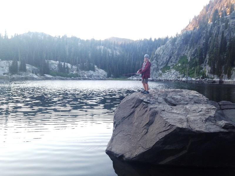
1 Twin Shaw Lakes 11 th Annual Daddy-daughter Adventure The girls at Upper Shaw Lake On Aug , 2017 we (Brynn, Hailey, Kylie & Madilyn) decided to hike into Twin Shaw Lakes near McCall, ID. This was Madilyn s (7) first backpacking adventure with us. It was a lot of fun having her come and she was way excited. She ended up catching the largest fish measuring about 11 inches. We just had a storm that cooled things down and cleared out all the smoke so

2 it was perfect timing. We had the place to ourselves since we left on a Monday. I wanted to avoid the traffic from the eclipse this weekend that is supposed to draw tons of people to the area. The hike is two miles round trip to the upper lake where we camped. It has a beautiful campsite near the outlet. The Huckleberries were just starting but the place will be full of them once they ripen. We spent most of our time fishing. We caught several Cutthroat mostly 10 and smaller. No big fish but plenty of action which works great for my daughters. It was neat to think that we may have caught fish planted by the Bingham s. Their son planted fish in this lake a few years ago for his Eagle Project. The girls usually swim but it was a little chilly for that on this particular day. They enjoyed reading in the hammock and we also came up with a few plays to perform for each other. We had a really good time! Campsite at Upper Shaw Lake I hiked with Cami and Jacie to Hyndman Peak last week for our daddy-daughter. I wanted to do something a little more challenging for them. It was a trip to remember! See article: I ve enjoyed many outings with my daughters over the years. It has become a tradition that we all look forward to every year. It s great to build these kind of relationships with my daughters.
 2008 Sawtooth Lake near Stanley (Kalyn & Cami) 2009 Shirts Lake near Cascade (Kalyn, Cami, Jacie, Brynn and")
3 Past Daddy-daughter Adventures: Jenny Lake near Idaho City (Kalyn & Cami) 2008 Sawtooth Lake near Stanley (Kalyn & Cami) 2009 Shirts Lake near Cascade (Kalyn, Cami, Jacie, Brynn and uncles and cousins) 2010 Norton Lakes near Sun Valley (Cami, Jacie, Brynn, Jeff, Jen & Julia) 2011 Iron Bog Lake near Arco & caving at Craters of the Moon National Monument (Kalyn, Cami, Jacie, Brynn, Hailey, Jeff, Jen & Julia) 2012 Snowslide Lake near McCall, canoeing Payette Lake & Parnell Beach (Cami, Jacie, Brynn, Hailey, Jeff, Jen, Julia, Ken & Emma) 2013 Boulder Lake near McCall & Rafting the NF Payette River (Cami, Jacie, Brynn, Hailey, Jeff, Jen, Julia, Ken & Emma) 2014 Curtis Lake near Cascade & Parnell Beach (Cami, Jacie, Brynn, Hailey, Kylie, Jeff, Jen & Julia) 2015 Ride horses in the Sawtooth Wilderness & bike Ketchum greenbelt (Kalyn and I) 2016 Marten Lake and Canoeing Bear Valley Creek (Darrin, Shelby, Lauren, Cami, Jacie, Brynn, Hailey, Kylie and I) Hyndman Peak near SunValley & Canoeing at Redfish Lake (Cami, Jacie and I) The girls at Lower Shaw Lake

4 Twin Shaw Lakes are east of McCall. They aren t as well-known as nearby Boulder and Louie Lakes. There is a road that heads off to the north from the road on the way to Boulder Lake. It s just over five miles on a decent road that is steep in a few places to reach the unmarked trailhead. Just before the main road dead ends at the summit, there is a road that you ll see to the left. Find parking anywhere once you get onto this road. Follow the road to the unmarked trailhead. The trail gains little elevation to the first lake. You ll follow a beautiful manmade stream for part of the hike. There is also a boggy area and small stream crossing on logs. You may have to do some cross-country early in the season to keep your feet dry. Look for huckleberries mid to late August. Once you reach the lake go left (north side of lake) and keep on the trail right next to the lake (water s edge in places). Once you reach the east end of the lake it s a short, steep trail to the upper lake. There is a nice campsite near the outlet on the south side. It s a very scenic lake with Pika calling from the cliffs. It s a great alpine lake hike for smaller children because of the distance. Hiking to the upper lake

5 Upper Shaw Lake

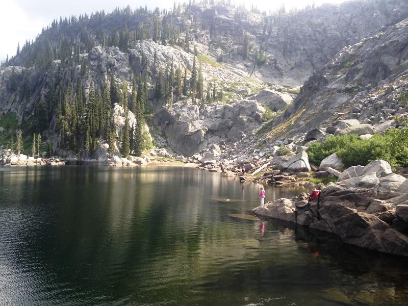
6 Fishing at Upper Shaw Lake


7 Fishing at upper Shaw Lake a possible fish planted from the Eagle Scout project

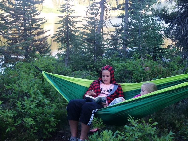
8 Chilling at Upper Shaw Lake

9 Fishing Upper Shaw Lake


10 Fishing at Upper Shaw Lake in the morning


11 Packing up and heading out (campsite above, Lower Shaw Lake trail below)


12 Swimming at Payette Lake at Ponderosa State park after the hike and after pizza in McCall
Marten & Kelly Lakes 10 th Annual Daddy-daughter Backpacking Adventure
 Marten & Kelly Lakes 10 th Annual Daddy-daughter Backpacking Adventure I took my daughters to Marten and Kelly Lakes this year (mid July 2016) for our daddy-daughter overnighter. Marten Lake is west of
2012 Squaw Butte Trail Warriors
 2012 Squaw Butte Trail Warriors Between June 1 st and September 30 th 2012 Squaw Butte supported nine trail maintenance projects. These projects covered a large section of south western Idaho, taking place
Location: Height: Access: Distance: Elevation: Season: Difficulty: Lat/Long: Directions:
 Upper Eagle Falls Upper Eagle Falls (~20 ft.) is a short hike up from the roadside at the Eagle Falls picnic area. It is very difficult to get a parking spot here during the day, so it is recommended to
Meadow Creek and Goat Creek pass through Goat Falls Ranch & Alpine Peak
 Henri W. LeMoyne 1346 Fillmore Street Post Office Box 5225 Phone: (208) 733-0874 Fax: (208) 733-8475 E-mail: henri@lemoynerealty.com Twin Falls, Idaho 83303-5225 Location: The Goat Falls Ranch is located
Date Name Trail Segment Conditions, Hazards and General Notes on Trails
 Trail Reports for Sawtooth NRA ***Unless otherwise reported-expect high creeks, snow levels at 7500 ft. and trees on trails. Due to high winds in the area, if trees were previously reported removed there
Date Name Trail Segment Conditions, Hazards and General Notes on Trails
 Trail Reports for Sawtooth NRA ***Unless otherwise reported-expect high creeks, snow levels at 7900 ft. and trees on trails. Due to high winds in the area, if trees were previously reported removed there
Date Name Trail Segment Conditions, Hazards and General Notes on Trails
 Trail Reports for Sawtooth NRA ***Unless otherwise reported-expect high creeks, snow levels at 7900 ft. and trees on trails. Due to high winds in the area, if trees were previously reported removed there
Driving Time: 3 hours (allow extra time for stops)
") Scenic Byways loop This journey takes visitors through the eastern edge of Mt. Rainier National Park and along two of Washington s most beloved scenic byways, the Chinook Byway and the White Pass Scenic
Scenic Byways loop This journey takes visitors through the eastern edge of Mt. Rainier National Park and along two of Washington s most beloved scenic byways, the Chinook Byway and the White Pass Scenic
Back Country Horsemen of Idaho. Squaw Butte Chapter Emmett Idaho. Summary of Activities February Celebration Park Snake River Birds of Prey
 Back Country Horsemen of Idaho Squaw Butte Chapter Emmett Idaho Summary of Activities 2016 Fun Rides & Membership Recruitment February Celebration Park Snake River Birds of Prey March Diamond Basin Silver
Trail Beginning Elevation: 7553 ft The Poison Creek Trailhead is located at the end of National Forest Road 646E (NF-646E).
.") West Mountain Trails Poison Creek Trail #134 Length: 2.9 miles (4.7 km) Difficulty Horseback: A good trail for the first time west mountain rider, some steep sections Hiking: Most Difficult USGS Maps:
West Mountain Trails Poison Creek Trail #134 Length: 2.9 miles (4.7 km) Difficulty Horseback: A good trail for the first time west mountain rider, some steep sections Hiking: Most Difficult USGS Maps:
Date Name Trail Segment Conditions, Hazards and General Notes on Trails
 Trail Reports for Sawtooth NRA ***Unless otherwise reported-expect high creeks, snow levels at 7900 ft. and trees on trails. Due to high winds in the area, if trees were previously reported removed there
Hiking Las Vegas.com
 Hike: Juniper Peak up and back Trailhead: Oak Creek Canyon marked Distance: 5.5 miles round trip Elevation gain: 2,200 feet Elevation peak: 6,109 feet Time: 4 to 5 hours - Up and back Difficulty: 3 Danger
Mission. Purpose. Idaho Trails Association promotes the continued enjoyment of Idaho s hiking trails.
 The Idaho Trails Association (ITA) is a non-profit 501(c)3. Mission Idaho Trails Association promotes the continued enjoyment of Idaho s hiking trails. Purpose To facilitate the active enjoyment of Idaho
Hiking Las Vegas.com
 Hike: Mt. Wilson via First Creek Canyon route Trailhead: First Creek marked Distance: 10 miles up and back Elevation gain: 3,400 feet Elevation of Peak: 7,070 feet Time: 7 to 9 hours (up and back) Difficulty:
Crystal Lake Area Trails
 Lake Area Trails Welcome to the Lake area of the Big Snowy Mountains! This island mountain range in central Montana features peaks reaching to 8,600 feet and long, high ridges from which vistas of the
Glacier National Park, MT
 Glacier National Park, MT July 28 Aug. 1, 2010 We decided to go to Glacier National Park for our family vacation this year. We had a great time seeing beautiful scenery and a variety of wildlife which
Three Sisters Wilderness Oct. 2009
 Three Sisters Wilderness Oct. 2009 I was in Bend, OR and had the whole day to travel back to Boise so I decided to take a hike to the popular Green Lakes and summit the South Sister in Three Sisters Wilderness.
Date Name Trail Segment Conditions, Hazards and General Notes on Trails
 Trail Reports for Sawtooth NRA ***Unless otherwise reported-expect high creeks, snow levels at 7900 ft. and trees on trails. Due to high winds in the area, if trees were previously reported removed there
Rocky Mountain Idaho s. Playground
 Rocky Mountain Idaho s Playground Sawtooth National Recreation Area is Ground Zero for outdoor recreation BOB & LYNN DIFLEY You can rent whatever floats your boat at Redfish Lake Marina paddle boats, kayaks,
Trailhead Ambassadors 2018 Latourell Falls: Alternative Hikes
 Trailhead Ambassadors 2018 Latourell Falls: Alternative Hikes General Note: The Historic Highway is closed from the Bridal Veil exit to its eastern end near Wyeth i.e., the Waterfall Alley section. The
Bradshaw Trails Series
 Bradshaw Trails Series Curtis James Troop 7014 Curtis.James@erau.edu My Motto: Never get lost! Hiking Rules Bradshaw Hiking Patch Series Hiking Tools Hiking Rules Hiking Merit Badge* Take five 10-mile
Utah/Arizona Borderlands
 Utah/Arizona Borderlands March 28 April 1, 2011 Spring break couldn t have come sooner. It s been a wet cold spring and a long winter here in Boise. The weather cooperated nicely in southern Utah & northern
Southwest Family Adventure. 7 Days
 Southwest Family Adventure 7 Days Southwest Family Adventure See three amazing National Parks Grand Canyon, Bryce, and Zion on this epic camping trip designed with families in mind. Every day offers magnificent
Hiking and kayaking/canoeing in the Boundary Waters
 Hiking and kayaking/canoeing in the Boundary Waters Boundary Waters, Minnesota May 24 th May 27 th, 2013 Comprehensive guide and packing list Trip at a glance: Enjoy your Memorial Day weekend in the wilderness
CONTRIBUTOR REWARDS PROGRAM
 CONTRIBUTOR REWARDS PROGRAM Here s how it works... Document + submit an adventure Earn Adventure Points (AP) when it s published Get rewards: awards, prizes, pro deals + earn cash Page Document + submit
GOLDEN EARS PROVINCIAL PARK
 GOLDEN EARS PROVINCIAL PARK Trail Information as of October 10 th 2015 Do not underestimate the mountainous wilderness of Golden Ears Provincial Park. The combination of rugged terrain and rapidly changing
SUMMER OF WOW! teens GIVE BACK VOLUNTEER ON A TEEN TRAIL CREW WILDERNESS ADVENTURES OVER 40 TRIPS AVAILABLE IN THE WHITE MOUNTAINS, MAINE AND NEW YORK
 OUTDOORS.ORG teens SUMMER OF WOW! GIVE BACK VOLUNTEER ON A TEEN TRAIL CREW EXPLORE AMC 2017 TEEN PROGRAMS WILDERNESS ADVENTURES OVER 40 TRIPS AVAILABLE IN THE WHITE MOUNTAINS, MAINE AND NEW YORK outdoors.org
Route #1) Mt. of the Holy Cross - North Ridge
 Mt. of the Holy Cross - North Ridge") Climbing 14ers can be very dangerous, please read the Mountaineering Safety Page and make sure you have a map+compass and can use them effectively, without the help of electronic devices. Route #1) Mt.
Climbing 14ers can be very dangerous, please read the Mountaineering Safety Page and make sure you have a map+compass and can use them effectively, without the help of electronic devices. Route #1) Mt.
The temperature is nice at this time of year, but water is already starting to be scarce.
 In March of 2003, Scott Morrison and I went backpacking in the Grand Canyon. The temperature is nice at this time of year, but water is already starting to be scarce. Another issue with this time of year
 Hike date Exertion Destination/ Leader(s) Description and Contact info Rating Hike Name 7/8-12/10 S+ Extreme Pleinair Sandy Compton Contact info: 208-290-1281 or sandy@scotchmanpeak.org This hike is nearly
Road and Trail Report 05/25/2015
 U.S.D.A. FOREST SERVICE KETCHUM RANGER DISTRICT 206 SUN VALLEY ROAD P.O. BOX 2356 KETCHUM, ID 83340 (208) 622-5371 Road and Trail Report 05/25/2015 Trail and Road conditions remain much the same as last
Activities. Why Asbury Hills? Register Now! Scholarships Available
 Matthew 17:20 Why Asbury Hills? I assure you that if you have faith the size of a mustard seed, you could say to this mountain, Go from here to there, and it will go. There will be nothing that you can
SAMPLE HIKING TRIPS Made with love by your CUHC Officers
 SAMPLE HIKING TRIPS Made with love by your CUHC Officers DISCLAIMER: Be sure to check trail conditions and weather before you hit the trail! IMPORTANT: Permits and wilderness regulations are frequently
CIEC 9 PEAKS AWARD SUPPLEMENT POSSIBLE ROUTES FOR THE 9 PEAKS AWARD TRIP
 CIEC 9 PEAKS AWARD SUPPLEMENT POSSIBLE ROUTES FOR THE 9 PEAKS AWARD TRIP As you plan your trip, be aware of 3 regulations in this wilderness: 1. Camp only in designated campsites. 2. No campfires allowed.
Adventures in the Rockies. 6 Days
 Adventures in the Rockies 6 Days Adventures in the Rockies On this action-filled adventure, experience two different sides to the Rockies on the western side, discover hidden gems that few visitors get
Oregon Section F - Page 1 WGS84 Zone 10T m
 08 N. 07 N. 06 N. Oregon Section F - Page 1 WGS84 Zone 10T LavaCampLakeTR - Lava Camp Lake Trail #4060 junction. - mi 1982.6-5287 ft LavaCampLake - Lava Camp Lake, campground, outhouse, 1/2 mile NE of
APPENDIX E. Current Outfitter-Guides
 APPENDIX E Current Outfitter-Guides Changes Between Draft and Final Environment Impact Statement Changed appendix letter from D to E. Updated outfitter-guide information. Made minor editorial and spelling
Trailhead Ambassadors 2018 Starvation Creek: Alternative Hikes
 Trailhead Ambassadors 2018 Starvation Creek: Alternative Hikes Starvation Creek Summary Near the Trailhead: o Starvation Creek Falls. Just a short walk to the east. o Loop trail to Cabin Creek Falls, Hole-in-the-Wall
The West Coast California Part 2
 The West Coast California Part 2 I have wanted to visit Yosemite National Park for years, always saying one day I ll get there. Well the time is here and I m going to spend 6 days exploring as much as
Pacific Crest Trail: Northern California By Jeffrey P. Schaffer READ ONLINE
 Pacific Crest Trail: Northern California By Jeffrey P. Schaffer READ ONLINE The Pacific Crest National Scenic Trail (PCT) is a 2,600-mile. While the PCT portion of this celebrated Northern California landmark
Work at Summer Camp How to choose which camp is right for you Rancho del Chaparral
 Work at Summer Camp Spend your summer in the beautiful mountains of New Mexico. Ride horses, canoe, go rock climbing, or dye your socks and get paid doing it. Obtain real world professional skills and
Oregon Section C - Page 1 WGS84 Zone 10T m
 00 N. 99 N. 98 N. 97 N. 96 N. 557000m Oregon Section C - 74.4 miles Start - Hwy 140, mile 1773.4 (near Fish Lake) End - Hwy 138, mile 1847.8 (near Cascade crest) Elevation Gain +8,111' Elevation Loss -7,145'
South Colony Basin Recreation Fee Proposal
 South Colony Basin Recreation Fee Proposal Purpose and Need for Collecting Fees in South Colony Basin: Forest Service appropriated funds have not been sufficient to maintain current recreational services
Route Combo) Mt. Bierstadt - Bierstadt, Sawtooth, Evans
 Mt. Bierstadt - Bierstadt, Sawtooth, Evans") Climbing 14ers can be very dangerous, please read the Mountaineering Safety Page and make sure you have a map+compass and can use them effectively, without the help of electronic devices. Route Combo)
Climbing 14ers can be very dangerous, please read the Mountaineering Safety Page and make sure you have a map+compass and can use them effectively, without the help of electronic devices. Route Combo)
playwinterpark.com Off The Beaten Path Hikes Hiking Recommendations for the Adventurous Hiker
 playwinterpark.com Off The Beaten Path Hikes Hiking Recommendations for the Adventurous Hiker Hike: Devil s Thumb (difficult) Length: 3.93 miles one-way Elevation: Trailhead 9609 Destination 12,236 Trailhead
Blue Ridge Hiking Club Hike List July- September 2016
 Blue Ridge Hiking Club Hike List July- September 2016 Saturday, July 2, Elk Knob: 3.8 mile round trip with 900 ft. gain in elevation. Spectacular views at the summit. The trails are mostly moderate, but
HIKING IN THE CANADIAN ROCKIES
 HIKING IN THE CANADIAN ROCKIES Distance Time Elevation y MORAINE LAKE TRAILS THE ROCKPILE 0.8 km (0.5 mi) 20 min 30 m (98 ft) Located adjacent to the Lodge, the short interpretive trail up the Rock Pile
PRIEST LAKE TRAILS. More information contact: Priest Lake Ranger District
 PRIEST LAKE TRAILS The varying terrain in the Priest Lake area ranges from river bottoms with an elevation of 2,600 to 7,500 ft. Valley bottoms, dense forests, meadows and occasional clearings and barren
We came with the expectation for our incoming freshman to get connected and that happened.
 Bible Camp offers a unique program designed to give groups the ultimate in adventure camping trips. The purpose is to impact lives for Christ. Our mission is to provide planning, outfitting, and guides
Oregon Equestrian Trails Mt. Hood Chapter
 Oregon Equestrian Trails Mt. Hood Chapter November 17, 2010 To: Michelle Lombardo, Mt. Hood National Forest From: Barb Adams, Oregon Equestrian Trail, Mt. Hood Chapter Re: Barlow and Hood River Ranger
Photographing Upper Peninsula Waterfalls
 Photographing Upper Peninsula Waterfalls Tod Poirier Freelance Photographer Photography is one of my passions. The following spread showcases several Upper Peninsula waterfalls. At times a single drop
MAROON BELLS SNOWMASS WILDERNESS - COLORADO LYC ADVENTURE TRIP ITINERARY 2018
 MAROON BELLS SNOWMASS WILDERNESS - COLORADO LYC ADVENTURE TRIP ITINERARY 2018 Tuesday, July 31, 2018 3:00 6:30pm Check-in & Dinner Preparations at accommodations 3:00 to 5:00pm Staff & Camper Arrival (Airport
U.S.D.A. FOREST SERVICE KETCHUM RANGER DISTRICT 206 SUN VALLEY ROAD P.O. BOX 2356 KETCHUM, ID (208)
") U.S.D.A. FOREST SERVICE KETCHUM RANGER DISTRICT 206 SUN VALLEY ROAD P.O. BOX 2356 KETCHUM, ID 83340 (208) 622-5371 Road and Trail Report 05/8/2015 More trails opened in Greenhorn this week. Only high elevation
U.S.D.A. FOREST SERVICE KETCHUM RANGER DISTRICT 206 SUN VALLEY ROAD P.O. BOX 2356 KETCHUM, ID 83340 (208) 622-5371 Road and Trail Report 05/8/2015 More trails opened in Greenhorn this week. Only high elevation
Road and Trail Report 04/02/2015
 U.S.D.A. FOREST SERVICE KETCHUM RANGER DISTRICT 206 SUN VALLEY ROAD P.O. BOX 2356 KETCHUM, ID 83340 (208) 622-5371 Road and Trail Report 04/02/2015 o Dry weather and a dwindling snowpack continue to bring
Route #2) Mt. Massive - Southwest Slopes
 Mt. Massive - Southwest Slopes") Route #2) Mt. Massive - Southwest Slopes Difficulty: Class 2 Ski: Advanced, D6 / R2 / III Exposure: Summit Elevation: Trailhead Elevation: Elevation Gain: Round-trip Length: Trailhead: County Sheriff:
Route #2) Mt. Massive - Southwest Slopes Difficulty: Class 2 Ski: Advanced, D6 / R2 / III Exposure: Summit Elevation: Trailhead Elevation: Elevation Gain: Round-trip Length: Trailhead: County Sheriff:
Juan de Fuca Trail Hiking/Backpacking Guide
 Juan de Fuca Trail Hiking/Backpacking Guide By Candice Camera Brief Background of the JDF Trail The Juan de Fuca Trail is a located in Juan de Fuca Provincial Park on Vancouver Island. The 47KM trail goes
Appendix D CURRENT OUTFITTER-GUIDES
 Appendix D CURRENT OUTFITTER-GUIDES The outfitters being studied in this analysis are described below. Refer to Figure 3.0-2 beginning on page 3-8 for a list of all outfitters operating within the analysis
Camp Geronimo Rainbow Trails
 Camp Geronimo Rainbow Trails With over 5,000 acres of surrounding national forest, the possibilities of getting out and seeing the wilderness are almost limitless. Camp Geronimo offers some of the greatest
throu Booth Hill Green Belt
 s k r a p s l l u b m u r T Explore gh Geocaching throu Booth Hill Green Belt This was originally a concept to try and preserve some of the land in our town, without hurting the developers that are creating
Durango. Durango Whitewater Park
 High Adventure Along Colorado s Million Dollar Highway Durango If you re looking for a multi-day trip of Jaw-dropping adventure in the Colorado mountains look no further! This guide outlays 4 days through
Oregon Section B - Page m
 Oregon Section B - Page 1 5 35000m 5 36000m 5 37000m 5 38000m 46 57000m 46 58000m Hwy5B - Interstate Highway 5 - mi 1716.4-4271 ft RD1717 - PCT departs paved Old Highway 99 - mi 1716.8-4357 ft PL1717 -
ABOUT THE PARKS NANTAHALA NATIONAL FOREST MOUNTAINS NATIONAL PARK CHEROKEE NATIONAL FOREST PISGAH NATIONAL FOREST GREAT SMOKY HIKING TRAILS
 ABOUT THE PARKS GREAT SMOKY MOUNTAINS NATIONAL PARK NANTAHALA NATIONAL FOREST CHEROKEE NATIONAL FOREST PISGAH NATIONAL FOREST GREAT SMOKY MOUNTAINS NATIONAL PARK Straddling the border between North Carolina
Rogue Gorge (Mt. Stella) Roadless Area-- T30S R3E (primarily in portions of Sections 23, 26, 33, 34 & 35)
 Roadless Area-- T30S R3E (primarily in portions of Sections 23, 26, 33, 34 & 35)") Rogue Gorge (Mt. Stella) Roadless Area-- T30S R3E (primarily in portions of Sections 23, 26, 33, 34 & 35) Rogue River-Siskiyou National Forest--High Cascades Ranger District Upper, higher elevation trail
Rogue Gorge (Mt. Stella) Roadless Area-- T30S R3E (primarily in portions of Sections 23, 26, 33, 34 & 35) Rogue River-Siskiyou National Forest--High Cascades Ranger District Upper, higher elevation trail
Choose Your Adventure!
 Choose Your Adventure! The Schuylkill Center s Summer Adventure Treks challenge pre-teens and teens to improve their outdoor knowledge and skills in a comfortable and supportive setting. Participants learn
YMCA Calgary Camp Chief Hector YMCA Summer Camp. KANANASKIN 12Y-13Y 6-day or 13-day Hector Lodge. 6-DAY KANANASKIN 12Y-13Y Hector Lodge
 KANANASKIN 12Y-13Y 6-day or 13-day Hector Lodge Kananaskin camps offer a time for learning, making friends, working as a team, and having fun outdoors! Campers who are Kananaskin age may choose to come
SDTrucksprings. Arkansas Off-roading/4x4 Guide Copyright 2015 We Specialize In:
 SDTrucksprings Arkansas Off-roading/4x4 Guide Copyright 2015 We Specialize In: Helper Springs Air Bags Leaf Springs Body Lift Kits Coil Springs Timbren Kits Hellwig Springs Lift Blocks And More! Visit
Figure 1 Understanding Map Contours
 Figure 1 Understanding Map Contours The light brown lines overprinted on topographic maps are called contour lines. They indicate the elevation above sea level of land features and thus permit you to view
GIFFORD PINCHOT NATIONAL FOREST
 GIFFORD PINCHOT NATIONAL FOREST 9341 Wright Meadow 93 Spencer Meadow Spencer Butte 4247' 30 30A 19 24 80 31C Lewis River Lower Falls 5 Quartz Creek 90 Taidnapam Falls Upper Falls 31 Spencer Peak 3861'
Non-motorized Trail Plan & Proposal. August 8, 2014
 Town of Star Valley Ranch, Wyoming and the Star Valley Ranch Association in partnership with the USDA Forest Service, Bridger-Teton National Forest, Greys River Ranger District Non-motorized Trail Plan
HORSEBACK RIDING. All rates are subject to service charges
 HORSEBACK RIDING The Local Loop Ride - A family-friendly 45-minutes to one hour ride around Dunton s east property. Perfect for children and adults who are new to riding. Easy terrain and beautiful views.
Large 2 Bedroom, Sleeps 8, Walk to Peak 9 & Downtown - Powderhorn
 Large 2 Bedroom, Sleeps 8, Walk to Peak 9 & Downtown - Powderhorn 503... Summary 2 BR 2 Full 1 Half Bath Condo - sleeps up to 10 Description Powderhorn 503 - a SkyRun Breckenridge Property Ski-in/walk-out
TREK THE ROCKIES ABOUT THE CHALLENGE TREK THE ROCKIES FOR HIGHLAND HOSPICE CANADA TREK DEMANDING
 TREK THE ROCKIES CANADA TREK DEMANDING ABOUT THE CHALLENGE The Canadian Rockies are justifiably world-famous for their magnificent scenery: the combination of impressive, jagged mountains, bright turquoise
Downtown, Remodeled, Mountain Views, Walk To Main Street - Summit View...
 Downtown, Remodeled, Mountain Views, Walk To Main Street - Summit View... Summary 4 BR 3 Bath Townhome - sleeps up to 12 Description Summit View Chalet - a SkyRun Breckenridge Property - Large home close
L U N C H C R E E K T R A I L GLACIER NATIONAL PARK
 D I R T I N M Y S H O E S L U N C H C R E E K T R A I L GLACIER NATIONAL PARK Lunch Creek "Secret" Hike This short hike on the Lunch Creek Trail will knock your socks off! It's the perfect mix of length,
California Section I - Page 1. California Section I miles. WACS0948 may be the last. End - Hwy 108 [Sonora Pass], mile 1016.
![California Section I - Page 1. California Section I miles. WACS0948 may be the last. End - Hwy 108 [Sonora Pass], mile 1016.](/thumbs/89/98421036.jpg "California Section I - Page 1. California Section I miles. WACS0948 may be the last. End - Hwy 108 [Sonora Pass], mile 1016.") California Section I - Page 1 2 8m 2 8m 2 0m 2 91000m 2 92000m 294000m 2 8m 41 9m 41 9m California Section I - 74.4 miles 948 may be the last water northbound until McCabe Start - Hwy 120 [Tuolumne Meadow],
California Section I - Page 1 2 8m 2 8m 2 0m 2 91000m 2 92000m 294000m 2 8m 41 9m 41 9m California Section I - 74.4 miles 948 may be the last water northbound until McCabe Start - Hwy 120 [Tuolumne Meadow],
beach. Make the ford and follow the trail out to the junction with Red Creek Tr in an open grassy area.
 Description: This is a moderate to slightly strenuous 22.8 mile backpack (add 2.6 miles if you do the packless out and back to the Lion s Head) that will have you exploring nearly every thing that is The
Utah Canyon Country Arches and Canyonlands National Parks March 25-31, 2012
 Utah Canyon Country Arches and Canyonlands National Parks March 25-31, 2012 We took advantage of the last week of our national parks pass and headed to the Moab area and visited my parents and family for
Junior Ranger Guide. Recommended for Ages Photo Charlie Johnson
 Junior Ranger Guide Recommended for Ages 7-12 Photo Charlie Johnson 1 Hi! I m Barry the Bear and I m excited to help you become a Larimer County Junior Ranger! Rangers keep parks and open spaces safe for
Looking back across Emerald Lake at Wapta Mountain (on the left) and Mount Burgess (on the right):
 and Mount Burgess (on the right):") YOHO LAKE FROM EMERALD LAKE, YOHO NATIONAL PARK, BRITISH COLUMBIA, CANADA We decided to hike to Yoho Lake from Emerald Lake even though the distance is longer than the trail from Takakkaw Falls (about
YOHO LAKE FROM EMERALD LAKE, YOHO NATIONAL PARK, BRITISH COLUMBIA, CANADA We decided to hike to Yoho Lake from Emerald Lake even though the distance is longer than the trail from Takakkaw Falls (about
Kuruwita Erathna Trail to Sri Pada (Adam s Peak)
") Kuruwita Erathna Trail to Sri Pada (Adam s Peak) Trail Difficulty: Easy Moderate Strenuous Tough Trail Head: Adevikanda, Erathna (near entrance to mini-hydro power plant) Nearest Town: Erathna Nearest
Kuruwita Erathna Trail to Sri Pada (Adam s Peak) Trail Difficulty: Easy Moderate Strenuous Tough Trail Head: Adevikanda, Erathna (near entrance to mini-hydro power plant) Nearest Town: Erathna Nearest
Flat Rock River YMCA Camp Family Guide 2019
 Flat Rock River YMCA Camp Family Guide 2019 6981 W. County Road 650 N. St. Paul, IN 47272 flatrockymca.org 765-525-6730 WELCOME Making Time for What Matters Most Flat Rock River YMCA Camp believes everyone
Royal Gorge Far Out Trail to Le Point
 Royal Gorge Far Out Trail to Le Point Direction to trailhead: From East Ridge Campground: Drive west from Canon City on US 50 to County Road 3A, the entrance road to the Royal Gorge Park. Turn left onto
LIST OF LOCAL SIGHTS AND RECREATION
 LIST OF LOCAL SIGHTS AND RECREATION Pictures of Klamath Falls - http://members.spree.com/sip/sunnidaze/me/kfalls.html One of the local members of Kingsley Field took some pictures of the local area in
Southern Utah University Hike Brochure
 Southern Utah University Hike Brochure Taylor Creek Trail Twenty minutes from Cedar City Red Hollow An hour and a half from Cedar City Fees: Entrance fee to Kolb Canyon Length: 5 miles round trip Length:
Outdoor Activity Leadership Program Overview
 Outdoor Activity Leadership Program Overview Getting outside, enjoying nature, and challenging ourselves are some of the best parts of the Guiding experience and are a central part of the Girl Guide philosophy
THE REGION LAKE SUPERIOR THE GITCHI-GAMI TRAIL & THE NORTH SHORE
 LAKE SUPERIOR THE GITCHI-GAMI TRAIL & THE NORTH SHORE 7 LAKE SUPERIOR: Water covers 70% of the earth s surface area, but only 3% of it is freshwater. Saltwater makes up 97% of the earth s water supply.
1. Waterfall Gully Mt Lofty. 5 Of the Best Hikes in Adelaide
 Adelaide is a beautiful city, and one of the most incredible things about Adelaide is the quality of bushwalking available on the suburban fringe. It is surrounded by the Mt Lofty Ranges, and much of the
YMCA Calgary Camp Chief Hector YMCA Summer Camp
 KANANASKIN 12 AND 13Y HECTOR LODGE PROGRAM OPTIONS 12Y Hike 12/13Y Horse 12/13Y Mountain Arts *NEW* 13Y Hike 13Y Canoe Campers in the 12 and 13Y Programs experience a wide variety of camp activities. Through
Canada Rocky Mountain Adventure Into the Wild
 Canada Rocky Mountain Adventure Into the Wild Itinerary Canada Rocky Mountain Adventure Into the Wild 15 days / 14 nights Calgary Kananaskis Country Spray Lake Canmore Banff Lake Louise Moraine Lake Jasper
Cozy 2 Bedroom Condo, Short Walk To Town! Forest Haus 212 by SkyRun
 Cozy 2 Bedroom Condo, Short Walk To Town! Forest Haus 212 by SkyRun Summary 2 BR 1 Bath Condo - sleeps up to 6 Description Forest Haus 212 - a SkyRun Breckenridge Property Short walk to downtown Breckenridge
Hike at Pico Blanco Labor Day Weekend!
 Hike at Pico Blanco Labor Day Weekend! The Pico Blanco Hymn Here among the trees majestic Pleasures you will find On the trails of Pico Blanco With your friends and mine Trail the Eagle ever onward This
The gorges of Mohican Park in Ohio create a hiker's paradise Sunday, May 22, 2011 By Bob Downing, Akron Beacon Journal
 Pittsburgh Post-Gazette The gorges of Mohican Park in Ohio create a hiker's paradise Sunday, May 22, 2011 By Bob Downing, Akron Beacon Journal Bob Downing Big Lyons Falls drops 80 feet into a shady U-shaped
Logan Canyon Hiking Trail Guide
 C a c h e V a l l e y V i s i t o r s B u r e a u Logan Canyon Hiking Trail Guide Monique Beeley Legend Trail Location Guide WASATCH CACHE NATIONAL FOREST WILDERNESS PAVED WATER TRAILHEAD 9 Logan River
List of Challenges. Draw a Map of Your Hike
 List of Challenges Junior Ranger Wildlife Adventures Draw a Map of Your Hike Explore Pella Crossing Hey kids! Do you love animals as much as the Boulder County Park Rangers? Join us on Saturday, June 2
October in the Sawtooths
 October in the Sawtooths By the time hunting season rolls around, the high country is typically cold, often white, and pretty empty. Lots of hunting camps with big canvas wall tents; complete with wood
Take Me. Outside!!! C.R.X C.R.X. Registration Begins April 30, 2018 ~ Guarantee your spot!
 Caribou Rec. Xtreme Take Me. Outside!!! C.R.X. 2018 C.R.X. Registration Begins April 30, 2018 ~ Guarantee your spot! Allagash, Baxter State Park, Backpacking, Kayaking, Mountain Biking, Camping, Swimming
White Mountain Wilderness Trails
 The area in which these hikes are located is rugged high mountain country along the Mogollon Rim. This famous eastwest escarpment separates Arizona's high plateau from the basin and range below. These
Tiger Mountain State Forest:
 98 60 hikes within 60 miles: SEATTLE 20 Tiger Mountain State Forest: West Tiger Mountain Three Loop i KEY AT-A-GLANCE INFORMATION Length: 5.1 miles round-trip Configuration: Loop Difficulty: Moderate difficult
Trail Details Location
 Blind Blue Ribbon Centennial Conditions: Forest trail, with duckboards, and rope railing. Need: Blind trail activity bag, available in the camp office. None Availability: Open all seasons. Use the outdoor
! Kilimanjaro Expedition
 ! Kilimanjaro Expedition Tanzania 2016 Climb Only: $4,350 (land costs) Feb 4-12; June 12-20; July 10-18; Aug 6-14; Sept 11-19; Dec 4-12 2016 Climb & Safari: $5,850 (land costs) Feb 4-15; June 12-23; July