Oak Ridges Corridor Park East Management Plan
|
|
|
- Theodore Martin
- 5 years ago
- Views:
Transcription
1 Oak Ridges Corridor Park East Management Plan August 2011 Prepared by: Oak Ridges Corridor Park East Technical Steering Committee Oak Ridges Corridor Park East Public Advisory Committee Conservation Lands Group, Toronto and Region Conservation
2 Table of Contents List of Maps... iv List of Figures... iv List of Tables... iv Executive Summary Introduction and Process Introduction Plan Process Endorsement of the Management Plan Plan Review and Amendment Vision and Values Towards a Living City Region TRCA s Terrestrial Natural Heritage System Strategy Humber River Watershed Plan: Pathways to a Healthy Humber (2008) Rouge River Watershed Plan: Towards a Healthy and Sustainable Future (2007) Oak Ridges Corridor Park Management Plan (2006) Vision and Values Existing Environment Terrestrial Natural Heritage Natural Heritage System Vegetation Community Flora Fauna Aquatic Resources Human Heritage Archaeology Settlement Recent History Existing Use Management Zones Determining the Management Zones Defining and Mapping the Management Zones Management Recommendations i
3 5.1 Ecological Natural Heritage Protection Restoration Cultural Social Trails Site Securement Community Outreach and Engagement Economic Integration Trails Trail System Primary Trail Secondary Trail Permitted Uses Trailheads Trail Management Decommissioning Existing Trails Hazard Tree Management Signs Trail Identification and Information Directional Regulatory Interpretive Emergency Access Trail Plan Implementation Summary of Recommendations, Implementation Schedule and Budget Summary of Recommendations Implementation Schedule Partnership Opportunities Stewardship Committee Agency and Municipal Stewardship Private Land Stewardship Public Use Safety and Security Endorsement and Maintenance of the Management Plan ii
4 7.10 Plan Review and Amendment Bibliography Appendices Appendix A: Natural Heritage Maps Appendix B: Management Zone Planning Maps Appendix C: Restoration Maps Appendix D: Watershed Plan Targets Appendix E: Trail Design and Management Trail Design Standards Trail Impacts and Mitigation Techniques Trail Construction Trail Management Maintenance Monitoring and Management Systems Appendix F: Site Securement and Protection Plan Appendix G: Summary of Management Recommendations and Actions Appendix H: Detailed Implementation Plan iii
5 List of Maps Map 1.1: Context, Oak Ridges Corridor Park East... 8 Map 1.2: Future Surrounding Land Use, Oak Ridges Corridor Park East... 9 Map 3.1: York County, Whitchurch Township Map 4.1: Current Management Zones, Oak Ridges Corridor Park East Map 6.1: Trail Plan, Oak Ridges Corridor Park East Map A.1: Habitat Patch Size with Fauna, Oak Ridges Corridor Park East Map A.2: Interior Forest, Oak Ridges Corridor Park East Map A.3: Matrix and Flora Sensitivity, Oak Ridges Corridor Park East Map A.4: Matrix and Fauna Sensitivity, Oak Ridges Corridor Park East Map A.5: Habitat Patch Quality, Oak Ridges Corridor Park East Map A.6: Vegetation Communities and their Associated Local Ranks, Oak Ridges Corridor Park East Map A.7: Flora Species of Concern, Oak Ridges Corridor Park East Map A.8: Fauna Species of Concern, Oak Ridges Corridor Park East Map B.1: Existing Conditions Scenario, Oak Ridges Corridor Park East Map B.2: Build Out Scenario, Oak Ridges Corridor Park East Map B.3: Build Out and Restoration Scenario, Oak Ridges Corridor Park East Map B.4: Impact Analysis, Oak Ridges Corridor Park East Map C.1: Proposed Planting Areas, Oak Ridges Corridor Park East Map C.2: Habitat Opportunities, Oak Ridges Corridor Park East Map F.1: Oak Ridges Corridor Park East Site Securement Plan, Access Points List of Figures Figure 3.1: Habitat Patch Size Scores, Oak Ridges Corridor Park East Figure 4.1: Percentage of Current Management Zone Designations, Oak Ridges Corridor Park East Figure 4.2: Percentage of Future Management Zone Designations, Oak Ridges Corridor Park East Figure E.1: Trail Design Standards for Hiking Trails List of Tables Table 4.1: Table 4.2: Table D.1: Table D.2: Table E.1: Table F.1: Management Zone Definitions Management Zone Resources Uses Humber River Watershed Plan: Selected Targets and Oak Ridges Corridor Park East Management Plan Contributions Rouge River Watershed Plan: Selected Targets and Oak Ridges Corridor Park East Management Plan Contributions Definitions of Basic Trail Components Oak Ridges Corridor Park East Site Securement and Protection Plan, Access Points and Status iv
6 Executive Summary The Oak Ridges Moraine is one of Ontario s most significant landforms, stretching 160km and providing clean, safe drinking water to over a quarter of a million people. It also provides an essential natural corridor for hundreds of plant and wildlife species that call the Oak Ridges Moraine home. As part of its strategy to protect these environmentally sensitive lands, the Province of Ontario reached an agreement in the early part of this decade to create the Oak Ridges Corridor Park, a 428 hectares nature sanctuary that stretches from Bathurst Street to Bayview Avenue and includes a 5km spine trail. The Oak Ridges Corridor Park is enhanced by over 175 hectares of greenspace owned by the Toronto and Region Conservation Authority (TRCA) to the east of Bayview Avenue. Referred to as the Oak Ridges Corridor Park East lands (ORCPE), this property is dominated by forests and wetlands, and consists of many unique and sensitive natural areas. The primary goal of the management plan for ORCPE is to protect the high quality habitats and sensitive plants and wildlife found on the lands. Important in their own right, these natural features also contribute to the larger Jefferson Forest complex, to the protection of the headwaters of two watersheds, and to the entire Oak Ridges Moraine landform. Within the site are over 80 vegetation communities, 471 plant species, and 81 wildlife species. However, this site is under pressure. The population of Richmond Hill is projected to increase from approximately 170,000 in 2006 to over 240,000 in Rising urban populations will place increased pressure on the lands in a variety of ways, including increasing demand for access and recreation. Pending development to the east and west has the potential to impact the hydrology of the site, on which many of the natural systems depend. These potential impacts underscore the need for careful planning, responsible management, and above all, restoration of the disturbed lands. Only by increasing the natural cover on these lands can the potential impacts be mitigated and the integrity of the natural systems increased and protected. This management plan lays out a series of management recommendations and actions that seek to protect the natural heritage system while also providing for enjoyable nature-based recreation for visitors. Chapter one provides an introduction to the site, and lays out the process that was used to develop the management plan. The second chapter provides context for the management plan by exploring the visions of guiding documents such as TRCA s Towards a Living City Region, as well as the watershed plans for the Rouge River and Humber River watersheds. It ends by laying out a series of value statements that were developed in consultation with the technical and advisory committees, and guided the development of this plan. The existing natural and human heritage, as well as land use conditions, is summarized in chapter three. This information is provided in more detail in the Oak Ridges Moraine Conservation Plan Management Plan Background Report, which details the current 1
7 knowledge about ORCPE and evaluates the property based on relevant plans and policies, existing resource inventories, environment conditions, site limitations and opportunities. The background report was the primary resource used to determine the management zones. The management zones, discussed in chapter four, are intended to guide how the property is managed where ecological features must be protected, where public use and trails will be permitted, and where restoration efforts will be focused. For the ORCPE, large sections of the property are zoned as nature reserve, in support of the goal of protecting the natural systems. Public use in the form of trails is provided in the natural environment zones, which are laid out as corridors running throughout the property. Primary restoration zones are designated throughout the properties where there has been significant damage in the past from motorized vehicles, or where agricultural fields have been targeted for restoration. In the future, the majority of those primary restoration zones will be converted to nature reserve zones. Chapter five contains the management recommendations and actions, laid out in the same categories as the value statements from chapter two: ecological, cultural, social and economic. The ecological section contains detailed recommendations for protecting the natural features of the site, including implementing a management program for terrestrial non-native invasive plants, carrying out strategic restoration projects, and protecting the site from hydrologic changes and other land use impacts. The cultural section highlights the need to conduct careful assessment work to document and protect cultural heritage features on the site. The social section of chapter five discusses the importance of stewardship and community engagement to the future health of this natural area. Key recommendations include the development of a trail system, working with community members to develop a stewardship committee or Friends of group, and continued outreach through newsletters and other materials. This section also outlines recommendations for site securement, and builds on the excellent work that has been done in this regard over the last three years. The economic section discusses the importance of forming partnerships with municipal partners and local community organizations in order to successfully secure funding and support to implement the management plan. Lastly, recommendations for integration with the Oak Ridges Corridor Park are discussed, as it is the intent of TRCA and the Province of Ontario to manage these two properties cohesively. Integration will be key to the successful and efficient management of these lands, and will include key elements such as trail planning, signage, and operations. To further the successful integration of the two properties, it is also being proposed that the name Oak Ridges Corridor Conservation Reserve eventually be applied to both the ORCPE lands and the Oak Ridges Corridor Park lands, thus uniting both properties under a single name. Some key management recommendations include: Restore damaged areas and agricultural fields to forest, wetland and meadow habitat Establish a sustainable trail system, featuring primary and secondary trails, that will protect the natural system while providing nature-based recreation opportunities 2
8 Engage local residents and community groups in a stewardship program to care for the Oak Ridges Corridor Park and Oak Ridges Corridor Park East lands Maintain the fields south of Bethesda Sideroad for active agriculture or similar use (e.g. community gardens) Conduct regular inventory and monitoring of the flora, fauna and overall condition of both the aquatic and terrestrial ecosystems Integrate management of Oak Ridges Corridor Park East and Oak Ridges Corridor Park, and unite both properties under a single new name, Oak Ridges Corridor Conservation Reserve The trail system is discussed in more detail in chapter six, which outlines a trail plan and trail development recommendations. The trail plan will consist of a primary trail that will be an extension of the spine trail in the main Oak Ridges Corridor Park and which will form a part of the inter-regional Oak Ridges Trail. The primary trail, which will run northsouth and east-west through the property, will be enhanced by a series of secondary trails connecting to the planned communities, as well as providing recreational loops to allow visitors to enjoy the many scenic vistas on the property. Primary and secondary trailheads will be provided at various points around the property, including parking lots on Bethesda Sideroad and Stouffville Sideroad. Lastly, chapter seven prioritizes all the management recommendations and actions together and lays out an implementation schedule and preliminary budget. The Oak Ridges Corridor Park East Management Plan seeks to protect the critically important natural features on the site, while also engaging the public by providing an enjoyable trail system. The plan was developed through extensive consultation with partners, community groups, stakeholders, and the public, and has been greatly strengthened by their input and expertise. TRCA looks forward to working with all of these groups in the future towards our shared goal of the successful stewardship of this valuable greenspace. 3
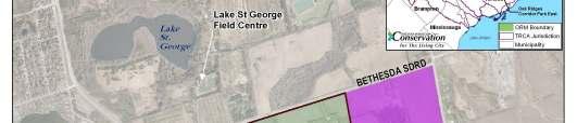
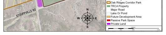
9 1 Introduction and Process 1.1 Introduction The Oak Ridges Moraine is one of Ontario s most significant landforms, stretching 160 km from the Trent River in the east to the Niagara Escarpment in the west. As the source of 65 major streams and rivers, it provides clean, safe drinking water to over a quarter of a million people. It is home to hundreds of plant and animal species. As part of its strategy to protect environmentally sensitive lands on the Oak Ridges Moraine, the Province of Ontario reached an agreement to exchange lands it owned in North Pickering for privately owned lands in the Town of Richmond Hill in These lands, now called the Oak Ridges Corridor Park, ensure the provision of an east-west natural corridor at the narrowest pinch point on the Oak Ridges Moraine. A management plan was prepared for the park in In addition to the 428 hectares that form the main Oak Ridges Corridor Park, the Toronto and Region Conservation Authority (TRCA), owns approximately 175 hectares of greenspace lands east of Bayview Avenue. Referred to as the Oak Ridges Corridor Park East (ORCPE) property, these lands are dominated by natural cover and consist of many unique and sensitive natural features. The ORCPE lands were acquired between 2001 and 2009 from eight different owners. Four of these transactions were from developers for nominal consideration of $2.00 and the remaining properties were purchased at market value. As part of the Bayview Oakridges Estates Inc. purchase in 2006, funds were set aside for the development of a management plan. It is the intent of TRCA and the Province that the main Oak Ridges Corridor Park and the ORCPE lands be managed cohesively, while ensuring that the unique natural features of the ORCPE lands be documented and protected. To that end, TRCA has undertaken to develop this management plan specific to the ORCPE lands. The Oak Ridges Corridor Park East Management Plan provides direction to protect, conserve and restore the valuable ecological features and functions of the site, while guiding the current and potential future public uses of the area. The plan recognizes that engaging area residents early on and working with them to create a stewardship ethic in their communities is essential to the future health of any natural area. Development of a trail plan that will allow residents to enjoy and appreciate this natural area is a key component of the management plan. The ORCPE property straddles the boundary between the Humber River and Rouge River watersheds (see map 1.1). It is located in the Town of Richmond Hill, in the Region of York. Its boundaries are Bethesda Sideroad to the north and Stouffville Road to the south and it is located between Bayview Avenue and Leslie Street to the west and east. The majority of the property within the study area is owned by the Toronto and Region Conservation Authority, with the exception of two parcels owned by the Province of 4
10 Ontario (see map 1.1). The two parcels owned by the Province were addressed in the management plan developed for the Oak Ridges Corridor Park in 2006; however, for the purposes of management zones, management recommendations and trail planning, they will be included within the study area for this management plan. For the sake of simplicity, in this management plan all parcels, regardless of ownership, will be referred to as ORCPE. ORCPE consists of forest and successional forest areas, wetlands and meadows. The site is noteworthy for the large forest complex it contributes to, which includes the Jefferson Forest Area of Natural and Scientific Interest to the south of the property, and for contributing a diversity of high quality habitats to the ecosystem functions of the headwater region. Of particular note are the high quality wetlands on the site that provide critical habitat for amphibians. The site also provides important forest habitat in the middle of the Oak Ridges Moraine, where forest cover is lacking. In addition to the extensive natural areas on the property, there are also a number of fields that are currently leased for active agricultural use. The lands surrounding ORCPE are currently either in agriculture or estate residential development. However, the future land use of the area will see significant residential development (see map 1.2). To the northwest, the 16 hectares will be developed into a medium-density residential community that will consist of approximately 420 residential units, as well as a municipal park. To the east, approximately 90 hectares will be developed into a residential community of approximately 1,600 units, including schools and parks. There are a number of parcels that will remain under private ownership, located to the northeast and southeast of ORCPE. 1.2 Plan Process Past experience has shown that residents and community groups have grown more concerned with the impact of land use change on the remaining natural landscapes within the Greater Toronto Area. At the same time, user groups, businesses and municipalities have expressed a growing interest in a variety of uses for public lands, including nature-based recreation, ecological restoration and community stewardship. The provision of public uses on TRCA-owned land must consider economic factors and the recreational needs of the community, while ensuring the natural landscape is protected and properly stewarded. In 2007, TRCA initiated the preparation of a management plan for the Oak Ridges Corridor Park East (ORCPE), which was then referred to as Jefferson s Forest. At Meeting #3/07 of the TRCA Board, held on April 27 th, 2007, Resolution #A100/07 was adopted: THAT staff be directed to establish an advisory committee, which would include members of the Humber Watershed Alliance, Rouge Park Alliance, interested community groups, business representatives, community residents, agency staff, municipal staff and area councilors, to assist with the development of the Jefferson s Forest Management Plan and to facilitate the opportunity for public input; AND FURTHER THAT the management plan be brought to the Authority for approval once completed. 5
11 The objective of the management planning process is to develop a plan for the ORCPE property that protects its natural environment while exploring its potential for naturebased recreation. The management plan will guide future development and management of the area. The planning process was undertaken in three phases, as outlined below. Phase one included the establishment of technical and advisory committees and the development of the site securement and protection plan. Phase two included project start-up and the completion of the background report. Phase three included the development of the management plan document, including property management zones, identification of existing habitat restoration priorities, and development of a trail plan. Phase One Establish Technical Committee Develop Site Securement & Protection Plan Phase Two Natural & cultural heritage inventories of the property Establish technical steering and public advisory committees and host meetings Develop values and management principles that will guide management plan process Complete management plan background report Establish and circulate a study newsletter Host public meetings to review material Phase Three Develop management zones Review habitat restoration plans Develop trail plan Develop management recommendations that integrate watershed management recommendations Host advisory committee meetings Circulate a study newsletter update Host public meetings to review draft material Finalize all materials Obtain partners and TRCA Board endorsement and/or approval of plan For the ORCPE Management Plan, TRCA established two committees: a Technical Steering Committee and a Public Advisory Committee. The Technical Steering Committee was comprised of representatives from the Town of Richmond Hill, the Regional Municipality of York, the Ontario Realty Corporation, Rouge Park, and the Oak Ridges Moraine Foundation. The Public Advisory Committee was made up of representatives from community groups, agencies, local stakeholders, and area residents and landowners. The committees were provided with a terms of reference document that was used to guide the contributions of the two committees throughout the development of the management plan. TRCA staff prepared the management plan with guidance from the steering and advisory committees as well as input from a public consultation process. 6
12 1.3 Endorsement of the Management Plan As a partnership between the Regional Municipality of York, the Town of Richmond Hill, TRCA, and the technical and advisory committees, this management plan required endorsement from a variety of groups. The public, local community and users were informed and consulted throughout the process through newsletters, questionnaires, open houses and public meetings held for each phase of the management planning process. Their concerns, comments and suggestions were heard and integrated in the plan wherever possible. The advisory committee brought the many interests, issues and insights of the broader community to the forefront of the planning process, and the comments and suggestions were vital to the formation of the management plan. [Note - endorsements and board resolution to be added] 1.4 Plan Review and Amendment The management plan should undergo review every seven to ten years. This will be done in consultation with the stewardship group established for the ORCP and ORCPE lands, and it would be desirable to integrate the update of this plan with the management plan for the main Oak Ridges Corridor Park. If major revisions are necessary to reflect changing environmental, social or economic conditions, they will only be made after consultation with affected groups and individuals. Revisions of the plan will be consistent with the original stated values, goals and objectives to protect the natural values of the property. 7
13 Map 1.1: Context, Oak Ridges Corridor Park East 8

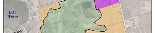
14 Map 1.2: Future Surrounding Land Use, Oak Ridges Corridor Park East 9
15 2 Vision and Values It is important that the vision and values for the ORCPE lands be integrated with those of the TRCA, the Humber River and Rouge River watersheds, and the management plan for the adjacent Oak Ridges Corridor Park. The visions, goals and objectives of all these plans were reviewed and incorporated as part of the process for developing the ORCPE management plan. 2.1 Towards a Living City Region Toronto and Region Conservation (TRCA) is committed to community partnerships with all sectors of society to encourage environmental stewardship and to build on innovative thinking about environmental health, social responsibility and sustainable economies. TRCA s vision of a Living City Region has four objectives: Healthy Rivers and Shorelines To restore the integrity and health of the region s rivers and waters from the headwaters in the Oak Ridges Moraine, throughout each of the nine watersheds in TRCA s jurisdiction, to the Toronto waterfront on Lake Ontario. Regional Biodiversity To protect and restore a regional system of natural areas that provide habitat for plant and animal species, improve air quality and provide opportunities for the enjoyment of nature. Sustainable Communities To facilitate broad community understanding, dialogue and action toward integrated approaches to sustainable living and city building that improves the quality of life for residents, businesses and nature. Business Excellence To produce continuous improvement in the development and delivery of all programs through creative partnerships, diverse funding sources and careful auditing of outcomes and effectiveness. Three key TRCA Living City strategies that have been integrated into this Management Plan to ensure a consistent watershed management approach include: Terrestrial Natural Heritage System Strategy Humber River Watershed Plan: Pathways to a Healthy Humber Rouge River Watershed Plan: Towards a Healthy and Sustainable Future TRCA s Terrestrial Natural Heritage System Strategy The Terrestrial Natural Heritage System Strategy (TNHSS) provides extensive data, scientific models, mapping and guidance for TRCA staff, TRCA s partner municipalities and community groups for achieving natural heritage protection objectives. The need for a TNHSS originated from observations by TRCA and others that showed an alarming reduction in vegetation communities and species populations, and their distribution within TRCA s area of jurisdiction. This change was occurring simultaneously with urban expansion despite best efforts at protection. The reduction in forests, wetlands, meadows and their species was also accompanied by an increase in flooding and erosion, and in conflicting recreational uses in protected areas. Changes in land use were being approved site by site without understanding how, cumulatively, they were impacting the region s natural system and environmental health. TRCA has redefined its approach towards biodiversity conservation to better reflect the role of ecosystems in the landscape. One important premise is that the distribution and 10
16 quantity of natural cover and species is intricately linked to water, air quality and climate regulation, quality of life, and sustainability for citizens of our Living City region. Conservation efforts should, therefore, not focus solely on the conventional protection of rare species or special natural areas. The TNHSS guides the natural heritage approach used in the development of this management plan. The approach considers the site within the context of the region and regional pressures. It provides clear and detailed direction for gathering and analyzing information about natural habitats, vegetation communities and species. This approach evaluates a site s contribution to the landscape at three levels: The entire TRCA jurisdiction Defined areas of planning units such as the watershed and subwatershed Municipal areas A key component of the terrestrial natural heritage approach is the scoring and ranking of vegetation communities and fauna species. The ranking information is used to determine if there are any species or vegetation communities of concern on the site. A second key component of the approach is the terrestrial natural heritage indicators and measures that are used to establish quantitative targets for the terrestrial ecosystem. The indicators are: Quantity of natural cover Distribution Matrix influence Patch size and shape Landscape connectivity Biodiversity The terrestrial natural heritage information that was gathered was analyzed and used to determine the appropriate management zones and trail alignments. The scoring and ranking of vegetation communities and fauna species reflects their primary resistance to urbanization and human encroachment. Species are ranked based on local distribution or local (L) ranks. These L ranks are in some ways analogous to the provincial (S) and global (G) rank that are assigned to vegetation communities, flora and fauna. The TRCA ranks range from L1 to L5. Generally, L1 to L3 species or vegetation communities are of regional conservation concern (i.e. within TRCA jurisdiction) and their locations have been protected through the plan. A complete copy of the biological inventory report for ORCPE, including listing of species and vegetation communities, can be found in the Oak Ridges Corridor Park East Management Plan Background Report (TRCA, 2010) The Target Terrestrial Natural Heritage System The goal of the target terrestrial natural heritage system is to protect and restore a system that is robust enough to sustain the existing distribution and populations of regional species of conservation concern. The target system quality still ranges from very poor to excellent but is improved overall, from being dominated by fair patches in the existing system to good patches in the target system. This results from improving individual patch size, shape, and, to some degree, matrix, throughout the system. The distribution of natural cover in the target system is still very much skewed to the north, generally within the Greenbelt area, largely because of the limited ability to increase natural cover in existing urban areas. 11
17 From a quantity perspective, the target system covers approximately 74,000 hectares, or approximately 30% of the total land surface area of the TRCA jurisdiction. This is the quantity necessary to achieve a target system that is dominated by good quality patches and to achieve the best distribution possible given existing constraints. The existing 25% of natural cover in the jurisdiction is made up of 16.5% forest and wetland and 8% meadow. With the quantity target increase to 30%, the intent is for the natural system to be 80% treed habitat (60% upland and 20% swamp), 10% meadow and 10% open wetland. In summary, the target system will see an increase regionally in terrestrial natural cover quality, from fair to good, and in quantity, from 25 to 30%, and will include a shift in the habitat type distribution. Additionally, the Greenbelt area (which includes ORCPE) will see increases in quantity and quality of terrestrial natural cover from 44% to 63% Humber River Watershed Plan: Pathways to a Healthy Humber (2008) Since the publication of the first Humber Watershed Plan (Legacy: A Strategy for a Healthy Humber) in 1997, much has been learned about the Humber watershed from monitoring, research and the experiences of watershed partners. The updated watershed plan revises the watershed management strategies in Legacy in light of new information, a stronger scientific foundation, and better understanding of the effects of human actions on the ecosystem. The guiding framework for the watershed plan is a set of principles and 30 objectives with specific targets for watershed conditions. They address: Environment: stream form, groundwater, surface water, air, aquatic system, terrestrial system Society: cultural heritage, nature-based recreation Economy: land use, resource use The plan includes a series of objectives and targets for improving the Humber River Watershed. Those that are relevant to the management of the ORCPE lands are outlined in appendix D, table D.1. Also in this table are the quantitative and qualitative contributions that the ORCPE lands can make towards accomplishing those targets. Relevant targets are discussed under the categories of: aquatic system; terrestrial system; cultural heritage; and nature-based recreation. An assessment of the health of the Humber River Watershed can be found in the Humber River Watershed Report Card (2007), which reports on the indicators in the 1997 watershed plan. The three main categories of indicators in the report cards are: Environment; Society and Economy; and Getting it Done. As with the watershed plan, the protection and stewardship of the ORCPE lands will contribute to many of the indicators and objectives, in ways similar to what is outlined in appendix D, table D Rouge River Watershed Plan: Towards a Healthy and Sustainable Future (2007) 12
18 The watershed plan was prepared by a multi-stakeholder task force that included representatives from all levels of government agencies, private businesses, not-for-profit organizations and the public and was coordinated by TRCA and Rouge Park. The plan has a strong technical foundation, based on decades of monitoring of environmental conditions combined with a leading edge approach to modeling of potential future conditions. A series of management summits was held to convene experts who could help identify best practices and recommendations to achieve the objectives of the Rouge Watershed Task Force. The guiding framework for this watershed plan comprises an overall goal, a set of principles, nine goals and 22 objectives with specific targets. The overall goal is: To work towards a healthy and sustainable Rouge watershed by protecting, restoring and enhancing its ecological and cultural integrity within the context of a regional natural heritage system. The goals, objectives, and targets address: Groundwater Surface water Stream form Aquatic system Terrestrial system Air quality and climate change Cultural heritage Nature-based recreation Sustainable land and resource use The pathway to a healthy watershed is based on a comprehensive and inter-dependent set of strategies that will protect and enhance valued resources, regenerate damaged systems, and build more sustainable communities. The plan includes a series of objectives and targets for improving the Rouge River Watershed. Those that are relevant to the management of the ORCPE lands are outlined in appendix D, table D.2. Also in this table are the quantitative and qualitative contributions that the ORCPE lands make towards accomplishing those targets. Relevant targets are discussed under the categories of: aquatic system; terrestrial system; cultural heritage; and nature-based recreation. 2.2 Oak Ridges Corridor Park Management Plan (2006) The Management Plan for the Oak Ridges Corridor Park was developed after considerable discussion with representatives from government, non-government organizations (NGO s) and private citizens. A vision for the park was determined as follows: The Oak Ridges Corridor Park will be a sanctuary for nature and an essential ecological linkage on the Oak Ridges Moraine where visitors can learn about ecosystem features and functions, wildlife and human influences, and enjoy activities that are compatible with the natural and cultural values of the park. Input was sought to identify goals and objectives for the park, and information from earlier studies was used to identify an east-west trail alignment and to develop a habitat restoration plan. A key recommendation within the management plan was the 13
19 development of a 5km long spine trail extending from the Bathurst Glen Golf Course across Yonge Street to a trailhead on Old Colony Road, and eventually to the proposed Oak Ridges Community Centre. All the existing natural forests, lakes and wetland habitats will be fully protected. A restoration plan for the majority of the lands that were in agricultural use prior to the land acquisition was developed. The major focus is on reforestation and developing a treed canopy as quickly as possible that will serve to buffer and expand the natural forests. Other restoration initiatives will include establishing grasslands where possible on the drier upland sites and creating additional small wetlands in lowland areas to enhance biodiversity and assist in amphibian dispersal and breeding. The management plan includes a recommendation for the formation of a Park Management Committee that would include representatives from provincial, regional and local government, as well as non-government organizations. It also suggests the creation of a Friends of the Park stewardship group that would liaise with TRCA. To ensure that the Corridor Park achieves its objectives, the management plan recommends that its relationship with surrounding lands and opportunities for expansion both to the east and west be considered. There should be integration of the park with other natural areas on the Oak Ridges Moraine to ensure that a truly sustainable ecosystem is preserved and the unique features of the area are protected for future generations. 2.3 Vision and Values During the management planning process for the Oak Ridges Corridor Park, a vision, goals and objectives were developed through an extensive consultation process. Given the intent to integrate the management of the two properties, it is logical that the management planning framework for the two documents be closely aligned. However, it is also essential to note that the ORCPE lands contain important natural heritage features that are unique to those lands. Additionally, the management plan framework should recognize that the ORCPE lands are currently surrounded by a predominantly agricultural matrix that is slated to be developed to medium density residential communities that will include approximately 2,020 residential units. Through consultation with the various committees, it was determined that the ORCPE Management Plan would follow the vision laid out in the Oak Ridges Corridor Park Management Plan, and reads as follows: The Oak Ridges Corridor Park East will be a sanctuary for nature and an essential ecological linkage on the Oak Ridges Moraine where visitors can learn about ecosystem features and functions, wildlife and human influences, and enjoy activities that are compatible with the natural and cultural values of the park. Given the importance of recognizing the unique features of the ORCPE lands, the committees felt it was worthwhile to develop a series of value statements for the ORCPE Management Plan. These are titled the Values for Sustainability, and are as follows: ECOLOGICAL 14
20 Recognize that protected natural heritage is essential to the health and future of the watershed and must be protected and enhanced so it can be used and enjoyed by future generations. CULTURAL Value and protect linkages to the history and past uses of an area and use their lessons to help guide present and future actions. SOCIAL Foster development and engagement of community members as a key to building a stewardship ethic. Recognize and value people s connections to land and provide recreation and experiential learning that is compatible with the natural and cultural values of the land. ECONOMIC Encourage long-term economic vitality through strategic planning and partnership development. In addition, the following goals exist for the management and use of all Conservation Authority and partner-owned lands, and will guide the management planning process for the ORCPE lands: To conserve, protect and manage Authority lands in consultation with the public in a manner that values, respects and enhances the natural, cultural and heritage resources; and, To encourage uses that are compatible with healthy watersheds, respectful of the unique character of the lands and sustainable in environmental, physical and economic terms. 15
21 3 Existing Environment 3.1 Terrestrial Natural Heritage Natural heritage includes the physical, chemical and biological elements of the natural environment what is often termed nature or the environment. A natural heritage system refers to the interactions and dependencies between and among the physical, chemical and biological elements of natural heritage. It is these interactions that control the hydrologic cycle and the quality of habitat for plants, animals, birds and fish. This section highlights the terrestrial natural heritage system at ORCPE. However, ORCPE s natural heritage should not be considered in isolation. It is connected to the lands beyond its boundaries, as well as to the greater Humber River and Rouge River watersheds. The following information is based on field work conducted by TRCA staff as well as field inventories and records from the Ontario Ministry of Natural Resources (OMNR, 2000a, OMNR 2000b). The purpose of TRCA s field work at this site was to provide a comprehensive inventory of terrestrial natural heritage features in order to provide a background technical report to be used in the development of the management plan. The full text of the biological inventory can be found in the Oak Ridges Corridor Park East Management Plan Background Report (TRCA, 2010). Through this inventory, the site features can then be understood in the larger regional context of the Terrestrial Natural Heritage System of the TRCA (see section 2.1.1). It is key that the health of the natural system, measured at both the regional scale and site specific scale, be considered together to achieve benefits at all scales. Highlights 80 vegetation communities, including 27 of regional concern: wetlands very wellrepresented, but also forest and sand barren Total of 471 vascular plant species observed flora species of concern, including 3 provincially-rare species and 14 provinciallyuncommon species Quality of site is at risk; 10 flora species not seen in recent decades; loss of 5 significant fauna species over the past decade Total of 81 vertebrate fauna species observed with 28 of these being of regional concern Total of 59 breeding bird species observed The site holds at least 11 reptile and amphibian species of regional concern 121 hectares of forest, much of it high-quality 13 hectares of wetland and aquatic communities, mostly associated with kettles (TRCA, 2010) The ORCPE lands are located in the headwater areas of the Humber River and Rouge River watersheds. The site is noteworthy for the large forest complex it contributes to, which includes the Jefferson Forest Area of Natural and Scientific Interest (ANSI) to the south of the property, and for contributing a diversity of high quality habitats to the 16
22 ecosystem functions of the headwater region. The site also provides important habitat in the middle of the Oak Ridges Moraine where forest cover is lacking. The site lies within the southern portion of the Great Lakes St. Lawrence floristic region. Mixed coniferous deciduous forest was the dominant pre-settlement condition, interspersed by wetlands. It is located on the Oak Ridges Moraine, featuring very distinct kame-and-kettle topography and much variation in soil type. The northern half of the property has fine sands and silts with numerous depressions or isolated kettles (OMNR 2000b). Slopes are often steep. Organic matter has accumulated in most of the scattered wetland kettles. One kettle in the northeast part of the site contains Swan Lake, a small kidney shaped kettle lake approximately 3,000 square-metres in size. The central portion of ORCPE is flatter and covered in glacial Halton till deposits of calcareous silts, with loamy soils, underlain by thick sand deposits. The southern half is vigorously rolling morainal deposits of find sands and some gravels (OMNR 2000b) Natural Heritage System The following description of the property uses the two landscape-level natural system indicators, used in designing the Terrestrial Natural Heritage Target System (see section 2.1.1): the quality distribution and quantity of natural cover. The results for quality distribution are further broken down into habitat patch size and shape, matrix influence and total score. The maps supporting this data are found in appendix A. In the ORCPE lands, the majority of the habitat patches receive a good score for patch size, meaning that they score four out of a possible five points (i.e. at least 50 hectares in size for forests and 10 hectares for wetlands). A few receive only one or two points, but these smaller patches are generally embedded in the larger good patches and thus are probably still functioning effectively. Map A.1 (appendix A) illustrates habitat patch size scores. Figure 3.1: Habitat Patch Size Scores, Oak Ridges Corridor Park East Forest interior provides shaded, moist, cool conditions, and some refuge from external impact; the conditions needed for numerous native plants and animals. The largest area 17
23 of forest interior at ORCPE occurs in the southwest forest block where a fairly large area of forest is more than 200m from the forest edge (see map A.2, appendix A). The habitat patches in the ORCPE lands receives a good matrix influence score (see maps A.3 and A.4, appendix A). This can be attributed to the proximity of large areas of natural cover to the north (Lake St George Conservation Area and Field Centre) and south (Jefferson Forest Area of Natural and Scientific Interest) of the site, the proximity of Lake Wilcox, and the fact that much of the surrounding land is still agricultural. As the surrounding agricultural land is converted to an urban land use, restoration efforts on site to increase the amount of existing habitat will become even more important. Habitat patch size and shape within the site will need to improve considerably to offset the negative influences that are commonly associated with urban land uses (e.g. changes in hydrology, compaction of soils, invasive non-native species, increased recreational pressures, etc.). The map showing habitat patch total scores (map A.5, appendix A) shows that almost the entire ORCPE lands are represented by the L3 or fair patch quality (receiving a score of 9-10 points). The habitat quality at the site is thus roughly equivalent to the average condition in the TRCA jurisdiction. However, ORCPE supports an impressive number of Regional Species of Concern, more in keeping with a higher ranking total patch score. This discrepancy is due to the fact that the total patch score is lowered by a very poor score associated with habitat patch shape as a patch becomes larger, patch shape becomes less determinative of what that habitat patch can support. In other words, as restoration work on the site increases the amount of natural cover and therefore the size of habitat patches, total habitat patch score has the potential to increase. In terms of natural cover, 86% of the ORCPE lands are currently classified as natural cover. This includes hectares of forest, 40.1 hectares succession, 10.5 hectares of wetland, 2.2 hectares aquatic, and 21.6 hectares of meadow. These areas are further described in the following section Vegetation Community The ORCPE lands were inventoried using the Ecological Land Classification (ELC) system, which defines ecological units on the basis of bedrock, climate, physiography and corresponding vegetation (OMNR, 2007). A total of 80 different ELC vegetation community types were described for the site (TRCA, 2010). This extremely diverse assemblage of communities derives from the wide range of topographic features (kame and kettle), soils (silt loam to the north, sand to the south, and organic deposits in many of the wetlands), and land use history of the site. The ORCPE lands contain excellent examples of some of the unique features found on the Oak Ridges Moraine. Relatively large tracts of mature upland forest and scattered kettle wetlands are surrounded by a mostly agricultural and natural matrix causing only mild anthropogenic impacts. The natural habitat within the block makes up the majority of the provincially significant Lake Wilcox Kettle Wetlands and Uplands Area of Natural and Scientific Interest (ANSI), which is also identified as an Environmentally Significant Area (ESA) by TRCA. 18
24 Forest covers hectares of the property, with 37 different forest community vegetation types identified. The range includes: coniferous, mixed, and mostly mature deciduous forest in addition to some younger poplar and birch forests. The largest share is occupied by sugar maple forest and white pine hardwood mixed forest. Important constituent species of the mixed forest include large-toothed aspen (Populus grandidenta), red maple (Acer rubrum), and red oak (Quercus rubra). Conifer plantations of various types cover six hectares. The successional communities (40.1 hectares) include disturbed areas dominated by European buckthorn (Rhamnus cathartica) (14.7 hectares). European buckthorn has encircled much of the western kettle wetlands, creating dense exotic thickets and forming the understorey in some of the forested sections. The long-term viability of native forests surrounding the kettle wetlands and in other lowland areas is being severely compromised by the buckthorn invasion. Buckthorn has also been spreading across the northern meadows, forming thickets. Regenerating habitats that include staghorn sumac (Rhus typhina), hawthorn species (Crataegus spp.), and groves of trembling aspen (Populus tremuloides) form an essential link between the kettle wetlands and upland forests in the north and south. Without the current disturbance of off-road vehicles in the successional areas these communities would eventually covert back to full canopy cover. These areas comprise 20.5% of the site s natural cover. Wetlands cover only 2% of the Oak Ridges Moraine, with most consisting of small isolated kettle wetlands or small headwater wetlands (OMNR 2000a). This is one of the reasons the ORCPE lands are so unique. They contain many kettle wetlands within the provincially significant Wilcox-Lake St George Wetland Complex, a large and diverse community of wetlands noteworthy for its four lakes and four kettle peatlands, two of which are found within the property (OMNR, 2000a). These kettles are dotted across the northern half of the properties. There are 10.5 hectares of wetland and 2.2 hectares of aquatic habitat, making up 6.5% of the site s natural cover. The largest wetland patch surrounds Swan Lake. Two of the largest kettle peatlands of the wetland complex are within the ORCPE lands. The first is surrounded by native forest and almost completely isolated from disturbance. To the northeast is the second peatland, which fills the southern extension of the Swan Lake kettle. The site also contains a variety of swamp communities, including treed swamps, organic shrub swamps, and shallow marshes. Abandoned agricultural fields have been replaced by meadows, as recently as in the last three years. A total of 21.6 hectares of meadow were surveyed (11% of the site s natural cover). Disturbance from motorized vehicles has likely prevented some meadow communities from carrying out successional processes and also impeded their ability to sustain native species. On the sandier soils to the south, disturbance and drought have resulted in a sand barren community, which occurs as part of a hilly meadow area. In this case, the motorized vehicles may have helped to maintain the open character of the community, although there would be less damaging ways of doing so, such as soil scarification or prescribed fire. 19
25 Vegetation Communities of Concern Twenty-seven of the 80 vegetation communities found at ORCPE are considered to be of regional concern, as illustrated in map A.6 (appendix A). Ranks are based on two criteria local distribution and geophysical requirements. For forest communities, the age of the community, as well as the diversity and quality of the understorey and ground layers are also considered. Wetlands comprise 18 of the vegetation communities of concern, including kettle bogs, marshes. Several forest types are ranked of concern, including white pine oak mixed forest, poplar mixed forest, and hickory deciduous forest. Looking at the criteria of local distribution, five communities at ORCPE are considered regionally rare in the TRCA jurisdiction, including four kettle wetland communities and a hickory deciduous forest community. The variation in topography and soil type at ORCPE supports the wide range of vegetation communities. The hydrology is crucial for many of the wetland and forest communities present at the site, and represents a considerable point of vulnerability for the many species who make their homes in the kettle communities or in cool, moist habitats. Any change in the site s hydrological conditions would likely pose serious implications to the present biodiversity found on the site, and would threaten several species or entire vegetation communities Flora The diverse habitats of ORCPE are home to a plethora of plants that require either high quality wetland or forest, the ecotone between forest and wetland, or in some cases open places such as sand barrens. A total of 471 naturally occurring flora species have been found in the ORCPE lands. Of these, 113 are exotic species, which make up only 24% of the total; however a few are serious invasives, notably European buckthorn. Flora Species of Concern A total of 148 of the 471 vascular plant species identified at ORCPE were found to be of regional concern, as shown in map A.7 (appendix A). Most of the flora species of concern are not rare plants by definition, since the ranking is based on sensitivity to development (e.g. hydrological change, trampling, and pollution) and restriction to certain habitats within the TRCA region as well as abundance considerations. However, the flora of ORCPE does include two provincially-rare species that were observed in the 1990 s: pasture thistle (Cirsium discolor) and sharp-leaved goldenrod (Solidago arguta var. arguta), which is considered provincially sensitive. Butternut (Juglans cinerea,), which was found in three locations, is also listed as endangered under the Federal Species at Risk Act, and is declining due to butternut canker. Fourteen species at ORCPE can be considered provincially uncommon and 51 species are rare in the TRCA jurisdiction. Population declines are likely affecting many of the more sensitive flora at ORCPE. Three historic species of the peatlands have not been found in recent decades. One species is believed to be extirpated, and several others have not been seen since the 1980 s or very early 1990 s. Declines in native flora diversity in settled or partiallydeveloped landscapes are often slower than with fauna, occurring over a scale of several decades. There has been much urbanization of the matrix in the vicinity of 20
26 ORCPE and surrounding area, with increasing recreational impacts, and a lot of this has occurred since the year Habitat specialist plants and those sensitive to various anthropogenic impacts are most affected, and will likely continue to be impacted as further urbanization surrounds ORCPE. More detail on these impacts, and their documentation where possible, is described in the Oak Ridges Corridor Park East Management Plan Background Report (TRCA, 2010) Fauna A total of 59 breeding bird species, 10 mammals, and 12 herpetofauna species have been observed at ORCPE, for a total of 81 species (TRCA, 2010). This total is comparable to other high quality sites in the northern reaches of the TRCA jurisdiction, such as Glen Major and Palgrave properties. Fauna Species of Concern Of the 81 species recorded for ORCPE, the following are considered of regional concern in the TRCA jurisdiction: 17 bird species, 11 herpetofauna, and one mammal (map A.8, appendix A). Ranks for fauna species are obtained through a set of five scoring criteria; including local occurrence, sensitivity to developments, area sensitivity, patch isolation sensitivity, habitat dependence, local population trends and continent-wide population trend. Eight species within ORCPE are considered regionally rare (local occurrence), including Jefferson salamander (Ambystoma jeffersonium), red-spotted newt (Notophthalmus viridescens), spotted salamander (Ambystoma maculatum) and broad-winged hawk (Buteo platypterus). As is the case with flora, most regionally rare fauna species have other associated factors that explain their vulnerability and need to be taken into account in conservation strategies. Many of the fauna species at ORCPE are dependent on forest conditions that are unlikely to persist if urban matrix influences are allowed to encroach. Representation is essentially the presence or absence of a species at a site. However, beyond mere representation of single species is the idea that a natural system can be considered as a healthy functioning system if there is an association of several species thriving within that system. Each habitat type supports particular species associations. As the quality of the habitat patch improves, so will the representation of the flora and fauna species within that habitat. In this way, representation is an excellent measure of the health of a natural system. The presence of so many habitat dependent species in particular, species that are dependent on forest, indicates that the forest habitat at the ORCPE lands is functioning at a relatively high level. However, the loss of certain highly sensitive species over the past decade gives cause for concern. Similarly, the planned urbanization of the surrounding landscape will require increased efforts to protect habitat quality and underscores the importance of careful monitoring. 3.2 Aquatic Resources While there are no watercourses identified on the properties, given their proximity to the headwaters of both the Rouge and Humber River watersheds, management of the lands can still influence stream integrity. Upwards of 90% of a river system s total flow may be derived from headwater catchments (TRCA, 2007). From this, headwater streams are considered to be important sources of water, sediment, nutrients and organic matter to 21
27 downstream reaches. They can also be direct seasonal habitat to a variety of fish and benthic invertebrate species. Forest cover allows for increased infiltration and retention of water that in turn helps to maintain and restore flow balance and groundwater discharge to streams. Similarly, wetlands play a key role in maintaining water balance. The wetlands of the Upper East Humber subwatershed, in which the ORCPE properties are located, have been identified within TRCA s Terrestrial Natural Heritage System and are referenced in the Humber Fisheries Management Plan (2008) as being priorities for protection. The properties are located within Fisheries Management Zone 1 under the Rouge Fisheries Management Plan (in progress), which have target species of redside dace, brook trout, American brook lamprey, mottled sculpin, and rainbow darter. Redside dace is listed as provincially endangered under the Ontario Species at Risk Act (2007) and nationally a species of concern, currently under review for uplisting to status of endangered under the Species at Risk Act (2002). The largest aquatic resource within ORCPE is represented by Swan Lake. Swan Lake is located approximately one kilometer east of Lake Wilcox in Richmond Hill and is a relatively small, kidney-shaped kettle lake, with a surface area of approximately 3000 square metres and a depth of 8 meters at its deepest point. Fisheries monitoring of Swan Lake carried out in summer 2009 revealed Brown bullhead catfish (Ameiurus nebulosus) as the only fish species found during the surveys. To gain a more comprehensive understanding of the lake s fishery, future efforts should include multiple sampling sets during spring, summer and fall. Swan Lake also provides habitat for a variety of common amphibians and bird species. 3.3 Human Heritage The area surrounding the ORCPE has been inhabited for thousands of years, first by Aboriginal peoples and later by European settlers who took advantage of the abundance of available natural resources. It contains archaeological resources that have been identified, and holds high potential to encounter more archaeological sites, both of EuroCanadian and Aboriginal nature. Future studies should be initiated to identify these unidentified cultural resources. The following sections provide a brief overview of the cultural heritage elements that contribute to the diversity and rich history of this area Archaeology Though archaeological sites are most commonly described as locations where artifacts (i.e. Aboriginal stone tools) or features are encountered, a broader, more inclusive context, cultural heritage landscapes, has been used to evaluate the archaeological potential of the ORCPE. The history of the property was studied within this context in order to identify and promote the potential cultural heritage features that may be encountered as the management plan process unfolds. Evidence of occupation within the vicinity of the ORCPE spans 12,000 years. More detail of the aboriginal history of southern Ontario can be found in the Oak Ridges 22
28 Corridor Park East Management Plan Background Report (TRCA, 2010). Specifically, 33 archeological sites were identified as of 2009 within the 1,000 square acres that include Lots 1 through 5 in Concession 2, Whitchurch Township. The majority of the sites are located near Swan Lake, with the remainder scattered throughout the area and not necessarily within the ORCPE property. There are 32 registered Aboriginal sites and one registered EuroCanadian site. More detail on these artifacts can be found in the background report document mentioned above Settlement Map 3.1 provides historical context for the ORCPE lands, and includes Lots 1 through 5 Concession 2. It depicts geographical features such as lakes and rivers, names of the landowners, as well as structures such as homesteads, barns, mills, and orchards. A detailed accounting of the history of each lot can be found in the background report. Of interest is the high potential for both Aboriginal and EuroCanadian sites in the area surrounding Swan Lake, as it would have provided important natural resources to those people Recent History More recent history at ORCPE has seen a cottage community, a golf course, farms and orchards. Details regarding this history, including an accurate timeline, are difficult to come by, however a short summary has been assembled from speaking to area residents. A cottage community existed in the area southeast of Bayview Avenue and Bethesda Sideroad. It would have been established in the early 20 th century, when the rail line ran through the community, then expanded in the 1920 s with the introduction of the automobile. The area was also home to a golf course, located east of the cottage community. Local knowledge confirms that it, and the cottage community, existed until the 1980 s. Both were likely sold in the mid 1980 s during the housing collapse, and the cottages were later bulldozed Existing Use Uses Made up of forest, wetlands and meadows, the predominant land use at ORCPE is natural cover. Within those natural areas however, there are extensive damaged areas. The most noticeable is in the northern half of the property, where a large network of trails and runs has been created by motorized vehicles. The damage is so extensive that it can easily be seen on aerial photography. Restoration efforts are already underway to repair this damage, and will be on-going into the future. A similarly damaged area exists on one of the parcels owned by the Province of Ontario, immediately east of Bayview Avenue adjacent to the road bridge. In addition to these highly impacted areas, the wooded areas are bisected by a network of informal trails. An assessment of these informal trails was carried out as part of the management planning process, and is further discussed in chapter six. ORCPE encompasses a number of fields that are in active agriculture use, with crops rotated annually. Many of these fields may represent an excellent opportunity for restoration, particularly those that will be landlocked once future development is constructed. The large fields immediately adjacent to Bayview Avenue have already been targeted for reforestation, as was outlined in the management plan for the Oak 23
29 Ridges Corridor Park. A number of the fields surrounding Swan Lake have also been targeted for restoration, in an effort to protect and enhance the health of the lake ecosystem and surrounding wetlands. The remaining fields were surveyed and assessed for their restoration potential as part of the management planning process, and recommendations are discussed in chapter five. There is an active audience of users of the property. Some are clearly engaging in unauthorized uses, such as the riding of motorized vehicles including ATV s, dirt bikes, and 4-wheel drive vehicles. The Oak Ridges Corridor Park East Site Securement and Protection Plan was created in 2007 and can be found in appendix F. This report outlined major recommendations for ending unauthorized use, many of which have been implemented since the completion of the report. Of the 21 potential and existing access points that were listed in the report, eight sites have been blocked through the installation of fencing or barriers, and two are no longer an issue as the adjacent property has been acquired by TRCA. Six sites are no longer a concern, either because the access has been deemed legitimate (e.g. used for agricultural lease), or the access has ceased to be used. Five sites still have the potential to allow unauthorized access, though currently they are not used heavily. Other uses are more passive such as hiking, cross-country skiing and snowshoeing. The property is used by mountain bikers, some of whom appear to create and ride jumps and stunts at various points throughout the property. The property is regularly surveyed for jumps and stunts, which are promptly removed due to safety concerns, as well as impact to the environment. There may also be some cross-country mountain bike riders who use the extensive informal trail system. Access The primary access points for ORCPE that are currently in use are on Bethesda Sideroad and Stouffville Sideroad. The two maintenance entrances on north side of Stouffville Road are used as access points, as is the entrance on the south side of Bethesda Sideroad, located just east of the edge of the TRCA property boundary. Many unauthorized users access the property from various points along Bethesda Sideroad, including by passing through the privately owned property located southeast of Bayview Avenue and Bethesda Sideroad. Extensive efforts in recent years have served to block many of these informal entrance points, though continued efforts are required to replace barriers that are removed by users with trucks or other motorized vehicles. Unauthorized motorized vehicles did historically access the property via the old Bayview Avenue road allowance, although that has recently been fenced and gated to prohibit access. In the past, users did access the property from Bayview Avenue, particularly in the area of the Bayview Avenue bridge, south of Old Colony Road. However, the fencing that has since been installed along the road edges has minimized this access. Further investigation will be required to determine whether access is still an issue from the housing developments west of the bridge. Parking There is currently no authorized parking for ORCPE. Visitors do park vehicles in the maintenance entrances on the north side of the Stouffville Sideroad, as well as on the residential roads on the south side of Stouffville Road. Parking will be addressed as part of this management plan, and is further discussed in chapter six. 24
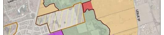
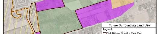
30 Surrounding Land Use ORCPE is close in proximity to the northern boundary of the Municipality of Richmond Hill; therefore, much of the land surrounding the property is currently agricultural or low and medium-density residential housing. To the north, it is bordered by agricultural lands and TRCA s Lake St. George Field Center. To the south, ORCPE is bordered by low-density housing, a large woodlot, and Summit Golf & Country Club. To the east, the property is bordered by agricultural lands and some low-density residential. To the west of Bayview Avenue lies the main Oak Ridges Corridor Park, which is surrounded by medium-density residential development. There is also a small subdivision of mediumdensity homes immediately east of Bayview Avenue, adjacent to the parcel owned by the Province of Ontario. Map 1.2. (Chapter one) shows the future land use for ORCPE. Much of the land surrounding ORCPE is slated for development. To the northwest, approximately 16 hectares will be developed into a medium-density residential community and a municipal park. To the east, approximately 90 hectares will be developed into a residential community, including schools and parks. There are a number of parcels that will remain under private ownership, located to the northeast and southeast of ORCPE. 25

31 Map 3.1: York County, Whitchurch Township 26
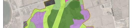
32 4 Management Zones Management zones are developed as part of the management planning process to guide how the property is managed where ecological features must be protected, where public use and trails will be permitted, or where restoration efforts will be focused. The zones are distinguished by their different levels of ecological protection, management needs and acceptable levels of public use. 4.1 Determining the Management Zones The management zones used in this management plan are based on those outlined in the Ontario Provincial Parks Planning and Management Policies (MNR, 1992). However, the recommended conservation land management zoning categories and policies have been modified to more closely address the requirements of ORCPE and TRCA. Extensive natural and cultural heritage information was compiled for the Oak Ridges Corridor Park East Management Plan Background Report (TRCA, 2010) that was developed as part of phase one of the management planning process. This information is summarized in chapter three and forms the basis for determining the management zones. The key information that was analyzed and ranked for the management zones included: Interior habitat Vegetation communities Species of concern Environmentally Significant Areas (ESA s) Areas of Natural and Scientific Interest (ANSI s) Classified and unclassified wetlands Existing infrastructure and public use areas (e.g. trails) In addition to review of the background report information, a landscape level scenario analysis was conducted. The maps illustrating this scenario analysis can be found in appendix B. The analysis is done at the watershed level, and looks at the impacts of a variety of factors on the habitat patch quality (ranked L1 excellent through L5 very poor ). For the scenario analysis, three scenarios were run. The first looked solely at existing conditions and ranks most of the property as L2 or good, with some areas ranking as L3 or fair (map B.1). The next scenario estimates the impact of a full build out as planned under the municipal official plans, assuming that all areas targeted for development are developed (map B.2). In this scenario, the habitat ranking across the property falls to a level of L3 or fair, with some patches as low as L4 or poor. The last scenario shows the same build out conditions, but with all potential restoration areas restored to natural cover (map B.3). In this scenario the majority of the property is once again ranked as L2 or good, with only a few small patches remaining as L3 or fair. This scenario analysis is particularly relevant for the ORCPE given that much of the land around it is slated for development in the near future. The projected impact of that development on the habitat quality of ORCPE underscores the importance of not only protecting the existing features, but of increasing the extent of natural cover through restoration. 27
33 The scenario analysis is a helpful tool in projecting the landscape level impact of future developments. Because it is limited in its ability to reflect site level impacts, an additional mapping exercise was conducted to further examine the potential impacts associated with the planned development around ORCPE. This analysis looked at the highest impact zones at ORCPE, based on the location of the proposed developments, the anticipated user traffic flows (e.g. hikers, dogwalkers, cyclists) from those communities, and the sensitivity of the various natural features throughout the property. Areas where highly sensitive or important natural features were located close to proposed residential areas or anticipated traffic flows were anticipated to have the highest potential impact, and are shown in red on map B.4, in appendix B. Natural areas that are in proximity to the development or traffic flows but are of lower quality, or those of high quality but at a distance from the aforementioned disturbances, received a lower potential impact score and are shown in yellow. Green areas are anticipated to receive the lowest impact, and represent those that are of lower quality and are located at a distance from both development and traffic flow. This process serves to highlight areas that are in particular need of protection, as well to suggest where restoration could serve to mitigate the potential impacts of development. 4.2 Defining and Mapping the Management Zones Both the landscape level scenario analysis and the site level impact analysis are reflected in the management zones, and also inform the management recommendations in chapter five and the trail plan recommendations in chapter six. The management zones used at ORCPE are as follows: nature reserve, natural environment, primary restoration, secondary restoration, and public use. Definitions for these zones are found in table 4.1. A listing of the types of resources uses, and levels of use that are permitted in these zones, are listed in table 4.2. Permitted uses for the trail system are discussed in more detail in chapter six. The management zones for ORCPE are represented in two maps. The first, map 4.1, represents the current management zones. These are intended to guide management of the property for the next five to ten years. The second map, map 4.2, shows future management zones, and is intended to illustrate the vision or target for ORCPE. For example, the current management zone map shows areas that are targeted for active restoration, while the future management zone map will show that same area being managed as a nature reserve. When looking at the future management zone map, the majority of the property (72%) is designated as nature reserve. The rationale for this is based on the premise of protecting the sensitive natural features of the property, and of minimizing the area in which public use impacts will take place. Public use, in the form of trails, is only to be permitted in the natural environment zones. The natural environment zones are laid out in broad corridors, providing flexibility for trail alignment within those zones. While portions of these corridors may possess features making them appropriate for designation as nature reserve, the need to accommodate a connected trail system through these areas necessitated the need to zone these corridors as natural environment. Primary restoration zones are shown on the current management zone map (map 4.1). More detail on the plans for these restoration zones can be found in appendix C, 28
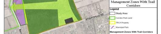
34 including the types of restoration project planned (e.g. wetland, riparian, meadow, forest). Figure 4.1: Percentage of Current Management Zone Designations, Oak Ridges Corridor Park East 2% 1% Agricultural 33% 31% Environmental Education and Research Natural Environment Nature Reserve 1% Public Use 32% Primary Restoration Figure 4.2: Percentage of Future Management Zone Designations, Oak Ridges Corridor Park East 1% 2% 1% Agricultural 24% Environmental Education and Research Natural Environment Nature Reserve 72% Public Use 29
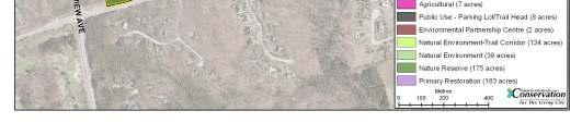
35 Table 4.1: Management Zone Definitions Management Zone Nature Reserve Natural Environment Primary Restoration Environmental Education and Research Agricultural Public Use Definition Areas which have significant or unique natural features, landforms, species or habitats that require careful management to ensure long-term protection. Large core habitat areas and corridors that are natural in character, but do not meet the criteria of the nature reserve zone. Priority lands within the property where ecological health and diversity should be enhanced through active environmental restoration. Lands designated for informal and formal education and research activities with an environmental focus, and accompanying infrastructure. Areas designated for active agricultural use or similar resource use. Areas which have existing or potential for recreational and educational uses, facilities or services. Table 4.2: Management Zone Resource Uses Permitted Intensity of Example Resource Uses Management Zone Uses Nature Reserve None to low intensity Research, monitoring, natural feature protection, habitat management. Natural Environment Low Intensity Local and inter-regional trail, nature viewing/interpretation, education, habitat management, research and monitoring Primary Restoration None to Low Intensity Local and inter-regional trail, nature viewing/interpretation, education, habitat management, research, monitoring, and natural feature protection. Environmental Education and Research Low to High Intensity Informal and formal education and research activities and infrastructure, local and interregional trail, nature viewing/interpretation, habitat management, monitoring, and natural feature protection. Agricultural Low to Moderate Intensity Crops, horticultural operations, and associated buildings. Public Use Low to High Intensity Parking lots, trailheads, and associated structures or facilities 30

36 Map 4.1: Current Management Zones, Oak Ridges Corridor Park East 31


37 Map 4.2: Future Management Zones, Oak Ridges Corridor Park East 32
38 5 Management Recommendations The management recommendations are intended to guide the actions of TRCA, its partners and stakeholders to ensure the ORCPE will remain a healthy and vital part of the Rouge River and Humber River watersheds. The recommendations have been separated into the following categories: ecological (encompassing natural heritage protection and restoration), cultural (encompassing protection and interpretation of cultural heritage resources), social (encompassing trails, site securement and stewardship) and economic (encompassing partnerships and implementation funding) While general recommendations for trails are outlined here, a detailed trail plan is contained in chapter six. Recommendations addressing the integrated operations and management of the ORCPE lands and the main Oak Ridges Corridor Park are dealt with in a separate section at the end of the chapter (see section 5.5). Each section has a number of general management recommendations, as well as specific management actions. The management actions are measurable, while the recommendations are broader statements. The management actions are summarized in a table in chapter seven, which also discusses budget, timelines and roles and responsibilities for implementation. The recommendations and actions are consistent with the watershed plans for the Rouge River and Humber River, and will contribute towards the targets laid out for each watershed. The general objectives of the watershed plan are discussed in each section below, and more detailed targets, including the contributions that ORCPE will make towards those targets, can be found in appendix D. The recommendations and actions in the following sections are based on the technical findings from the various background studies and inventories completed as part of the management plan process, and presented in the Oak Ridges Corridor Park East Management Plan Background Report (TRCA, 2010). 5.1 Ecological Natural Heritage Protection The recommendations in this section are intended to protect and maximize the contribution of the ORCPE lands to the wider natural system. Protection of the natural features at ORCPE is important for the health of the headwater system, for maintaining the connection to Jefferson Forest to the south and the natural cover to the north, and for its contribution to the east-west Oak Ridges Moraine corridor. The study area has an impressive diversity of habitat types that includes a high number of vegetation communities, flora, and fauna species that are of concern in the region, many of which are associated with the high-quality kettle wetlands and adjacent upland forests that occur at this site. 33
39 ORCPE is to be managed with an environment-first approach, meaning that natural heritage protection will be a key part of all management recommendations, such as location of restoration projects, design and construction of the trail system, and development of a stewardship program. The recommendations included in this section are specific to the protection, enhancement and monitoring of the natural heritage resources at ORCPE. In addition to the broad recommendations listed below, specific management actions are laid out according to category (e.g. hydrology, invasive species, and species of concern). The Humber River Watershed Plan and the Rouge River Watershed Plan have as one of their objectives: the protection, restoration and enhancement of natural cover to improve connectivity, quality, biodiversity and ecological function. They aim to minimize the negative influences from surrounding land uses on terrestrial system quality and function. A number of the following management recommendations and actions will support these objectives and the associated targets, including protection of existing sites, enhancement of natural cover through restoration (including forest, wetland, and meadow habitats), and mitigation of severely disturbed areas. A list of targets for the Humber River and Rouge River Watersheds, and detail on how the ORCPE lands will contribute to those targets, can be found appendix D, tables one and two. Some representative targets include: Increase natural cover to at least 30 per cent of total watershed area Increase wetland cover to 10 per cent of total watershed area Reduce baseline ratios of severely disturbed area to total evaluated areas Enhance and expand native habitat and species type representation in the terrestrial system Management Recommendations For both aquatic and terrestrial ecosystems, annual monitoring of the flora, fauna and overall condition of the ecosystems is recommended, with continuance of monitoring initiatives already in place, and expansion of these efforts where gaps exist Limit any land-use changes (e.g. loss of natural cover) that will reduce the matrix influence score. Protect and restore groundwater recharge and discharge locations and pathways. Consider the effects on drainage, seepage and recharge zones of any management actions (e.g. parking lots and trail surfaces). Investigate the need for additional groundwater monitoring sites to assess hydrological impacts of pending development on surrounding lands. Ensure salt is not used in any TRCA winter management of trails and parking lots. Develop invasive species prevention awareness campaign targeting new residents about the impacts of non-native species and the live releasing of aquatic species into wetlands, including Swan Lake. All management work conducted must occur during times when there will be the least impact on the vegetation, breeding birds, and dispersing and migrating amphibians. Undertake invasive species management to reduce competition for native flora. Replace exotic species with site-appropriate native plants. 34
40 Pursue expanding contiguous area of natural heritage protection through acquisition of remaining private lands (approximately 12 hectares) east of Bayview Avenue, south of the existing housing development. Management Actions Complete a forest inventory for the ORCPE lands, and determine any necessary forest management priorities and recommendations. In the southern section of the ORCPE lands, there is a large stand of mature hemlock trees, referred to locally as the hemlock cathedral. This area has in recent years been impacted by significant deposits of sandy material, which threatens the health of the trees and the forest ecosystem. Site visits and consultation have concluded that the sediment has been deposited via high levels of water run-off that are coursing through the forest. The water runs through what was formerly a dry valley that extends from west of Bayview Avenue. The increased flows that are causing the erosion, sediment deposition and associated damage, are believed to be a cumulative result of a number of sources, including the construction of Bayview Avenue and the increased flows from it, increased volumetric flows from the new stormwater management pond west of Bayview Avenue, and the exposed soils in the area east of Bayview Avenue resulting from damage due to motorized vehicle traffic. Consultation with stakeholders and technical staff has concluded that further study of the sources of flow is unnecessary as it would be unlikely to reveal one contributing source over the others. Instead, a comprehensive review of potential solutions to mitigate the damage is required, and should include consultation with the various stakeholders (e.g. York Region, Ontario Realty Corporation, Town of Richmond Hill). An example of a part of the solution could include decommissioning of the trails that have been created on the slopes and blocking of ATV traffic. Management Action: Initiate a comprehensive review of potential solutions to the erosion and associated damage in the southern portion of the ORCPE lands, and include all necessary stakeholders. Restore areas that have been damaged by off-road vehicle use. Hydrology The hydrology of ORCPE is crucial for many of the wetland and forest communities present at the site, as well as for the overall health of the watersheds. Many of the species of concern found at the site are in the kettle communities or in the cool, moist habitats created by the forest and wetlands interface. This indicates that hydrology is a considerable point of vulnerability, and that any change in the site s hydrological conditions would likely pose serious implications to the present biodiversity. This is particular concern given the pending development on surrounding lands, and the associated potential for impacts to hydrology or soil chemistry. Management Actions Consult hydrological recharge model prior to parking lot and trail construction to ensure infiltration and water balance is maintained. Conduct full aquatic and biological surveys of Swan Lake. Install interpretive signage around Swan Lake to discourage fishing and the livereleasing of invasive aquatic species. 35
41 Terrestrial Invasive Species Efforts should be made to control the spread of exotic invasive species such as European buckthorn, garlic mustard and dog-strangling vine. Management Actions Prioritize invasive plant removal and treatment sites based on population size of target species, likelihood of treatment success, proximity to species of concern and proximity to restoration sites. Implement annual management program for removal of European buckthorn and garlic mustard from sites throughout the property (many known sites). Monitor for occurrences of giant hogweed, dog-strangling vine and other high priority exotic invasives (no known occurrences). Monitor historic garden sites for spread of periwinkle, lily-of-the-valley, goutweed, and other invasive horticultural species. Species of Concern Many of the recommendations in this chapter will serve to protect species of concern, such as monitoring hydrology, implementing restoration activities, and carefully designing the trail system. The following actions are specific to species that are considered to be of concern in the TRCA jurisdiction. Management Recommendations Obtain all necessary regulatory permits and approvals required under the Species at Risk Act prior to commencing any potentially disruptive management or implementation activities, including restoration work and trail development. Develop plan to maintain areas of sand barren that may host sensitive flora species, through fire or other disturbance, to ensure these populations can persist. Tailor ecological restoration plans to target habitat improvements for species of concern. Management Actions Conduct targeted search for 11 flora species known only from historical records and believed extirpated from the site Restoration The pending urban intensification that is planned for the lands immediately surrounding ORCPE will lead to increased pressures on the natural system. As a result, it is imperative that measures be implemented to mitigate any negative impacts in order to maintain a healthy level of biodiversity on the site. Perhaps the most important recommendation for ORCPE will be to protect and enhance natural cover through restoration. The increase of natural cover through strategic plantings and restoration will increase the size of habitat blocks, thereby improving the resiliency of fauna and flora communities to the impacts of development and increased user pressure. Management Recommendations 36
42 Position restoration projects so they will positively impact all other terrestrial natural heritage indicator categories (e.g. patch size and shape, connectivity, and matrix influence). Maximize the natural cover through reforestation of interstitial open habitat, and by maintaining and enhancing continuous links between habitat patches. Ensure that site habitat quality is improved by working at both the level of vegetation community and local topography, and at the more fine-detailed microhabitat level, such as providing actual nesting opportunities. Restoration work carried out on meadow and agricultural land should incorporate pit and mound topography if appropriate, as well as installation of natural cover objects and brush piles so as to provide shelter for dispersing amphibians. Maintain the agricultural fields south of Bethesda Sideroad for active agriculture or similar use (e.g. community gardens). One of the most effective steps that can be taken in regard to increasing natural cover at ORCPE would be to convert the agricultural fields to natural cover. This will result in many benefits, including improved matrix influence, cessation of nutrient inputs to the terrestrial ecosystems from silt and fertilizers, and the amelioration of the disturbed nutrient-enriched conditions that favour invasive plants. An evaluation of the natural heritage benefits of restoring the fields must be balanced against the importance of maintaining lands in agriculture. The majority of the fields at ORCPE will be landlocked once the surrounding development is constructed, rendering access for active agricultural use infeasible. The exceptions to this are the fields immediately south of Bethesda Sideroad, on either side of the driveway leading into the Swan Lake house. These fields should be maintained for active agriculture or a similar use (e.g. community gardens), and should only be targeted for restoration if an agricultural use is deemed infeasible or undesirable. This evaluation should be completed using TRCA s Sustainable Near-Urban Agriculture Policy (TRCA, 2008) and the accompanying operational procedures and guidelines. Extensive restoration work will also be required in the two large areas that have been most severely impacted by unauthorized motorized vehicle use. Restoration work was already underway in the north area at the time of the publication of this plan, with additional work planned for future years. Restoration work that was underway, or planned for the immediate future, at the time of the writing of this management plan includes: Reforestation of the provincially owned lands east of Bayview Avenue, as laid out in the Oak Ridges Corridor Park Management Plan (TRCA, 2006), including an amphibian corridor in the north section (see map C.1, appendix C). Reforestation and restoration of the agricultural fields south of Swan Lake. Continued mitigation of damaged area in the north half of the ORCPE lands, including site preparation, seeding and reforestation. Additional restoration sites have been identified at ORCPE through TRCA s Habitat Implementation Plan (TRCA, 2004). This restoration work will include wetland enhancement, riparian planting, creation of meadow habitat, and reforestation. Map C.2 in appendix C shows the targeted areas, as well as the types of restoration planned for each area. High priority areas include the reforestation, riparian planting and wetland enhancement work in the south half of the property, continued reforestation in the area 37
43 south of Swan Lake, and the completion of the reforestation work in the damaged area in the north half of the property. The majority of this work will be completed during 2011 and Management Actions Implement restoration activities as per the habitat implementation program for the Humber watershed, as outlined in the Humber Habitat Implementation Plan (TRCA, 2004). 5.2 Cultural The area surrounding the ORCPE has been inhabited for thousands of years, first by Aboriginal peoples and later by European settlers who took advantage of the abundance of natural resources. The property contains archaeological resources that have been identified, and holds high potential to encounter more archaeological sites, both of EuroCanadian and Aboriginal nature. Future studies should be initiated to identify these unidentified cultural resources. An objective of the Humber River and Rouge River Watershed Plans is to recognize, preserve and celebrate cultural heritage, and accordingly have a target of increasing the database of known archaeological, historic and burial sites, and built structures. The following recommendations and actions support this target. Management Recommendations Ensure that TRCA s archaeological resource management unit conducts archaeological assessments of any locations where ground level disturbances are planned, such as for trail routes, vegetation planting and parking lot construction. Protect and conserve all archeological sites within ORCPE. Pursue opportunities to preserve and interpret heritage sites for public education. Pursue opportunities to involve First Nations communities with regards to any significant archaeological findings on site. Investigate potential to incorporate archaeological site near Swan Lake into TRCA s archaeological field school programming. Management Actions Complete archaeological assessment of remaining agricultural fields (partial assessments completed from ). Interpret archaeological site that was discovered near Swan Lake. 5.3 Social Experience shows that engaging area residents early on and working with them to create a stewardship ethic in their communities is essential to the future health of any natural area. This can be done through the creation of a trail system that provides a safe and enjoyable recreation experience for users, allowing them to experience and appreciate the natural environment. Users may also choose to become involved in stewardship committees, trail captain programs, or public events. 38
44 Given the proximity of the ORCPE lands to heavily populated areas, high levels of public use can be anticipated. While this represents an opportunity to engage users in stewardship of the site, it also presents potential impacts that are often associated with high volumes of users. It is important that such impacts be mitigated through appropriate site securement and annual inventories. A key goal of the Humber River and Rouge River Watershed Plans is to provide opportunities for public enjoyment that are compatible with, and raise awareness of, the watershed s natural and cultural heritage. The plans aim to provide a variety of appropriate public uses and experiences, to incorporate greenspace into all developments, and to create an accessible and connected greenspace system. The targets that support these objectives, and detail on how the ORCPE lands will contribute to these targets, are listed in appendix D, tables one and two. Some sample targets include: Manage 100% of public greenspace through application of standards of best practice Greenspace located within two kilometres of all homes Build an additional 60 kilometres of inter-regional trails in the watershed (Humber) Provide opportunities for nature-based recreation experiences related to various concept areas or themes 100% completion of planned trail systems and linkages Trails A key goal of the management plan is to create a trail system that will provide naturebased recreation opportunities for the homeowners surrounding ORCPE, and the residents of the community of Oak Ridges, the Town of Richmond Hill, and the broader York Region. The trail system will be designed to ensure a safe and enjoyable recreational experience, while minimizing impact on the natural heritage system. The trail network will be composed of a primary trail that will run east-west and northsouth through the ORCPE lands. The trail will be a continuation of the spine trail located in the main Oak Ridges Corridor Park, which runs from Bathurst Street in the west, crosses Yonge Street and connects to Bayview Avenue. The spine trail will form a part of the interregional Oak Ridges Trail, which runs from Palgrave in the west to Gores Landing near Rice Lake in the east. The spine trail will be enhanced by a series of secondary trails that will serve to connect to the planned neighbourhoods, and will also provide loop trail experiences for users. A detailed trail plan is outlined in chapter six, and includes recommendations and actions relating to trail design, location, maintenance, permitted uses, and signage. This section outlines high-level trail recommendations that form the basis of the plan. Management Recommendations Connect the ORCPE trail system to other trails systems, including interregional trails (such as the Oak Ridges Trail) and local trails. Incorporate accessibility in trail design wherever possible. 39
45 Promote limited and nature-based public uses that have minimal negative environmental impacts. Create a continuous network of trails through the use of loops and trail connections, allowing trail users to adapt the system to their individual needs. All trail construction, reconstruction, naturalization or closures will be carried out in accordance with TRCA s Trail Planning and Design Guidelines (1992). Obtain all necessary regulatory permits and approvals required under the Species at Risk Act prior to commencing any potentially disruptive management or implementation activities, including trail development and parking lot construction. Provide an interpretive function along the trails, thereby engaging users about proper trail etiquette and environmental issues. Decommission and restore all informal trails that are not slated to become part of the formal trail system. Consider all potential natural heritage impacts when designing the trail system, including: o Ensure that trails avoid areas where species of concern have been identified. o Avoid known salamander breeding ponds o Wherever possible, avoid transecting interior forest, instead staying close to edges of forest patches. Trails that must run through interior forest should be narrow, reducing the creation of new edge type habitat within the forest block Site Securement The Oak Ridges Corridor Park East Site Securement and Protection Plan (TRCA, 2007) was prepared in advance of the management plan, and can be found in appendix F. It contains an inventory of all known access points, trails, hazards and dumped material. Since the completion of the securement plan, extensive work has already been undertaken to block future unauthorized use and mitigate the damage that past use has created. Work has included posting of property boundaries, installation of gates and barriers at access points, removal of waste and hazards, and decommissioning of informal trails. Given the long history of unauthorized use at this property, and the proximity to urban areas, continued vigilance will be required to secure the site and protect its natural features. Management Recommendations Ensure continual monitoring and management of unauthorized uses occurring on the property in order to prevent environmental damage, protect public health and safety, and reduce maintenance costs. Work with York Regional police and Richmond Hill by-law staff to address unauthorized use on the site. Management Actions Conduct annual monitoring of all property boundaries, including assessment of fencing, any new unauthorized access points, condition of trailheads, signage, 40
46 etc More regular monitoring of boundaries with private lands (i.e. residential homes) may be required to monitor for encroachments once development is in place. Post property boundaries with no-trespassing signs. Post trailheads with appropriate permitted use signage. Regularly inspect and repair unauthorized access points to ensure barriers and blockades are intact. Proactively inform new homeowners of permitted uses on TRCA lands, through methods such as homeowner information packages, regular distribution of newsletters, and proper signage. Promptly decommission any informal trails, bike stunts or other structures that are created Community Outreach and Engagement In addition to the approximately 25,000 existing residents in the community of Oak Ridges, the developments planned for the areas surrounding the ORCPE lands will consist of approximately 2,020 homes. These communities present a valuable resource for caring for the ORCPE lands and helping to ensure that they flourish in the future. The management planning process has already identified a number of active community groups, both through the public advisory committee and the public information sessions and events. Representatives from these groups will be vital in helping to form the stewardship group, trail captain program, and other initiatives that will ensure ORCPE is responsibly cared for in the future. Development of community stewardship programs should be a flexible process that is led by the community members who will be involved. Following are a few suggested methods based on TRCA s past experience in community engagement and stewardship. Stewardship The management plan contains a variety of detailed management actions that were established with input and support from the ORCPE Management Plan Technical Steering Committee and Public Advisory Committee. An integral part of the stewardship of the ORCPE lands is the establishment of a volunteer committee to participate in the management and implementation of the numerous plan recommendations. The creation of a stewardship committee is supported by the recommendations of the Oak Ridges Corridor Park Management Plan (TRCA, 2006) and it is envisioned that a committee would play a role in supporting the management of both the Corridor Park and the ORCPE lands. A number of community organizations have already expressed an interest in participating in the stewardship of these lands, including the Oak Ridges Friends of the Environment, the Oak Ridges Trail Association, and the Richmond Hill Naturalists. A successful stewardship committee must also be composed of area homeowners, particularly from those communities that will be developed around ORCPE. These homeowners can act as champions in their local communities, assisting with outreach. 41
47 Management Recommendations Engage local residents and community groups in a stewardship program to care for the ORCPE lands and integrate the stewardship work into a combined approach for the Corridor Park and the ORCPE lands. Management Actions Support the establishment of a stewardship committee or Friends of group that will assist with stewardship of the ORCPE lands, as well as the main Corridor Park lands. Create a terms of reference for the committee that outlines roles and responsibilities. Work collaboratively to create annual work plans for the committee based on the management plan. Organize the volunteers according to interest, while trying to cover off communications, monitoring, minor trail maintenance, and project fundraising work. Trail Captains In addition to the stewardship group suggested above, it may be beneficial to establish a program of trail captains. This group would be responsible for regular monitoring and light maintenance of the trail system, and for reporting larger maintenance projects to the TRCA. This should be done in collaboration with the Oak Ridges Trail Association, as they will likely have a trail agreement with TRCA for the primary spine trail. Management Actions Involve local community members as trail stewards to help care for and maintain the trail system, in collaboration with the Oak Ridges Trail Association. Outreach Materials Outreach materials are an important component of any successful stewardship program. As part of the management planning process, the Rambler newsletter was developed. The production of this newsletter has been a collaborative effort between numerous departments within TRCA, as well as partners, stakeholders and community groups. This same collaborative approach should be used for all future outreach materials, to ensure consistent messaging reaches residents. The newsletter was produced biannually for the last two years and was distributed to 8,000 residents, as well as local businesses, town halls, libraries, and the local community centre. In addition to management plan updates, event listings and general interest articles, the newsletter has included pamphlets on particular topics such as preventing encroachments and reducing unauthorized motorized vehicle use. Further to general outreach materials, a trail guide and map should be developed for the ORCPE lands, which is outlined in chapter six. Management Actions Proactively inform new homeowners of permitted uses on TRCA lands, through methods such as homeowner information packages, regular distribution of newsletters, and proper signage. 42
48 Continue to produce the Rambler newsletter in a collaborative fashion and distribute it to area residents. Develop a trail guide and map for the entire Corridor Park trail system. Environmental Partnership Centre The Swan Lake property is a 20.5 hectare parcel within ORCPE, located in the north east corner of the property. This rectangular shaped parcel contains Swan Lake itself, as well as structures comprising the former estate, including a 6,800 square-foot twostorey house and a triple detached garage which were likely built during the 1950 s. The house structure has remained unoccupied since this property was purchased by TRCA, however it has been identified that the structure has the potential to host a number possible uses, and TRCA has begun to investigate the feasibility of some of these potential options. The most promising potential use of the Swan Lake property house is as a staff development/ environmental partnership centre, which would provide a location for office space for TRCA staff, as well as training facilities and meeting space for TRCA staff, staff from other partner agencies, and students using Lake St. George Field Centre for environmental studies. In order for the house and garage structures to be suitable for such a staff development facility, TRCA has identified that the buildings will require numerous upgrades and repairs, including fire and building code retrofits, lighting upgrades, installation of a new septic system, and provision of parking. Management Actions Complete necessary repairs and retrofits to the existing estate on the Swan Lake property, and work with various stakeholders to develop this facility into a environmental partnership centre. 5.4 Economic One of the Values for Sustainability of the ORCPE Management Plan is to encourage long-term economic vitality of the property through strategic planning and partnership development. This value has remained key in guiding the development of the management plan, and will remain important for acquiring the funding and resources necessary to successfully implement the plan. Fortunately, many potential municipal and community-based partnership opportunities exist for TRCA. Many of the recommendations within the ORCPE Management Plan will not only benefit the larger objectives of TRCA, but will also assist the Town of Richmond Hill and York Region toward achieving some of their own planning and policy objectives. The support, participation and assistance of Richmond Hill and York Region has been instrumental in developing the Management Plan document, and the support of these municipal partners will play an important role in implementing the plan. Additionally, numerous organizations, community members and volunteers have assisted with the development of the management plan, and the continued support of these partners is key to the efficient implementation of the plan. TRCA will continue to 43
49 foster existing partnership and seek out new partnership, funding and grant opportunities to support implementation of the management plan Management Recommendations Explore opportunities to partner on project implementation with the Town of Richmond Hill, the Regional Municipality of York, local community groups and other interested stakeholders. Management Actions Apply for funding to the Regional Municipality of York s Pedestrian and Cycling Municipal Partnership Program to fund the cost of trail plan implementation 5.5 Integration It is the intent of TRCA and the Province of Ontario to manage the ORCPE lands and the main Oak Ridges Corridor Park cohesively. Key to achieving this goal is the integrated management of the two properties, which involves a number of elements. First, it is recommended that the names of both properties be changed to Oak Ridges Corridor Conservation Reserve, thereby uniting both properties under a single shared name. The stewardship group, discussed in section 5.3.3, should be concerned with activities on both properties. Trails and signage, discussed in section and chapter 6, must be consistent in design and appearance. Outreach materials, such as the Rambler newsletter, should cover topics relating to both properties, and be consistent in messaging. The operational management of both properties will also be integrated. TRCA s Conservation Lands group will continue to be responsible for the development and management of the trail system on the ORCPE lands, while TRCA s Parks department, who currently manage site level operations for the main Corridor Park, will extend that role to the ORCPE lands as well. This work will include regular removal of hazards, monitoring of access points and parking lots, and general clean-up. Annual property auditing and any necessary follow-up actions will continue to be the responsibility of the Conservation Lands group. Larger scale removal of hazards or other issues can be discussed between the two groups. Lastly, an overarching implementation plan and budget should be developed to address all of the implementation projects planned across both properties. This document will identify all of the outstanding projects and associated costs yet to be implemented from the Oak Ridges Corridor Park Management Plan, and combine these with recommended projects for ORCPE. The combined implementation plan will provide direction for the cohesive coordination of projects across the integrated properties and will allow TRCA to more effectively streamline work by avoiding duplication of efforts, identifying opportunities to share resources and harmonizing requests for funding support. This document will also provide an opportunity for TRCA to demonstrate to municipal partners and the public, a coordinated approach for the integrated management of Oak Ridges Corridor Park and ORCPE. 44
50 Management Recommendations Rename Oak Ridges Corridor Park East and the main Oak Ridges Corridor Park to Oak Ridges Corridor Conservation Reserve and unite both properties under a single shared name. Integrate management of the main Oak Ridges Corridor Park and the ORCPE lands by ensuring consistency in elements such as trail design, signage, stewardship and outreach materials. TRCA Parks department to extend site level operations to include the ORCPE lands, and maintain site level operations in Oak Ridges Corridor Park, including removal of hazards, monitoring of access points and parking lots, and general clean-up. Conservation Lands group to conduct annual property auditing for entire ORCPE and Oak Ridges Corridor Park lands. Conservation Lands group to be responsible for development of the trail system on the ORCPE lands. Restoration Services department to retain responsibility for development of the trail system on the main Oak Ridges Corridor Park. Conservation Lands group to be responsible for management of the entire trail system on both the ORCPE lands and Oak Ridges Corridor Park. Conservation Lands group will enter into trail management agreements with interested organizations, and will ensure trail management agreement compliance. Ensure that development of the trail network provides connections to adjacent communities as well as larger regional and interregional trail systems in Richmond Hill and York Region, and the Humber River and Rouge River Watersheds. Future updates to the Oak Ridges Corridor Park East Management Plan and the Oak Ridges Corridor Park Management Plan, should be combined into a single management plan document. Management Actions Develop a combined overarching integration plan for ORCPE and Oak Ridges Corridor Park implementation projects. 45
51 6 Trails The ORCPE property is currently a healthy and diverse natural system with several special designations including Environmentally Significant Areas, Areas of Natural and Scientific Interest, interior forests, and wetlands. The site is significant because of the large forest complex it contributes to, as well as the numerous wet and dry kettles located throughout the property. These habitats are home to a variety of plant and wildlife species, many of which are considered to be species of concern. As a result, any and all public use on the site must be carefully planned, implemented and monitored to ensure the long-term sustainability of these and other natural features and functions. While these lands are predominantly healthy from an ecological perspective, they face pressures from extensive informal trails and will be subject to potential future impacts from increased numbers of users as surrounding development occurs. Most of the ORCPE lands are designated as nature reserve, with the intent of minimizing public access to those areas and protecting the sensitive natural environments (see chapter four). Portions of the property have been designated as natural environment, with a goal of highlighting corridors where trail development can take place. By providing controlled public access to natural areas, trails can provide both valuable educational and aesthetic experiences for users. This must be done through a balanced approach to ensure that ecological function is not disrupted, As part of the management planning process for the ORCPE lands, a detailed trail plan has been developed for the area. The plan went through extensive consultation and redrafting at the various steering and advisory committees, in an effort to design a system that would be enjoyable for users while also maximizing protection for the natural system. The plan includes local loop trails within the ORCPE lands, as well as connections to the inter-regional Oak Ridges Trail and the spine trail of the Oak Ridges Corridor Park lands to the west. The trail system that is outlined is designed to address the different levels and abilities of users, and thus offers a variety of trail lengths, difficulties and types. A key aim of the trail plan is to connect with the inter-regional Oak Ridges Trail. The current routing of the Oak Ridges Trail is north of King City, through the town of Aurora and the community of Vandorf. The Oak Ridges Trail strategic plan, Strategic Directions , lays out an optimal trail routing which would maintain the northern routing, but also add a parallel route to the south. The southern route runs through the Oak Ridges Corridor Park starting at Bathurst Street, crossing Yonge Street, and connecting to the ORCPE lands. The trail would continue east along Bethesda Sideroad, then head north and east, connecting to the existing northern route south of the community of Vandorf. 6.1 Trail System The trail system will be composed of a primary trail that will run east-west and northsouth through the ORCPE lands. The trail will be a continuation of the spine trail located in the main Oak Ridges Corridor Park, which runs from Bathurst Street in the 46
52 west to Bayview Avenue in the east. The spine trail through both properties will form a part of the Oak Ridges Trail. A series of secondary trails will enhance the spine trail, serving to connect to the planned neighbourhoods, and will also provide loop trail experiences for users. Map 6.1 shows detail of the planned trail system, including the location of primary trails, secondary trails, lookouts and trailheads. Management Recommendations The detailed alignment of proposed trails must be reviewed by TRCA technical staff to ensure proper placement of the trail and reduced impacts to the natural environment. TRCA to include the southern route of the Oak Ridges Trail through the entire Oak Ridges Corridor Park and ORCPE lands in the existing trail management agreement between TRCA and the Oak Ridges Trail Association. TRCA should work with the Oak Ridges Trail Association, the Oak Ridges Moraine Foundation, York Region, and the municipalities of King City, Richmond Hill, Aurora and Whitchurch-Stouffville, to plan the connecting route of the south section of the Oak Ridges Trail with the north section, beyond the boundaries of ORCPE and Oak Ridges Corridor Park Primary Trail The primary trail will stretch a total of 4.2 kilometres from Bayview Avenue in the south west to Bethesda Sideroad in the north. It will connect to the main Oak Ridges Corridor Park spine trail by traveling under the Bayview Avenue bridge. From there, it will continue east through the upland forest, then will turn north heading to the centre of the property, then jog to the west to run along the edge of the property, in proximity to the planned developments. The primary trail will connect with the municipal park that is planned for the development at Bayview Avenue and Bethesda Sideroad, thereby providing users with access to the planned signalized crossing at Bayview, which will link to the Oak Ridges Community Centre on the west side of Bayview Avenue. The primary trail will directly connect to a major trailhead located on the south side of Bethesda Sideroad, which will include a moderate sized parking lot for approximately 35 cars. From there, the main trail continues east on the TRCA lands adjacent to the south side of Bethesda Sideroad before heading further east and then north off the property. A second branch of the primary spine trail will run east-west through the central portion of the property, connecting with the main north-south route, and providing access for those living in the developments to the east of the ORCPE lands. A relatively high volume of use is anticipated on the primary trail and therefore the trail width and construction must be substantial enough to allow safe passing, along with a consistent and even surface. In conjunction with the design of the spine trail in the main 47
53 Corridor Park, the primary trail will be constructed to a width of 2.4 metres and surfaced with compacted granular limestone fines on a compacted granular base. The alignment of the spine trail has been carefully selected to follow the height of the land and minimize grade changes, thereby providing a trail experience that will be accessible to a wide range of users. Management Actions Construct/formalize 4.2 kilometres primary spine trail through ORCPE property, from Bayview Avenue in the southwest, to Bethesda Sideroad in the north. Construct primary trail to a width of 2.4 metres, with a surface of compacted granular limestone fines on a compacted granular base. Connect the primary trail with the proposed municipal park for the new development at Bayview Avenue and Bethesda Sideroad, providing a link to the Oak Ridges Community Centre Secondary Trail Secondary trails will serve two functions in the trail system: to link the neighbouring communities to the primary trail, and to provide loop trails for recreational enjoyment. The trail plan includes a total of 5.9 kilometres of secondary trail. People living adjacent to open space have a natural desire to access these areas, and provision of access with clearly defined, properly constructed and maintained trails is necessary to avoid the creation of informal and damaging footpaths. A more moderate level of use is anticipated on these secondary trails; therefore it will be possible to accommodate users on a narrower and less hardened trail. Additionally, in places these secondary trails run through more sensitive environments, there is a desire to minimize impact by reducing the width of the trail. The secondary trail will be constructed to a maximum width of 2.0 metres and surfaced with wood chips or a hardened native surface. Locations of the secondary trails are as follows: Two secondary trails will connect to a primary trailhead on Stouffville Sideroad, which will accommodate approximately 15 cars. One trail will travel directly north to connect with the primary trail, while the other will run west and north to connect in the area of the Bayview Bridge. Taken together with the connecting section of the primary trail, this will form a loop for those users accessing the property from Stouffville Sideroad. Two secondary trails will run through the northern half of the property, one ending at the primary trailhead on Bethesda Sideroad, the other branching to the east. Both of these will provide users with access to a variety of stunning views and habitats, including meadows, upland forest and wetlands. A secondary trail will form a loop in the centre of the portion, connecting to the primary trailhead to the east (#5 on map 6.1) and to the primary trail in two locations. This trail will provide a 1.0 kilometre loop and include a spectacular lookout to the north, overlooking a large dry kettle. A neighborhood connection trail is planned to run from secondary trailhead #6 (map 6.1) west to Bayview Avenue. This trail is intended to provide access for 48
54 those residents living in the development on the east side of Bayview Avenue at Old Colony Road. The routing of this trail and the location of the trailhead are to be confirmed through further consultation with residents and municipal staff. Two neighbourhood connection trails are planned for the east side of the ORCPE lands, to connect to the planned communities. The locations of these trails are tentative and will need to be confirmed once the neighbourhood plans for these areas have been approved. Management Actions Construct/formalize approximately 5.9 kilometres of secondary trail in total through ORCPE. Construct secondary trail to a width of 2.0 metres, with a surface of hardened native earth Permitted Uses Appropriate, nature-based public uses are permitted along trails including hiking, walking, and cross-country skiing. Leashed dog-walking will be a requirement on this property, which is consistent with the main Corridor Park. In addition, to ensure consistency with the main Oak Ridges Corridor Park spine trail, the primary trail at ORCPE will also permit cycling. However, cycling will not be permitted on the secondary trails, and will be discouraged through trail design. Management Recommendations The permitted uses on the ORCPE lands will only include hiking, walking, crosscountry skiing, leashed dog-walking, and cycling. Management Actions TRCA to post permitted use signs at trailheads. Stewardship committee, trail captains and Oak Ridges Trail Association members to inform and educate users about permitted uses Trailheads The trail plan features both primary and secondary trailheads, the locations of which can be seen on map 6.1. The trailheads will be located at formal access points as follows: Primary Trailheads South side of Bethesda Sideroad (#1 on map 6.1; trailhead will feature a moderate-sized parking lot for approximately 35 cars) North side of Stouffville Sideroad, opposite Bridgewater Drive (#8 on map 6.1, trailhead will feature a small parking lot for approximately 15 cars) Municipal park on the east side of Bayview Avenue, south of Bethesda Sideroad (#4 on map 6.1, exact location to be determine in consultation with the Municipality of Richmond Hill) Municipal park on east side of ORCPE lands (#5 on map 6.1, exact location to be determined in consultation with the Municipality of Richmond Hill) Secondary Trailheads 49
55 South side of Bethesda Sideroad, east of the primary trailhead (#2 on map 6.1) Eastern edge of the development at Bayview Avenue and Bethesda Sideroad (#3 on map 6.1) Northern portion of planned development east of ORCPE lands; confirmation of need for trailhead and location to be confirmed once the neighbourhood plans for these areas have been approved. Southern portion of planned development east of ORCPE lands; location to be confirmed once the neighbourhood plans for these areas have been approved. (#7 on map 6.1) In proximity to the Bayview Avenue bridge (#9 on map 6.1) In addition to the primary and secondary trailheads, signage will be located at all major trail intersections. These are shown on map 6.1, though additional locations may be determined as the trail system is developed. Management Actions Establish a total of 4 primary trailheads as part of the formal trail network at ORCPE Establish a total of 5 secondary trailheads as part of the formal trail network at ORCPE Construct a 35-car gravel parking lot that will directly connect to a primary trailhead located on the south side of Bethesda Construct a 15-car parking lot that will connect to a primary trailhead on the north side of Stouffville Sideroad. 6.2 Trail Management The trail system will require annual trail management and maintenance. Detailed recommendations are contained in appendix D. An annual work plan and maintenance budget should be developed, and should include addition of granular fines, wood chips and other trail surface materials, repairs to trails, removal of hazard trees, replacement of signage, and re-routing as required. Management Actions TRCA and Oak Ridges Trail Association to include the spine trail in the existing trail agreement. Involve local community members as trail stewards to help care for and maintain the trail system, in collaboration with the Oak Ridges Trail Association. Develop a maintenance schedule for the trail system in accordance with TRCA s Trail Planning and Design Guidelines (1992) TRCA to conduct regular trail monitoring, including monitoring for informal trails and hazard trees Decommissioning Existing Trails ORCPE has an extensive system of informal trails. These trails were mapped as part of the Site Securement and Protection Plan (appendix F). Closures of the trails that are not going to form part of the planned trail system are already underway, and will continue. Trail closure methods include ground scarification, placement of woody debris or live 50
56 plantings at trail openings, signage, or mechanical closures as needed. It is also important to include signs regarding trail closures that provide context and rationale. Management Actions Close all informal trails that are not part of the formal trail network using methods which include ground scarification, placement of woody debris, live plantings at trail openings, signage, or mechanical structures Hazard Tree Management Hazard tree management must be carried out to ensure the safety of trail users. More detail on TRCA s hazard tree management policies can be found in appendix E, section 5.4. These recommendations are based on TRCA s Policy for Managing Hazard Trees and the associated Operational Procedures for Managing Hazard Trees. Temporary trail re-routes or closures may be required until the hazard tree can be removed and the trail safely re-opened. Management Actions Ensure trails in ORCPE are inspected and managed as directed under TRCA s Policy for Managing Hazard Trees and the associated Operational Procedures for Managing Hazard Trees. Additional hazard tree monitoring to be conducted after weather events that include high winds (>60km/h). 6.3 Signs Signage for the trail system will be designed comprehensively and will be consistent with that of the Oak Ridges Corridor Park. The following general considerations apply to all signage types: Consistency of design and graphic communications. Clarity in conveying the desired message to a range of users, including considerations for accessibility. Vandal and weather resistant materials with long-term durability. Signage should be designed to address general trail information, regulatory and directional information, and interpretation. Management Recommendations Develop signage designs and logos to reflect the new property name (Oak Ridges Corridor Conservation Reserve) Ensure that signage design and installation complies with requirements of the Accessibility for Ontarians with Disabilities Act Trail Identification and Information Primary and secondary trailhead signs will be placed at all trailhead points, and will include: Trail identification, including: trail name, trail identity logo, and logos of interregional trails where appropriate (e.g. Oak Ridges Trail). 51
57 Trail route map, showing trail loops and distances, degree of difficulty, and any necessary accessibility information. Trail user code of conduct. Notice board for promotion of trail related events or activities, habitat sensitivities, etc Trail management contact information. Management Actions Install trailhead signs at all primary and secondary trailheads, and include trail identification information, trail route map, user code of conduct, trail management contact information and emergency contact information Directional Trail intersection signs should be located at trail junctions, and directional signs should be placed as needed. Signage may include: Trail identity logo, styling and colours compatible with trail information signs. Trail name and/or distinctive logo, distance marker and directional arrows. Simple post markers with graphic, numeric or colour coding that identify the trail or trail loop and correspond with an overall route map at trailheads or on trail guide brochures. Management Actions Install trail intersection signs at all trail junctions, and additional way-finding signs as needed Regulatory Regulatory signs display permitted uses, authorized access points, and where necessary, prohibitions and warnings. Such signage must be included on all trailhead signs, and may also be required near natural areas where access is discouraged, potential hazard areas, and restoration areas. Temporary trail closures due to conditions, wildlife considerations or environmental restoration will also be signed. Regulatory signs should be designed as part of the overall signage system using compatible styling; however, the message should be easily recognized from a distance. Management Actions Install regulatory signs at all authorized access points and where needed to inform users of prohibitions, hazards, restoration areas, trail closures, etc Interpretive These signs should be used in conjunction with special feature areas along the trail. Possible themes include wildlife and natural ecosystems, landscape and human heritage. The information should be both interesting and informative and be oriented to building a stewardship ethic. Interpretive signs should be located within a widened trail node, at viewing locations or rest areas, to allow for unimpeded use of the trail. Sign design and construction may 52
58 vary according to the trail setting or storyline, but consistent design should be used within each trail loop and each sign series should be compatible with the overall Oak Ridges Trail system identity. Management Actions Develop and install interpretive signs at appropriate points throughout ORCPE lands. 6.4 Emergency Access In the case of an emergency, only vehicles that would have minimum environmental impact (such as light duty trucks/atv s) will be used to reach the trail user in need of help. Access for such vehicles is accommodated by building the primary trail with a 3 metre granular base in order to support vehicles. The trail has not been designed to accommodate full-size fire trucks or ambulances. The primary points of access are depicted on map 6.1. Trail marker posts with waypoints and maps will be installed throughout the property to assist with rescue, particularly on secondary trails. Staging areas will be available at the parking lots on Bethesda Sideroad and Stouffville Sideroad, as well as in the municipal parks to the east and west of the ORCPE lands (see map 6.1). Fire hydrants will be located close to the parks on residential streets. Management Actions TRCA will provide trail plan mapping information for ORCPE to all local emergency service providers. 6.5 Trail Plan Implementation The trail plan will be implemented in phases, and working in partnership with the Oak Ridges Trail Association, the Oak Ridges Moraine Foundation, York Region, the Town of Richmond Hill and community groups. A high priority for construction is the spine trail, particularly in the northern portion of the property, where development is slated to be installed in the near future. A detailed implementation plan will be developed that outlines the phasing of trail construction, and will form the basis of funding requests to support trail development. Management Actions Work with the Oak Ridges Trail Association, the Oak Ridges Moraine Foundation, York Region and the Town of Richmond Hill to implement the development of the trail system and associated management recommendations and actions. Prepare a detailed implementation plan that includes a phased approach to trail development. Draft funding proposals for the Ontario Trillium Foundation, TD Friends of the Environment Fund, York Region and Town of Richmond Hill to seek funding support for trail plan implementation. 53


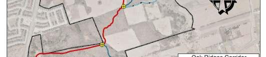
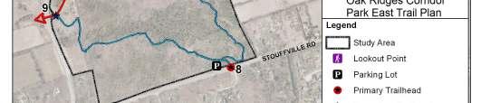
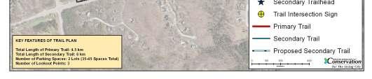
59 Map 6.1: Trail Plan, Oak Ridges Corridor Park East 54
60 7 Summary of Recommendations, Implementation Schedule and Budget It is anticipated that ORCPE will become a model of sustainability, achieved through protecting and enhancing the property s natural environment, while providing compatible nature-based recreational opportunities to the community through trails and community stewardship initiatives. It is therefore imperative that management of the property follow sound environmental management principles and collaboration with partner municipalities, interest groups and the local community. Implementation of the ORCPE Management Plan is estimated to cost $1.607 million over a period of 5 years. A detailed implementation plan, including phasing and costing is included in Appendix F. 7.1 Summary of Recommendations Management recommendations and actions for ORCPE are contained throughout Chapters 5 and 6 of this document. A condensed summary of these recommendations has been provided in Table 7.1 to highlight the key recommendations necessary for successful implementation the ORCPE Management Plan and realization the management plan vision. A complete summary of management recommendations and actions is provided in appendix G. 55
61 Table 7.1: Summary of Key Management Recommendations No. Key Management Recommendation ECOLOGICAL 1 Conduct regular inventory and monitoring of flora, fauna and overall condition of both the aquatic and terrestrial ecosystems. 2 Protect groundwater resources including seepage and recharge zones. 3 Monitor and manage invasive species. 4 Protect species of concern and enhance habitat opportunities for these species. 5 Restore habitat through wetland creation, habitat enhancements and reforestation. 6 Resolve longstanding sediment control issue in the southwest corner of the property. CULTURAL 7 Protect and conserve archaeological sites and explore opportunities to interpret these sites. SOCIAL 8 Establish a formal trail system that will protect the natural system while providing nature-based recreation opportunities. 9 Conduct regular property inventory and audit surveys to identify encroachments, unauthorized activities and safety concerns. 10 Establish a stewardship committee and trail captain program to engage local residents in the care of the property. 11 Maintain the fields south of Bethesda Sideroad for active agriculture or similar use (e.g. community gardens). INTEGRATION 12 Rename Oak Ridges Corridor Park East and Oak Ridges Corridor Park under a single overarching name, "Oak Ridges Corridor Conservation Reserve". 13 Develop an integrated implementation plan for projects proposed for the former Oak Ridges Corridor Park and Oak Ridges Corridor Park East. 7.2 Implementation Schedule The implementation of the ORCPE Management Plan will require the cooperation of TRCA, the ORCPE Stewardship Committee and other partners. Table 7.2 summarizes the major projects and costs for implementation that are identified in the plan. Implementation of the management plan will be led by various TRCA departments including Conservation Lands, Restoration Services, Ecology, Archaeology and Property Services. Day to day maintenance and site level operations at ORCPE will be conducted by TRCA s Conservation Parks department. Beyond completion of the implementation plan, the Conservation Lands and Property Services departments will continue to administer trail agreements with trail partners, conduct annual property audits, oversee the continuation of the stewardship committee, and manage the trail systems within ORCPE and Oak Ridges Corridor Park. 56
62 Table 7.2: ORCPE Management Plan Implementation Schedule Please refer to Appendix H for more details about implementation costs ITEM TRCA LEAD ANTICIPATED COST Immediate Erosion Site Mitigation Strategy Conservation Lands $50, Invasive Species Management Prioritization Plan Ecology $1, Detailed Trail Design Study Conservation Lands $10, Archaeological Survey of Spine Trail Corridor Archaeology $15, No Trespassing/ Dog Off-Leash Sign Installation Conservation Lands $1, Sub-Total $78, Years Forest Inventory Restoration Services $5, Swan Lake Aquatic Survey Ecology $10, Erosion Site Mitigation/ Habitat Restoration Conservation Lands $148, Reforestation Restoration Services $25, Archaeological Surveys and Reporting Archaeology $25, Primary Trail Construction Conservation Lands $525, Primary Trailhead Construction Conservation Lands $14, Design and Construction of 35 Car Parking Lot Conservation Lands $90, Regulatory Signage Installation Conservation Lands $2, Barrier Installation Conservation Lands $8, Fencing Installation Conservation Lands $24, Gate Installation/ Repair Conservation Lands $3, New Homeowner Information Package Conservation Lands $10, Sub-Total $889, Years Sandbarren Controlled Burn/ Mowing Regime Ecology $15, Secondary Trail Construction Conservation Lands $88, Secondary Trailhead Construction Conservation Lands $12, Lookout Nodes Construction Conservation Lands $12, Design and Construction of 15 Car Parking Lot Conservation Lands $65, Wayfinding Signage and Trail Post Marker Installation Conservation Lands $12, Interpretive Signage Development and Installation Conservation Lands $15, Trail Guide and Map Conservation Lands $10, Necessary Repairs/ Upgrades to Swan Lake Buildings Property Services $80, Sub-Total $310,
63 Ongoing (1-5 Years) Invasive Species Management Conservation Lands $55, Invasive Species Monitoring Conservation Lands $15, Extirpated Species Monitoring Ecology $10, Hazard Tree Removal Restoration Services $12, Decommission Informal Trails Conservation Lands $15, Property Audit Conservation Lands $15, Encroachment Removal Conservation Lands $13, Stewardship Committee Conservation Lands $13, Trail Captain Program Conservation Lands $10, Rambler Newsletter Production and Distribution Conservation Lands $25, Sub-Total $183, Implementation Total $1,461, Contingency (10%) $146, TOTAL 5-YEAR BUDGET $1,607, Partnership Opportunities Partnerships have been a key component in the development of the ORCPE Management Plan, and numerous organizations and individuals have been instrumental in assisting TRCA in this regard. Partners thus far have included, amongst others, the Town of Richmond Hill, the Regional Municipality of York, the Ministry of Natural Resources, Ontario Realty Corporation, Oak Ridges Moraine Foundations, Oak Ridges Moraine Land Trust, Oak Ridges Friends of the Environment, Oak Ridges Trail Association, Richmond Hill Naturalists, Jefferson Forest Residents Association, Rouge Park and the Humber Watershed Alliance. TRCA will continue to look to partnerships for assistance in achieving its objectives for ORCPE. Fostering existing partnership and building new ones will be essential for successful implementation of the Management Plan. Partners who are stakeholders in the property, and who have a mutual interest in providing nature-based recreation and healthy lifestyle opportunities include the Town of Richmond Hill and York Region. A continued collaborative relationship and cost-sharing among these partners over the long term will be important in realizing the recommendations of the management plan to the mutual benefit of all parties. The Town of Richmond Hill has expressed interest in several potential projects at ORCPE that will provide residents with active recreation and nature appreciation opportunities. Given the Town s focus on developing trails and recreation opportunities, the Town may wish to partner with TRCA on the development of trails, trailhead infrastructure and trail guides. 58
64 The scenic and natural splendor of ORCPE makes the property a destination point and potential tourism draw within Richmond Hill and York Region. The property s location within the Town is well suited to serve the recreational requirements of residents from across Richmond Hill, as well meet the needs of the future communities that are planned for the lands immediately bordering the property. The Official Plan for the Region of York, (2010) includes chapters on Sustainable Natural Environment, Healthy Communities and Economic Vitality. The policies in the Official Plan are intended to guide economic, environmental and community-building decisions affecting the use of land throughout the region. The Sustainable Natural Environment section of the plan contains policies that protect the Region s natural features and ecosystems, while the Healthy Communities section emphasizes the community as a balanced and diverse place to live, work, enjoy recreation and interact with others. The Official Plan for York Region provides an excellent platform for partnership between the Region and TRCA to protect the natural features of ORPC- East, while providing nature-based recreation. York Region has recently begun examining its role in coordinating a natural heritage trails system throughout the Region, and would therefore benefit from supporting the types of trail linkages proposed for ORCPE. York Region s Pedestrian and Cycling Master Plan (2008) is supportive of regional and interregional scale trail networks that provide opportunities for commuting as well as recreation. The primary spine trail that is proposed in the ORCPE Management Plan will form a section of the interregional Oak Ridges Trail, connecting ORCPE to one of the major interregional nature trail systems in Ontario. The Pedestrian and Cycling Municipal Partnership Program is a York Region funding program that exists to support the development and construction of regional scale trails within York Region. There is potential for TRCA to partner with York Region through this program to support the cost of constructing the proposed spine trail in ORCPE. ORCPE is also identified as part of the Regional Greenlands System, and can play a role in helping York Region achieve their targets for natural cover. TRCA is interested in promoting use of its conservation lands as part of a component of healthy living. As part of this wellness program, there is potential to partner with public health departments and other health promotion industries. TRCA will look to local businesses and fundraising as a source of funds to support the implementation of the management plan. TRCA will also seek to partner with local community service groups to assist with plan implementation. Additionally, it is TRCA s intent to establish a stewardship committee to assist in the long-term management of both the ORCPE, and Oak Ridges Corridor Park lands. There is potential for the continued involvement of such volunteers in activities such as planting, clean-ups, trail maintenance and ecological monitoring. Many of these activities are already undertaken as volunteer measures by local residents and the dedicated volunteers who have served on the management plan advisory committee. 59
65 The stewardship committee will also be a key group in raising awareness and funds for the ORCPE. 7.4 Stewardship Committee This plan contains a variety of detailed management recommendations that were established with the assistance and support of the management plan advisory committee. All of the recommendations are important management actions that will protect and improve ORCPE. An integral part of ORCPE management is the establishment of a working stewardship committee to oversee and participate in the management and implementation of the necessary and numerous plan objectives. The committee would assist with specific aspects such as trails, education and communications. It would also assist TRCA to implement site development, maintenance, environmental protection and restoration activities. Finally, the committee would assist in the monitoring of environmental and public use indicators and of plan implementation. The management plan recommendations provide a basic framework from which the stewardship committee can begin to operate. While the key recommendations are outlined here, it is anticipated that the committee will undertake a complete assessment of the management plan on a regular and ongoing basis and will establish a through priority list. The key directions for the stewardship committee include: Review the management plan and establish priority actions for implementation Implement a detailed trail plan and develop a trail guide for users Participate as a designated Trail Captain Develop and maintain a ORCPE newsletter and communications plan to raise awareness and inform surrounding communities about the area Educate private landowners in and around ORCPE regarding stewardship practices and Natural Neighbour initiatives Establish a list of volunteers willing to aid in a volunteer program Prepare and install natural and cultural heritage interpretive signs Assist TRCA in implementing the various stewardship programs including the Sustainable Neighbourhood Retrofit Action Plan (SNAP). Develop educational resources and tools for private landowners and visitors Monitor the trails for invasive plant species and prevent their spread through barriers and other eradication techniques Monitor the presence of noxious weeds and remove the as necessary Organize celebrations events to increase public awareness Assist TRCA in implementing the Terrestrial Natural Heritage Monitoring Program Secure financial and in-kind resources to undertake the work. 7.5 Agency and Municipal Stewardship The natural, cultural and recreational resources that exist in ORCPE provide benefits beyond the TRCA property boundaries; these resources extend into, and contribute to, 60
66 the surrounding local and regional landscape. Therefore, integration with the community was considered throughout the planning process. An effort was made to reflect the recommendations and opportunities identified in municipal and government agency documents so that support for and implementation of the management plan can be achieved. There is a great opportunity to connect the recommendations of the ORCPE management plan to municipal goals and objectives, and continued communication with the Town of Richmond Hill and the Regional Municipality of York will be crucial to finding shared opportunities and efficiencies for achieving the recommendations within this management plan. To support TRCA policies, municipalities and government agencies should be encouraged to have regard for the following recommendations when considering new community design: Protect, restore and enhance as many natural open spaces as possible to maintain terrestrial natural habitat connectivity and interior habitats. Create publicly accessible trail systems that will connect communities to the Town of Richmond Hill and other Regional municipalities such as the City of Vaughan, the Town of Markham and the Town of Whitchurch-Stouffville. Promote private land stewardship that increases awareness about best management practices and creates opportunities to engage landowners in protecting and enhancing the ORCPE and its valuable resources. 7.6 Private Land Stewardship ORCPE will provide opportunities for outdoor recreation, conservation education and nature appreciation to the surrounding communities. It will also provide many health benefits to the community. Adjacent landowners and users of the TRCA property can help to ensure that the surrounding landscape does not negatively impact the environmental quality of this unique natural area. One of the key recommendations of this management plan is the creation of a stewardship committee. This committee will be made up of representatives of local government, residents, community groups, business owners and other stakeholders. The role of the committee will be to assist in implementation where appropriate, such as in trail development, clean up activities, restoration or naturalization projects, etc. The committee can also help to encourage area residents to undertake the following actions in an effort to fulfill the goals and objectives of this management plan: Plant native species on adjacent lands instead of using exotic horticultural species, some of which may be invasive, such as Norway maple and goutweed. Leash pets on site to minimize disturbance to wildlife and pick up waste to prevent feces from entering watercourses after rainfall. Assist in promoting the TRCA s Natural Neighbours messaging. Promote and participate in TRCA s Sustainable Neighbourhood Retrofit Action Plan (SNAP). All priorities should be reviewed and re-evaluated in terms of their feasibility as needed. 61
67 7.7 Public Use Completion and implementation of the management plan recommendations is critical to ensure protection of the environment, appropriate public use and user safety. The management plan was developed through extensive consultation with the public and community partners, and the proposed plan implementation is fully supported. If realized, the Oak Ridges Corridor Park East Management Plan will help to enhance the experience of users, while ensuring environment protection is achieved. 7.8 Safety and Security Discussions will be held with police and other emergency service providers to identify their concerns and questions regarding accessing the ORCPE lands for patrol and emergency response purposes. Due to the land s natural character, many areas are inaccessible by conventional response vehicles, such as fire, ambulance and police vehicles. Special considerations are therefore required, including: A trail locator system, such as a series of way-finding post markers along the trails in order to locate and orient users. Geographic integration of the trail location system into the emergency response system of the fire, police and ambulance departments. A fully integrated map depicting all named trails and location of markers along each trail should be installed at all primary and secondary trailheads. An emergency response plan for ORCPE with involvement from local and neighbouring emergency service providers. 7.9 Endorsement and Maintenance of the Management Plan As a partnership between York Region, the Town of Richmond Hill, the Management Plan Public Advisory Committee and the community, this management plan required endorsement from a variety of groups. The public, local community and ORCPE users were informed and consulted through the process through newsletters, questionnaires, open houses and public meetings held for each phase of the master plan process. Their concerns, comments and suggestions were heard and integrated into the plan. The advisory committee brought many interests, issues and insights from the broader community to the forefront of the planning process, and their comments and suggestions were also integrated into this plan. TRCA and the newly formed stewardship committee will continue to work together towards implementing, maintaining and adapting the plan Plan Review and Amendment With the support of the ORCPE Stewardship Committee, the master plan will undergo a review every seven to ten years. If major revisions are necessary to reflect changing environmental, social or economic conditions, they will only be made after consultation 62
68 with the affected groups and individuals. Revisions of the plan will be consistent with the original stated vision, goals and objectives to protect the natural, recreational and educational values of the property. The management plan identifies management zones, with public trails detailed in the trail plan. Any additional uses proposed for these zones will be screened and assessed according to the Strategy for Public Use of Conservation Authority Lands (1995). The ORCPE stewardship committee will provide input on all such proposals. The screening process for specific public uses will ensure that all proposed uses, facilities and landscape changes are thoroughly examined and designed to minimize disruption and to protect, enhance or restore the natural values of this area. 63
69 Bibliography Banks P.B. and Bryant J.V Four-legged friend or foe? Dog walking displaces native birds from natural areas. Biology Letters 3: Available online at: [Accessed 8 January 2010] Boudrea, Claude and Pierre Lapine Joseph Bouchette. Dictionary of Canadian Biography Online, accessed online January 2010, e.php?biold=37382 Cadman, M.D., P.F.J. Eagles, and F.M. Helleiner, Atlas of Breeding Birds of Ontario. Federation of Ontario Naturalists, Long Point Bird Observatory. University of Waterloo Press, Waterloo, Ontario, Canada. Douglas, W.A.E Jean-Baptiste Boucheette, Dictionary of Canadian Biography Online, accessed January http//biographi.ca/ e.php?id_nbr=2282&pppseesid=ychzlgkvss Gutzwiller, K.J. and S.H. Anderson, Spatial extent of human-intrusion effects on subalpine bird distributions. Condor 101: Hoffman, and Richards, Soil survey of York County. Report number 19 of the Ontario soil survey, experimental farms service, Canadian Department of Agriculture and the Ontario Agricultural College. Available online at: [Accessed 19 November 2009]. Kilgour B Landscape and patch character as a determinant of occurrence of eighty selected bird species in the Toronto area. Report prepared for TRCA. Jacques- Whitford Ltd. MTRCA, The Watershed Plan. On file, Toronto and Region Conservation Authority. MTRCA, Environmentally Significant Areas Study. Toronto and Region Conservation Authority. MTRCA, The Greenspace Strategy. On file, Toronto and Region Conservation Authority. NHIC (Ontario Natural Heritage Information Centre) Natural Heritage Information Website. Available online at [Accessed 8 January 2010]. Nuzzo V.A Invasion pattern of the herb garlic mustard (Alliaria petiolata) in high quality forests. Biological Invasions 1: OMC, Heritage Resources in the Land Use Planning Process, Cultural Heritage and Archaeological Policies of the Ontario Provincial Policy Statement 2005, Info Sheet #2 Cultural Heritage Landscapes. Queen s Printer of Ontario. 64
70 OMMAH, Oak Ridges Moraine Conservation Plan. Ontario Ministry of Municipal Affairs and Housing. OMMAH, Greenbelt Plan. Ontario Ministry of Municipal Affairs and Housing. OMMAH, 2005a. Provincial Policy Statement. Ontario Ministry of Municipal Affairs and Housing. OMNR, 2000a. Provincially Significant Wilcox St. George Wetland Complex. Ontario Ministry of Natural Resources, Aurora District. OMNR, 2000b. Inventory of five areas of natural and scientific interest (ANSIs) on the Oak Ridges Moraine, Town of Richmond Hill, Ontario. Ontario Ministry of Natural Resources, Aurora District. Primack R.B, Miller-Rushing A.J., and Dharaneeswaran K Changes in the flora of Thoreau s Concord. Biological Conservation 142: Rayburn, Alan Place Names of Ontario. University of Toronto Press Regal Heights Residents Association Area History Settlement Begins, accessed January 2010, Rosenburg, K.V., R.W. Rohrbaugh, Jr., S.E. Barker, J.D. Lowe, R.S. Hames and A.A. Dhondt, A land manager s guide to improving habitat for scarlet tanagers and other forest-interior birds. The Cornell Lab of Ornithology. Stamp, Robert M Early Days in Richmond Hill, A History of the Community to 1930, The European Settlers Arrive French Aristocracy in the Highlands of York, pages 1-5, electronic edition Town of Richmond Hill, Official Plan. Town of Richmond Hill. TRCA, An Archaeological Master Plan for the Toronto and Region Conservation Authority. Toronto and Region Conservation Authority. TRCA, Rouge Park Management Plan. Toronto and Region Conservation Authority. TRCA, 1994a. The Environmentally Significant Areas Update Program. Toronto and Region Conservation Authority. TRCA, 1994b. Valley and Stream Corridor Management Program Toronto and Region Conservation Authority. TRCA, The Strategy for Public Use of Conservation Authority Lands. Toronto and Region Conservation Authority. TRCA, The Watershed Plan Update. On file, Toronto and Region Conservation Authority. 65
71 TRCA, The Living City Region A Strategic Vision for the New Millennium Towards a New. Toronto and Region Conservation Authority. TRCA, Rouge North Management Plan. Toronto and Region Conservation Authority. TRCA, 2001a.Toronto and Region Conservation Authority Business Plan. Toronto and Region Conservation Authority. TRCA, Greenlands Acquisition Project. Toronto and Region Conservation Authority. TRCA, Little Rouge Corridor Management Plan. Toronto and Region Conservation Authority. TRCA, The Terrestrial Natural Heritage System Strategy. Toronto and Region Conservation Authority. TRCA, 2007a. Rouge River State of the Watershed Report. Toronto and Region Conservation Authority. TRCA, 2007b. Setting Terrestrial Natural Heritage System Targets. Toronto and Region Conservation Authority. TRCA, 2007c. Terrestrial Natural Heritage Program Data Collection Methodology. Toronto and Region Conservation Authority. TRCA, Humber River Watershed Plan: Pathways to a Healthy Humber. Toronto and Region Conservation Authority. TRCA, 2008a. Rouge River Watershed Plan Towards a Healthy and Sustainable Future. Toronto and Region Conservation Authority. TRCA, 2008b. State of the Humber Watershed Report. Toronto and Region Conservation Authority. TRCA 2008c. Dog-strangling vine Cyanchuym rossicum (Kleopow) Borhidi: a review of distribution, ecology and control of this invasive plant. Toronto and Region Conservation Authority and Rouge Park. TRCA Vegetation Community and Species Ranking and Scoring Method. Toronto and Region Conservation Authority. Watchorn M.A., Hamilton P.B., Anderson T.W., Roe H.M. and Patterson R.T Diatoms and pollen as indicators of water quality and land-use change: a case study from the Oak Ridges Moraine, Southern Ontario, Canada. J Paleolimnology 39:
72 Willis K.J. and Birks H.J.B What is natural? the need for a long term perspective in biodiversity conservation. Science 314: York Region, Region of York Official Plan. York Region Young, Brian J Forsyth, James Bell, Dictionary of Canadian Biography Online, accessed January 2010, ephp&id_nbr=4430&&phpseesid=ychzfgk 67
73 Appendices 68
74 Appendix A: Natural Heritage Maps 69


75 Map A.1: Habitat Patch Size with Fauna, Oak Ridges Corridor Park East 70


76 Map A.2: Interior Forest, Oak Ridges Corridor Park East 71

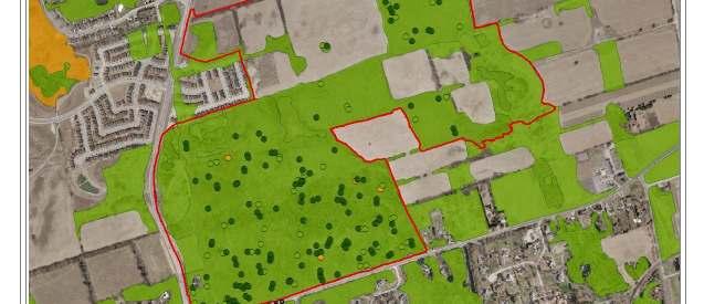
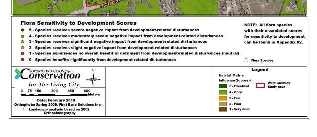
77 Map A.3: Matrix and Flora Sensitivity, Oak Ridges Corridor Park East 72

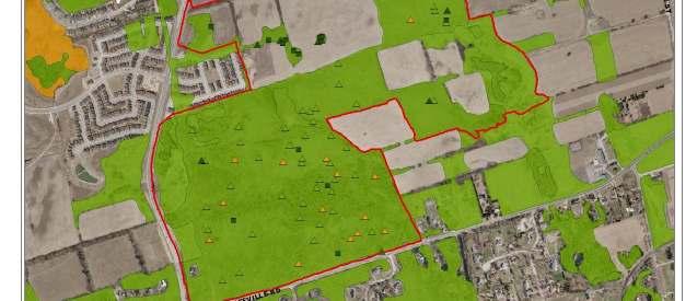
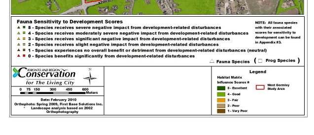
78 Map A.4: Matrix and Fauna Sensitivity, Oak Ridges Corridor Park East 73


79 Map A.5: Habitat Patch Quality, Oak Ridges Corridor Park East 74


80 Map A.6: Vegetation Communities and their Associated Local Ranks, Oak Ridges Corridor Park East 75

81 Map A.7: Flora Species of Concern, Oak Ridges Corridor Park East 76


82 Map A.8: Fauna Species of Concern, Oak Ridges Corridor Park East 77
83 Appendix B: Management Zone Planning Maps 78
84 Map B.1: Existing Conditions Scenario, Oak Ridges Corridor Park East 79

85 Map B.2: Build Out Scenario, Oak Ridges Corridor Park East 80
86 Map B.3: Build Out and Restoration Scenario, Oak Ridges Corridor Park East 81

87 Map B.4: Impact Analysis, Oak Ridges Corridor Park East 82
88 Appendix C: Restoration Maps 83

89 Map C.1: Proposed Planting Areas, Oak Ridges Corridor Park East 84

90 Map C.2: Habitat Opportunities, Oak Ridges Corridor Park East 85
91 Appendix D: Watershed Plan Targets Table D.1: Humber River Watershed Plan: Selected Targets and Oak Ridges Corridor Park East Management Plan Contributions (TRCA, 2008) Component Objective Indicator Target ORCPE contribution Aquatic System Protect, restore and enhance the health and diversity of native aquatic habitats, communities and species Benthic Invertebrates Fish Communities Minimum of 70% of RWMP sites rated as fair or good based on benthic invertebrate indices All RWMP sites upstream of urban development rated as good based on Index of Biotic Integrity (IBI) scores Protection of aquatic habitat, communities and species through management recommendations and actions RWMP sites in urban areas should maintain or improve baseline conditions (see TRCA, 2008) Maintain or restore target fish communities (see TRCA, 2008) 86
92 Terrestrial System Protect, restore and enhance natural cover to improve connectivity, quality, biodiversity, and ecological function Minimize the negative influences from surrounding land uses on terrestrial system quality and function Aquatic Habitat Increase wetland cover to 10% of total watershed area Greater than 75% of riparian areas with natural cover (60% forest or succession; 15% meadow or wetland) Quantity of natural cover Increase natural cover to at least 39% of total watershed area (see TRCA, 2008) Quality and distribution of natural cover Increase wetland cover to 10% of total watershed area Average habitat patch total quality rating of good for all patches in, or partially within, the watershed (see TRCA, 2008); and good for the Main Humber primary subwatershed Disturbances in natural areas Maintain or reduce baseline ratios of severely disturbed area to total evaluated areas (see TRCA, 2008) 87 Protection, restoration and enhancement of wetlands and riparian areas through management recommendations and Actions 75 ha of natural cover to be created through restoration, in the following categories: 78% forest, 1% meadow, 14% riparian, 7% wetland 75 ha of natural cover to be added through restoration Approximately 5 ha of wetland to be added through restoration Current average patch quality of good will be maintained, despite increased pressures from surrounding development, through restoration of damaged areas and agricultural fields 23 ha of severely disturbed area to be restored to natural cover
93 Cultural Heritage Nature-based recreation Identify, document, protect and conserve cultural and heritage resources Incorporate greenspace in all urban and rural developments and create an accessible and connected greenspace system that is compatible with ecological and cultural integrity Develop a system of inter-regional trails, and local and regional nature-based recreation, education and tourism destinations within the greenspace system Biological diversity Maintain or improve baseline representation of native vegetation community types and species (baseline to be determined through RWMP natural heritage inventories) Cultural heritage resources Quantity of public greenspace Increase number of known, Listed and Designated archaeological and historical sites and built heritage features (see TRCA, 2008) Increase quantity of public greenspace (see TRCA, 2008) Public greenspace is located within 2 km of all homes Management of public greenspace Manage 100% of public greenspace through application of standards of best practice Trails An additional 60 km of interregional trails are built in the watershed (see TRCA, 2008 and TRCA, 2008) Increase connectivity between inter-regional and local trails 88 Maintain or improve representation of native vegetation community type and species through management recommendations and actions Increase number of sites and features through management recommendations and actions Currently 175 ha of greenspace protected; approximately 12 ha of additional greenspace targeted for acquisition All new homes that will be constructed in planned development areas will meet 2 km proximity target to greenspace 100% of ORCPE will be managed through application of standards of best practice 10 km of trails will be built, including 4 km of interregional trails (Oak Ridges Trail)
94 Nature-based recreation, education and tourism destinations Provide opportunities for naturebased recreation experiences related to following concept areas or themes: - Kettle lakes - Hills of the headwaters 89 Trails will provide naturebased recreation opportunities in both concept areas, including interpretive signage.
95 Table D.2: Rouge River Watershed Plan: Selected Targets and Oak Ridges Corridor Park East Management Plan Contributions Component Objective Indicator Target ORCPE Contribution Aquatic System Protect, restore and enhance the health and diversity of native aquatic habitats, communities and species. Terrestrial System Protect, restore and enhance natural cover to improve connectivity, Fish Monitoring stations upstream of urban development should reflect healthy aquatic habitats and be reflected in the IBI Score. Stations within the urban boundary should maintain or improve existing conditions (TRCA, 2007) Aquatic Habitat Increase wetland cover Features to 10% of total Quantity of natural cover watershed area For areas of low impervious cover, target 80% riparian zone treed, 20% of riparian zone other natural cover Increase natural cover to at least 31% of the watershed Protection of aquatic habitat, communities and species through management recommendations and actions 58 ha of forested area to be added, 16 ha of other natural cover categories, through restoration 75 ha of natural cover to be added through restoration 90
96 biodiversity and ecological function. Protect, restore and enhance the terrestrial natural heritage system quality and function to minimize the negative influences of surrounding land use. Distribution of Quality Improve the distribution of quality habitat patches in the Upper Rouge/Beaver Creek subwatershed to 9.9 (fair) Disturbances in natural areas Maintain or reduce the ratio of severely disturbed areas to total ELC area (baseline as per Rouge River State of the Watershed Report, TRCA, 2007) Quality of natural cover Average total quality score of 10.8 for the Rouge River watershed 91 Current average patch quality of good will be maintained, despite increased pressures from surrounding development, through restoration of damaged areas and agricultural fields 23 ha of severely disturbed area to be restored to natural cover Current average patch quality of good will be maintained, despite increased pressures from surrounding development, through restoration of damaged areas and agricultural fields
97 Increase native terrestrial biodiversity Cultural Heritage Identify, document, protect and celebrate cultural heritage resources. Nature-based Recreation Ensure that recreation activities in the watershed are compatible with ecological and cultural integrity. Provide opportunities for a variety of appropriate public uses and experiences in representative natural and cultural landscapes. Biodiversity Enhance and expand native habitat and species type representation in the terrestrial system (baseline as per the Rouge River State of the Watershed Report, Cultural heritage resources Disturbance in natural areas Variety of uses and experiences TRCA, 2007) Increase the database of known archaeological, historic and burial sites, and built structures (baseline as per Rouge River State of the Watershed Report, TRCA, 2007) Maintain or reduce the ratio of severely disturbed areas to total ELC area (baseline as per Rouge River State of the Watershed Report, TRCA, 2007) Protect and enhance key uses and experiences in representative areas (e.g. bird watching, hiking, cross-country skiing, snowshoeing, cycling) 92 Maintain or improve representation of native vegetation community type and species through management recommendations and actions Increase number of sites and features through management recommendations and actions 23 ha of severely disturbed area to be restored to natural cover Nature-based recreation opportunities to be provided (hiking, crosscountry skiing, snowshoeing, cycling, bird watching) through trail network
98 Develop a continuous trail network linking Lake Ontario to the Oak Ridges Moraine, with connections to local communities, neighbouring watershed trail systems and natural and cultural heritage features. Access to greenspace Greenspace located within 2 km of all homes Maintain or increase the number of hectares of greenspace per 1,000 residents (baseline as per Rouge River State of the Watershed Report, TRCA, 2007) Trails 100% completion of planned trail systems (as per figure 5-3 Rouge River Watershed Plan, TRCA, 2007) All trails to be surveyed and posted by Universal Trail Assessment Process. Connectivity 100% of planned trail linkages (as per figure 5-3 Rouge River Watershed Plan, TRCA, 2007) 93 All new homes that will be constructed in planned development areas will meet 2 km proximity target to greenspace Currently 175 ha of greenspace protected; approximately 12 ha of additional greenspace targeted for acquisition 100% completion of trail system, will result in additional 10 km of formal trail. All trails to be surveyed and posted 100% completion of trail linkages, will result in additional 10 km of formal trail.
99 Appendix E: Trail Design and Management 1 Trail Design Standards 1.1 Terminology and Definitions The profile of a typical trail shows the basic components that compromise the user zone for any trail type (see Table F1). Table E.1: Definitions of Basic Trail Components TRAIL COMPONENT DESCRIPTION Clearing Width Clearing Height Tread Width Tread Drainage Clearing Limits The dimension measured across the trail from which all vegetation, rocks or other obstructions are removed so as not to obstruct movement along the trail. The vertical dimension that must be cleared of all branches that would otherwise obstruct movement along the trail. The horizontal dimension across the trail that provides adequate space for comfortable and safe movement. The traveled portion of the trail right-of-way (ROW) typically sloped or crowned to shed water. Provision of methods to manage excessive water runoff (ditch, dip, culvert, French drain, etc.). Point at which the disturbance to the natural environment is limited. Defines the trail ROW. 1.2 Trail Standards TRCA s Trail Planning & Design Guidelines: A Handbook for an Inter-Regional Trail System in the Greater Toronto Area (1992) provides trail standards and guidelines for the development of trails at ORCPE. This document was in the process of being updated at the time the ORCPE Management Plan was printed. Trail design and construction should be carried out according to the most up-to-date guidelines and standards. The following are the general design standards and guidelines for each of the trails. (Note: These are general standards and are not intended for construction. Each trail should be designed based on its type, level of use and specific site conditions.) Primary Trail (multiple users) The primary trails at ORCPE will be built to the multi-use trail design standards of TRCA. General Design Standards Minimum 94
 The secondary trails at ORCPE will be built to the hiking trail design standards of TRCA (see Figure E.")
100 Clearing Width: metres Clearing Height: 3.0 metres Tread Width: metres Tread Surface:...compacted stone fines Desirable Grades:.0-3% Maximum Sustained Grade: 6% Form:..linear, loop, stacked loop, and satellite loop Secondary trail (hiking) The secondary trails at ORCPE will be built to the hiking trail design standards of TRCA (see Figure E.1). Figure E.1: Trail Design Standards for Hiking Trails General Design Standards Minimum Clearing Width:...1 metre Clearing Height: 2.5 metres Tread Width: metres Tread Surface:...natural terrain Desirable Grades:.0-20% Maximum Sustained Grade: 25% Form:..linear or loop Minimum trail standards for a hiking trail provided for a low to moderate level of use is a cleared ROW with minimum grubbing and no special tread surface (i.e., a natural trail). 95
101 Although multi-use trails generally allow for a natural system of habitat patches, trails may contribute to a reduction in the quality of the natural system. Therefore, careful trail planning, including decommissioning trails which are inappropriately located, is recommended to protect the numerous sensitive areas at ORCPE. 2 Trail Impacts and Mitigation Techniques The major sources of disturbance to the environment include clearing of the trail route, human contact with wildlife, soil erosion, trail side trampling and shortcutting. Key potential causes of disturbance and their recommended mitigation methods are listed below. 2.1 Clearing the Trail Route Clearing the trail refers to the actual creation of a trail according to the above-noted trail design standards. It may also refer to amendments and repairs to existing trails. Correctly routing the trail and implementing trail construction and clearing will help eliminate many of the potential impacts caused by clearing. Of course, clearing by its very nature will always result in some impact, but the type and extent of impact can be controlled through careful planning, design and implementation. Recommendations Route the trail to avoid important ecological elements, cultural features, rare plants and important habitat zones. Strictly control the limit of disturbance to within the defined ROW zone. 2.2 Human Contact Wildlife species and plant communities have different environmental levels of tolerance to human activity that could result in abandonment of habitats or ecological imbalances. As a result, trail routing and accompanying signage should focus on preventing disturbance to sensitive or rare species through avoidance of associated habitats. Education and proactive approaches such as signage and positive interpretation can also help ensure that interactions between humans and wildlife within the ORCPE are positive. Recommendations Ensure that detailed trail routing is conducted both on site and using detailed natural heritage mapping to route trails appropriately for species of concern, interior forest, ESAs and other natural features. Erect signage and provide interpretive sites along the trail to encourage viewing opportunities that are safe for both humans and wildlife and minimize the potential negative impacts of human contact with wildlife. Decommission trails that currently travel through ecologically sensitive areas, including interior forest habitat and other areas deemed ecologically sensitive through the natural heritage approach. Apply all of the above recommendations to aquatic as well as terrestrial habitats within the ORCPE. 96
102 2.3 Environmental Impacts Created by Overuse Environmental impacts caused by overuse can include trampled vegetation, slope erosion, soil compaction, increased root exposure and trail widening around wet areas. These impacts can negatively affect the surrounding natural area and features over time. The result is a spreading, compacted trail system that not only affects the ecological quality of the surroundings, but also negatively affects the user experience. Recommendations Avoid important habitat zones. Favour the natural environment where there is a question regarding specific impacts. Locate activities for large groups and noisy recreational activities metres away from ESAs. Avoid the use of large-scale equipment for construction and schedule construction operations at times that do not conflict with critical phases of seasonal wildlife. Provide limited access to sensitive habitat areas through small tributary trails and then only when kept to an acceptable level as determined by qualified TRCA staff, or discourage completely. Develop viewing stations to allow visitors to view sensitive areas from suitable distances. Control use by turning tributary trails into dead ends to minimize flow-through circulation. Design tributary trails to be suitably difficult to encourage only serious users. Lessen trail width and, where applicable, downgrade the trail surface. This will provide an immediate message to the user. Monitor trail condition throughout the year and relocate trails as required. Restrict access to specific areas during critical seasons of the year and, where necessary, close trails during spring melt or other significant weather events to prevent damage and reduce risk to human safety. 2.4 Soil Erosion Erosion is the natural process through which soil and rock are worn away by wind and water. Trail erosion can be accelerated by a combination of users, water and gravity. When left unmitigated, erosion can destroy a trail and damage the surrounding environment (IMBA, 2004). Erosion affects functional utility, safety, ecological balance and aesthetics. The effects include loss of topsoil, root exposure, stream sedimentation, contaminations of water supplies, and slides and slumping. Erosion is caused by erosion-susceptible soils (especially when wet), excessive removal of vegetation, excessive compaction due to trampling, uncontrolled surface runoff, and improper installation of bridges and culverts. Erosion is often a problem on steep grades. When runoff water concentrates, it cuts into the soil. This forms single or numerous channels referred to as gullies. The development of gullies is common on steep slopes where there is concentrated water runoff (IMBA, 2004). 97
103 Recommendations Locate trails where soils are most resistant to erosion. Use tread surfacing or bridging to protect soil. Provide dry walking surfaces in wet areas or poor soil conditions, particularly in groundwater discharge areas. Ensure proper control of drainage on sloping trail sections by use of grade reversals, drainage dips or culverts. Cross-slope the tread in the direction of the natural grade. For areas in and out of a valley only, locate trails diagonally across slopes rather than directly down the face (fall-line) of a slope, at an angle that will sufficiently lower the trail grade to a suitable level. For low use hiking trails, incorporate natural trail dips into the trail surface to divert drainage at frequent intervals of metres. Use switchbacks on steep slopes to maintain optimum grades. Slope cross section of tread a minimum of 2% to direct small amounts of water across the trail surface. Intercept excessive runoff with ditches and a central crown and provide periodic crossings of culverts to minimize runoff build-up. Maintain vegetation as close to the trail edge as possible to stabilize soil and encourage percolation of water into the soil. Ensure proper siting and design of culverts and bridges to provide for adequate peak drainage flows. Minimize disturbance to streambeds and banks; locate on straight sections of streams parallel to flow. Construct bridges, as they are more suitable than culverts for large streams. 2.5 Trail-Side Trampling Damage to vegetation and soils occur when users wander off trails. This happens due to overly narrow trails, overuse, ill-defined trail edges and difficult or unsafe trails (muddy, eroded, blocked, subject to mud slide, etc.). Recommendations Provide trail widths that can accommodate expected traffic volume based on design standards. Provide widenings where people are likely to gather (viewing points, features of interest, interpretive displays, etc.). Raise the trail tread by using boardwalks. Restrict use to optimum levels through management controls such as signage or temporary closures. Perform frequent checks to ensure that deadfalls do not block or obscure trails. Use logs, branches and rocks to mark trail edges wherever problems occur in keeping users on trails. Designate travel routes for maintenance vehicles within the ORCPE. Keep vehicles off sensitive terrain and non-designated routes. Consider applying special tread surfaces to routes designated for maintenance or emergency vehicle access to reduce compaction and erosion problems. 98
104 2.6 Shortcutting Damage to vegetation and soils occur when users wander off trails. This happens if trails are too difficult or unsafe, if the user is attracted to an interesting feature off trail, or if an easier route is visible. Recommendations Use natural features such as land form and vegetation to block or screen potential shortcut routes. Placing rocks or planting shrubs provides a suitable natural deterrent. Restrict construction of switchbacks to only the most essential circumstances as these provide ample opportunity for shortcutting and will generally require numerous introduced deterrents such as planting or rock placement. Locate switchbacks with dense vegetation or rough ground between to eliminate the need for constructed barriers. Build in rough steps with boulders or logs on switchbacks to channel shortcutting traffic along a predetermined route. 3 Trail Construction In addition to the impact yielded by on-going use, the actual trail construction process results in various impacts to the environment. These can include pruning, removal of vegetation and soil compaction caused by construction machinery traveling repeatedly over the same access route. Great care must be taken to control direct and indirect impacts during the construction process. Work done on existing and new trails should be completed to minimize the amount of disturbance to the site. 3.1 Timing Timing of construction is important. Recommendations Avoid construction during wet/rainy periods and nesting/breeding seasons to minimize impact. 3.2 Clearing The clearing operation refers to cutting of trees and to removing all materials that may obstruct movement along the trail, thus creating a potential hazard. Prior to clearing, a tree impact assessment will be completed to describe the trees, numbers, species, condition and location. The assessment will ensure appropriate trail routing with acceptable environmental impact. Large trees will be felled and stumps will be cut off flush, or preferably below grade, and removed completely from the trail. Complete flushto-grade clearing will generally occur on the tread surface, while the rest of the cleared right-of-way (ROW) will only see the removal of trees and large shrubs. Smaller shrubs and groundcover will remain. Recommendations 99
105 All natural wastes should be removed from the site and disposed of properly. Natural materials can be left on site but spread out so as not to cause a fire hazard. 3.3 Surfacing The existing grade should not be unnecessarily disturbed to obtain a trail base, especially on flat, solid ground. Minimum disturbance will provide the best natural aesthetic for the final product. When native soil is not a suitable tread surface to carry a specific user or does not provide adequate support, special tread surfaces can be provided. The surfaces should provide an appropriate level of comfort and safety for the user and should be constructed to blend in with the surrounding environment. A mulch-type surface (bark/wood chips) is attractive and compatible with the natural environment, but does not compact well. It is therefore not suitable for heavy-use foot traffic, or multi-use trails. Recommendations Wood chips should be placed on the trail in sections where root exposure is extreme or drainage is a slight problem. Where wood chips are required they should be laid down the width of the tread at a depth of millimetres. Chips should be no larger than 50 millimetres by 10 millimetres thick. Subgrade preparation is generally not required for this application. 3.4 Boardwalks The boardwalks should be constructed on site. Generally, the construction involves untreated timber and planking fixed on timber posts, large flat rocks or concrete piles. A variety of configurations are possible depending on whether the boardwalk is a simple walkway or a lookout platform, and whether it overhangs a slope or a water body. Boardwalk construction should consider the level of use and the potential for vandalism, and should be constructed to withstand both as best as possible. The construction technique for a particular application should conform to local building codes. Recommendations Where drainage becomes a safety concern, boardwalks should be used. A detailed site assessment should be conducted prior to construction. 3.5 Barriers Barriers can be constructed from a variety of materials including rock, timber or steel. Care should be taken to choose a material and appropriate barrier to meet safety requirements while still being able to blend into the natural landscape. Green barriers may also be suitable in certain situations (i.e. hawthorn, raspberry bushes, etc.). Recommendations Careful assessments of all potential barrier sites should be conducted prior to constructing or establishing any barrier. 100
106 4 Trail Management Environmental concerns identified in this study include the need for trail rehabilitation and/or closure. Measures such as the rerouting of trails, trail edge definition and structures will help to protect sensitive areas. 4.1 User Management Trail operation involves managing the type, volume and season of trail use to achieve the goal and objectives for trail development and management. The elements of user management include monitoring volume of use, type of use and effects of use on the trail management objectives; implementing trail restrictions; and informing users through newsletters, brochures, maps and signs of the types and levels of use intended for the trail. 4.2 Managing Trail Use Restricted use may be necessary on trails where there is concern for safety, significant conflicts, unacceptable resource damage or when operation and maintenance costs are excessive due to overuse, type of user or seasonal conditions. The trails should be actively monitored and closed as required to protect the environment. In the case where trails are to be decommissioned, several practices can be adopted: Frequent patrolling of trail by maintenance and/or security staff or responsible user groups. Remove trail signage or interpretive posts; remove bridges or other access features; allow natural regeneration of the trail; erect barriers (plantings, fences, gates or natural stone blocks); erect positive signage describing the reasons for the closure; and where possible describe nearby alternatives. The decommissioning of trails, especially well established, long-term trails, can result in negative reactions from user groups. For this reason, it is important that the process be open and involves public outreach and education. A key group to assist in this work will be the stewardship committee, along with local hiking, cycling or trail groups. In cases where trail uses are to be restricted, such as restricting bicycle use while permitting pedestrian use, providing barriers may help restrict the former while allowing the latter access. The decision to erect barriers, in addition to signage in this instance should be carefully considered and analyzed, and any barriers erected must be frequently monitored to ensure that the barrier is successful. In this instance, monitoring will involve determining whether or not the undesired use is in fact being restricted, or whether users are simply creating new trails or access areas. Advisory restrictions include posting of notices to warn users of ongoing maintenance works, fallen trees or other natural conditions that potentially restrict trail use. Positive signage communicates a good host image and explains why a particular behaviour is requested. Negative signage should be avoided. Community involvement and support for prohibitions prior to taking action will help in enforcing restrictions. Notices of restrictions should be shown on maps as well as newsletters and trail guides. 101
107 5 Maintenance A well-designed and constructed trail system is the foundation for many enjoyable years of walking, hiking and cycling. To keep the trails safe, functional and attractive through the years, a routine maintenance program is necessary. Maintenance should be carried out on a regular basis by TRCA staff with the help of the stewardship group to prevent the trails from falling into disrepair. 5.1 Surface Treatment The material on top of the trailbed can provide the desired tread, thereby minimizing the impact of the user on the trailbed and surrounding flora. The three most important factors to consider when providing a special tread surface are firmness, evenness and dryness. Surface treatments can be used to lessen the compaction of soil, provide a dry surface for users, and prevent potential erosion and abrasion. Trails can be surfaced with asphalt, a boardwalk, dirt, rock, gravel, sand, mud, snow, grass and other substances, depending on the user group and their needs (IMBA, 2004; TRCA, 1992). A firmer tread and even grades are generally required on trails traveled by bicycles, those with mobility needs and for persons using wheelchairs. Strength of the tread and the underlying soil becomes a factor on trails traveled by maintenance vehicles (TRCA, 1992). Recommendations Fill low spots with native soil, granular material or woodchip mulch. Where root exposure is hazardous, cover with mulch to protect the roots from further damage. 5.2 Erosion Erosion affects functional utility, safety, ecological balance and aesthetics. Minimizing and mitigating erosion is important to keeping the trails at ORCPE in good working order. Recommendations Monitor trails for erosion damage. Fill channels eroded through trails with appropriate compacted material. Give prompt attention to serious damage while diverting trail traffic for safety reasons. During periods of snow melt or heavy rainfall, such as in spring and fall, close certain trails to minimize damage to trails and risk to human safety. 5.3 Pruning and Trimming All pruning and trimming of trees along trail routes shall be subject to the standards and guidelines established in TRCA s Policy for Managing Hazard Trees and the associated Operational Procedures for Managing Hazard Trees. Recommendations Remove major limbs or trees adjacent to the trail that are in poor condition. 102
108 Remove branches, limbs and any other debris on the trail tread. These can be piled to encourage wildlife use or used as trail edges. Using pruners or loppers, prune back branches leaning into the trail ROW and prune off at ground level any woody sapling growth in the ROW. Conduct sensitive vegetation control on a semi-regular basis. This is necessary to ensure that the path is not crowded or blocked while maintaining natural character along the path edge. 5.4 Windfalls/Hazard Tree Removal Hazard tree removal along trail routes shall be subject to the standards and guidelines established in TRCA s Policy for Managing Hazard Trees and the associated Operational Procedures for Managing Hazard Trees. Recommendations Monitor trails for fallen trees, limbs and debris, and coordinate their removal as soon as possible. If material cannot be removed immediately, eliminate dangerous hanging branches and trunks or leaners. Cut a path through fallen tree debris to allow user thoroughfare and leave remainder in place. Extra debris in the ROW may be cleaned up at a later date. Leave in place tree trunks that have fallen over pedestrian trails, with the exception of the section of the tree blocking the clearing width of the trail, which will be cut and removed to allow pedestrians to cross. Redirect trail users during the clearance work or close the trail to ensure user safety. Remove debris entirely in trailhead areas. In natural areas, the trunk and debris may be left to encourage wildlife use, but they should be deposited out of sight from the trail. Ensure the trail is returned to its intended condition after completion of maintenance. This may involve repairs to the trail surface. 5.5 Structures Trail structures may include bridges, drainage structures, raised trails, stairways, retaining walls and barriers. The first consideration of providing a trail structure is to actually determine the need. Structures are expensive and should only be used where they are essential to retain the level of comfort and safety on the trail. The type of structure should be designed to reflect the natural surroundings. As a general rule, natural materials are best, and if possible, local materials should be used (TRCA, 1992). Recommendations Inspect all structures for safety and stability on a yearly basis. A monthly check is also useful for preventing major damage or accident. Monitor boardwalk decking and support members on a regular basis. Replace broken or rotting wood immediately. 103
109 5.6 Signage Trail signs enhance the trail experience and provide guidance to the user. There are four major functional types of signs: identification, directional, regulatory and interpretive (please refer to TRCA s Trail Planning & Design Guidelines for more detail). All signs should be placed so that they face the anticipated direction of traffic, are unobstructed by vegetation and are easy to read and understand. Signs should be mounted at a height appropriate to the specific user (TRCA, 1992). Recommendations Check to ensure that signs have not been removed or repositioned. Replace missing signs as soon as possible, even if a temporary sign is required. Replace or repair damaged signs as soon as possible to maintain trail quality and direction. Evaluate signage on a regular, yearly basis to maintain finish and message quality. Straighten and secure posts. Install seasonal signs with appropriate sign posts. Remove them promptly when their message is no longer appropriate or necessary. 6 Monitoring and Management Systems An operations system is required to plan, schedule, perform and evaluate maintenance activities. The following guidelines outline the development of such a system. TRCA should encourage user groups to actively participate with the Trail Implementation Sub- Committee in this program. 1. Establish Maintenance Objectives These may vary from trail to trail depending on traffic flow or special trail features such as ESAs. The major objectives will include: (1) ensuring user safety and (2) maintaining the trail and its amenities at a level consistent with the design and planning standards. This may also involve undertaking seasonal trail closures if deemed appropriate through monitoring. 2. Evaluate Trail Needs This process of making lists of maintenance tasks and seasonal requirements would be required to satisfy the maintenance objectives. It may be determined that certain trails will require closure or seasonal signage as a part of this evaluation of trail needs. These would prevent safety hazards and negative impacts on the trail and surrounding ecosystem due to inappropriate use during certain times of the year (i.e., washouts due to rain or snowmelt). 3. Develop a Maintenance Program Condense the maintenance tasks and seasonal requirements into a preliminary schedule. Use this schedule to determine the number of crews required to complete the program and the number of staff per crew. With this information, an initial inventory of hand equipment and power equipment, including motor vehicles, can be determined. Of course, the maintenance budget becomes a factor in all these decisions. 4. Establish a Trail Monitoring System To facilitate prompt repairs along a trail system or to determine if a trail needs additional seasonal maintenance, trails must be monitored regularly. This involves a thorough 104
110 inspection of the trails, reporting all deficiencies and their location in a log format. Specific tasks can be assigned a code number for ease of reference and execution by staff. 5. Schedule and Record Maintenance Regular maintenance can be scheduled on a yearly basis. This forms the basic structure of the maintenance program for which labour and equipment can be allocated. However, special maintenance (such as windfalls or vandalism, which are unplanned occurrences) must also be given attention during scheduling. Schedules will become the basis for work orders. As the work orders are completed by staff on the trails, work reports should be kept detailing the tasks completed, time required and work conditions (such as sun, rain, brush, bog, etc.). These work reports should be filed according to each particular trail and can be used to develop activity summary sheets or work standards. Activity summaries should be reviewed every two to three years to ensure that they conform to the work on the trails. The summaries can be used to evaluate efficiency or work crews and create time-efficient maintenance schedules. 6. Maintenance Evaluation The trail logs and work reports should be reviewed on an annual basis, if not more frequently, to determine excessive trail use, vandalism, damage and environmental degradation. This information must be communicated to trail planning and routing authorities so that they can reassess the trail routes. This evaluation may result in trail closures, upscaling, downscaling or re-routing. 105
111 Appendix F: Site Securement and Protection Plan Note: The Site Securement and Protection Plan was completed in 2007 as a pre-cursor to the management plan, and does not contain the Swan Lake or Klees property acquisitions. 106
112 BACKGROUND Oak Ridges Corridor Park East (ORCPE) is approximately 180 hectares of land that straddles the boundary between the Humber River and Rouge River watersheds. It is located between Bethesda Sideroad and Stouffville Road to the north and south, and between Bayview Avenue and Leslie Street to the east and west. It is immediately south of the Lake St. George Field Centre and east of the Oak Ridges Moraine Corridor Park. ORCPE is located in the Town of Richmond Hill, in the Region of York. It consists of forest and successional forest areas, wetlands and meadows. It provides quality habitat in both the Humber River and Rouge River watersheds, as evidenced by the variety of flora and fauna species of regional concern. The property is subject to several provincial plans and policies, including the Oak Ridges Moraine Conservation Plan and the Greenbelt Plan. Environmentally Significant Areas (ESAs) and Areas of Natural and Scientific Interest (ANSIs) also exist on the site. ORCPE provides the opportunity for passive, year-round public use. The property is heavily used by the public, with both authorized and unauthorized uses. There is evidence that hikers, mountain bikers, dirt bikers, ATV s, snowmobiles and 4-wheel drive vehicles are using the property. In connection with the funding for the purchase of the Bayview Oakridges Estates Inc. property, TRCA received funding from the Town of Richmond Hill, the Region of York, the Oak Ridges Moraine Foundation, the City of Toronto and the Conservation Foundation of Greater Toronto in the amount of $40,000 to develop a management plan for the ORCP-East complex. The management plan will be integrated with plans for the Oak Ridges Corridor Park to the west as well as all Town of Richmond Hill lands. To develop the management plan, staff will use the TRCA model process that has been successfully used at other TRCA properties. This process involves four phases of work: Phase 1 - Establishment of a technical committee - Site securement and protection plan Phase 2 - Natural & cultural heritage inventories of the property - Establishment of an Advisory Committee - Develop plan vision, goals & objectives - Complete management plan background report for the property - Public consultation Phase 3 - Develop draft management zones for the property - Develop draft public use, trail and restoration plans for the property - Draft management recommendations - Public consultation Phase 4 - Finalize management zones - Finalize public use, trail and restoration plans for the property 107
113 - Finalize management recommendations - Public consultation SITE SECUREMENT & PROTECTION PLAN The first phase of the management plan, as described above, is to develop a Site Securement & Protection Plan (SSPP). This plan is necessary to manage the unauthorized uses that are occurring on the property. The plan outlines all of the boundary issues for the property, including current and potential access points, major trails, and existing fencing. The plan also makes recommendations about actions to remedy these issues. Some of these actions are short-term and have been or will be implemented in 2007/2008. Others are longer-term actions and may be implemented as part of the management planning process. A technical committee has been developed to assist with the development and implementation of the SSPP. This committee includes staff from TRCA (property services, conservation land management, watershed management, natural heritage and enforcement), Town of Richmond Hill, York Region and the Ontario Realty Corporation. Other stakeholders and landowners will be approached and/or involved as appropriate as implementation proceeds. DESCRIPTION OF MAPS AND ACCESS POINTS Map F.1 highlights confirmed primary or major access points to the property. It also details known secondary, potential and private access points that may require further attention. The access points are all numbered, and descriptions of the uses, status, suggested actions, and additional details can be found in Table 1. IMPLEMENTATION Following is a summary of the implementation actions that have already taken place or that are recommended for the future. Bethesda Sideroad (Access points #14-15) The plan looks at managing access along Bethesda Road from Bayview Avenue in the west to the eastern extent of TRCA s property. This span includes the road frontage of property owned by Metrus Development Inc. Town of Richmond Hill will be undertaking road improvements along Bethesda Sideroad and will erect page wire fencing along the southern side of Bethesda Sideroad. TRCA will work with Richmond Hill to install a gate at access point #14 to allow access by maintenance vehicles. Signage will also be installed along the extent of TRCA owned land, outlining permitted uses and displaying a red, no trespassing symbol. Bayview Avenue Northern portion access points #17-18 This extent is owned by Metrus Development Inc. and is scheduled for subdivision-style development in the future. In the interim there are numerous access concerns as well as extensive dumping of refuse. The recommended action for this extent is fencing along the entire road frontage. TRCA will arrange a meeting with representatives of Metrus to discuss this option. As part of the management planning process, discussions 108
114 should also take place with Metrus Development Inc. regarding potential access points from the subdivision development into ORCP-East lands for permitted uses such as hiking or cycling. Central portion, ORC lands access point #19 This extent is not currently used for access, however it may become problematic as other access points are blocked. TRCA will initiate discussions with ORC to determine the best approach for preventing access through these lands. Central portion, subdivision access point #20 This subdivision development is owned by Lebovic Development, and a fence should be erected around the perimeter. TRCA will monitor and follow-up with the developer if a fence is not erected in the near future. Southern portion, ORC lands access points #1 & 21 This extent has recently been fenced as a result of road improvements carried out by York Region. Fieldwork should be done to confirm the northern and southern extent of the fencing. Stouffville Road Right-of-way, access point #2 This right-of-way is in the process of being transferred from York Region to the Town of Richmond Hill. Richmond Hill is investigating whether this right-of-way can be blocked, thereby preventing access. TRCA lands, access points #3-5 The eastern driveway has a gate that is in good condition, while a gate is going to be installed shortly on the western driveway. Longer term, York Region has indicated that they may be willing to extend the guardrail to block potential access at point #5. Eastern property boundary (Leslie Street) Southern portion, access points #6-7 There is currently unauthorized use of the farm fields on TRCA land. Once this use is resolved, the fence will be repaired and extended to prevent access at these points. Central portion, access points #8-11 Access along this boundary does not appear to be a major issue at this point, however it may increase as other access points are blocked. The land bordered by TRCA on the west and Leslie Street on the east is owned by a developer and is slated for subdivision development. TRCA will initiate discussion with these landowners to discuss erecting fencing along our shared boundary. Northern portion, border with private land, access points #12-13 As part of the management planning process, the trail that currently crosses private property will be closed, the fencing repaired, and signage erected. Contact with the landowner will be made by TRCA. Other Restoration Services staff will use machinery to level out the large playground area in the north-west section of TRCA lands. They have also expressed a willingness to do follow-up planting in that area next year. 109
115 The Town of Richmond Hill enforcement staff have been very helpful in apprehending unauthorized users and issuing trespass tickets. TRCA will notify them whenever we undertake a project (e.g. restoration) so they can follow it up with an enforcement blitz. AUTHORIZED ACCESS/PERMITTED USES The management planning process will determine what uses are permitted and whether trails will be located on the property. The gates along Stouffville Road allow some level of access currently, mainly pedestrian and possibly cycling, and will not be discontinued in the short-term. The gate that will be installed at Bethesda Sideroad may also allow pedestrian access. No other access will be considered before the management planning process is underway. NEXT STEPS The technical committee has reviewed the implementation actions of the SSPP, and will work towards implementation. A technical committee meeting will take place in April 2008 to plan out actions for the 2008 field season. The SSPP is the first phase of the management plan process. Phase 2 is the development of a background report, establishment of steering and advisory committees and the initiation of the management plan. This phase is in progress and will continue through the winter of 2007/
116 Table F.1: Oak Ridges Corridor Park East Site Securement and Protection Plan, Access Points and Status (note: prepared in 2007, status column updated November 2010). Access points numbers refer to map F.1. Access Point # Type Use Use Status Action Type Action Details Lead Organization Priority Action Status Primary Motorized vehicles Active Barrier Fence and/or permanent barrier York Region High Fenced by York Region 2 Primary Motorized vehicles Active Barrier/gate Block access York Region High Gate installed by TRCA, Primary, driveway Pedestrian and bikers Active, gated Barrier Replace gate, erect fencing east and west TRCA Immediate - High Gate and fencing installed by TRCA, Primary, driveway Pedestrian and bikers Active, gated Further study, barrier Assess fencing east and west of gate TRCA Short term - high Assessment completed, fencing in good condition 5 Secondary Unknown Inactive Barrier Extend road barrier east ward York Region Monitor Not currently an active access point 6 Minor Tractor, other? Active Future barrier Fence once field is not under lease TRCA Low - medium term Fields are currently under active lease with TRCA 7 Minor Tractor, other? Active Future barrier 8 Minor Extent of use unknown, may be landowners Inactive Future barrier Fence once field is not under lease TRCA Will be fenced as part of development Low - medium term Developer/ Richmond Hill Low - future Fields are currently under active lease with TRCA Could become an active access if others are blocked 9 Minor Extent of use unknown, may be landowners Active Future barrier Will be fenced as part of development Developer/ Richmond Hill Low - future Signs of tree cutting 111
117 Access Point # Type Use Use Status Action Type Action Details Lead Organization Priority Action Status Minor ATV, may just be landowners Active Future barrier Will be fenced as part of development Developer/ Richmond Hill Low - future May be just using ATV trail to access own lands 11 Minor Major 15 Major 16 Major ATV, may just be landowners Active Future barrier Mostly nonmotorized Active Mostly nonmotorized Active All uses, including bikes and motorized vehicles Active Barrier Motorized vehicles primarily, including trucks Active Barrier Motorized vehicles primarily Active Barrier Signage, barrier, trail reroute Signage, barrier, trail reroute Will be fenced as part of development Reroute trail as part of mgmt plan, contact landowner, sign boundaries TRCA Reroute trail as part of mgmt plan, contact landowner, sign boundaries TRCA Fence/block TRCA stretch TRCA Work with developer, look at fencing/blocking entire stretch Work with developer, look at fencing/blocking entire stretch Developer/ Richmond Hill Low - future Longer term as part of mgmt plan process Longer term as part of mgmt plan process Short term - prevent access Short term - prevent access Short term - prevent access May be just using ATV trail to access own lands No longer an issue, TRCA has acquired Swan Lake property No longer an issue, TRCA has acquired Swan Lake property Barriers installed 2009 & 2010, Fencing installed 2010 TRCA has installed barriers TRCA has installed barriers 17 Major 18 Potential Motorized primarily, maybe bikes? Barrier Motorized vehicles Not yet primarily active Barrier Work with developer, look at fencing/blocking entire stretch Work with developer, look at fencing/blocking entire stretch Short term - prevent access Short term - prevent access No longer appears to be a major access point Does not appear to be a major access point 112
118 Access Point # Type Use 19 Potential Motorized vehicles primarily 20 Secondary Only minor currently 21 Potential Motorized vehicles primarily Use Status Action Type Action Details Not yet active Not yet active Fencing/barrie r along extent of Bayview Outreach, barrier Led by York Region, work with ORC Work with developer/landowners to erect a fence and create a legitimate access/trailhead Not yet active Barrier extension Led by York Region, work with ORC 113 Lead Organization Priority Action Status 2010 Medium term - may become problematic as other accesses are blocked Not a major access point; may develop a trailhead in future Shorter term as part of mgmt plan process Fencing installed behind most homes Medium term - will become problematic once main access (#1) is blocked Fenced by York Region


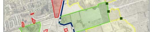
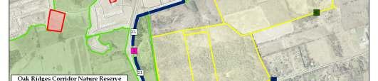
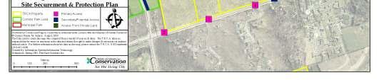
119 Map F.1: Oak Ridges Corridor Park East Site Securement Plan, Access Points 114
Resource Management Tract Management Plan. May, 2015 PHOTO NEEDED. Cover photo credit: Barry Westhead
 PHOTO NEEDED Resource Management Tract Management Plan May, 2015 A Cover photo credit: Barry Westhead 1.0 INTRODUCTION TABLE OF CONTENTS AUTHORITY RESOLUTION At Authority Meeting #6/14, held on July 25,
Geoscape Toronto The Oak Ridges Moraine Activity 2 - Page 1 of 10 Information Bulletin
 About 13,000 years ago as the Laurentide Ice Sheet melted, glacial meltwater accumulated between the ice sheet and the Niagara Escarpment. This formed a lake basin into which gravel and sand were deposited.
Conservation Area Management Statement
 Conservation Area Management Statement Miller Creek Wildlife Area Resolution #: Approval: Issue Date: Date of Last Revision: Table of Contents 1. Purpose....... 1 2. Property Description...... 1 2.1. Legal
SUSTAINING OUR ENVIRONMENT, PLANNING FOR OUR FUTURE
 SUSTAINING OUR ENVIRONMENT, PLANNING FOR OUR FUTURE Key Recommendations to Inform the 2015 Provincial Review of the Oak Ridges Moraine Conservation Plan APRIL 2015 KEY RECOMMENDATIONS TO INFORM THE 2015
Establishing a National Urban Park in the Rouge Valley
 STAFF REPORT ACTION REQUIRED Establishing a National Urban Park in the Rouge Valley Date: March 29, 2012 To: From: Wards: Reference Number: Executive Committee Deputy City Manager, Cluster B All p:\2012\cluster
Rouge National Park. Opportunities and Challenges
 Rouge National Park Opportunities and Challenges January 2013 Rouge Park Finch Meander Rouge Beach at Lake Ontario Toronto GLWQA Area of Concern Rouge National Park Nationally Significant First Nation
Green Legacy. Securing our. Greenlands Strategy
 Greenlands Strategy Securing our Green Legacy Together we can create an interconnected network of Greenlands for the health and well-being of the environment and future generations Caring for the Credit
Bayview Escarpment. Interim Management Statement
 Bayview Escarpment Interim Management Statement Bayview Escarpment Provincial Nature Reserve Interim Management Statement January 15, 1995 REGIONAL DIRECTOR'S APPROVAL STATEMENT This Interim Management
Proposed Official Plan Amendment 41 to the Region of York Official Plan
 COMMITTEE OF THE WHOLE NOVEMBER 18, 2002 REGION OF YORK OFFICIAL PLAN AMENDMENT 41 THE OAK RIDGES MORAINE CONSERVATION PLAN Recommendation The Commissioner of Planning recommends: 1. That the City of Vaughan
Land, Water and Community: Preparing for a Successful 2015 Review
 Land, Water and Community: Preparing for a Successful 2015 Review Outline ORM Partnership for 2015 Preparing for 2015: Three Plans versus Four Plans Our Areas of Focus Governance & the 2015 Process Our
Planning & Building Department
 Page 1 of Report Planning & Building Department To: Subject: Community Development Committee Protecting Escarpment Rural Land (PERL) Proposed Niagara Escarpment Plan Amendment Niagara Escarpment Commission
Pembina Valley Provincial Park. Draft Management Plan
 Pembina Valley Provincial Park Draft Management Plan 2 Pembina Valley Provincial Park Table of Contents 1. Introduction... 3 2. Park History... 3 3. Park Attributes... 3 3.1 Natural... 3 3.2 Recreational...
Parkland County Municipal Development Plan Amendment Acheson Industrial Area Structure Plan
 Parkland County Municipal Development Plan Amendment Acheson Industrial Area Structure Plan New Plan Acheson Industrial Area Structure Plan Amendment Parkland County Municipal Development Plan Board Reference
Amendment 41 to the Official Plan for the Regional Municipality of York
 Attachment 3 Council Report Attachment Amendment 41 to the Official Plan for the Regional Municipality of York As approved by the Minister of Municipal Affairs and Housing October 21, 2004 Deferred policies
Rouge River Watershed. Section 4.7 Nature-based Recreation
 Rouge River Watershed Scenario Modelling ling and Analysis Report Section 4.7 Nature-based Recreation TABLE OF CONTENTS 4.7 Nature-based Recreation... 4.7-1 4.7.1 Key Indicators... 4.7-1 4.7.2 Scenario
Map 1.1 Wenatchee Watershed Land Ownership
 Map 1.1 Wenatchee Watershed Land Ownership Map 1.1 Wenatchee Watershed Land Ownership The Wenatchee watershed lies in the heart of Washington state in Chelan County. Just larger than the state of Rhode
Whitemouth Falls Provincial Park. Draft Management Plan
 Whitemouth Falls Provincial Park Draft Management Plan Whitemouth Falls Provincial Park Draft Management Plan Table of Contents 1. Introduction... 3 2. Park History... 3 3. Park Attributes... 4 3.1 Natural...
Committee. Presentation Outline
 CW-33-15 11/9/2015 Community and Corporate Services Committee November 10, 2015 1 Presentation Outline Background Vision and Objectives Study Process and Timeline Public and Stakeholder Engagement Organization
Preferred Recreation Recommendations Stemilt-Squilchuck Recreation Plan March 2018
 Preferred Recreation Recommendations Stemilt-Squilchuck Recreation Plan March 2018 Below are the recommended recreation ideas and strategies that package together the various recreation concepts compiled
OPG, Nuclear 2
 B iodiversity Assessment Building a Biodiversity Management Plan November 24, 2011 OPG, Nuclear 2 Biodiversity Assessment What habitat, or your site? potential habitat, is available on What species of
3.0 EXISTING PARK & RECREATION SPACE
 3.0 EXISTING PARK & RECREATION SPACE TOWN PARK & RECREATION SPACE An inventory of current parks and recreation area in the Town of Cedarburg is shown in Table 3. These areas total roughly 381.89 acres.
Marchand Provincial Park. Management Plan
 Marchand Provincial Park Management Plan 2 Marchand Provincial Park Table of Contents 1. Introduction... 3 2. Park History... 3 3. Park Attributes... 4 3.1 Natural... 4 3.2 Recreational... 4 3.3 Additional
Watchorn Provincial Park. Management Plan
 Watchorn Provincial Park Management Plan 2 Watchorn Provincial Park Table of Contents 1. Introduction... 3 2. Park History... 3 3. Park Attributes... 3 3.1 Natural... 4 3.2 Recreational... 4 3.3 Additional
EXECUTIVE SUMMARY PROGRAM DEVELOPMENT REPORT PURPOSE EXISTING SETTING EXPANDING PARKLAND
 EXECUTIVE SUMMARY PROGRAM DEVELOPMENT REPORT PURPOSE As the culmination of the first phase of the master planning process, this Program Development Report creates the framework to develop the Calero County
Strategic Objectives, Initiatives and Actions
 Strategic Objectives, Initiatives and Actions The following Strategic Objectives and the associated Initiatives and Actions for each have been developed to meet the challenges associated with trail development
Nakina Moraine Provincial Park. Interim Management Statement. Ontario. Ministry of Natural Resources
 Nakina Moraine Provincial Park Interim Management Statement Ontario Ministry of Natural Resources 1999, Queen's Printer for Ontario Printed in Ontario, Canada Additional copies of this publication can
PROUDLY BRINGING YOU CANADA AT ITS BEST. Management Planning Program NEWSLETTER #1 OCTOBER, 2000
 PROUDLY BRINGING YOU CANADA AT ITS BEST VUNTUT NATIONAL PARK Management Planning Program NEWSLETTER #1 OCTOBER, 2000 INTRODUCTION This newsletter launches the development of the first management plan for
 March 25, 1994 To: Re: MEMO TO FILE MINOR AMENDMENT - PINERY PROVINCIAL PARK MANAGEMENT PLAN The following paragraph from page 5 of the Pinery Provincial Park Management Plan (ISBN 0-7729-0290-9) lnsects
Steps in the Management Planning Process
 Steps in the Management Planning Process Developing a management plan for Kalamalka Lake Park will follow a multi-stage process. The planning process for this park is currently in the Draft Management
AMENDMENT NO. 03 TO THE OFFICIAL PLAN FOR THE TOWNSHIP OF ADJALA-TOSORONTIO OAK RIDGES MORAINE CONSERVATION PLAN
 AMENDMENT NO. 03 TO THE OFFICIAL PLAN FOR THE TOWNSHIP OF ADJALA-TOSORONTIO OAK RIDGES MORAINE CONSERVATION PLAN Adopted by Council July 19 th, 2004 Approved with modifications by the Province of Ontario
CITY OF VAUGHAN EXTRACT FROM COUNCIL MEETING MINUTES OF OCTOBER 30, 2012
 CITY OF VAUGHAN EXTRACT FROM COUNCIL MEETING MINUTES OF OCTOBER 30, 2012 Item 36, Report No. 39, of the Committee of the Whole, which was adopted without amendment by the Council of the City of Vaughan
Submission to NSW Koala Strategy Consultation Process. March 2017
 Submission to NSW Koala Strategy Consultation Process March 2017 Table of contents Opening 3 Response 3 Whole-of-government NSW koala strategy 3 State Environment Planning Policy (SEPP) 44 3 The draft
DIXIE HIGHWAY Region of Peel NAI Area # 1304, 1320, 2449, 2625, 3961
 DIXIE HIGHWAY 407 1 Region of Peel NAI Area # 1304, 1320, 2449, 2625, 3961 Toronto and Region Conservation Authority City of Brampton Size: 36 hectares Watershed: Etobicoke Creek Con 4 E, Lots 13, 14 Ownership:
October 31, OAK RIDGES MORAINE FOUNDATION 120 BAYVIEW PARKWAY, NEWMARKET, ON L3Y 3W
 October 31, 2016 Land Use Planning Review Ministry of Municipal Affairs and Housing Ontario Growth Secretariat 777 Bay Street, Suite 425 (4th Floor) Toronto, ON M5G 2E5 RE: Oak Ridges Moraine Foundation
EAST DON TRAIL ENVIRONMENTAL ASSESSMENT. Community Liaison Committee Meeting #3 July 15, :30 to 8:30 pm Flemingdon Park Library
 EAST DON TRAIL ENVIRONMENTAL ASSESSMENT Community Liaison Committee Meeting #3 July 15, 2013 6:30 to 8:30 pm Flemingdon Park Library Agenda 1. Welcome 2. Housekeeping and Updates a) Housekeeping b) CLC
Michipicoten Island Regional Plan
 Michipicoten Island Regional Plan This is one of twenty Regional Plans that support implementation of the Lake Superior Biodiversity Conservation Strategy (Strategy). The Strategy, prepared and overseen
Lynde Creek Watershed. Lynde Creek Watershed CLOCA LYNDE CREEK WATERSHED EXISTING CONDITIONS REPORT CHAPTER 1 STUDY AREA
 Lynde Creek Watershed CLOCA Lynde Creek Watershed CLOCA LYNDE CREEK WATERSHED EXISTING CONDITIONS REPORT CHAPTER 1 STUDY AREA June 2008 TABLE OF CONTENTS 1.0 STUDY AREA... 3 1.1 Lynde Main Subwatershed...6
CITY CLERK. Oak Ridges Moraine Update. The Planning and Transportation Committee recommends that:
 CITY CLERK Clause embodied in Report No. 8 of the, as adopted by the Council of the City of Toronto at its meeting held on July 24, 25 and 26, 2001. 5 Oak Ridges Moraine Update (City Council on July 24,
Ministry of Parks, Culture and Sport. Plan for saskatchewan.ca
 Ministry of Parks, Culture and Sport Plan for 2018-19 saskatchewan.ca Table of Contents Statement from the Minister... 1 Response to Government Direction... 2 Operational Plan... 3 Highlights... 7 Financial
SOUTH INTERCHANGE AREA
 Santaquin City General Plan 1 Location and Characteristics The South Interchange Area of Santaquin is located west of Interstate 15 and south of 500 South (Figure 1). It includes properties already annexed
Planning and Building Department
 Page 1 of Report PB-27/11 CITY OF Burlington Planning and Building Department TO: Chair and Members of the Community Development Committee SUBJECT: Niagara Escarpment Plan Amendment 179 (NEPA 179) Addition
The Sunshine Coast is part of the global community and generates wealth through export, high-value industries and new investment.
 3.2 Strategic intent 3.2.1 Shaping growth an overview In 2031, the Sunshine Coast is renowned for its vibrant economy, ecological values, unique character and strong sense of community. It is Australia
OAK RIDGES MORAINE FOUNDATION
 June 2009 OAK RIDGES MORAINE FOUNDATION The Oak Ridges Moraine Foundation was created in 2002 to help preserve, protect and restore the environmental integrity of the Oak Ridges Moraine, a prominent geological
ETOBICOKE CREEK NORTH TRAIL PROJECT. May 18, 2017 at Michael Power High School 105 Eringate Drive, Etobicoke ON M9C 3Z7
 ETOBICOKE CREEK NORTH TRAIL PROJECT May 18, 2017 at Michael Power High School 105 Eringate Drive, Etobicoke ON M9C 3Z7 1 Purpose of Open House The purpose of today s open house is to present the design
Approval Statement. Brian Pfrimmer, Central Zone Manager Ontario Parks
 Approval Statement I am pleased to approve this Interim Management Statement for Dividing Lake Provincial Nature Reserve. This Nature Reserve contains biological features of provincial significance and
Proposal to Redevelop Lower Kananaskis River-Barrier Lake. Bow Valley Provincial Park
 Frequently Asked Questions Proposal to Redevelop Lower Kananaskis River-Barrier Lake Bow Valley Provincial Park Frequently Asked Questions What has been decided? What are the details of the plan? What
Land Management Summary
 photo credit: ANGAIR Anglesea Heath Land Management Summary The Anglesea Heath (6,501 ha) was incorporated into the Great Otway National Park in January 2018. This provides an opportunity to consider the
Criddle/Vane Homestead Provincial Park. Management Plan
 Criddle/Vane Homestead Provincial Park Management Plan 2 Criddle/Vane Homestead Provincial Park Table of Contents 1. Introduction... 3 2. Park History.... 3 3. Park Attributes.... 4 3.1 Natural.... 4 3.2
2.1 TITLE: VMC PARKS MASTER PLAN AND IMPLEMENTATION STRATEGY PROJECT UPDATE
 2.1 Item: VMC Sub-committee Report DATE: Tuesday, June 12, 2018 WARD: 4 TITLE: VMC PARKS MASTER PLAN AND IMPLEMENTATION STRATEGY PROJECT UPDATE FROM: Jason Schmidt-Shoukri, Deputy City Manager, Planning
The Oak Ridges Moraine: Proposals for the Protection and Management of a Unique Landsape
 Proposals for the Protection and Management of a Unique Landscape The Oak Ridges Moraine: Proposals for the Protection and Management of a Unique Landsape This report has been prepared jointly by the Regional
JOSLIN FIELD, MAGIC VALLEY REGIONAL AIRPORT DECEMBER 2012
 1. Introduction The Federal Aviation Administration (FAA) recommends that airport master plans be updated every 5 years or as necessary to keep them current. The Master Plan for Joslin Field, Magic Valley
3.0 LEARNING FROM CHATHAM-KENT S CITIZENS
 3.0 LEARNING FROM CHATHAM-KENT S CITIZENS An important aspect in developing the Chatham-Kent Trails Master Plan was to obtain input from stakeholders and the general public. Throughout the course of the
Proposal to Redevelop Lower Kananaskis River-Barrier Lake. Bow Valley Provincial Park. Frequently Asked Questions
 Proposal to Redevelop Lower Kananaskis River-Barrier Lake Bow Valley Provincial Park Frequently Asked Questions What is being proposed? What are the details of the proposal? Where is the project area located?
What is Pimachiowin Aki? What is The Land that Gives Life?
 What is Pimachiowin Aki? What is The Land that Gives Life? Pimachiowin Aki is Canada s newest and first mixed (cultural and natural) World Heritage Site. In Anishaabemowin, the Ojibwe language, Pimachiowin
CITY CLERK. Oak Ridges Moraine - Response to Province of Ontario's Draft Strategy
 CITY CLERK Clause embodied in Report No. 12 of the, as adopted by the Council of the City of Toronto at its meeting held on November 6, 7 and 8, 2001. 7 Oak Ridges Moraine - Response to Province of Ontario's
UNITED STATES DEPARTMENT OF THE INTERIOR BUREAU OF LAND MANAGEMENT MANUAL TRANSMITTAL SHEET
 Form 1221-2 (June 1969) UNITED STATES DEPARTMENT OF THE INTERIOR BUREAU OF LAND MANAGEMENT MANUAL TRANSMITTAL SHEET Release 8-83 Date Subject 8353 Trail Management Areas Secretarially Designated (Public)
A Master Plan is one of the most important documents that can be prepared by an Airport.
 The Master Plan A Master Plan is one of the most important documents that can be prepared by an Airport. A Master Plan is a visionary and a strategic document detailing planning initiatives for the Airport
White Mountain National Forest Saco Ranger District
 United States Department of Agriculture Forest Service White Mountain National Forest Saco Ranger District 33 Kancamagus Highway Conway, NH 03818 Comm: (603) 447-5448 TTY: (603) 447-3121 File Code: 1950
A Proposed Framework for the Development of Joint Cooperation On Nature Conservation and Sustainable Tourism At World Heritage Natural sites.
 Introduction: A Proposed Framework for the Development of Joint Cooperation On Nature Conservation and Sustainable Tourism At World Heritage Natural sites Between The tourism industry and the UNESCO, World
MANAGEMENT DIRECTION STATEMENT June, 1999
 Thompson River District MANAGEMENT DIRECTION STATEMENT June, 1999 for Roche Lake Provincial Park Ministry of Environment Lands and Parks BC Parks Division Table of Contents I. Introduction A. Setting
Global Sustainable Tourism Destinations Criteria
 Global Sustainable Tourism Destinations Criteria Draft destination level Global Sustainable Tourism Criteria as proposed after Destinations and International Standards joint working group meeting and follow-up
Strengthening the Ontario Trails Strategy. Report on Consultations and the Environmental Bill of Rights Registry
 Strengthening the Ontario Trails Strategy Report on Consultations and the Environmental Bill of Rights Registry Purpose To report on the feedback and information received through the regional consultations,
% farmers/private landowners in watershed applying BMPs. Other (Number of participants completed the training)
") Easygrants ID: 23803 National Fish and Wildlife Foundation NFWF/Legacy Grant Project ID: 0302.10.023803 U. S. Coral Reef Task Force Partnership Initiative 2010 - Submit Final Programmatic Report (Activities
Easygrants ID: 23803 National Fish and Wildlife Foundation NFWF/Legacy Grant Project ID: 0302.10.023803 U. S. Coral Reef Task Force Partnership Initiative 2010 - Submit Final Programmatic Report (Activities
6 Agricultural. and Rural Areas. Chapter. In this chapter:
 Chapter 6 Agricultural and Rural Areas In this chapter: 6.1 The Greenbelt Plan 6.2 The Oak Ridges Moraine Conservation Plan 6.3 Agricultural and Holland Marsh Specialty Crop Areas 6.4 Rural Area 6.5 Mineral
Port Bruce. Interim Management Statement
 Port Bruce Interim Management Statement Port Bruce Interim Management Statement August 3, 1999 This Port Bruce Provincial Park Interim Management Statement provides direction for the custodial management
Longmont to Boulder Regional Trail Jay Road Connection DRAFT FINAL REPORT
 Longmont to Boulder Regional Trail Jay Road Connection DRAFT FINAL REPORT December 2018 Project Summary Boulder County, Colorado, in partnership with the City of Boulder, is evaluating options for multi-use
MANAGEMENT DIRECTION STATEMENT June, 1999
 Thompson River District MANAGEMENT DIRECTION STATEMENT June, 1999 for Clearwater River Corridor (Addition to Wells Gray Park) Ministry of Environment Lands and Parks BC Parks Division ii Table of Contents
PERFORMANCE INDICATORS
 PERFORMANCE INDICATORS for the greenbelt plan Part 1, 2015 Ontario.ca/mah PERFORMANCE INDICATORS for the greenbelt plan Part 1, 2015 TABLE OF CONTENTS Page Welcome to Greenbelt Plan Performance Indicators
ROAD AND TRAIL PROJECT APPROVAL
 ROAD AND TRAIL PROJECT APPROVAL www.marincountyparks.org Marin County Parks, 3501 Civic Center Dr, Suite 260, San Rafael, CA 94903 DATE: July 12, 2017 PRESERVE: Gary Giacomini Open Space Preserve PROJECT:
Draft Strategic Plans for Coillte s eight Business Area Units ( )
") Draft Strategic Plans for Coillte s eight Business Area Units (2011-2015) Response to Public Consultation from Mountaineering Ireland April 2013 1 Introduction Mountaineering Ireland welcomes this opportunity
Draft Strategic Plans for Coillte s eight Business Area Units (2011-2015) Response to Public Consultation from Mountaineering Ireland April 2013 1 Introduction Mountaineering Ireland welcomes this opportunity
Pinellas County Environmental Lands
 Pinellas County Environmental Lands In addition to traditional parks and recreation facilities, Pinellas County owns and manages a system of environmental lands that provides specialized resource-based
Birch Point Provincial Park. Management Plan
 Birch Point Provincial Park Management Plan 2 Birch Point Provincial Park Table of Contents 1. Introduction... 3 2. Park History... 3 3. Park Attributes... 4 3.1 Natural... 4 3.2 Recreational... 4 4. Park
APPENDIX. Alberta Land Stewardship Act AMENDMENTS TO THE SOUTH SASKATCHEWAN REGIONAL PLAN
 APPENDIX Alberta Land Stewardship Act AMENDMENTS TO THE SOUTH SASKATCHEWAN REGIONAL PLAN 1 All references to Alberta Environment and Sustainable Resource Development, Environment and Sustainable Resource
RE: Access Fund Comments on Yosemite National Park Wilderness Stewardship Plan, Preliminary Ideas and Concepts
 September 30, 2016 Superintendent Yosemite National Park Attn: Wilderness Stewardship Plan P.O. Box 577 Yosemite, CA 95389 RE: Access Fund Comments on Yosemite National Park Wilderness Stewardship Plan,
THAT the Board approve the final proposed concept plan for the Jericho Marginal Wharf site as shown in Figure C-4 of Appendix C.
 Date: January 17, 2012 TO: Board Members Vancouver Park Board FROM: General Manager Parks and Recreation SUBJECT: Jericho Marginal Wharf Phase 2 Concept Plan RECOMMENDATION THAT the Board approve the final
SUMMER VILLAGE OF SILVER SANDS. Municipal Development Plan
 SUMMER VILLAGE OF SILVER SANDS Municipal Development Plan Bylaw 253-2014 Adopted August 22, 2014 Summer Village of Silver Sands Municipal Development Plan Bylaw No. 253-2014 Page 2 1 INTRODUCTION 1.1 SETTING
CHAPTER 6 NOISE EXPOSURE
 CHAPTER 6 NOISE EXPOSURE FAA requires that the NEM submitted for review represent the aircraft noise exposure for the year of submittal (in this case 2008) and for a future year (2013 for OSUA). However,
Section II. Planning & Public Process Planning for the Baker/Carver Regional Trail began in 2010 as a City of Minnetrista initiative.
 Section II Planning & Public Process Planning for the began in 2010 as a City of initiative. city staff began discussions with the Park District on the possibility of a north/south regional trail connection
Numaykoos Lake Provincial Park. Management Plan
 Numaykoos Lake Provincial Park Management Plan 2 Numaykoos Lake Provincial Park Table of Contents 1. Introduction... 3 2. Background... 3 3. Park Purpose... 5 4. Park Management Guidelines... 6 Appendix...
As outlined in the Tatshenshini-Alsek Park Management Agreement, park management will:
 Management Strategy General Strategy The priority management focus for the park is to ensure that its internationally significant natural, cultural heritage and recreational values are protected and that
Blueways: Rivers, lakes, or streams with public access for recreation that includes fishing, nature observation, and opportunities for boating.
 Parks, Open Space and Trails PRINCE WILLIAM COUNTY 2008 COMPREHENSIVE PLAN TRAILS PLAN CONTENTS The components of the trails plan are: Intent Definitions Goals, Policies, and Action Strategies Trails Map
National Wilderness Steering Committee
 National Wilderness Steering Committee Guidance White Paper Number 1 Issue: Cultural Resources and Wilderness Date: November 30, 2002 Introduction to the Issue Two of the purposes of the National Wilderness
Finn Creek Park. Management Direction Statement Amendment
 Finn Creek Park Management Direction Statement Amendment November 2013 Management Direction Statement Amendment Approved by: Jeff Leahy Regional Director, Thompson Cariboo BC Parks November 12, 2013 Date
Sasagiu Rapids Provincial Park. Draft Management Plan
 Sasagiu Rapids Provincial Park Draft Management Plan 2 Sasagiu Rapids Provincial Park Table of Contents 1. Introduction... 3 2. Background and Park Attributes... 3 2.1 Park History.... 3 2.2 Natural Features...
Wallace Lake Provincial Park. Management Plan
 Wallace Lake Provincial Park Management Plan 2 Wallace Lake Provincial Park Table of Contents 1. Introduction... 3 2. Park History... 3 3. Park Attributes... 4 3.1 Natural... 4 3.2 Recreational... 4 4.
MASTER PLAN EXECUTIVE SUMMARY
 Biscuit Run State Park Scottsville Road (State Route 20) Charlottesville, VA 22902 Biscuit Run State Park MASTER PLAN EXECUTIVE SUMMARY Department of Conservation and Recreation Division of Planning and
Spadina Avenue Built Form Study Preliminary Report
 STAFF REPORT ACTION REQUIRED Spadina Avenue Built Form Study Preliminary Report Date: July 9, 2014 To: From: Wards: Reference Number: Toronto and East York Community Council Director, Community Planning,
Open Space Index. Town of Philipstown. Adopted January 8, Submitted by: Philipstown Conservation Advisory Committee
 Open Space Index Town of Philipstown Adopted January 8, 2009 Submitted by: Philipstown Conservation Advisory Committee Acting Chair Eric Lind Mark Galezo Andy Galler Lew Kingsley Mike Leonard MJ Martin
MUNICIPALITY OF ANCHORAGE
 MUNICIPALITY OF ANCHORAGE ANCHORAGE PARKS & RECREATION Memorandum PRC 08-56 DATE: 5 August 2008 TO: FROM: SUBJECT: Parks & Recreation Commission Holly Spoth-Torres, Park Planner PRC 08-56 Far North Bicentennial
BACKCOUNTRY TRAIL FLOOD REHABILITATION PROGRAM
 BACKCOUNTRY TRAIL FLOOD REHABILITATION PROGRAM Backcountry Trail Flood Rehabilitation A June 2013 Flood Recovery Program Summary In June 2013, parts of Southern Alberta were devastated from significant
National Strategy for a Sustainable Trail System
 National Strategy for a Sustainable Trail System Forest Service December 30, 2016 Message from the Chief The Forest Service manages the largest trail system in the country, with unparalleled opportunities
2.0 Physical Characteristics
 _ 2.0 Physical Characteristics 2.1 Existing Land Use for the Project The site is comprised of approximately 114 acres bounded by Highway 101 to the north, the existing town of Los Alamos to the east, State
Draft Executive Summary
 Draft Executive Summary The Juneau Tourism Plan development process was undertaken by Egret Communications and ARA Consulting in April 2001, under contract with the City and Borough of Juneau, Alaska.
Continental Divide National Scenic Trail Legislative History and Planning Guidance
 Continental Divide National Scenic Trail Legislative History and Planning Guidance Legislation, Policy, and Direction Regarding National Scenic Trails The National Trails System Act, P.L. 90-543, was passed
MAPLEWOOD VILLAGE CENTRE AND INNOVATION DISTRICT IMPLEMENTATION PLAN & DESIGN GUIDELINES. November 6, 2017 Regular Meeting of Council
 MAPLEWOOD VILLAGE CENTRE AND INNOVATION DISTRICT IMPLEMENTATION PLAN & DESIGN GUIDELINES November 6, 2017 Regular Meeting of Council Recommendation THAT Council: Approve the Maplewood Village Centre and
Tourism and Wetlands
 CONVENTION ON WETLANDS (Ramsar, Iran, 1971) 43 rd Meeting of the Standing Committee Gland, Switzerland, 31 October 4 November 2011 DOC. SC43-27 Tourism and Wetlands Action requested. The Standing Committee
Ouimet Canyon Provincial Nature Reserve. Management Plan
 Ouimet Canyon Provincial Nature Reserve Management Plan NOTE: This document has been scanned and formatted, and therefore is slightly different from the original version. -March 2002 Additional copies
Chapter 2: Summary of Existing Open Space System
 Chapter 2: Summary of Existing Open Space System In 1976, the Wake County Board of Commissioners established the Wake County Parks and Recreation Department in order to provide park facilities and programs
White Lake Peatlands. Interim Management Statement
 White Lake Peatlands Interim Management Statement 2007 APPROVAL STATEMENT I am pleased to approve this Interim Management Statement for White Lake Peatlands Provincial Park. This park was regulated under
DECISION MEMO. Rawhide Trail #7073 Maintenance and Reconstruction
 Page 1 of 6 Background DECISION MEMO USDA Forest Service Jefferson Ranger District Jefferson County, Montana Rawhide Trail #7073 is located in the Elkhorn Mountain Range approximately 10 miles east of