Amendment 41 to the Official Plan for the Regional Municipality of York
|
|
|
- Roxanne Greer
- 5 years ago
- Views:
Transcription
1 Attachment 3 Council Report Attachment Amendment 41 to the Official Plan for the Regional Municipality of York As approved by the Minister of Municipal Affairs and Housing October 21, 2004 Deferred policies shown bolded and italicized
2 THE REGIONAL MUNICIPALITY OF YORK BILL NO. 25 BY-LAW NO. OP A by-law to adopt Amendment No. 41 to the Official Plan for the Region of York The Council of The Regional Municipality of York under sections 9 and 10 of the Oak Ridges Moraine Conservation Act, 2001, S.O. 2001, c. 31 and section 17(22) of the Planning Act, R.S.O. 1990, c. P.13, as amended, HEREBY ENACTS as follows: 1. Official Plan Amendment No. 41 to the Official Plan for The Regional Municipality of York (OPA No. 41) consisting of the text attached hereto as Schedule A is hereby adopted. ENACTED AND PASSED this 27 th day of March, Denis Kelly Regional Clerk Bill Fisch Regional Chair 2
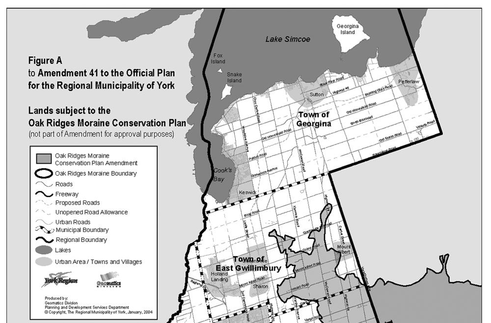
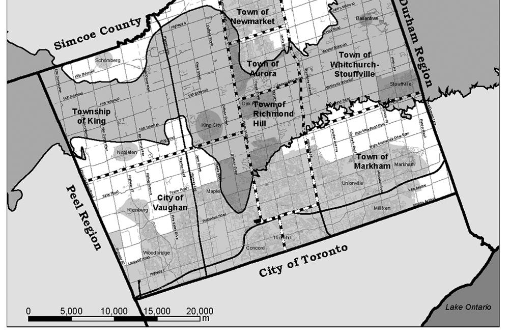
3 PROPOSED AMENDMENT 41 TO THE OFFICIAL PLAN FOR THE REGION OF YORK PART A - THE PREAMBLE 1. Purpose of the Amendment: The purpose of this amendment is to bring the Regional Official Plan into conformity with the Oak Ridges Moraine Conservation Plan (Ontario Regulation 140/02) as required by the Oak Ridges Moraine Conservation Act, Location: This Amendment affects all lands located in the Regional Municipality of York which are subject to the Oak Ridges Moraine Conservation Plan as illustrated on the context map Figure A to this Amendment. 3. Basis: On December 14, 2001 the Oak Ridges Moraine Conservation Act, 2001 received Royal Assent and was deemed to have come into force on November 16, The legislation provides for the establishment of the Oak Ridges Moraine Conservation Plan by Regulation. Ontario Regulation 140/02 the Oak Ridges Moraine Conservation Plan, came into effect on November 16, Through the Oak Ridges Moraine Conservation Act, 2001 and the accompanying Conservation Plan, the Province of Ontario has established a policy framework for protecting the Oak Ridges Moraine. Municipal planning decisions are required to conform with the Oak Ridges Moraine Conservation Plan, which prevails over municipal official plans. The boundary of the Oak Ridges Moraine has been identified by the Province and is based on a number of topographical, geomorphological and geological attributes. This amendment identifies the Oak Ridges Moraine Conservation Plan area on all Maps in the Regional Official Plan, amends Maps 2, Significant Natural Features, Map 3 Significant Forest Areas and Map 4 Regional Greenlands in so far as areas within the Oak Ridges Moraine are concerned and incorporates a new Map 11- Oak Ridges Moraine Conservation Plan Land Use Designations in the Regional Official Plan. This amendment also changes existing ROP policies by including references to the Oak Ridges Moraine Conservation Act and Plan. Where the ORMCP provides definitions of terminology, these terms have been shown underlined in this Plan, and readers are directed to the Oak Ridges Moraine Conservation Plan for the definitions. 3
4 4
5 PART B - THE AMENDMENT All of the Amendment entitled PART B - THE AMENDMENT, consisting of the attached Policy and Map changes constitutes Amendment 41 to the Official Plan for the Region of York. 1. Section 2.1 -The Regional Greenlands System, is amended by the following: a) Policy is amended by the addition of a new sentence as follows at the end of the clause: Mineral aggregate operations or wayside pits are permitted within those portions of the Regional Greenlands System designated as Natural Linkage Area and Countryside Areas on Map 11 - Oak Ridges Moraine Land Use Designation to this Plan and are subject to all applicable provisions of the Oak Ridges Moraine Conservation Plan (ORMCP). b) A new Policy is added as follows: Within the Oak Ridges Moraine Planning Area, the Regional Greenlands System shall be comprised of the ORMCP Natural Core Area and Natural Linkage Area designations and subject to the policies of the ORMCP for these designations These designations are reflected on Map 4 to this Plan. Within the Urban Areas and Towns and Villages, the Regional Greenlands System shown on Map 4 may be further refined through area municipal official plans and zoning by-laws without amendment to this plan. In these communities, the Policy provisions of this Plan or local official plans or secondary plans, whichever are the more restrictive, shall prevail. Key Natural Heritage and Hydrologically Sensitive Features within the ORMCP area and identified on Maps 2, 3 and 12 of this Plan shall be protected in accordance with the ORMCP. 2. Section 2.2 Land, is amended by the following: a) Policy , is amended by the addition of the words and key natural heritage features b) Policy , by the addition of a new clause e) as follows: e) conforms with the applicable provisions of the ORMCP for those wetlands within the ORMCP area. 5
6 c) By the addition of a new Policy as follows with renumbering of subsequent sections: Significant Forested Lands (being the same as Significant Woodlands under the ORMCP) on the Oak Ridges Moraine have been identified and are shown on Map 3 to this Plan. Development or site alteration within these features and within the minimum vegetation protection zone is prohibited, except where it meets the applicable provisions of the Oak Ridges Moraine Conservation Plan. d) By the addition of new Policies through as follows: Oak Ridges Moraine Landform Conservation Within the Oak Ridges Moraine, applications for development or site alteration proposed in a landform conservation area (category 1 and 2) shall be accompanied by the appropriate study as required by the ORMCP. Planning, design and construction practices for any development or site alteration permitted by the ORMCP are required to satisfy Section 30 of the Oak Ridges Moraine Conservation Plan Landform Conservation Areas (categories 1 and 2) are shown on Figure 1. Figure 1 is to be consulted whenever development or site alteration is proposed to determine if the Landform Conservation provisions of this Plan and the ORMCP apply To require area municipalities to incorporate the Oak Ridges Moraine landform conservation mapping and policies into their official plans and require that applications for development or site alteration in a landform conservation area (Category 1 and 2) identify planning, design and construction practices that will keep disturbance to landform character to a minimum, and subject to the requirements established under Section 30 of the ORMCP In accordance with Section 30(7) and (11) of the ORMCP, mineral aggregate operations are not subject to the requirements established under Sections 30(5), (6) and (10) In considering development and site alteration applications in the Urban Areas and Towns and Villages under this Plan, local municipalities shall consider the importance of adopting planning, design and construction practices that will keep disturbance to landform character to a minimum, so as to satisfy the requirements of Section 30 of the ORMCP if possible Applications for development and site alteration with respect to lands in an area of natural and scientific interest (earth science) on Figure 1 or the related minimum area of influence as identified in the Table of the ORMCP, shall be 6
7 accompanied by an earth science heritage evaluation that meets the requirements identified under Section 30(12) of the ORMCP. 3. Section 2.3, Water is amended by the addition of a new Policy as follows: Notwithstanding other policies of this section, in the Oak Ridges Moraine Conservation Plan area as shown on Map 11, reference shall be made to Section 2.5 of this Plan and all applicable provisions of the Oak Ridges Moraine Conservation Plan (ORMCP). Where there is a conflict between this Plan and the applicable provisions of the ORMCP, the more restrictive of the policies shall prevail. 4. Section 2.5 Oak Ridges Moraine, is deleted in its entirety to be replaced by the following: 2.5 Oak Ridges Moraine The Oak Ridges Moraine is one of Ontario s most significant landforms. Located north of and parallel to Lake Ontario, the Moraine in York Region divides the watersheds draining south into Lake Ontario from those draining north into Lake Simcoe. The Moraine shapes the present and future form and structure of the Greater Toronto Region and its ecological and hydrological features and functions are critical to the region s continuing health. Through the Oak Ridges Moraine Conservation Act, 2001 and the accompanying Oak Ridges Moraine Conservation Plan (ORMCP), the Province has established the direction for protecting, restoring and enhancing the Oak Ridges Moraine s ecological and hydrological features and functions. The ORMCP boundary and area is shown on all Maps to this Regional Plan. Land Use designations within the Oak Ridges Moraine Conservation Plan area are shown on Map 11. Municipal official plans and zoning bylaws must conform to the ORMCP, however, nothing in this Plan prevents an area municipality from being more restrictive in its official plan or its zoning by-law except with respect to agricultural uses, mineral aggregate operations and wayside pits in accordance with Section 33 of the ORMCP. Council of the Regional Municipality of York and its area municipalities are committed to the implementation of the Oak Ridges Moraine Conservation Plan. The major provisions of the ORMCP relevant at the Regional level have been incorporated into this section of the Regional Official Plan, however, these policies must be read in conjunction with the detailed provisions of the Oak Ridges Moraine Conservation Plan and the applicable area municipal official plan and zoning by-law. 7
8 Objectives: Through the establishment of this official plan, together with the Oak Ridges Moraine Conservation Plan, it is the goal of the Region of York to ensure, among others, that the following objectives are met in the Oak Ridges Moraine Area: a) protecting the ecological and hydrological integrity of the Oak Ridges Moraine; b) ensuring that only land and resource uses that maintain, improve or restore the ecological and hydrological functions of the Oak Ridges Moraine Area are permitted; c) ensuring that the Oak Ridges Moraine Area is maintained as a continuous natural landform and environment for the benefit of present and future generations; and d) providing for land and resource uses and development/site alteration that is compatible with the other objectives of the Oak Ridges Moraine Conservation Plan, including providing for continued development within existing urban areas and Hamlets It is the policy of Council: 1. To recognize the boundary and land use designations of the ORMCP area as shown on Map 11. Along the southern boundary of the Moraine, east of Bathurst Street, the ORMCP applies to lands within the Plan boundary and above the 245 metre ASL CGD contour line. In the event of a question regarding plan applicability in this area, the Region will require a topographic survey certified by an Ontario Land Surveyor (OLS), and based on field surveys tied to Ontario Geodetic Datum before planning decisions are made on specific applications. 2. That applications for development or site alteration within the ORMCP area will only be considered where they comply with the provisions of the ORMCP. Within the ORMCP the following land use designations and permitted uses apply: a) Natural Core Areas are areas with a high concentration of key natural heritage features, hydrologically sensitive features, and/or landform conservation areas and are critical to maintaining and improving the integrity of the Moraine as a whole. New permitted uses are very limited and may include conservation and resource management, low intensity recreation, or agriculture uses as detailed in the ORMCP. b) Natural Linkage Areas are areas forming part of a central corridor system that support or have the potential to support movement of plants and animals between the Natural Core Areas, Natural Linkage Areas, river valleys and stream corridors. 8
9 Limited new uses may include those permitted in the Natural Core Area designation as well as mineral aggregate operations and wayside pits as detailed in the ORMCP. c) Countryside Areas are areas of existing rural land uses which may include agriculture, major recreation, Hamlets, mineral aggregate operations, park and open space. Small scale industrial, commercial, and institutional uses shall be directed to Hamlets, Towns and Villages and Urban Areas. Hamlets, designated within area municipal official plans and located within the Countryside Area are generally depicted on Map 11, and are intended to provide opportunities for minor residential infill and smallscale industrial, commercial and institutional uses in accordance with local official plans. Notwithstanding the above permitted uses, major recreational uses are not permitted to locate in prime agricultural areas as shown as Agricultural Policy Area on Map 6 of the Regional Official Plan. Area municipal official plans may further refine the location of prime agricultural lands. d) Urban Areas and Towns and Villages on the Moraine are intended to focus and contain urban growth. These areas permit a full range of residential, commercial, industrial, and institutional uses. The ORMCP designation of Settlement Area on the Moraine in York includes Urban Areas (Aurora, Newmarket, Vaughan and Richmond Hill) and Towns and Villages (King City, Nobleton, Mt. Albert, and Stouffville). In these areas, existing Regional policies and municipal official plans shall guide development subject to the applicable provisions of the ORMCP. In the Town of Richmond Hill, the ORMCP provides for the designation of an urban area on the west side of Leslie Street, between Stouffville Road and Bethesda Road. Development of this area shall not be permitted until the provisions of the ORMCP have been satisfied, the community building and servicing policies of section 5.2 of the Regional Official Plan have been satisfied. 3. That transportation, infrastructure and utilities are prohibited in all Oak Ridges Moraine Land Use designations, including all key natural heritage features and hydrologically sensitive features unless the provisions of Section 41 of the ORMCP has been met, including the need for the project has been demonstrated. Need for a project will be typically assessed and included as part of an Environmental Assessment Act process. If an Environmental Assessment Act process does not apply, the requirements of Section 41 will be met through Planning Act, Condominium Act, and Local Improvement Act processes, or 9
10 other applicable approval processes. Also, the opening of a road within an unopened road allowances, are prohibited unless all other requirements of the ORMCP are met. 4. For transportation, infrastructure and utility uses proposed as part of a secondary planning process in Urban Areas or Towns and Villages, or Countryside Areas, Master Environmental Servicing Plans or Functional Servicing Plans may be used to satisfy the requirements of Section 41 of the ORMCP. In such cases, the approval authority shall determine timing of the studies completion. Key Natural Heritage Features, Hydrologically Sensitive Features 5. That Key Natural Heritage Features and Hydrologically Sensitive Features within the ORMCP refer to: significant portions of the habitat of endangered, rare and threatened species, fish habitat, Areas of Natural and Scientific Interest (life science and earth science), significant valleylands, significant woodlands, significant wildlife habitat sand barrens, savannas and tallgrass prairies, permanent and intermittent streams, wetlands, kettle lakes and seepage areas and springs. 6. That Environmentally Significant Areas on the Oak Ridges Moraine, identified by the Conservation Authorities, are also considered as key natural heritage features, subject to the same requirements for protection and study as those identified in the ORMCP for Areas of Natural and Scientific Interest (life science). For the purposes of this Plan, Environmentally Significant Areas and ANSI s (life science) are shown separately on Map That key natural heritage features, hydrologically sensitive features, earth science areas of natural and scientific interest and environmentally significant areas are shown on Map 2, 3, 12 and Figure 1 of the Regional Official Plan, save and except for the following features: significant valleylands, sandbarrens, savannas and tallgrass prairies, significant wildlife habitat, seepage areas and springs. These features shall be identified in accordance with criteria provided by the Province on a site-by-site basis or through the appropriate study such as a watershed plan and/or natural heritage or hydrological evaluations, prior to undertaking any development or site alteration on the Oak Ridges Moraine. 10
11 Significant portions of habitat for endangered, rare and threatened species have not been shown specifically on either the Maps or Figures. These habitat areas are instead included as part of either a Life Science ANSI or an Environmentally Significant Area. Fish habitat on the Oak Ridges Moraine are to include but is not limited to all hydrologically sensitive features with surface water characteristics. 8. That development and site alteration shall be prohibited within key natural heritage features and hydrologically sensitive features and Environmentally Significant Areas on the Oak Ridges Moraine and their related minimum vegetation protection zone of 30 metres or as required by in the Table in the ORMCP, except as provided for in sections 22(2), 26(2) and 35(4) of the ORMCP 9. Where new development or site alteration is proposed within the minimum area of influence surrounding a key natural heritage feature and/or a hydrologically sensitive feature, or an Environmentally Significant Areas; a natural heritage evaluation and/or a hydrological evaluation, as detailed in ORMCP is required. An evaluation may result in the minimum vegetative protection zone greater than that shown in the Table to the ORMCP. 10. Site specific studies conducted in accordance with the requirements in the ORMCP or updated information from the Province of Ontario resulting in minor changes to the extent or presence of key natural heritage or hydrologically sensitive features, or the Conservation Authority in regard to Environmentally Significant Areas will not require an amendment to this Plan. However, where a minor change may negatively affect a wetland, life science ANSI, fish habitat or significant portions of endangered, rare or threatened species, confirmation will be required from the Ministry of Natural Resources prior to any development or site alteration occurring in these areas. In regard to minor changes to Environmentally Sensitive Areas, confirmation will be required by the Conservation Authority. 11. No new agricultural uses and/or agriculture-related uses and accessory uses shall be permitted within a key natural heritage feature and/or a hydrologically sensitive feature and their associated minimum vegetation protection zone if the lands were not being used for that use on November 15, In Urban Areas and Towns and Villages, designated on April 22, 2002 and shown on Map 11, where secondary plans, official plans or zoning bylaws or Master Environmental Servicing or Functional Servicing Plans are approved based on environmental studies that have identified minimum vegetative protective zones that are different from those identified in the ORMCP, then the standards established within those plans shall prevail. 11
12 13. Every application for development or site alteration shall identify planning, design and construction practices that ensure that no buildings or other site alterations impede the movement of plants and animals among key natural heritage features, hydrologically sensitive features and adjacent lands within Natural Core Areas and Natural Linkage Areas. GROUNDWATER AND SURFACE WATER PROTECTION Protection of our water resources is imperative to ensure the health of our residents and the maintenance of our ecosystem. The ORMCP requires comprehensive watershed planning, identification of high aquifer vulnerability areas, the establishment of wellhead protection areas and the assessment of potential impact of land uses to the aquifers, groundwater and surface water features and functions. Watershed plans are comprehensive management strategies that seek to understand the interconnections between terrestrial and aquatic components of the natural system. In addition to achieving a better understanding of overall ecosystem function, watershed plans support change through an ecosystem-based approach to land-use planning. These plans assist in the management of land/water interactions and land use planning decisions and direct how water resources are to be protected and enhanced in relation to changing land uses. Watershed Plans have already been commenced for watersheds in the Region whose headwaters are within the Oak Ridges Moraine. Where necessary, updates and addenda to these plans to ensure their compliance with the requirements with the Oak Ridges Moraine Conservation Act will be undertaken within the timeframes established in the ORMCP. 14. To complete and implement watershed plans, in consultation with area municipalities and the Conservation Authorities, including water budgets and water conservation plans to meet the requirements of the ORMCP. 15. To require area municipalities and the Region to incorporate by official plan amendment, the applicable objectives and requirements of a completed watershed plan and the results of related environmental studies and monitoring plans into their planning documents as appropriate. 16. To prohibit all development and site alteration in a subwatershed, on the Oak Ridges Moraine, except in an Urban Area or Towns and Villages, if it would cause the total percentage of the subwatershed area on the Oak Ridges Moraine having impervious surfaces to exceed 10 percent, or any lower percentage specified in an approved watershed or subwatershed study. 12
13 17. To prohibit the approval of major development on the Oak Ridges Moraine after April 23, 2007, unless the relevant requirements of Section 24 of the ORMCP have been satisfied. Wellhead Protection areas are zones around wells where land uses must be carefully planned to protect the quality of the water supply. Wellhead Protection areas are based on the time estimated for a contaminant to travel from its point of origin to the well. In these areas, it may be necessary to restrict or even prohibit certain land uses from locating due to their potential to impact groundwater. These restrictions will be identified in Regional and area municipal official plans and the uses restricted through zoning by-laws. 18. To undertake studies and modeling to determine the location and extent of wellhead protection areas on the Oak Ridges Moraine for all municipal wells. 19. To identify and incorporate wellhead protection area mapping and policies for lands on the Oak Ridges Moraine into this Plan and area municipal official plans and zoning by-laws, in consultation with area municipalities. 20. To incorporate minimum times of travel of 0 to 150 days; 0 to 2 years; 2 to 10 years and 10 to 25 years in the identification of wellhead protection areas in area municipal plans and zoning by-laws. 21. To prohibit or restrict the establishment of land uses which involve the storage or manufacture of petroleum based fuels or solvents, pesticides, herbicides, fungicides or chlorinated solvents, inorganic chemicals, road salt or severely toxic chemicals identified by either Provincial or Federal Statute or Regulation in wellhead protection areas in accordance with Section 28 of the ORMCP 22. To investigate the need and potential for undertaking risk management planning including spills response, contaminant recovery and aquifer rehabilitation plans where land uses involving the storage of potential contaminants in identified wellhead protection areas. 23. To prohibit the storage of animal manure, animal agriculture and the storage of agricultural equipment for other than personal or family use within the 0 to 2 year time of travel zone in wellhead protection areas. 24. To require area municipal official plans and by-laws to contain specific policies which implement the wellhead protection policies of the ORMCP and to assist area municipalities in the review and approval of site management and contingency plans as required by the ORMCP. 13
14 25. To work with the agricultural community in establishing appropriate nutrient management planning for farming operations within wellhead protection areas to ensure that animal manure or agricultural operations or the storage of agricultural equipment does not impact the aquifer Aquifer Vulnerability refers to the shallow groundwater aquifer s susceptibility to contamination from both human and natural sources. Map 13 identifies the location of areas of high and low aquifer vulnerability. This Map shall be consulted in determining whether the Aquifer Vulnerability provisions of the ORMCP apply to specific development and site alteration applications 26. In areas of high aquifer vulnerability, to prohibit or restrict the generation and storage of hazardous waste or liquid industrial waste; waste disposal sites and facilities; organic soil conditioning sites and snow storage and disposal facilities; underground and above ground storage tanks that are not equipped with an approved secondary containment device; and storage of a contaminant listed in Schedule 3 (Severely Toxic Contaminants) to Ontario Regulation To require that area municipal official plans contain mapping and applicable policies that prohibit or restrict uses in areas of aquifer vulnerability in accordance with the requirements of the ORMCP. Existing Uses 28. Uses, buildings and structures, legally existing on November 15, 2001 are permitted in every land use designation. Area municipalities, as part of their conformity exercise shall determine the ultimate zoning of such uses. 29. Existing institutional uses and their expansions are permitted subject to Section 6 of the ORMCP and local official plans and zoning by-laws. Where expansion of such uses is applied for, the applicant shall demonstrate that the expansion will not adversely affect the ecological integrity of the ORMCP area and may require additional studies as identified in Part III and IV of the ORMCP. Transitional Provisions and Further Approvals Within the Oak Ridges Moraine there are applications under the Planning Act and Condominium Act, which, due to their date of commencement and decision are subject to the Transition and Further Approval provisions of the Oak Ridges Moraine Conservation Act, 2001 (Section 15 and 17). 30. All applications, as defined under the Oak Ridges Moraine Conservation Act, 2001, which commenced on or after November 17, 2001 are required to conform with the ORMCP. 14
15 31. Applications in Natural Core, Natural Linkage or Countryside Areas/Hamlets, that were commenced but were not decided prior to November 17, 2001, as defined in the Oak Ridges Moraine Conservation Act, 2001 are required to conform to the prescribed provisions under Section 48 of the ORMCP. 32. Applications in Natural Core and Natural Linkage that were commenced and decided before November 17, 2001 as defined in the Oak Ridges Moraine Conservation Act, 2001 are not subject to the provisions of the ORMCP provided that the use, building or structure for which the application was intended, is legally existing as of the date of adoption of this Plan. 33. Notwithstanding policies 30, 31 and 32 where a planning application is submitted after November 17, 2001 as a direct result from a condition attached to a provisional consent, a draft plan of subdivision or a draft plan of condominium, such an application shall be completed under the same system in effect as the original approval in accordance with Section 17(1) of the Oak Ridges Moraine Conservation Act, 2001 (as amendment by Bill 27, The Greenbelt Protection Act, 2004). In addition, any development permission established by such a further approval may be recognized in the local municipal official plan and zoning bylaw, as appropriate. Major Development 34. Applications for major development as defined under the ORMCP are required to meet additional provisions, particularly as it relates to Section 43 (water and sewer services) and Sections 45 and 46 (stormwater management). These requirements shall be considered in addition to all other provisions of the ORMCP. Implementation 35. Nothing in this Plan prevents area municipal official plans and zoning by-laws from being more restrictive than this Plan or the Oak Ridges Moraine Conservation Plan, except in-so-far as agricultural uses, mineral aggregate operations and wayside pits are concerned. In the event of a conflict the more restrictive policies shall apply. 36. To require area municipalities to develop appropriate policies in their official plans and zoning by-laws to implement and refine the requirements of the ORMCP. Policies include, but are not limited to those addressing the continuation of existing uses, permitting residential dwellings on existing lots of record, addressing accessory structures, the applicability of the Table in Part III of the ORMCP to existing uses, second dwellings, lots of record, approved uses, consents, and permitted uses. 15
16 37. That area municipalities shall be supported in adopting innovative approaches to assist in implementing the ORMCP, including but not limited to the use of development permit or zoning systems. 38. That the Region will work with area municipalities, adjacent Regions, the Province and stakeholders in assisting in understanding and implementing the ORMCP. 39. That area municipalities shall adopt site alteration and tree-cutting by-laws in conformity with the Municipal Act in accordance with the Oak Ridges Moraine Conservation Act, Certain planning and technical terms as underlined in this Plan have been specifically defined under the Oak Ridges Moraine Conservation Plan. These definitions shall be consulted as part of the Region s review of future planning applications. 5. Section 5.8 Mineral Aggregate Resource Areas, is amended by the addition of a new policy as follows: Within the Oak Ridges Moraine, existing and new mineral aggregate operations shall comply with the provisions of the ORMCP, particularly sections 35 and Section 5.10 Consents is amended by the addition of a new Policy All subsequent subsections are also renumbered: Within the Oak Ridges Moraine, consents will be permitted only where they conform to the Oak Ridges Moraine Conservation Plan and the area municipal Official Plans and Zoning By-laws. In the event of a conflict, the more restrictive of the Policies shall apply. 7. Chapter 6 Regional Infrastructure, Section 6.1 The Road Network is amended by the addition of a new policy as follows: Within the Oak Ridges Moraine Conservation Plan area, all improvements to the Regional Transportation and Roads Network, including the opening of a road within an unopened road allowance shall conform to the tests contained in Section 41 of the ORMCP. These tests will be met through the Environmental Assessment Act process for infrastructure. In planning for the Regional Transportation and Roads network, the Region will consider restrictions to haulage routes for transportation of chemicals and volatile materials in wellhead protection areas and in areas of high aquifer vulnerability. 16
17 8. Section 6.7 Water and Sewer Strategies is amended by the addition of new policies and as follows: Within the Oak Ridges Moraine Conservation Plan area, all improvements to sewer and water infrastructure systems shall conform to the tests contained in section 41 of the ORMCP. These tests will be met through the normal Environmental Assessment Act process for infrastructure The construction or expansion of partial services is prohibited in the Oak Ridges Moraine Conservation Plan area unless: 1) it has been deemed necessary to address a serious health or environmental concern identified by the local Medical Officer of Health or other designated authority; or 2) if the construction or expansion was approved under the Environmental Assessment Act before November 17, 2001and the period of time during which the construction or expansion may begin has not expired. 9. Chapter 7 - Implementation, is amended as follows: a) Section 7.7 Amendments to the Plan, is amended by the addition of a new Policy as follows: That no amendments to land use designations will be considered within the Oak Ridges Moraine Conservation Plan area of the Region of York until April 22, 2012, except as provided for in the ORMCP and the Oak Ridges Moraine Conservation Act, 2001, however, in no case will amendments be considered which would have the effect of removing form the Natural Core Area and the Natural Linkage Area designations. b) Section 7.4 Monitoring, Plan Review and Updating, is amended by the addition of the following new policy 7.4.6: That within the Oak Ridges Moraine Conservation Plan area the Region shall: a) In partnership with the Province and other stakeholders, undertake the development and administration of effective and accessible data management systems for natural heritage and groundwater information. b) Work with the Province (including conservation authorities and area municipalities) and other stakeholders to develop a series of programs to monitor the long-term health of the Moraine, including the completion of groundwater, natural heritage, land use and surface water 17
18 studies and to assist in public education respecting the Oak Ridges Moraine c) Section 7.6 Interpretation, is amended by the addition of a second clause to Policy as follows: Figure 1 shows factual and/or conceptual information available at the time of the preparation of the Plan, and are included in the Regional Plan for information purposes to show the categories of areas subject to specific policies of the Plan. Information shown on Figure 1 may be changed or updated from time to time through direction by the Province without requiring an amendment to this Plan. d) Section 7.6 Interpretation, Policy is amended by the addition of the following at the end of the Policy:, except in the case of the Boundary of the Oak Ridges Moraine Conservation Plan. In this case, the boundary may only be clarified through reference to the applicable Ontario Regulation. 10. Maps 2 through 10 of the Regional Plan are hereby amended by the addition of the Oak Ridges Moraine Conservation Plan boundary as defined by Ontario Regulation 01/02, with the area within the boundary on Maps 2, 3, 4 and 5 through 10, shown as a screened tone, and by the addition of the following to the legend of each Map: Oak Ridges Moraine Conservation Plan Area-Refer to Section 2.5 and all other applicable sections of this Plan as it relates to the Oak Ridges Moraine, including the Oak Ridges Moraine Conservation Plan itself. 11 That Map 2- Significant Natural Features is amended by deleting those Environmental Policy Area and wetlands designations within the Oak Ridges Moraine Conservation Plan Area to be replaced by the attached key natural heritage and hydrologically sensitive features and environmentally significant areas shown on Map 2 (dated August 2004) and 12 (dated June 2004) to this Amendment. 12. That Map 3-Significant Forested Resources is amended by deleting those Significant Forested Land designations within the Oak Ridges Moraine Conservation Plan area to be replaced by the attached Significant Forest Resources designation shown on Map 3 dated July 2004 to this Amendment. 13. That Map 4- The Regional Greenlands System is amended by deleting those Regional Greenlands designations and the Oak Ridges Moraine trail designation within the Oak Ridges Moraine Plan Area, to be replaced by the designations and legend shown on Map 4 dated March 2004 to this Amendment. 18
19 14. That Map 5- Regional Structure, be amended by the following: a. Identification of the Community of Ballantrae consistent with the designation established on Map 11 (dated May 2004); b. Identification of an Urban Area designation on the west side of Leslie Street north of Stouffville Road in the Town of Richmond Hill; and c. Identification of a Town or Village designation for the Community of Nobleton consistent with the designation established in the ORMCP. d. Redesignation of that portion of the lands known municipally as Bayview Avenue in the Town of Aurora from Countryside Area to Urban Area consistent with the designation established on Map 11 (dated May 2004) 15. That Map 6 Agriculture and Rural Policy Area be amended by deleting the Agriculture Policy Area and Rural Policy Area designations from the following: (i) Within the specific boundaries for the Community of Ballantrae consistent with the boundary established on Map 11; (ii) Within the Urban Area designation on the west side of Leslie Street north of Stouffville Road in the Town of Richmond Hill; and (iii) Identification of a Town or Village designation for the community of Nobelton consistent with the designation established in the ORMCP; and, (iv) That portion of the lands known municipally as Bayview Avenue in the Town of Aurora consistent with the designation established on Map 11 (dated May 2004) 16. That a new map dated May 2004, Map 11 Oak Ridges Moraine Land Use Designations, be added to the Region of York Official Plan with identification of the land use designations in the legend of the Map in accordance with the Oak Ridges Moraine Conservation Plan, save and except the term Settlement Area which shall be replaced by term Urban Area or Towns and Villages in accordance with the approved hierarchy of settlements shown on Map 5 Regional Structure of the Regional Official Plan 17. That a new Figure dated March 2004, Figure 1 - Oak Ridges Moraine Landform Conservation Areas, be added to the Region of York Official Plan. 18. That a new Map dated June 2004, Map Oak Ridges Moraine ESA s and ANSI s, be added to the Region of York. 19. That a new Map dated March 2004, Map 13 - Oak Ridges Moraine Aquifer Vulnerability Areas, be added to the Region of York Official Plan. 19
AMENDMENT NO. 03 TO THE OFFICIAL PLAN FOR THE TOWNSHIP OF ADJALA-TOSORONTIO OAK RIDGES MORAINE CONSERVATION PLAN
 AMENDMENT NO. 03 TO THE OFFICIAL PLAN FOR THE TOWNSHIP OF ADJALA-TOSORONTIO OAK RIDGES MORAINE CONSERVATION PLAN Adopted by Council July 19 th, 2004 Approved with modifications by the Province of Ontario
Proposed Official Plan Amendment 41 to the Region of York Official Plan
 COMMITTEE OF THE WHOLE NOVEMBER 18, 2002 REGION OF YORK OFFICIAL PLAN AMENDMENT 41 THE OAK RIDGES MORAINE CONSERVATION PLAN Recommendation The Commissioner of Planning recommends: 1. That the City of Vaughan
AMENDMENT #230 TO THE OFFICIAL PLAN OF THE TOWNSHIP OF KING PLANNING AREA
 AMENDMENT #230 TO THE OFFICIAL PLAN OF THE TOWNSHIP OF KING PLANNING AREA Oak Ridges Moraine Conservation Plan Amendment to Township of King Official Plan Amendment #23 (Hamlet Secondary Plan) October
OFFICIAL PLAN AMENDMENT 604 TO THE VAUGHAN PLANNING AREA
 OFFICIAL PLAN AMENDMENT 604 TO THE VAUGHAN PLANNING AREA AMENDING OFFICIAL PLAN AMENDMENTS 332, 350 AND 600 TO BRING THEM INTO CONFORMITY WITH THE OAK RIDGES MORAINE CONSERVATION PLAN, ONTARIO REGULATION
6 Agricultural. and Rural Areas. Chapter. In this chapter:
 Chapter 6 Agricultural and Rural Areas In this chapter: 6.1 The Greenbelt Plan 6.2 The Oak Ridges Moraine Conservation Plan 6.3 Agricultural and Holland Marsh Specialty Crop Areas 6.4 Rural Area 6.5 Mineral
(1) GENERAL POLICIES (2) EXISTING USES
 GENERAL POLICIES (2) EXISTING USES") (1) GENERAL POLICIES (d) (e) The policies of Section 20 shall apply to all lands located within the area shown on Schedule A - Land Use and Roads Plan as Oak Ridges Moraine. Schedule E-1 - Oak Ridges Moraine
(1) GENERAL POLICIES (d) (e) The policies of Section 20 shall apply to all lands located within the area shown on Schedule A - Land Use and Roads Plan as Oak Ridges Moraine. Schedule E-1 - Oak Ridges Moraine
Ontario Municipal Board Commission des affaires municipales de l Ontario
 Commission des affaires municipales de l Ontario ISSUE DATE: July 25, 2014 CASE NO: PL130788 PROCEEDING COMMENCED UNDER subsection 17(36) of the Planning Act, R.S.O. 1990, c. P.13, as amended Subject:
Oak Ridges Moraine Conservation Plan Amendment to Township of King Official Plan
 Oak Ridges Moraine Conservation Plan Amendment to Township of King Official Plan FINAL FORMAL AMENDMENT DOCUMENT OFFICIAL PLAN AMENDMENT #1970 October 22, 2003 PART I: THE PREAMBLE 1. Amendment Structure
SUSTAINING OUR ENVIRONMENT, PLANNING FOR OUR FUTURE
 SUSTAINING OUR ENVIRONMENT, PLANNING FOR OUR FUTURE Key Recommendations to Inform the 2015 Provincial Review of the Oak Ridges Moraine Conservation Plan APRIL 2015 KEY RECOMMENDATIONS TO INFORM THE 2015
Planning & Building Department
 Page 1 of Report Planning & Building Department To: Subject: Community Development Committee Protecting Escarpment Rural Land (PERL) Proposed Niagara Escarpment Plan Amendment Niagara Escarpment Commission
Applicability of the Oak Ridges Moraine Conservation Plan and the Greenbelt Plan to the Preparation and Implementation of the Northumberland County
 Applicability of the Oak Ridges Moraine Conservation Plan and the Greenbelt Plan to the Preparation and Implementation of the Northumberland County Forest Master Plan October 25, 2007 V3 NOTE: This report
Geoscape Toronto The Oak Ridges Moraine Activity 2 - Page 1 of 10 Information Bulletin
 About 13,000 years ago as the Laurentide Ice Sheet melted, glacial meltwater accumulated between the ice sheet and the Niagara Escarpment. This formed a lake basin into which gravel and sand were deposited.
PERFORMANCE INDICATORS
 PERFORMANCE INDICATORS for the greenbelt plan Part 1, 2015 Ontario.ca/mah PERFORMANCE INDICATORS for the greenbelt plan Part 1, 2015 TABLE OF CONTENTS Page Welcome to Greenbelt Plan Performance Indicators
Rule Governing the Designation and Establishment of All-Terrain Vehicle Use Trails on State Land
 Rule Governing the Designation and Establishment of All-Terrain Vehicle Use Trails on State Land 1.0 Authority 1.1 This rule is promulgated pursuant to 23 V.S.A. 3506. Section 3506 (b)(4) states that an
October 31, OAK RIDGES MORAINE FOUNDATION 120 BAYVIEW PARKWAY, NEWMARKET, ON L3Y 3W
 October 31, 2016 Land Use Planning Review Ministry of Municipal Affairs and Housing Ontario Growth Secretariat 777 Bay Street, Suite 425 (4th Floor) Toronto, ON M5G 2E5 RE: Oak Ridges Moraine Foundation
Ontario Municipal Board Commission des affaires municipales de l Ontario
 ISSUE DATE: January 27, 2014 PL130137 Ontario Municipal Board Commission des affaires municipales de l Ontario Peter Eliopoulos has appealed to the Ontario Municipal Board under subsection 22(7) of the
Ontario Municipal Board Commission des affaires municipales de l Ontario
 Ontario Municipal Board Commission des affaires municipales de l Ontario ISSUE DATE: February 27, 2015 CASE NO(S).: PL140972 PROCEEDING COMMENCED UNDER subsection 34(19) of the Planning Act, R.S.O. 1990,
Niagara Escarpment Plan (2017)
") Niagara Escarpment Plan (2017) NIAGARA ESCARPMENT PLAN (2017) Approved by the Lieutenant Governor in Council, Order in Council No., as an amendment to the Niagara Escarpment Plan effective June 1, 2017.
Niagara Escarpment Plan (2017) NIAGARA ESCARPMENT PLAN (2017) Approved by the Lieutenant Governor in Council, Order in Council No., as an amendment to the Niagara Escarpment Plan effective June 1, 2017.
SUMMER VILLAGE OF SILVER SANDS. Municipal Development Plan
 SUMMER VILLAGE OF SILVER SANDS Municipal Development Plan Bylaw 253-2014 Adopted August 22, 2014 Summer Village of Silver Sands Municipal Development Plan Bylaw No. 253-2014 Page 2 1 INTRODUCTION 1.1 SETTING
Request for a Review of the Oak Ridges Moraine Conservation Plan and Related Initiatives
 Request for a Review of the Oak Ridges Moraine Conservation Plan and Related Initiatives Purpose: The Applicant requests a review of existing policies, legislation, regulation and/or technical guidance
Chapter 9: National Parks and Protected Areas
 Part 9.1 Torngat Mountains National Park Reserve 9.1.1 The area set out in the Map Atlas (shown for illustrative purposes only in schedule 9-A) and described in appendix D-2 shall become a National Park
August 29, Concerned Citizens of King Township. Oak Ridges Moraine Conservation Plan/Greenbelt Plan 2015 Policy Review
 August 29, 2014 Concerned Citizens of King Township Oak Ridges Moraine Conservation Plan/Greenbelt Plan 2015 Policy Review Table of Contents Page 1.0 Executive Summary 3 2.0 Background 4 3.0 Implementation
Parkland County Municipal Development Plan Amendment Acheson Industrial Area Structure Plan
 Parkland County Municipal Development Plan Amendment Acheson Industrial Area Structure Plan New Plan Acheson Industrial Area Structure Plan Amendment Parkland County Municipal Development Plan Board Reference
The Oak Ridges Moraine: Proposals for the Protection and Management of a Unique Landsape
 Proposals for the Protection and Management of a Unique Landscape The Oak Ridges Moraine: Proposals for the Protection and Management of a Unique Landsape This report has been prepared jointly by the Regional
The following criteria shall be applied within the boundaries of the AO District:
 Sec. 419 (a) Purpose AIRPORT OVERLAY DISTRICT (AO) The purpose of the Airport Overlay District is to regulate and restrict the height of structures, objects, or natural growth, regulate the locations of
Order of the Minister of Environment #39, August 22, 2011 Tbilisi
 Registration Code 360050000.22.023.016080 Order of the Minister of Environment #39, August 22, 2011 Tbilisi On preparatory stages and procedure of the methodology for Elaborating structure, content and
CITY CLERK. Oak Ridges Moraine - Response to Province of Ontario's Draft Strategy
 CITY CLERK Clause embodied in Report No. 12 of the, as adopted by the Council of the City of Toronto at its meeting held on November 6, 7 and 8, 2001. 7 Oak Ridges Moraine - Response to Province of Ontario's
Continental Divide National Scenic Trail Legislative History and Planning Guidance
 Continental Divide National Scenic Trail Legislative History and Planning Guidance Legislation, Policy, and Direction Regarding National Scenic Trails The National Trails System Act, P.L. 90-543, was passed
APPENDIX. Alberta Land Stewardship Act AMENDMENTS TO THE SOUTH SASKATCHEWAN REGIONAL PLAN
 APPENDIX Alberta Land Stewardship Act AMENDMENTS TO THE SOUTH SASKATCHEWAN REGIONAL PLAN 1 All references to Alberta Environment and Sustainable Resource Development, Environment and Sustainable Resource
Official Plan Amendment No 76 Airport and Employment Hearing 2011 P a g e 1
 Official Plan Amendment No 76 Airport and Employment Hearing 2011 P a g e 1 8(f) 2.2.3 Managing Growth Within the Urban Area Employment 19. In all urban communities outside the Central Area, opportunities
Bloor Street West Rezoning Application for a Temporary Use By-law Final Report
 STAFF REPORT ACTION REQUIRED 3741 3751 Bloor Street West Rezoning Application for a Temporary Use By-law Final Report Date: June 12, 2007 To: From: Wards: Reference Number: Etobicoke York Community Council
Land, Water and Community: Preparing for a Successful 2015 Review
 Land, Water and Community: Preparing for a Successful 2015 Review Outline ORM Partnership for 2015 Preparing for 2015: Three Plans versus Four Plans Our Areas of Focus Governance & the 2015 Process Our
Policy PL Date Issued February 10, 2014
 Subject RENEWABLE ENERGY ON CROWN LAND Compiled by Renewable Energy Program, Biodiversity Branch Replaces Policy Directives Waterpower Site Release Crown Land Onshore Windpower Development - Crown Land
Wilderness Areas Designated by the White Pine County bill
 Wilderness Areas Designated by the White Pine County bill SEC. 321. SHORT TITLE. This subtitle may be cited as the `Pam White Wilderness Act of 2006'. SEC. 322. FINDINGS. Congress finds that-- The White
CITY CLERK. Oak Ridges Moraine Update. The Planning and Transportation Committee recommends that:
 CITY CLERK Clause embodied in Report No. 8 of the, as adopted by the Council of the City of Toronto at its meeting held on July 24, 25 and 26, 2001. 5 Oak Ridges Moraine Update (City Council on July 24,
A GUIDE TO MANITOBA PROTECTED AREAS & LANDS PROTECTION
 A GUIDE TO MANITOBA PROTECTED AREAS & LANDS PROTECTION Manitoba Wildands December 2008 Discussions about the establishment of protected lands need to be clear about the definition of protection. We will
Establishing a National Urban Park in the Rouge Valley
 STAFF REPORT ACTION REQUIRED Establishing a National Urban Park in the Rouge Valley Date: March 29, 2012 To: From: Wards: Reference Number: Executive Committee Deputy City Manager, Cluster B All p:\2012\cluster
DECISION OF A PREHEARING CONFERENCE DELIVERED BY D. J. CULHAM AND ORDER OF THE BOARD
 ISSUE DATE: Feb. 9/04 DECISION/ORDER NO. 0256 PL030506 Umberto and Sylvia Basso appealed to the Ontario Municipal Board under subsection 34(11) of the Planning Act, R.S.O. 1990, c. P.13, as amended, from
Rouge National Park. Opportunities and Challenges
 Rouge National Park Opportunities and Challenges January 2013 Rouge Park Finch Meander Rouge Beach at Lake Ontario Toronto GLWQA Area of Concern Rouge National Park Nationally Significant First Nation
Nakina Moraine Provincial Park. Interim Management Statement. Ontario. Ministry of Natural Resources
 Nakina Moraine Provincial Park Interim Management Statement Ontario Ministry of Natural Resources 1999, Queen's Printer for Ontario Printed in Ontario, Canada Additional copies of this publication can
Global Sustainable Tourism Destinations Criteria
 Global Sustainable Tourism Destinations Criteria Draft destination level Global Sustainable Tourism Criteria as proposed after Destinations and International Standards joint working group meeting and follow-up
FILE: /PERM EFFECTIVE DATE: May 16, 2014 AMENDMENT:
 APPROVED AMENDMENTS: Effective Date Briefing Note /Approval Summary of Changes: FILE: 11000-00/PERM EFFECTIVE DATE: May 16, 2014 AMENDMENT: Table of Contents 1. POLICY APPLICATION... 1 2. PRINCIPLES AND
Lynde Creek Watershed. Lynde Creek Watershed CLOCA LYNDE CREEK WATERSHED EXISTING CONDITIONS REPORT CHAPTER 1 STUDY AREA
 Lynde Creek Watershed CLOCA Lynde Creek Watershed CLOCA LYNDE CREEK WATERSHED EXISTING CONDITIONS REPORT CHAPTER 1 STUDY AREA June 2008 TABLE OF CONTENTS 1.0 STUDY AREA... 3 1.1 Lynde Main Subwatershed...6
Draft LAW. ON SOME AMENDAMENTS IN THE LAW No.9587, DATED ON THE PROTECTION OF BIODIVERSITY AS AMENDED. Draft 2. Version 1.
 Technical Assistance for Strengthening the Capacity of the Ministry of Environment, Forests and Water Administration in Albania for Law Drafting and Enforcement of National Environmental Legislation A
Biosphere Reserves of India : Complete Study Notes
 Biosphere Reserves of India : Complete Study Notes Author : Oliveboard Date : April 7, 2017 Biosphere reserves of India form an important topic for the UPSC CSE preparation. This blog post covers all important
TOWARDS SUSTAINABLE MANAGEMENT OF MARINE AND COASTAL HABITATS ASIA- PACIFIC DAY FOR THE OCEAN
 TOWARDS SUSTAINABLE MANAGEMENT OF MARINE AND COASTAL HABITATS WANNAKIAT THUBTHIMSANG PHUKET MARINE BIOLOGICAL CENTER, DMCR, THAILAND ASIA- PACIFIC DAY FOR THE OCEAN 20 NOVEMBER 2018, CONFERENCE ROOM 4,
377 Spadina Rd & 17 Montclair Ave Zoning Amendment Application Final Report
 STAFF REPORT ACTION REQUIRED 377 Spadina Rd & 17 Montclair Ave Zoning Amendment Application Final Report Date: September 14, 2016 To: From: Wards: Reference Number: Toronto and East York Community Council
401, and 415 King Street West - Zoning Amendment Application - Preliminary Report
 STAFF REPORT ACTION REQUIRED 401, 407-409 and 415 King Street West - Zoning Amendment Application - Preliminary Report Date: January 27, 2011 To: From: Wards: Reference Number: Toronto and East York Community
4 VIVA PHASE 2 YONGE STREET - Y2, AND HIGHWAY 7 - H3 CORRIDORS PRELIMINARY ENGINEERING UPDATE
 4 VIVA PHASE 2 YONGE STREET - Y2, AND HIGHWAY 7 - H3 CORRIDORS PRELIMINARY ENGINEERING UPDATE The Rapid Transit Public/Private Partnership Steering Committee recommends the following: 1. The presentation
WORKSHEET 1 Wilderness Qualities or Attributes Evaluating the Effects of Project Activities on Wilderness Attributes
 WORKSHEET 1 Wilderness Qualities or Attributes Evaluating the Effects of Project Activities on Wilderness Attributes Date: 3/7/2017 Roadless Area: Ruby South Description of Project Activity or Impact to
COUNCIL REPORT Meeting Date: December 10, 2013
 Subject: Highway 63/881 Corridor Area Structure Plan Amendment Bylaw No. 13/037 APPROVALS: Felice Mazzoni, Director Henry Hunter, Executive Director Glen Laubenstein, Chief Administrative Officer COUNCIL
Oak Ridges Corridor Park East Management Plan
 Oak Ridges Corridor Park East Management Plan August 2011 Prepared by: Oak Ridges Corridor Park East Technical Steering Committee Oak Ridges Corridor Park East Public Advisory Committee Conservation Lands
REGIONAL BOARD REPORT
 REGIONAL BOARD REPORT Administrator s Office For the Board August 21, 2008 DATE: August 14, 2008 FILE NOS.: A-07-06377/8/9.000 FROM: RE: Chief Administrative Officer OCP and Zoning Amendment Application
7 TOWN OF BRADFORD WEST GWILLIMBURY OPA 15 INFORMATION REPORT ON THE BRADFORD BYPASS
 7 TOWN OF BRADFORD WEST GWILLIMBURY OPA 15 INFORMATION REPORT ON THE BRADFORD BYPASS The Planning and Economic Development Committee recommends the adoption of the recommendation contained in the following
Amendment No. 1. The Town of Atikokan. The Official Plan. For
 Amendment No. 1 To The Official Plan For The Town of Atikokan Amendment No. 1 To The Official Plan For The Town of Atikokan INDEX The Constitutional Statement 3 Part A - The Preamble 4 Purpose of the Amendment
Section 61 Recreational Vehicle Park / Campground (Bylaw No. 2012/10)
") Part 7 General Regulations Section 61 Recreational Vehicle Park / Campground (Bylaw No. 2012/10) 61.1 A comprehensive site plan shall be provided to the satisfaction of the Development Authority that shows
Part 7 General Regulations Section 61 Recreational Vehicle Park / Campground (Bylaw No. 2012/10) 61.1 A comprehensive site plan shall be provided to the satisfaction of the Development Authority that shows
CITY OF OCEAN SHORES, WASHINGTON ORDINANCE NO. 940
 CITY OF OCEAN SHORES, WASHINGTON ORDINANCE NO. 940 AN ORDINANCE OF THE CITY COUNCIL OF THE CITY OF OCEAN SHORES, WASHINGTON, AMENDING OCEAN SHORES MUNICIPAL CODE TITLE 15 BUILDINGS AND CONSTRUCTION, CHAPTER
Decision Memo Broken Wheel Ranch Equestrian Outfitter Special-Use Permit Proposed Action
 Decision Memo Broken Wheel Ranch Equestrian Outfitter Special-Use Permit USDA Forest Service Mississippi Bluffs Ranger District, Shawnee National Forest Jackson and Union Counties, Illinois Proposed Action
Airport Planning Area
 PLANNING AREA POLICIES l AIRPORT Airport Planning Area LOCATION AND CONTEXT The Airport Planning Area ( Airport area ) is a key part of Boise s economy and transportation network; it features a multi-purpose
E40. Temporary activities
 E40. Temporary activities E40.1. Background Temporary activities contribute to Auckland's vibrancy and to the social, cultural and economic well-being of communities. Temporary activities also enable filming
MANAGEMENT DIRECTION STATEMENT
 Lower Mainland District MAAGEMET DIRECTIO STATEMET January 2001 for Liumchen Ecological Reserve Ministry of Environment Lands and Parks BC Parks Division Table of Contents Page Introduction... 1 Purpose
Marchand Provincial Park. Management Plan
 Marchand Provincial Park Management Plan 2 Marchand Provincial Park Table of Contents 1. Introduction... 3 2. Park History... 3 3. Park Attributes... 4 3.1 Natural... 4 3.2 Recreational... 4 3.3 Additional
ZONING BY-LAW INTRODUCTORY STATEMENT
 ZONING BY-LAW INTRODUCTORY STATEMENT This document is the City of Guelph Comprehensive Zoning By-law 1995-14864. The By-law replaces the City of Guelph Restricted Area (Zoning) By-law 1971-7666, as amended.
APPENDIX 3-I-B. Alternative Route Assessment Around Provincial Parks and Conservation Reserves
 EAST-WEST TIE TRANSMISSION PROJECT ENVIRONMENTAL ASSESSMENT REPORT APPENDIX 3-I-B Alternative Route Assessment Around Provincial Parks and Conservation Reserves Report No. 1536607/2000/2018 TABLE OF CONTENTS
Supporting information to an application for preapplication 3 rd February 2017
 Development Services, West Lindsey District Council, Guildhall, Marshall s Yard, Gainsborough DN21 2NA Supporting information to an application for preapplication advice. 3 rd February 2017 Proposal for
Ecological Corridors: Legal Framework for the Baekdu Daegan Mountain System (South Korea) Katie Miller* Kim Hyun**
 Katie Miller* Kim Hyun**") Ecological Corridors: Legal Framework for the Baekdu Daegan Mountain System (South Korea) Katie Miller* Kim Hyun** Information concerning the legal instruments discussed in this case study is current as
Ecological Corridors: Legal Framework for the Baekdu Daegan Mountain System (South Korea) Katie Miller* Kim Hyun** Information concerning the legal instruments discussed in this case study is current as
Finn Creek Park. Management Direction Statement Amendment
 Finn Creek Park Management Direction Statement Amendment November 2013 Management Direction Statement Amendment Approved by: Jeff Leahy Regional Director, Thompson Cariboo BC Parks November 12, 2013 Date
RECREATIONAL VEHICLE RESORT DISTRICT R-RVR. Lacombe County Land Use Bylaw No: 1237/17 Date Adopted: July 6, Page 111
 RECREATIONAL VEHICLE RESORT DISTRICT Page 111 7.10 RECREATIONAL VEHICLE RESORT DISTRICT () 1 PURPOSE 2 USES The purpose of the Recreational Vehicle Resort District is to provide an area that will facilitate
Town of Oakfield Agricultural and Farmland Protection Plan
 SECTION III COMMUNITY OVERVIEW A. Regional Setting / Location The Town of Oakfield is located in the northwestern portion of Genesee County. Located west of New York's Finger Lakes, the Town is uniquely
ORDINANCE NO. _2013-
 ORDINANCE NO. _2013- AN ORDINANCE OF THE TOWNSHIP OF CONEWAGO, DAUPHIN COUNTY, PENNSYLVANIA, PROVIDING FOR AIRPORT ZONING REGULATIONS WITHIN THE AIRPORT ZONING OVERLAY DISTRICT CREATED BY THIS ORDINANCE
ISTRIO MUNICIPALITY OF MUSKOK
 ISTRIO MUNICIPALITY OF MUSKOK.- -..-.. -.-... -- PLANNING AND ECONOMIC DEVELOPMENT DEPARTMENT 70 PINE STREET, BRACEBRIDGE, ONTARIO PI L 1 N3 Telephone (705) 645-2231 OR 1-800-461-4210 (705 area code) Fax
GOVERNMENT GAZETTE REPUBLIC OF NAMIBIA
 N$255 GOVERNMENT GAZETTE OF THE REPUBLIC OF NAMIBIA WINDHOEK 22 September 1998 No 1960 CONTENTS GOVERNMENT NOTICE No 240 Promulgation of Aviation Amendment Act, 1998 (Act 27 of 1998), of the Parliament
Oak Ridges Moraine: Southern Ontario's Sponge
 Oak Ridges Moraine: Southern Ontario's Sponge Lesson Overview Students will examine the location and the importance of the Oak Ridges Moraine and investigate ongoing conflicts concerning its development.
National Wilderness Steering Committee
 National Wilderness Steering Committee Guidance White Paper Number 1 Issue: Cultural Resources and Wilderness Date: November 30, 2002 Introduction to the Issue Two of the purposes of the National Wilderness
Michipicoten Island Regional Plan
 Michipicoten Island Regional Plan This is one of twenty Regional Plans that support implementation of the Lake Superior Biodiversity Conservation Strategy (Strategy). The Strategy, prepared and overseen
OAK RIDGES MORAINE FOUNDATION
 June 2009 OAK RIDGES MORAINE FOUNDATION The Oak Ridges Moraine Foundation was created in 2002 to help preserve, protect and restore the environmental integrity of the Oak Ridges Moraine, a prominent geological
Submission to NSW Koala Strategy Consultation Process. March 2017
 Submission to NSW Koala Strategy Consultation Process March 2017 Table of contents Opening 3 Response 3 Whole-of-government NSW koala strategy 3 State Environment Planning Policy (SEPP) 44 3 The draft
 March 25, 1994 To: Re: MEMO TO FILE MINOR AMENDMENT - PINERY PROVINCIAL PARK MANAGEMENT PLAN The following paragraph from page 5 of the Pinery Provincial Park Management Plan (ISBN 0-7729-0290-9) lnsects
Table of Contents TABLE OF CONTENTS. HOW THIS BY-LAW WORKS... i PART 1 - ADMINISTRATION, INTERPRETATION, ENFORCEMENT, AND DEFINITIONS
 TABLE OF CONTENTS Page Number HOW THIS BY-LAW WORKS... i PART 1 - ADMINISTRATION, INTERPRETATION, ENFORCEMENT, AND DEFINITIONS 1.1 ADMINISTRATION, INTERPRETATION AND ENFORCEMENT... 1.1 ~ 1 to 6 1.1.1 Within
Flying Cloud Airport (FCM) Zoning Process: Informing a Mn/DOT Path Forward
 Zoning Process: Informing a Mn/DOT Path Forward") : Informing a Mn/DOT Path Forward A Review of the Flying Cloud Airport (FCM) Joint Airport Zoning Board (JAZB) Process and the Draft Airport Zoning Ordinance B A RPZ RPZ A B C Zone Chad E. Leqve Director
: Informing a Mn/DOT Path Forward A Review of the Flying Cloud Airport (FCM) Joint Airport Zoning Board (JAZB) Process and the Draft Airport Zoning Ordinance B A RPZ RPZ A B C Zone Chad E. Leqve Director
URBAN DESIGN REPORT. Proposed Residential Development, Old Church Road, Caledon East
 Proposed Residential Development, Old Church Road, Caledon East TABLE CONTENTS: 1.0 DEVELOPMENT 1.1 Introduction-Analysis of Guiding Principles and Documents 1.2 Community Design and Architectural Design
Cv-c; Re: Hotel Development Charges in York Region. March 24, 2016
 Regional Clerk's Office Corporate Services Department The Regional Municipality of York, 17250 Yonge Street, Newmarket, Ontario L3Y 6Z1 Tel: 1-877-464-9675 Fax: 905-895-3031 Internet: www.york.ca /C. Martin
Part 149. Aviation Recreation Organisations - Certification. CAA Consolidation. 1 February 2016
 Part 149 CAA Consolidation 1 February 2016 Aviation Recreation Organisations - Certification Published by the Civil Aviation Authority of New Zealand DESCRIPTION Part 149 prescribes rules governing the
Notice of Adoption of By-law No (Under the Ontario Heritage Act, R.S.O. 1990, c.o.18)
") Notice of Adoption of By-law No. 1111-2017 (Under the Ontario Heritage Act, R.S.O. 1990, c.o.18) TAKE NOTICE that on October 4, 2017, Toronto City Council enacted By-law 1111-2017, which designates the
Notice of Adoption of By-law No. 1111-2017 (Under the Ontario Heritage Act, R.S.O. 1990, c.o.18) TAKE NOTICE that on October 4, 2017, Toronto City Council enacted By-law 1111-2017, which designates the
The Corporation of the Township of Wollaston By-law Being a by-law to licence recreational vehicles and tents in the Township of Wollaston
 By-law 38-17 Being a by-law to licence recreational vehicles and tents in the Township of Wollaston WHEREAS Section 164 of the Municipal Act, 2001 as amended, authorizes the municipality to prohibit or
REPORT. Bed and Breakfast Review - Land Use Policies and Regulations
 REPORT PLANNING AND DEVELOPMENT COUNCIL MEETING MEETING DATE: JANUARY 25, 2010 FROM: Planning Services DATE: January 4, 2010 PD: 011-10 SUBJECT: Bed and Breakfast Review - Land Use Policies and Regulations
FIRST AMENDMENT AIRLINE OPERATING AGREEMENT AND TERMINAL BUILDING LEASE. between. City Of Manchester, New Hampshire Department Of Aviation.
 FIRST AMENDMENT AIRLINE OPERATING AGREEMENT AND TERMINAL BUILDING LEASE between City Of Manchester, New Hampshire Department Of Aviation and Airline December 2009 THIS FIRST AMENDMENT TO THE AIRLINE OPERATING
Spadina Avenue Built Form Study Preliminary Report
 STAFF REPORT ACTION REQUIRED Spadina Avenue Built Form Study Preliminary Report Date: July 9, 2014 To: From: Wards: Reference Number: Toronto and East York Community Council Director, Community Planning,
Criddle/Vane Homestead Provincial Park. Draft Management Plan
 Criddle/Vane Homestead Provincial Park Draft Management Plan 2 Criddle/Vane Homestead Provincial Park Table of Contents 1. Introduction... 3 2. Park History.... 3 3. Park Attributes.... 3 3.1 Natural....
ORDINANCE NO. JACKSON TOWNSHIP, CAMBRIA COUNTY
 ORDINANCE NO. JACKSON TOWNSHIP, CAMBRIA COUNTY AN ORDINANCE OF THE TOWNSHIP OF JACKSON AMENDING SECTIONS OF THE JACKSON TOWNSHIP ZONING ORDINANCE AS FOLLOWS: PROVIDING NEW DEFINITIONS OF CAMPGROUNDS, CAMPSITE,
Boise Municipal Code. Chapter DEFINITIONS
 Chapter 12-03 DEFINITIONS Sections: 12-03-01 ADMINISTRATOR 12-03-02 AIRPORT DESIGNATIONS 12-03-03 AIRPORT HAZARD 12-03-04 AIRPORT HEIGHT LIMITATIONS 12-03-05 AIRPORT REFERENCE POINT 12-03-06 AIRPORT INSTRUMENT
Ouimet Canyon Provincial Nature Reserve. Management Plan
 Ouimet Canyon Provincial Nature Reserve Management Plan NOTE: This document has been scanned and formatted, and therefore is slightly different from the original version. -March 2002 Additional copies
DRAFT GENERAL IMPLEMENTATION PLAN AND SPECIFIC IMPLEMENTATION PLAN MIDDLETON MUNICIPAL AIRPORT MOREY FIELD. Revised 12/12/03
 DRAFT GENERAL IMPLEMENTATION PLAN AND SPECIFIC IMPLEMENTATION PLAN MIDDLETON MUNICIPAL AIRPORT MOREY FIELD Revised 12/12/03 As recommended for approval by the Plan Commission General Project Description
HUT POINT, ROSS ISLAND
 Measure 2 (2005) Annex K Management Plan for Antarctic Specially Protected Area No. 158 HUT POINT, ROSS ISLAND (including Historic Site and Monument No. 18, the historic Discovery hut of Captain R F Scott)
SUBMISSION BY THE BOARD OF AIRLINE REPRESENTATIVES OF NEW ZEALAND ON THE DRAFT QUEENSTOWN LAKES DISTRICT COUNCIL DRAFT PLAN
 SUBMISSION BY THE BOARD OF AIRLINE REPRESENTATIVES OF NEW ZEALAND ON THE DRAFT QUEENSTOWN LAKES DISTRICT COUNCIL DRAFT PLAN Background to BARNZ BARNZ is an incorporated society comprising 19 member airlines
COASTAL CONSERVANCY. Staff Recommendation December 2, 2004 COYOTE HELLYER COUNTY PARK BAY AREA RIDGE TRAIL
 COASTAL CONSERVANCY Staff Recommendation December 2, 2004 COYOTE HELLYER COUNTY PARK BAY AREA RIDGE TRAIL File No. 04-057 Project Manager: Amy Hutzel RECOMMENDED ACTION: Authorization to disburse up to
Mackinnon Esker Ecological Reserve Draft - Management Plan
 Mackinnon Esker Ecological Reserve Draft - Management Plan May 2011 Photo Credit: This document replaces the direction provided in the Carp Lake Provincial Park and Protected Area and Mackinnon Esker Ecological
Reference: 06/13/0594/F Parish: Fritton & St Olaves Officer: Mrs M Pieterman Expiry Date:
 Schedule of Planning Applications Committee Date: 21 st January 2014 Reference: 06/13/0594/F Parish: Fritton & St Olaves Officer: Mrs M Pieterman Expiry Date: 20-01-2014 Applicant: Proposal: Site: Lord
Concept Curtin Precinct Map and Code
 Concept Curtin Precinct Map and Code Proposed changes from the revised Curtin Group Centre Draft Master Plan recommendations Disclaimer: This document is intended to show the proposed changes to the existing
Bill S-5: An Act to amend the Canada National Parks Act (Nááts ihch oh National Park Reserve of Canada)
") Bill S-5: An Act to amend the Canada National Parks Act (Nááts ihch oh National Park Reserve of Canada) Publication No. 41-2-S5-E 16 May 2014 Revised 22 October 2014 Penny Becklumb Tim Williams Economics,
Bill S-5: An Act to amend the Canada National Parks Act (Nááts ihch oh National Park Reserve of Canada) Publication No. 41-2-S5-E 16 May 2014 Revised 22 October 2014 Penny Becklumb Tim Williams Economics,