Afoot and Afield Inland Empire
|
|
|
- Kelley Raymond Harrell
- 5 years ago
- Views:
Transcription
1 Afoot and Afield Inland Empire Bonus Trips Last Updated 26 May 2010 David and Jennifer Money Harris
 Hiking Time 30 minutes Elevation Gain 100 Difficulty Easy Best Times March - November Agency San Bernardino National Forest (Arrowhead Ranger Station) Required Map Lake Arrowhead 7.")
2 trip 3.A Rock Camp Metate Interpretive Trail Distance 0.8 miles (loop) Hiking Time 30 minutes Elevation Gain 100 Difficulty Easy Best Times March - November Agency San Bernardino National Forest (Arrowhead Ranger Station) Required Map Lake Arrowhead 7.5 (trail not shown) DIRECTIONS From Lake Arrowhead, follow State Route 173 for 5 miles to the Rock Camp Forest Service Fire Station. This station is just north of the intersection of 173 with Grass Valley Rd. Park at the lot on the west side of the road across from the station. In bygone days, the Serrano Indians gathered each spring to collect acorns and grind them into flower. One of their favored foraging grounds can be visited just north of the present-day Lake Arrowhead. This site was ideal because of the plentiful acorns, mild weather, nearby stream, and convenient rocks. Over the centuries, the Serrano wore deep holes, called metates, into the bedrock where they ground their food. A loop trail visits some of these metates and offers a pleasant easy walk. The trail is designated 3W15 by the Forest Service, but is not shown on the USGS map. It would benefit from directional and interpretive signage, but is not hard to follow. Cross Highway 73 and pass a gate into the Rock Camp Forest Service Fire Station. Continue straight ahead to a sign reading Interpretive Area. A wide trail leads east and immediately forks. Take the left fork, marked with another Interpretive Area sign. The trail enters a lovely open forest of pine and oak. In 0.2 mile, reach an unmarked junction. The left fork leads north 0.2 mile to an ATV track, but this trip takes the right fork. Immediately after the junction, look for a stone monument with a plaque placed by the Lake Arrowhead Woman s Club to mark this historic site. Climb up onto some granite slabs behind the sign to look for a number of prominent metates. With some imagination, you can conjure the sights and sounds of familes camped beneath the tall trees, racing against the squirrels to gather a fine crop of acorns. Explore the area and see if you can find more metates. It is possible to return the way you came, but for an enjoyable loop, continue east and cross a seasonal tributary of Willow Creek. The trail abruptly turns right. A faint unmarked spur on the left leads southwest up a hill for 0.4 mile to a gate alongside Highway 173, but the main trail continues through a small meadow and turns right to recross the creek and return to the Forest Service Station through a green metal gate. 03-IMG_1692-metatesign.JPG Historical marker on the Metate Trail
3 trip 4.A Siberia Creek Trail Camp from Snow Valley Distance 5.5 miles (out-and-back) Hiking Time 4 hours Elevation Gain 2200 Difficulty Strenuous Best Times September November, April - June Agency San Bernardino National Forest (Big Bear Discovery Center) Required Map Keller Peak 7.5 DIRECTIONS From Highway 18 at mile marker 18 SBD (5.5 miles east of Running Springs and 0.5 mile east of Snow Valley), turn south onto the fir dirt road, 2N97. Drive 0.4 miles, staying left at a fork, to the trailhead parking on the right. The Camp Creek Trail (1W09) drops abruptly down a ridge from Snow Valley to the confluence of Bear and Siberia Creeks, where a secluded trail camp attracts fishermen, picnickers, and campers in search of wilderness (see Trip 4.12). The descent is easy, but the climb back out is grueling, especially on a hot day. Unfortunately, the underfunded Forest Service is losing the battle to maintain the trail. Branches of scrub oak and thickets of buckthorn intrude into the narrow path. A trail crew reportedly cut the brush back in Fall 2008, but the trail is already unpleasantly overgrown by April The rangers at the Big Bear Discovery Center do not always have accurate information about the conditions of this lightly-used trail, but it is worth asking before venturing forth. Wear protective clothing; exposed flesh is likely to be ripped by the bushes. A heavy-duty pruner would help you cut back the worst of the vegetation. Beware of ticks, especially in the spring. Fishermen should be aware that Bear Creek is a California Wild Trout Stream. There is a limit of 2 fish, and no bait or hooks with barbs may be used. The path starts behind a sign for the Camp Creek Trail and initially traverses to the east. Don t be tempted by a false path that seems to lead straight down from the sign. The sign indicates 4 miles to Bear Creek, but the trail is actually only 2.8 miles. It leads through Jeffrey pines, white firs, buckthorn, and manzanita. As you begin to switchback downward, you reach sugar and Coulter pines and scrub oak. Occasional breaks in the vegetation give views into the wild canyon cut by Bear Creek and the steep cliffs of Bluff Mesa. Camp Creek is the minor tributary north of the trail. Shortly before reaching the bottom, pass a good overlook into another unnamed tributary of Bear Creek and reach a zone of bigcone Douglas firs. The trail becomes hard to see in spots when it reaches the canyon floor and crosses Bear Creek. Watch for occasional cairns and ribbons. Cross to the east side of the creek and follow a washed-out path southward along the base of some cliffs, arriving at the small signed trail camp in about 100 yards. Return the way you came or, with a 2-hour car shuttle, explore the trail (1W10) leading south to Seven Pines (Trip 4.12). A trail crew attempted to clear the old 1W04 Siberia Creek Trail leading to Champion Lodgepole in 2008, but reportedly was unable because an avalanche had obliterated part of the path. 04-bearcreek-IMG_2124.JPG Bear Creek
4 trip 5.A San Bernardino Peak via Forsee Creek Distance 18.5 miles (loop) Hiking Time 10 hours Elevation Gain 4000 Difficulty Strenuous Trail Use Dogs, suitable for backpacking Best Times June - October Agency San Bernardino National Forest (Mill Creek) Required Map Tom Harrison San Gorgonio Wilderness or Big Bear Lake and Forest Falls 7.5 (trail not all shown on map) Permit San Gorgonio Wilderness Permit Required DIRECTIONS From Redlands drive east on State Highway 38 to Jenks Lake Rd., just before mile marker 038 SBD Turn right (southeast). After 0.3 mile, stay right again onto a fair dirt road where a sign reads FORSEE CREEK TRAIL. Drive 0.5 mile to the large parking area at the trailhead.. The Forsee Creek Trail scales the precipitous northern face of the San Bernardino Divide. In combination with the San Bernardino Peak Divide and Johns Meadow Trails, it offers a scenic and varied loop hike scaling San Bernardino Peak. The Forsee Creek Trail receives fewer visitors than the traditional western approach of Trip 5.8, and permits may be easier to come by. It also has more shade and is cooler on the ascent. Forsee Creek is named for Peter Forsee, the first known resident of Mill Creek Canyon, who grew apples and guided visitors through the mountains from around The trail leads south beneath white first, ponderosa pines, incense cedars, and black oaks. In 0.3 mile, pass the San Gorgonio Wilderness Boundary sign, then in another 0.1 mile, reach a fork. The right branch leads to Johns Meadow (see Trip 5.10), but our route continues straight up the Foresee Creek Trail. The trail diagonals across the steep slope, then makes numerous switchbacks. When trees are not in the way, the trail has fine views of the Santa Ana River canyon. Around 8600, the forest abruptly transitions to pure stands of lodgepole pines. The trail then gains a gentler bench, turns west, and then turns south again, 4.2 miles from the trailhead. Immediately after this turn, look for a side trail on the right leading to Jackstraw Springs Trail Camp. The sign is high up on a lodgepole and easy to miss. The fine camping spots beneath the tall lodgepoles lies 0.2 miles west of the main trail. Water is often available from two small brooks that you cross just before reaching the camp. The main trail continues up the narrowing ridge between Forsee Creek on the right and Barton Creek on the left. Panoramic views to the north over Big Bear Lake continue to improve. The rocky debris near the head of Forsee Creek was deposited by a glacier during the ice age. In 1.8 miles, reach a trail junction. Adjacent to this junction is a heavily vegetated area where water can sometimes be found at Trail Fork Springs. At the first switchback immediately below the junction, an obscure trail climbs the slope to Trail Fork Springs Camp, an outstanding spot to watch the sunset. From the junction, the trail to the left leads toward Dollar Lake Saddle and on to San Gorgonio. This trip, however, takes the right (west) fork. In 0.5 mile, it joins the main San Bernardino Peak Trail atop the divide. Continue west past the Momyer Trail junction and the summit of San Bernardino East Peak. In 0.8 mile, reach a short side trail to the summit of San Bernardino Peak. Descend the San Bernardino Peak Trail to the west (see Trip 5.8). In 0.7 mile, pass the signed turnoff for the Washington Monument. In 1.2 mile, reach a spring, then in another 0.3 mile pass Limber Pine Bench Camp. In 1.4 mile, reach a flat area with a signed junction for Manzanita Springs to the left (south). An unmarked and unmaintained but surprisingly good trail leads to the right from this point 1.9 mile to Johns Meadow (see Trip 5.10). Shortly before the meadow, the trail forks, but both branches rejoin. Water is available from the reliable Forsee Creek at the meadow. Follow the Johns Meadow trail 2.6 miles east back to its junction with the Forsee Creek Trail, then turn left and descend the last 0.4 mile to the trailhead.
5 VARIATION With a car shuttle, it is slightly shorter to continue 4.3 miles west from Manzanita Springs down to the San Bernardino Peak trailhead (see Trip 5.8).
6 trip 6.A Sheephole Mountain Distance 4.5 miles (out-and-back) Hiking Time 6 hours Elevation Gain 2300 Difficulty Strenuous Best Times October - April Agency BLM Needles Field Office Required Map Dale Lake 7.5 DIRECTIONS From Highway 62 in Twentyine Palms, turn north on Adobe Rd. Go 2.0 miles, then turn right (east) on Amboy Rd. Follow Amboy Rd. about 25 miles to Sheephole Pass. 0.5 mile before reaching the microwave relay station at the pass, turn right onto a dirt road. Go 0.2 mile to the intersection with a very sandy road at a Wilderness Boundary marker, and park. If you do not have a 4WD vehicle, parking on the side of Amboy Rd. may be preferable. Sheephole Mountain is the high point in the Sheephole Valley Wilderness Area. In many ways, the scramble to the summit is an archetypal desert mountaineering experience. Though short in distance, it is physically grueling because of the unrelenting steep boulders that must be overcome. Wicked cat s claw acacia snatch at your clothes and exposed skin. Numerous false summits raise and then crush your hopes. As one might expect, bighorn sheep roam the range and mark their presence with copious scat. The rocky peak offers expansive views across the desolately beautiful desert. Look east from your vehicle and identify the mouth of a major canyon breaching the steep slopes of the mountain. You may see traces of old mining activity near the canyon mouth. Hike east across the open desert for 0.2 mile, then drop down into a deep and broad dry wash running perpendicular to the canyon mouth. Cross the wash and begin walking up the canyon. In another 0.2 mile, pass the remains of another mine site. Continue southeast up the canyon another 0.7 mile to its head, north of the point marked 1041T on the topographic map. From here, the climbing begins in earnest. Ascend the left (east) wall of the canyon, which eventually becomes a ridge. Careful routefinding is necessary to pick your way through the granite obstacles. The rock is not always of the highest quality. At the highest point on the ridge is a steep granite outcrop. Before you reach its difficult slabs, traverse right and continue scrambling up the easiest path you can to the skyline. Drop down a few feet and turn right (southeast) to hike across the brushy summit plateau. If you head for the high point too soon, you ll get caught up among steep and difficult boulders. The best route is to hike all the way to the south side of the summit before turning left and climbing the slabs (class 2-3). The true high point is marked with a stake, which helps to distinguish it from the numerous false summits you might accidentally climb. From the top, you can admire the lofty summits of San Gorgonio and San Jacinto, the dry Bristol Lake bed, the cinder cone at Amboy, and the vast expanses of desert wilderness.
7 06-IMG_0524-sheephole.JPG Looking down the boulder-studded slopes of Sheephole Mountain
8 trip 6.B Pisgah Lava Tubes Distance 2 miles (out-and-back) Hiking Time 2 hours hours exploring Elevation Gain 300 Difficulty Moderate Best Times October - April Agency BLM Barstow Field Office Required Map n/a DIRECTIONS From Interstate 40 east of Barstow, take Exit 33 south onto Hector Rd. At the T junction, turn left (east) on historic Route 66 (National Trails Hwy.) Proceed 4.6 miles, then turn right (south) onto Pisgah Crater Rd. In 1.5 miles, park at a turnout before a gate. Pisgah Crater is a volcanic cinder cone believed to have formed as recently as 25,000 years ago. A nearby vent emitted a flow of molten rock that formed a large lava field. As the outer shell of lava cooled in the air, an inner layer continued to flow in places, leaving dozens of lava tubes hidden beneath the surface. This trip visits three of these tubes. This is a truly remarkable destination, and it could easily be spoiled; furthermore, the caves are protected by law. Take special care to protect the area. Remind your hiking partners not to leave trash or deface the rock, and carry out any trash you might discover. Part of this trip crosses private property. Although there is a long tradition of hikers visiting the lava tubes, abusing the land may result in loss of access. A headlamp is essential. A helmet, long pants and sleeves, gloves, and even knee pads will make your explorations more enjoyable. Most of this area is trailless in confusing terrain. To find the lava tubes, it is extremely helpful to bring a GPS or a friend who knows the area. Caving can be a dangerous sport. Be careful while crossing the lava field because tube roofs may collapse. From the parking area (GPS N W ), look southeast and identify the black mound of Pisgah Crater. Significant mining operations are taking place on the side of the crater; remain clear of the mine for both safety and to avoid bothering the landowner. A low ridge extends north from the crater into the lava field. Look for a small ravine at the north end of the ridge. Your first goal is reach this ravine. One way to do this is to hike up the road for 0.2 mile, then turn left and follow the edge of the lava field toward the ravine. Soon you may find a use trail. At GPS N W , look for the use trail climbing onto the toe of the ridge and then continuing east. Soon the trail vanishes in the lava field. Pick a path across the sharp lava toward the Glove Tube at N W *** identify strange cactus-like plant The Glove lava tube has an entrance near the south end of a large collapsed chamber. It requires some agility to crawl into the mouth and down a 4-foot drop. Soon the tube becomes taller and one can walk upright for hundreds of feet, passing minor obstacles. Just before the end of the tube is a caving register. At the end, look for the mouth of a narrow tunnel on the left about five feet off the ground. Skinny adults can squeeze through this tunnel by crawling on one s stomach. Turning around is impossible in several places; if you are too large, your only way out is to crawl backward. Getting stuck here could be fatal, so take great care if you choose to explore. The tunnel loops back to the main tube, ending with a 6-foot droop. Retrace your steps. A second segment of the Glove tube can be entered about 100 northeast of the first entrance. Enter through a tight hole near the south end of a second collapsed chamber. The tube initially requires stooping or crawling, but eventually opens into a tunnel through which one could drive a bus. At the end, retrace your steps. The Table and Chairs tube is located 0.3 miles to the north (N W ). This tube features a cave-like mouth in which explorers once established a basecamp. At the back of the cave, one can crawl west on hands and knees through a tube for several hundred feet. Look for lava-drip stalactites
9 on the ceiling. The last part is the tighest, but can be negotiated by most adults. Climb up and out to a cairn marking the exit. At least 200 other lava tubes can be found in this area. Take some time to explore before finding your way back to your vehicle. 06-IMG_6014-pisgahlavatube.JPG Optional tight squeeze in the Glove tube
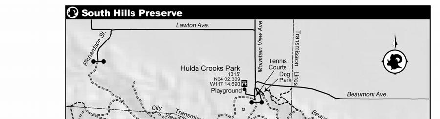
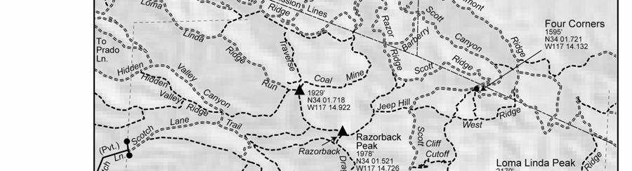
10 trip 7.A South Hills Preserve Jedi Trail Distance 5 miles (out-and-back) Hiking Time 2.5 hours Elevation Gain 800 Difficulty Moderate Trail Use Cyclists, equestrians Best Times October April Agency Loma Linda Public Works Department (909) Optional Map Redlands 7.5 DIRECTIONS From Interstate 10, exit at Mountain View Ave. and drive south through Loma Linda for 2 miles. At the entrance of Hulda Crooks Park, veer left and park on the east side of the basketball and tennis courts. The trail starts at the south end of the parking lot. On the opposite side of the courts is an attractive playground with picnic benches and a restroom. The hills on the south side of Loma Linda represent the last gasp of the Peninsular Ranges, which extend from San Jacinto south into Baja California. Thrust up from an ancient lakebed by the confluence of the San Jacinto, Banning, and Loma Linda Faults, the sedimentary hills are now laced with an intricate web of trails and dirt roads. They are tremendously popular with mountain bikers, but also draw large numbers of hikers of all abilities. The most popular route ascends Scott Canyon to the narrow, winding Jedi Trail. The ridge at the end of the trail offers spectacular views in all directions. Our favorite time is winter, when the grass grows green and the snow-capped peaks ringing the basin stand out in the crisp air. Hulda Crooks Park is named in honor of an American mountaineer and long-time Loma Linda resident. Known as Grandma Whitney, she scaled California s tallest peak 23 times between the ages of 65 and 91. The City of Loma Linda established the South Hills Preserve in It is presently the Wild West of city wilderness parks. The trailheads are unmarked and one key entry point is still posted with a defunct no trespassing sign. Some of the trails are extremely steep with dramatic dropoffs or severe erosion. Teams of daredevil cyclists, acting on their own authority, are often seen building new jumps and obstacles. Although the park is legally closed to motorized vehicles, the closure is not yet signed and the southern portion of the preserve commonly buzzes with the whining of motorbikes that are tearing up ridges and causing erosion. The boundaries of the city land are unmarked and many trails lead out of the preserve onto private land, but all of the trails have had a long tradition of use by hikers and cyclists dating back long before the city acquired the land. The hills are a vital wildlife corridor and are home to coyotes and rattlesnakes as well as deer, redtail hawks, and an occasional cougar. As you would anywhere, watch your step and travel in a group for safety. From the far (south) end of the parking area, walk south toward a concrete dam and debris basin on a wide dirt road. Skirt the left edge of the basin and follow the dirt road up Scott Canyon. Numerous side trails tempt the curious, but this trip stays on the main road along the canyon bottom. In 1.1 mile reach Four Corners where the Scott Ridge and Beaumont Ridge roads meet the canyon. Continue up Scott Canyon. In another mile, the road deteriorates to a winding rutted trail that mountain bikers find challenging and delightful. Stay on the main path as you pass trails entering side canyons. In another 0.5 mile, emerge at a trail junction atop Shotgun Ridge, where you can catch your breath and admire the views. The simplest option is to return the way you came. However, the adventurous hiker will investigate one of the countless more interesting alternatives. One popular route is to turn left and climb to Loma Linda Peak, the high point of the preserve. Veer left down the narrow West Ridge Trail. When the West Ridge ends at a power line service road, continue straight onto the Beaumont Ridge Road, which leads north and then northwest back to the trailhead. This option has great views and is scarcely longer. Another great route is to turn right and follow Shotgun Ridge, named for a former landowner known for dramatic methods of dissuading trespassers. Climb the aptly named Wall and continue along Dragon Back to the short but dramatic Razor Back that leads to Razorback Peak. Turn left and follow the Loma Linda
11 Ridge Run to a second hilltop, then turn right and drop down the Coal Mine Trail on the way back to the trailhead. This option is also scarcely longer, although it crosses some wild and poorly signed portions of the preserve. 07-IMG_8349-southhillspreserve.JPG San Bernardino Peak overlooking the Fault View Trail in South Hills Preserve

12
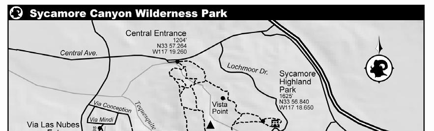
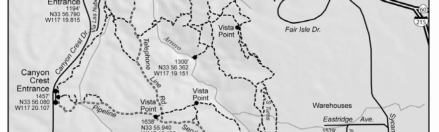
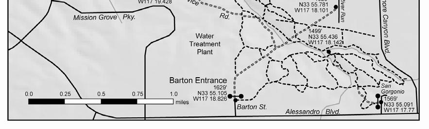
13 trip 7.B Sycamore Canyon Wilderness Park Distance 2-10 miles (countless options) Hiking Time variable Elevation Gain modest Difficulty Easy - Moderate Trail Use Cyclists, dogs allowed Best Times October April, ½ hour before sunrise to ½ hour after sunset Agency Riverside Parks, Recreation & Community Services Department (951) Optional Map Riverside East 7.5 DIRECTIONS The City of Riverside recommends that visitors use the Central Entrance, located on the south side of Central Ave. one mile west of the 60/215 Freeway. This entrance has a large parking area and a drinking fountain. Street parking is also available at entrances on Barton St, Via Las Nubes, and Sycamore Highland Park. Regular visitors will discover numerous other unofficial access points, although parking at these other entrances may be problematic. Riverside, founded in 1870, is one of the oldest cities in the Inland Empire. It is the birthplace of the southern California citrus industry and the home of many treasures, not the least of which is the Sycamore Canyon Wilderness Park. The park, owned by the California Department of Fish and Game and managed by the City of Riverside, protects nearly 1500 acres of habitat and watershed and offers an important wildlife corridor. It is a core reserve for the endangered Stephen s kangaroo rate. The wilderness park is laced with countless trails tempting the hiker to explore. It is extremely popular among mountain bikers, who consider it a prime riding location in the Inland Empire. Although the park can be enjoyed year-round, it gets very hot in the summer. Springtime is a particularly enjoyable time to visit and enjoy the abundant wildflowers. At present, the wilderness park has almost no trail markers. A first-time visitor would need extraordinary map reading skills to follow a particular route. Nevertheless, anyone with a reasonable sense of direction will be able to wander the trails and find the way back to the trailhead as long as he or she keeps an eye on the landmarks. Thus, instead of recommending a specific loop through the park, this trip simply describes some of the major features and encourages you to roam as far as you care to explore. You can readily choose 3-5 mile loops from any of the trailheads, or aim for an 8-10 mile loop encompassing the entire wilderness park. For example, from the Central Entrance, consider taking the left-hand trail and work your way up to Sycamore Highlands Park, then circle back on another of the trails. Overall, the east end of the park is the flattest, while Sycamore Canyon becomes quite deep to the northwest. The canyon presents a significant barrier to travel and is crossed by trails in only a limited number of locations. Plan your loop accordingly. Keep your eyes out for the abundant wildlife in the park. Snakes are not uncommon, so pay attention to where you place your feet. Wear shoes with good traction because some trails can be steep and slippery. While we have made a substantial effort to walk each trail (over 20 miles) and depict the trails accurately on the map, you can expect that some trails will vanish over times and others will be restored or created. Please stay on established paths.
14 07-IMG_0211-sycamorecanyon.jpg Sycamore Canyon Wilderness Park
15
16 trip 8.A Wiashal Trail Distance 3.5 miles (one way) or 6.6 miles (out-and-back) Hiking Time 2 hours Elevation Gain 600 (one way down) or 1700 (out-and-back) Difficulty Moderate or Strenuous Trail Use Cyclists, equestrians Best Times October April Agency Santa Rosa Plateau Ecological Reserve Optional Map Wildomar 7.5 DIRECTIONS This trip involves a car shuttle if you wish to hike it one-way. From Interstate 15 in Murrieta, exit southwest on Clinton Keith Rd. In about 1.6 miles, turn left (east) onto Calle Del Oso Oro. Then turn right (south) onto Calle Cipres, then immediately left onto Placer Creek St. At a T-junction, turn right on Single Oak Way. Leave a vehicle here. You will emerge through a gap between the houses. Finding your vehicle can be confusing at the end of the hike, so take some time to familiarize yourself with the trailhead. Return to Clinton Keith Rd. and continue 2.5 miles up to the Santa Rosa Plateau Ecological Reserve Visitor Center on the left side of the road. Park at the Visitor Center or in the clearing across the street. The Wiashal Trail, pronounced wee-uh-shawl, descends from the Santa Rosa Ecological Reserve to an open-space preserve in Cole Canyon at the edge of Murrieta. It is the steepest trail in the reserve and has some areas with poor traction; a hiking pole and good sense of balance are helpful. Remarkably, hard-core mountain bikers love this trail and have nicknamed it the Superman Trail. The trail features great views and some of the oldest chaparral in Southern California. The route is not marked on the topographic map and mostly falls beyond the edge of the reserve map. The signed upper end of the Wiashal trail starts at the junction of Clinton Keith Rd. and the dirt road leading to the Visitor Center parking. The trail leads north parallel to Clinton Keith Rd. for 0.3 mile to a second trailhead at a dirt lot opposite Avenida la Cresta. Much of this area burned in the 1981 Turner fire, but the next stretch has not burned in many decades and contains some of the oldest hoaryleaf ceanothus plants in Southern California. This plant requires fire for the seeds to grow and lives for about a century if not burned. Scrub oak, sugarbush, and many other chaparral species are common along other stretches of the trail. The trail passes along rolling hills with many ups and downs. In another 1.4 mile, a sign indicates a trail leading left for 0.1 mile to an overlook with great views. 0.7 mile beyond, reach a junction with another trail leading left for 0.1 mile to a second overlook where you can look over the town of Murrieta. Adjacent to this junction is a boulder named Eagle Rock. Under the right light, the resemblance is uncanny. Beyond Eagle Rock, the rolling terrain ends and the trail plunges steeply to town. In 0.9 mile, reach a gate at the preserve boundary. This is a good turnaround spot for a round-trip hike. Otherwise, continue to a T- junction in Cole Canyon and turn left. Wander through a maze of paths, generally tending north as much as possible before turning west to reach Single Oak Way in 0.3 mile.

17 08-IMG_9984-eaglerock.JPG Eagle Rock
18 trip 9.A Idyllwild Nature Center Loop Distance 2.5 miles (loop) Hiking Time 1.5 hours Elevation Gain 600 Difficulty Moderate Trail Use Dogs, good for children Best Times All Year, closed Mondays; 9 4:30 Agency Riverside Country Regional Park and Open-Space District Optional Map Tom Harrison San Jacinto Wilderness DIRECTIONS From the Idyllwild Ranger Station drive west 1 mile on Highway 243. Turn left (south) into the Idyllwild Nature Center. Pass through a gate and proceed 0.3 mile to the Nature Center parking at the end of the road. The Idyllwild Nature Center is located on the west side of Idyllwild at the site of an ancient Cahuilla Indian village. It features nature programs, camping, picnicking, a short interpretive Nature Trail, and a longer Loop Trail. It is a good place to take a ramble, learn about mountain ecology, and enjoy fine views of Tahquitz Peak. The Nature Center is open Tuesday Sunday from 9-4:30. Day use fees are $2 for adults and $1 for children. Begin your visit at the Nature Center to pay your day use fee and pick up a map and trail guide. The exhibits at the Nature Center are unusually good and appeal to all ages. School and youth groups can arrange environmental education programs with advanced notice. The Nature Center is linked to Idyllwild Park; both are part of the Riverside County Regional Park system. The southern section of the park features a popular campground and picnic area. Call (800) for reservations. This loop begins behind the Nature Center. Look for a sign for the View Point and Campground. Follow the trail southeast for 0.1 mile to the View Point atop a small hill, where you can enjoy a bench or admire the granite ramparts of Tahquitz Peak. The open forest is notable for gigantic tree-like pink-bracted manzanitas (Arctostaphylos pringlei ssp. drupacea) as well as oaks and Coulter pines. Continue 0.1 mile to a junction with a trail leading to the campground. Stay right and hike west 0.2 mile to an unmarked junction near a gigantic oak. The right fork leads back to the Nature Center, but we take the left fork, cross Lily Creek, and reach a signed junction in 0.1 mile on the far side of the creek. From here, we make a loop. The easiest way to go is counterclockwise. Start up the right fork, variously labeled Summit Trail or Steep Trail. Follow the switchbacks 0.5 mile as they climb almost but not quite to the highest point of the hill at the edge of the park. The best views of the trip are found in this area. Follow marker posts down 0.5 mile to a four-way junction at the edge of the campground. Turn left and follow the Hillside Trail, which generally contours along the slope, passing some large granite blocks that are popular with boulderers. In 0.6 mile, arrive back at the junction beside Lily Creek. Hike back across Lily Creek, then turn left to shortcut back. Go 100 yards to a T-junction, then turn right and go another 100 yards back to the Nature Center. VARIATION: The easy 0.7 mile Yellow Pine Forest Nature Trail starts at a sign in front of the Nature Center. Ten numbered posts are described in the trail guide, available at the Nature Center and the trailhead. One of the highlights of the trail is the bedrock mortars, called metates, where Cahuilla Indians ground acorns from black oaks.

19 VARIATION The Perimeter Trail starts near the gate near Highway 243 at the north entrance to the Idyllwild Nature Center. Follow it east, then south for 1 mile to the campground entrance road just outside the fee station. Optionally, you can continue south past the amphitheater, negotiate a narrow section along a tributary creek, follow an easement outside the park fence line to the southeast corner of the park, then join the Hillside Trail and Nature Trail to make a return loop. 09-IMG_2867-idyllwildparkmetates.JPG Bedrock Mortars along Nature Trail
20
21 trip 9.B Panorama Point Distance 0.8 miles (loop) Hiking Time 20 minutes Elevation Gain 100 Difficulty Easy Trail Use Good for children, dogs, wheelchair accessible Best Times May - October Agency Mt. San Jacinto State Park Optional Map Tom Harrison San Jacinto Wilderness DIRECTIONS From Highway 243 near mile marker 243 RIV 9.75, 200 yards east of Alandale Ranger Station, turn northeast on the paved Azalea Trails Rd. In 0.1 mile, veer right into the Stone Creek Campground. Register at the Iron Ranger, then drive to the top of the campground and park at the trailhead near site #16. The San Jacinto area is peppered with delightful mountain campgrounds. Stone Creek Campground offers not only camping, but also a short nature trail to Panorama Point. The views from the point are now somewhat obscured by the fast-growing forest, but the trail is nevertheless pleasant and features excellent interpretive signs. Listen for the chickadees and keep an eye out for squirrels and lizards. The dirt path is wide and well-graded so sturdy wheelchairs can reach the vista. Stone Creek Campground charges $15 for a campsite, or $5 for day-use visitors. Call (800) or see for reservations. Walk north from the trailhead past the Panorama Point Trail sign. The trail is situated at nearly 6000, which is a transition zone in the forest. The manzanitas, oaks, ponderosa pines, and Coulter pines of the lower mountain begin giving way to sugar and Jeffrey pines. In 0.3 mile, reach an unmarked junction. Stay left and curve around 0.1 mile to Panorama Point. On a clear day, you can see all the way to the Pacific Ocean. Return to the junction and complete the loop back to the campground. VARIATION: The 2.8-mile Stone Creek Trail climbs 800 from Stone Creek Campground up to Marion Mtn. Campground. It passes the site of a historic sawmill en route. Extensive logging is presently occurring in the area and it is possible that the logging may affect the trail. With a car or bicycle shuttle, this trip can be done as a one-way excursion. Dogs and bicycles are prohibited on this trail. The Stone Creek Trail crosses Mt. San Jacinto State Park. Obtain a free day-use wilderness permit near the entrance of Stone Creek Campground. The trail starts at the southeast end of the campground near site #7 N W ). It leads east-southeast, following the path of a defunct nature trail. In 0.2 mile, reach a dirt logging road. Turn left and continue east for 0.5 mile to a junction. Stay left again and climb for 1.0 mile to a sign for the Stone Creek Trail. Turn left (north) onto the trail and reach Sawmill Flats in 0.1 mile (N W ). A disintegrating stone structure and heavy metal cables mark the site of the former mill. Continue north for 1.0 miles to a junction with the Marion Mtn. trail and a dirt road (see Trip 9.6) (N W ). Follow the dirt road down to the Marion Mtn. campground near site #11.
22 trip 10.A Hurkey Creek Distance 4.5 miles (loop) Hiking Time 2.5 hours Elevation Gain 500 Difficulty Easy Trail Use Good for children, dogs, cyclists, equestrians Best Times March June, September - November Agency Riverside County Park and Open-Space District Recommended Map Idyllwild 7.5 DIRECTIONS From Highway 74, 3.4 miles southeast of Mountain Center and just before mile marker 074 RIV 62.75, turn left (east) onto Apple Canyon Rd. Then turn immediately left into Hurkey Creek Park. After paying your day-use fee of $2/person and obtaining a park map, proceed 0.3 mile to the north end of the campground and park near the outhouse across from site #128. Hurkey Creek is a cool mountain stream flowing down from the granite ramparts of Tahquitz Peak. Riverside County has constructed a fine campground along the creek opposite Lake Hemet at the northern edge of the Garner Valley. A trail leads north from the campground, following the creek before connecting to a maze of other paths in the hills. This trip describes a loop that returns on another of the paths. The trip is a fine way to enjoy the splendor of the Desert Divide without enduring the steep climbs. It features a spectacular forest of ribbonwood and spring wildflowers. Some hikers will prefer making a shorter trip (up to two miles) out and back along the creek. Springtime is the ideal season to visit, when the creek is running and the days are not yet too hot. Campsites are available first-come, first-served or by reservation at (951) The cost is $20. Large group sites are also available by reservation. Families with younger children will love the impressive park near the campground entrance. Showers are also available. Free camping can be found at a number of excellent yellow-post campsites just up Apple Canyon Rd. The trail, actually an old fire road, starts at an unmarked gate by site #130 (GPS N W ). It leads north along the west side of the creek past ribbonwood and Jeffrey pines. Numerous side paths bring you down to frolic by the water. A single-track path soon crosses the trail, but this trip continues north. In 0.9 mile, reach an unmarked fork (GPS N W ). This is a good turnaround point for a short hike. The left branch leads to May Valley Road via a popular mountain bike route called Exfoliator, but this trip turns right and crosses Hurkey Creek on a wooden bridge before climbing onto a plateau. Upon reaching the plateau in 0.4 mile (GPS N W ), our trail turns abruptly right (southeast), but a lesser-used single-track continues north. Hike through the lonely sagebrush country in an area known as K Flat. From here, you can enjoy great views of the granite buttresses on Tahquitz Peak, Red Tahquitz, and the northern Desert Divide. The trail soon turns south and begins dropping, offering more good views of the fine Garner Valley and of Thomas Mtn. beyond. It passes beneath a canopy of giant ribbonwood plants; this section is known as the Tunnel of Love. In 1.5 miles, reach a dirt road (GPS N W ). Turn left, then left again, and hike 0.4 miles to the paved Apple Canyon Rd. This area is a tangle of dirt roads, but any road leading southeast will eventually get you to the pavement. If you haven t prepositioned a bicycle or second vehicle, walk back to the trailhead. Turn left and follow Apple Canyon Rd. a mile back to Hurkey Creek Campground, passing the private Apple Canyon Center along the way. Then follow the campground road to your vehicle.


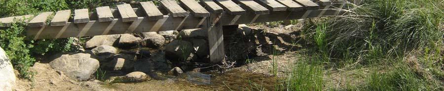
23 Crossing a bridge over Hurkey Creek 10-IMG_3334-hurkeycreek.JPG VARIATION Hard-core mountain bikers will enjoy exploring the intricate network of fire roads and single-track in the area. See the link below for a map from Mountain Bike Bill. Riders flock to this area for the 24 Hrs of Adrenaline race, in which they make as many circuits of a 9-mile course as they can in one day.
24 trip 10.B South Fork of the San Jacinto River Distance 5 miles (out-and-back) Hiking Time 2.5 hours Elevation Gain 900 Difficulty Moderate Trail Use Dogs, equestrians, suitable for backpacking Best Times October - May Agency San Bernardino National Forest (Idyllwild Ranger Station) Recommended Map Blackburn Canyon, Idyllwild 7.5 DIRECTIONS On highway 74 between Hemet and Mountain Center, park at the large Caltrans cinder bin lot at mile marker 074 RIV If you are coming from the east, you will see a sign immediately before the lot reading South Fork Trailhead 2E17. The South Fork of the San Jacinto River tumbles out of the Lake Hemet Reservoir and cuts a gorge down the west slopes of the San Jacinto Mountains south of Highway 74. The South Fork Trail (2E17) leads from the highway over a low divide and down to the river. It is particularly attractive on a cool day in April and May when the chaparral and wildflowers are in bloom. The trail also draws fishermen to try their luck on this secluded portion of the river. Wildlife love the lushly vegetated banks, though the algae-filled pools are not particularly appealing for water play. Congress passed the Omnibus Public Land Management Act of 2009, establishing the South Fork San Jacinto Wilderness to protect this land. The trail starts at a post on the south side of the parking area (GPS N W ). It climbs 300 over 0.5 mile to reach the low ridge south of the highway. The slopes are covered in ribbonwood and other chaparral. Enjoy the views of Tahquitz Peak and Marion Mtn. from the ridge. The trail contours along the southwest-facing slopes for 1.6 miles, offering impressive views into the rugged canyon. Watch for quail along the trail and vultures circling overhead. This section would be oppressively hot in the summer. The trail then abruptly drops the last 0.4 miles to the river (GPS N W ). This last portion was rocky and somewhat brushy in May Stepping stones cross the river; they are usually straightforward but could be difficult during times of high flow. A few clearings large enough for tents can be found just up the hill on the far bank. VARIATION The South Fork Trail continues up to Rouse Ridge on the south side of the river. This is a trail to nowhere, connecting only to a long, obscure, bumpy, and very scenic dirt road on the ridge. It may be attractive to those looking for a longer workout. Peak baggers also use the trail to access Rouse Hill, a fairly insignificant bump with fine views. The trail climbs steep switchbacks shaded under oaks and bigcone Douglas fir. In 1.7 miles, it reaches an old jeep track on the ridge, now closed to motorized vehicles. Continue 0.4 mile to the junction (GPS N W ) with the Rouse Hill Road (5S15), which connects the Thomas Mountain Road to the Cranston Fire Station. If you wish to visit Rouse Hill, turn right and follow the road 1.6 miles to a turnout, then pick a path through the light brush for the last few hundred yards to the summit (GPS N W ). Alternatively, it is possible to shortcut part of the road by hiking over a hill to the west where the trail meets the jeep track.
25 10-IMG_3400-southforkview.JPG Marion Mtn. and Tahquitz Peak from the South Fork Trail
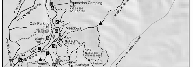
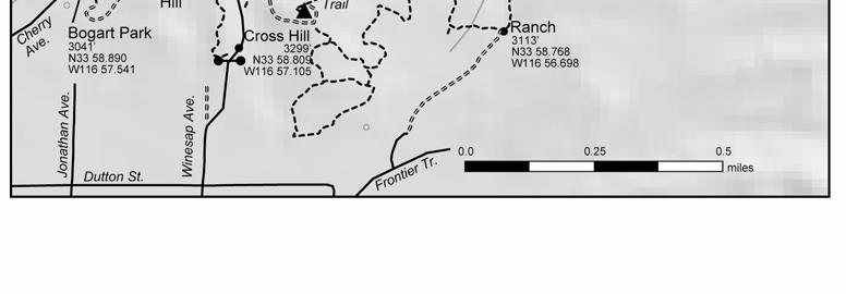
26 trip 14.A Bogart Park Loop Distance 3.5 miles (loop) Hiking Time 2 hours Elevation Gain 600 Difficulty Easy Trail Use Equestrians, dogs Best Times September May. Open 8:00 A.M. sunset. Closed Tue-Wed. Agency Riverside County Regional Park & Open-Space District Optional Map Beaumont 7.5 DIRECTIONS From Interstate 10 in Beaumont, exit north on Highway 79 (Beaumont Ave.). In 2.4 miles, turn right on Brookside Ave. In 0.8 mile, turn left on Cherry Ave. Proceed 1.5 miles to the park entrance and pay your day use fee (presently $2 for adults). Ask for a pamphlet describing the Nature Trail. The road changes name to International Park. Continue 0.3 mile and park at the signed Oak Parking area on the left. Bogart Park is a 414-acre parcel at the north end of Cherry Valley in the foothills of the San Bernardino Mountains managed by the Riverside County Regional Park and Open-Space District. The park offers hiking, picnicking, and camping along the oak-shaded banks of Noble Creek. It is beautiful in many seasons, but especially attractive in late March when the cherry trees blossom. Bogart Park is a favorite destination among locals, but has faded into obscurity for most residents of Riverside County. Its origins lie in the Great Depression, when the community banded together to host a Japanese Cherry Blossom Festival. The first festival, held March 30, 1930, attracted 32,000 visitors to the tiny village of Beaumont. Dr. Guy Bogart, president of the Beaumont Rotary Club, went looking for a more suitable location for the next year s festival and identified the canyon that is now the site of the park. The government lacked the money to purchase the land, so 25 local businessmen joined together to buy the property for the county in time for the 1931 event. The land was named International Park, dedicated to international peace. Unfortunately, World War II and the Cold War soon ended the affection for Japan and hopes for world peace. In 1957, the county renamed the park in honor of Dr. Bogart. The park features an elaborate system of poorly marked trails. This trip makes a counterclockwise loop around the park. Identifying all of the unmarked junctions is difficult, but so long as you stay on trails and don t veer far away from the paved road through the park, you will eventually get where you want to go. Many long trails, popular among equestrians, veer off into the hills. Turn back if you find yourself straying onto these trails, unless you are looking for a longer ramble. The trail map available at the entrance station is cute but has only the loosest relationship with the actual trails. A sign at the southwest corner of the Oak Parking area indicates the start of the Nature Trail. Hike southwest on the trail past numbered sign posts. The key is available at the entrance station. The trail immediately splits, then soon rejoins to cross Noble Creek. It then splits again. The two branches run close by to each other, so take either one. In 0.2 mile, the branches rejoin. You could follow the other branch back for a half-mile nature loop, but this trip continues straight. In 0.1 mile, turn left at a fork. Descend 0.1 mile to International Park Rd. by the entrance station. Cross the road and climb steeply up a trail on the south side for 0.1 mile to reach a dirt road by a stable. Turn left and follow the road 0.4 mile up to the top of David Starr Jordan Peace Hill, now marked with a green water tank. The hill was named for a former president of Stanford University, a peace activist and explorer of the wilderness. Join a trail that passes around the right side of the tank and descends to a paved park road just north of a gate in 0.3 mile. Turn left and hike 0.1 mile up the road. Shortly before reaching the parking lot for a small lake, turn right onto a marked trail. The trail crosses the creek below a dam, then climbs steeply. Stay right at a fork; the left path descends to the lake. In 0.1 mile, reach a dirt road. Turn right and follow it 0.2 miles as it


27 corkscrews up to the top of Cross Hill. A stone foundation marks the site where a large cross once stood. This hill offers the best views of the trip. Descend the stone-lined Candlelight Trail that switchbacks down the north side of the hill to rejoin the road in 0.2 mile at a complicated 5-way junction. A horse trail leads to the right (east). A dirt road makes a hairpin turn here and both sides depart to the left (west). But this trip goes straight ahead on a trail to the north. In less than 0.1 mile, go left at a junction. In 0.2 mile, reach a 4-way junction near the Meadows parking area. Families might enjoy turning left down to the Meadows, where a playground is located beside the field. However, this trip goes straight to a T-junction near a paved road, then turns right. Follow the trail north for 0.7 mile, passing above a picnic area and campground, until you reach the Equestrian Campground. Turn right on a dirt road and hike through the Creekside Group Camp beneath the mature canyon oaks. Pass a gate indicating road closure; this does not apply to foot traffic. In 0.3 mile, the road crosses Noble Creek. You could continue exploring further upstream, but this trip makes a sharp left turn onto a trail that returns to the south on the west side of the creek. The trail forks, but both branches run parallel and rejoin near the south end of the campgrounds. In another 0.1 mile, arrive back at the Oak Parking where you began. 14-P bogartcrosshill.JPG Bogart Park from Cross Hill
28
29 trip 14.B Bogart Park North Distance 5.5 miles (loop) Hiking Time 3 hours Elevation Gain 1200 Difficulty Moderate Trail Use Equestrians, dogs Best Times September May. Open 8:00 A.M. sunset. Closed Tue-Wed. Agency Riverside County Regional Park & Open-Space District Optional Map Beaumont 7.5 DIRECTIONS From Interstate 10 in Beaumont, exit north on Highway 79 (Beaumont Ave.). In 2.4 miles, turn right on Brookside Ave. In 0.8 mile, turn left on Cherry Ave. Proceed 1.5 miles to the park entrance and pay your day use fee (presently $2 for adults). Ask for a pamphlet describing the Nature Trail. The road changes name to International Park. Continue 0.5 mile. Where the main road turns sharply right, continue straight (north) on a campground road. Park before a gate at the equestrian camping area in 0.4 mile. This loop trip is a favorite among local equestrians and hikers. It features a walk along Noble Creek beneath the shady oaks, followed by a vigorous climb to a hill offering sweeping vistas. Plentiful flakes of mica along the fire roads add a special sparkle to the trip. See Trip 14.A for more information about Bogart Park. Hike north from the equestrian campground up a dirt road along Noble Creek. In 0.2 mile, reach an ominous sign warning that the canyon is closed. Park staff report that the canyon receives steady use and that the sign can be disregarded. Beyond the sign, the road crosses to the west side of the creek and continues north. Two trails parallel the road, one on each side. Take either the road or one of the trails, which eventually rejoin the road. In 0.3 mile, look for a trail on the left where the road veers right and begins switchbacking up the hill to the east. This loop will later return on the road. Take the trail, which follows the west side of the burbling creek, occasionally climbing around obstacles in the canyon. In 0.9 mile, reach a T-junction. The path to the left leads 100 feet to a dirt road, but this trip turns right, crosses the creek, and follows begins climbing to the east. It follows the bed of an abandoned road, which has been overgrown with chaparral such that only a single-track trail remains. In 1.9 mile, reach a fire road at a saddle. Turning left on the fire road would lead over to the Banning Bench, but this trip turns right (southwest) and circles back. In 0.6 mile, reach the top of a hill where a picnic bench invites you to enjoy the terrific views, from San Jacinto to Yucaipa Ridge to the hills around Lake Perris to the ranches of Cherry Valley. A trail leads south down a ridge to the Meadows picnic ground in Bogart Park, but this loop continues west down the fire road. In 1.0 mile, reach the bottom of Noble Canyon, where the road turns south and returns to the equestrian campground. *** investigate land ownership north of Bogart Park
30 14-bogartnobleoaks-P JPG Noble Canyon
31
 30 minutes Flat Easy Dogs, good for children October - April BLM (Palm")
32 trip 14.C Dos Palmas Preserve Distance Hiking Time Elevation Gain Difficulty Trail Use Best Times Agency Optional Map 1 mile (loop) 30 minutes Flat Easy Dogs, good for children October - April BLM (Palm Springs Field Office) jointly with the Center for Natural Lands Management n/a DIRECTIONS From Highway 111 on the northeast side of the Salton Sea directly opposite the Salton Sea State Recreation Area Visitor Center, turn east on Parside Dr.Go 1.8 mile to a T- junction, then turn right (south) on Desert Aire Rd. In 0.4 mile, veer left onto the good dirt Powerline Rd. In 0.6 mile, turn left again onto Dos Palmas Rd. Proceed 1.7 mile to the trailhead parking on the right side of the road immediately before a gate. In 1862, William Bradshaw built the first road across the desolate deserts of Riverside County to the Colorado River, establishing a stage route from San Bernardino to the gold mines of La Paz, Arizona. His route followed a series of springs that friendly Indians had shown him. The best of these springs, a sparkling blue pool framed by twin palm trees, took the name Dos Palmas. The unlikely oasis in the midst of the alkali desert is nourished by water forced to the surface along the fractures of the San Andreas Fault. The twin trees have multiplied to hundreds, in three distinct groves. This trip makes an easy but scenic loop through the San Andreas grove of palms. Consider a visit to the Salton Sea across Highway 111 or a drive along the Bradshaw Trail to round out your trip to this fascinating corner of the desert. Backcountry Adventures Southern California, by Massey and Wilson, is highly recommended for those considering the Bradshaw Trail or other 4WD excursions in the Inland Empire. Hike east along the signed San Andreas Trail, which is lined with rocks and timbers. In 0.3 mile, cross an old dirt road and enter the oasis. The trail loops through jungle-like grove, crosses a bridge over a creek, and emerges at the dirt road. Turn left and walk 0.1 mile northwest along the road until you reach the San Andreas Trail. Turn right and return to the trailhead. For a longer visit, you can also walk east past the gate and up the roads to Dos Palmas. The rancho is now closed, but the oasis is open to visitors on foot. 14-P dospalmas.JPG California Fan Palms at the San Andreas Grove
33 trip 15.A Split Rock Distance 2 miles (loop) Hiking Time 1.5 hours Elevation Gain 500 Difficulty Easy Trail Use Good for kids Best Times October - April Agency Joshua Tree National Park Recommended Map Trails Illustrated Joshua Tree, or Queen Mountain 7.5 DIRECTIONS From the main Park Blvd. through Joshua Tree National Park east of the Jumbo Rocks campground 0.1 mile east of mile marker 7, turn north at a sign for Split Rock. Follow the good dirt road 0.5 mile to the Split Rock picnic area at the end. The Split Rock Loop is an enjoyable ramble among Joshua Tree s humongous monzogranite boulders. Rock climbers flock to this area, and it is likely that you will see them clinging to the walls on a pleasant day. The terrain is complicated and the trail is not always marked as well as it could be, so this trip is not recommended for inexperienced navigators. From the Split Rock picnic area, hike north on a poorly defined trail around the left side of the house-sized Split Rock. The back side of the overhanging rock forms a cave, with a small tunnel at the rear. Continue north and descend into a valley dotted with Mojave yuccas. This section of the trail can be particularly indistinct in places. In 0.4 mile, reach a sign indicating EC (Eagle Cliffs) to the right and SL (Split Rock Loop) to the left. Follow the trail to the left, which leads southwest, then south. In another 0.6 mile, reach another clump of huge granite boulders. Look to your right for a formation aptly named Tulip Rock. The trail continues south for 0.3 mile, then abruptly turns left and meanders through the boulders and cliffs back toward the picnic area. Pass another vista of Tulip Rock, then enter a wash leading through a gap between the rocks. If you look back just before entering the wash, you may see a rock crag with a window and another smaller formation with an arch. Posts mark the exit from the wash and the path back to the southwest side of the Split Rock picnic area.


34 15-IMG_8850-splitrockarch.jpg Arch and window along Split Rock Loop 15-IMG_8837-splitrocktulip.jpg Tulip Rock
35 [note: this trip should replace the variation in Trip 15.12] trip 15.B Mt. Inspiration from the Coachella Valley Distance 14 miles (out-and-back) Hiking Time 9 hours Elevation Gain 4600 Difficulty Strenuous Best Times October - April Agency Joshua Tree National Park Required Map Trails Illustrated Joshua Tree, or Keys View 7.5 DIRECTIONS Exit Interstate 10 at Ramon Rd. Drive east (on the north side of the freeway) for 4.5 miles, then turn left on Thousand Palms Rd. Proceed nearly 5 miles to its end at Dillon Rd. Two minor roads continue on the opposite side of Dillon Rd. Take the right road, which starts off as poor pavement and eventually becomes good dirt. Stay on the main road as you pass many spurs. In 4 miles, reach a junction about a mile east of Fan Hill. A dirt road leads south and a fainter old jeep road leads north. Park here. If you reach the end of the main road at an aqueduct service area littered with unbelievable quantities of shotgun shells and broken glass, you have gone 0.25 mile too far. Any mountaineer who spends enough time in the Joshua Tree area will inevitably start to wonder about the steep south wall of the Little San Bernardino Mountains. From the Keys View overlook, an intricate maze of ridges and canyons seems to spiral down into the desert below. One of the classic cross-country adventures in this area is to climb Mt. Inspiration the hard way, from the Coachella Valley. This demanding trip visits an old mine site and offers rugged, desolate beauty. Watch for bighorn sheep, which are known to haunt these seldom-visited slopes. Maps of this area are incomplete. The majority of miles on this trip follow an old mining road to a point just beneath Hidden Gold Mine. The Trails Illustrated map does not show the road at all, and the Keys View topo represents the road as a trail ending long before the mine. Both maps place the mine too low in the canyon. From the parking area, hike north on an old dirt mining road. In 250 feet, pass a post marking the road closure at the wilderness boundary. Follow the road as it hugs the east edge of a huge alluvial fan covered with creosote bushes. In about 3 miles, the road veers right (east) into a narrower canyon and soon passes a cable and rock barrier marking the former wilderness boundary. In another 0.8 mile, the road swings left into the first canyon on the north. Continue 1.1 mile to the end of the road. The road deteriorates near the end and can become indistinct. Continue hiking cross-country up the canyon, staying right at a fork. The canyon narrows and turns back to the left. At another fork (GPS coordinates N W ), veer right up a tributary canyon. The upper reaches of this canyon become unpleasantly steep and loose; the thought of carrying heavy loads of ore down this canyon gives one pause. Pass scattered beams, then a shallow excavation, then the partially collapsed site of two adits. Scramble up a short distance to the ridge, which soon becomes easier. The desert scrub gives way to junipers. You may find traces of a prospectors trail leading up the ridge. As you climb, breathtaking panoramas open up beneath you extending from the Salton Sea past the Santa Rosa and San Jacinto Mountains to San Gorgonio. After 1100 of climbing, pop over the lip to the Keys View overlook, where you may startle tourists who have driven to the site. At this point, you have traveled 6 miles and climbed You might choose to turn back here and retrace your steps. For the complete mountaineering experience, continue to the top of Mt. Inspiration. From the west end of the parking lot, follow a climbers trail up the hill, down to a saddle, and up again. Skirt the north edge of the next bump, Point 5558, and continue to a
36 third bump, which is the true peak. A benchmark reading Inspiration can be found atop the bouldery summit. Return the way you came, or follow the ridge descending south from Point The ridge spits and any of the branches can be negotiated, but steep dropoffs near the bottom of all of the ridges require some routefinding to circumvent. The mining road can be found just below the ridges. 15-IMG_0139-inspiration.JPG Morning light from Keys View, with San Jacinto on the horizon
37 trip 15.C West Side Loop Distance 4.5 miles (loop) Hiking Time 2.5 hours Elevation Gain 900 Difficulty Easy Trail Use Equestrians Best Times October - April Agency Joshua Tree National Park Recommended Map Trails Illustrated Joshua Tree, or Yucca Valley South 7.5 DIRECTIONS From Highway 62 in Yucca Valley, turn south on Joshua Lane at the sign for the Black Rock Campground (opposite where Highway 247 intersects 62, 0.4 mile east of mile marker 062 SBD 12.00). Follow Joshua Lane as it winds east then back south, and then reaches a T-junction in 4.4 miles. Turn right, then immediately left on Black Rock Canyon Rd., which leads into the campground. Park at the ranger station. The West Side Loop circles the hills to the southwest of Black Rock Campground. It is the newest addition to the extensive network of trails from Black Rock Campground. In our opinion, it lacks some of the diversity and splendor of the Panorama Loop (Trip 15.1), but it is nonetheless quite enjoyable and worthy of a hike if you are a repeat visitor. The entire area is rich with Joshua trees, Mojave yuccas, nolinas, junipers, pinyon pines, and many species of cactus. Walk west from the ranger station toward the low hills. At the edge of the campground, slightly south of the ranger station, find the sign marking the beginning of the West Side Loop Trail. Walk west 100 yards to another sign for the West Side Loop where the trail forks. This description assumes a clockwise circuit with most of the elevation gain near the beginning, so turn left (south). Hike along the back of the campground. Pass a junction with an old trail coming in from site #30 and join a dirt road. Follow the road as it veers left near a water tank, then immediately turn right onto a trail. In 0.4 mile from the start, reach a junction where a sign indicates the West Side Loop to the right. Follow the trail along the edge of the hills for 0.6 mile. At another signed junction in a wash, a horse trail leads down, but the West Side Loop goes up another 0.6 mile to a low saddle in the hills. Use trails lead north and south from the saddle into the hills. The trail south follows the crest of the hills to Warren Point (see Trip 15.1). But the West Side Loop continues west, undulating as it crosses a number of minor gullies before dropping steeply into Little Long Canyon. There are good views of San Jacinto and San Gorgonio looming beyond the desert slopes. In 0.6 mile, reach the bottom of the wash marked with another sign for the West Side Loop. Turn right and walk down the wash for 0.3 miles to a junction with another wash. The Little Long Canyon hiking corridor leads 1.1 miles up this second wash, but our loop continues downhill (north). In 0.4 mile, exit the wash to the right. In another 0.1 mile, reach a junction. The Boundary Trail West goes left (west), but our loop stays right and climbs eastward toward a second low saddle. Cross the saddle in 0.5 mile, then pass two junctions with the High View Nature Trail (Trip 15.D). In 0.9 mile, arrive back at the signpost at the edge of Black Rock Campground.
38 15-P westsideloopsanjac.JPG San Jacinto s North Face from the West Side Loop
39 trip 15.D High View Nature Trail Distance 1.4 miles (loop) Hiking Time 1 hour Elevation Gain 400 Difficulty Easy Trail Use Good for kids Best Times October - April Agency Joshua Tree National Park Recommended Map Trails Illustrated Joshua Tree, or Yucca Valley South 7.5 DIRECTIONS From Highway 62 in Yucca Valley, turn south on Joshua Lane at the sign for the Black Rock Campground (opposite where Highway 247 intersects 62, 0.4 mile east of mile marker 062 SBD 12.00). Follow Joshua Lane as it winds east then back south, and then reaches a T-junction in 4.4 miles. Turn right, then immediately left on Black Rock Canyon Rd., which leads to the campground. Enter the campground and stop at the ranger station to request an interpretive pamphlet for the nature trail. Then return to the campground exit and turn left (west) at a sign for the Horse Camp. Proceed 0.7 mile to the end of the road. This aptly-named nature trail makes a loop around the rich Joshua tree woodland southwest of Black Rock Campground. 23 interpretive markers along the path introduce the visitor to the botany and geology of the park. Ask at the Black Rock ranger station for a brochure explaining the markers. Supplies were limited at the time of this writing. This trail can also be reached from Black Rock Campground on foot by following the West Side Loop for 0.5 mile (see Trip 15.C). Follow the trail south from the parking area. At an immediate indistinct fork, stay left on the main trail to make a clockwise loop. Cross the West Side Loop trail in 0.1 mile, then climb 0.5 mile up the steep hill to the south for an excellent view and a summit register. San Gorgonio is the massive mountain to the west. Enjoy the gnarled old nolinas standing near the peak. Continue down to a saddle south of the summit. An unmarked trail leads south from this saddle up to the highest hills, but the nature trail turns right and descends into a small valley full of Joshua trees, junipers, and pinyon pines. In 0.7 mile, cross the West Side Loop trail again, then arrive back at the trailhead. VARIATION If you are looking for more, consider the unmarked South Park Peak trail on the north side of the parking area. This trail makes a 0.7 mile loop and gains 250 to the small peak overlooking Yucca Valley.
40 15-P highview.JPG High View Nature Trail
CIEC 9 PEAKS AWARD SUPPLEMENT POSSIBLE ROUTES FOR THE 9 PEAKS AWARD TRIP
 CIEC 9 PEAKS AWARD SUPPLEMENT POSSIBLE ROUTES FOR THE 9 PEAKS AWARD TRIP As you plan your trip, be aware of 3 regulations in this wilderness: 1. Camp only in designated campsites. 2. No campfires allowed.
Rogue Gorge (Mt. Stella) Roadless Area-- T30S R3E (primarily in portions of Sections 23, 26, 33, 34 & 35)
 Roadless Area-- T30S R3E (primarily in portions of Sections 23, 26, 33, 34 & 35)") Rogue Gorge (Mt. Stella) Roadless Area-- T30S R3E (primarily in portions of Sections 23, 26, 33, 34 & 35) Rogue River-Siskiyou National Forest--High Cascades Ranger District Upper, higher elevation trail
Rogue Gorge (Mt. Stella) Roadless Area-- T30S R3E (primarily in portions of Sections 23, 26, 33, 34 & 35) Rogue River-Siskiyou National Forest--High Cascades Ranger District Upper, higher elevation trail
Lava Mountain Trail Distance: Elevation Range: Trail Type: Difficulty: Season: Driving Distance: Driving Time: USGS Maps: Pros Cons
 Lava Mountain Trail Distance: 13.4 miles (including the side trip to North Star Lake) Elevation Range: 5900'-8330' Trail Type: singletrack Difficulty: moderate Season: late June-October Driving Distance:
Hiking Las Vegas.com
 Hike: Mt. Wilson via First Creek Canyon route Trailhead: First Creek marked Distance: 10 miles up and back Elevation gain: 3,400 feet Elevation of Peak: 7,070 feet Time: 7 to 9 hours (up and back) Difficulty:
Stephens State Park Trails
 TRAILS OF ALLAMUCHY MOUNTAIN & STEPHENS STATE PARKS Allamuchy Mountain and Stephens State Parks contain 28 marked trails providing access to diverse landscapes for walking, hiking, biking, bird-watching,
beach. Make the ford and follow the trail out to the junction with Red Creek Tr in an open grassy area.
 Description: This is a moderate to slightly strenuous 22.8 mile backpack (add 2.6 miles if you do the packless out and back to the Lion s Head) that will have you exploring nearly every thing that is The
Driving Time: 3 hours (allow extra time for stops)
") Scenic Byways loop This journey takes visitors through the eastern edge of Mt. Rainier National Park and along two of Washington s most beloved scenic byways, the Chinook Byway and the White Pass Scenic
Scenic Byways loop This journey takes visitors through the eastern edge of Mt. Rainier National Park and along two of Washington s most beloved scenic byways, the Chinook Byway and the White Pass Scenic
Skiing and Snowshoes on Un-groomed Fernan Saddle Terrain
 Skiing and Snowshoes on Un-groomed Fernan Saddle Terrain Three ski or snowshoe routes are available from the Fernan Saddle Parking Lot which either do not cover routes ordinarily groomed for snow machine
San Luis Obispo. Bishop Peak Felsman Loop Eagle Rock Maino Open Space Poly Canyon Poly P Other Areas
 San Luis Obispo Bishop Peak Felsman Loop Eagle Rock Maino Open Space Poly Canyon Poly P Other Areas 1 JCT. ELEV. 72 400 00 0 FELSMAN LOOP GATE LOOP RIDGE 600 FENCE JCT. ELEV. 860 1000 1200 BISHOP PEAK
Telluride-to-Moab Alternative Singletrack Options
 Telluride-to-Moab Alternative Singletrack Options Day 1 Day 1 Alternate 1: Galloping Goose to Deep Creek. 18.4 miles, ascent 3,530ft, descent 1,388ft. This is fun, flowey, moderate to intermediate singletrack
playwinterpark.com Off The Beaten Path Hikes Hiking Recommendations for the Adventurous Hiker
 playwinterpark.com Off The Beaten Path Hikes Hiking Recommendations for the Adventurous Hiker Hike: Devil s Thumb (difficult) Length: 3.93 miles one-way Elevation: Trailhead 9609 Destination 12,236 Trailhead
Non-motorized Trail Plan & Proposal. August 8, 2014
 Town of Star Valley Ranch, Wyoming and the Star Valley Ranch Association in partnership with the USDA Forest Service, Bridger-Teton National Forest, Greys River Ranger District Non-motorized Trail Plan
C E N T R A L C A T S K I L L S
 120 C E N T R A L C A T S K I L L S Central Catskills Once out of the southern parts of the Catskills, the Long Path enters the more well traveled and civilized regions. The trail joins the Devil s Path,
Piestewa Peak/Dreamy Draw Trail Guide
 Piestewa Peak/Dreamy Draw Trail Guide Trail #1A - Perl Charles Memorial Trail Length: 4.8 miles Elevation: 2,200 ft. - 1,340 ft. Difficulty: Moderate to difficult The Perl Charles trailhead is located
Trail Phasing Plan. Note: Trails in the Clear Creek Canyon area (Segments will be finalized in the future to minimize wildlife impacts
 Note: Trails in the Clear Creek Canyon area (Segments 2 5 and a future JCOS connection) will be finalized in the future to minimize wildlife impacts Trail Phasing Plan P Parking 3 Easy Trail Intermediate
Trail Beginning Elevation: 7553 ft The Poison Creek Trailhead is located at the end of National Forest Road 646E (NF-646E).
.") West Mountain Trails Poison Creek Trail #134 Length: 2.9 miles (4.7 km) Difficulty Horseback: A good trail for the first time west mountain rider, some steep sections Hiking: Most Difficult USGS Maps:
West Mountain Trails Poison Creek Trail #134 Length: 2.9 miles (4.7 km) Difficulty Horseback: A good trail for the first time west mountain rider, some steep sections Hiking: Most Difficult USGS Maps:
Tiger Mountain State Forest:
 98 60 hikes within 60 miles: SEATTLE 20 Tiger Mountain State Forest: West Tiger Mountain Three Loop i KEY AT-A-GLANCE INFORMATION Length: 5.1 miles round-trip Configuration: Loop Difficulty: Moderate difficult
GIFFORD PINCHOT NATIONAL FOREST
 GIFFORD PINCHOT NATIONAL FOREST 9341 Wright Meadow 93 Spencer Meadow Spencer Butte 4247' 30 30A 19 24 80 31C Lewis River Lower Falls 5 Quartz Creek 90 Taidnapam Falls Upper Falls 31 Spencer Peak 3861'
Little Grand Canyon near Pomona, Illinois
 Little Grand Canyon near Pomona, Illinois Below: View of the trail and the terrain created using the Map My Hike app Below: Summary of the hike created using the Map My Hike app Presented by: Jennifer
Note: Coordinates are provided as Universal Transverse Mercator UTM Zone U21, North American Datum 1983 (NAD 83).
.") Northern Traverse Route Description The Northern Traverse (formerly the North Rim Traverse) is an unmarked and rugged backcountry hiking route. It is known be a demanding hike, because of its terrain and
Northern Traverse Route Description The Northern Traverse (formerly the North Rim Traverse) is an unmarked and rugged backcountry hiking route. It is known be a demanding hike, because of its terrain and
Hiking Trail Descriptions
 Hiking Trail Descriptions For ye shall go out with joy. And be led forth with peace. The mountains and the hills shall break forth before you in singing. And all the trees of the fields shall clap their
Hike at Pico Blanco Labor Day Weekend!
 Hike at Pico Blanco Labor Day Weekend! The Pico Blanco Hymn Here among the trees majestic Pleasures you will find On the trails of Pico Blanco With your friends and mine Trail the Eagle ever onward This
Anderson Mt. Proposed Wilderness Additions to the Rogue-Umpqua Divide Wilderness-- T30S R3E (mostly) Sections 4 & 9, and T29S R3E Section 33
 Sections 4 & 9, and T29S R3E Section 33") Anderson Mt. Proposed Wilderness Additions to the Rogue-Umpqua Divide Wilderness-- T30S R3E (mostly) Sections 4 & 9, and T29S R3E Section 33 When the 35,701 acre Rogue-Umpqua Divide Wilderness was designated
Anderson Mt. Proposed Wilderness Additions to the Rogue-Umpqua Divide Wilderness-- T30S R3E (mostly) Sections 4 & 9, and T29S R3E Section 33 When the 35,701 acre Rogue-Umpqua Divide Wilderness was designated
Hole in the Rock Scenic Backway
 Hole in the Rock Scenic Backway The Hole in the Rock Scenic Backway leads one along the pioneer path created by a Mormon Expedition. Approximately 55 miles one-way from Highway 12 to the Hole-inthe-Rock,
Difficult Run Stream Valley Park
 Difficult Run Stream Valley Park The more intense mountain bikers have known about for Difficult Run for some time. Equestrians have known it longer. Eight miles of unpaved trail, the Rails to River Trail
GOLDEN EARS PROVINCIAL PARK
 GOLDEN EARS PROVINCIAL PARK Trail Information as of October 10 th 2015 Do not underestimate the mountainous wilderness of Golden Ears Provincial Park. The combination of rugged terrain and rapidly changing
Location: Height: Access: Distance: Elevation: Season: Difficulty: Lat/Long: Directions:
 Upper Eagle Falls Upper Eagle Falls (~20 ft.) is a short hike up from the roadside at the Eagle Falls picnic area. It is very difficult to get a parking spot here during the day, so it is recommended to
YOSEMITE ON HORSEBACK: THREE RIDES ALONG TIOGA ROAD Cindy Casey White Wolf Area, May Lake Loop, Ragged Peak Loop
 YOSEMITE ON HORSEBACK: THREE RIDES ALONG TIOGA ROAD Cindy Casey White Wolf Area, May Lake Loop, Ragged Peak Loop The high country along Tioga Road presents us with some of the most dramatic scenery in
Other Agencies and Organizations
 Daniel Boone National Forest 1700 Bypass Road WInchester, KY 40391 859-745-3100 Location Northern terminus is near Morehead, Kentucky. Southern terminus is located in the Big South Fork NRRA in Tennessee.
Route #2) Mt. Massive - Southwest Slopes
 Mt. Massive - Southwest Slopes") Route #2) Mt. Massive - Southwest Slopes Difficulty: Class 2 Ski: Advanced, D6 / R2 / III Exposure: Summit Elevation: Trailhead Elevation: Elevation Gain: Round-trip Length: Trailhead: County Sheriff:
Route #2) Mt. Massive - Southwest Slopes Difficulty: Class 2 Ski: Advanced, D6 / R2 / III Exposure: Summit Elevation: Trailhead Elevation: Elevation Gain: Round-trip Length: Trailhead: County Sheriff:
Marilla Reservoir to Chestnut Ridge via Marilla Trails and Bullis Hollow Trail east to west
 USGS topographic maps useful to this hike are the Bradford and Stickney 7.5 minute sectionals. These notes are designed to assist in identifying distance and location using geophysical and man-made characteristics
Ribbon Cliff - Ribbon Mesa text and photos by Charlie Hickenbottom
 Ribbon Cliff - Ribbon Mesa text and photos by Charlie Hickenbottom Looking for something a little different than Sage Hills or Saddlerock? Perhaps something a little wilder, a little less traveled? Look
Self-Guided Walk Langdale Pikes. Start & Finish: NT car park (free to members) at Sticklebarn - on the right just beyond the New Dungeon Ghyll hotel.
 at Sticklebarn - on the right just beyond the New Dungeon Ghyll hotel.") Self-Guided Walk Langdale Pikes Key Information These mountains form a collection of spires and cliffs on the north side of Langdale. This walk visits four of the main tops Pavey Ark, Harrison Stickle,
Self-Guided Walk Langdale Pikes Key Information These mountains form a collection of spires and cliffs on the north side of Langdale. This walk visits four of the main tops Pavey Ark, Harrison Stickle,
Bureau of Land Management Public Lands Guide Northwest District
 Bureau of Land Management Public Lands Guide Northwest District NORTHWEST Fee Site Restrooms Picnic Sites Developed Campgrounds Farmington Field Office (505) 564-7600 Alien Run Mountain Bike Trail Angel
BRYCE CANYON COUNTRY Boulder Mountain Scenic backways itinerary
 BRYCE CANYON COUNTRY Boulder Mountain Scenic backways itinerary Boulder Mountain Area The high plateaus of the Aquarius Plateau (Boulder Mountain), are heavily forested and covered in countless winding
CAMELBACK MOUNTAIN: CHOLLA TRAIL
 CITY OF PHOENIX :: Camelback Mountain: Cholla T rail 21 CAMELBACK MOUNTAIN: CHOLLA TRAIL IN BRIEF Camelback Mountain is the tallest point in the city of Phoenix. From the 2,704-foot summit of Camelback,
Section 7: Pick Up Where You Left Off! S-Tree Road over the Todd Road
 2018 TRACE NOTES Helpful information for your adventure on Section 7 of the Hiker Challenge. Start Point S-Tree Rd. End Point Intersection Todd Rd. / Hale Ridge Rd. WEATHER DECISION Weather Alert!!!! Potential
Beaver Country Trails ATV Jamboree
 Beaver Country Trails ATV Jamboree #1 Lincoln Mine Intermediate (Open to all ATVs/UTVs) 34 Miles Highlights: This ride will highlight the historic Lincoln Mining District, the first lead mine in Utah,
ABOUT THE PARKS NANTAHALA NATIONAL FOREST MOUNTAINS NATIONAL PARK CHEROKEE NATIONAL FOREST PISGAH NATIONAL FOREST GREAT SMOKY HIKING TRAILS
 ABOUT THE PARKS GREAT SMOKY MOUNTAINS NATIONAL PARK NANTAHALA NATIONAL FOREST CHEROKEE NATIONAL FOREST PISGAH NATIONAL FOREST GREAT SMOKY MOUNTAINS NATIONAL PARK Straddling the border between North Carolina
ANGEL PEAK SCENIC AREA
 Activities: Facilities: ANGEL PEAK SCENIC AREA Hiking, photography, watchable wildlife, camping, picnicking. Note: While formal hiking trails in the area are limited, dispersed hiking opportunities abound
Crystal Lake Area Trails
 Lake Area Trails Welcome to the Lake area of the Big Snowy Mountains! This island mountain range in central Montana features peaks reaching to 8,600 feet and long, high ridges from which vistas of the
A Publication of Friends of Sleeping Bear Dunes
 A Publication of Friends of Sleeping Bear Dunes 2014, Friends of Sleeping Bear Dunes, P.O. Box 545, Empire, MI 49630 www.friendsofsleepingbear.org info@friendsofsleepingbear.org Learn more about the Friends
(west) onto Charleston Boulevard. Drive 16 miles on Charleston and turn right into Red Rock
 onto Charleston Boulevard. Drive 16 miles on Charleston and turn right into Red Rock") Hike: North Peak and Ice Box Overlook up and back Trailhead: 2.5 miles up the Rocky Gap Road not mark Distance: 5 miles round trip Elevation gain: 2,694 feet Elevation Peak: 7,094 feet Time: 3 to 5 hours
Hike: North Peak and Ice Box Overlook up and back Trailhead: 2.5 miles up the Rocky Gap Road not mark Distance: 5 miles round trip Elevation gain: 2,694 feet Elevation Peak: 7,094 feet Time: 3 to 5 hours
Sponsored by. statestreet.com
 /STATESTREETISLANDWALK #ISLANDWALKJSY Sponsored by statestreet.com Important Information If you forget everything else PLEASE remember the following.» Remember to check OUT of every checkpoint» If you
Hiking Las Vegas.com
 Hike: Juniper Peak up and back Trailhead: Oak Creek Canyon marked Distance: 5.5 miles round trip Elevation gain: 2,200 feet Elevation peak: 6,109 feet Time: 4 to 5 hours - Up and back Difficulty: 3 Danger
A DESERT CAMPING GUIDE FOR ANZA BORREGO DESERT STATE PARK
 A DESERT CAMPING GUIDE FOR ANZA BORREGO DESERT STATE PARK With over 500,000 acres of beautiful terrain, Anza Borrego Desert State Park offers endless opportunities for Boy Scout Troops, Venture Crews and
LAS VARAS RANCH CA COASTAL TRAIL PROPOSED ALIGNMENT
 LAS VARAS RANCH CA COASTAL TRAIL PROPOSED ALIGNMENT Santa Barbara Trails Council * Prepared by Ray Ford February 1,2012 The following notes accompany the Santa Barbara Trails Council map for the Las Varas
Subject to sale, withdrawal, or error.
 The Crawford L Bar Ranch is located approximately 40 air miles west of Albuquerque, New Mexico. This ranch truly epitomizes the description of New Mexico being the Land of Enchantment. The topography and
Route #1) Mt. of the Holy Cross - North Ridge
 Mt. of the Holy Cross - North Ridge") Climbing 14ers can be very dangerous, please read the Mountaineering Safety Page and make sure you have a map+compass and can use them effectively, without the help of electronic devices. Route #1) Mt.
Climbing 14ers can be very dangerous, please read the Mountaineering Safety Page and make sure you have a map+compass and can use them effectively, without the help of electronic devices. Route #1) Mt.
PERUVIAN ANDES ADVENTURES. ARTESONRAJU CLIMB 6025m (19767 ft) Grade: D+ to TD/ Technical. Routes: The two routes to climb Artesonraju are;
 Grade: D+ to TD/ Technical. Routes: The two routes to climb Artesonraju are;") PERUVIAN ANDES ADVENTURES ARTESONRAJU CLIMB 6025m (19767 ft) Grade: D+ to TD/ Technical Routes: The two routes to climb Artesonraju are; *Via the Paron Valley South East Ridge 5 days (option for 6 with
PERUVIAN ANDES ADVENTURES ARTESONRAJU CLIMB 6025m (19767 ft) Grade: D+ to TD/ Technical Routes: The two routes to climb Artesonraju are; *Via the Paron Valley South East Ridge 5 days (option for 6 with
Logan Canyon Hiking Trail Guide
 C a c h e V a l l e y V i s i t o r s B u r e a u Logan Canyon Hiking Trail Guide Monique Beeley Legend Trail Location Guide WASATCH CACHE NATIONAL FOREST WILDERNESS PAVED WATER TRAILHEAD 9 Logan River
NATIONAL ATV / UTV JAMBOREE RIDES
 NATIONAL ATV / UTV JAMBOREE RIDES Note: Rides range from Beginner to Advanced and will last from 2 to 3 hours or an entire day of riding. 1. DESERT RIDE (CLEAR LAKE BIRD REFUGE & LACE CURTAINS/LAVA TUBES)
Arches of the. Sandflats Area. By Virginia Allen
 Arches of the Sandflats Area By Virginia Allen TABLE OF CONTENTS Introduction Dedication Road Log Arches 1. Perforated View Arch 2. Fee Booth Arch 3. Windsong Arch 4. Weird Arch 5. Resting Arch 6. Bike
Mazatzal Wilderness Trail Maintenance and Exploration
 Mazatzal Wilderness Trail Maintenance and Exploration March 15-19 (Wednesday - Sunday) Difficulty: Beginner Camping: Car Camping Mileage: Wednesday ~4 miles Thursday ~4-6 miles Friday ~4-6 miles Saturday
HAVE A GREAT HIKE AND ENJOY!
 BAKER LAKE HIKE #5634 & #234 (Moderate to Strenuous walking sticks recommended) DIRECTIONS TO TRAILHEAD: From Triple Creek s driveway, turn left on West Fork Road and drive about 1.3 miles (just past mile
Dnigi Hut. Dnigi is Dnaina for Moose. Location:
 Dnigi Hut in places. Stay on the main thoroughfare. Continue along the ridge top, going east to a pass above Knob Creek. Just beyond here look for a left turn which descends north-northwest (61,45.578,-148,52.414,2081
Bryce Canyon Country ATV Multi-Day Itinerary
 Bryce Canyon Country ATV Multi-Day Itinerary Look for more trail information and maps on these web-sites listed below. www. Casto Canyon Kick off your ATV adventure with this 36 mile round-trip ride through
Royal Gorge Far Out Trail to Le Point
 Royal Gorge Far Out Trail to Le Point Direction to trailhead: From East Ridge Campground: Drive west from Canon City on US 50 to County Road 3A, the entrance road to the Royal Gorge Park. Turn left onto
Asheville & WNC Hikes
 Asheville & WNC Hikes Amazingly, we have 3,000+ miles of free public hiking trails near Asheville, including 1,600 miles in the Pisgah and Nantahala National Forests, 850 miles in Great Smokey Mountains
AOTA ArtTrek Locations
 AOTA ArtTrek Locations ArtTrek is a summer-long Grand County, CO art adventure. Highlighted by snow-covered mountain vistas and rolling meadows threaded with sparkling streams and rivers, numerous sites
At the time, the portion of the line through Eagle County remains wholly under the ownership of Union Pacific Railroad (UP).
.") Chapter 5 The Railroad Corridor as a Trail Corridor The intent of this chapter is to identify how the rail corridor, if available for lease or purchase in all or part, could be incorporated into the core
Chapter 5 The Railroad Corridor as a Trail Corridor The intent of this chapter is to identify how the rail corridor, if available for lease or purchase in all or part, could be incorporated into the core
Erskine Creek via Pisgah Rock and Jack Evans
 Erskine Creek via Pisgah Rock and Jack Evans 4 hrs 30 mins 7.1 km Circuit Very experienced only 6 421m This walk visits some great lookouts and explores the lower section of Erskine Creek. Most of the
Griffith Park Trail Run Trail Guide Click for
 The Griffith Park Trail Run by Hike- LosAngeles.com Griffith Park Trail Run Trail Guide Click for downloadable cell phone guide and map from EveryTrail. DISTANCE: 4.55 Miles ELEVATION: 1280' ELEVATION
MOAB peopleforbikes.org/e-bikes
 emtb ADVENTURE MAPS MOAB peopleforbikes.org/e-bikes OVERVIEW Moab, Utah is a world-class mountain bike destination known for its vast, red sandstone landscapes nestled below the rising peaks of the La
TAYLOR CANYON RANCH COLORADO - ROUTT COUNTY - STEAMBOAT SPRINGS
 TAYLOR CANYON RANCH COLORADO - ROUTT COUNTY - STEAMBOAT SPRINGS Tucked up against the steep valley shaped by Mt. Pau and rising to the Routt National Forest, Taylor Canyon Ranch is an easily accessible,
Drive and Stop Routes
 Drive and Stop Routes Limantour Road 1 - easy and likely productive. From Bear Valley Visitor Center drive back out and turn left onto Bear Valley Rd. Turn left at Limantour Road (the first road). Drive
Matthiessen State Park Dells Area Hike
 90 Easy Hikes Close to Home At the south end of the hike, you ll climb on top of a mound left over from a former coal-mining operation in the park. Not far from Goose Lake Prairie, the town of Morris hosts
Illawarra Escarpment State Conservation Area Walking Tracks
 Illawarra Escarpment State Conservation Area Walking Tracks NPWS Illawarra Area Office Ground Floor, Government Office Block 84 Crown Street Wollongong NSW 2500 02 4223 3000 (Mon-Fri) Royal National Park
Coast to Crest Trail Corridor Hike
 Coast to Crest Trail Corridor Hike Jim Cunningham, Poway City Council member and Board Chair of the San Dieguito River Park in 2013 has embarked on a project to hike the entire 70-mile San Dieguito River
Saturday Hike - Hancock Loop & Out
 AMC August 3, 2015 Saturday Hike - Hancock Loop & Out 0 2487 ft 2007, Appalachian Mountain Club. All rights reserved. Notes Created by AMC White Mountain Guide Online wmgonline.org 1 Distance Time Elev
TREK THE ROCKIES ABOUT THE CHALLENGE TREK THE ROCKIES FOR HIGHLAND HOSPICE CANADA TREK DEMANDING
 TREK THE ROCKIES CANADA TREK DEMANDING ABOUT THE CHALLENGE The Canadian Rockies are justifiably world-famous for their magnificent scenery: the combination of impressive, jagged mountains, bright turquoise
ROAD SCHOLAR SPRING HIKING ADVENTURE Tentative Schedule April 9-14, 2017
 ROAD SCHOLAR SPRING HIKING ADVENTURE Tentative Schedule April 9-14, 2017 Sunday, April 9 PM 3:00-5:00 Arrival, registration and move in to the dorm. 6:00 Supper EVE 7:15 Welcome & Orientation, Sign Ups
CRAZY HORSE TRAIL GUIDE
 CRAZY HORSE TRAIL GUIDE Abridged Version: July 2016 This is a short form of our interpretive trail guide for the Crazy Horse Trail. The full version of the guide has a more detailed description of the
Trail Notes Palouse Region Hikes
 Trail Notes Palouse Region Hikes Campus Recreation 875 Perimeter Drive MS 1230 Moscow, Idaho 83844-1230 Ph: 208.885.6810 Rentals: 208.885.6170 Fax: 208.885.6879 uidaho.edu/outdoorprogram 0 PALOUSE REGION
Segment 2: La Crescent to Miller s Corner
 goal of the USFWS refuges is to conserve, protect and enhance fish, wildlife and plants and their habitats for the continuing benefit of the American people. Refuge lands are used largely for fishing,
ASRA 2018 Hike Schedule
 ASRA 2018 Hike Schedule Date/Day Destination Hike Info Meeting Info Leader Feb 10, Saturday Stagecoach and 9:00 at the Confluence kiosk. Manzanita trails Parking fee required. We ll hike along the trail
County Line trail - Miller Peak to Little Navaho
 County Line trail - Miller Peak to Little Navaho 7-17-2008 This hike features a portion of the County Line trail in the Teanaway that receives extremely little use despite offering a spectacular ridge-run
NATIONAL ATV / UTV JAMBOREE RIDES
 NATIONAL ATV / UTV JAMBOREE RIDES Note: Rides range from Beginner to Advanced and will last from 2 to 3 hours or an entire day of riding. 1. DESERT RIDE (CLEAR LAKE BIRD REFUGE & LACE CURTAINS/LAVA TUBES)
Trail Report for KOKANEE GLACIER PROVINCIAL PARK and other Kootenay Lake Area parks (including west side of Purcell Wilderness Conservancy)
") Updated: October 23, 2017 Please call 250-354-6333 if you have new trail conditions to report. PARK AREA ROADS TRAILS ADDITIONAL INFORMATION Kokanee Creek SPECIAL NOTICE: Trail from Gibson Lake to drainage
Updated: October 23, 2017 Please call 250-354-6333 if you have new trail conditions to report. PARK AREA ROADS TRAILS ADDITIONAL INFORMATION Kokanee Creek SPECIAL NOTICE: Trail from Gibson Lake to drainage
Black Hill Regional Park, Little Seneca Lake
 Black Hill Regional Park, ittle Seneca ake ittle Seneca ake, in Black Hill Regional Park, is a reservoir created after a previous drought struck the Washington area. The park is under Maryland-National
Best Hikes on Orcas Island
 Published on San Juan Islands Washington Visitors Bureau Orcas Island Lopez Island Friday Harbor San Juan Island (https://www.visitsanjuans.com) Best Hikes on Orcas Island The Emerald Isle offers big trees,
Our Mission. Discover the many states of California. Chino Hills State Park 1879 Jackson Street Riverside, Ca (951)
") Chino Hills State Park Our Mission The mission of the California Department of Parks and Recreation is to provide for the health, inspiration and education of the people of California by helping to preserve
Chino Hills State Park Our Mission The mission of the California Department of Parks and Recreation is to provide for the health, inspiration and education of the people of California by helping to preserve
COURSE DESCRIPTION AND DIRECTIONS
 COURSE DESCRIPTION AND DIRECTIONS START TO BOUNTIFUL B (MILE 0 to MILE 17.05) From the start at East Mountain Wilderness Park, go past the green metal gate of East Mountain Wilderness Park and follow the
Lake Wissota Access Locations within the LaFayette Township. By Chad Martin
 Lake Wissota Access Locations within the LaFayette Township By Chad Martin Anson/ Wissota Access Point # 1 Road: 195 th St. Associated Fire Numbers: 13294 Defining Characteristics: Forested from road
Bradshaw Trails Series
 Bradshaw Trails Series Curtis James Troop 7014 Curtis.James@erau.edu My Motto: Never get lost! Hiking Rules Bradshaw Hiking Patch Series Hiking Tools Hiking Rules Hiking Merit Badge* Take five 10-mile
Photographing Upper Peninsula Waterfalls
 Photographing Upper Peninsula Waterfalls Tod Poirier Freelance Photographer Photography is one of my passions. The following spread showcases several Upper Peninsula waterfalls. At times a single drop
Victoria Falls Lookout to Blue Gum Forest
 Victoria Falls Lookout to Blue Gum Forest 8 hrs Experienced only 13.8 km One way 5 112m This long day-walk follows a remote track down from Victoria Falls lookout, passing the waterfall, and into the Grose
Blue Ridge Hiking Club - First Quarter 2018 Hikes
 Blue Ridge Hiking Club - First Quarter 2018 Hikes Monday, Jan 1: Trout Lake to Manor House & Figure 8 Trail: Meet at Trout Lake parking lot, at 9:30. (1st exit left off Parkway just south of Cone Manor
The Cleo s Bath North Side Hike
 The Cleo s Bath North Side Hike This hike is a cross-country hike from Pinecrest Lake to the north side of Cleo s Bath. It is quieter and much less crowded than the normal route, which goes up the south
APPENDIX D: SUSTAINABLE TRAIL DESIGN. APPENDICES Town of Chili Parks and Recreation Master Plan Update
 APPENDIX D: SUSTAINABLE TRAIL DESIGN APPENDICES Town of Chili Parks and Recreation Master Plan Update Sustainable Trail Construction Sustainable trails are defined by the US Forest Service as trails having
Cataloochee. Fishing Species Rainbow Trout and Brook Trout. Recreation
 Cataloochee River Information The Cataloochee River is located in the historic Cataloochee Valley--a relatively remote part of Smoky Mountain National Park. The campground is a secluded setting and offers
Staples Lookout to Mt Wondabyne loop
 Staples Lookout to Mt Wondabyne loop 4 hrs 3 mins 1.8 km Circuit Hard track 337m This walk starts and finishes at Staples Lookout, on Woy Woy Rd. The walk follows sections of the Great North Walk around
9 December 2016 Maxwell Wolckenhauer NYS DEC State Highway 10, Suite 1 Stamford, NY Conservation.
 Conservation Education Recreation Since 1922 9 December 2016 Maxwell Wolckenhauer NYS DEC 65561 State Highway 10, Suite 1 Stamford, NY 12167 r4.ump@dec.ny.gov RE: Windham-Blackhead Range Wilderness UMP
This Passport: Revised October 20, 2017, EAM # Discovering the Trails of Penfield, NY
 This Passport: Revised October 20, 2017, EAM #161922 Discovering the Trails of Penfield, NY The Town of Penfield is fortunate to have a wide variety of natural resources which make for many unique and
BROCHURE. APPLE HILL WOODS 118 +/- Acres Camino, California. Presented by Jim Copeland
 BROCHURE APPLE HILL WOODS 118 +/- Acres Camino, California Presented by Jim Copeland 1 The Property This 118 acre is a rare gem in the Sierra Nevada foothills. Covered with lush forestland and scattered
Stein Valley Nlaka pamux Heritage Park
 Stein Valley Nlaka pamux Heritage Park - Trail Information Update and Winter Advisory November 2017 March 2018 Welcome to Stein Valley Nlaka pamux Heritage Park! **This trail update is to inform park users
CELEBRATE WEST GREENWICH GEOCACHING THROUGHOUT WEST GREENWICH
 CELEBRATE WEST GREENWICH GEOCACHING THROUGHOUT WEST GREENWICH The West Greenwich Land Trust (WGLT) is sponsoring Celebrate West Greenwich, an event designed to celebrate the beauty and history of scenic
Victoria Falls and Grose Valley to Blackheath Station
 This walk explores a fantastic section of the Grose Valley. Starting above Victoria Falls, the walk explores the cascades before dropping into the valley for the first nights rest at Burra Korain campsite.
Three Sisters Wilderness Oct. 2009
 Three Sisters Wilderness Oct. 2009 I was in Bend, OR and had the whole day to travel back to Boise so I decided to take a hike to the popular Green Lakes and summit the South Sister in Three Sisters Wilderness.
CWMGIEDD FROM ABERCRAVE
 Abercrave to Cwmgiedd Walk Page 1 Starting from The Abercrave Inn. Grid Ref: SN 824128 From the Abercrave Inn, an 11.3km (7 miles) walk to the foothills of the Cribarth Mountain, then through forest to