Executive Summary. Executive Summary
|
|
|
- Francine Anis Chase
- 5 years ago
- Views:
Transcription
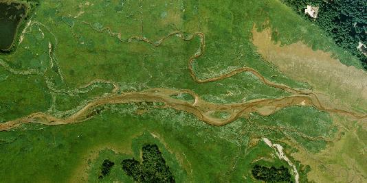
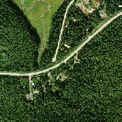
1 Executive Summary Executive Summary A North Douglas Crossing of Gastineau Channel is one of the City and Borough of Juneau (CBJ) Assembly s top transportation priorities. Project objectives are to improve transportation access and efficiency between the Juneau mainland and Douglas Island, provide a second access route for emergency response, and enhance access to the designated New Growth Area on West Douglas Island. Identifying Juneau s preferred location for the North Douglas Crossing will provide impetus and focus to move this important transportation project forward. Based on the results of earlier studies, the CBJ is now focusing on alternative crossing locations in the Vanderbilt Hill Road, Sunny Point and Yandukin Drive areas of Egan Drive, crossing to North Douglas Highway. This report provides the results of a public involvement process initiated by the CBJ to determine which crossing location is preferred by the community. Based on the results of the public process and evaluation of available technical information, it recommends that a crossing area at Vanderbilt Hill Road be identified as the community s preferred location for the North Douglas Crossing. Public Involvement Process In November 2006, the CBJ invited the Juneau public and stakeholders most affected by the crossing project to become more informed about each of the alternatives, and to share their ideas, concerns and preferences with the city. The CBJ tasked a project team led by Sheinberg Associates, with R&M Engineering, PND Engineering and McDowell Group, with the following: Facilitate and document comments about the crossing alternatives, based on existing technical information; Conduct a community opinion survey; Complete additional engineering, limited to refining the alternative alignments and updating estimated project costs; and Report to the Assembly with the results of the public involvement program and a recommendation regarding which alignment should be identified as Juneau s preferred alternative. Alternative Alignments The project team presented five conceptual alternatives for public response (Figure 1), and developed refined alignments and estimated project costs for these alternatives: Vanderbilt Hill Road to approximately 5-mile North Douglas Highway. Sunny Point (east side) to approximately 5.5-mile North Douglas Highway. Yandukin A: Yandukin Drive to approximately 6-mile North Douglas Highway. North Douglas Crossing Project Juneau s Preferred Crossing Route Page 1
2 Executive Summary Yandukin B: Yandukin Drive to the Fish Creek Road (Eaglecrest intersection), just before 7-mile North Douglas Highway, with a tunnel under the airport runway. Yandukin C: Yandukin Drive to Fish Creek Road (without tunnel). Methodology The project team met with 14 stakeholder groups; hosted two public meetings attended by 156 people, at which 34 people testified; conducted a random telephone survey of 501 Juneau households; and received 79 written comments. Stakeholder groups and individuals were asked: 1) which of the alternative crossings they prefer and why; 2) what factors they believe are most important to use in making a decision regarding a community preferred alternative; and 3) to provide any other comments regarding the crossing project. The team also met with state and federal agencies to discuss issues related to navigation, the Juneau International Airport, transportation issues, and environmental permit requirements. Results The Community Opinion Survey found that three-quarters of Juneau residents support or strongly support construction of a North Douglas crossing. Residents of Mendenhall Peninsula/Auke Bay/Glacier Highway beyond Auke Bay express strongest support, followed by Douglas/West Juneau, and North Douglas. Comments received during the public involvement program (not a random sample) were more evenly split between those who believe the crossing project to be a high priority and those who do not. In the Community Opinion Survey, crossing supporters prefer Vanderbilt Hill Road corridor over Sunny Point and Yandukin Drive alternatives. Individuals who commented during the public involvement program also prefer Vanderbilt Hill Road. The primary reasons for public support of the Vanderbilt Hill Road alternative include that it would have: 1) least impact on the Mendenhall Wetlands State Game Refuge (MWSGR), and Refuge uses and users (especially hunters); 2) least estimated construction costs; and 3) least potential for impacts to the airport s operations and future expansion needs. This rationale agrees with the survey s response that the Refuge/environment, project cost, and potential for airport impacts are the most important factors in making this decision, followed by effects on neighborhoods. There are public comments that do not support any of the alternatives identified by the CBJ. Comments suggest considering a crossing at Salmon Creek or another location that avoids a Refuge crossing. Alternatives west of the Airport are also suggested. The North Douglas Neighborhood Association and many residents urge the CBJ not to select a community preferred alternative at this time. They ask that the CBJ: 1) include construction of a Bench Road on Douglas Island into the crossing project; 2) prepare a comprehensive sub-area plan for North Douglas that would address safety, transportation, recreation, and other issues important to the quality of life of the residential area; and North Douglas Crossing Project Juneau s Preferred Crossing Route Page 2
3 Executive Summary 3) complete a North Douglas impact analysis to fully identify project impacts on the residential area. Property owners also express concern about impacts to property values and quality. Recommendations & Conclusion The project team recommends that a crossing area at Vanderbilt Hill Road be identified as Juneau s preferred alternative for the North Douglas Crossing of Gastineau Channel (Figure 2). This alignment: Has the least impact on the Refuge environment, uses and users, including areas used most intensively by hunters. Is more likely to be permitted by environmental agencies because it has the shortest crossing length and the least fill footprint on wetlands. Has lowest estimated project construction costs. Is farthest east, so has least impact on Airport. Is preferred in the Community Opinion Survey and in public comments, over a crossing at Sunny Point or Yandukin Drive. It is recommended that the preferred alternative be shown as a wider crossing area, as shown on Figure 2, as there are a number of feasible locations for the intersection within this crossing area that would meet the general characteristics for this alternative (e.g., dimensions, cost and performance.) The Vanderbilt Hill Road alternative is the closest to the existing bridge and farthest from the West Douglas New Growth Area. However, transportation analysis conducted in 2004 shows that it will improve transportation between the mainland and Douglas Island, and enhance access to West Douglas, as well as a crossing located at Sunny Point or Yandukin Drive. The Vanderbilt Hill Road corridor will intersect the North Douglas Highway farthest east of any of the alternatives. This will bisect the residential corridor and will increase traffic on the greatest length of the highway. To address concerns about effects on the North Douglas neighborhood, the project team recommends that the CBJ work with the North Douglas neighborhood to evaluate and plan for the crossing project s effect on the neighborhood, and to identify measures to maintain and enhance the area in terms of highway and pedestrian safety, recreation, and other qualities affected by the project. This could be done in the context of a comprehensive sub-area plan for the North Douglas area, during development of a later environmental decision document for the project, or through a separate effort associated with more detailed project design. The CBJ s identification of a community preferred alternative for the crossing will focus future work on the project. Many steps remain including obtaining funding for planning, analysis and construction; environmental analysis and permitting; obtaining a corridor; detailed design; and construction. There will be many opportunities for public input before final decisions are made and the project is constructed. North Douglas Crossing Project Juneau s Preferred Crossing Route Page 3
4 1.0 Introduction 1.0 Introduction For over 20 years, the City and Borough of Juneau (CBJ) has identified construction of a North Douglas crossing of the Gastineau Channel as a top transportation priority. The three primary objectives that will be served by the North Douglas Crossing are: Improve travel access and efficiency between the Juneau mainland and Douglas Island to serve existing and future transportation and other community needs. Provide a second access route and reduced travel times for emergency response. Enhance effective access to the designated New Growth Area on West Douglas Island to serve planned residential, industrial, port, commercial and recreation uses. The CBJ has long worked toward construction of the North Douglas Crossing, beginning with a 1984 CBJ-sponsored feasibility study and continuing with the city s active support of preliminary scoping, technical work and environmental analysis conducted by the Alaska Department of Transportation and Public Facilities (ADOT&PF) in When the State s work ended without completion of an Environmental Impact Statement (EIS) in 2005, the CBJ Assembly decided that Juneau should actively help to shape the project and move it forward. It is the CBJ s intent to identify Juneau s preferred location for the North Douglas Crossing, to provide impetus and needed focus to help move this important project forward. CBJ Assembly Resolution 2330(b), adopted unanimously in October 2005, reconfirmed the importance of the North Douglas Crossing to the community of Juneau (Appendix A). Based on the conclusions of the ADOT&PF scoping work ( ), the Assembly decided to focus its further consideration on three alternative crossing locations that would best meet the project s objectives (see Section 2.2 for rationale). These routes cross Gastineau Channel from the following areas on Egan Drive to intersect with North Douglas Highway (Figure 1): Vanderbilt Hill Road; Sunny Point; and Yandukin Drive. In November 2006, the CBJ initiated a public involvement program to determine which of the alternative crossing areas is preferred by the Juneau public. The CBJ invited the public and the stakeholders most affected by the crossing project to become more informed about each of the alternatives, and to share their ideas, concerns and preferences with the city. To conduct the North Douglas Crossing Public Involvement Project, the CBJ selected a project team led by Sheinberg Associates and including R&M Engineering, PND Engineering, and McDowell Group, all of Juneau. The public involvement project was North Douglas Crossing Project Juneau s Preferred Crossing Route Page 4
5 conducted from November 2006 through early-february The CBJ tasked the project team with the following: 1.0 Introduction Provide the public and the stakeholders most likely to be affected by the crossing with clear, concise information about the three crossing alternatives identified by the CBJ Assembly (Vanderbilt Hill Road, Sunny Drive, and Yandukin Drive areas), relying on existing technical information available for the project from previous studies; Facilitate public and stakeholder discussion and input about the three crossing alternatives, through interviews, public meetings, and solicitation of comments; Conduct a community opinion survey; Complete additional limited engineering to refine the alternative alignments and update estimated project costs; Report to the Assembly on the results of the public involvement program; and Make a recommendation to the Assembly regarding which alignment should be identified as Juneau s preferred alternative. This document presents the results of the tasks outlined above and presents the recommendations of the project team for Assembly consideration. North Douglas Crossing Project Juneau s Preferred Crossing Route Page 5
6 2.0 Project Background & Status 2.0 Project Background & Status The CBJ and the State of Alaska began investigating construction of a North Douglas Crossing of Gastineau Channel more than 20 years ago. CBJ land use and transportation plans consistently highlight the importance of the North Douglas crossing to meeting Juneau s current and future transportation needs and to facilitate the community s growth. The city s Areawide Transportation Plan (2001) lists the crossing as one of the top near-term priorities to improve connections between Juneau s population centers. The 1995 CBJ Comprehensive Plan indicates the need to identify the crossing corridor to move the project forward. The February 2007 draft update to the Comprehensive Plan continues to call for construction of the crossing to address congestion on the Juneau Douglas Bridge during peak traffic times and to allow for new development (including needed affordable housing) on Douglas Island, both near the existing bridge and in West Douglas. 1 Community opinion surveys show that the Juneau public consistently supports construction of the North Douglas Crossing. In 1984, 69% of those surveyed favored the crossing. 2 Polling in 2003 reported that 63% supported or strongly supported the crossing. 3 Polling in February 2007 shows that 76% of Juneau residents now support or strongly support construction of the crossing (see Section 7.0). This section briefly summarizes the findings and recommendations of the CBJ-sponsored 1984 Second Gastineau Channel Crossing Feasibility Study and the 2005 Juneau Second Channel Crossing, Project Development Summary Report prepared for the ADOT&PF. More detailed project background, maps, and evaluation of alternative crossing locations considered in these earlier studies can be found in these documents. It also discusses the October 2005 CBJ Resolution that set the framework for the city s further work on this project, and briefly describes likely next steps for progress on the project. 2.1 CBJ Feasibility Study (1984) The 1984 Second Gastineau Channel Crossing Feasibility Study (HGR, 1984) evaluated 14 alternative locations for the crossing. The alternatives spanned a nine-mile study area from Salmon Creek (farthest east) to Mendenhall Peninsula-Spuhn Island (farthest west), as well as a No Build alternative. The 1984 study included public and stakeholder consultation; and evaluation of population growth, land use, environmental conditions, traffic projections, existing and planned transportation facilities, engineering feasibility, funding, regulatory requirements, and policy constraints. The study ranked the alternatives relative to five factors: land use, environmental issues, transportation, engineering and public policy Draft CBJ Comprehensive Plan, February 20, 2007 Draft for Citizen Review and Comment. 2 Second Gastineau Channel Crossing Feasibility Study, Juneau Second Channel Crossing Household Survey Results, McDowell Group, December North Douglas Crossing Project Juneau s Preferred Crossing Route Page 6
7 2.0 Project Background & Status It recommended the development of a crossing from eight-mile Egan Drive (near the airport) to intersect with the Fish Creek (Eaglecrest) Road on Douglas Island. 2.2 ADOT&PF Preliminary Scoping and Environmental Analysis (2005) In , the State of Alaska ADOT&PF initiated a scoping process and environmental and engineering studies and analysis for a North Douglas Crossing EIS. In May 2005, ADOT&PF concluded the project without completing the EIS and published the Juneau Second Channel Crossing Project Development Summary Report (HDR Alaska, Inc., 2005). The Summary Report presented results of preliminary scoping consultations with the public and agencies, a summary of engineering and environmental baseline studies, estimated project costs, and preliminary findings and recommendations regarding the project. The Summary Report is not a complete scoping report or Draft EIS, but will be used by ADOT&PF to contribute to further EIS activities. The Summary Report considered the same 14 alternative crossing locations studied in 1984, and a No Build alternative. The report considered updated and comprehensive evaluations of physical and biological baseline conditions, transportation planning, existing and future land uses, environmental constraints and regulations, engineering criteria/constraints/feasibility, navigational considerations, land use development plans, approximate ranges of construction costs, consistency with purpose and need objectives, and agency and public comments received during the preliminary scoping phase. The 2005 Summary Report reached the following preliminary conclusions, which have informed the CBJ s recent work on the crossing project: A crossing in the vicinity of the Vanderbilt Hill Road Area to Yandukin Drive area provides the greatest potential for meeting the comprehensive project s objectives (listed in Section 1.0). The least costly crossing potentials (with embankment) are in the Vanderbilt Hill Road area to Sunny Drive area. For an all-structure crossing (bridge) of the Gastineau Channel, a Salmon Creek area crossing represents the least costly option. The Salmon Creek area and Mendenhall Peninsula area provide the only opportunities to avoid a crossing within the MWSGR. Of alternative crossing routes within the Refuge, crossings in the Vanderbilt Hill Road area to Yandukin Drive area best avoid the highest value environmental areas within the Refuge (which are located west of the airport). The Summary Report recommended against further consideration of crossing routes west of the Juneau International Airport (JIA), for the following reasons: Primary features west of the JIA include the Mendenhall River, western end of the MWSGR, Mendenhall Peninsula, Fritz Cove, and North Douglas Island in the vicinity of Fish Creek. The reasons for eliminating North Douglas Crossing Project Juneau s Preferred Crossing Route Page 7
8 2.0 Project Background & Status further consideration of this area are based on a comprehensive set of factors, including environmental hot spot areas [at Fritz Cove, the mouth of the Mendenhall River and Fish Creek] and potential impacts to protected [fish and wildlife] species; comments from regulatory agencies; results of preliminary travel demand analysis; geometric constraints with crossing the Mendenhall River in the vicinity of Industrial Boulevard and potential conflicts with JIA Part 77 airspace; 4 potential conflicts with future expansion plans at JIA; potential Section 4(f) resources on the Mendenhall Peninsula and North Douglas Island; 5 and crossing types/costs. The Summary Report also found that a crossing at Salmon Creek would not meet one of the primary need objectives of the project for locating the crossing to efficiently serve the CBJ planned New Growth Areas on North and West Douglas Island. Traffic modeling and transportation planning completed in 2004 concluded that a crossing at Salmon Creek would foster future land use development and concentrate traffic along North Douglas Highway between the existing bridge and the new crossing, and would not effectively meet the transportation demands of new development at West Douglas. 2.3 CBJ Resolution Focus on Three Alternative Routes (2005) Based on the technical work and preliminary conclusions of the Project Development Summary Report (listed above), the CBJ Assembly unanimously adopted Resolution 2330(b) in October 2005, focusing the city s consideration on three general crossing locations that would best meet project objectives: Vanderbilt Hill Road area; Sunny Point area; and Yandukin Drive area. In addition, the CBJ Resolution supported a bench road on North Douglas as a necessary transportation improvement in the future to reduce traffic on North Douglas Highway and enhance access to West Douglas. However, the Resolution specifically did not link progress on a future Bench Road with progress on the North Douglas Crossing project. 2.4 Next Steps The CBJ s identification of a community preferred alternative for the North Douglas Crossing will give focus and impetus to future work on the project. However, many steps remain to make the project a reality. Many state and federal agencies and the public will have a role in the final determination of the crossing s location and design. In simplest terms, next steps include: 4 The height of objects in the vicinity of the airport is controlled by Federal Aviation Regulations (FAR) Part 77 (Objects Affecting Navigable Airspace). 5 Refers to Section 4(f) of the U.S. Department of Transportation Act of 1966 (see Sections 4.3 and ) North Douglas Crossing Project Juneau s Preferred Crossing Route Page 8
9 2.0 Project Background & Status Obtaining state and federal support and funding for project planning, permitting, design and construction; Environmental analysis under the National Environmental Policy Act (NEPA), a State of Alaska best interest finding, and/or other decision document; Permitting; Obtaining the corridor right of way; Detailed design; and Construction. Juneau s community preferred alternative would likely be identified as the Proposed Action or preferred alternative in a NEPA document or state decision document. Identifying the alternative would not eliminate other alternatives from consideration during environmental analysis, but may serve to focus the analysis on a smaller number of alternatives. The public will have further opportunities to have input on the project during future environmental analysis and permitting. Agencies with a significant role in the project would likely include the Federal Highway Administration (if federal highway funding is used), U.S. Army Corps of Engineers in consultation with state and federal environmental agencies (for Section 404 permit to place fill in wetlands and other waters of the United States), U.S. Coast Guard (for bridge over a navigable waterway), Alaska Department of Fish and Game (for route through the MWSGR and crossing of anadromous fish streams), Alaska Department of Natural Resources (for route across state tide and submerged lands), and the Federal Aviation Administration (review for potential impacts to Airport operations. North Douglas Crossing Project Juneau s Preferred Crossing Route Page 9
10 3.0 Methodology 3.0 Methodology This section briefly describes the tasks involved in the North Douglas Crossing Public Involvement Project. Additional details about methodology are reported along with project results, in Sections Stakeholder & Agency Interviews From November 2006 to January 2007, the project team conducted interviews with 14 stakeholder groups, representing those most involved in and affected by the project. Stakeholder groups included: 6 Capital City Fire and Rescue Douglas Service Area Advisory Board Eaglecrest Ski Area Goldbelt, Inc. Juneau Airport Board Juneau Audubon Society Juneau Economic Development Council Juneau Police Department Mendenhall Refuge Citizens Advisory Group North Douglas Neighborhood Association Sunny Point Neighborhood Association Territorial Sportsmen & Ducks Unlimited Totem Creek, Inc. West Douglas Development Working Group On November 9, 2006, the project team met with representatives of local, State of Alaska and federal regulatory and resource management agencies to discuss the North Douglas Crossing Project. Primary topics of conversation included the airport, navigation, transportation, and environmental and permitting issues, and background and technical information related to the crossing project. 3.2 Public Meetings and Project Information The CBJ hosted two public meetings, on January 17, 2007, at Centennial Hall in downtown Juneau and on January 30, 2007, at St. Paul s Catholic Church Parish Hall in the Mendenhall Valley. The purpose of the meetings was to present background and technical information about the project and to solicit and document public comments. A total of 156 people attended and 34 gave verbal testimony at one or both of the meetings. The public meetings were advertised via flyers mailed to nearly 1,400 Juneau households within the project area; newspaper display notices; on the CBJ s project web site and 6 The Douglas Indian Association was contacted for a stakeholder interview, but chose to submit written comments. North Douglas Crossing Project Juneau s Preferred Crossing Route Page 10
11 3.0 Methodology meeting calendars; via KINY s Capital Chat radio interview program; and radio and cable television public service announcements. The CBJ established and maintained a web site with project background and technical documents; information about the public involvement project; project graphics, maps and photos; presentation materials from the public meetings; and an on-line public comment form that asked for responses regarding the public s preferred alternative and the factors they felt were most important in making the decision. It is expected that the web site will continue to serve as a source of information about the crossing project in the future. Copies of relevant project documents were also placed in Juneau s public libraries. The public was invited to comment on the project by February 9, 2007, through testimony at public meetings; s, letters or written comment forms submitted to the project team; and on-line comment form. Comments are summarized in Section Community Opinion Survey The project included a statistically reliable telephone survey of Juneau residents to determine their level of support for a North Douglas crossing and their preferred location. The survey also captured reasons why residents supported specific crossing locations, as well as reasons that residents opposed the project. Results of the Community Opinion Survey are reported in Section Project Engineering The project scope included limited engineering work, including refinement of alignments for the alternative crossing locations, updated project cost estimates for each alternative crossing route and structure options (road embankment vs. structural-support, fixed vs. movable span bridge). 3.5 Report and Recommendations to CBJ Assembly The project concludes with a report to the CBJ Assembly, presenting the results of the public involvement program and project team recommendations regarding which alternative should be identified as the community s preferred alternative for the North Douglas crossing project, and other issues. North Douglas Crossing Project Juneau s Preferred Crossing Route Page 11
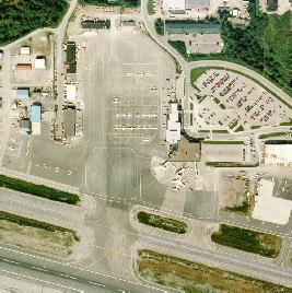
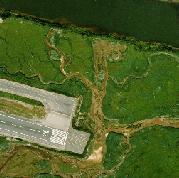
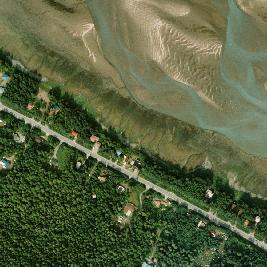
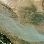
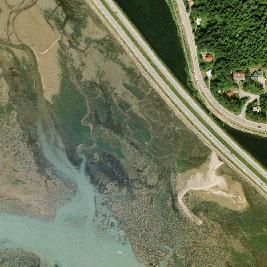
12 4.0 Context for the Crossing Project 4.0 Context for the Crossing Project This section provides background information about key features of the North Douglas Crossing project area, and opportunities and constraints. This information is important to understanding the comments, analysis and recommendations presented in later sections. 4.1 Navigability of Gastineau Channel Gastineau Channel is a navigable water body that separates mainland Juneau from Douglas Island. In 1945, federal law designated a navigable channel from Juneau to Fritz Cove, approximately 5.5 miles long and 75 feet wide with a depth of 0.0 feet mean lower low water. 7 To maintain navigability, the U.S. Coast Guard will require the new crossing to meet the same navigational clearances as the Juneau Douglas Bridge, a minimum 51-foot clearance above mean high tide. This navigability requirement adds substantially to the structure s size, height, embankment footprint, visual impact and cost. This study considers the options of a fixed span bridge or a movable span (either hinged or swing bridge) that would open to let vessels pass. If a movable span was built, the Coast Guard would determine the method and schedule for its operation, in consultation with the public. Gastineau Channel s navigability is currently restricted to high-tide passage over the Mendenhall Bar. Sediment deposition and rapid isostatic rebound continually reduce the channel s depth. If the channel were to be dredged to deepen the navigable channel, borrow embankment material from the dredging would be available for construction of the crossing. 4.2 Juneau International Airport The Juneau International Airport is located nine miles northwest of downtown Juneau, west of the Yandukin Drive area. The North Douglas Crossing project must not conflict with federal requirements to maintain unobstructed land and airspace around the runway and threshold, and must consider the potential for future expansion needs at the airport. The JIA plans to extend the current Runway Safety Area, Object Free Area and Obstacle Free Zone further to the east, to meet Federal Aviation Administration (FAA) requirements. The airport is also planning to install tower-supported runway indicator lights that will extend further east. The height of objects in the vicinity of the airport is controlled by Federal Aviation Regulations (FAR) Part 77 (Objects Affecting Navigable Airspace), to ensure the safety and efficiency of airport operations and preserve future options for operations. The locations of the controlled surface and airspace will change with future changes in airport layout and facilities. 7 Rivers and Harbors Act, March 2, 1945, House Doc. 325, 77 th Congress, 1 st Session. North Douglas Crossing Project Juneau s Preferred Crossing Route Page 12
13 4.0 Context for the Crossing Project All North Douglas Crossing alternatives considered in this study are outside of the areas restricted through these surface area and airspace controls. During the agency consultation meeting and the stakeholder interview with the JIA, the Airport Board and manager, FAA and Alaska Airlines recommended that the crossing be constructed with as low a profile and as far away from airport approaches as possible, to avoid conflicts with current and future Airport operations, safety requirements, and future space needs. 4.3 Mendenhall Wetlands State Game Refuge Each of the three alternative crossing areas identified by the CBJ cross the Mendenhall Wetlands State Game Refuge. The Refuge is approximately 3,800 acres and extends about nine miles along Gastineau Channel, from Salmon Creek to the eastern side of the Mendenhall Peninsula. The Alaska Legislature established the Refuge in 1976 (AS ) to protect natural habitat and wildlife populations, especially waterfowl, and to provide recreational opportunities. Uses include waterfowl hunting, hiking, wildlife viewing and photography, boating, fishing, scientific and educational studies, sightseeing, and other forms of recreation. The Alaska Department of Fish and Game (ADFG) manages the Refuge habitat, fish and wildlife, and human uses. The Alaska Department of Natural Resources (DNR) manages the surface and subsurface estate. The Mendenhall Refuge Citizens Advisory Group provides advice on issues related to Refuge management. The state law that established the Refuge anticipated the need for a future transportation corridor to cross through it. AS (i)) specifies that the City and Borough of Juneau may acquire land, by sale, exchange or otherwise, for purposes of establishing additional transportation corridors in the Refuge, but did not specify a location for the transportation corridor. The Mendenhall Wetlands State Game Refuge Management Plan (ADFG, 1990) requires that impacts to the Refuge be avoided, minimized and/or mitigated. The plan states: The City and Borough of Juneau may acquire land for a public transportation corridor only after the following have been demonstrated: 1) that there is a significant public need for the corridor which cannot reasonably be met offrefuge; 2) that the use of the refuge lands are avoided or minimized to the maximum extent feasible, 3) that public access to the refuge is maintained; and 4) that all unavoidable impacts to the refuge and to refuge resources are fully mitigated through restoration, replacement and/or compensation. Federal transportation law includes a similar requirement, which would apply to the project if federal highway funding were used. Section 4(f) of the Department of Transportation Act (1966) states that the Federal Highway Administration (FHWA) may approve a transportation corridor within the MWSGR only if there is no prudent and feasible alternative to the use of that land; and all possible planning is done to minimize impacts. In April 2004, the FHWA stated that Section 4(f) would apply to the North Douglas Crossing project, regardless of state law s recognition that a transportation North Douglas Crossing Project Juneau s Preferred Crossing Route Page 13
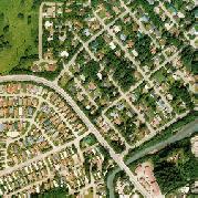
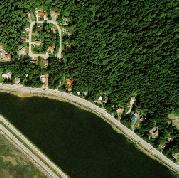
14 4.0 Context for the Crossing Project corridor crossing the Refuge would eventually be needed. Section 4(f) would also apply to city-owned park land on Douglas Island. 4.4 North Douglas Highway and Residential Area The North Douglas Crossing will cross from Egan Drive to a new intersection on the North Douglas Highway, a two-lane, paved state highway. The North Douglas Highway serves the low-density residential area that extends on both sides of the road, and provides access to areas used by the entire community for recreation and tourism, including the Eaglecrest ski area, the North Douglas boat ramp, and area beaches, trails and scenic areas. There is no sidewalk, separated pedestrian pathway, bicycle lane or pullouts on the highway. CBJ population estimates for 2006 show 1,687 people live in the linear neighborhood that extends from the Juneau Douglas Bridge to the road s end. 8 In addition to providing for vehicle transit, the highway shoulder is used for walking, biking, running, scenic enjoyment and other recreation. Many North Douglas residents and the North Douglas Neighborhood Association are concerned about increased traffic and other changes associated with construction of the North Douglas crossing and future development on Douglas Island; their comments are presented in Section West Douglas New Growth Area A key objective of the crossing project is to enhance access to the West Douglas Island New Growth Area, located on northwest Douglas Island. The CBJ has consistently planned that much of Juneau s future growth will occur at West Douglas. The New Growth Area was designated in the Comprehensive Plan of the City and Borough of Juneau (CBJ, 1995), to serve residential, industrial, port, commercial and recreation uses. The February 2007 draft update to the Comprehensive Plan retains the New Growth Area designation, stating that Douglas Island has the most buildable land in the Borough. 9 On February 12, 2007, the CBJ Assembly unanimously adopted Chapter 6 of the West Douglas Conceptual Plan (CBJ & Goldbelt, 1997) into the city s Comprehensive Plan. The conceptual plan identifies five compact development areas, including total acres over 8.5 miles of coastline. The areas would feature mixed land uses at urban/suburban densities, including up to 2,000 new residential units (low, medium and high densities), commercial, industrial and recreational uses, and open space. The CBJ must approve a Master Plan for the New Growth Area before any significant development can occur. Initial steps that have been taken toward development of the area include extension of an electrical power intertie to far North Douglas (to serve Greens Creek on Admiralty Island), and issuance of a CBJ land lease to Totem Creek for construction of a golf course and associated housing. The CBJ, area landowners and prospective area developers consider construction of the North Douglas Crossing to be essential to facilitating future development of the New Growth Area. 8 CBJ Community Development Department, 2006 CBJ Population Estimates. 9 February 20, 2007, Draft CBJ Comprehensive Plan, p. 59. North Douglas Crossing Project Juneau s Preferred Crossing Route Page 14
15 4.0 Context for the Crossing Project The City has considered construction of a road on a natural bench above the North Douglas Highway. Such a by-pass road would route West Douglas traffic off of the North Douglas Highway and away from the residential corridor. In October 2005, the CBJ Assembly reaffirmed its support for the bench road as a necessary transportation improvement in the future, to address long-term traffic needs associated with West Douglas. However, the CBJ is not linking the bench road with the North Douglas Crossing project, due to the high cost involved in pursuing these two major transportation projects concurrently. 4.6 Traffic Modeling and Transportation Planning As part of ADOT&PF s studies of the North Douglas Crossing, a transportation analysis was conducted that compared the relative performance of different crossing locations in meeting the project s transportation objectives. 10 The analysis modeled future traffic volumes and patterns for the year 2035 (comparing them to 2002) for five scenarios, including a No Build scenario and a crossing built in one of four general areas: Crossing Area A vicinity of Salmon Creek/Channel Drive; Crossing Area B area including Vanderbilt Hill Road and Sunny Drive; Crossing Area C vicinity of Yandukin Drive east of the Airport; and Crossing Area D vicinity of the Mendenhall Peninsula west of the Airport. The traffic modeling and analysis was intended to give a relative comparison of how each of the four crossing areas and the No Build scenario would function under different growth scenarios, but not an exact prediction of traffic volumes, travel routes or patterns in Another objective of the analysis was to determine if where the crossing was located would affect the number of travel lanes required on the bridge and connecting roadways. Relative traffic volumes and travel patterns expected in 2035 were modeled for each of the five crossing scenarios. The traffic model considered the number of vehicle trips, where vehicles would be traveling to and from, and what route they would take between mainland Juneau and Douglas Island. The model was run for three different population and employment growth rates for Juneau between 2002 and 2035 (low=0.5% growth, medium=1.0%, high=1.5%). 11 It also input planners projections for where Juneau s future population and jobs would be geographically distributed under each of the five crossing scenarios HDR Alaska, Inc., Transportation Planning Technical Memorandum, February CBJ population trends show average annual growth rates of 3.3% from ; 1.4% per year from ; and 0.7% per year from (Sources: Census Bureau and Department of Labor and Workforce Development). 12 An expert panel with local knowledge of community and transportation planning and land management developed projections for distribution of population and employment for 2035 under the five crossing scenarios. They based projections on the availability of private and CBJ land for development, and the relative attractiveness of land and cost of development. North Douglas Crossing Project Juneau s Preferred Crossing Route Page 15
16 4.0 Context for the Crossing Project Projecting ahead to 2035, the transportation analysis found that a crossing in either the Vanderbilt Hill Road or Sunny Point areas (Crossing Area B) or the Yandukin Drive area (Crossing Area C) would work equally as well to: Relieve traffic on the existing Juneau Douglas bridge; Reduce traffic on North Douglas Highway between the existing bridge and the new crossing; Increase traffic on North Douglas Highway west of the new crossing (as West Douglas Island develops); and Provide effective access to north and west Douglas Island and stimulate and serve planned development of these areas. A crossing at Vanderbilt Hill or Sunny Point (Area B) would result in shorter travel times from North Douglas to Lemon Creek and downtown Juneau. A Yandukin Drive crossing (Area C) would result in shorter travel times from North Douglas to the airport, Mendenhall Valley and areas north. The analysis was instrumental to the 2005 Summary Report s conclusion that a crossing at Salmon Creek (Crossing Area A) or west of the Airport (Crossing Area D) would not effectively meet the project s objectives. It found that a crossing at Salmon Creek would foster future land development and growth on North Douglas Highway between the existing bridge and the new crossing (closer to downtown Juneau), and would substantially increase traffic on that section of the highway compared to a No Build option. It would not as effectively carry vehicles to future development on far north and west Douglas Island. The model showed that a crossing west of the Airport would attract the least vehicle use of the four crossing areas, due to the length of the routes. Traffic volume on the existing bridge would increase compared to a No Build option. The analysis found that the No Build scenario would result in little additional land use development on Douglas Island, due to capacity limitations of the current bridge and adjacent intersections, and in increased traffic on the existing bridge. The traffic model also determined that the location of the crossing would not affect the sizing of the bridge and connecting roadways. It found that two-lane crossing structure and connecting roadways would be sufficient to carry projected traffic volumes. North Douglas Crossing Project Juneau s Preferred Crossing Route Page 16
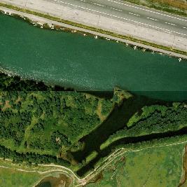
17 5.0 Description of Alternatives 5.0 North Douglas Crossing Alternatives Five alternative conceptual alignments were presented to the public for comment during the North Douglas Crossing Public Involvement Project. These five alternatives are shown on Figure 1, and include: Vanderbilt Hill Road to approximately 5-mile North Douglas Highway. Sunny Point (east side) to approximately 5.5-mile North Douglas Highway. Yandukin A: Yandukin Drive to approximately 6-mile North Douglas Highway. Yandukin B: Yandukin Drive to the Fish Creek Road (Eaglecrest intersection) at nearly 7-mile North Douglas Highway, with a tunnel under the airport runway. Yandukin C: Yandukin Drive to Fish Creek Road (without tunnel). At each location, the crossing could be constructed either as a fill embankment or structure-supported roadway, with either a fixed span bridge or a movable span bridge. This section describes methods used to refine the alternative crossing alignments and provide updated project cost estimates. It also describes each conceptual alignment, including its general route, length, fill footprint, and estimated construction costs. 5.1 Engineering Tasks and Methodology R&M Engineering used existing base mapping information and alignments from prior work done for ADOT&PF to develop the five alternative conceptual alignments. R&M relocated the Sunny Point corridor to connect to the separated grade interchange on Egan Drive to be constructed in The Yandukin corridors were relocated to align with the proposed location of a separated grade interchange on Egan Drive west of Fred Meyers, and to avoid planned safety area extensions and potential conflicts with future air space requirements east of the airport. All alignments were refined to shorten the total length and the length in the MWSGR, shorten the bridge length, and reduce the fill footprint. R&M prepared plan and profile drawings for each alignment for use in project cost estimation. For Egan Drive intersections, ADOT&PF has indicated that the crossing should connect to a grade-separated intersection to assure capacity and safety. This is consistent with the existing ADOT&PF Value Engineering Study (ADOT&PF, 2002) that recommends grade-separated intersections at Vanderbilt, Sunny Point and Yandukin. Conceptual feasible intersection locations were identified on North Douglas Highway based on land ownership, undeveloped property, and to ensure feasible access to a potential future Bench Road. R&M Engineering confirmed that all potential intersection North Douglas Crossing Project Juneau s Preferred Crossing Route Page 17
18 5.0 Description of Alternatives locations would comply with ADOT&PF s sight-distance requirements. 13 R&M also prepared a conceptual design for an at-grade, three-way intersection typical of that which would be constructed North Douglas Highway (Appendix B). The intersection improvements to North Douglas Highway would fit within the existing typical 100-foot right of way corridor. The improvements related to the crossing as it comes into the highway could fit within an average single lot width. 14 PND Engineering evaluated options for fixed bridge spans and for structure-supported roadways, considering concrete deck assemblies supported on piers and/or piles. After examination of various movable bridge types, PND judged that only a swing or hinged span bridge designs would be feasible for this crossing. Tube tunnel options were considered for the segment of roadway under the runway at JIA for the Yandukin B option only. Sectionalized concrete segments using cut and cover installation methods were considered the most feasible tunneling options for the Yandukin B route. This proven method anticipates deep trench excavations for placement of the concrete tube sections on a prepared foundation base followed by backfilling. Approach structures in and out of the tunnel are required to satisfy vertical grade profiles beyond the runway limits. Estimated project costs were determined for each of the five alternative crossing alignments, for four configurations: 1) fill embankment with a fixed span bridge, 2) fill embankment with a movable bridge, 3) structure-supported roadway with fixed bridge, and 4) structure-supported roadway with movable bridge. Costs were presented as a range; the lowest costs assumed use of borrow material from channel dredging and a lower construction contingency (5%), the high end assumed purchase of borrow and a higher contingency (15%). 15 Detailed cost estimates are provided in Appendix C. 13 ADOT&PF Alaska Preconstruction Manual (2005) requires a minimum sight distance of 360 feet for the posted speed limit of 45 miles per hour. 14 Mechanical stabilized retaining walls up to 50-ft. may be required on the lower portions of the embankment to keep the fill contained on a single lot. The Vanderbilt crossing and the Yandukin crossings to Fish Creek Road (Yandukin B and C) would require these higher walls. 15 For the roadway portions of the crossings, R&M referenced bid prices for recent ADOT&PF and CBJ projects. For fixed span bridge costs, PND referenced historical bid costs in Alaska. For movable spans, PND referenced construction costs from bridges in other states (Washington, Florida), since no costs could be found for similar work in Alaska. Tunnel costs were assessed based on PND s recent work for ADOT&PF for Gravina Island Access in Ketchikan. R&M also estimated project costs for a crossing from Vanderbilt Hill Road to the CBJ-owned Five Mile Access point on North Douglas Highway, slightly east of the Vanderbilt Hill Corridor on Figure 1 (calling this Vanderbilt B ). Costs were slightly lower due to the shorter crossing length. North Douglas Crossing Project Juneau s Preferred Crossing Route Page 18
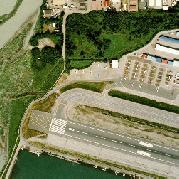
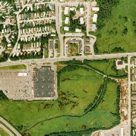
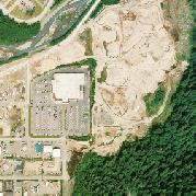
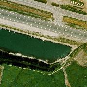
19 5.0 Description of Alternatives 5.2 Alternative Alignments Vanderbilt Hill Road Corridor The Vanderbilt Hill Road corridor would cross Gastineau Channel from the existing intersection location at Egan Drive, to approximately 5-mile on North Douglas Highway, east of Hendrickson Creek. The crossing would be approximately 4,200 feet and would be aligned to take a direct route across the MWSGR to Douglas Island. Figure 1 shows a conceptual location for the intersection with North Douglas Highway (on private land). However, there are a number of feasible locations for the intersection, including two adjacent city-owned lots at 5-mile North Douglas Highway classified as natural area park. The Vanderbilt Hill Road corridor would cross primarily unvegetated tidelands and submerged lands in the Refuge. The approximate fill footprint would range from 0.5 acres for a structure-supported road with either a fixed or movable bridge, to 8.3 acres for an embankment roadway with a fixed span bridge, and 11.0 acres for an embankment roadway with a movable bridge. Estimated project costs for the Vanderbilt Hill Road corridor: Embankment with fixed span bridge: $52 - $64 million Embankment with movable span bridge: $65 - $81 million Structure-supported road with fixed span bridge: $105 - $118 million Structure-supported road with movable span bridge: $131 - $148 million The Vanderbilt Hill Road intersection at Egan Drive is planned for eventual upgrade to a grade-separated intersection. ADOT&PF has indicated that the intersection should be upgraded prior to or in conjunction with construction of a crossing. A new interchange would cost an estimated $40 million Sunny Point Corridor The Sunny Point corridor would cross east of Sunny Point, from the location of the new grade-separated intersection to be constructed on Egan Drive in , to approximately 5.5-mile on North Douglas Highway, west of Hendrickson Creek. The crossing would be approximately 7,200 feet and would be aligned to take a direct route across the MWSGR to Hendrickson Point on Douglas Island. Figure 1 shows the conceptual alignment crossing Hendrickson Point through privatelyowned undeveloped land and intersecting North Douglas Highway at a specific location (also private land). However, there are a number of feasible locations for the North Douglas intersection (including on CBJ-owned land). West of the conceptual alignment shown on Figure 1, is an undeveloped 108-acre parcel of CBJ-owned land on North Douglas Crossing Project Juneau s Preferred Crossing Route Page 19
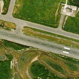
20 5.0 Description of Alternatives Hendrickson Point classified as a natural area park; an undeveloped city-owned lot connects this large parcel to the highway. The Sunny Point corridor would cross primarily low estuarine marsh wetlands in the MWSGR and would cross bog/fen wetlands on Hendrickson Point. The approximate fill footprint would range from 3.9 to 4.4 acres for a structure-supported road, to 14.9 acres for an embankment roadway with a fixed span bridge, and 18.5 acres for an embankment roadway with a movable span bridge. Estimated project costs for the Sunny Point corridor: Embankment with fixed span bridge: $62 - $77 million Embankment with movable span bridge: $75 - $94 million Structure-supported road with fixed span bridge: $137 - $155 million Structure-supported road with movable span bridge: $164 - $185 million The Sunny Point grade-separated interchange on Egan Drive is under contract for construction, to be completed in It is estimated that $5 million would be needed to upgrade the interchange to accommodate additional traffic and turning movements for a North Douglas Crossing Yandukin A Corridor The Yandukin A corridor would cross from the location of a planned grade-separated interchange on Egan Drive in the Yandukin Drive area (west of Fred Meyers), to approximately 6-mile on North Douglas Highway, east of Johnson Creek. The crossing would be approximately 7,650 feet. It would be routed east of the airport runway (meeting surface and airspace clearance requirements), and then cross the MWSGR to Hendrickson Point on Douglas Island. Figure 1 shows the Yandukin A corridor intersecting Douglas Island at the western edge of a 108-acre city owned natural area park on Hendrickson Point, and intersecting North Douglas Highway in the vicinity of an undeveloped city-owned lot that connects this large parcel to the highway. However, there are a number of feasible locations for the intersection that would meet the general characteristics for this alternative, described below. The Yandukin A corridor would cross primarily high estuarine marsh wetlands in the MWSGR and bog/fen wetlands on Hendrickson Point. The approximate fill footprint would range from 1.8 acres for a structure-supported road with either a fixed span or movable span bridge, to 15.8 acres for an embankment roadway with a fixed bridge span, and 18.4 acres for an embankment roadway with a movable bridge span. North Douglas Crossing Project Juneau s Preferred Crossing Route Page 20


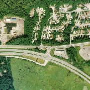


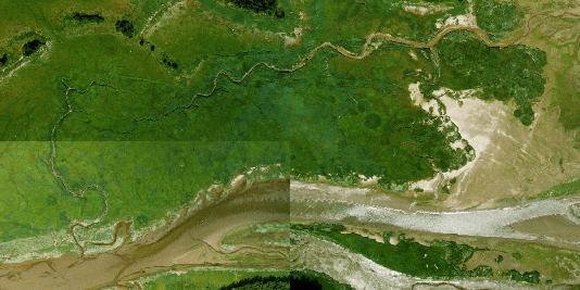

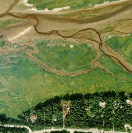


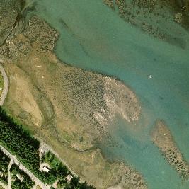
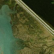


21 6 MILE I:\2006\061355\Eagle Point\061355wk_web&pwrpt_color.dwg PLOT: March 20, 2007 at: 8:12am R&M Engineering 5 MILE AERIAL PHOTOS: FLOWN BY R&M ENGINEERING, INC., 2001 ORTHORECTIFIED BY CBJ LIDAR MAPPING DONE FOR CBJ FIGURE 1 CONCEPTUAL ALIGNMENTS FOR JUNEAU NORTH DOUGLAS CROSSING ALTERNATIVES R&M PROJECT No NOTES: 1. Conceptual alignments shown in 500-foot wide corridors. Actual right-of-way would be about 250 feet wide. 2. Potential connections to proposed Bench Road route would not be constructed as part of this project. JANUARY 16, 2007
22 5.0 Description of Alternatives Estimated project costs for Yandukin A corridor: Embankment with fixed span bridge: $68 - $85 million Embankment with movable span bridge: $76 - $94 million Structure-supported road with fixed span bridge: $171 - $192 million Structure-supported road with movable span bridge: $197 - $222 million The Yandukin Drive intersection at Egan Drive is planned for eventual upgrade to a grade-separated intersection. ADOT&PF has indicated that the intersection should be upgraded prior to or in conjunction with construction of a crossing. A new interchange is estimated to cost $47 million Yandukin B Corridor The Yandukin B corridor would cross from the location of a planned grade-separated interchange on Egan Drive in the Yandukin Drive area (west of Fred Meyers), to the Fish Creek Road (Eaglecrest) intersection on Douglas Island. The crossing would intersect North Douglas Highway through a state-owned right of way lot. The Yandukin B corridor would be approximately 7,000 feet total, including a 1,000-foot tunnel under the airport runway. The tube tunnel would accommodate two vehicle travel lanes and a separate pedestrian/bicycle lane, and would be lit and ventilated. The surface road would cross primarily high estuarine marsh wetlands in the MWSGR and forested wetlands on Douglas Island. The approximate fill footprint would range from 1.0 acre for a structure-supported road with either a fixed span or movable span bridge, to 8.1 acres for an embankment roadway with a fixed span bridge, and 13.7 acres for an embankment roadway with a movable span bridge. Estimated project costs for Yandukin B corridor: Tunnel and embankment with fixed span bridge: $177 - $201 million Tunnel and embankment with movable span bridge: $173 - $201 million Tunnel and structure-supported road with fixed span bridge: $204 - $231 million Tunnel and structure-supported road with movable span bridge: $226 - $255 million The Yandukin Drive intersection at Egan Drive is planned for eventual upgrade to a grade-separated intersection. ADOT&PF has indicated that the intersection should be upgraded prior to or in conjunction with construction of a crossing. A new interchange is estimated to cost $47 million. North Douglas Crossing Project Juneau s Preferred Crossing Route Page 22
23 5.0 Description of Alternatives Yandukin C Corridor The Yandukin C corridor would cross from the location of a planned grade-separated interchange on Egan Drive in the Yandukin Drive area (west of Fred Meyers), to the Fish Creek Road (Eaglecrest) intersection on Douglas Island. The crossing would be approximately 9,750 feet. It would be routed east of the airport runway (meeting surface and airspace clearance requirements), and then turn westward, cross Gastineau Channel and intersect North Douglas Highway at Fish Creek Road. The Yandukin C corridor would cross primarily high estuarine marsh wetlands in the MWSGR and forested wetlands on Douglas Island. The approximate fill footprint would range from 1.0 acres for a structure-supported road with either a fixed span or movable span bridge, to 20.1 acres for an embankment roadway with a fixed span bridge, and 23.5 acres for an embankment roadway with a movable span bridge. Estimated project costs for Yandukin C corridor: Embankment with fixed span bridge: $87 - $108 million Embankment with movable span bridge: $96 - $120 million Structure-supported road with fixed span bridge: $217 - $245 million Structure-supported road with movable span bridge: $252 - $284 million The Yandukin Drive intersection at Egan Drive is planned for eventual upgrade to a grade-separated intersection. ADOT&PF has indicated that the intersection should be upgraded prior to or in conjunction with construction of a crossing. It is estimated that $47 million would be required to construct the new interchange. North Douglas Crossing Project Juneau s Preferred Crossing Route Page 23
24 6.0 Summary of Public Comments 6.0 Public Involvement & Agency Consultation During the North Douglas Crossing Public Involvement Project, the project team spoke with 14 stakeholder groups and received 79 written comments (letter, or on-line form) and a copy of a petition from the Build the Bridge Committee. Thirty-four people testified during the two public meetings held in January The project team also met with local, state and federal agencies. This section summarizes all comments received, indicates what was heard from stakeholder groups and from individual respondents, and reports input from agencies. Appendices to this report include notes from stakeholder interviews, public and agency meeting summaries, a matrix summarizing all stakeholder and public comments, and copies of all written comments. Stakeholder and public comments do not give a statistically reliable indication of Juneau s opinion on the crossing project, but offer the depth of thinking of people who took the time to become well-informed about the alternatives being considered by the CBJ, other approaches, and the advantages and disadvantages of each. They tend to be those most interested in potential effects on the community attributes or resources they value, and most vested in the outcome of the selection of a community preferred alternative. A Community Opinion Survey was also used to provide a statistically reliable poll of Juneau residents about the crossing project and alternative crossing routes. Results of the survey are presented in Section Agency Consultation On November 9, 2006, the project team met with representatives of local, State of Alaska and federal regulatory and resource management agencies to obtain background information and discuss key issues relative to the crossing project. 16 The morning session focused on airport, navigation, transportation and technical issues; the afternoon on environmental permit requirements. Agency meeting summaries are included in Appendix D. FAA and Airport staff, Airport Board members, and an Alaska Airlines representative discussed plans to improve the Runway Safety Area and approach lighting on the runway s east end and reviewed regulations requiring surface and airspace setbacks for obstruction. They urged that the alignment be routed farther east (e.g., Vanderbilt Hill 16 Agencies and others represented included Alaska Airlines, Alaska Department of Environmental Conservation, ADFG, ADOT&PF, CBJ Community Development Department, CBJ Engineering, CBJ Ports and Harbors, DNR, FAA, JIA managers and Board members, National Marine Fisheries Service, USCG, U.S. Environmental Protection Agency, and U.S. Fish and Wildlife Service. North Douglas Crossing Project Juneau s Preferred Crossing Route Page 24
25 6.0 Summary of Public Comments Road or Sunny Point) to avoid future conflicts with airport operations and expansion needs. The U.S. Coast Guard (USCG) confirmed that a new crossing would be required to meet the same navigational clearances as the existing bridge and indicated that if a movable span bridge was installed, the USCG would consult with the public and determine the method and schedule for operation. State and federal regulatory agencies discussed the environmental values of the project area and permitting requirements. Under the federal Clean Water Act (regulating placement of fill in wetlands), the Corps of Engineers must permit the least environmentally damaging practicable alternative. Permitting agencies will consider the crossing location (e.g., routing through areas with lower environmental value), design (e.g., length of crossing, size of fill footprint on wetlands), and other factors that influence the impact of the project on the environment. Agency staff emphasized that the least fill footprint in wetlands is best. Mitigation will be required for unavoidable impacts. Regarding a crossing of the MWSGR, agencies discussed the requirements of Section 4(f) and the Refuge Management Plan that require the crossing project to avoid, minimize and mitigate impacts to the Refuge (see Section 4.3). If a Refuge crossing is pursued, agencies urged that the shortest crossing be constructed, and they preferred an alignment near one end or the other of the Refuge, rather than crossing through the middle. The project must consider impacts to fish and wildlife populations and habitat, and to uses and users of the Refuge. There is concern about impacts on waterfowl hunting (including the potential for establishment of no-hunting zones). Hunting is most intensive between Lemon Creek and the airport Stakeholder and Publlc Comments Regarding Alternatives The CBJ Assembly asked the Juneau public which crossing area it prefers: Vanderbilt Hill Road, Sunny Point or Yandukin Drive (Figure 1). Forty-one stakeholder groups or individuals express a preference for one (or more) of these areas. Strictly in terms of the number of responses, there is greatest preference for the Vanderbilt Hill Road corridor (17-21 favorable responses), followed by Sunny Point (12-17 responses), and then by a crossing at Yandukin Drive corridor A, B or C (7-8 responses). Supporters comments and rationale are summarized in Sections , below. An additional nine comments express their support for the North Douglas Crossing project, but do not express a preference among the alternatives. These include the following stakeholder groups: Capital City Fire and Rescue, Douglas Indian Association, Douglas Service Area Advisory Board, Goldbelt, Inc., Juneau Economic Development Council, Juneau Police Department, Totem Creek, and West Douglas Development Working Group. Several urge the CBJ to select whichever alternative best meets project objectives, is most likely to be permitted, and is most feasible to construct. 17 ADFG letter to Sheinberg Associates, February 26, 2007 (See Appendix C). North Douglas Crossing Project Juneau s Preferred Crossing Route Page 25
26 6.0 Summary of Public Comments Twenty-seven stakeholder groups and individuals suggest a different alternative: a crossing at Salmon Creek or another non-refuge location, a crossing west of the Airport, or a No Build alternative. Their suggestions are discussed in Section 6.2.4, below. Finally, twenty comments were received stating that it is premature for the CBJ to be selecting a community preferred alternative for the crossing. The North Douglas Neighborhood Association stakeholder group made this comment, along with neighborhood residents. A summary of stakeholder interviews is provided in Appendix E. Public meeting summaries are in Appendix F, a matrix of stakeholder and public comments in Appendix H, and a copy of all written comments in Appendix I Vanderbilt Hill Road Corridor People or groups who prefer the Vanderbilt Hill Road corridor offer the following reasons (in random order): Shortest route; smallest wetland fill footprint; most likely to receive environmental permits. Of routes in Refuge, would have the least impact on fish and wildlife, habitats, uses and users, and areas used by waterfowl hunters. Lowest estimated project cost. Least airport impact. Good transportation connection to Lemon Creek commercial area. Intersection on Egan Drive is closest to Bartlett Memorial Hospital. Connects to an existing intersection on Egan (intended for upgrade). Seventeen comments favor a crossing at Vanderbilt Hill Road, and four prefer either Vanderbilt Hill or Sunny Point (including the Airport Board). People who do not prefer the Vanderbilt Hill Road crossing say that it is too close to the existing bridge; would fragment the North Douglas neighborhood and route traffic onto the greatest length of North Douglas highway; potentially require a high embankment across the wetlands with greater hydrologic and visual impacts; and may cross unstable soils in the channel Sunny Point Corridor People or groups who prefer the Sunny Point corridor offer the following reasons (in random order): Connects to Egan intersection being upgraded to a grade-separated interchange in Avoids airport area. North Douglas Crossing Project Juneau s Preferred Crossing Route Page 26
27 6.0 Summary of Public Comments Balanced location: Farther west than Vanderbilt Hill; accessible to Mendenhall Valley and Lemon Creek. Can route through CBJ property at Hendrickson Point (on Douglas Island) and give more flexibility on North Douglas Highway intersection location. Estimated project costs reasonable. Twelve comments favor a crossing at Sunny Point, four prefer either Sunny Point or Vanderbilt (including the Airport Board), and one either Sunny Point or Yandukin Drive. Those who do not support a crossing at Sunny Point say that it is longer than the Vanderbilt Hill crossing and would have a larger fill footprint and higher cost; would bisect the open expanse of the Refuge wetlands and impact higher value estuarine wetlands; and would affect areas intensively used by waterfowl hunters. They note higher fish and wildlife values at Sunny Point than at Vanderbilt Hill Road. Finally, they state that the intersection with North Douglas Highway would fragment the North Douglas neighborhood and route traffic onto a substantial length of North Douglas highway; would have visual impacts; and may cross unstable soils in the channel Yandukin Drive Corridors (A, B or C) People or groups who prefer one (or more) of the Yandukin Drive corridors offer the following reasons (in random order): Furthest west crossing; best meets objective of transportation access to farther north and west Douglas for development, recreation and emergency response. Central location for accessing North Douglas Highway and conveying sewer lines to Douglas Island. Yandukin B and Yandukin C, which intersect North Douglas Highway at Fish Creek (Eaglecrest) Road, would: 1) minimize fragmentation of North Douglas neighborhood, 2) have least traffic impacts on North Douglas residential areas, 3) offer best access to Eaglecrest. Yandukin B (tunnel under airport runway) would have less visual impact and less Refuge and wetlands impact than other Yandukin alternatives. Yandukin C would cross higher elevation wetlands, which are lower value than the low estuarine marsh at Sunny Point. Personal observation that fewer hunters, hikers, fishers may use the Yandukin C crossing area than Vanderbilt or Sunny Point areas. Seven comments favor a crossing at one of the Yandukin Drive corridors; one prefers either Yandukin Drive or Sunny Point. 18 Eaglecrest prefers the Yandukin B or C crossings, but notes that a crossing at any location would improve access to the ski area. 18 Yandukin A 2 comments in support; Yandukin B 2; Yandukin C 1; Yandukin B or C 2; any Yandukin option 1. North Douglas Crossing Project Juneau s Preferred Crossing Route Page 27
28 6.0 Summary of Public Comments Capital City Fire and Rescue expresses strong support for any crossing because of the importance of a secondary emergency access, but notes the Yandukin Drive corridors proximity to the Glacier Fire Station. Those who do not support a Yandukin Drive alternatives note the potential for impacts to airport operations and future expansion with Yandukin A or C; the long crossings that bisect the open expanse of Refuge wetlands; and potential visual impacts. They also note that the Yandukin B tunnel raises airport impact, management and security issues, and is too costly. The Airport Board specifically recommends against the Yandukin A and C corridors, which would be located immediately east of the airport runway safety Comments Suggesting Other Alternatives Salmon Creek or Non-Refuge Alternative People or groups who suggest that the CBJ consider a crossing at Salmon Creek or another non-refuge location give the following reasons (in random order): Complies with Section 4(f); avoids impacts to MWSGR, its fish and wildlife, habitats, uses and users. Shorter route than alternatives being considered by CBJ; could span with fixed span bridge, provide navigability, avoid wetlands fill. Lower estimated project cost than alternatives being considered by CBJ (based on 2005 Summary Report). No airport conflicts. Closest to hospital, for improved emergency response. Less impact on Sunny Point neighborhood than a Sunny Point crossing. Focuses future growth on Douglas Island closer to downtown Juneau, encouraging a more compact and affordable pattern for community development than developing the West Douglas New Growth Area. Thirteen comments favor a crossing at Salmon Creek, four recommend any non-refuge location, and one recommends either Salmon Creek or west of the Airport. These comments included responses from the Juneau Audubon Society, Mendenhall Refuge Citizens Advisory Group, Sunny Point Neighborhood Association, and Territorial Sportsmen/Ducks Unlimited. Comments that do not support a Salmon Creek location note that it is too close to the existing bridge, would intersect North Douglas Highway in a location that would fragment that neighborhood, and would route traffic onto a greater length of North Douglas Highway than the alternatives being considered by the CBJ. North Douglas Crossing Project Juneau s Preferred Crossing Route Page 28
29 6.0 Summary of Public Comments West of the Airport Alternatives Five comments recommend consideration of a crossing west of the airport, and one recommends either Salmon Creek or west of the Airport. They note that it would allow a connection farther west on North Douglas Highway, potentially through CBJ-owned land (e.g., at Peterson Point). They felt that a route farther west would provide the most direct connection to West Douglas; facilitate travel between north and west Douglas Island and the Mendenhall Valley, and minimize impacts on the North Douglas neighborhood. They further suggest that it would have less impact to Refuge resources, uses and users than a crossing through the broad wetland area east of the Airport No Build Alternative Four comments recommend a No Build alternative. They question the need for the crossing and feel that Juneau s future development needs can best be met within its existing road system. They feel that project costs are too high and potential impacts from a crossing too great to pursue it. 6.3 Factors Important to the Public and Stakeholders When Evaluating Alternatives When indicating which alternative they prefer, stakeholders and the public were asked to indicate the factors they think are most important to the decision of where to locate the North Douglas Crossing. The following factors are listed in order, from those most frequently mentioned in public comment to those least often mentioned: 1) Refuge & environmental impacts including impacts to wetlands, fish and wildlife, hunting, other uses 2) Impacts to neighborhoods and property owners 3) Meets transportation objectives (access, convenience) 4) Project costs 5) Airport impacts 6) Emergency response 7) Feasibility (likely to be permitted; feasible to build) 8) Facilitates sensible future community development 9) Transportation safety 10) Access to recreation 11) Visual impacts 12) Navigation North Douglas Crossing Project Juneau s Preferred Crossing Route Page 29
30 6.0 Summary of Public Comments These responses, as well as responses from the Community Opinion Survey, were considered by the project team in determining which key evaluation factors were most relevant to identifying a community preferred alternative (see Section 8.0). 6.4 Comments Regarding Key Issues Related to the North Douglas Crossing In addition to commenting on a preferred alignment for a North Douglas Crossing, many stakeholders and individuals commented on general issues related to the North Douglas Crossing project. These comments are summarized in this section View of Importance of North Douglas Crossing Twenty-five comments from stakeholder groups or individuals view the crossing as a high transportation priority for Juneau. They note that it will improve emergency response; relieve traffic on the existing bridge; and facilitate Juneau s long-term growth, including near-term opportunities to developing West Douglas for recreation, housing and tourism. They note that it will save fuel and time, and reduce emissions, and that delaying the project will increase its eventual cost. Stakeholder groups that view the project as a high priority include: Capital City Fire and Rescue, Douglas Indian Association, Douglas Service Area Advisory Board, Eaglecrest, Goldbelt, Inc., Juneau Economic Development Council, Juneau Police Department, Totem Creek, and West Douglas Development Working Group. Twenty comments question the crossing project s urgency. West Douglas development is questioned by some as unnecessary and speculative (given Juneau s recent growth rate), and not the best community planning solution to meet Juneau s needs (including affordable housing). A number of comments suggest that growth could occur in other locations (e.g., in-fill on the mainland) with lower cost and less environmental impact, and that funds should be spent on other community transportation needs. Some suggest construction of a third lane on the Juneau Douglas Bridge as a less expensive solution to existing bridge congestion. Stakeholder groups that do not view the project as a high priority include: Juneau Audubon Society, Mendenhall Refuge Citizens Advisory Group, Sunny Point Neighborhood Association, and Territorial Sportsmen/Ducks Unlimited Process for Selecting a Community Preferred Alternative Twenty-three comments express concern with the CBJ s process for selecting a community preferred alternative, stating that the process is premature. They state that the CBJ narrowed the range of alternatives too soon, without the benefit of a more complete alternatives analysis in an EIS or other decision document. Others that the process did not adequately involve affected parties (especially property owners) and did not make a specific commitment to and description of mitigation for impacts to neighborhoods and the Refuge. Several people suggest that a more deliberate, collaborative multistakeholder process be convened to build consensus about the best location and approach for the North Douglas Crossing. The following stakeholder groups share some or all of North Douglas Crossing Project Juneau s Preferred Crossing Route Page 30
31 6.0 Summary of Public Comments these concerns: Juneau Audubon Society, Mendenhall Refuge Citizens Advisory Group, North Douglas Neighborhood Association, Sunny Point Neighborhood Association, and Territorial Sportsmen/Ducks Unlimited Impacts on North Douglas Neighborhood and Property Owners The North Douglas Neighborhood Association (NDNA) and many North Douglas residents participated very actively in the public involvement process. NDNA has approximately 150 active members, has been involved in the crossing issue for over three years, participates on the West Douglas Development Working Group, and conducted a recent survey of North Douglas residents regarding the crossing project and potential construction of a Bench Road. 19 The NDNA does not oppose the crossing project, but has strong concerns with its potential impact on the neighborhood, and with the process the CBJ is using to select a community preferred alternative (see Section 6.4.2). NDNA comments state that they are guided by a strong desire to maintain and enhance their neighborhood and the quality of life that led them to live in North Douglas. They are specifically concerned with impacts to highway and pedestrian safety, recreation, wetlands, the quality of life in the neighborhood, and impacts to the value and quality of personal property. The Association and many residents have not identified a preferred alternative from the alignments being considered by the CBJ. Instead, they recommend that the following steps be taken before the Assembly decides on a community preferred alternative Inclusion of the Bench Road in the North Douglas Crossing Project The NDNA and others urge the CBJ to include the Bench Road in the North Douglas Crossing project. Comments from thirty-two individuals or stakeholder groups (including the North Douglas and Sunny Point Neighborhood Associations) support the Bench Road to route traffic associated with the crossing and the West Douglas New Growth Area off of the North Douglas Highway. Many note that their support for a crossing is linked to their support for the Bench Road. Comments express concern that without a Bench Road to carry heavy traffic loads, the neighborhood will face severe impacts to its quality of life, rural character, and safety, and property owners will be impacted by highway widening. They remind the CBJ that the 1995 CBJ Comprehensive Plan said that: a comprehensive traffic evaluation [that evaluates both the crossing and the Bench Road] should be completed before either of the two alternatives is pursued in detail, and ask that this study be done. 19 The NDNA survey found that 75% of the 135 residents who responded favored a crossing, while 60% favored a Bench Road. Support of the two projects was often linked. The highest ranked crossing route among the survey respondents was from Yandukin Drive to the Fish Creek (Eaglecrest) Road intersection. North Douglas Crossing Project Juneau s Preferred Crossing Route Page 31
32 6.0 Summary of Public Comments In contrast, four comments do not support the Bench Road. They question the need for the road and express concern that linking the two projects would delay or derail the crossing project Community Development Issues Fourteen comments request that a comprehensive neighborhood and transportation plan be prepared for North Douglas Island, before a community preferred alternative for the crossing is selected. They suggest that the plan address safety, recreation, transportation analysis, housing growth, utilities, Eaglecrest, parks, tourism growth and impacts, and other issues related to future development. This request was made by the NDNA stakeholder group and many neighborhood residents. In addition, five comments urge that the CBJ reconsider designating West Douglas as the best place for Juneau s future growth. They question locating new development this far from existing developed areas, note the high public cost for infrastructure and services, and suggest that growth be accommodated through in-fill of mainland locations. The Sunny Point Neighborhood Association stakeholder group expresses this concern Completion of a North Douglas Impact Analysis Seventeen comments request completion of an impact analysis, which would analyze the impacts of the crossing project on North Douglas. They suggest that the impact analysis address the economic, social and environmental impacts of all proposed alternatives, to maximize the mitigation of detrimental impacts such as the loss of property and homes, highway safety and reduced property values Property Values and Compensation Nineteen comments express concern about the effect of the North Douglas Crossing project on property owners, and want assurance that there will be adequate compensation for property owners who are directly impacted by the crossing or the intersection, or whose property is indirectly impacted (e.g., by noise, lights). Some comments also raise concern that depicting potential crossing routes in project planning documents will lower property values or reduce its attractiveness to potential buyers, and raise the issue of compensation for this loss in value or for difficulty in selling their property. Finally, some comments ask the CBJ to consider crossing locations that would have less impact on private property, such a route from west of the Airport to CBJ-owned property at Peterson Point Mendenhall Wetlands State Game Refuge and Section 4(f) Eighteen comments recommend that the crossing be built at Salmon Creek or another non-refuge location. They note that Section 4(f) and the MWSGR Management Plan require that a non-refuge alternative be used if prudent and feasible, and that impacts North Douglas Crossing Project Juneau s Preferred Crossing Route Page 32
33 6.0 Summary of Public Comments must be minimized and mitigated (see Section 4.3). The advantages of a Salmon Creek location, as suggested by these comments, are listed in Section , above.) Comments state that the Refuge is exceptionally valuable to the community of Juneau for many reasons, including: support for fish and wildlife populations, recreation, open space and scenic value, tourism, and waterfowl hunting. The Refuge was designated by the National Audubon Society as an Important Bird Area because of its importance to migratory waterfowl. The Refuge is important to waterfowl hunters and serves a special purpose in that it is readily accessible via the Juneau road system (increasing accessibility for youth and others who cannot travel far to hunt). There is strong concern that a no hunting zone will be established along the road corridor. Concern with a crossing in the Refuge is expressed by the following stakeholder groups: Juneau Audubon Society, Mendenhall Refuge Citizens Advisory Group, Sunny Point Neighborhood Association, and Territorial Sportsmen/Ducks Unlimited. In contrast, two comments note that the state law establishing the Refuge provides that the CBJ could obtain land for a future transportation corridor Additional Comments The following additional comments were received about a variety of issues: Bridge design: Four comments favor a fixed span bridge, due to lower cost for construction, operation and maintenance and less inconvenience for vehicle and vessels. One comment favors a movable span bridge. Navigability: Three comments suggest that the CBJ pursue a waiver from the navigability requirement. One comment states that is is essential to retain navigability. Infrastructure/Services: One comment suggests extending the North Douglas Highway and providing public infrastructure/services to West Douglas as soon as possible, prior to crossing construction. Another recommends that the crossing carry a sewer line to serve North Douglas. Travel convenience: One comment suggests that a new crossing might reduce frustration with the roundabout intersection at the existing bridge. Boat ramp: One comment suggests the need to upgrade the North Douglas boat ramp to accommodate the additional use it will receive after the crossing is constructed. Surface runoff: One comment urges that road runoff be kept out of the wetlands and the channel. Transit: One comment urges that West Douglas development be served by light rail or mass transit. North Douglas Crossing Project Juneau s Preferred Crossing Route Page 33
34 7.0 Community Opinion Survey 7.0 Community Opinion Survey A statistically reliable telephone survey of 501 Juneau residents was conducted in February 2007 to determine residents level of support for a North Douglas crossing and their preferred location. Appendix G presents the North Douglas Crossing Household Survey report including a copy of the survey instrument (McDowell Group, 2007). Methods and key findings are summarized in this section. The telephone survey included 501 randomly-selected Juneau households. McDowell Group used a random-digit-dial method, which ensured inclusion of both listed and unlisted households. The survey was fielded in mid-february Calls were made during daytime, evening, and weekend hours to allow participation from a wide array of Juneau residents. To ensure statistical reliability, sample selection and fielding were closely monitored. The resulting data closely mirrored the Juneau population in terms of gender and residential neighborhoods. The data was weighted before analysis to ensure that adult age groups were proportionally represented as well. The maximum margin of error at the 95 percent confidence level is ±4.5 percent for the full sample. The data was analyzed for differences between residents living in six areas of the community: Mendenhall Valley; Salmon Creek/Lemon Creek/Switzer Creek/Twin Lakes; Downtown/Thane; Douglas/West Juneau; North Douglas; and Mendenhall Peninsula/Auke Bay/Glacier Highway beyond Auke Bay. Any statistically significant differences in residents opinions by area are mentioned in the text of the full report. A summary of responses for each area of the community is included as an appendix of the full report. Information about sample sizes for each area, and corresponding statistical tolerance levels, is also provided. The survey instrument was designed by McDowell Group, with review and input from project team members and the CBJ project manager. 7.1 Support for North Douglas Crossing Three-quarters of Juneau residents strongly support or support construction of a North Douglas crossing. Do you strongly support, support, oppose or strongly oppose construction of a North Douglas Crossing for Gastineau Channel? % of Total Strongly support 34% Support 42 Oppose 12 Strongly oppose 3 Don t know 8 North Douglas Crossing Project Juneau s Preferred Crossing Route Page 34
35 7.0 Community Opinion Survey Residents of the following areas express the strongest support: Mendenhall Peninsula/Auke Bay/Glacier Highway beyond Auke Bay (86% strongly support or support); Douglas/West Juneau (83% strongly support or support); and North Douglas (79% strongly support or support). When asked the primary reason they support the project, improving access and travel convenience is the leading reason (39%), followed by easing traffic congestion on the Juneau Douglas Bridge (10%). When residents are given an opportunity to cite a second reason for supporting the crossing, facilitating West Douglas development is the leading response (30%). Fifteen percent of Juneau residents oppose or strongly oppose the crossing project. The leading reason given for opposing the project is that a second bridge is not needed (31%). Sixteen percent are concerned about impacts to wetlands and habitat. 20 Opponents also cite cost (13%) and that other public projects are more important (11%). Of the 15% of people who oppose the project, over half say that there were no changes that could be made to the project that would cause them to support it, while 31% say that their opinion could be changed to one of support. Avoiding wetlands and the Refuge is the most frequently mentioned recommendation for a project change that would convert them to a crossing supporter. 7.2 Opinions Regarding Alternative Crossings Of the 76% who support a crossing, three quarters favor one of the alternative crossing locations that are the focus of the CBJ s current study (Vanderbilt Hill Road, Sunny Point or Yandukin Drive areas). Crossing supporters were asked their preferred alternative crossing location early in the survey, before receiving any information the relative project cost, wetland impacts and Airport impacts associated with each alternative. At this initial query about their preferred location, respondents gave strongest support to Yandukin Drive (47%), followed by Vanderbilt Hill Road (23%) and Sunny Point (20%). The main reason residents preferred one location over another was related to improving traffic and convenience of travel. People gave the following top reasons why they initially supported a particular alternative: Yandukin Drive: Reduces travel times to Eaglecrest; farther from existing bridge; closest to Mendenhall Valley. Vanderbilt Hill Road: Less Refuge/wetlands impact; improve traffic/convenience. Sunny Point: Improve traffic/convenience; would connect to new Sunny Point grade-separated interchange; central location. 20 Closely-related responses included impacts to the environment, Refuge, wildlife and hunting. North Douglas Crossing Project Juneau s Preferred Crossing Route Page 35
36 7.0 Community Opinion Survey The last section of the survey provided crossing supporters with additional information on the relative project costs, wetland impacts and potential impacts to the airport of the Vanderbilt Hill Road, Sunny Point and Yandukin Drive alternatives. After considering this information, respondents preferred crossing locations changed. Vanderbilt Hill Road became the preferred alternative among crossing supporters (44%), followed by Sunny Point (24%) and Yandukin Drive (19%). Based on all the information I have given you, what is your preferred alternative? Base: 434 % of Base Vanderbilt Hill Road 44% Sunny Point 24 Yandukin Drive 19 Mendenhall Peninsula 3 North/west of airport 2 Other location 2 Don t know 3 Refused 3 Ninety-five percent of respondents who prefer the Vanderbilt alternative initially continue to support it after hearing additional information about relative costs, wetland impacts, and potential airport impacts. In contrast, more than half of the respondents that preferred Yandukin Drive initially changed their preferred alternative. People who switched their support from Yandukin to another alternative were equally influenced by information about cost, wetlands, and airport impact in making that decision. Of those who support a North Douglas Crossing, eighteen percent prefer a location other than the alternatives that are the focus of the CBJ s current study. Mendenhall Peninsula is the most frequently mentioned alternative location (42%), followed by West of the Airport (19%), Industrial Boulevard (18%), any non-refuge alternative (9%), and Salmon Creek (7%). The primary reason residents prefer another location is to avoid the MWSGR (25%), while 11% percent want the crossing closer to West Douglas. 7.3 Factors Important in Selecting a Community-Preferred Alternative Survey respondents were asked the extent to which the following evaluation factors were important to them in evaluating and selecting a community-preferred location for the North Douglas Crossing. These responses, as well as responses from the public comments, were considered by the project team in determining which key evaluation factors were most relevant to identifying a community preferred alternative (see Section 8.0). People gave the following responses: North Douglas Crossing Project Juneau s Preferred Crossing Route Page 36
37 7.0 Community Opinion Survey Environmental impact on the Mendenhall Wetlands State Game Refuge: Seventy-eight percent of crossing supporters said Refuge impacts were important or very important in their selection of a preferred location. Project cost: Seventy-one percent said project cost was important or very important. Potential impacts to Airport operations: Sixty-seven percent of crossing supporters said potential impacts to the Airport was important or very important. Potential North Douglas Highway neighborhood impacts: Forty-nine percent of project supporters said potential impacts to the North Douglas neighborhood was important or very important. North Douglas Crossing Project Juneau s Preferred Crossing Route Page 37
38 8.0 Alternative Comparison and Recommendations 8.0 Alternative Comparison & Recommendations The project team recommends that the CBJ Assembly identify a crossing area at Vanderbilt Hill Road as Juneau s preferred location for the North Douglas Crossing (Figure 2). In reaching this recommendation, the team considered comments received from stakeholder groups, the public and agencies; Community Opinion Survey results; evaluation of available technical information and refined engineering information for the project; and comparison of the alternatives relative to key evaluation factors. The rationale for this recommendation is provided in this section. 8.1 Key Evaluation Factors The project team evaluated the five alternative crossing alignments relative to many factors, but the four key evaluation factors that effectively distinguish between the alternatives are: Impacts on the Refuge environment, resources, uses and users; Estimated project cost; Potential for airport impacts; and Potential effects on North Douglas and other neighborhoods. The key evaluation factors are drawn from the results of the public process and the Community Opinion Survey. Factors most often mentioned in public comments as influencing opinion about a preferred crossing location are: 1) impacts to the Refuge environment, resources and users; 2) effects on neighborhoods and property owners; 3) degree to which an alternative meets transportation objectives; 4) project costs; and 5) potential for airport impacts (see Section 6.2). In the Community Opinion Survey, crossing supporters rank the importance of key factors in the following order: 1) Refuge and environment; 2) project cost; 3) potential for Airport impacts; and 4) neighborhood impacts (See Section 7.1). Several other factors, while important considerations, do not differentiate effectively between the crossing alternatives. For example, the transportation analysis and level of traffic modeling completed in 2004 show that all crossings being considered by the CBJ would similarly relieve traffic on the Juneau Douglas Bridge and provide effective transportation access to North and West Douglas Island (see Section 4.6). All crossings would provide a second emergency access route and improved response times to North and West Douglas (although distances to emergency facilities such as the Glacier Fire Station and hospital vary). For other factors, such as a comparison of visual impacts, no technical analysis has yet been done. North Douglas Crossing Project Juneau s Preferred Crossing Route Page 38
39 8.0 Alternative Comparison & Recommendation 8.2 Recommendations Recommendation 1: A crossing area at Vanderbilt Hill Road should be identified as Juneau s preferred location for the North Douglas Crossing of Gastineau Channel. The project team recommends that the CBJ identify the crossing area at Vanderbilt Hill Road as Juneau s preferred location for the crossing (Figure 2). Figure 2 does not recommend a specific alignment or exact location for an intersection on North Douglas Highway, but depicts a larger crossing area. There are a number of feasible locations for the intersection within this crossing area that would meet the characteristics for this alternative (e.g., dimensions, cost and performance) and could be connected with a future bench road route, including two adjacent city-owned lots at 5-mile North Douglas Highway. The CBJ should determine the alignment and the location of the North Douglas intersection when progress on the project is more imminent and detailed engineering and design work is to be done, and in close consultation with potentially affected property owners. The advantages of the Vanderbilt Hill Road crossing area and the rationale for recommending it as the community preferred alternative include: Shortest crossing of the MWSGR and smallest fill footprint in wetlands. Crosses the Refuge through primarily unvegetated sea floor and open water (rather than the higher value estuarine marsh crossed by the Sunny Point and Yandukin alternatives), and crosses no wetlands on Douglas Island. Avoids areas near Sunny Point that are important for waterfowl (resident Canada geese), wildlife access to the Refuge, and several fish streams. Avoids areas used more intensively by waterfowl hunters (between Lemon Creek and the airport). More likely to be permitted by environmental agencies due to the minimized crossing length and fill footprint. Least estimated construction costs. Least impact to the airport (farthest east). Supported in the Community Opinion Survey and in public comment process over the Sunny Point and Yandukin Drive alternatives. North Douglas Crossing Project Juneau s Preferred Crossing Route Page 39


40 I:\2006\061355\Eagle Point\061355wk_web&pwrpt_color.dwg PLOT: March 23, 2007 at: 1:48pm R&M Engineering AERIAL PHOTOS: FLOWN BY R&M ENGINEERING, INC., 2001 ORTHORECTIFIED BY CBJ LIDAR MAPPING DONE FOR CBJ FIGURE 2 VANDERBILT HILL ROAD CROSSING AREA RECOMMENDED COMMUNITY PREFERRED ALTERNATIVE FOR JUNEAU NORTH DOUGLAS CROSSING R&M PROJECT No NOTES: 1. Figure 2 depicts a conceptual crossing area. Crossing alignment and intersection location on North Douglas Highway would be determined in project design and development process. 2. Potential connections to proposed Bench Road route would not be constructed as part of this project. MARCH 22, 2007
4.0 Context for the Crossing Project
 4.0 Context for the Crossing Project This section provides background information about key features of the North Douglas Crossing project area, and opportunities and constraints. This information is important
Juneau Household Waterfront Opinion Survey
 Juneau Household Waterfront Opinion Survey Prepared for: City and Borough of Juneau Prepared by: April 13, 2004 TABLE OF CONTENTS Executive Summary...1 Introduction and Methodology...6 Survey Results...7
FEASIBILITY CRITERIA
 This chapter describes the methodology and criteria used to evaluate the feasibility of developing trails throughout the study areas. Land availability, habitat sensitivity, roadway crossings and on-street
Community Development
 Community Development City & Borough of Juneau Community Development 155 S. Seward Street Juneau, AK 99801 (907) 586 0715 Phone (907) 586 4529 Fax DATE: February 11, 2016 TO: FROM: Planning Commission
1.2 Corridor History and Current Characteristics
 SECTION 1 Description and Background of Study Area 1.1 Introduction This preliminary engineering report was prepared for the Alaska Department of Transportation and Public Facilities (ADOT&PF). It is part
MONTEREY REGIONAL AIRPORT MASTER PLAN TOPICAL QUESTIONS FROM THE PLANNING ADVISORY COMMITTEE AND TOPICAL RESPONSES
 MONTEREY REGIONAL AIRPORT MASTER PLAN TOPICAL QUESTIONS FROM THE PLANNING ADVISORY COMMITTEE AND TOPICAL RESPONSES Recurring topics emerged in some of the comments and questions raised by members of the
Georgetown-Lewes Rail/Trail Study. Rail/Trail Study: Cool Spring to Cape Henlopen State Park New Road Extension (House Resolution No.
 Georgetown-Lewes Rail/Trail Study Rail/Trail Study: Cool Spring to Cape Henlopen State Park New Road Extension (House Resolution No. 47) August 22, 2011 Presentation Outline Background Benefits Statewide
Addendum - Airport Development Alternatives (Chapter 6)
") Bowers Field Addendum - Airport Development Alternatives (Chapter 6) This addendum to the Airport Development Alternatives chapter includes the preferred airside development alternative and the preliminary
Bowers Field Addendum - Airport Development Alternatives (Chapter 6) This addendum to the Airport Development Alternatives chapter includes the preferred airside development alternative and the preliminary
Draft Concept Alternatives Analysis for the Inaugural Airport Program September 2005
 Section 10 Preferred Inaugural Airport Concept 10.0 Introduction The Preferred Inaugural Airport Concept for SSA was developed by adding the preferred support/ancillary facilities selected in Section 9
Airport Planning Area
 PLANNING AREA POLICIES l AIRPORT Airport Planning Area LOCATION AND CONTEXT The Airport Planning Area ( Airport area ) is a key part of Boise s economy and transportation network; it features a multi-purpose
Longmont to Boulder Regional Trail Jay Road Connection DRAFT FINAL REPORT
 Longmont to Boulder Regional Trail Jay Road Connection DRAFT FINAL REPORT December 2018 Project Summary Boulder County, Colorado, in partnership with the City of Boulder, is evaluating options for multi-use
MEETING MINUTES Page 1 of 5
 Page 1 of 5 50178.000 May 26, 2009 PROJECT PROJECT NO. MEETING DATE ISSUE DATE Citizens Advisory Committee Meeting MEETING LOCATION MEETING PURPOSE Amy Eckland ISSUED BY SIGNATURE PARTICIPANT See attached
AGENCY SCOPING MEETING
 AGENCY SCOPING MEETING Environmental Impact Statement (EIS) Conducted for the Friedman Memorial Replacement Airport in the Wood River Region of South Central Idaho December 4, 2007 1:00 p.m. 4:00 p.m.
Appendix D Project Newsletters. Tacoma Narrows Airport. Master Plan Update
 Appendix D Project Newsletters Tacoma Narrows Airport Master Plan Update This appendix contains the newsletters distributed throughout the project. These newsletters provided updates and information on
The presentation was approximately 25 minutes The presentation is part of Working Group Meeting 3
 This is the presentation for the third Master Plan Update Working Group Meeting being conducted for the Ted Stevens Anchorage International Airport Master Plan Update. It was given on Thursday March 7
CHAPTER 1. INTRODUCTION AND BACKGROUND
 SETTING CHAPTER 1. INTRODUCTION AND BACKGROUND The City and Borough of Juneau (CBJ) is located in the central portion of the Alaskan panhandle, approximately 700 miles from Anchorage and 950 miles from
Draft Concept Alternatives Analysis for the Inaugural Airport Program September 2005
 Draft Concept Alternatives Analysis for the Inaugural Airport Program September 2005 Section 3 - Refinement of the Ultimate Airfield Concept Using the Base Concept identified in Section 2, IDOT re-examined
AGENDA ITEM 5 D WAKULLA ENVIRONMENTAL INSTITUTE (WEI) TRAIL FEASIBILITY STUDY
 TRAIL FEASIBILITY STUDY") March 19, 2018 AGENDA ITEM 5 D WAKULLA ENVIRONMENTAL INSTITUTE (WEI) TRAIL FEASIBILITY STUDY TYPE OF ITEM: Action STATEMENT OF ISSUE The Wakulla Environmental Institute (WEI) Trail is one of several trails
March 19, 2018 AGENDA ITEM 5 D WAKULLA ENVIRONMENTAL INSTITUTE (WEI) TRAIL FEASIBILITY STUDY TYPE OF ITEM: Action STATEMENT OF ISSUE The Wakulla Environmental Institute (WEI) Trail is one of several trails
PURPOSE AND NEED (CONCURRENCE POINT 1) NEW CANADA ROAD PROJECT FROM STATE ROUTE 1 (U.S. HIGHWAY 70) TO U.S. INTERSTATE 40
 NEW CANADA ROAD PROJECT FROM STATE ROUTE 1 (U.S. HIGHWAY 70) TO U.S. INTERSTATE 40") PURPOSE AND NEED (CONCURRENCE POINT 1) NEW CANADA ROAD PROJECT FROM STATE ROUTE 1 (U.S. HIGHWAY 70) TO U.S. INTERSTATE 40 Project Description The primary purpose of this project is to improve the major
PURPOSE AND NEED (CONCURRENCE POINT 1) NEW CANADA ROAD PROJECT FROM STATE ROUTE 1 (U.S. HIGHWAY 70) TO U.S. INTERSTATE 40 Project Description The primary purpose of this project is to improve the major
CHAPTER 1: INTRODUCTION
 CHAPTER 1: INTRODUCTION Purpose and Scope The information presented in this report represents the study findings for the 2016 Ronan Airport Master Plan prepared for the City of Ronan and Lake County, the
Section II. Planning & Public Process Planning for the Baker/Carver Regional Trail began in 2010 as a City of Minnetrista initiative.
 Section II Planning & Public Process Planning for the began in 2010 as a City of initiative. city staff began discussions with the Park District on the possibility of a north/south regional trail connection
at: Accessed May 4, 2011.
 3.11 SAFETY 3.11.1 Background and Methodology As with other forms of transportation, there is risk associated with aviation activities. This section focuses on risk to those on the ground near airports.
HAMPTON ROADS CROSSINGS PATRIOTS CROSSING AND HRBT
 HRTPO Board Meeting March 21, 2013 Agenda ITEM #9: HAMPTON ROADS CROSSINGS PATRIOTS CROSSING AND HRBT Congestion at the Hampton Roads Bridge-Tunnel (HRBT) on I-64 has long been identified as a problem
C. APPROACH FOR IDENTIFYING THE BEST ROUTES FOR THE NEEDED TRANSMISSION SYSTEM IMPROVEMENTS
 C. APPROACH FOR IDENTIFYING THE BEST ROUTES FOR THE NEEDED TRANSMISSION SYSTEM IMPROVEMENTS CL&P s approach for identifying the best routes for the needed transmission system improvements included a determination
Chapter 1: Introduction
 Chapter 1: TABLE OF CONTENTS 1... 4 1.1 Master Plan Study Content... 4 1.2 Purpose and Scope of Master Plan Study... 4 1.3 Airport History and Role... 6 1.4 Airport Location and Service Area... 6 1.5 ABIA
Lake Erie Commerce Center Traffic Analysis
 LOCATION: East of NYS Route 5 at Bayview Road Town of Hamburg Erie County, New York PREPARED BY: Wendel Companies 140 John James Audubon Parkway Suite 200 Amherst, New York 14228 January 2012 i ii Table
A Master Plan is one of the most important documents that can be prepared by an Airport.
 The Master Plan A Master Plan is one of the most important documents that can be prepared by an Airport. A Master Plan is a visionary and a strategic document detailing planning initiatives for the Airport
Memorandum. Roger Millar, Secretary of Transportation. Date: April 5, Interstate 90 Operations and Mercer Island Mobility
 Memorandum To: From: The Honorable Dow Constantine, King County Executive; The Honorable Ed Murray, City of Seattle Mayor; The Honorable Bruce Bassett, City of Mercer Island Mayor; The Honorable John Stokes,
Chapter 4.0 Alternatives Analysis
 Chapter 4.0 Alternatives Analysis Chapter 1 accumulated the baseline of existing airport data, Chapter 2 presented the outlook for the future in terms of operational activity, Chapter 3 defined the facilities
CHAPTER 4 -- THE LAND USE PLAN: DESCRIPTIONS AND POLICIES FOR THIRTEEN PLANNING AREAS
 CHAPTER 4 -- THE LAND USE PLAN: DESCRIPTIONS AND POLICIES FOR THIRTEEN PLANNING AREAS NORTH CENTRAL CAC AREA LITTLE VALLEY ROAD TO JUG HANDLE CREEK PLANNING AREA This planning area includes Cleone, Noyo,
STUDY OVERVIEW MASTER PLAN GOALS AND OBJECTIVES
 INTRODUCTION An Airport Master Plan provides an evalua on of the airport s avia on demand and an overview of the systema c airport development that will best meet those demands. The Master Plan establishes
Summary of Committee Discussion/Questions Metropolitan Transportation Services Senior Planner Russ Owen presented this item.
 Committee Report Business Item No. 2017-191 Transportation Committee For the Metropolitan Council meeting of September 13, 2017 Subject: Final Crystal Airport 2035 Long Term Comprehensive Plan (LTCP) Proposed
Juneau Creek Alternative
 WELCOME Juneau Creek Alternative Introducing the Preferred Alternative for the Sterling Highway MP 45-60 Final EIS Final EIS Released Final Environmental Impact Statement And Final Section 4(f) Evaluation
Chapter 1: Introduction Draft
 Chapter 1: Draft TABLE OF CONTENTS 1... 4 1.6.1 Stakeholder Engagement Plan... 10 Chapter 1 Page 2 TABLE OF EXHIBITS Exhibit 1.1-1 ABIA Annual Growth Since 1993... 5 Exhibit 1.4-1: ABIA Location Map...
JOSLIN FIELD, MAGIC VALLEY REGIONAL AIRPORT DECEMBER 2012
 1. Introduction The Federal Aviation Administration (FAA) recommends that airport master plans be updated every 5 years or as necessary to keep them current. The Master Plan for Joslin Field, Magic Valley
FORECASTING FUTURE ACTIVITY
 EXECUTIVE SUMMARY The Eagle County Regional Airport (EGE) is known as a gateway into the heart of the Colorado Rocky Mountains, providing access to some of the nation s top ski resort towns (Vail, Beaver
CHAPTER 9. PARKS, RECREATION, TRAILS AND NATURAL AREA RESOURCES
 CHAPTER 9. PARKS, RECREATION, TRAILS AND NATURAL AREA RESOURCES The forms of recreation chosen by residents and visitors in the CBJ are as diverse as the population. Many people choose to recreate in developed
SR 934 Project Development And Environment (PD&E) Study
 Study") SR 934 Project Development And Environment (PD&E) Study Project Advisory Group Meeting March 1, 2018 State Road 934/NE/NW 79th Street from west of I-95 (NW 13th CT) to N. Bayshore Drive PD&E STUDY SR 934/NE/NW
SR 934 Project Development And Environment (PD&E) Study Project Advisory Group Meeting March 1, 2018 State Road 934/NE/NW 79th Street from west of I-95 (NW 13th CT) to N. Bayshore Drive PD&E STUDY SR 934/NE/NW
At the time, the portion of the line through Eagle County remains wholly under the ownership of Union Pacific Railroad (UP).
.") Chapter 5 The Railroad Corridor as a Trail Corridor The intent of this chapter is to identify how the rail corridor, if available for lease or purchase in all or part, could be incorporated into the core
Chapter 5 The Railroad Corridor as a Trail Corridor The intent of this chapter is to identify how the rail corridor, if available for lease or purchase in all or part, could be incorporated into the core
Appendix B Ultimate Airport Capacity and Delay Simulation Modeling Analysis
 Appendix B ULTIMATE AIRPORT CAPACITY & DELAY SIMULATION MODELING ANALYSIS B TABLE OF CONTENTS EXHIBITS TABLES B.1 Introduction... 1 B.2 Simulation Modeling Assumption and Methodology... 4 B.2.1 Runway
Madison Metro Transit System
 Madison Metro Transit System 1101 East Washington Avenue Madison, Wisconsin, 53703 Administrative Office: 608 266 4904 Fax: 608 267 8778 TO: FROM: SUBJECT: Plan Commission Timothy Sobota, Transit Planner,
Final Environmental Impact Statement for the Merced Wild and Scenic River. Comprehensive Management Plan, Yosemite National Park, Madera and Mariposa
 This document is scheduled to be published in the Federal Register on 02/26/2014 and available online at http://federalregister.gov/a/2014-04061, and on FDsys.gov DEPARTMENT OF THE INTERIOR 4312-FF NATIONAL
CHAPTER III: TRAIL DESIGN STANDARDS, SPECIFICATIONS & PERMITS
 CHAPTER III Trail Design Standards, Specifications & Permits This chapter discusses trail standards, preferred surface types for different activities, permits, and other requirements one must consider
 Existing Conditions AIRPORT PROFILE Passenger Terminal Complex 57 air carrier gates 11,500 structured parking stalls Airfield Operations Area 9,000 North Runway 9L-27R 6,905 Crosswind Runway 13-31 5,276
Interstate 90 and Mercer Island Mobility Study APRIL Commissioned by. Prepared by
 Interstate 90 and Mercer Island Mobility Study APRIL 2017 Commissioned by Prepared by Interstate 90 and Mercer Island Mobility Study Commissioned by: Sound Transit Prepared by: April 2017 Contents Section
Cascade River State Park Management Plan Amendment
 This document is made available electronically by the Minnesota Legislative Reference Library as part of an ongoing digital archiving project. http://www.leg.state.mn.us/lrl/lrl.asp Cascade River State
A number of goals were identified during the initial work on this Big Lake Transportation Plan.
 C. Transportation General Background Information Big Lake s transportation system includes all the roads, paths and facilities that allow the movement of private vehicles, trains and planes, as well as
Port MacKenzie Rail Extension
 Port MacKenzie Rail Extension Project The Matanuska-Susitna Borough (MSB) and the Alaska Railroad Corporation (ARRC) jointly propose construction and operation of a new rail line to connect the Borough
US 380 FEASIBILITY STUDY
 US 380 FEASIBILITY STUDY Denton County CSJ(s): 0135-10-061, 0135-10-062 Public Meeting(s): January 15 & 22, 2019 WELCOME US 380 Denton County Feasibility Study DALLAS DISTRICT PUBLIC MEETING January 15
Safety, Infrastructure, and Tenant Improvement Project. Public Hearing Informational Brochure February 26, 2013
 New York State Department of Transportation Safety, Infrastructure, and Tenant Improvement Project Public Hearing Informational Brochure February 26, 2013 This DEIS/Draft EA evaluates the potential impacts
Port MacKenzie Rail Extension
 Port MacKenzie Rail Extension Project The Matanuska-Susitna Borough (MSB) and the Alaska Railroad Corporation (ARRC) jointly propose construction and operation of a new rail line to connect the Borough
TABLE OF CONTENTS. General Study Objectives Public Involvement Issues to Be Resolved
 TABLE OF CONTENTS Description Page Number LIST OF ACRONYMS... a CHAPTER ONE INTRODUCTION General... 1-1 Study Objectives... 1-1 Public Involvement... 1-2 Issues to Be Resolved... 1-2 CHAPTER TWO EXISTING
Executive Summary. MASTER PLAN UPDATE Fort Collins-Loveland Municipal Airport
 Executive Summary MASTER PLAN UPDATE Fort Collins-Loveland Municipal Airport As a general aviation and commercial service airport, Fort Collins- Loveland Municipal Airport serves as an important niche
CHAPTER 1 EXECUTIVE SUMMARY
 CHAPTER 1 EXECUTIVE SUMMARY 1 1 EXECUTIVE SUMMARY INTRODUCTION William R. Fairchild International Airport (CLM) is located approximately three miles west of the city of Port Angeles, Washington. The airport
Preliminary Findings of Proposed Alternative
 Preliminary Findings of Proposed Alternative The attached drawing provides a schematic layout of the proposed alternative that will be discussed on July 27, 2010. A full report will follow and should be
Chapter 1 Introduction and Project Overview
 Chapter 1 Introduction and Project Overview Kittitas County in cooperation with the Federal Aviation Administration (FAA) is updating the Airport Master Plan for Bowers Field Airport (FAA airport identifier
II. Purpose and Need. 2.1 Background
 II. 2.1 Background The Metropolitan Washington Airports Authority is preparing an Environmental Assessment of potential environmental impacts associated with proposed enhancements to the Runway 4-22 and
Aviation, Rail, & Trucking 6-1
 6-1 This chapter describes the services, facilities, and condition of air, rail, and trucking as components of the transportation system. These three intermodal areas have an impact on the factors to be
 Executive Summary This document contains the Master Plan for T. F. Green Airport. The goal of a master plan is to provide a framework of potential future airport development in a financially feasible manner,
Lincoln Village Pedestrian Bicycle Bridge Community Meeting September 13th, 2016
 Lincoln Village Pedestrian Bicycle Bridge Community Meeting September 13th, 2016 Purpose of the Meeting Introduce the project and the proposed improvements Review existing conditions Discuss the needs
WELCOME to the Iditarod Dog Sledding Historic District (IDSHD) Workshop. January 11, Houston Middle School Houston, Alaska
 Workshop. January 11, Houston Middle School Houston, Alaska") WELCOME to the Iditarod Dog Sledding Historic District (IDSHD) Workshop January 11, 2012 Houston Middle School Houston, Alaska Workshop Purpose: Present/discuss proposed resolutions to comments received
WELCOME to the Iditarod Dog Sledding Historic District (IDSHD) Workshop January 11, 2012 Houston Middle School Houston, Alaska Workshop Purpose: Present/discuss proposed resolutions to comments received
Parkland County Municipal Development Plan Amendment Acheson Industrial Area Structure Plan
 Parkland County Municipal Development Plan Amendment Acheson Industrial Area Structure Plan New Plan Acheson Industrial Area Structure Plan Amendment Parkland County Municipal Development Plan Board Reference
Airport Obstruction Standards
 Airport Obstruction Standards Dr. Antonio Trani Department of Civil and Environmental Engineering Virginia Tech Outline of this Presentation Obstructions to navigation around airports Discussion of Federal
Appendix N MAINTENANCE DREDGING STATEMENT OF NEED & PERMIT COMPLIANCE. North Thousand Islands Management Plan Appendices
 Appendix N MAINTENANCE DREDGING STATEMENT OF NEED & PERMIT COMPLIANCE North Thousand Islands Management Plan Appendices Maintenance Dredging Statement of Need & Permit Compliance The waterways, which consist
MUNICIPALITY OF ANCHORAGE
 MUNICIPALITY OF ANCHORAGE ANCHORAGE PARKS & RECREATION Memorandum PRC 08-56 DATE: 5 August 2008 TO: FROM: SUBJECT: Parks & Recreation Commission Holly Spoth-Torres, Park Planner PRC 08-56 Far North Bicentennial
PUBLIC SCOPING MEETING APRIL 2018
 Photo credit: Patrick Schneider PUBLIC SCOPING MEETING APRIL 2018 Welcome to the meeting! The Federal Aviation Administration (FAA) is preparing an Environmental Impact Statement (EIS) to evaluate the
Establishes a fare structure for Tacoma Link light rail, to be implemented in September 2014.
 RESOLUTION NO. R2013-24 Establish a Fare Structure and Fare Level for Tacoma Link MEETING: DATE: TYPE OF ACTION: STAFF CONTACT: PHONE: Board 09/26/2013 Final Action Ric Ilgenfritz, Executive Director,
Business Item No XXX. Proposed Action That the Metropolitan Council approve the Coon Creek Regional Trail Master Plan.
 Business Item No. 2015-XXX Metropolitan Parks and Open Space Commission Meeting date: July 7, 2015 For the Community Development Committee meeting of July 20, 2015 For the Metropolitan Council meeting
FORT LAUDERDALE-HOLLYWOOD INTERNATIONAL AIRPORT ENVIRONMENTAL IMPACT STATEMENT DRAFT
 D.3 RUNWAY LENGTH ANALYSIS Appendix D Purpose and Need THIS PAGE INTENTIONALLY LEFT BLANK Appendix D Purpose and Need APPENDIX D.3 AIRFIELD GEOMETRIC REQUIREMENTS This information provided in this appendix
A. CONCLUSIONS OF THE FGEIS
 Chapter 11: Traffic and Parking A. CONCLUSIONS OF THE FGEIS The FGEIS found that the Approved Plan will generate a substantial volume of vehicular and pedestrian activity, including an estimated 1,300
Those with Interest in the City of Cambridge Trail System
 Community Services Department City Hall 50 Dickson Street, P.O. Box 669 Cambridge ON N1R 5W8 Tel: 519-740-4681 July 20, 2010 To: Re: Those with Interest in the City of Cambridge Trail System City of Cambridge
TONGASS NATIONAL FOREST
 TONGASS NATIONAL FOREST UNITED STATES DEPARTMENT OF AGRICULTURE-FOREST SERVICE Contact: Dennis Neill Phone: 907-228-6201 Release Date: May 17, 2002 SEIS Questions and Answers Q. Why did you prepare this
Memorandum. Fund Allocation Fund Programming Policy/Legislation Plan/Study Capital Project Oversight/Delivery Budget/Finance Contract/Agreement Other:
 Memorandum Date: March 23, 2018 To: Transportation Authority Board From: Eric Cordoba Deputy Director Capital Projects Subject: 4/10/18 Board Meeting: San Francisco Freeway Corridor Management Study Update
National Transportation Safety Board Recommendation and FAA Air Traffic Orders
 Page 1 of 8 MEMORANDUM TO: Planning, Development and Environment Committee FROM: Chad E. Leqve, Director Environment (725.6326) SUBJECT: NOISE OVERSIGHT COMMITTEE (NOC) CONVERGING RUNWAY OPERATION (CRO)
Sunshine Coast Airport Master Plan September 2007
 Sunshine Coast Airport Master Plan September 2007 Contents CONTENTS... I ACKNOWLEDGEMENT... II DISCLAIMER... III 1 EXECUTIVE SUMMARY...IV 1 INTRODUCTION... 1 2 AVIATION DEMAND FORECAST... 5 3 AIRCRAFT
Blueways: Rivers, lakes, or streams with public access for recreation that includes fishing, nature observation, and opportunities for boating.
 Parks, Open Space and Trails PRINCE WILLIAM COUNTY 2008 COMPREHENSIVE PLAN TRAILS PLAN CONTENTS The components of the trails plan are: Intent Definitions Goals, Policies, and Action Strategies Trails Map
FUTENMA REPLACEMENT FACILITY BILATERAL EXPERTS STUDY GROUP REPORT. August 31, 2010
 FUTENMA REPLACEMENT FACILITY BILATERAL EXPERTS STUDY GROUP REPORT August 31, 2010 MANDATE AND SCOPE OF WORK: In order to achieve the earliest possible relocation of Marine Corps Air Station Futenma, the
Airports and UAS: Integrating UAS into Airport Infrastructure and Planning
 ACRP Problem Statement 17-03-09 Recommended Allocation: $500,000 Airports and UAS: Integrating UAS into Airport Infrastructure and Planning ACRP Staff Comments This is one of four UAS-themed problem statements
ACTION TRANSMITTAL
 Transportation Advisory Board of the Metropolitan Council of the Twin Cities ACTION TRANSMITTAL 2018-16 DATE: February 9, 2018 TO: Transportation Advisory Board FROM: Technical Advisory Committee PREPARED
AIRPORT MASTER PLAN. Newport State Airport. Draft. (Colonel Robert F. Wood Airpark) THE Louis Berger Group, INC. Prepared for: Prepared by:
 THE Louis Berger Group, INC. Prepared for: Prepared by:") Draft AIRPORT MASTER PLAN Newport State Airport () Prepared for: 2000 Post Road Warwick, Rhode Island 02886-1533 THE Louis Berger Group, INC. 20 Corporate Woods Boulevard Albany, New York 12211-2370 Prepared
Draft AIRPORT MASTER PLAN Newport State Airport () Prepared for: 2000 Post Road Warwick, Rhode Island 02886-1533 THE Louis Berger Group, INC. 20 Corporate Woods Boulevard Albany, New York 12211-2370 Prepared
MANAGEMENT DIRECTION STATEMENT June, 1999
 Thompson River District MANAGEMENT DIRECTION STATEMENT June, 1999 for Roche Lake Provincial Park Ministry of Environment Lands and Parks BC Parks Division Table of Contents I. Introduction A. Setting
Header i
 Header i 048285014.10 Header Sub Title Body Text here. Body text here. Body text here. Section 1... 1 Executive Summary... 1 Opportunities and Constraints... 3 Overall Opportunities and Constraints Map
METROPOLITAN COUNCIL 390 North Robert Street, St. Paul, MN Phone (651) TDD (651)
 TDD (651)") DATE: March 27, 2012 METROPOLITAN COUNCIL 390 North Robert Street, St. Paul, MN 55101 Phone (651) 602-1000 TDD (651) 291-0904 TO: Metropolitan Parks and Open Space Commission FROM: Arne Stefferud, Planning
DATE: March 27, 2012 METROPOLITAN COUNCIL 390 North Robert Street, St. Paul, MN 55101 Phone (651) 602-1000 TDD (651) 291-0904 TO: Metropolitan Parks and Open Space Commission FROM: Arne Stefferud, Planning
Other Principle Arterials Minor Arterial Major Collector Minor Collector Local
 CHAPTER 10 TRANSPORTATION Introduction The system of public roads in East Pikeland Township is decidedly rural in character. Since the 1984, the road network has remained much the same, with the addition
Kilometres. Blacktown. Penrith. Parramatta. Liverpool Bankstown. Campbelltown
 0 5 10 15 20 Kilometres Penrith Blacktown Parramatta Liverpool Bankstown Campbelltown accessibility outcomes Legend Outcomes targeted in Western Sydney are: public transport that is accessible throughout
STAFF REPORT. Airport Land Use Consistency Determination Betteravia Plaza. MEETING DATE: January 21, 2016 AGENDA ITEM: 8D
 STAFF REPORT SUBJECT: Airport Land Use Consistency Determination Betteravia Plaza MEETING DATE: AGENDA ITEM: 8D STAFF CONTACT: Andrew Orfila RECOMMENDATION: Adopt findings for the Betteravia Plaza project
PREFACE. Service frequency; Hours of service; Service coverage; Passenger loading; Reliability, and Transit vs. auto travel time.
 PREFACE The Florida Department of Transportation (FDOT) has embarked upon a statewide evaluation of transit system performance. The outcome of this evaluation is a benchmark of transit performance that
CHAPTER 3 ALTERNATIVES CONSIDERED
 CHAPTER 3 ALTERNATIVES CONSIDERED 3.0 ALTERNATIVES The 2010 Stevensville Airport Master Plan contained five (5) airside development options designed to meet projected demands. Each of the options from
FNORTHWEST ARKANSAS WESTERN BELTWAY FEASIBILITY STUDY
 FNORTHWEST ARKANSAS WESTERN BELTWAY FEASIBILITY STUDY EXECUTIVE SUMMARY The 2030 Northwest Arkansas Regional Transportation Plan developed by the Northwest Arkansas Regional Planning Commission (NWARPC)
Chapter Six ALP Drawings. Tacoma Narrows Airport. Master Plan Update
 Chapter Six ALP Drawings Master Plan Update The master planning process for the (Airport) has evolved through efforts in the previous chapters to analyze future aviation demand, establish airside and landside
Consultation on Draft Airports National Policy Statement: new runway capacity and infrastructure at airports in the South East of England
 Tony Kershaw Honorary Secretary County Hall Chichester West Sussex PO19 1RQ Telephone 033022 22543 Website: www.gatcom.org.uk If calling ask for Mrs. Paula Street e-mail: secretary@gatcom.org.uk 22 May
Nantucket Memorial Airport Master Plan Update
 Nantucket Memorial Airport Master Plan Update CHAPTER 1 - INTRODUCTION & PUBLIC OUTREACH PROGRAM REVIEW DRAFT SUBJECT TO CHANGE Prepared for: Nantucket Memorial Airport Commission 14 Airport Road Nantucket,
Community Development Committee
 C Community Development Committee For the Metropolitan Council meeting of October 31, 2012 Committee Report Item:2012-316 ADVISORY INFORMATION October 16, 2012 Date Prepared: Subject: Intercity Regional
ANCLOTE COASTAL TRAIL ALTERNATIVES ANALYSIS STUDY
 ANCLOTE COASTAL TRAIL ALTERNATIVES ANALYSIS STUDY PASCO COUNTY MPO JULY 2015 PROJECT OVERVIEW... INTRODUCTION EXECUTIVE SUMMARY CONTEXT... TAMPA BAY AREA, PINELLAS, & PASCO COUNTY S MULTI-USE TRAIL PLANS
12, 14 and 16 York Street - Amendments to Section 16 Agreement and Road Closure Authorization
 REPORT FOR ACTION 12, 14 and 16 York Street - Amendments to Section 16 Agreement and Road Closure Authorization Date: April 27, 2018 To: Toronto and East York Community Council From: Senior Strategic Director,
Dungeness Recreation Area County Park Master Plan
 Dungeness Recreation Area County Park Public Outreach Meeting October 10, 2007 Project Overview USFWS Site Dungeness Recreation Area County Park Meeting Objectives: Re-Introduce project; provide status
Macleod Trail Corridor Study. Welcome. Macleod Trail Corridor Study Open House. Presentation of Proposed Design Concepts
 Macleod Trail Corridor Study Welcome Macleod Trail Corridor Study Open House Presentation of Proposed Design Concepts Study Purpose Develop a corridor plan for Macleod Trail that aligns with The City s:
White Mountain National Forest Saco Ranger District
 United States Department of Agriculture Forest Service White Mountain National Forest Saco Ranger District 33 Kancamagus Highway Conway, NH 03818 Comm: (603) 447-5448 TTY: (603) 447-3121 File Code: 1950
Engagement Summary Report. Trans-Canada Highway 1 RW Bruhn Bridge Replacement Project. Community Engagement November 15, 2016 to January 15, 2017
 Trans-Canada Highway 1 RW Bruhn Bridge Replacement Project Community Engagement November 15, 2016 to January 15, 2017 Engagement Summary Report February 2017 Prepared by Kirk & Co. Consulting Ltd. Trans-Canada
2009 Muskoka Airport Economic Impact Study
 2009 Muskoka Airport Economic Impact Study November 4, 2009 Prepared by The District of Muskoka Planning and Economic Development Department BACKGROUND The Muskoka Airport is situated at the north end