Fischer s Park Master Plan
|
|
|
- Clarissa Anthony
- 5 years ago
- Views:
Transcription
1
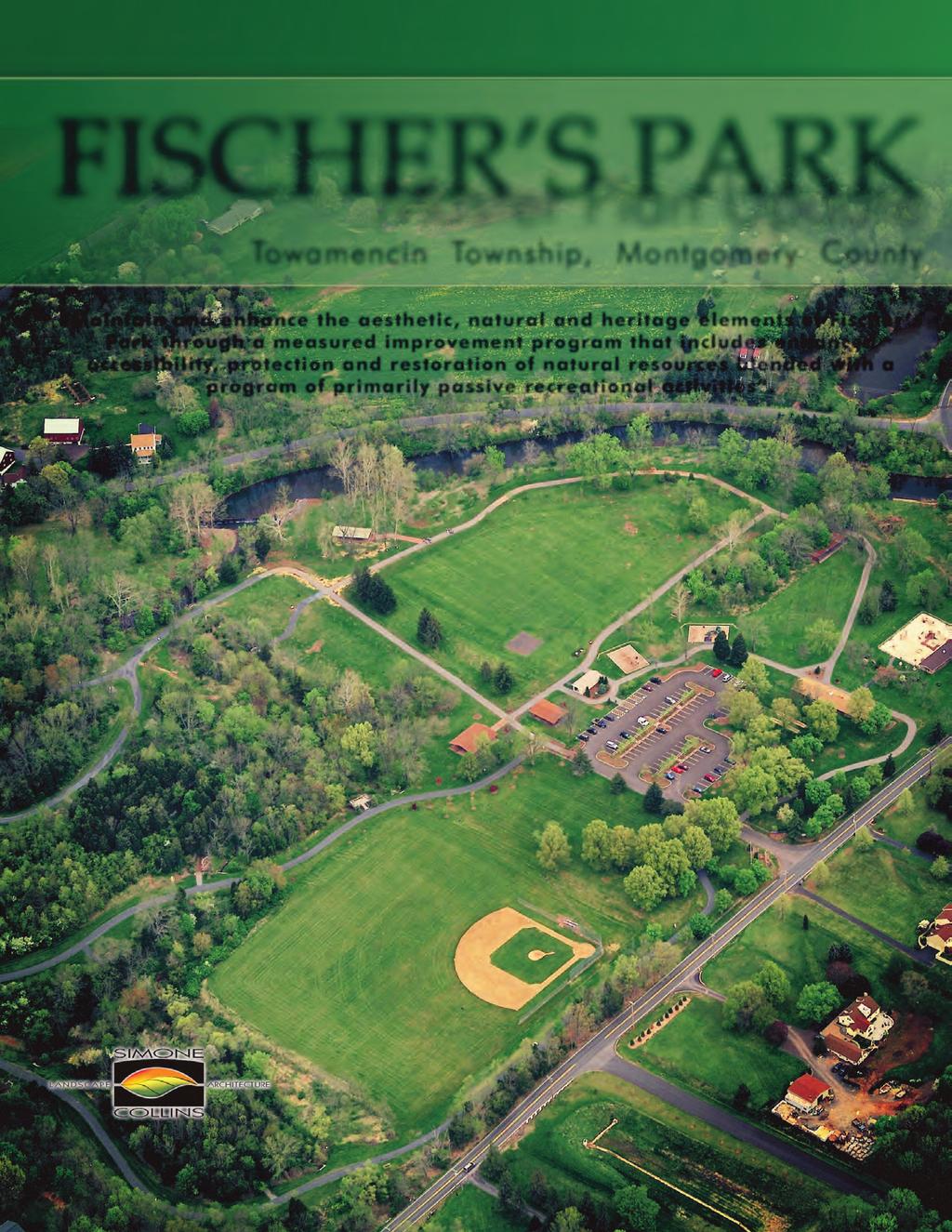
2 Fischer s Park Master Plan Towamencin Township, Montgomery County May 2010 Prepared by Simone Collins Bursich Associates and Urban Partners Mission Statement: Maintain and enhance the aesthetic, natural and heritage elements of Fischer s Park through a measured improvement program that includes enhanced accessibility, protection and restoration of natural resources blended with a program of primarily passive recreational activities. This project was financed in part by a grant from the Community Conservation Partnerships Program, The Keystone Recreation, Park and Conservation Fund under the administration of the Department of Conservation and Natural Resources, Bureau of Recreation and Conservation. Fischer s Park Master Plan Update 1
3 Acknowledgements Open Space and Parks Advisory Committee Joe Meehan, Chair Tom Hollenbeck, BOS Liaison (deceased) Mike Bianchini, Recreation Coordinator Nancy Becker, Resident Rich Marino, Resident Mike Mannes, Resident David Mosesso, Resident Arlene Smith, Resident Bill Jernegan, Easter Seals of SE PA Betsi Strasser, Easter Seals of SE PA Board of Supervisors Daniel M. Littley, Jr., Chairman Thomas M. Hollenbeck, Vice Chairman (deceased) H. Charles Wilson, III, Treasurer James P. Sinz, Secretary John V. Gottschall Patricia Younce Towamencin Staff Robert A. Ford, Manager Sharon Luma, Administrative Assistant David Hillmantel, Director of Public Works Michael Bianchini, Recreation Coordinator 2 Towamencin Township, Montgomery County
4 Table of Contents 1. Introduction Location History Scope of Work Planning Process Open Space and Parks Advisory Committee Committee Meetings Public Meetings Survey Planning summary Overview 1998 Fischer s Park Master Plan Towamencin Township Park, Recreation, and Open Space Preservation Plan Update (Sept. 2006) Township-Wide Trail Master Plan (Jan. 1996) Site analysis Park Assessment Restroom and Pavilions Arneth Tract Structures Play Facilities Trails Park Site Furnishings Dam 25 Fischer s Park Master Plan Update 3
5 2.2 Natural Conditions Hydrology - Creek Corridor Topography Geology Soils Vegetation Circulation Accessibility Analysis Conceptual Elements Connectivity Elements Natural Area Enhancement Elements Access / Mainstreaming Elements Active Elements Master Plan Inclusive Design Enhancements Kriebel Road/ Arneth Improvements Woodland Sensory Garden Resource Restoration Entry Plaza and Inclusive Play Areas 49 4 Towamencin Township, Montgomery County
6 4.6 Evansburg Trail Connector Game Pavilion Area Pedestrian Bridge Universal Softball Field Dam Improvements Fry Road Parking Phasing Estimate of Probable Cost Appendix 55 Meeting Minutes Newspaper Articles Opinion Survey Dam Inspection Report Fischer s Park Master Plan Update 5
7 List of Tables Table Master Plan Recommendations Status 11 Table 2 Survey Highlights 15 Table 3 Table 4 Table 5 Percent Reporting Disability in PA, Percent Reporting Disability in Montgomery County, Percent in Pennsylvania Reporting Disability, Table 6 Local Bird Species 48 Table 7 Local Reptiles and Amphibians 48 List of Figures Figure Year Floodplain 26 Figure 2 Park Soils 28 Figure 3 Master Site Plan 43 6 Towamencin Township, Montgomery County

8 1. Introduction Fischer s Park is a 74-acre passive park located in the southern pan-handle section of Towamencin Township which is located in central Montgomery County, Pennsylvania. It is one of 12 parks in Towamencin, a growing community of nearly 18,000 residents. The Fisher s Park Master Plan Update contains a series of recommended improvements, which were guided by a dedicated committee of residents. The committee adopted a Fischer s Park Master Plan Mission Statement: Maintain and enhance the aesthetic, natural and heritage elements of Fischer s Park through a measured improvement program that includes enhanced accessibility, protection and restoration of natural resources blended with a program of primarily passive recreational activities. This master plan report is divided into four sections that provide: 1) background information on the history and development of Fischer s Park, 2) an analysis of existing conditions and facilities, 3) alternative improvement concepts, and 4) proposed master plan, improvement phasing plan, and cost estimates. Bustard Pond Bridge Fischer s Park Master Plan Update 7


9 1.1 Location Fischer s Park is generally contained by Bustard, Springer, Kriebel, and Metz and Fry Roads. Bustard Road provides the eastern border, and Kriebel and Springer Roads are the park s western border. Kriebel Road also cuts through the northern third of the park, paralleling Towamencin Creek. The southern edge of the park is confined by the rear yards of a handful of residences on Metz and Fry Roads. The park abuts Fry Road, where there is a gap in the line of residences, providing a service access. Primary vehicle access is taken from Bustard Road. The northern section of the park is bordered by residential lands. Towamencin Creek flows east to west through the north central section of the site and effectively divides the park into a southern, heavily-used section, and a northern less-used section. Evansburg State Park is located approximately 1,200 feet to the west of Fischer s Park. SPRINGER KRIEBEL 100 YR. FLOOD PLAIN BUSTARD 100 YR. FLOOD PLAIN FISCHER S PARK MORRIS METZ 8 Towamencin Township, Montgomery County


10 1.2 History A thorough history of Fischer s Park was developed for the 1998 Master Plan. This history includes a chronological timeline, which is shown on the next page. The following summarizes the park s history: The lands that are now Fischer s Park were settled in the 1800s and contained a grist mill known as Kooker s Mill. Mr.. Fischer purchased the mill, adjacent buildings, and 14 acres in the early 1900s. As early as the 1920s, the spot became popular with motorists who would picnic on the property. In the late 1920s, Mr. Fischer began adding facilities to accommodate visitors including a candy and ice cream pavilion, a boardwalk over the dam, cabanas, and a swimming pool. Hugo and Helen Fischer Mr.. Fisher was swept away during a flashflood in 1930 and his widow invited her nephew from Germany, Mr. Arneth, to continue to run the park. From the 1930s through the 1970s Mr.. Arneth made several improvements to the property including the demolition of the mill, construction of the upper club pool, filling of the mill raceway, and some additions to the houses. Kriebel Road / Arneth Farmstead Fischer s Park Master Plan Update 9
, today known as the Arneth home. 1900? Mr.")


11 pre 1750 FISCHER S PARK TIME LINE The mill and house (upper house) on the north side of Kriebel Road were built. The original dam is probably of similar date Ruth Arneth sold five acres which included the old mill to David Fry David Fry built the house (lower house), today known as the Arneth home. 1900? Mr.. Fischer purchased the house and mill with fourteen acres. 1920s Automobile travelers begin picnicking on the Fischer property Mr.. Fischer builds a small pavilion to sell candy and ice cream. Late 1920 s Mill operation ceases - not profitable. Slide erected on creek s edge, boardwalk over dam, several cabanas were built on piers Construction started on swimming pool. Built with a hand crank cement mixer July, the swimming pool is opened for public use (paid admission) Mr.. Fischer, crossing the creek on the foot bridge, was swept away in high water. 1932/3 The widowed Mrs.. Fischer asked her nephew from Germany to help run the park. Twenty-one year old Arneth arrived to help operate the park. 1930s Mill demolished Dining room, powder room, and kitchen addition to Arneth Home. 1935/40 Mill Race filled Porch addition to Arneth Home Upper Club Pool built near Bustard Road. 1965/70 Mr.. Arneth purchased farmstead across Kriebel Road to ward off development of the land Second story added to back of Arneth Home Mr.. Arneth passed away Towamencin Township acquired Fischer s Park. Several buildings were demolished and the pools filled First Master plan for Fischer s Park. Township subsequently makes improvements to the park Construction of parking area, restroom, nature trail and baseball field were completed Towamencin Township acquires Arneth property. 10 Towamencin Township, Montgomery County


12 Towamencin Township purchased the 57-acre Fischer s Park Property south of Towamencin Creek in Many of the buildings, pavilions and pools were in disrepair and were demolished by the Township. The Township continued the use of the property as a park and constructed an enlarged parking area, restroom facility, nature trails, and baseball diamond in In 1996, the Township purchased the Arneth Farmstead on the north side of Towamencin Creek, which includes 23 acres, the former mill site, two houses, and two barns. The Township commissioned the Fischer s Park Master Plan in The plan recommended the development of a number of facilities many of which were constructed and exist today. A number of other recommendations were not achieved due to cost and shifting priorities. Table 1 outlines which recommendations have been completed and which are still under consideration in this plan update. Circa 1960 Recommendation Description Status Parking (main lot) Picnic pavilions Commons Tot lot/play area The main parking lot will be located at the commons and will accommodate 100 paved spaces and 50+ overflow on stabilized turf Four new open picnic pavilions will be located around the central circular common green Four pavilions (above), a gazebo and restrooms located around a central tree-lined lawn area. An environmental play area modeled on Towamencin Creek with water features and paths. The Township also constructed the Arneth Entertainment Center, which was not part of the 1998 Plan. The Center was built in 2006 and is a major attraction with its summer concert series, movie nights, and similar activities. Complete Complete Partially Complete (restroom has been installed) Partially complete. The tot lot and play areas were developed, but the environmental components were not. Baseball field Maintained as a baseball field. Complete Picnic grove Additional picnic tables located adjacent to the pavilions. Not developed Play courts Volleyball courts Not developed Signage A map illustrating trails and features of the park should be located near the drop-off area/commons Complete Kriebel Road Close Kriebel Road Not developed Farmstead The farmstead recommendation included several components for parking, utilities, signage, a pedestrian court, reuse of the structures. Reuse options included a restaurant and conference center, equestrian center, bed and Not developed breakfast, classroom space, nature center, arts center, and others. Riparian buffer Restore the riparian buffer along Towamencin Creek Partially complete. A portion of the creek was stabilized Pedestrian bridge Install a pedestrian bridge across Towamencin Creek Not developed Nursery / Nature preserve Develop a nature/horticultural center at the Metz/Fry Road entrance of the park Table 1: 1998 Master Plan Recommendations Status Trails Specifications for stone dust and asphalt trails were made Complete Complete. The horticultural center was never developed, but the native plant nursery exists. Fischer s Park Master Plan Update 11

13 1998 Fischer s Park Master Plan 12 Towamencin Township, Montgomery County
14 1.3 Scope of Work The Fischer s Park Master Plan Update was developed using a planning process and scope of work that comply with standards specified by the Pennsylvania Department of Conservation and Natural Resources (DCNR) Community Conservation Partnership Program (C2P2). DCNR funded this master plan update in partnership with the Township. The following five steps summarize the scope of work. 1. Programming Programming determines what facilities and activities are needed in the park. The Open Space, Parks and Recreation Advisory Committee as well as the Township Staff and local residents participated in the development of the program. 2. Community Meetings A series of four community meetings were held during the work effort. Public comment was solicited and encouraged as part of the master planning process. 3. Site Analysis The natural and man-made influences of the site were inventoried and analyzed. 4. Concept Design Options The functional relationships for the desired uses were examined and preliminary design plans were developed. 5. Master Plan Design Taking into consideration community comments and suggestions, a final plan, implementation phasing plan, recommendations, and cost estimates were prepared. Fischer s Park Master Plan Update 13

15 1.4 Planning Process Open Space and Parks Advisory Committee The Towamencin Open Space and Parks Advisory Committee guided the development of the Fischer s Park Master Plan Update through the comments at four committee meetings and numerous s and attendance at four public meetings. The committee is comprised of ten members including township residents, staff, and officials. Meetings were conducted by the project consultant team led by Simone Collins Landscape Architecture with support from Bursich Associates, engineers, and Urban Partners, market analysts. Agendas, minutes, handouts, and presentations for each meeting are included in the appendices of this plan. The focus of each meeting is summarized below. Master Plan Committee meeting Committee Meetings June 29 Committee Meeting # 1 Project kick-off and site work held at park. Confirm goals and objectives September 14 Committee Meeting # 2 Review site design options November 9 January 11 Committee Meeting # 3 Review draft plan Committee Meeting # 4 Finalize Changes to the Draft Plan Public Meetings July 14 Public Meeting # 1 Present existing conditions and solicit ideas / get community feedback. October 19 November 16 February 24 Public Meeting # 2 Present options for site improvements Public Meeting # 3 Present Draft Plan Public Meeting # 4 Final Plan Presentation to Board of Supervisors 14 Towamencin Township, Montgomery County
16 Table 2: Survey Highlights Top survey responses are presented below. See the appendix for full survey results. Are you a resident of Towamencin Township? Response Count Yes 128 How frequently do you use the Fischer s Park? Response Count A few times a month 45 During which season(s) do you use the park (check all that apply)? Response Count All year 77 Which days do you use the park? Response Count All days 90 What time of day do you use the park (check all that apply)? Response Count Early evening 55 Why do you visit Fischer s Park (list all that apply)? Response Count Walk the dog 69 Get away 60 Walk the trails 110 What do you like best about Fischer s Park (check all that apply)? Response Count Trails 122 Towamencin Creek 97 Scenery 108 How many people are in your household and what are their ages? Response Total 0 12 years years years years years years 19 Recognizing that organized sport leagues / teams are programmed for other Township Parks, and that Fischer s Park is to remain primarily a passiveuse park, please check the top three potential improvements you would like to see for Fischer s Park. Response Count Pedestrian bridge over 83 Towamencin Creek Fitness stations 42 Improved tot lots 32 Other (please specify) Survey A survey was developed to better understand who uses the park, what amenities they like best and what additional needs are desired. The survey was posted on the Township website, ed to park users, and distributed at the township building in the township s October newsletter. Over 130 responses were recorded and summarized to the left. 1.5 Planning Summary Towamencin Township has developed a number of plans and studies in recent years that contribute to and support the Fischer s Park Master Plan Update. These documents are summarized as follows Fischer s Park Master Plan The 1998 Fischer s Park Master Plan provided an overall design and priorities for the park, including trails, picnic pavilions, and an overflow parking area, all of which have been developed. Recommendations that have not been addressed at the writing of this plan include: Play courts Pedestrian bridge across Towamencin creek A commons area Closing of Kriebel Road within the park Development of the Arneth farmstead Each of these elements was further considered in this update Towamencin Township Park, Recreation, and Open Space Preservation Plan Update (Sept. 2006) The Towamencin Park, Recreation, and Open Space Preservation Plan Update documents existing open space and recreation facilities in the township and makes recommendations for the preservation, improvement and expansion of those facilities. The plan provides three related trail recommendations that are relevant to Fischer s Park. The first is the development of an on-road trail on Kriebel Road running from Lower Salford to the west, through Fischer s Fischer s Park Master Plan Update 15
17 Park, and to residential areas further east. The plan also recommends developing trails connecting to and within Evansburg State Park. The Kriebel Road Trail would provide a portion of this connection. Finally, the plan recommends working with neighboring municipalities and the County on developing trail connections, which would include connecting Fischer s Park to Evansburg Township-Wide Trail Master Plan (Jan. 1996) The Township-Wide Trail Master Plan provides for alternative, non-motor vehicle oriented transportation and recreation opportunities. The plan develops a series of system wide improvement priorities. Relevant improvements include cost estimates for an on-road trail along Kriebel Road connecting Fischer s Park to Evansburg State Park. This improvement ties into a trail proposed by Evansburg State Park that would travel along the north side of Towamencin Creek between Kriebel and Old Forty Foot Road. The development of the state park trail is reported to be planned within the next five to six years, according to state park officials. 16 Towamencin Township, Montgomery County
5.0 Estimate of Probable cost
 5.0 Estimate of Probable cost Fischer s Park Master Plan Update 53 54 Towamencin Township, Montgomery County Fischer's Park Master Plan Update SC# 09033.0 Date: /6/2009 Opinion of Probable Development
Section II. Planning & Public Process Planning for the Baker/Carver Regional Trail began in 2010 as a City of Minnetrista initiative.
 Section II Planning & Public Process Planning for the began in 2010 as a City of initiative. city staff began discussions with the Park District on the possibility of a north/south regional trail connection
Blueways: Rivers, lakes, or streams with public access for recreation that includes fishing, nature observation, and opportunities for boating.
 Parks, Open Space and Trails PRINCE WILLIAM COUNTY 2008 COMPREHENSIVE PLAN TRAILS PLAN CONTENTS The components of the trails plan are: Intent Definitions Goals, Policies, and Action Strategies Trails Map
Chapter 6. Action Program. Heart of the Lakes Area Recreation Plan
 Heart of the Lakes Area Recreation Plan 1. Design and construct the following trails (please see the following map): a. the Speedway Trail 1) primary pathway the main trail 2) secondary pathway the proposed
Chapter 2: Summary of Existing Open Space System
 Chapter 2: Summary of Existing Open Space System In 1976, the Wake County Board of Commissioners established the Wake County Parks and Recreation Department in order to provide park facilities and programs
Lake Myra County Park. Wake County, North Carolina Community Forum #2 June 12, 2008
 Lake Myra County Park Wake County, North Carolina Community Forum #2 June 12, 2008 Welcome and Introduction Meeting Agenda Welcome Introductions of Project Team Master Plan Process Community Forum #1 Updates
MASTER PLAN EXECUTIVE SUMMARY
 Biscuit Run State Park Scottsville Road (State Route 20) Charlottesville, VA 22902 Biscuit Run State Park MASTER PLAN EXECUTIVE SUMMARY Department of Conservation and Recreation Division of Planning and
PALO CORONA REGIONAL PARK MPRPD BOARD MEETING AUGUST 8, 2018
 PALO CORONA REGIONAL PARK MPRPD BOARD MEETING AUGUST 8, 2018 ACKNOWLEDGEMENTS AGENCIES AND ORGANIZATIONS The Trust for Public Land Big Sur Land Trust Santa Lucia Conservancy California State Parks Point
Welcome to the future of Terwillegar Park a Unique Natural Park
 Welcome to the future of Terwillegar Park a Unique Natural Park 1 Introduction The Terwillegar Park Concept Plan study will develop an overall concept plan, management objectives and development guidelines
City of Haslett. City of East Lansing. City of East Lansing
 Central Park North (Nancy L. Moore Park) Lake Park North Expansion White Park Expansion #2 White Park Expansion #1 County East East Haslett East East TF87-212 Acquisition $90,000.00 Park. TF08-138 Acquisition
2. Goals and Policies. The following are the adopted Parks and Trails Goals for Stillwater Township:
 D. PARKS AND TRAILS 1. Introduction Stillwater Township s population is relatively low, with most residents living on rural residences on large lots. The need for active park space has been minimal in
THOMAS A. SWIFT METROPARK Introductions History Present Conditions Future Development Plans Implementation Strategies Statistics
 THOMAS A. SWIFT METROPARK Introductions History Present Conditions Future Development Plans Implementation Strategies Statistics Introduction As an open meadow park positioned along the Mahoning River,
Classifications, Inventory and Level of Service
 Classifications, Inventory and Level of Service Section 3 Kenmore Park, Recreation and Open Space Plan 1 P a g e Classifications and Inventory Park Classifications Kenmore classifies its parks based upon
MINUTES FILED WITH TOWN CLERK
 Page 1 of 7 Town of Farmington Parks Master Plan Advisory Committee FILED WITH TOWN CLERK January 28, 2015 TOWN OF FARMINGTON PARKS MASTER PLAN ADVISORY COMMITTEE MINUTES OF THE MEETING OF JANUARY 28,
Yard Creek Provincial Park. Management Plan
 Yard Creek Provincial Park Management Plan Draft January 2010 Yard Creek Provincial Park Management Plan Approved by: telàlsemkin/siyam/chief Scott Benton Bill Williams Squamish Executive Director ation
Port Gamble Shoreline Area Conceptual Trail Proposal
 The North Kitsap Trails Association is pleased to be a partner to the Kitsap Forest and Bay Project and assist Kitsap County, Forterra, Olympic Property Group, Great Peninsula Conservancy and the Port
THAT the Board approve the final proposed concept plan for the Jericho Marginal Wharf site as shown in Figure C-4 of Appendix C.
 Date: January 17, 2012 TO: Board Members Vancouver Park Board FROM: General Manager Parks and Recreation SUBJECT: Jericho Marginal Wharf Phase 2 Concept Plan RECOMMENDATION THAT the Board approve the final
Longmont to Boulder Regional Trail Jay Road Connection DRAFT FINAL REPORT
 Longmont to Boulder Regional Trail Jay Road Connection DRAFT FINAL REPORT December 2018 Project Summary Boulder County, Colorado, in partnership with the City of Boulder, is evaluating options for multi-use
Dover Park Master Plan. Community Design Event Tuesday, May 22, 5 7 pm
 Dover Park Master Plan Community Design Event Tuesday, May 22, 5 7 pm Agenda I. Introduction / Overview 20 minutes II. Small Group Design Activity 60 minutes III. Small Group Report Out IV. Conclusion
METROPOLITAN COUNCIL 390 North Robert Street, St. Paul, MN Phone (651) TDD (651)
 TDD (651)") DATE: March 27, 2012 METROPOLITAN COUNCIL 390 North Robert Street, St. Paul, MN 55101 Phone (651) 602-1000 TDD (651) 291-0904 TO: Metropolitan Parks and Open Space Commission FROM: Arne Stefferud, Planning
DATE: March 27, 2012 METROPOLITAN COUNCIL 390 North Robert Street, St. Paul, MN 55101 Phone (651) 602-1000 TDD (651) 291-0904 TO: Metropolitan Parks and Open Space Commission FROM: Arne Stefferud, Planning
The Recreational Trail along Cushing Park road has been a successful addition to the city
 The Recreational Trail along Cushing Park road has been a successful addition to the city Trails TRAILS, PATHS, ROUTES AND CONNECTORS Citizen input pointed to trails, paths, bike routes, and other non-motorized
BRYAN REGIONAL PARK. Presented by: Burditt Consultants November 13, 2018
 BRYAN REGIONAL PARK Presented by: Burditt Consultants November 13, 2018 AGENDA 1. Project Purpose & Mission 2. Project Vision & Goals 3. Stakeholder Feedback 4. Program Overview 5. Phase A Plan Overview
City of Durango 5.8 FUNDING TRAILS DEVELOPMENT
 5.8 FUNDING TRAILS DEVELOPMENT The City has been successful in establishing dedicated local funding sources as well as applying for grants to develop the City s trail system, having received nearly $2.4
Welcome and thank you for being here! Kick-Off Public Workshop November 19, 2014
 Welcome and thank you for being here! Kick-Off Public Workshop November 19, 2014 OPEN SPACE MATTERS: Boise s First Reserve Master Plan Julia Grant Foothills and Open Space Manager City of Boise Ellen Campfield
Appendix 3. Greenway Design Standards. The Whitemarsh Township Greenway Plan
 Appendix 3 Greenway Design Standards This chapter discusses two design standards for the greenway types discussed above. First, trail design standards are presented together with trailhead facilities and
3.0 LEARNING FROM CHATHAM-KENT S CITIZENS
 3.0 LEARNING FROM CHATHAM-KENT S CITIZENS An important aspect in developing the Chatham-Kent Trails Master Plan was to obtain input from stakeholders and the general public. Throughout the course of the
MONTEREY REGIONAL AIRPORT MASTER PLAN TOPICAL QUESTIONS FROM THE PLANNING ADVISORY COMMITTEE AND TOPICAL RESPONSES
 MONTEREY REGIONAL AIRPORT MASTER PLAN TOPICAL QUESTIONS FROM THE PLANNING ADVISORY COMMITTEE AND TOPICAL RESPONSES Recurring topics emerged in some of the comments and questions raised by members of the
Silver Lake Park An Environmental Jewel for the Citizens of Prince William County
 Silver Lake Park An Environmental Jewel for the Citizens of Prince William County The Prince William Park Authority Mission Statement states: The Prince William County Park Authority will create quality
Flow Stand Up Paddle Board Parkway Plan Analysis
 Regional Parks Department Jeffrey R. Leatherman, Director County of Sacramento Divisions Administration Golf Leisure Services Maintenance Rangers Therapeutic Recreation Services Flow Stand Up Paddle Board
OAKLAND TOWNSHIP PARKS AND RECREATION MILLAGE RENEWAL AUGUST 2, 2016 BALLOT PROPOSAL QUESTIONS & ANSWERS PULL-OUT SECTION (APRIL 21, 2016)
") OAKLAND TOWNSHIP PARKS AND RECREATION MILLAGE RENEWAL AUGUST 2, 2016 BALLOT PROPOSAL QUESTIONS & ANSWERS PULL-OUT SECTION (APRIL 21, 2016) 2007 2016 Millage Accomplishments Timeline in Pull-out The Mission
OAKLAND TOWNSHIP PARKS AND RECREATION MILLAGE RENEWAL AUGUST 2, 2016 BALLOT PROPOSAL QUESTIONS & ANSWERS PULL-OUT SECTION (APRIL 21, 2016) 2007 2016 Millage Accomplishments Timeline in Pull-out The Mission
YOU CAN MAKE A DIFFERENCE! VISIONING SESSION FOR THREAD LAKE OCTOBER 8, 2013
 YOU CAN MAKE A DIFFERENCE! VISIONING SESSION FOR THREAD LAKE OCTOBER 8, 2013 PEOPLE IN NEIGHBORHOODS & INSTITUTIONS ARE BUILDING A BETTER FLINT RIGHT NOW! DIPLOMAT PHARMACY GENESSEE COUNTY LAND BANK FLINT
Waterfront Concept Plan: Community Survey Summary
 Waterfront Concept Plan: Community Survey Summary Published April 20, 2016 #1100085 Introduction The survey was one component of the public consultation process endorsed by Council in October, 2015. This
PIONEER PARK. City of Des Peres Parks Master Plan. SWT Design 46 INTRODUCTION
 PIONEER PARK INTRODUCTION Pioneer Park is a 7 acre neighborhood park located east of Interstate 270 and south of Manchester Road along Tallie Road. The park is situated in a residential neighborhood with
China Creek North Park Upgrades and Glen Pump Station. Park Board Committee Meeting Monday, July 10, 2017
 China Creek North Park Upgrades and Glen Pump Station Park Board Committee Meeting Monday, July 10, 2017 Purpose The purpose of this presentation is to: Share the results of the public engagement processes;
Committee. Presentation Outline
 CW-33-15 11/9/2015 Community and Corporate Services Committee November 10, 2015 1 Presentation Outline Background Vision and Objectives Study Process and Timeline Public and Stakeholder Engagement Organization
Acquisition in fee simple of approximately one-half acre of property on the shore of Spring Lake to expand the Lakeside Beach Park.
 Lakeside Beach TF00-136 $122,550.00 in fee simple of approximately one-half acre of property on the shore of Spring Lake to exp the Lakeside Beach. 2000 River Ravines TF00-150 $910,000.00 in fee simple
NORTH HEMPSTEAD BEACH PARK MASTER PLAN
 NORTH HEMPSTEAD BEACH PARK MASTER PLAN COMMUNITY DESIGN CHARRETTE Supervisor Judi Bosworth Viviana L. Russell Peter J. Zuckerman Angelo P. Ferrara Anna M. Kaplan Lee R. Seeman Dina M. De Giorgio VISIONING
COCONUT GROVE WATERFRONT MASTER PLAN. ERA / Curtis Rogers / ConsulTech / Paul George Ph.D.
 COCONUT GROVE WATERFRONT MASTER PLAN ERA / Curtis Rogers / ConsulTech / Paul George Ph.D. Agenda City's Vision & Community Input Framework Concepts December 2006 Schemes Draft Final Plan Waterfront Open
LANDING S PARK CONCEPTUAL PLAN HAMILTON ANDERSON JANUARY City of Novi, Michigan. The Park at 13 Mile and Old Novi Road
 HAMILTON ANDERSON JANUARY 2012 LANDING S PARK CONCEPTUAL PLAN January 2012 Page 1 of 15 January 2012 PROJECT GOALS Activate the park by introducing new elements Provide clear access to the water and enhance
M E S T I Z O C U R T I S P A R K
 ARAPAHOE CONNECTION TO BUS ROUTE AT ND AND LAWRENCE, FUTURE LIGHT RAIL STATION LEGEND SOCIAL TRAIL FLAGSTONE PAVING TO RESTORE/MAINTAIN CONCRETE PAVING DIAGONAL CURVILINEAR SOCIAL ROUTE IS OUT OF HISTORIC
Fair Oaks Ranch Homeowners Association Parks and Trails Master Plan Survey Results
 Fair Oaks Ranch Homeowners Association Parks and Trails Master Plan Survey Results Survey Analysis Process Team of professionals developed, administered & analyzed 1 web administrator with 14 years relevant
Great Wolf Lodge Fact Sheet & Frequently Asked Questions Potential Location in Gilroy, California 8/30/17
 WHAT? Great Wolf Resorts has identified Gilroy, California as a potential location for a new Great Wolf Lodge family resort and has entered into a 60-day period of exclusivity with the City and community
1803 West Hwy 160 Monte Vista, CO (719) TTY (719)
 TTY (719)") USDA Forest Service Rio Grande National Forest http://www.fs.fed.us/r2/riogrande 1803 West Hwy 160 Monte Vista, CO 81144 (719)852-5941 TTY (719)852-6271 USDI Bureau of Land Management San Luis Valley Center
USDA Forest Service Rio Grande National Forest http://www.fs.fed.us/r2/riogrande 1803 West Hwy 160 Monte Vista, CO 81144 (719)852-5941 TTY (719)852-6271 USDI Bureau of Land Management San Luis Valley Center
Plaza Park, Village Park, and Community Clubhouse
 Plaza Park, Village Park, and Community Clubhouse Agenda Introduction (10 minutes) Presentation (30 minutes) Project Background Master Plan Process Site History and Context Site Analysis User Group Summary
JOSLIN FIELD, MAGIC VALLEY REGIONAL AIRPORT DECEMBER 2012
 1. Introduction The Federal Aviation Administration (FAA) recommends that airport master plans be updated every 5 years or as necessary to keep them current. The Master Plan for Joslin Field, Magic Valley
Community Advisory Committee Meeting #3 April 21, 2015
 Community Advisory Committee Meeting #3 April 21, 2015 Purpose (charge) of the CAC: Be Knowledgeable, Be an Engaged Representative, Develop Master Plan, & Prioritize Plan 1 Welcome/ Introductions Review
EXECUTIVE SUMMARY PROGRAM DEVELOPMENT REPORT PURPOSE EXISTING SETTING EXPANDING PARKLAND
 EXECUTIVE SUMMARY PROGRAM DEVELOPMENT REPORT PURPOSE As the culmination of the first phase of the master planning process, this Program Development Report creates the framework to develop the Calero County
Public Park System. Township of Derry. Providing natural open space for the recreational use of our residents and guests.
 Township of Derry Public Park System Providing natural open space for the recreational use of our residents and guests. Directory of Recreational Amenities Hershey s Commitment to Recreation Famous candy
David Johnson. Tom, Attached please find the final scoping letter and figures for your review. David
 David Johnson From: Sent: To: Cc: Subject: Attachments: David Johnson Tuesday, April 12, 2011 4:33 PM Thomas Malecek Dave Dyer; Jason Marks (jmarks@segroup.com) VWC Scoping Letter
STORY MILL COMMUNITY PARK
 OWNER: City of Bozeman Department or Parks and Recreation P.O. Box 1230, 415 N. Bozeman Street Bozeman, MT 59715 Tel: (406)-582-2908 APPLICANT: The Trust for Public Land 1007 E. Main Street, Suite 300
Northeast Quadrant Distinctive Features
 NORTHEAST QUADRANT Northeast Quadrant Distinctive Features LAND USE The Northeast Quadrant includes all the area within the planning area that is east of Interstate 5 and to the north of State Route 44.
Establishing a National Urban Park in the Rouge Valley
 STAFF REPORT ACTION REQUIRED Establishing a National Urban Park in the Rouge Valley Date: March 29, 2012 To: From: Wards: Reference Number: Executive Committee Deputy City Manager, Cluster B All p:\2012\cluster
J. Recreation Plan of Conservation and Development. The Town of Hebron. Section 2. Preservation of Unique Assets. 1 P a g e
 The Town of Hebron Section 2 2014 Plan of Conservation and Development Preservation of Unique Assets J. Recreation Open spaces, parks, sports fields, and recreational programs are considered essential
Chuckanut Ridge Fairhaven Highlands EIS Scoping Concerns
 Chuckanut Ridge Fairhaven Highlands EIS Scoping Concerns Coalition of Southside Neighborhoods CSN Comments for Fairhaven Highlands EIS Scope Hearing, Jan 16, 2008 1 Chuckanut Ridge Hilly Terrain: Potential
Georgetown-Lewes Rail/Trail Study. Rail/Trail Study: Cool Spring to Cape Henlopen State Park New Road Extension (House Resolution No.
 Georgetown-Lewes Rail/Trail Study Rail/Trail Study: Cool Spring to Cape Henlopen State Park New Road Extension (House Resolution No. 47) August 22, 2011 Presentation Outline Background Benefits Statewide
CITY COUNCIL MARCH 15, 2016 CEDAR LAKE AND LAKE OLATHE PARKS MASTER PLAN. Lake Olathe and Cedar Lake Parks Olathe, Kansas OLATHE PARKS AND RECREATION
 CITY COUNCIL MARCH 15, 2016 MASTER PLAN TEAM STAFF: MICHAEL MEADORS PARKS DIRECTOR MICHAEL LATKA PROJECT MANAGER BRAD CLAY DEPUTY DIRECTOR LISA DONNELLY PARK PROJECT PLANNER PAUL KRUEGER OLATHE PARKS CITY
Parks, Recreation and Cultural Needs Assessment and Facilities Plan. November 21, 2016 City Council Worksession
 Parks, Recreation and Cultural Needs Assessment and Facilities Plan November 21, 2016 City Council Worksession History and Process FY16/17 Budget Appropriation for Needs Assessment, Dean and Stonewall
Rockin River Ranch State Park
 Rockin River Ranch State Park Public Meeting No. 3 August 16 th, 2017 Arizona State Parks and Trails (ASPT) Welcome Executive Director Sue Black Park budget = $4 million Balance of recreation uses, environment,
AGENDA ITEM 5 D WAKULLA ENVIRONMENTAL INSTITUTE (WEI) TRAIL FEASIBILITY STUDY
 TRAIL FEASIBILITY STUDY") March 19, 2018 AGENDA ITEM 5 D WAKULLA ENVIRONMENTAL INSTITUTE (WEI) TRAIL FEASIBILITY STUDY TYPE OF ITEM: Action STATEMENT OF ISSUE The Wakulla Environmental Institute (WEI) Trail is one of several trails
March 19, 2018 AGENDA ITEM 5 D WAKULLA ENVIRONMENTAL INSTITUTE (WEI) TRAIL FEASIBILITY STUDY TYPE OF ITEM: Action STATEMENT OF ISSUE The Wakulla Environmental Institute (WEI) Trail is one of several trails
Tracy Ridge Shared Use Trails and Plan Amendment Project
 Tracy Ridge Shared Use Trails and Plan Amendment Project Scoping Document Forest Service Allegheny National Forest Bradford Ranger District McKean, County, Pennsylvania In accordance with Federal civil
Logo Department Name Agency Organization Organization Address Information 5700 North Sabino Canyon Road
 Logo Department Name Agency Organization Organization Address Information United States Forest Coronado National Forest 5700 North Sabino Canyon Road Department of Service Santa Catalina Ranger District
Trail Etiquette. Hours of Operation. Trail Accessibility
 Trail Guide The Elmhurst Park District, with 28 parks and over 460 acres of land, offers nearly six miles of paved or asphalt park trails and maintains an additional 3.6 miles of trails within Elmhurst.
MONTVILLE PARKS AND RECREATION COMMISSION REGULAR MEETING JUNE 17, 2009 CAMP OAKDALE LOWER PAVILION
 MONTVILLE PARKS AND RECREATION COMMISSION REGULAR MEETING JUNE 17, 2009 CAMP OAKDALE LOWER PAVILION Called to order at 6:02 p.m. by Chairman Gwudz Roll Call Joe Berardy Absent Eileen Cicchese Absent for
FEASIBILITY STUDY. holdings SEPTEMBER 13, prepared for: prepared by:
 FEASIBILITY STUDY SEPTEMBER 13, 2013 prepared for: holdings prepared by: Table of Contents Project Feasibility... 3 Project Background... 4 Project and Community Context... 5 Site constraints... 6 Statement
PEMBERTON VALLEY RECREATIONAL TRAILS MASTER PLAN UPDATE Community Open House. April 2018
 PEMBERTON VALLEY RECREATIONAL TRAILS MASTER PLAN UPDATE Community Open House April 2018 Introductions Introductions Matt Bakker, BHA Project Coordinator Other Team Members: Liz Scroggins, Grey Owl Consulting
SAN ANTONIO RIVER IMPROVEMENTS PROJECT. April 27, 2009
 SAN ANTONIO RIVER IMPROVEMENTS PROJECT April 27, 2009 1 Project Limits 2 Project Partners City of San Antonio Provides project funding for project amenities (i.e.. Sidewalks, Landscaping, Lighting, etc.)
Former Middle School Site Green Space & Brecksville Road Streetscape. March 27, 2018
 Former Middle School Site Green Space & Brecksville Road Streetscape March 27, 2018 Brecksville Streetscape & Downtown Greenspace Project Schedule City of Indepenence 2017 2018 Meeting Schedule Tasks/Deliverables
White Mountain National Forest Saco Ranger District
 United States Department of Agriculture Forest Service White Mountain National Forest Saco Ranger District 33 Kancamagus Highway Conway, NH 03818 Comm: (603) 447-5448 TTY: (603) 447-3121 File Code: 1950
National Forests and Grasslands in Texas
 United States Department of Agriculture Forest Service National Forests and Grasslands in Texas Sam Houston NF 394 FM 1375 West New Waverly, Texas 77358 Phone 936-344-6205 Dear Friends, File Code: 1950
WEST JORDAN PARKS, RECREATION AND TRAILS MASTER PLAN Advisory Committee Meeting #2
 WEST JORDAN PARKS, RECREATION AND TRAILS MASTER PLAN Advisory Committee Meeting #2 MONDAY, NOVEMBER 5, 2018, 6:00 P.M.; PARKS DEPT. CONFERENCE ROOM ATTENDEES: Lisa Dean Larry Gardner Duane Harding David
Chapter 1: Introduction Draft
 Chapter 1: Draft TABLE OF CONTENTS 1... 4 1.6.1 Stakeholder Engagement Plan... 10 Chapter 1 Page 2 TABLE OF EXHIBITS Exhibit 1.1-1 ABIA Annual Growth Since 1993... 5 Exhibit 1.4-1: ABIA Location Map...
FEASIBILITY CRITERIA
 This chapter describes the methodology and criteria used to evaluate the feasibility of developing trails throughout the study areas. Land availability, habitat sensitivity, roadway crossings and on-street
Frederickson LUAC. Community Plan Update. Parks & Recreation. September 25, 2017
 Frederickson LUAC Community Plan Update Parks & Recreation September 25, 2017 Kimberly Freeman Resource Stewardship Superintendent kimberly.freeman@co.pierce.wa.us 253-798-4261 Joseph Coppo Senior Parks
2016 Regional Transportation Alternatives Program (TAP) Grant Application
 Grant Application") 2016 Regional Transportation Alternatives Program (TAP) Grant Application PROJECT TITLE: Yelm-Tenino Trail Extension Feasibility Study TRPC use only GENERAL PROJECT INFORMATION Agency or Organization City
2016 Regional Transportation Alternatives Program (TAP) Grant Application PROJECT TITLE: Yelm-Tenino Trail Extension Feasibility Study TRPC use only GENERAL PROJECT INFORMATION Agency or Organization City
Macleod Trail Corridor Study. Welcome. Macleod Trail Corridor Study Open House. Presentation of Proposed Design Concepts
 Macleod Trail Corridor Study Welcome Macleod Trail Corridor Study Open House Presentation of Proposed Design Concepts Study Purpose Develop a corridor plan for Macleod Trail that aligns with The City s:
Dakota County Planning Commission Advisory Committee Meeting Minutes Date: May 23, 2017 Time: 6:00 p.m. to 8:30 p.m.
 Dakota County Planning Commission Advisory Committee Meeting Minutes Date: May 23, 2017 Time: 6:00 p.m. to 8:30 p.m. Members Present Staff Present Mike Greco Trinity Augesen Vacant Lori Hansen Jill Smith
Stambaugh Township 5-Year Recreation Plan - DRAFT
 Stambaugh Township 5-Year Recreation Plan - DRAFT Stambaugh Township GEI Project No. 1702677 January 5, 2018 Table of Contents 1. Community Description 1 2. Administrative Structure 2 3. Recreation Inventory
Otter Lake Landowners Association (OLLA) Otter Lake News
 Otter Lake News") Otter Lake Landowners Association (OLLA) Otter Lake News Visit our website: www.otterlake.org Spring 2018 Follow us on Facebook: Otter-Lake-Landowners-Association IN THIS ISSUE: FROM THE PRESIDENT S DESK...
Otter Lake Landowners Association (OLLA) Otter Lake News Visit our website: www.otterlake.org Spring 2018 Follow us on Facebook: Otter-Lake-Landowners-Association IN THIS ISSUE: FROM THE PRESIDENT S DESK...
SOUTH INTERCHANGE AREA
 Santaquin City General Plan 1 Location and Characteristics The South Interchange Area of Santaquin is located west of Interstate 15 and south of 500 South (Figure 1). It includes properties already annexed
NORTHWEST SECTION CONTENTS: CLEVELAND PARK FOLWELL PARK RYAN LAKE PARK VICTORY PRAIRIE DOG PARK VICTORY PARK
 NORTHWEST SECTION CONTENTS: CLEVELAND PARK FOLWELL PARK RYAN LAKE PARK VICTORY PRAIRIE DOG PARK VICTORY PARK LUCY LANEY COMMUNITY SCHOOL N 33RD AVE N 33RD AVE SINGLE-FAMILY RESIDENTIAL MULTI-USE DIAMOND
The presentation was approximately 25 minutes The presentation is part of Working Group Meeting 3
 This is the presentation for the third Master Plan Update Working Group Meeting being conducted for the Ted Stevens Anchorage International Airport Master Plan Update. It was given on Thursday March 7
Dungeness Recreation Area County Park Master Plan
 Dungeness Recreation Area County Park Public Outreach Meeting October 10, 2007 Project Overview USFWS Site Dungeness Recreation Area County Park Meeting Objectives: Re-Introduce project; provide status
MINUTES OF THE SPECIAL MEETING OF THE LADY LAKE TOWN COMMISSION LADY LAKE, FLORIDA June 20, 2016
 MINUTES OF THE SPECIAL MEETING OF THE LADY LAKE TOWN COMMISSION LADY LAKE, FLORIDA The Special Meeting of the Lady Lake Town Commission was held in the Commission Chambers at Lady Lake Town Hall, 409 Fennell
CHAPTER 1: INTRODUCTION
 CHAPTER 1: INTRODUCTION Purpose and Scope The information presented in this report represents the study findings for the 2016 Ronan Airport Master Plan prepared for the City of Ronan and Lake County, the
TRUCKEE TAHOE AIRPORT DISTRICT BOARD OF DIRECTOR STAFF REPORT
 AGENDA ITEM: 11 TRUCKEE TAHOE AIRPORT DISTRICT BOARD OF DIRECTOR STAFF REPORT AGENDA TITLE: MEETING DATE: January 24, 2018 PREPARED BY: NTPUD Agency Partnership Opportunity, Multi-Use Trailhead Access
Chapter 9 Recreation
 Chapter 9 Chapter 9 1.0 INTRODUCTION The Town of Littleton is within one of New England s most important recreation areas. More than three million people live within 100 miles of the area. Local residents
Fossil Creek Wild & Scenic River Comprehensive River Management Plan Forest Service Proposed Action - details March 28, 2011
 Fossil Creek Wild & Scenic River Comprehensive River Management Plan Forest Service Proposed Action - details March 28, 2011 Primary Goals of the Proposed Action 1. Maintain or enhance ORVs primarily by
Nantucket Memorial Airport Master Plan Update
 Nantucket Memorial Airport Master Plan Update CHAPTER 1 - INTRODUCTION & PUBLIC OUTREACH PROGRAM REVIEW DRAFT SUBJECT TO CHANGE Prepared for: Nantucket Memorial Airport Commission 14 Airport Road Nantucket,
Rogue River Access and Management Plan Draft Alternatives
 Rogue River Access and Management Plan Draft Alternatives The Rogue River Access and Management Plan was initiated in December, 2011 and is being led by Jackson County Parks (JCP) and Oregon Department
EAST DON TRAIL ENVIRONMENTAL ASSESSMENT. Community Liaison Committee Meeting #3 July 15, :30 to 8:30 pm Flemingdon Park Library
 EAST DON TRAIL ENVIRONMENTAL ASSESSMENT Community Liaison Committee Meeting #3 July 15, 2013 6:30 to 8:30 pm Flemingdon Park Library Agenda 1. Welcome 2. Housekeeping and Updates a) Housekeeping b) CLC
1. Overview of Aberdeen Township and Its Waterfront
 Aberdeen 1. Overview of Aberdeen Township and Its Waterfront 1.1 Geographic Overview Aberdeen Township is a suburban township with a land area of 5.45 square miles, with about 2 miles of shoreline along
Clam Harbour Provincial Park
 Clam Harbour Provincial Park Public Engagement Session Thursday, September 14 th, 2017 5:30pm 7:30pm Webbers Store 11470 Nova Scotia Trunk 7 Lake Charlotte, NS Agenda Overview of the Provincial Parks System
Safety, Infrastructure, and Tenant Improvement Project. Public Hearing Informational Brochure February 26, 2013
 New York State Department of Transportation Safety, Infrastructure, and Tenant Improvement Project Public Hearing Informational Brochure February 26, 2013 This DEIS/Draft EA evaluates the potential impacts
Auburn Trail / Ontario Pathways Trail Connector Feasibility Study Public Information Meeting Wednesday, August 22, 2012
 Auburn Trail / Ontario Pathways Trail Connector Feasibility Study Public Information Meeting Wednesday, August 22, 2012 Purpose of Feasibility Study Purpose Evaluate the feasibility of constructing a multiuse
Daisy Dean Trail 628/619 ATV Trail Construction
 Background and Purpose and Need The Daisy Dean ATV Trail Construction Project is located in the Little Belt Mountains, Musselshell Ranger District, Lewis and Clark National Forest approximately 32 miles
APPLICATION FOR SITE DEVELOPMENT PLAN LETTER OF INTENT Amended
 Est. 1982 Est. 1982 Urban Planning Community Design Landscape Architecture 731 North Weber Street, Suite 10, Colorado Springs, CO 80903, 719 633-9700 http://www.gumanltd.com/ Members American society of
crrv OF DALLAS Memorandum Trinity River Corridor Project Update On Recreation
 Memorandum OATE December 8, 2011 crrv OF DALLAS TO Trinity River Corridor Project Committee Members: Vonciel Jones Hill (Chair) Linda Koop (Vice Chair), Monica Alonzo, Scott Griggs, Angela Hunt, Delia
DRAFT GENERAL IMPLEMENTATION PLAN AND SPECIFIC IMPLEMENTATION PLAN MIDDLETON MUNICIPAL AIRPORT MOREY FIELD. Revised 12/12/03
 DRAFT GENERAL IMPLEMENTATION PLAN AND SPECIFIC IMPLEMENTATION PLAN MIDDLETON MUNICIPAL AIRPORT MOREY FIELD Revised 12/12/03 As recommended for approval by the Plan Commission General Project Description
4MRV Parks Master Plan: Site Analysis
 4MRV Parks Master Plan: Site Analysis Lardner/Klein Landscape Architects in association with: RK&K Grimm + Parker Kittelson & Associates Partners for Economic Solutions RIB U.S.Cost Civil Engineering Architecture
NEWBORO AND PORTLAND HARBOUR REDVELOPMENT PLANS
 INTRODUCTION The Municipal docks in both Newboro and Portland were transferred to the Township of Rideau Lakes by Parks Canada in 2002. Little has been done to improve the docks physical condition or role