Final Project Report 2010 Eastern Lake Ontario Upper Watershed AIS Response Team
|
|
|
- Jeffry Stone
- 5 years ago
- Views:
Transcription

1 Final Project Report 2010 Eastern Lake Ontario Upper Watershed AIS Response Team Daniel L. Kelting Executive Director Paul Smith s College Adirondack Watershed Institute GLRI/USFS Grant # B-G010
2 Table of Contents List of Tables... iii List of Figures and Photographs... iv Eastern Lake Ontario Upper Watershed AIS Response Team... 1 Project Summary... 1 Early Detection... 3 Rapid Response... 7 Results... 9 Early Detection Team... 9 Invasive Plant Images Rapid Response Team Appendix 1. Field Datasheet for Early Detection Team Appendix 2. Rake Toss Protocol Appendix 3. Aquatic Plant Surveys Barnum Pond Aquatic Plant Survey Beaver Lake Aquatic Plant Survey Blake Falls Reservoir Aquatic Plant Survey Carry Falls Reservoir Aquatic Plant Survey Church Pond & Little Osgood Aquatic Plant Survey Clear Pond (Parishville) Aquatic Plant Survey Clear Pond (Lewis County) Aquatic Plant Survey Cleveland Lake Aquatic Plant Survey Colby Lake & Little Colby Aquatic Plant Survey Cranberry Lake Aquatic Plant Survey Five Falls Reservoir Aquatic Plant Survey Kushaqua Lake Aquatic Plant Survey Little River Flow Aquatic Plant Survey Long Lake Aquatic Plant Survey Long Pond Aquatic Plant Survey Lower St. Regis Lake Aquatic Plant Survey i
3 Meacham Lake Aquatic Plant Survey Moshier Reservoir Aquatic Plant Survey Mountain Pond Aquatic Plant Survey Mud Pond Aquatic Plant Survey Osgood Pond Aquatic Plant Survey Ozonia Lake Aquatic Plant Survey Payne Lake Aquatic Plant Survey Quiver Pond Aquatic Plant Survey Rainbow Falls Reservoir Aquatic Plant Survey Rainbow Lake & Clear Pond (Rainbow Lake) Aquatic Plant Survey Rock Pond Aquatic Plant Survey Rondaxe Lake Aquatic Plant Survey Soft Maple Reservoir Aquatic Plant Survey Spitfire Lake & Slough Aquatic Plant Survey St. Regis River Aquatic Plant Survey Stark Falls Reservoir Aquatic Plant Survey Trout Pond Aquatic Plant Survey Upper St. Regis Lake Aquatic Plant Survey ii
4 List of Tables Table 1. Names and locations of the 30 lakes and ponds surveyed in 2012 within the Great Lakes Region of the Adirondack Park, New York, and the species of aquatic invasive plants detected in each waterbody Table 2. Dates, locations, and Eurasian watermilfoil removals conducted by the Rapid Response Team within the Great Lakes Region of the Adirondack Park during the summers of 2011 and iii
5 List of Figures and Photographs Figure 1. Three major drainage basins within the Adirondack Park and locations of lakes worked on by the EDRR teams in 2011 and Figure 2. Locations of the 30 lakes and ponds surveyed in 2012 within the Great Lakes Watershed region of the Adirondack Park, New York. Colored circles indicate the species of aquatic invasive plants detected Figure 3. Locations of rapid response work in Second, Fourth, and Fifth Lakes within the Fulton Chain of Lakes Photo 1. Early detection survey team shown with the canoes used for most surveys. From left to right they are Josh Fitzgerald, Virginia Brink, Kimberly Forrest, and Josh Pierce (crew chief) Photo 2. Kim Forrest and Josh Pierce identify and map species of aquatic plants in Barnum Pond from a canoe Photo 3. Josh Fitzgerald conducts a surface survey of Stillwater Reservoir. When possible large lakes are surveyed using a combination of canoes and motorboats Photo 4. Josh Pierce identifies a species of aquatic plant after performing a rake toss in Lake Meacham.. 6 Photo 5. Rapid response management team with boat and diver gear preparing to travel to the Fulton Chain of Lakes. From left to right they are Zach Davidson, Alex Lecheminant, Sean Regalado, and Tim Worth (crew chief) Photo 6. Rapid response management team hand harvesting Eurasian watermilfoil in the Fulton Chain. Note yellow hoses supplying air to the divers from the hookah rig and the green bags filled with milfoil on the deck of the kayak Photo 7. Underwater photograph of Eurasian watermilfoil taken in Lake Colby on July 13, Photo 8. Surface water photograph of Eurasian watermilfoil taken in Lake Colby on July 13, Photo 9. Underwater photograph of Variable-leaf milfoil taken in Stark Falls Reservoir on June 19, Photo 10. Surface water photograph of Variable-leaf milfoil taken in Stark Falls Reservoir on June 19, Photo 11. Photograph of flowering structures of Variable-leaf milfoil taken from Stark Falls Reservoir on June 19, Note the entire and finely-divided leaves that give this species its name are easily seen.. 16 iv
6 Eastern Lake Ontario Upper Watershed AIS Response Team Project Summary The Eastern Lake Ontario Upper Watershed AIS Response Team was established in September 2010 as a landscape level aquatic invasive species Early Detection / Rapid Response (EDRR) team. The EDRR team worked within the Great Lakes portion of the Adirondack Park (Figure 1). The EDRR team began work in the summer of 2011 with an initial focus on rapid response work in the Fulton Chain of Lakes to eradicate a new population of Eurasian watermilfoil that was discovered during a lake survey in During the winter of 2011/2012 a priority waters list for surveillance was developed collaboratively with Hilary Smith and Meghan Johnstone of the Adirondack Park Invasive Plant Program (APIPP), and early detection surveillance work commenced in the summer of We performed EDRR using two teams, an Early Detection (ED) team surveyed lakes and a Rapid Response (RR) team performed eradication. The ED team surveyed 30 lakes in Ten of these lakes had AIS present (1 Eurasian watermilfoil (EWM) and 9 Variable-leaf milfoil (VLM)), with 9 of these lakes with well established populations of VLM and 1 of these lakes with a scattered low-density population of EWM. The EWM was found in Meacham Lake in late summer and we decided to forgo any management until the following year. The RR team performed EWM eradication in Second, Fourth, and Fifth Lakes within the Fulton Chain of Lakes. EWM eradication from Second and Fourth Lakes was initiated prior to this project and no new plants were observed in either of these lakes in 2011 or EWM eradication from Fifth Lake was initiated in 2011, with 4,050 pounds removed that summer and 175 pounds removed in The lack of EWM regrowth in Second and Fourth Lakes in the two years proceeding removal indicate a successful eradication and the large year-to-year reduction in EWM removal from Fifth Lake suggests eradication is likely within this water body as well, though more years of removal effort and follow-up monitoring will be needed. Our very positive results with EWM removal from the Fulton Chain highlight the value of EDRR in managing AIS, as in the absence of the EDRR team EWM and other AIS could rapidly become established. The Eastern Lake Ontario Upper Watershed AIS Response Team continues its early detection and rapid response work. 1

7 Figure 1. Three major drainage basins within the Adirondack Park and locations of lakes worked on by the EDRR teams in 2011 and

8 Early Detection The ED team performed whole lake aquatic plant surveys using a combination of visual surveys and rake tossing. The team surveyed the entire littoral zone of each lake in a serpentine search pattern and mapped the location, species composition, and species abundance of all aquatic plant beds. Bed perimeters were mapped with a handheld GPS unit and field data were recorded on a datasheet (Appendix 1). Visual surveys were supplemented by periodic rake tossing using a consistent protocol (Appendix 2). All field data were entered into ArcGIS to create aquatic plant maps for each lake. When AIS were encountered, separate maps that showed the locations and abundance of the AIS were created. The ED team received two weeks of intensive training on native aquatic species and AIS identification, as well as field survey techniques, prior to performing any lake surveys. When deployed, the ED team worked in two person crews under the supervision of a crew chief (Photo 1). The surveys were generally done by canoe (Photos 1, 2, and 4), but a motor boat was used when possible in larger water bodies (Photo 3). Each crew was equipped with a bathymetric map of the lake, portable depth sounder, handheld GPS unit, two-sided rake, and a digital camera. Depths were checked periodically while surveying to ensure that the far shore edge of the littoral zone was covered. Photos were taken of new species and any AIS encountered. Photo 1. Early detection survey team shown with the canoes used for most surveys. From left to right they are Josh Fitzgerald, Virginia Brink, Kimberly Forrest, and Josh Pierce (crew chief). 3

9 Photo 2. Kim Forrest and Josh Pierce identify and map species of aquatic plants in Barnum Pond from a canoe. 4

10 Photo 3. Josh Fitzgerald conducts a surface survey of Stillwater Reservoir. When possible large lakes are surveyed using a combination of canoes and motorboats. 5

11 Photo 4. Josh Pierce identifies a species of aquatic plant after performing a rake toss in Lake Meacham. 6
 with breathing air supplied by a floating hookah rig.")
12 Rapid Response The RR team followed best management practices for hand-harvesting aquatic plants. Invasive plants were hand-harvested using three divers (1 lead and 2 support divers) with breathing air supplied by a floating hookah rig. The divers carefully removed the entire aboveground portion of the plant and as much root material as possible. The plants were placed in mesh bags that weighed approximately 50 pounds when full. Full bags were brought to the surface and handed off to a top water support person in a kayak. The top water support person handed the diver an empty bag and dumped the full bag in a disposal boat. The top water support person also collected plant fragments floating on the surface and warned other boats away from the dive area. Before entering the water, the lead diver marked the work area with buoys and decided on the approach for harvesting the area; either quadrant harvesting in dense areas or line harvesting in more sparse areas. In quadrant diving each diver worked their own area, while in line harvesting the divers swam a straight line in sight of each other to harvest scattered plants. The team maintained a daily log of activities. The team was provided with a map of the lake, a GPS unit (Garmin ETrex Vista), and data sheets. The team filled out a new data sheet for each work area each day. This data was then transferred into ArcGIS to produce an operational survey and accounting of removals for tracking and reporting progress. Harvested material was disposed of at designated sites approved by local and state authorities. The RR team also took precautions to sanitize their gear and watercraft before traveling between waterways. Photo 5. Rapid response management team with boat and diver gear preparing to travel to the Fulton Chain of Lakes. From left to right they are Zach Davidson, Alex Lecheminant, Sean Regalado, and Tim Worth (crew chief). 7

13 Photo 6. Rapid response management team hand harvesting Eurasian watermilfoil in the Fulton Chain. Note yellow hoses supplying air to the divers from the hookah rig and the green bags filled with milfoil on the deck of the kayak. 8
14 Results Early Detection Team The ED team surveyed 30 lakes and found AIS in 10 of these water bodies (Figure 1 and Table 1). Complete reports for each lake listed in Table 1 are located in Appendix 3. Nine of the 10 invaded lakes had VLM present and the remaining invaded lake had EWM present. Six of the 9 lakes with VLM were part of chains of reservoirs (Blake Falls, Five Falls, Rainbow Falls, Soft Maple, Stark Falls, and Stillwater Reservoirs) operated by a hydroelectric power utility. With the exception of Soft Maple Reservoir, these reservoirs had well established populations of VLM ranging from 14 to 30 acres of plant beds. Cranberry Lake and Long Lake both had very well established populations of VLM with 386 and 377 acres of plant beds, respectively. Meacham Lake was the one lake with EWM present, and had about 3 acres of lowdensity EWM. Owing to the low acreage and low density of EWM, Meacham Lake was considered a candidate for rapid response. A more detailed assessment of Meacham Lake was conducted in 2013 under the second USFS/GLRI grant award. Underwater and surface photographs of EWM and VLM are shown in Photos
15 Figure 2. Locations of the 30 lakes and ponds surveyed in 2012 within the Great Lakes Watershed region of the Adirondack Park, New York. Colored circles indicate the species of aquatic invasive plants detected. 10
16 Table 1. Names and locations of the 30 lakes and ponds surveyed in 2012 within the Great Lakes Region of the Adirondack Park, New York, and the species of aquatic invasive plants detected in each waterbody. Waterbody Name Location Invasive Species Latitude Longitude Detected* detection Meacham Lake EWM Blake Falls Reservoir VLM Cranberry Lake VLM Five Falls Reservoir VLM Little River Flow VLM Long Lake VLM Rainbow Falls Reservoir VLM Soft Maple Reservoir VLM Stark Falls Reservoir VLM Stillwater Reservoir VLM no detection Barnum Pond None Beaver Lake None Carry Falls Reservoir None Church Pond None Clear Pond None Clear Pond None Cleveland Lake None Lake Ozonia None Lake Rondaxe None Little Osgood Pond None Long Pond None Lower St Regis Lake None Moshier Reservoir None Mountain Pond None Mud Pond None Osgood Pond None Payne Lake None Quiver Pond None Rock Pond None Spitfire Lake None Trout Lake None Upper St Regis Lake None *EWM is Eurasian watermilfoil and VLM is Variable-leaf milfoil 11

17 Invasive Plant Images Photo 7. Underwater photograph of Eurasian watermilfoil taken in Lake Colby on July 13, Note white rootlets midway down stem. 12

18 Photo 8. Surface water photograph of Eurasian watermilfoil taken in Lake Colby on July 13, Note spikes emerging from the water at the end of the stem that give this species its name. 13

19 Photo 9. Underwater photograph of Variable-leaf milfoil taken in Stark Falls Reservoir on June 19, Note the foxtail like growth form and algae on leaves. 14

20 Photo 10. Surface water photograph of Variable-leaf milfoil taken in Stark Falls Reservoir on June 19, Note the flowering structure emerging from the water at the end of the stem. 15

21 Photo 11. Photograph of flowering structures of Variable-leaf milfoil taken from Stark Falls Reservoir on June 19, Note the entire and finely-divided leaves that give this species its name are easily seen. 16

22 Rapid Response Team The RR team worked in the Fulton Chain of Lakes in 2011 and 2012 performing EWM eradication in Second, Fourth, and Fifth Lakes (Figure 3). EWM eradication from Second and Fourth Lakes was initiated in 2010 prior to this award, while eradication from Fifth Lake was initiated in 2011 under this award. No EWM was found growing in Second or Fourth Lakes in 2011 and 2012, as indicated by zero removals in Table 2. Four thousand and fifty pounds of EWM were removed from Fifth Lake in 2011 and 175 pound of EWM were removed from Fifth Lake in 2012, for a total of 4,225 pounds of EWM removed under this award. The large year to year reduction in EWM removals from Fifth Lake indicate that the eradication work is succeeding, but more years of removal effort and follow-up monitoring will be needed. Figure 3. Locations of rapid response work in Second, Fourth, and Fifth Lakes within the Fulton Chain of Lakes. 17
23 Table 2. Dates, locations, and Eurasian watermilfoil removals conducted by the Rapid Response Team within the Great Lakes Region of the Adirondack Park during the summers of 2011 and Date Location Milfoil Removed (pounds) 7/19/ nd and 4 th Lakes, Fulton Chain 0 7/20/ th Lake, Fulton Chain 300 7/21/ th Lake 400 7/25/ th Lake 350 7/26/ th Lake 400 7/27/ th Lake 500 7/28/ th Lake 450 8/1/ th Lake 550 8/2/ th Lake 300 8/3/ th Lake 600 8/4/ th Lake ,050 7/23/ th Lake 50 7/24/ th Lake 50 7/25/ th Lake 75 7/26/ nd and 4 th Lakes, Fulton Chain Total 4,225 18
24 Appendix 1. Field Datasheet for Early Detection Team Lake Name: Crew Initials: GPS #: Waypoint #s Comments* Species Codes - Abundance *Enter date, weather, depth for rake tosses and other comments in this field 19
25 Appendix 2. Rake Toss Protocol SAMPLES PER LAKE Minimum of 30 samples from lakes less than 250 acres Minimum of 50 samples from lakes greater than 250 acres More samples should be taken when visibility is poor and you do not have a good sense of the lake bottom SAMPLING LOCATIONS Sampling locations should be approximately equally distributed along the lake shore Samples should be collected from across the range of littoral zone depths SAMPLING METHOD Record waypoint at sampling location Record depth at sampling location Toss rake length of line and retrieve rake slowly into the boat Separate plant species into individual piles Estimate plant abundance by species using the following scale: 0 = zero plants = no plants on rake 1 = trace plants = fingerful on rake 2 = sparse plants = handful on rake 3 = medium plants = greater than a handful but rake not full of plants 4 = dense plants = rake full of plants 20
26 Appendix 3. Aquatic Plant Surveys 21
27 Barnum Pond Aquatic Plant Survey 2012 Map 1: Location of Barnum Pond. Barnum Pond is located the town of Brighton in Franklin County, New York (Map 1). The 84 acre pond was accessed by a hardtop launch on the eastern shore just off from State Route 30, 1.7 miles north of Paul Smiths, New York. An aquatic plant survey of Barnum Pond was conducted on 8-August No invasive aquatic plants were detected during the survey. Aquatic plant coverage in Barnum Pond was moderate, comprised of 5 plant beds that collectively covered 8 acres or 9.5% of the surface area of the lake (Map 2). Only 4 different aquatic species were identified during the survey. The most common species were Spatterdock (Nuphar variegata), White waterlily (Nymphaea odorata), Bur-reed (Sparganium sp.), and Common bladderwort (Utricularia vulgaris). When this survey was preformed there was an algal bloom which may have had an effect on data collected as visibility into the water only reached a depth of 1-2 feet, therefore more rakes were deployed to gain a better understanding of what species could be found in the water. Common bladderwort could easily be confused as an invasive species (Table 1) Of the 43 rake tosses spaced throughout the littoral zone of the lake (Map 3), only 2 had acquired plants upon their recovery (4.7%). All species found during the rake tosses were detected during the surface survey of Barnum Pond (Table 2). 22

28 Map 2: Location of the aquatic plant beds detected in Barnum Pond during the surface survey performed on 08 Aug, Data for Plant Beds can be found on Table 1. 23
29 Map 3: Rake toss locations on Barnum Pond, 08 Aug, Open circles represent locations where no plants were detected, closed circles represent locations where plants were encountered on the rake. Data for Rake Tosses can be found on Table 2. 24
30 Table 1: Percent cover of aquatic plant species detected at each plant bed in Barnum Pond. Refer to Map 2 for bed locations. A = Abundant (<50% cover), C = Common (25-50%), P = Present (15-25%), O = Occasional (5-15%), and R = Rare (<5%). Barnum Pond Plant Bed Number Scientific Name Common Name AREA (M 2 ) Nuphar variegata Spatterdock P - P A - Nymphaea odorata White waterlily - R P - - Sparganium sp. Bur-reed C A P - C Utricularia vulgaris Common bladderwort - - R - - Table 2: Species present on the rake at each of the rake toss locations and abundance. Refer to Map 3 for Rake locations. Barnum Pond Scientific Name Common Name Rake Toss Number 7 33 Nuphar variegata Spatterdock R - Utricularia vulgaris Common bladderwort - R 25
31 Beaver Lake Aquatic Plant Survey 2012 Map 4: Location of Beaver Lake. Beaver Lake is located the town of Watson in Lewis County, New York (Map 4). The 238 acre lake was accessed through Beaver Camp, a private camp which allowed the use of their launch. The launch was located on Buck Point Road off from Stillwater Road north of the town of Inlet. An aquatic plant survey of Beaver Lake was conducted on 15-August A species of concern, Little floating heart (Nymphoides cordata), was detected during this survey (Map 7). Aquatic plant coverage in Beaver Lake was relatively low, comprised of 4 plant beds that collectively covered 16.8 acres or 7.2% of the surface area of the lake (Map 5). Fourteen different aquatic species were identified during this survey. Species most common within the water body included Little floating heart, Brittlewort (Nitella sp.), and Hairgrass (Eliocharis sp.). Purple bladderwort (Utricularia purprea), Common bladderwort (Utricularia vulgaris), and Coontail (Ceratophyllum sp.) were common species that could be easy to confuse with invasive species (Table 3). Of the 30 rakes deployed throughout the littoral zone of the lake (Map 6), 21 had acquired plants upon their recovery (70%). Coontail (Ceratophyllum sp.), Water naiad (Najas sp.), and Brittlewort (Nitella sp.) were species brought up on the rakes that were not detected in the surface survey (Table 4). Little floating heart in Beaver Lake was found in 4 beds that covered 16.8 acres. This was 7.2% of the surface area of Beaver Lake and 100% of the total aquatic plant coverage in the lake (Map 7 & Table 5). 26
32 Map 5: Location of the aquatic plant beds detected in Beaver Lake during the surface survey performed on 15 Aug, Data for Plant Beds can be found on Table 3. 27
33 Map 6: Rake toss locations on Beaver Lake, 15 Aug, Open circles represent locations where no plants were detected, closed circles represent locations where plants were encountered on the rake. Data for Rake Tosses can be found on Table 4. 28
34 Map 7: Location of Nymphoides cordata detected in Beaver Lake during the surface survey performed on 15 Aug, Data for N. cordata can be found on Table 5. 29

, and R = Rare (<5%).")
35 Table 3: Percent cover of aquatic plant species detected at each plant bed in Beaver Lake. Refer to Map 5 for bed locations. A = Abundant (<50% cover), C = Common (25-50%), P = Present (15-25%), O = Occasional (5-15%), and R = Rare (<5%). Table 4: Species present on the rake at each of the rake toss locations and abundance. Refer to Map 6 for Rake locations. 30
36 Table 5: Percent cover of Nymphoides cordata detected in Beaver Lake. Refer to Map 7 for N cordata locations. A = Abundant (<50% cover), C = Common (25-50%), P = Present (15-25%), O = Occasional (5-15%), and R = Rare (<5%). Beaver Lake Plant Bed Numbers Scientific Name Common Name AREA (M 2 ) Nymphoides cordata Little floatingheart O O A O 31
37 Blake Falls Reservoir Aquatic Plant Survey 2012 Map 8: Location of Blake Falls Reservoir. Blake Falls Reservoir is located in the town of Parishville in St. Lawrence County, New York (Map 8). The 642 acre lake was accessed by a hardtop DEC boat launch on the western shore. The launch can be found on the Raquette River Road off from State Route 56, approximately 6 miles south of South Colton and 12.6 miles north of the intersection of 56 and State Route 3. An aquatic plant survey of Blake Falls Reservoir was conducted on 21-June Twoleaf or Variableleaf watermilfoil (Myriophyllum heterophyllum) was detected during this survey (Map 11). The range in which this plant is deemed native or non-native is under debate and in some states this plant is classified as invasive. Aquatic plant coverage in Blake Falls Reservoir was relatively low, comprised of 57 plant beds that collectively covered 22.8 acres or 3.5% of the surface area of the lake (Map 9). Seventeen different aquatic species were identified during this survey. Common species of this water body included many members of the pondweed genus Potamogeton, of which the most common was Ribbon-leaf (P. epihydris). Purple bladderwort (Utricularia purprea) was a native species found which could easily be confused as an invasive species (Table 6). Of the 65 rake tosses spaced throughout the littoral zone of the lake (Map 10), 30 rakes had acquired plants upon recovery (46%). All plants found on the rakes after retrieval were detected during the surface survey (Table 7). Variable-leaf watermilfoil in Blake Falls Reservoir consisted of 35 beds that covered 14.3 acres. This was 2.2% of the surface area of the reservoir and 62.7% of the total aquatic plant coverage in the reservoir (Map 11 & Table 8). 32
38 Map 9: Location of the aquatic plant beds detected in Blake Falls Reservoir during the surface survey performed on 21 June, Data for Plant Beds can be found on Table 6. 33
39 Map 10: Rake toss locations on Blake Falls Reservoir, 21 June, Open circles represent locations where no plants were detected, closed circles represent locations where plants were encountered on the rake. Data for Rake Tosses can be found on Table 7. 34
40 Map 11: Location of the Myriophyllum heterophyllum beds detected in Blake Falls Reservoir during the surface survey performed on 21 June, Data for M. heterophyllum beds can be found on Table 8. 35
41 Table 6: Percent cover of aquatic plant species detected at each plant bed in Blake Falls Reservoir. Refer to Map 9 for bed locations. A = Abundant (<50% cover), C = Common (25-50%), P = Present (15-25%), O = Occasional (5-15%), and R = Rare (<5%). Blake Falls Reservoir Plant Bed Number Scientific Name Common Name AREA (M 2 ) Brasenia schreberi Water shield C A Eleocharis sp. Hairgrass C - O O Eriocaulon sp. Pipewort R O Isoetes sp. Quillwort - - R Lobelia dortmanna Water lobelia R - - R P - O - R R R R - - Myriophyllum heterophyllum Twoleaf watermilfoil A P C O R A A O A P O - O O - R A R C C O - P - R R O R C Nitella sp. Brittlewort Nuphar variegata Spatterdock R - R Potamogeton amplifolius Large-leaf pondweed R Potamogeton epihydrus Ribbon-leaf pondweed O P P R R O P O P C O P P - A - R P O - - C R P P P Potamogeton perfoliatus Clasping-leaf pondweed Potamogeton pusillus Small pondweed A - R - R R C O Potamogeton robbinsii Robbins pondweed Sagittaria graminea Grassy arrowhead - - A - A O O O O C R Sparganium sp. Bur-reed - R R - O A - R - A A A - C - - O - - C R Utricularia purprea Purple bladderwort R Vallisneria americana Eel-grass - C - R - - O R O P - P P A A - Plant Bed Number Scientific Name Common Name AREA (M 2 ) Brasenia schreberi Water shield A - P Eleocharis sp. Hairgrass - - R - O O R O - - P - R R O O R R Eriocaulon sp. Pipewort O Isoetes sp. Quillwort Lobelia dortmanna Water lobelia - R R R O R R R - - O - - R O R O O O P Myriophyllum heterophyllum Twoleaf watermilfoil P R - O R - - O C R R R O Nitella sp. Brittlewort R Nuphar variegata Spatterdock Potamogeton amplifolius Large-leaf pondweed Potamogeton epihydrus Ribbon-leaf pondweed - O P P P P P - P O P P A C C P A P P A P P C C O O O - Potamogeton perfoliatus Clasping-leaf pondweed P O Potamogeton pusillus Small pondweed Potamogeton robbinsii Robbins pondweed R R Sagittaria graminea Grassy arrowhead - R R R R R O R Sparganium sp. Bur-reed O O P C P - O R - P - O - P Utricularia purprea Purple bladderwort Vallisneria americana Eel-grass O P - - R - O O R P P 36

42 Table 7: Species present on the rake at each of the rake toss locations and abundance. Refer to Map 10 for Rake locations. Table 8: Percent cover of Myriophyllum heterophyllum detected at each plant bed in Blake Falls Reservoir. Refer to Map 11 for M. heterophyllum locations. A = Abundant (<50% cover), C = Common (25-50%), P = Present (15-25%), O = Occasional (5-15%), and R = Rare (<5%). Blake Falls Reservoir Plant Bed Number Scientific Name Common Name AREA (M 2 ) Myriophyllum heterophyllum Twoleaf watermilfoil A P C O R A A O A P O O O R A R C C Plant Bed Number Scientific Name Common Name AREA (M 2 ) Myriophyllum heterophyllum Twoleaf watermilfoil O P R R O R C P R O R O C R R R O 37
43 Carry Falls Reservoir Aquatic Plant Survey 2012 Map 12: Location of Carry Falls Reservoir. Carry Falls Reservoir is located in the town of Colton in St. Lawrence County, New York (Map 12). The 3009 acre reservoir was accessed by a hardtop DEC boat launch on the western shore. The launch can be found on the Raquette River Road off from State Route 56, approximately 6 miles south of South Colton and 12.6 miles north of the intersection of 56 and State Route 3. An aquatic plant survey of Carry Falls Reservoir was conducted on 21-June No invasive species were detected during the surface survey of the reservoir. Aquatic plant coverage in Carry Falls Reservoir was quite low comprised of 39 beds that collectively covered 2.4 acres total or less than 1 % of the surface area of the reservoir (Map 13). Six different aquatic species were identified during this survey. The most common of this reservoir was one from the Knotweed family (Polygonum sp.), followed by Bur-reed (Sparganium sp.) which were mostly found near inlets to the water body (Map 13). There were no species in Carry Falls Reservoir which could easily be confused with an invasive species (Table 9). Of the 187 rake tosses spaced throughout the littoral zone of the reservoir (Map 14), only 7 rakes had acquired plants upon recovery (3.7%). All species found on the rakes during retrieval had been detected during the surface survey (Table 10). 38
44 Map 13: Location of the aquatic plant beds detected in Carry Falls Reservoir during the surface survey performed on 21 June, Data for Plant Beds can be found on Table 9. 39
45 Map 14: Rake toss locations on Carry Falls Reservoir, 21 June, Open circles represent locations where no plants were detected, closed circles represent locations where plants were encountered on the rake. Data for Rake Tosses can be found on Table

.")
46 Table 9: Percent cover of aquatic plant species detected at each plant bed in Carry Falls Reservoir. Refer to Map 13 for bed locations. A = Abundant (<50% cover), C = Common (25-50%), P = Present (15-25%), O = Occasional (5-15%), and R = Rare (<5%). Table 10: Species present on the rake at each of the rake toss locations and abundance. Refer to Map 14 for Rake locations. 41
47 Church Pond & Little Osgood Aquatic Plant Survey 2012 Map 15: Location of Church Pond and Little Osgood. Church Pond and Little Osgood are located in the town of Brighton in Franklin County, New York (Map 15). The water bodies are 20 acres and 4 acres respectively. Little Osgood was accessed through a canal to the north end of Church Pond, Church Pond was accessed from the intersection of Hoffman Road and State Route 86, 0.25 miles north-east of Paul Smith s college. An aquatic plant survey of Church Pond and Little Osgood Pond was conducted 12-June No invasive aquatic species were detected during the survey. Aquatic plant coverage in Church Pond and Little Osgood was moderate, comprised of 14 and 3 beds respectively. These beds covered 2 acres (10%) and 1.6 acres (40%) respectively or a combined 3.6 acres (15%) of the surface area of the waters (Map 16). Eleven different aquatic species were identified during this survey. Common species of these water bodies included many members of the pondweed genus Potamogeton, of which the most common was Ribbon leaf (P. epihydris). Other common species found included Grassy arrowhead (Sagittaria graminea) and Spatterdock (Nuphar variegata). There were no native species in these water bodies that could easily be confused with invasive species (Table 11). Of the 13 rake tosses spaced throughout the littoral zone of both waters (Map 17), 4 had acquired plants upon their recovery (31%). Brittlewort (Nitella sp.) and White-stem pondweed (P. prealongus) were recovered on the rakes but not detected during the surface survey (Table 12). 42
48 Map 16: Location of the aquatic plant beds detected in Church Pond & Little Osgood during the surface survey performed on 12 June, Data for Plant Beds can be found on Table
49 Map 17: Rake toss locations on Church Pond & Little Osgood, 12 June, Open circles represent locations where no plants were detected, closed circles represent locations where plants were encountered on the rake. Data for Rake Tosses can be found on Table
50 Table 11: Percent cover of aquatic plant species detected at each plant bed in Church Pond & Little Osgood. Refer to Map 16 for bed locations. A = Abundant (>50% cover), C - Common (25-50%), P = Present (15-25%), O = Occasional (5-15%), and R = Rare (<5%). Church Pond Plant Bed Number Scientific Name Common Name AREA (M 2 ) Eriocaulon sp. Pipewort O P - O O - R - A - R Nuphar variegata Spatterdock - P - - O A O R R O R - R R Potamogeton amplifolius Large-leaf pondweed O Potamogeton epihydrus Ribbon-leaf pondweed R R R C - - O R - O Potamogeton gramineus Variable-leaf pondweed R R P - O Potamogeton natans Floating pondweed O C Potamogeton pusillus Small pondweed R Potamogeton zosterformis Flatstem pondweed R Sagittaria graminea Grassy arrowhead R R R P O R P P Sparganium sp. Bur-reed - R P - O - R - O O Vallisneria americana Eel-grass R - - R - - R R Little Osgood Plant Bed Number Scientific Name Common Name AREA (M 2 ) Eleocharis sp. Hairgrass - - O Elodea nuttalia Western waterweed - - R Eriocaulon sp. Pipewort P O - Nuphar variegata Spatterdock O R R Nymphaea odorata White waterlily - A R Potamogeton amplifolius Large-leaf pondweed - - R Potamogeton epihydrus Ribbon-leaf pondweed R R R Potamogeton gramineus Variable-leaf pondweed P O O Sagittaria graminea Grassy arrowhead - R O Sparganium sp. Bur-reed O C R Vallisneria americana Eel-grass - - R 45
51 Table 12: Species present on the rake at each of the rake toss locations and abundance. Refer to Map 17 for Rake locations. Church Pond Rake Toss Number Scientific Name Common Name 4 Nitella sp. Brittlewort R Little Osgood Rake Toss Number Scientific Name Common Name Potamogeton prealongus White-stem pondweed - A - Nitella sp. Brittlewort - - A Vallisneria americana Eel-grass R - - Potamogeton gramineus Variable-leaf pondweed - A - 46
52 Clear Pond (Parishville) Aquatic Plant Survey 2012 Map 18: Location of Clear Pond (Parishville). Clear Pond is located in the town of Parishville in St. Lawrence County, New York (Map 18). The 36 acre pond was accessed by the Clear Pond Road off from the White Hill Road which comes off from the south of State Route 72 in Parishville, New York. Clear Pond is approximately 7.3 miles south of Parishville. An aquatic plant survey of Clear Pond was conducted 5-July No invasive aquatic species were detected during the survey. Aquatic plant coverage in Clear Pond was relatively low, comprised of 14 aquatic plant beds that collectively covered 2.4 acres or 6.7% of the surface area of the pond (Map 19). Eleven different aquatic species were identified during this survey. The most common species found in the pond included White waterlily (Nymphaea odorata), and Grassy arrowhead (Sagittaria graminea). Common bladderwort (Utricularia vulgaris) and Purple bladderwort (U. purprea) were the two native species which could easily be confused with invasive species (Table 13). Of the 30 rake tosses spaced throughout the littoral zone of Clear Pond (Map 20), 10 had acquired plants upon recovery (33%). Species retrieved by the rakes that were not detected during the surface survey included Brittlewort (Nitella sp.) and Robbins pondweed (P. robbinsii) (Table 14). 47
53 Map 19: Location of the aquatic plant beds detected in Clear Pond (Parishville) during the surface survey performed on 05 July, Data for Plant Beds can be found on Table
54 Map 20: Rake toss locations on Clear Pond (Parishville), 05 July, Open circles represent locations where no plants were detected, closed circles represent locations where plants were encountered on the rake. Data for Rake Tosses can be found on Table
55 Table 13: Percent cover of aquatic plant species detected at each plant bed in Clear Pond (Parishville). Refer to Map 19 for bed locations. A = Abundant (<50% cover), C = Common (25-50%), P = Present (15-25%), O = Occasional (5-15%), and R = Rare (<5%). Clear Pond (Parishville) Plant Bed Numbers Scientific Name Common Name AREA (M 2 ) Brasenia schreberi Water shield P - - C P C C Eriocaulon sp. Pipewort - C R Nuphar variegata Spatterdock R - P O O R R Nymphaea odorata White waterlily - A P P C C - C P O P P O O Potamogeton amplifolius Large-leaf pondweed C Potamogeton natans Floating pondweed O Sagittaria graminea Grassy arrowhead - R R - - R - R R O - P O O Utricularia purprea Purple bladderwort - C Table 14: Species present on the rake at each of the rake toss locations and abundance. Refer to Map 20 for Rake locations. Clear Pond (Parishville) Rake Toss Numbers Scientific Name Common Name Potamogeton robbinsii Robbins pondweed C P Nymphaea odorata White waterlily - O R Nitella sp. Brittlewort R Utricularia vulgaris Common bladderwort C Utricularia purprea Purple bladderwort - R R - A O R C P - 50
56 Clear Pond (Lewis County) Aquatic Plant Survey 2012 Map 21: Location of Clear Pond (Lewis County). Clear Pond is located in the town of Croghan in Lewis County, New York (Map 21). The 34 acre pond was accessed by the Clear Pond Road off from the Long Pond Road which comes off from the south end of Erie Canal Road off from State Route 812. Clear Pond is approximately 21.7 miles north-east of Lowville, NY. An aquatic plant survey of Clear Pond was conducted 25-July No invasive aquatic species were detected during the survey. Aquatic plant coverage in Clear Pond was relatively low, comprised of 4 aquatic plant beds that collectively covered 1.8 acres or 5.3% of the surface area of the pond (Map 22). Three different aquatic species were identified during this survey. The most common species found in the pond was Spatterdock (Nuphar variegata). The other two species detected were Grassy arrowhead (Sagittaria graminea) and Bur-reed (Sparganium sp.) None of these species can be easily confused with invasive species that could inhabit the water (Table 15). Of the 31 rake tosses spaced throughout the littoral zone of Clear Pond (Map 23), none had acquired plants upon recovery (0%). 51

57 Map 22: Location of the aquatic plant beds detected in Clear Pond (Lewis County) during the surface survey performed on 25 July, Data for Plant Beds can be found on Table

58 Map 23: Rake toss locations on Clear Pond (Lewis County), 25 July, Open circles represent locations where no plants were detected, closed circles represent locations where plants were encountered on the rake. No rakes had acquired plants upon recovery. 53
59 Table 15: Percent cover of aquatic plant species detected at each plant bed in Clear Pond (Lewis County). Refer to Map 22 for bed locations. A = Abundant (<50% cover), C = Common (25-50%), P = Present (15-25%), O = Occasional (5-15%), and R = Rare (<5%). Clear Pond (Lewis County) Plant Bed Numbers Scientific Name Common Name AREA (M 2 ) Nuphar variegata Spatterdock A A A A Sagittaria graminea Grassy arrowhead - - R - Sparganium sp. Bur-reed - - C - No rakes returned with plant materials during the aquatic plant survey of Clear Pond (Lewis County) 25-July
60 Cleveland Lake Aquatic Plant Survey 2012 Map 24: Location of Cleveland Lake. Cleveland Lake is located in the town of Watson in Lewis County, New York (Map 24). The 10 acre lake was accessed by the Cleveland Lake Road off from Beach Mill Road from the Erie Canal Road. An aquatic plant survey of Cleveland Lake was conducted on 25-July No invasive aquatic plants were detected during the survey. Aquatic plant coverage in Cleveland Lake was relatively high, comprised of 8 aquatic plant beds that collectively covered 1.6 acres or 16% of the surface area of the lake (Map 25). Two different aquatic species were identified during this survey. The more common of the two was Spatterdock (Nuphar variegata) followed by Grassy arrowhead (Sagittaria graminea). Neither of these native species could easily be confused with potentially invasive species (Table 16) Of the 30 rake tosses spaced throughout the littoral zone of Cleveland Lake (Map 26), only 1 had acquired plants upon recovery (3.3%). The species recovered on the rake toss were already detected during the surface survey (Table 17). 55
61 Map 25: Location of the aquatic plant beds detected in Cleveland Lake during the surface survey performed on 25 July, Data for Plant Beds can be found on Table
62 Map 26: Rake toss locations on Cleveland Lake, 25 July, Open circles represent locations where no plants were detected, closed circles represent locations where plants were encountered on the rake. Data for Rake Tosses can be found on Table
63 Table 16: Percent cover of aquatic plant species detected at each plant bed in Cleveland Lake. Refer to Map 25 for bed locations. A = Abundant (<50% cover), C = Common (25-50%), P = Present (15-25%), O = Occasional (5-15%), and R = Rare (<5%). Cleveland Lake Plant Bed Numbers Scientific Name Common Name AREA (M 2 ) Nuphar variegata Spatterdock C C C C A P C A Sagittaria graminea Grassy arrowhead - R R R R Table 17: Species present on the rake at each of the rake toss locations and abundance. Refer to Map 26 for Rake locations. Cleveland Lake Rake Toss Number Scientific Name Common Name 11 Nuphar variegata Spatterdock R Sagittaria graminea Grassy arrowhead R 58
64 Colby Lake & Little Colby Aquatic Plant Survey 2012 Map 27: Location of Colby Lake Colby Lake is located in the town of Harrietstown in Franklin County, New York (Map 27). The 286 acre lake was accessed by hardtop launch off from State Route 86 just west of the Village of Saranac Lake. Little Colby is the smaller section of the lake located to the south of the narrows past the railroad tracks. An aquatic plant survey of Colby Lake was conducted on 18-June Eurasian watermilfoil (Myriophyllum spicatum) was detected during the survey (Map 31). Aquatic plant coverage in Colby Lake was relatively high, comprised of 22 beds that collectively covered 47.8 acres or 16.7% of the surface area of the lake (Map 28). Twenty-one different aquatic species were identified during this survey. The most common species were Clasping-leaf pondweed (Potamogeton perfoliatus) White-stem pondweed (P. prealongus), Canada waterweed (Elodea canadensis) and Eurasian watermilfoil. Common bladderwort (Utricularia vulgaris), Purple bladderwort (U. purprea), and a fairly rare species, Water marigold (Megalodonta beckii) could all be easily confused with invasive species (Table 18). An additional survey to specifically locate beds of Eurasian watermilfoil was conducted on 09-August- 2012, specific data is separate (Maps 30 & 31 and Tables 20 & 21). Beds identified in this survey only accounted for Eurasian watermilfoil and included isolated plants as individual beds. One-hundredtwenty-one beds were identified during this survey, though 3 overlap previous beds to show particularly dense areas. These beds collectively covered 11.4 acres, 4% of the total surface area of the lake and 24% of the total plant coverage in the lake (Table 20). In the first survey 31 rake were tossed throughout the littoral zone of the lake (Map 29), 27 had acquired plants upon their recovery (87.1%). Western waterweed (Elodea nuttallii) was the only species brought up on the rakes that was not detected in the surface survey (Table 19). The Rapid Response survey included 42 rake tosses, only two of which recovered and Eurasian watermilfoil (4.8%) (Table 21). 59

65 Map 28: Location of the aquatic plant beds detected in Colby Lake during the surface survey performed on 13 June, Data for Plant Beds can be found on Tables
66 Map 29. Rake toss locations on Colby Lake, 13 Jun, Open Circles represent where no plants were detected. Closed circles represent locations where plants were encountered on the rake. Data for Rake Tosses can be found on Table
67 Map 30: Location of the Myriophyllum spicatum beds detected in Colby Lake during the surface survey performed on 09 Aug, Data for M. spicatum beds can be found on Tables
68 Map 31: Rake toss locations on Colby Lake, 09 Aug, Open Circles represent where no M. spicatum was detected. Closed circles represent locations where M. spicatum was encountered on the rake. Data for M. spicatum Rake Tosses can be found on Table
69 Table 18: Percent cover of aquatic plant species detected at each plant bed in Colby Lake. Refer to Map 28 for bed locations. A = Abundant (>50% cover), C - Common (25-50%), P = Present (15-25%), O = Occasional (5-15%), and R = Rare (<5%). Colby Lake Plant Bed Number Scientific Name Common Name AREA (M 2 ) Brasenia schreberi Water shield C - - A - P R R R Ceratophyllum sp. Coontail R R - - R P - Eleocharis sp. Hairgrass R R Elodea canadensis Canadian waterweed - - P C R - - O - - P R R O - R O P C Megalodonta beckii Water Marigold R Myriophyllum spicatum Eurasian watermilfoil A A A P O - - A R O R O R O - R R - R Nitella sp. Brittlewort O - O P - R O R - Nuphar variegata Spatterdock P - O - O - R R - - O - - Nymphaea odorata White waterlily O - - C - A P R R R R R O O - - Potamogeton amplifolius Large-leaf pondweed R P R - A R O - - R Potamogeton epihydrus Ribbon-leaf pondweed P Potamogeton gramineus Variable-leaf pondweed - - O O O - - P - - P O P Potamogeton perfoliatus Clasping-leaf pondweed O O O R O - R P - O O - R Potamogeton prealongus White-stem pondweed O P - - O A - O - - O O O P C Potamogeton robbinsii Robbins pondweed R R - - A - - Sagittaria graminea Grassy arrowhead C R R O R O O - P Sparganium sp. Bur-reed R R R Utricularia purprea Purple bladderwort R Utricularia vulgaris Common bladderwort O Little Colby Plant Bed Number Scientific Name Common Name AREA (M 2 ) Brasenia schreberi Water shield - - P Myriophyllum spicatum Eurasian watermilfoil P A C Nuphar variegata Spatterdock C R P Nymphaea odorata White waterlily A - C Potamogeton amplifolius Large-leaf pondweed R - - Potamogeton natans Floating pondweed - - R Potamogeton prealongus White-stem pondweed O - - Potamogeton robbinsii Robbins pondweed R - R 64
70 Table 19: Species present on the rake at each of the rake toss locations and abundance. Refer to Map 29 or Rake locations. Colby Lake Scientific Name Rake Toss Number Brasenia schreberi - - R Ceratophyllum sp. - - R R Eleocharis sp P - - Elodea canadensis A C R R - - R - - P - - P - Elodea nuttalia - - R Myriophyllum spicatum O R - O - - R R Nitella sp. - O - - O R - R - R - A O O R - P R C - - C R R P - O Nuphar variegata - - R O Nymphaea odorata O R Potamogeton gramineus O O - - Potamogeton perfoliatus O R - - R Potamogeton prealongus P - - O R Potamogeton robbinsii A O Sagittaria graminea O R - - R R No rakes returned with plant material during the aquatic plant survey of Little Colby 09-August
71 Table 20. Percent Cover of Myriophyllum spicatum detected in Colby Lake. Refer to Map 30 for M. heterophyllum locations. A = Abundant (>50% cover), C - Common (25-50%), P = Present (15-25%), O = Occasional (5-15%), and R = Rare (<5%). Colby Lake Plant Bed Number Scientific Name Common Name AREA (M 2 ) Myriophyllum spicatum Eurasian Watermilfoil P A P R R R P P P P O R R R R R R R O C R R R R R P R P O R Scientific Name Common Name AREA (M 2 ) Myriophyllum spicatum Eurasian Watermilfoil R P R R R R R R C O O O R R A O P C C P O R P P P P P P P P Scientific Name Common Name AREA (M 2 ) Myriophyllum spicatum Eurasian Watermilfoil P C C P P P P P P P P P P P P P P P P P P P P P P P P O O O Scientific Name Common Name AREA (M 2 ) Myriophyllum spicatum Eurasian Watermilfoil O P P P P P P P P P P P P P P P P P P O Little Colby Plant Bed Number Scientific Name Common Name AREA (M 2 ) Myriophyllum spicatum Eurasian Watermilfoil P P P P P P P P A A A Table 21. Myriophyllum spicatum present on the rake at each of the rake toss locations and abundance. Refer to Map 32 for M. spicatum Rake locations. Colby Lake Rake Toss Number Scientific Name Common Name 1 32 Myriophyllum spicatum Eurasian Watermilfoil O R No rakes returned with M. spicatum during the rapid response survey of Little Colby 09-August
72 Cranberry Lake Aquatic Plant Survey 2012 Map 32: Location of Cranberry Lake. Cranberry Lake is located in the town of Clifton in St. Lawrence County, New York (Map 32). The 6995 acre lake was accessed by two access points, a hardtop DEC boat launch on the northern shore and a canoe launch out of Wanakena at the SUNY-ESF Ranger School. The DEC launch is found just off from State route 3 just west of Silver Lake. An aquatic plant survey of Cranberry Lake was conducted on 09-August Twoleaf or Variable-leaf watermilfoil (Myriophyllum heterophyllum) was detected during this survey (Map 35). The range in which this plant is deemed native or non-native is under debate and in some states this plant is classified as invasive. Aquatic plant coverage in Cranberry Lake was moderate, comprised of 74 plant beds that collectively covered 558 acres or 8% of the surface area of the lake (Map 33). Twenty-four different aquatic species were identified during this survey. Common species of this water body included many members of the pondweed genus Potamogeton, of which the most common was Ribbon leaf (P. epihydris), and Bur-reed (Sparganium sp.). Purple bladderwort (Utricularia purprea), Flatleaf bladderwort (U. intermedia), Lesser bladderwort (U. minor), and Common bladderwort (U. vulgaris) were the species detected which could be easily confused with invasive species (Table 22). Of the 213 rake tosses spaced throughout the littoral zone of the lake (Map 34), 54 rakes had acquired plants upon recovery (25%). All plants found on the rakes after their retrieval were detected during the surface survey (Table 23). Variable-leaf watermilfoil in Cranberry Lake was found in 38 beds which covered 386 acres. This was 5.5% of the surface area of the Lake and 69.2% of the total aquatic plant coverage in the lake (Map 35 & Table 24). 67
73 Map 33A: Location of the aquatic plant beds detected in Cranberry Lake during the surface survey performed on 09 Aug, Data for Plant Beds can be found on Table
74 Map 33B: Location of the aquatic plant beds detected in Cranberry Lake during the surface survey performed on 09 Aug, Data for Plant Beds can be found on Table
75 Map 33C: Location of the aquatic plant beds detected in Cranberry Lake during the surface survey performed on 09 Aug, Data for Plant Beds can be found on Table
76 Map 34A. Rake toss locations on Cranberry Lake, 09 Aug, Open circles represent locations where no plants were detected, closed circles represent locations where plants were encountered on the rake. Data for Rake Tosses can be found on Table
77 Map 34B: Rake toss locations on Cranberry Lake, 09 Aug, Open circles represent locations where no plants were detected, closed circles represent locations where plants were encountered on the rake. Data for Rake Tosses can be found on Table
78 Map 34C: Rake toss locations on Cranberry Lake, 09 Aug, Open circles represent locations where no plants were detected, closed circles represent locations where plants were encountered on the rake. Data for Rake Tosses can be found on Table
79 Map 35A: Location of Myriophyllum heterophyllum beds detected in Cranberry Lake during the surface survey performed on 09 Aug, Data for M. heterophyllum beds can be found on Table
80 Map 35B: Location of Myriophyllum heterophyllum beds detected in Cranberry Lake during the surface survey performed on 09 Aug, Data for M. heterophyllum beds can be found on Table
81 Map 35C: Location of Myriophyllum heterophyllum beds detected in Cranberry Lake during the surface survey performed on 09 Aug, Data for M. heterophyllum beds can be found on Table
82 Table 22: Percent cover of aquatic plant species detected at each plant bed in Cranberry Lake. Refer to Map 33 series for bed locations. A = Abundant (<50% cover), C = Common (25-50%), P = Present (15-25%), O = Occasional (5-15%), and R = Rare (<5%). Cranberry Lake Plant Bed Numbers Scientific Name Common Name AREA (M 2 ) Brasenia schreberi Water shield R C O P R O O O - P P P C - P P P P - P O P R A C Eleocharis sp. Hairgrass O - P Elodea nuttalia Western waterweed R R Eriocaulon sp. Pipewort R - - O Lobelia dortmanna Water lobelia R Myriophyllum heterophyllum Twoleaf watermilfoil - - P - P O P O - R - - A - - O R P C Najas sp. Water naiad - - R - R R - R R O R - R - - R - - R R - Nitella sp. Brittlewort - - R O R R O R - Nuphar variegata Spatterdock P R R R R R R - - R - - R - R R R - - O R O O O O Nymphaea odorata White waterlily - - R R R R - R R R - Potamogeton amplifolius Large-leaf pondweed - - R R O R R - - R - - O C - R R - - Potamogeton epihydrus Ribbon-leaf pondweed - O O R R - - R R R R - O R O R O - O R - R O R - Potamogeton natans Floating pondweed R Potamogeton pusillus Small pondweed - - R O - R R R Potamogeton robbinsii Robbins pondweed Potamogeton spirillus Spiral-fruit pondweed R R Potamogeton zosterformis Flatstem pondweed R Sagittaria graminea Grassy arrowhead - R R R R Sparganium sp. Bur-reed R R R R R R O R P R R R O O R - A A P A O O O R C Utricularia intermedia Flatleaf bladderwort R R R - Utricularia minor Lesser bladderwort Utricularia purprea Purple bladderwort - - R R C R - O R R R - - R R O Utricularia vulgaris Common bladderwort - - R R O R - R - - P - - R - - R O - Vallisneria americana Eel-grass - - R Plant Bed Numbers Scientific Name Common Name AREA (M 2 ) Brasenia schreberi Water shield C R A A C C A A C A A A C C A C O C C - C C A A P Eleocharis sp. Hairgrass O O - R P O - C Elodea nuttalia Western waterweed Eriocaulon sp. Pipewort O O - Lobelia dortmanna Water lobelia Myriophyllum heterophyllum Twoleaf watermilfoil P C P P P R - R A O - O - - Najas sp. Water naiad O C R R R C - P C C P P O P C Nitella sp. Brittlewort R R Nuphar variegata Spatterdock O R O O R R R R R O - O O - - O - P O P O O Nymphaea odorata White waterlily O R Potamogeton amplifolius Large-leaf pondweed - - O P P O Potamogeton epihydrus Ribbon-leaf pondweed R R - R O - R P - - R O O - R - R O - R R Potamogeton natans Floating pondweed R - O Potamogeton pusillus Small pondweed - O O P O C - - O Potamogeton robbinsii Robbins pondweed R Potamogeton spirillus Spiral-fruit pondweed - C P - R R O R R R R R - - Potamogeton zosterformis Flatstem pondweed - A R R - - P - R R - R - R Sagittaria graminea Grassy arrowhead Sparganium sp. Bur-reed O O R O R P R - - R C P P C R O - C P - C C C C P Utricularia intermedia Flatleaf bladderwort R R - R R - - R - R - - R R Utricularia minor Lesser bladderwort Utricularia purprea Purple bladderwort P P R C - R R P - O - R Utricularia vulgaris Common bladderwort R - O - O O Vallisneria americana Eel-grass R R R R
83 Plant Scientific Name Common Name AREA (M 2 ) Brasenia schreberi Water shield A A C C A A O R - R P A P P C R Eleocharis sp. Hairgrass R R C Elodea nuttalia Western waterweed Eriocaulon sp. Pipewort Lobelia dortmanna Water lobelia Myriophyllum heterophyllum Twoleaf watermilfoil R C P O R - P P C - R A A A A A P O P - Najas sp. Water naiad - - A P P C A R R O - P A A A - Nitella sp. Brittlewort R R - - Nuphar variegata Spatterdock R R P R O O R - - O - - O R O O R - Nymphaea odorata White waterlily O Potamogeton amplifolius Large-leaf pondweed R O Potamogeton epihydrus Ribbon-leaf pondweed - - O O R - O P P O R O O O O O C C P P Potamogeton natans Floating pondweed Potamogeton pusillus Small pondweed P R Potamogeton robbinsii Robbins pondweed R Potamogeton spirillus Spiral-fruit pondweed R - R P - Potamogeton zosterformis Flatstem pondweed - O O - - O Sagittaria graminea Grassy arrowhead O - R R - - P Sparganium sp. Bur-reed C P P O P - R P C - O O R P P R R R - - Utricularia intermedia Flatleaf bladderwort - - O P R - - Utricularia minor Lesser bladderwort R R Utricularia purprea Purple bladderwort O - - R - - C R - - R Utricularia vulgaris Common bladderwort - R O - O R - P O O Vallisneria americana Eel-grass R
84 Table 23: Species present on the rake at each of the rake toss locations and abundance. Refer to Map 34 series for Rake locations. Cranberry Lake Rake Toss Numbers Scientific Name Common Name Brasenia schreberi Water shield Eleocharis sp. Hairgrass O R R R - R Elodea nuttalia Western waterweed Eriocaulon sp. Pipewort R Myriophyllum heterophyllum Twoleaf watermilfoil - C - R C O Najas sp. Water naiad Nitella sp. Brittlewort - - R R A O O - R - - O - - R O R R R R R - - R Potamogeton epihydrus Ribbon-leaf pondweed Potamogeton gramineus Variable-leaf pondweed - O O - R R Potamogeton pusillus Small pondweed R Potamogeton spirillus Spiral-fruit pondweed Potamogeton zosterformis Flatstem pondweed R P Sagittaria graminea Grassy arrowhead Sparganium sp. Bur-reed R - Utricularia intermedia Flatleaf bladderwort O Utricularia minor Lesser bladderwort Utricularia purprea Purple bladderwort R O R - - O Utricularia vulgaris Common bladderwort R - O R Rake Toss Numbers Scientific Name Common Name Brasenia schreberi Water shield R Eleocharis sp. Hairgrass R Elodea nuttalia Western waterweed R R Eriocaulon sp. Pipewort Myriophyllum heterophyllum Twoleaf watermilfoil Najas sp. Water naiad P R Nitella sp. Brittlewort - R O R R - - C - C A R R R R - R R - - Potamogeton epihydrus Ribbon-leaf pondweed - - R Potamogeton gramineus Variable-leaf pondweed O R Potamogeton pusillus Small pondweed P Potamogeton spirillus Spiral-fruit pondweed A - P P R Potamogeton zosterformis Flatstem pondweed Sagittaria graminea Grassy arrowhead R Sparganium sp. Bur-reed O R Utricularia intermedia Flatleaf bladderwort Utricularia minor Lesser bladderwort R Utricularia purprea Purple bladderwort R R C R O - - R Utricularia vulgaris Common bladderwort C O
85 Table 24: Percent cover of Myriophyllum heterophyllum detected at each plant bed in Cranberry Lake. Refer to Map 35 series for M. heterophyllum locations. A = Abundant (<50% cover), C = Common (25-50%), P = Present (15-25%), O = Occasional (5-15%), and R = Rare (<5%). Cranberry Lake Plant Bed Numbers Scientific Name Common Name AREA (M 2 ) Myriophyllum heterophyllum Twoleaf watermilfoil P P O P O R A O R P C P C P P P R R A Cranberry Lake Plant Bed Numbers Scientific Name Common Name AREA (M 2 ) Myriophyllum heterophyllum Twoleaf watermilfoil O O R C P O R P P C R A A A A A P O P 80
86 Five Falls Reservoir Aquatic Plant Survey 2012 Map 36: Location of Five Falls Reservoir. Five Falls Reservoir is located in the town of Colton in St. Lawrence County, New York (Map 36). The 107 acre reservoir was accessed by a hardtop DEC boat launch on the southern shore. The launch can be found on the Raquette River Road off from State Route 56, approximately 6 miles south of South Colton and 12.6 miles north of the intersection of 56 and State Route 3. An aquatic plant survey of Five Falls Reservoir was conducted on 27-June Twoleaf or Variable-leaf watermilfoil (Myriophyllum heterophyllum) was detected during this survey (Map 39). The range in which this plant is deemed native or non-native is under debate and in some states this plant is classified as invasive. Aquatic plant coverage in Five Falls Reservoir was relatively low, comprised of 17 plant beds that collectively covered 3.7 acres or 3.4% of the surface area of the lake (Map 37). Nine different aquatic species were identified during this survey. Ribbon-leaf pondweed (Potamogeton epihydris), and Bur-reed (Sparganium sp.) were the most common species detected. Purple bladderwort (Utricularia purprea) was the only species found that could easily be confused as an invasive species (Table 25). Of the 38 rake tosses spaced throughout the littoral zone of the lake (Map 38), 4 rakes had acquired plants upon recovery (10.5%). Purple bladderwort was the only species recovered on a rake that was not detected during the surface survey (Table 26). Variable-leaf watermilfoil in Five Falls Reservoir was detected in 4 beds which covered 2.1 acres. This was 2.0% of the surface area of the reservoir and 56.8% of the total aquatic plant coverage in the reservoir (Map 39 & Table 27). 81
87 Map 37: Location of the aquatic plant beds detected in Five Falls Reservoir during the surface survey performed on 27 June, Data for Plant Beds can be found on Table
88 Map 38: Rake toss locations on Five Falls Reservoir, 27 June, Open circles represent locations where no plants were detected, closed circles represent locations where plants were encountered on the rake. Data for Rake Tosses can be found on Table

89 Map 39: Location of Myriophyllum heterophyllum beds detected in Five Falls Reservoir during the surface survey performed on 27 June, Data for M. heterophyllum beds can be found on Table
90 Table 25: Percent cover of aquatic plant species detected at each plant bed in Five Falls Reservoir. Refer to Map 37 for bed locations. A = Abundant (<50% cover), C = Common (25-50%), P = Present (15-25%), O = Occasional (5-15%), and R = Rare (<5%). Five Falls Reservoir Plant Bed Numbers Scientific Name Common Name AREA (M 2 ) Eriocaulon sp. Pipewort - - A O C P - - O Lobelia dortmanna Water lobelia R Myriophyllum heterophyllum Twoleaf watermilfoil O P - - O O Potamogeton amplifolius Large-leaf pondweed C O P - R O O - O R Potamogeton epihydrus Ribbon-leaf pondweed A C - A R - P - O - - O P O - O O Sagittaria graminea Grassy arrowhead - - C - R - R - O Sparganium sp. Bur-reed - - O P - A A O O P P C P O P O O Vallisneria americana Eel-grass R Table 26: Species present on the rake at each of the rake toss locations and abundance. Refer to Map 38 for Rake locations. Five Falls Reservoir Rake Toss Numbers Scientific Name Common Name Myriophyllum heterophyllum Twoleaf watermilfoil - R - - Sagittaria graminea Grassy arrowhead - - R - Sparganium sp. Bur-reed O Utricularia purprea Purple bladderwort - - O R 85
91 Table 27: Percent cover of Myriophyllum heterophyllum detected at each plant bed in Five Falls Reservoir. Refer to Map 39 for M. heterophyllum locations. A = Abundant (<50% cover), C = Common (25-50%), P = Present (15-25%), O = Occasional (5-15%), and R = Rare (<5%). Five Falls Reservoir Plant Bed Numbers Scientific Name Common Name AREA (M 2 ) Myriophyllum heterophyllum Twoleaf watermilfoil O P O O 86
92 Kushaqua Lake Aquatic Plant Survey 2012 Map 40: Location of Kushaqua Lake. Kushaqua Lake is located in the town of Franklin in Franklin County, New York (Map 40). The 377 acre lake was accessed through the Rainbow Lake Narrows from the Camp Road, off from the Kushaqua-Mud Pond Road in Onchiota, New York. An aquatic plant survey of Kushaqua Lake was conducted 23-August No invasive aquatic species were detected during the survey. Aquatic plant coverage in Kushaqua was relatively low, comprised of 9 beds that covered 27.5 acres or 7.3% of the surface area of the lake (Map 41). Thirteen different aquatic species were identified during this survey. Common species of these water bodies included Watershield (Brasenia schreberi) and Water naiad (Najas sp.). There were no native species in these water bodies that could easily be confused with invasive species (Table 28). Of the 50 rake tosses spaced throughout the littoral zone of Kushaqua Lake (Map 42), 14 had acquired plants upon recovery (28%). Brittlewort (Nitella sp.) and Small pondweed (Potamogeton pusillus) were acquired on the rake tosses but not detected during the surface survey (Table 29). 87
93 Map 41: Location of the aquatic plant beds detected in Kushaqua Lake during the surface survey performed on 23 Aug, Data for Plant Beds can be found on Table
94 Map 42: Rake toss locations on Kushaqua Lake, 23 August, Open circles represent locations where no plants were detected, closed circles represent locations where plants were encountered on the rake. Data for Rake Tosses can be found on Table
95 Table 28: Percent cover of aquatic plant species detected at each plant bed in Kushaqua Lake. Refer to Map 41 for bed locations. A = Abundant (<50% cover), C = Common (25-50%), P = Present (15-25%), O = Occasional (5-15%), and R = Rare (<5%). Kushaqua Lake Plant Bed Numbers Scientific Name Common Name AREA (M 2 ) Brasenia schreberi Water shield O R O R O R O O O Elodea canadensis Canadian waterweed R Najas sp. Water naiad O O - - O R O - P Nuphar variegata Spatterdock - R R - R - R O R Nymphaea odorata White waterlily - - R P P R - R - Potamogeton amplifolius Large-leaf pondweed O O - R R O R - - Potamogeton epihydrus Ribbon-leaf pondweed O O O O O - Potamogeton prealongus White-stem pondweed - O Sparganium sp. Bur-reed R R - Utricularia purprea Purple bladderwort R Vallisneria americana Eel-grass O O Table 29: Species present on the rake at each of the rake toss locations and abundance. Refer to Map 42 for Rake locations. Kushaqua Lake Rake Toss Numbers Scientific Name Common Name Najas sp. Water naiad R - R - R R R R R P C P C A Nitella sp. Brittlewort - R Potamogeton amplifolius Large-leaf pondweed O Potamogeton pusillus Small pondweed R Utricularia purprea Purple bladderwort R R
96 Little River Flow Aquatic Plant Survey 2012 Map 43: Location of Little River Flow. Little River Flow is located in the town of Fine in St. Lawrence County, New York (Map 3). The 222 acre water body was accessed by canoe carry from New York State Route 3, about 4 miles south-west of Fine. An aquatic plant survey of Little River Flow was conducted on 09-August Twoleaf or Variable-leaf watermilfoil (Myriophyllum heterophyllum) was detected during this survey (Map 46). The range in which this plant is deemed native or non-native is under debate and in some states this plant is classified as invasive. Aquatic plant coverage in Little River Flow was relatively low, comprised of 17 plant beds that collectively covered 12.2 acres or 5.5% of the surface area of the lake (Map 44). Eighteen different aquatic species were identified during this survey. Common species of this water body included Ribbon-leaf pondweed (Potamogeton. epihydris), and Bur-reed (Sparganium sp.). Purple bladderwort (Utricularia purprea), Flatleaf bladderwort (U. intermedia), and Coontail (Ceratophyllum sp.) could easily be confused with invasive species (Table 30). Of the 34 rake tosses spaced throughout the littoral zone of Little River Flow (Map 45), 5 rakes had acquired plants upon recovery (14.7%). Shortspike watermilfoil (Myriophyllum sibiricum) was the only aquatic plant species recovered on the rake that was not detected during the surface survey (Table 31). Variable-leaf watermilfoil in Little River Flow was found in 3 beds which covered 6.8 acres. This was 3.1% of the surface area of Little River Flow and 55.7% of the total aquatic plant coverage in the lake (Map 46 & Table 32). 91
97 Map 44: Location of the aquatic plant beds detected in Little River Flow during the surface survey performed on 09 Aug, Data for Plant Beds can be found on Table
98 Map 45: Rake toss locations on Little River Flow, 09 Aug, Open circles represent locations where no plants were detected, closed circles represent locations where plants were encountered on the rake. Data for Rake Tosses can be found on Table
99 Map 46: Location of the Myriophyllum heterophyllum detected in Little River Flow during the surface survey performed on 09 Aug, Data for M. heterophyllum beds can be found on Table
100 Table 30: Percent cover of aquatic plant species detected at each plant bed in Little River Flow. Refer to Map 44 for bed locations. A = Abundant (<50% cover), C = Common (25-50%), P = Present (15-25%), O = Occasional (5-15%), and R = Rare (<5%). Little River Flow Plant Bed Numbers Scientific Name Common Name AREA (M 2 ) Ceratophyllum sp. Coontail R Eleocharis sp. Hairgrass O R O O - - P R - O - O - C Eriocaulon sp. Pipewort O C Myriophyllum heterophyllum Twoleaf watermilfoil O C - - C Najas sp. Water naiad C C C P C A C C - A C C R - Nitella sp. Brittlewort R - - Potamogeton epihydrus Ribbon-leaf pondweed C P P C C A P C P C O C O - P P O Potamogeton perfoliatus Clasping-leaf pondweed P Potamogeton pusillus Small pondweed A - - C Potamogeton spirillus Spiral-fruit pondweed O - R Potamogeton zosterformis Flatstem pondweed R - - C R Sagittaria graminea Grassy arrowhead P - R R P - O O P A C Sparganium sp. Bur-reed O R R O P P C C O - - P O O O O - Utricularia intermedia Flatleaf bladderwort O Utricularia purprea Purple bladderwort O - - Utricularia vulgaris Common bladderwort O O O - - Vallisneria americana Eel-grass R 95
101 Table 31: Species present on the rake at each of the rake toss locations and abundance. Refer to Map 45 for Rake locations. Little River Flow Rake Toss Numbers Scientific Name Common Name Eleocharis sp. Hairgrass R O Myriophyllum sibiricum Shortspike watermilfoil O Najas sp. Water naiad - O - - P Nitella sp. Brittlewort R - O - - Table 32: Percent cover of Myriophyllum heterophyllum detected at each plant bed in Little River Flow. Refer to Map 46 for M. heterophyllum locations. A = Abundant (<50% cover), C = Common (25-50%), P = Present (15-25%), O = Occasional (5-15%), and R = Rare (<5%). Little River Flow Plant Bed Scientific Name Common Name AREA (M 2 ) Myriophyllum heterophyllum Twoleaf watermilfoil O C C 96
102 Long Lake Aquatic Plant Survey 2012 Map 47: Location of Long Lake. Long Lake is located in the town of Long Lake in Hamilton County, New York (Map 47). The 3904 acre lake was accessed by a hardtop DEC boat launch on the south-eastern shore. The launch is located on Tarbell Road, roughly 1.5 miles down State Route 28 from its intersection with State Route 30. An aquatic plant survey of Long- Lake was conducted on 16-July Both Twoleaf or Variable-leaf watermilfoil (Myriophyllum heterophyllum) and Little floating heart (Nymphoides cordata) were detected during this survey. Variable-leaf watermilfoil is sometimes deemed invasive, Little floating heart is a species of concern. Aquatic plant coverage in Long Lake was moderate, comprised of 83 aquatic plant beds that collectively covered 530 acres or 13.6% of the surface area of the lake (Map 48). Twenty-four different aquatic species were identified during this survey. Common species of this lake included Ribbon leaf pondweed (Potamogeton epihydris), Clasping-leaf pondweed (P. perfoliatus), Burreed (Sparganium sp.) and White waterlily (Nymphaea odorata). Purple bladderwort (Utricularia purprea), Flatleaf bladderwort (U. intermedia), Common bladderwort (U. vulgaris), and Coontail (Ceratophyllum sp.) could all be confused with invasive species (Table 33). Of the 169 rake tosses spaced throughout the littoral zone of the lake (Map 49), 62 rakes had acquired plants upon recovery (37%). Robbins pondweed (P. robbinsii.) and Flatleaf bladderwort were species brought up on the rakes that were not detected in the surface survey (Table 34). Variable-leaf watermilfoil in Long Lake was found in 22 beds that covered 377 acres. This was 9.7% of the surface area of Long Lake and 71.1% of the total aquatic plant coverage in the lake (Map 50 & Table 35). Little floating heart in Long Lake was found in 19 beds that covered 354 acres. This was 9.1% of the surface area of Long Lake and 66.8% of the total aquatic plant coverage in the lake (Map 51 & Table 36) 97
103 Map 48A: Location of the aquatic plant beds detected in Long Lake during the surface survey performed on 16 July, Data for Plant Beds can be found on Table
104 Map 48B: Location of the aquatic plant beds detected in Long Lake during the surface survey performed on 16 July, Data for Plant Beds can be found on Table
105 Map 48C: Location of the aquatic plant beds detected in Long Lake during the surface survey performed on 16 July, Data for Plant Beds can be found on Table
106 Map 49A: Rake toss locations on Long Lake, 16 July, Open circles represent locations where no plants were detected, closed circles represent locations where plants were encountered on the rake. Data for Rake Tosses can be found on Table
107 Map 49B: Rake toss locations on Long Lake, 16 July, Open circles represent locations where no plants were detected, closed circles represent locations where plants were encountered on the rake. Data for Rake Tosses can be found on Table
108 Map 49C: Rake toss locations on Long Lake, 16 July, Open circles represent locations where no plants were detected, closed circles represent locations where plants were encountered on the rake. Data for Rake Tosses can be found on Table
109 Map 50A: Location of Myriophyllum heterophyllum beds detected in Long Lake during the surface survey performed on 16 July, Data for M. heterophyllum Beds can be found on Table
110 Map 50B: Location of Myriophyllum heterophyllum beds detected in Long Lake during the surface survey performed on 16 July, Data for M. heterophyllum Beds can be found on Table
111 Map 50C: Location of Myriophyllum heterophyllum beds detected in Long Lake during the surface survey performed on 16 July, Data for M. heterophyllum Beds can be found on Table
112 Map 51A: Location of Nymphoides cordata beds detected in Long Lake during the surface survey performed on 16 July, Data for N. cordata Beds can be found on Table
113 Map 51B: Location of Nymphoides cordata beds detected in Long Lake during the surface survey performed on 16 July, Data for N. cordata Beds can be found on Table
114 Map 51C: Location of Nymphoides cordata beds detected in Long Lake during the surface survey performed on 16 July, Data for N. cordata Beds can be found on Table
115 Table 33: Percent cover of aquatic plant species detected at each plant bed in Long Lake. Refer to Map 48 series for bed locations. A = Abundant (<50% cover), C = Common (25-50%), P = Present (15-25%), O = Occasional (5-15%), and R = Rare (<5%). Long Lake Plant Bed Numbers Scientific Name Common Name AREA (M 2 ) Brasenia schreberi Water shield R P - C O C O - R - R - - R R Ceratophyllum sp. Coontail P Eleocharis sp. Hairgrass P C P - R R R Eriocaulon sp. Pipewort R O A R P P P O R - - R - - R Lobelia dortmanna Water lobelia R - R - Myriophyllum heterophyllum Twoleaf watermilfoil - A P R R O A R Nitella sp. Brittlewort R R R Nuphar variegata Spatterdock R R - - O - R - A - - R R R R R R R - R R R Nymphaea odorata White waterlily C O - R R R O O R O C O A R O R R R R R R Nymphoides cordata Little floatingheart R R P O Potamogeton amplifolius Large-leaf pondweed O O C R C P R O O - R O - O Potamogeton epihydrus Ribbon-leaf pondweed R - P R - O O C - C P R O R O P C R P O P O R R R R P R Potamogeton gramineus Variable-leaf pondweed R Potamogeton natans Floating pondweed Potamogeton perfoliatus Clasping-leaf pondweed P P P R O - O R O P R R R R R - R R Potamogeton prealongus White-stem pondweed Potamogeton pusillus Small pondweed Sagittaria graminea Grassy arrowhead O R O R - R R - - R R R R - Sparganium sp. Bur-reed O - - P R R O R - R O P O R R R - R R R R Utricularia purprea Purple bladderwort R R R - Utricularia vulgaris Common bladderwort R R R - R Vallisneria americana Eel-grass O - - R R Plant Bed Numbers Scientific Name Common Name AREA (M 2 ) Brasenia schreberi Water shield O C - - R - R R R O C C C O R P A O C C C P C P - Ceratophyllum sp. Coontail Eleocharis sp. Hairgrass C P C P C - R - P O P P O Eriocaulon sp. Pipewort R - R - R R R P Lobelia dortmanna Water lobelia R Myriophyllum heterophyllum Twoleaf watermilfoil R - O C R - - R - - R O R R A P - - P C Nitella sp. Brittlewort R Nuphar variegata Spatterdock R O - O - R - - R R - R - R O - - P P - O P Nymphaea odorata White waterlily A A O A C R P P P - C C R A - A P P P O P A - - Nymphoides cordata Little floatingheart C O - R R R P R O O Potamogeton amplifolius Large-leaf pondweed R P R O O - O C - - P O O A - P O - - Potamogeton epihydrus Ribbon-leaf pondweed R O R P R C O P O P O - R P P P O P P O P R O - P Potamogeton gramineus Variable-leaf pondweed R - Potamogeton natans Floating pondweed Potamogeton perfoliatus Clasping-leaf pondweed P R R P R P R R R P R P - - P P O - P - P - O P - O - - Potamogeton prealongus White-stem pondweed Potamogeton pusillus Small pondweed R O P O O Sagittaria graminea Grassy arrowhead O R R R R O R R - R R - Sparganium sp. Bur-reed P O - O R R - P R - O O - C P R O - O - O Utricularia purprea Purple bladderwort A R R R R P P - - Utricularia vulgaris Common bladderwort C - R - R Vallisneria americana Eel-grass O R - O O
116 Plant Bed Numbers Scientific Name Common Name AREA (M 2 ) Brasenia schreberi Water shield R R Ceratophyllum sp. Coontail Eleocharis sp. Hairgrass O R - O R - - O R Eriocaulon sp. Pipewort - - R - O - R C - - O - A - C A A O P - C P - A Lobelia dortmanna Water lobelia - - R R - R - - R R - - R - - O Myriophyllum heterophyllum Twoleaf watermilfoil R P Nitella sp. Brittlewort Nuphar variegata Spatterdock O C P P C P P A A A - A C C A - P P R R - R - P Nymphaea odorata White waterlily - - R O R P R - C P A R A A R Nymphoides cordata Little floatingheart - - R O P R P R Potamogeton amplifolius Large-leaf pondweed P R R Potamogeton epihydrus Ribbon-leaf pondweed P C R O O R P O O R - - O C P R R R - P Potamogeton gramineus Variable-leaf pondweed R R Potamogeton natans Floating pondweed R P Potamogeton perfoliatus Clasping-leaf pondweed P - - C R R C P - - C C - - O - R - O - P Potamogeton prealongus White-stem pondweed P Potamogeton pusillus Small pondweed Sagittaria graminea Grassy arrowhead R O R - R Sparganium sp. Bur-reed - R C - - O P - O R P Utricularia purprea Purple bladderwort R P R O Utricularia vulgaris Common bladderwort R - R - R Vallisneria americana Eel-grass R R - - R R Table 34: Species present on the rake at each of the rake toss locations and abundance. Refer to Map 49 series for Rake locations. Long Lake Rake Toss Numbers Scientific Name Common Name Ceratophyllum sp. Coontail R Eleocharis sp. Hairgrass R R C O R Eriocaulon sp. Pipewort Nitella sp. Brittlewort - R R R R R R - R R R R - R R R R - R R R Nymphaea odorata White waterlily R Potamogeton epihydrus Ribbon-leaf pondweed R Potamogeton perfoliatus Clasping-leaf pondweed R R Potamogeton robbinsii Robbins pondweed Sagittaria graminea Grassy arrowhead R Sparganium sp. Bur-reed R - R - - R Utricularia intermedia Flatleaf bladderwort R R Utricularia purprea Purple bladderwort A R R R R R - - C O - R R O - R Utricularia vulgaris Common bladderwort R O - - P - R R - O
117 Rake Toss Numbers Scientific Name Common Name Ceratophyllum sp. Coontail Eleocharis sp. Hairgrass R - - O R R Eriocaulon sp. Pipewort R - - R Nitella sp. Brittlewort - - R - - R R R - - R - R C - R R - R - R Nymphaea odorata White waterlily Potamogeton epihydrus Ribbon-leaf pondweed Potamogeton perfoliatus Clasping-leaf pondweed Potamogeton robbinsii Robbins pondweed R Sagittaria graminea Grassy arrowhead R Sparganium sp. Bur-reed Utricularia intermedia Flatleaf bladderwort Utricularia purprea Purple bladderwort R R R - R - R R R A O - O R - O R R R R O - C - Utricularia vulgaris Common bladderwort R C - C P C R Table 35: Percent cover of Myriophyllum heterophyllum detected in Long Lake. Refer to Map 50 series for M. heterophyllum locations. A = Abundant (<50% cover), C = Common (25-50%), P = Present (15-25%), O = Occasional (5-15%), and R = Rare (<5%). Long Lake Plant Bed Numbers Scientific Name Common Name AREA (M 2 ) Myriophyllum heterophyllum Twoleaf watermilfoil A P R R O A R R O C R R R O R R A P P C R P Table 36: Percent cover of Nymphoides cordata in Long Lake. Refer to Map 51 series for N. cordata locations. A = Abundant (<50% cover), C = Common (25-50%), P = Present (15-25%), O = Occasional (5-15%), and R = Rare (<5%). Long Lake Plant Bed Numbers Scientific Name Common Name AREA (M 2 ) Nymphoides cordata Little floatingheart R R P O C O R R R P R O O R O P R P R 112
118 Long Pond Aquatic Plant Survey 2012 Map 52: Location of Long Pond. Long Pond is located in the town of Croghan in Lewis County, New York (map 52). The146 acre pond was accessed by canoe launch through the outlet to the north of the pond from the Long Pond Road located off from the Erie Canal Road off from State Route 812. An aquatic plant survey of Long Pond was conducted on 25-July No invasive species were detected during the surface survey of the reservoir. Aquatic plant coverage in Long Pond was moderate, comprised of 13 beds that collectively covered 12.5 acres or 8.5 % of the surface area of the lake (Map 53). Nine different aquatic species were identified during this survey. The most common of the pond were Pipewort (Eriocaulon sp.) and Spatterdock (Nuphar variegata). There were no species that would be easily confused with invasive species that could be found in the water (Table 37). Of the 30 rake tosses spaced throughout the littoral zone of the pond (Map 54), only 1 rake had acquired plants upon recovery (3.3%). Brittlewort (Nitella sp.) was the only species recovered on the rake tosses that was not detected during the surface survey (Table 38) 113
119 Map 53: Location of the aquatic plant beds detected in Long Pond during the surface survey performed on 25 July, Data for Plant Beds can be found on Table
120 Map 54: Rake toss locations on Long Pond, 25 July, Open circles represent locations where no plants were detected, closed circles represent locations where plants were encountered on the rake. Data for Rake Tosses can be found on Table
121 Table 37: Percent cover of aquatic plant species detected at each plant bed in Long Pond. Refer to Map 53 for bed locations. A = Abundant (<50% cover), C = Common (25-50%), P = Present (15-25%), O = Occasional (5-15%), and R = Rare (<5%). Long Pond Plant Bed Numbers Scientific Name Common Name AREA (M 2 ) Brasenia schreberi Water shield O P O O - O P P P - R O O Elodea canadensis Canadian waterweed Eriocaulon sp. Pipewort R O R R R R R O A R R - R Lobelia dortmanna Water lobelia R - R - R R - P O O O P R Nuphar variegata Spatterdock O P P P A P - P - O O O O Nymphaea odorata White waterlily P C A A - O - O - O O P P Potamogeton epihydrus Ribbon-leaf pondweed R R Sagittaria graminea Grassy arrowhead R - Table 38: Species present on the rake at each of the rake toss locations and abundance. Refer to Map 54 for Rake locations. Long Pond Rake Toss Number Scientific Name Common Name 9 Nitella sp. Brittlewort R 116

122 Lower St. Regis Lake Aquatic Plant Survey 2012 Map 55: Location of Lower St. Regis Lake. Lower St. Regis Lake is located in the town of Brighton in Franklin County, New York (Map 55). The 365 acre lake was accessed from a state canoe launch on Paul Smith s College campus. The college is located at the intersection of New York State Routes 86 and 30. An aquatic plant survey of Lower St. Regis Lake was conducted 12-June No invasive aquatic species were detected during the survey. Aquatic plant coverage in Lower St. Regis Lake moderate, comprised of 15 beds that covered 45 acres or 12.3% of the surface area of the lake (Map 56). Nineteen different aquatic species were identified during this survey. Common species of these water bodies included White waterlily (Nymphaea odorata) and Bur-reed (Sparganium sp.). Purple bladderwort (Utricularia purprea), Common bladderwort (U. vulgaris) and Shortspike watermilfoil (Myriophyllum sibiricum) could easily be confused with invasive species (Table 39). Of the 12 rake tosses spaced throughout the littoral zone of Lower St. Regis Lake (Map 57), 5 had acquired plants upon recovery (42%). Flatstem pondweed (Potamogeton zosterformis) was the only species collected on the rake tosses that was not detected during the surface survey (Table 40). 117
123 Map 56: Location of the aquatic plant beds detected in Lower St. Regis Lake during the surface survey performed on 12 June, Data for Plant Beds can be found on Table

124 Map 57: Rake toss locations on Lower St. Regis Lake, 12 June, Open circles represent locations where no plants were detected, closed circles represent locations where plants were encountered on the rake. Data for Rake Tosses can be found on Table
125 Table 39: Percent cover of aquatic plant species detected at each plant bed in Lower St. Regis Lake. Refer to Map 56 for bed locations. A = Abundant (<50% cover), C = Common (25-50%), P = Present (15-25%), O = Occasional (5-15%), and R = Rare (<5%). Lower St. Regis Lake Plant Bed Numbers Scientific Name Common Name AREA (M 2 ) Brasenia schreberi Water shield P C O O R R O - O Eleocharis sp. Hairgrass - O - O P - - Myriophyllum sibiricum Shortspike watermilfoil O Nitella sp. Brittlewort P Nuphar variegata Spatterdock P C A C R O R R P C P P Nymphaea odorata White waterlily - O - O C - R A A A A P P C O Potamogeton amplifolius Large-leaf pondweed C A - C O P R - - C P O Potamogeton epihydrus Ribbon-leaf pondweed P - O Potamogeton gramineus Variable-leaf pondweed - P R R Potamogeton natans Floating pondweed R O - R Potamogeton perfoliatus Clasping-leaf pondweed C C - - O R - - O R O O Potamogeton prealongus White-stem pondweed - R C - - Potamogeton robbinsii Robbins pondweed R Sagittaria graminea Grassy arrowhead O O O O O Sparganium sp. Bur-reed - O A C A O A - C P O O O P O Utricularia purprea Purple bladderwort R Utricularia vulgaris Common bladderwort R O R - P Vallisneria americana Eel-grass O - P O O R 120
126 Table 40: Species present on the rake at each of the rake toss locations and abundance. Refer to Map 57 for Rake locations. Lower St. Regis Lake Rake Toss Numbers Scientific Name Common Name Nitella sp. Brittlewort R Potamogeton amplifolius Large-leaf pondweed R Potamogeton epihydrus Ribbon-leaf pondweed R Potamogeton gramineus Variable-leaf pondweed R Potamogeton zosterformis Flatstem pondweed - - P R - Sagittaria graminea Grassy arrowhead R Utricularia purprea Purple bladderwort - R Utricularia vulgaris Common bladderwort C - R
127 Meacham Lake Aquatic Plant Survey 2012 Map 58: Location of Meacham Lake. Meacham Lake is located in the town of Duane in Franklin County, New York (Map 58). The 1185 acre lake was accessed by a DEC hardtop boat launch on the northern shore of the Lake. The launch is found on the Meacham Road off from New York State Route 30, twenty miles south of Malone and 11 miles north of Paul Smiths, New York. An aquatic plant survey of Meacham Lake was conducted 19-July Eurasian watermilfoil (Myriophyllum spicatum) was detected during this survey (Map 61). Aquatic plant coverage in Meacham Lake was relatively low, comprised of 20 beds that covered 51.3 acres or 4.3% of the surface area of the lake (Map 59). Nineteen different aquatic species were identified during this survey. Common species of these water bodies included Spatterdock (Nuphar variegata) and Eel-grass (Vallisneria americana). Slender watermilfoil (Myriophyllum tenellum) was the only species present that could easily be confused with an invasive species (Table 41). Of the 61 rake tosses spaced throughout the littoral zone of Meacham Lake (Map 60), 8 had acquired plants upon recovery (13.1%). Brittlewort (Nitella sp.) was the only species recovered by the rake tosses that was not detected during the surface survey (Table 42). Eurasian watermilfoil in Meacham Lake was found in 7 beds that covered 3.2 acres. This was 0.3% of the surface area of Meacham Lake and 6.2% of the total aquatic plant coverage in the lake (Map 61 & Table 43). 122
128 Map 59: Location of the aquatic plant beds detected in Meacham Lake during the surface survey performed on 19 July, Data for Plant Beds can be found on Table
129 Map 60: Rake toss locations on Meacham Lake, 19 July, Open circles represent locations where no plants were detected, closed circles represent locations where plants were encountered on the rake. Data for Rake Tosses can be found on Table

130 Map 61 Location of the aquatic plant beds detected in Meacham Lake containing Myriophyllum spicatum during the surface survey performed on 19 July, Data for M. spicatum beds can be found on Table
131 Table 41: Percent cover of aquatic plant species detected at each plant bed in Meacham Lake. Refer to Map 59 for bed locations. A = Abundant (<50% cover), C = Common (25-50%), P = Present (15-25%), O = Occasional (5-15%), and R = Rare (<5%). Meacham Lake Plant Bed Numbers Scientific Name Common Name AREA (M 2 ) Brasenia schreberi Water shield R O R O - - O Eleocharis sp. Hairgrass R Eriocaulon sp. Pipewort R R Lobelia dortmanna Water lobelia R Myriophyllum alteriflorum Alternate-leaf milfoil R - - O Myriophyllum spicatum Eurasian watermilfoil R R R R - - R R Myriophyllum tenellum Slender watermilfoil - A R Nuphar variegata Spatterdock R R - A C P R R O R - O R Nymphaea odorata White waterlily R R O - O - - C O P Potamogeton amplifolius Large-leaf pondweed R - C O - - P R O - - C Potamogeton epihydrus Ribbon-leaf pondweed R R R - - R O - O C O - Potamogeton gramineus Variable-leaf pondweed R R - - R - O R Potamogeton natans Floating pondweed O Potamogeton perfoliatus Clasping-leaf pondweed R O R O O - - O - - P Potamogeton zosterformis Flatstem pondweed R - Sagittaria graminea Grassy arrowhead A O Sparganium sp. Bur-reed C P R R R Vallisneria americana Eel-grass C - R P A P P R - - R O - P A Table 42: Species present on the rake at each of the rake toss locations and abundance. Refer to Map 60 for Rake locations. Meacham Lake Scientific Name Common Name Rake Toss Numbers Nitella sp. Brittlewort - - R Potamogeton amplifolius Large-leaf pondweed R - Potamogeton gramineus Variable-leaf pondweed R Sparganium sp. Bur-reed R R - - O R R R 126
132 Table 43 Percent cover of Myriophyllum spicatum detected at each plant bed in Meacham Lake. Refer to Map 61 for M. spicatum locations. A = Abundant (<50% cover), C = Common (25-50%), P = Present (15-25%), O = Occasional (5-15%), and R = Rare (<5%). Meacham Lake Scientific Name Common Name AREA (M 2 ) Myriophyllum spicatum Eurasian watermilfoil R R R R R R R 127
133 Moshier Reservoir Aquatic Plant Survey 2012 Map 62: Location of Moshier Reservoir. Moshier Reservoir is located in the town of Watson in Lewis County, New York (Map 62). The 275 acre reservoir was accessed by a canoe launch on the eastern end. The launch was found on the Necessary Dam Road off from Stillwater Road which connected from Big Moose Road out of Eagle Bay, New York. An aquatic plant survey of Moshier Reservoir was conducted on 15-August No invasive species were detected during the surface survey of the reservoir. Aquatic plant coverage in Moshier Reservoir was relatively low, comprised of 9 beds that collectively covered 5.5 acres or 2.1 % of the surface area of the reservoir (Map 63). Eight different aquatic species were identified during this survey. The most common of the reservoir was Ribbon-leaf pondweed (Potamogeton epihydris). Common bladderwort (Utricularia vulgaris), Flat-leaf bladderwort (U. intermedia), and Purple bladderwort (U. purprea) were the species detected which could easily be confused with invasive species (Table 44) Of the 53 rake tosses spaced throughout the littoral zone of the reservoir (Map 64), 8 rakes had acquired plants upon recovery (15.1 %). Coontail (Ceratophyllum sp.) was the only species found on the rakes after retrieval that had not been detected during the surface survey (Table 45). 128
134 Map 63: Location of the aquatic plant beds detected in Moshier Reservoir during the surface survey performed on 15 Aug, Data for Plant Beds can be found on Table
135 Map 64: Rake toss locations on Moshier Reservoir, 15 Aug, Open circles represent locations where no plants were detected, closed circles represent locations where plants were encountered on the rake. Data for Rake Tosses can be found on Table
136 Table 44: Percent cover of aquatic plant species detected at each plant bed in Moshier Reservoir. Refer to Map 63 for bed locations. A = Abundant (<50% cover), C = Common (25-50%), P = Present (15-25%), O = Occasional (5-15%), and R = Rare (<5%). Moshier Reservoir Plant Bed Numbers Scientific Name Common Name AREA (M 2 ) Eleocharis sp. Hairgrass R - O Nitella sp. Brittlewort R R Potamogeton epihydrus Ribbon-leaf pondweed A C R R R - P P R Sagittaria graminea Grassy arrowhead R R - O - R Sparganium sp. Bur-reed R - R R P Utricularia intermedia Flatleaf bladderwort R Utricularia vulgaris Common bladderwort - R Table 45: Species present on the rake at each of the rake toss locations and abundance. Refer to Map 64 for Rake locations. Moshier Reservoir Rake Toss Numbers Scientific Name Common Name Ceratophyllum sp. Coontail R Utricularia purprea Purple bladderwort - O R R R R R R 131
137 Mountain Pond Aquatic Plant Survey 2012 Map 65: Location of Mountain Pond. Mountain Pond is located the town of Brighton in Franklin County, New York (Map 65). The 56 acre pond was accessed by canoe launch on the western shore just off from State Route 30, 3 miles north of Paul Smiths, New York. An aquatic plant survey of Mountain Pond was conducted on 15-August No invasive aquatic plants were detected during the survey. Aquatic plant coverage in Mountain Pond was relatively low, comprised of 20 plant beds that collectively covered 4.4 acres or 7.8% of the surface area of the lake (Map 66). Thirteen different aquatic species were identified during this survey. The most common included Spatterdock (Nuphar variegata), and Purple bladderwort (Utricularia purprea). Purple bladderwort, Common bladderwort (U. vulgaris), and Shortspike watermilfoil (Myriophyllum sibiricum) could be easily confused with invasive species (Table 46). Of the 26 rake tosses spaced throughout the littoral zone of the pond (Map 67), 7 had acquired plants upon recovery (26.9%). Brittlewort (Nitella sp.) and Farwells watermilfoil (Myriophyllum farwellii) were the only species recovered on the rakes that were not detected during the surface survey (Table 47). 132
138 Map 66: Location of the aquatic plant beds detected in Mountain Pond during the surface survey performed on 15 Aug, Data for Plant Beds can be found on Table
139 Map 67: Rake toss locations on Mountain Pond, 15 Aug, Open circles represent locations where no plants were detected, closed circles represent locations where plants were encountered on the rake. Data for Rake Tosses can be found on Table
140 Table 46: Percent cover of aquatic plant species detected at each plant bed in Mountain Pond. Refer to Map 66 for bed locations. A = Abundant (>50% cover), C - Common (25-50%), P = Present (15-25%), O = Occasional (5-15%), and R = Rare (<5%). Mountain Pond Plant Bed Number Scientific Name Common Name AREA (M 2 ) Eleocharis sp. Hairgrass P R - R Eriocaulon sp. Pipewort C - A - A R R A - O R - R - O O Isoetes sp. Quillwort P Myriophyllum sibiricum Shortspike watermilfoil O Nuphar variegata Spatterdock P A - A R R R O R O O P A O P Potamogeton epihydrus Ribbon-leaf pondweed R - R R O - R - R - R P Potamogeton robbinsii Robbins pondweed R R O O R Sagittaria graminea Grassy arrowhead R R O Sparganium sp. Bur-reed - - O - P - R - - R R O R O O R O - - O Utricularia purprea Purple bladderwort R - - R R P O P C C C C C O A R R - R - Utricularia vulgaris Common bladderwort R C P P R Table 47 Species present on the rake at each of the rake toss locations and abundance. Refer to Map 67 for Rake locations. Mountain Pond Rake Toss Number Scientific Name Eleocharis sp. R Isoetes sp. - - R Myriophyllum farwellii R - - Myriophyllum sibiricum R R R - Nitella sp. - R R - R - - Utricularia purprea - - R R Utricularia vulgaris R
141 Mud Pond Aquatic Plant Survey 2012 Map 68: Location of Mud Pond. Mud Pond is located in the town of Croghan in Lewis County, New York (Map 68). The 51 acre pond was accessed by water, traveling south from the river access at the Long Pond Road located off from the Erie Canal Road off from State Route 812. An aquatic plant survey of Mud Pond was conducted 25-July No invasive aquatic species were detected during the survey. Aquatic plant coverage in Clear Pond was relatively high, comprised of 2 aquatic plant beds that collectively covered 37.1 acres or 72.7% of the surface area of the pond (Map 69). Eleven different aquatic species were identified during this survey. The most common species found in the pond included White waterlily (Nymphaea odorata), and Hairgrass (Eleocharis sp.). Shortspike watermilfoil (Myriophyllum sibiricum) and Purple bladderwort (Utricularia purprea) could both easily be confused with invasive species (Table 48). Of the 19 rake tosses spaced throughout the littoral zone of Mud Pond (Map 70), 1 had acquired plants upon recovery (5.8%). All species recovered on the rake tosses were already detected during the surface survey (Table 49). 136
142 Map 69: Location of the aquatic plant beds detected in Mud Pond during the surface survey performed on 14 June, Data for Plant Beds can be found on Table
143 Map 70: Rake toss locations on Mud Pond, 14 June, Open circles represent locations where no plants were detected, closed circles represent locations where plants were encountered on the rake. Data for Rake Tosses can be found on Table
144 Table 48: Percent cover of aquatic plant species detected at each plant bed in Mud Pond. Refer to Map 69 for bed locations. A = Abundant (<50% cover), C = Common (25-50%), P = Present (15-25%), O = Occasional (5-15%), and R = Rare (<5%). Mud Pond (Lewis County Plant Bed Numbers 1 2 Scientific Name Common Name AREA (M 2 ) Brasenia schreberi Water shield O O Eleocharis sp. Hairgrass C A Eriocaulon sp. Pipewort - O Myriophyllum sibiricum Shortspike watermilfoil R - Nuphar variegata Spatterdock R - Nymphaea odorata White waterlily C C Potamogeton epihydrus Ribbon-leaf pondweed - R Sagittaria graminea Grassy arrowhead R R Sparganium sp. Bur-reed R - Utricularia purprea Purple bladderwort C C Vallisneria americana Eel-grass - R Table 49: Species present on the rake at each of the rake toss locations and abundance. Refer to Map 70 for Rake locations. Mud Pond (Lewis County) Rake Toss Number Scientific Name Common Name 12 Vallisneria americana Eel-grass O 139
145 Osgood Pond Aquatic Plant Survey 2012 Map 71: Location of Osgood Pond. Osgood Pond is located in the town of Brighton in Franklin County, NY (Map 71). The 508 acre pond was accessed by a soft boat launch on the southern shore off from the White Pine Camp Road, ½ mile east on New York State Route 86 from Paul Smith s College. An aquatic plant survey of Osgood Pond was conducted 20-August-2012 where only rake tosses were measured. Of the 28 rake tosses spaced throughout the littoral zone of the pond (Map 72), 20 had acquired plant material upon recovery (71.4%). Brittlewort (Nitella sp.) and Water naiad (Najas sp.) were the most common species detected during the survey (Table 50). 140

146 Map 72: Rake toss locations on Osgood Pond, 24 Aug, Open circles represent locations where no plants were detected, closed circles represent locations where plants were encountered on the rake. Data for Rake Tosses can be found on Table
147 Table 50: Species present on the rake at each of the rake toss locations and abundance. Refer to Map 72 for Rake locations. Osgood Pond Scientific Name Common Name Rake Toss Numbers Elodea canadensis Canadian waterweed R R Elodea nuttalia Western waterweed R - R Najas sp. Water naiad R R R - R R - - R O R Nitella sp. Brittlewort R P - C A P P R C - A - O A - - A R R - Potamogeton robbinsii Robbins pondweed - R - R - - P R P O Potamogeton spirillus Spiral-fruit pondweed R R Sparganium sp. Bur-reed R - - R - R Utricularia purprea Purple bladderwort R R - R R Vallisneria americana Eel-grass R R 142
148 Ozonia Lake Aquatic Plant Survey 2012 Map 73: Location of Ozonia Lake. Ozonia Lake is located in the town of Hopkinton in St. Lawrence County, NY (Map 73). The 405 acre lake was accessed by a hardtop launch on the northern shore. The launch is found on the Lake Ozonia Road off from New York State Route 458, 2 miles from St. Regis Falls, NY and 6 miles from Nicholville, NY. An aquatic plant survey of Ozonia Lake was conducted 5-July No invasive species were detected during the survey. Aquatic plant coverage in Ozonia Lake was relatively low, comprised of 51 beds that collectively covered 26.2 acres or 6.5% of the surface area of the lake (Map 74). Seventeen different aquatic plant species were detected during the survey. The most common species were White waterlily (Nymphaea odorata) and Watershield (Brasenia schreberi). Coontail (Ceratophyllum sp.) was the only species which could easily be confused with invasive species (Table 51). Of the 68 rake tosses spaced throughout the littoral zone of the lake (Map 75), 12 had acquired plant material upon recovery (17.6%). Hairgrass (Eleocharis sp.) Brittlewort (Nitella sp.) and Purple bladderwort (Utriculara purprea) were species recovered by the rakes that were not detected during the surface survey (Table 52). 143
149 Map 74: Location of the aquatic plant beds detected in Ozonia Lake during the surface survey performed on 05 July, Data for Plant Beds can be found on Table
150 Map 75: Rake toss locations on Ozonia Lake, 05 July, Open circles represent locations where no plants were detected, closed circles represent locations where plants were encountered on the rake. Data for Rake Tosses can be found on Table
151 Table 51: Percent cover of aquatic plant species detected at each plant bed in Ozonia Lake. Refer to Map 74 for bed locations. A = Abundant (<50% cover), C = Common (25-50%), P = Present (15-25%), O = Occasional (5-15%), and R = Rare (<5%). Ozonia Lake Plant Bed Numbers Scientific Name Common Name AREA (M 2 ) Brasenia schreberi Water shield A A - C - C C A - C O P C - C A P - R - O C O - P A Ceratophyllum sp. Coontail Eriocaulon sp. Pipewort - O - R - P A Nuphar variegata Spatterdock O O P - - O O O O R - O - Nymphaea odorata White waterlily P C A C - C C A R - C P R R - P O P - - O C P P P - Potamogeton amplifolius Large-leaf pondweed C P P - O Potamogeton epihydrus Ribbon-leaf pondweed - R R - R R R O Potamogeton gramineus Variable-leaf pondweed - - R R - - R R - O R Potamogeton natans Floating pondweed P - - P - O A A - C - Potamogeton pusillus Small pondweed - P Potamogeton robbinsii Robbins pondweed R Sagittaria graminea Grassy arrowhead - R R O O Sparganium sp. Bur-reed O R O - O R R P P - Vallisneria americana Eel-grass R R Ozonia Lake Plant Bed Numbers Scientific Name Common Name AREA (M 2 ) Brasenia schreberi Water shield - - P - C P P C O - P - O P C A - C O O A Ceratophyllum sp. Coontail O Eriocaulon sp. Pipewort O R Nuphar variegata Spatterdock - - O O P O O R O P O R - R O C - R Nymphaea odorata White waterlily C A C A R C - O A R C O - - O - R - C - O O Potamogeton amplifolius Large-leaf pondweed A C C - A A P A C O - - C O Potamogeton epihydrus Ribbon-leaf pondweed P - R R O O C O O O O O - - P Potamogeton gramineus Variable-leaf pondweed R - - P - - R R O - O - C A - R - R - - R Potamogeton natans Floating pondweed - - C Potamogeton pusillus Small pondweed O C - - R Potamogeton robbinsii Robbins pondweed Sagittaria graminea Grassy arrowhead O Sparganium sp. Bur-reed A O C O - O Vallisneria americana Eel-grass
152 Table 52: Species present on the rake at each of the rake toss locations and abundance. Refer to Map 75 for Rake locations. Ozonia Lake Scientific Name Common Name 9 Rake Toss Numbers Eleocharis sp. Hairgrass R - - Nitella sp. Brittlewort R - R O Nymphaea odorata White waterlily - - O O Potamogeton epihydrus Ribbon-leaf pondweed R Potamogeton gramineus Variable-leaf pondweed - O R R R - Potamogeton pusillus Small pondweed R R Sparganium sp. Bur-reed O Utricularia purprea Purple bladderwort R R 147
153 Payne Lake Aquatic Plant Survey 2012 Map 76: Location of Payne Lake. Payne Lake is located in the town of Watson in Lewis County, NY (Map 76). The 17 acre lake was accessed by canoe launch. The launch site can be found on the south western shore of the lake on the Cleveland Lake Road off from Beach Mill Road from the Erie Canal Road. An aquatic plant survey of Payne Lake was conducted 25-July No invasive species were detected during this survey. Aquatic plant coverage was moderate, comprised of 10 aquatic plant beds that collectively covered 1.7 acres or 10% of the surface area of the lake (Map 77). Only two different aquatic plant species were detected during this survey, these included Hairgrass (Eleocharis sp.) and Spatterdock (Nuphar variegata). Neither of these plants could easily be confused with invasive aquatic plant species (Table 53). Of the 30 rake tosses spaced throughout the littoral zone of Payne Lake (Map 78), none had acquired plant material upon recovery (0%). 148
154 Map 77: Location of the aquatic plant beds detected in Payne Lake during the surface survey performed on 25 July, Data for Plant Beds can be found on Table
155 Map 78: Rake toss locations on Payne Lake, 25 July, Open circles represent locations where no plants were detected, closed circles represent locations where plants were encountered on the rake. No rakes had acquired plants upon recovery. 150
156 Table 53: Percent cover of aquatic plant species detected at each plant bed in Payne Lake. Refer to Map 77 for bed locations. A = Abundant (<50% cover), C = Common (25-50%), P = Present (15-25%), O = Occasional (5-15%), and R = Rare (<5%). Payne Lake Plant Bed Numbers Scientific Name Common Name AREA (M 2 ) Eriocaulon sp. Pipewort - R - O O - R R C O Nuphar variegata Spatterdock A C P A A A C P A A No rakes returned with plant materials during the aquatic plant survey of Payne Lake, 25-July
157 Quiver Pond Aquatic Plant Survey 2012 Map 79: Location of Quiver Pond. Quiver Pond is located in the town of Webb in Herkimer County New York, (Map 79). The 19 acre pond was accessed by canoe launch on the northern shore. The launch is found five and a half miles down South Shores Acres Road from New York State Route 28 in Old Forge, NY. An aquatic plant survey of Quiver Pond was conducted 05-July No invasive species were detected during this survey. Aquatic plant coverage in Quiver Pond was relatively high, comprised of 8 aquatic plant beds that collectively covered 6.5 acres or 34.2% of the surface area of the pond. Eight different species were detected during this survey. The most common were Purple bladderwort (Utricularia purprea) and Watershield (Brasenia schreberi). Purple bladderwort and Common bladderwort (U. vulgaris) were the only species which could easily be confused with invasive species in the pond (Table 54). Of the 31 rake tosses spaced throughout the littoral zone of Quiver Pond (Map 81), 7 had acquired plants upon recovery (22.6%). Brittlewort (Nitella sp.) and Hairgrass (Eleocharis sp.) were species retrieved by the rakes that were not detected during the surface survey (Table 55). 152
158 Map 80: Location of the aquatic plant beds detected in Quiver Pond during the surface survey performed on 05 July, Data for Plant Beds can be found on Table
159 Map 81: Rake toss locations on Quiver Pond, 05 July, Open circles represent locations where no plants were detected, closed circles represent locations where plants were encountered on the rake. Data for Rake Tosses can be found on Table
160 Table 54: Percent cover of aquatic plant species detected at each plant bed in Quiver Pond. Refer to Map 80 for bed locations. A = Abundant (<50% cover), C = Common (25-50%), P = Present (15-25%), O = Occasional (5-15%), and R = Rare (<5%). Quiver Pond Plant Bed Numbers Scientific Name Common Name AREA (M 2 ) Brasenia schreberi Water shield A C A C A A A A Lobelia dortmanna Water lobelia P Nuphar variegata Spatterdock R O O Sagittaria graminea Grassy arrowhead O Utricularia purprea Purple bladderwort R R R R O - O A Utricularia vulgaris Common bladderwort A Table 55: Species present on the rake at each of the rake toss locations and abundance. Refer to Map 81 for Rake locations. Quiver Pond Rake Toss Numbers Scientific Name Common Name Brasenia schreberi Water shield P Nitella sp. Brittlewort - - R R R R R Eleocharis sp. Hairgrass - R Utricularia purprea Purple bladderwort C
161 Rainbow Falls Reservoir Aquatic Plant Survey 2012 Map: 82: Location of Rainbow Falls Reservoir. Rainbow Falls Reservoir is located in the town of Parishville in St. Lawrence County, NY (Map 82). The 739 acre reservoir was accessed by DEC hardtop boat launch on the south western shore. The launch can be found on the Raquette River Road, off from State Route 56, approximately 6 miles south of South Colton. A secondary access point was used on the eastern end from the Blake Falls Dam Road off from the Raquette River Road. An aquatic plant survey of Rainbow Falls Reservoir was conducted on 27-June Twoleaf or Variable-leaf watermilfoil (Myriophyllum heterophyllum) was detected during this survey (Map 85). The range in which this plant is deemed native or non-native is under debate and in some states this plant is classified as invasive. Aquatic plant coverage in Rainbow Falls Reservoir was relatively low, comprised of 56 aquatic plant beds that collectively covered 23.8 acres or 3.2% of the surface area of the reservoir (Map 83). Fifteen different aquatic species were identified during this survey. Common species of the reservoir included Variable-leaf watermilfoil, Bur-reed (Sparganium sp.), and Ribbon-leaf pondweed (Potamogeton epihydris). Purple bladderwort (Utricularia purprea) was the only species which could easily be confused with other invasive species (Table 56). Of the 86 rake tosses spaced throughout the littoral zone of the lake (Map 84), 22 had acquired plants upon recovery (25.6%). Brittlewort (Nitella sp.) was the one species brought up on the rakes that was not detected during the surface survey (Table 57). Variable-leaf watermilfoil in Rainbow Falls Reservoir consisted of 30 beds that covered 16.1 acres. This was 2.2% of the surface area of the reservoir and 67.6% of the total aquatic plant coverage in the reservoir (Map 85 & Table 58). 156
162 Map 83: Location of the aquatic plant beds detected in Rainbow Falls Reservoir during the surface survey performed on 27 June, Data for Plant Beds can be found on Table
163 Map 84: Rake toss locations on Rainbow Falls Reservoir, 27 June, Open circles represent locations where no plants were detected, closed circles represent locations where plants were encountered on the rake. Data for Rake Tosses can be found on Table
164 Map 85: Location Myriophyllum heterophyllum beds detected in Rainbow Falls Reservoir during the surface survey performed on 27 June, Data for M. heterophyllum Beds can be found on Table
165 Table 56: Percent cover of aquatic plant species detected at each plant bed in Rainbow Falls Reservoir. Refer to Map 83 for bed locations. A = Abundant (<50% cover), C = Common (25-50%), P = Present (15-25%), O = Occasional (5-15%), and R = Rare (<5%). Rainbow Falls Reservoir Plant Bed Numbers Scientific Name Common Name AREA (M 2 ) Brasenia schreberi Water shield R - C A P C R A - A A O - C - Eleocharis sp. Hairgrass C R - O Eriocaulon sp. Pipewort Lobelia dortmanna Water lobelia R R R - R - Myriophyllum heterophyllum Twoleaf watermilfoil O C - - R - O A R - - P - - A P C - - P P A C - P - A P Nuphar variegata Spatterdock R Potamogeton amplifolius Large-leaf pondweed O - - O O - - R Potamogeton epihydrus Ribbon-leaf pondweed A - C P O - - R - R O A A A O - C A - A O - O P A P C C Potamogeton perfoliatus Clasping-leaf pondweed C Potamogeton pusillus Small pondweed R O - - Sagittaria graminea Grassy arrowhead O - - O O P - O Sparganium sp. Bur-reed O - P P A P - R O O O - Utricularia purprea Purple bladderwort Vallisneria americana Eel-grass Plant Bed Numbers Scientific Name Common Name Brasenia schreberi Water shield - A R - P R R - A A C A R R R Eleocharis sp. Hairgrass P - - O O - - Eriocaulon sp. Pipewort R Lobelia dortmanna Water lobelia R - - R - - R Myriophyllum heterophyllum Twoleaf watermilfoil - R O - C - P O O - - O R - O A - P - O - O - Nuphar variegata Spatterdock Potamogeton amplifolius Large-leaf pondweed O R O - - O O P O - A Potamogeton epihydrus Ribbon-leaf pondweed C O P P O P C C - O - O P O O R P O P O P P O A O P C R Potamogeton perfoliatus Clasping-leaf pondweed O - - Potamogeton pusillus Small pondweed Sagittaria graminea Grassy arrowhead O - P P O - O R O - - Sparganium sp. Bur-reed C - - O - R O R R R O R - R - R O - R - O R - - Utricularia purprea Purple bladderwort - - P Vallisneria americana Eel-grass - P R
166 Table 57: Species present on the rake at each of the rake toss locations and abundance. Refer to Map 84 for Rake locations. Rainbow Falls Reservoir Rake Toss Numbers Scientific Name Common Name Eleocharis sp. Hairgrass O R R - - R P - P R R - Myriophyllum heterophyllum Twoleaf watermilfoil R P R Nitella sp. Brittlewort - R - - R R - - R - R O - O Potamogeton amplifolius Large-leaf pondweed P Potamogeton epihydrus Ribbon-leaf pondweed R - P - - O R - - Potamogeton pusillus Small pondweed R Sagittaria graminea Grassy arrowhead O R R R - - Sparganium sp. Bur-reed R - R O - R R - - C R R R O Utricularia purprea Purple bladderwort R R P O - R - R O R - - R R Vallisneria americana Eel-grass R Table 58: Percent cover of Myriophyllum heterophyllum detected at each plant bed in Rainbow Falls Reservoir. Refer to Map 85 for M. heterophyllum locations. A = Abundant (<50% cover), C = Common (25-50%), P = Present (15-25%), O = Occasional (5-15%), and R = Rare (<5%). Rainbow Falls Reservoir Plant Bed Numbers Scientific Name Common Name AREA (M 2 ) Myriophyllum heterophyllum Twoleaf watermilfoil R O A R P O C A P C P P A C P Plant Bed Numbers Scientific Name Common Name AREA (M 2 ) Myriophyllum heterophyllum Twoleaf watermilfoil A P R O C P O O O R O A P O O 161
167 Rainbow Lake & Clear Pond (Rainbow Lake) Aquatic Plant Survey 2012 Map 86: Location of Rainbow Lake & Clear Pond (Rainbow Lake). Rainbow Lake is located in the town of Brighton in Franklin County, New York (Map 86). The 588 acre lake was accessed by the Rainbow Lake Narrows from the Camp Road off from the Kushaqua-Mud Pond Road in Onchiota, New York. An aquatic plant survey of Rainbow Lake was conducted on 23-August No invasive species were detected during this survey. Aquatic plant coverage in Rainbow Lake was relatively high, comprised of 28 aquatic plant beds that covered 317 acres or 53.9% of the surface area of the lake (Map 87). Nineteen different aquatic species were identified during this survey. Common species in the Lake included Water naiad (Najas sp.), Spatterdock (Nuphar variegata), and Watershield (Brasenia schreberi). Purple bladderwort (Utricularia purprea), Common bladderwort (U. vulgaris), Whorl-leaf watermilfoil (Myriophyllum verticillatum), Shortspike watermilfoil (M. sibiricum), and Coontail (Ceratophyllum sp.) were species found in the lake that could be easily confused with invasive species (Table 59). Of the 55 rake tosses spaced throughout the littoral zone of Rainbow Lake (Map 85), 23 had acquired plants upon recovery (41.8%). Brittlewort (Nitella sp.) was the only species recovered by the rake tosses that was not detected during the surface survey (Table 60). 162
168 Map 87: Location of the aquatic plant beds detected in Rainbow Lake and Clear Pond (Rainbow Lake) during the surface survey performed on 22 August, Data for Plant Beds can be found on Table
169 Map 85: Rake toss locations on Rainbow Lake and Clear Pond (Rainbow Lake), 22 August, Open circles represent locations where no plants were detected, closed circles represent locations where plants were encountered on the rake. Data for Rake Tosses can be found on Table
170 Table 59: Percent cover of aquatic plant species detected at each plant bed in Rainbow Lake. Refer to Map 87 for bed locations. A = Abundant (<50% cover), C = Common (25-50%), P = Present (15-25%), O = Occasional (5-15%), and R = Rare (<5%). Rainbow Lake Plant Bed Numbers Scientific Name Common Name AREA (M 2 ) Brasenia schreberi Water shield R O O O C O C P O Ceratophyllum sp. Coontail R - - R - Eleocharis sp. Hairgrass R P R - R - Elodea canadensis Canadian waterweed O - R O - Elodea nuttalia Western waterweed P - R O R Myriophyllum sibiricum Shortspike watermilfoil R - Myriophyllum verticillatum Whorl-leaf watermilfoil R R - Najas sp. Water naiad R - O - O - O C P Nuphar variegata Spatterdock R - R R - - R O O Nymphaea odorata White waterlily R O R - R R Potamogeton amplifolius Large-leaf pondweed O - R O O O - O O Potamogeton epihydrus Ribbon-leaf pondweed O O O R - O O O O Potamogeton robbinsii Robbins pondweed O - R P P Potamogeton zosterformis Flatstem pondweed R Sparganium sp. Bur-reed R O - R R - O R - Utricularia purprea Purple bladderwort R P - R R R Utricularia vulgaris Common bladderwort P - R O - Vallisneria americana Eel-grass R - 165
171 Rainbow Lake Narrows Plant Bed Numbers Scientific Name Common Name AREA (M 2 ) Brasenia schreberi Water shield P O O R O P O R O - O R O R Ceratophyllum sp. Coontail R - Eleocharis sp. Hairgrass R - Elodea canadensis Canadian waterweed O - - O - O - R O O - Elodea nuttalia Western waterweed O - - R R - O O O - Myriophyllum sibiricum Shortspike watermilfoil R O R Myriophyllum verticillatum Whorl-leaf watermilfoil - - O R Najas sp. Water naiad A C O P P P P O P R P P A O Nuphar variegata Spatterdock P O O O R O R O O R O O O R Nymphaea odorata White waterlily R - R R O - R R R R - - R - Potamogeton amplifolius Large-leaf pondweed - O O O R O O R - R - R R O Potamogeton epihydrus Ribbon-leaf pondweed R - - O O - O R R - R R R O Potamogeton robbinsii Robbins pondweed R R R - Potamogeton zosterformis Flatstem pondweed R R - Sparganium sp. Bur-reed - R O O O O R R - R - - R R Utricularia purprea Purple bladderwort O - O O - R R R - Utricularia vulgaris Common bladderwort R - R R R R R Clear Pond (Rainbow Lake) Plant Bed Numbers Scientific Name Common Name AREA (M 2 ) Brasenia schreberi Water shield Najas sp. Water naiad Nuphar variegata Spatterdock Potamogeton amplifolius Large-leaf pondweed Potamogeton epihydrus Ribbon-leaf pondweed Potamogeton robbinsii Robbins pondweed Sparganium sp. Bur-reed Vallisneria americana Eel-grass
172 Table 60: Species present on the rake at each of the rake toss locations and abundance. Refer to Map 88 for Rake locations. Rainbow Lake Rake Toss Numbers Scientific Name Common Name Ceratophyllum sp. Coontail R O - - Elodea canadensis Canadian waterweed C - - A O Elodea nuttalia Western waterweed O Myriophyllum sibiricum Shortspike watermilfoil C R O - - Myriophyllum verticillatum Whorl-leaf watermilfoil P Najas sp. Water naiad R - C - O A - - C - O - - R P Nitella sp. Brittlewort P A - - Potamogeton amplifolius Large-leaf pondweed R Potamogeton robbinsii Robbins pondweed - O O P O - O O P R - Sparganium sp. Bur-reed R Utricularia purprea Purple bladderwort - O R - R O R O R O - O Utricularia vulgaris Common bladderwort R O R - 167
173 Rainbow Lake Narrows Scientific Name Common Name Rake Toss Numbers Elodea canadensis Canadian waterweed P - Elodea nuttalia Western waterweed R R - - Najas sp. Water naiad A A R A - R A O Potamogeton amplifolius Large-leaf pondweed R - Vallisneria americana Eel-grass R No rakes returned with plant materials during the aquatic plant survey of Clear Pond (Rainbow Lake) 22-August
174 Rock Pond Aquatic Plant Survey 2012 Map 89: Location of Rock Pond. Rock Pond is located in the town of Croghan in Lewis County, New York (Map 89). The 19 acre pond was accessed by water, traveling north from the river access at the Long Pond Road located off from the Erie Canal Road off from State Route 812. An aquatic plant survey of Rock Pond was conducted 25-July No invasive aquatic species were detected during the survey. Aquatic plant coverage in Rock Pond was relatively high, comprised of 3 aquatic plant beds that collectively covered 3.5 acres or 18.4% of the surface area of the pond (Map 90). Seven different aquatic species were identified during this survey. The most common species found in the pond were Pipewort (Eriocaulon sp.) and White waterlily (Nymphaea odorata). Purple bladderwort (Utricularia purprea) was the only species that could be easily confused with invasive species (Table 61) Of the 30 rake tosses spaced throughout the littoral zone of Trout Pond (Map 91), only one had acquired plants upon recovery (3.3%). Brittlewort (Nitella sp.) was the only species recovered on the rake tosses that was not detected during the surface survey (Table 62). 169
175 Map 90: Location of the aquatic plant beds detected in Rock Pond during the surface survey performed on 25 July, Data for Plant Beds can be found on Table
176 Map 91: Rake toss locations on Rock Pond, 25 July, Open circles represent locations where no plants were detected, closed circles represent locations where plants were encountered on the rake. Data for Rake Tosses can be found on Table
177 Table 61: Percent cover of aquatic plant species detected at each plant bed in Rock Pond. Refer to Map 90 for bed locations. A = Abundant (<50% cover), C = Common (25-50%), P = Present (15-25%), O = Occasional (5-15%), and R = Rare (<5%). Rock Pond Plant Bed Numbers Scientific Name Common Name AREA (M 2 ) Eleocharis sp. Hairgrass O - O Eriocaulon sp. Pipewort C O C Lobelia dortmanna Water lobelia - - R Nuphar variegata Spatterdock R - - Nymphaea odorata White waterlily A C C Utricularia purprea Purple bladderwort O - O Table 62: Species present on the rake at each of the rake toss locations and abundance. Refer to Map 91 for Rake locations. Rock Pond Rake Toss Number Scientific Name Common Name 21 Nitella sp. Brittlewort R 172
178 Rondaxe Lake Aquatic Plant Survey 2012 Map 92: Location of Rondaxe Lake. Rondaxe Lake is located in the town of Webb in Herkimer County, New York *(Map 92). The 224 acre lake was accessed at the western end through the property of a private owner on Rondaxe Road 1.5 miles north of State Route 28, in Old Forge, New York. An aquatic plant survey of Rondaxe Lake was conducted 05-July No invasive species were detected during this survey. Aquatic plant coverage in Rondaxe Lake was relatively high, comprised of 32 aquatic plant beds that collectively covered 88 acres or 39.3% of the surface area of the lake (Map 93). Sixteen different aquatic species were detected during this survey. The most common were White waterlily (Nymphaea odorata), Grassy arrowhead (Sagittaria graminea), and Bur-reed (Sparganium sp.). Flatleaf bladderwort (Utricularia intermedia), Purple bladderwort (U. purprea), and Common bladderwort (U. vulgaris) were the only species which could easily be confused with invasive species in the lake (Table 63). Of the 31 rake tosses spaced throughout the littoral zone of Rondaxe Lake (Map 94), 14 had acquired plants upon recovery (45.2%). All plants found on the rakes after retrieval were detected during the surface survey (Table 64). 173
179 Map 93: Location of the aquatic plant beds detected in Rondaxe Lake during the surface survey performed on 05 July, Data for Plant Beds can be found on Table
180 Map 94: Rake toss locations on Rondaxe Lake, 05 July, Open circles represent locations where no plants were detected, closed circles represent locations where plants were encountered on the rake. Data for Rake Tosses can be found on Table
181 Table 63: Percent cover of aquatic plant species detected at each plant bed in Rondaxe Lake. Refer to Map 93 for bed locations. A = Abundant (<50% cover), C = Common (25-50%), P = Present (15-25%), O = Occasional (5-15%), and R = Rare (<5%). Rondaxe Lake Plant Bed Numbers Scientific Name Common Name AREA (M 2 ) Brasenia schreberi Water shield R - - R O - O R R - P O - - O - Eleocharis sp. Hairgrass O P - P A A - - O - - O O - A - O - P - - O - - A - Eriocaulon sp. Pipewort - R R P R - R O R R P O P R Lobelia dortmanna Water lobelia - - R O - R O - - P - - O Nitella sp. Brittlewort R - R Nuphar variegata Spatterdock O O - - O O O O - R R - R Nymphaea odorata White waterlily A A C A C R A A - A A P A A A A A C A C A O P P A P P C P P A C Potamogeton epihydrus Ribbon-leaf pondweed O - - P O Potamogeton natans Floating pondweed R Potamogeton robbinsii Robbins pondweed R Sagittaria graminea Grassy arrowhead R R O R R R - - R O O R O P R R R R O R - Sparganium sp. Bur-reed R R P R - P O R O - R R - R O - R R R O O R Utricularia intermedia Flatleaf bladderwort R Utricularia purprea Purple bladderwort R O - R Utricularia vulgaris Common bladderwort R R P R - Vallisneria americana Eel-grass O R Table 64: Species present on the rake at each of the rake toss locations and abundance. Refer to Map 94 for Rake locations. Rondaxe Lake Rake Toss Numbers Scientific Name Common Name Eleocharis sp. Hairgrass - - R R R R O O - R Nitella sp. Brittlewort - P - O R R - R Nymphaea odorata White waterlily R Utricularia purprea Purple bladderwort O - - A C Utricularia vulgaris Common bladderwort R - R P O - 176

182 Soft Maple Reservoir Aquatic Plant Survey 2012 Map 95: Location of Soft Maple Reservoir. Soft Maple Reservoir is located in the town of Watson in Lewis County, New York (Map 95). The 271 acre reservoir was accessed off from the Soft Maple Road from the Effley Falls Road off from the Erie Canal Road. An aquatic plant survey of Soft Maple Reservoir was conducted on 25- July Both Twoleaf or Variable-leaf watermilfoil (Myriophyllum heterophyllum) (Map 101), and Little floating heart (Nymphoides cordata) (Map 102) were detected during this survey. Variable-leaf watermilfoil classified as invasive in some states, Little floating heart is a species of concern. Aquatic plant coverage in Soft Maple Reservoir was relatively low, comprised of 25 aquatic plant beds that collectively covered 14.9 acres or 5.5% of the surface area of the reservoir (Map 96). Nineteen different aquatic species were identified during this survey. The most common species identified in the reservoir was Ribbon-leaf pondweed (Potamogeton epihydrus). Coontail (Ceratophyllum sp.), Purple bladderwort (Utricularia purprea), and Common bladderwort (U. vulgaris) were species detected that could easily be confused with invasive species (Table 65). Of the 62 rake tosses spaced throughout the littoral zone of the reservoir (Map 97), 13 had acquired plants upon recovery (21.0%). All plants found on the rakes upon retrieval had already been detected during the surface survey (Table 66). Variable-leaf watermilfoil in Soft Maple Reservoir consisted of 1 bed that covered 0.12 acres. This was 0.004% of the surface area of the reservoir and 0.81% of the total aquatic plant coverage in the reservoir (Map 98 & Table 67). Little floating heart in Soft Maple Reservoir consisted of 1 bed that covered 0.87 acres. This was 0.321% of the surface area of the reservoir and 5.8 % of the total aquatic plant coverage in the reservoir (Map 99 & Table 68). 177
183 Map 96: Location of the aquatic plant beds detected in Soft Maple Reservoir during the surface survey performed on 25 July, Data for Plant Beds can be found on Table
184 Map 97: Rake toss locations on Soft Maple Reservoir, 25 July, Open circles represent locations where no plants were detected, closed circles represent locations where plants were encountered on the rake. Data for Rake Tosses can be found on Table
185 Map 98: Location of the Myriophyllum heterophyllum beds detected in Soft Maple Reservoir during the surface survey performed on 25 July, Data for M. heterophyllum beds can be found on Table

186 Map 99: Location of the Nymphoides cordata beds detected in Soft Maple Reservoir during the surface survey performed on 25 July, Data for N. cordata beds can be found on Table
187 Table 65: Percent cover of aquatic plant species detected at each plant bed in Soft Maple Reservoir. Refer to Map 96 for bed locations. A = Abundant (<50% cover), C = Common (25-50%), P = Present (15-25%), O = Occasional (5-15%), and R = Rare (<5%). Soft Maple Reservoir Plant Bed Numbers Scientific Name Common Name AREA (M 2 ) Brasenia schreberi Water shield O R R C P Ceratophyllum sp. Coontail R Eleocharis sp. Hairgrass P - O O - - P O - Eriocaulon sp. Pipewort O Myriophyllum heterophyllum Twoleaf watermilfoil R Nitella sp. Brittlewort R Nuphar variegata Spatterdock R - R Nymphaea odorata White waterlily R R R - - O Nymphoides cordata Little floatingheart O Potamogeton epihydrus Ribbon-leaf pondweed R C P O P C O O - O O P - P - O - P P C A C Potamogeton gramineus Variable-leaf pondweed C - - R O - - R - - Potamogeton natans Floating pondweed A - R C A A Potamogeton perfoliatus Clasping-leaf pondweed P Potamogeton pusillus Small pondweed A P - O P O Potamogeton spirillus Spiral-fruit pondweed R Sagittaria graminea Grassy arrowhead - - R R - R R - - R O O C - - O P - Sparganium sp. Bur-reed R - R R C R - - O O P R - P - P - - P - - Utricularia purprea Purple bladderwort R - R R - R P R P O A R Utricularia vulgaris Common bladderwort - - R - - R O Table 66: Species present on the rake at each of the rake toss locations and abundance. Refer to Map 97 for Rake locations. Soft Maple Reservoir Scientific Name Common Name Rake Toss Numbers Eleocharis sp. Hairgrass R - R - - Nitella sp. Brittlewort R R R R R R R R - R R R - Potamogeton epihydrus Ribbon-leaf pondweed - R Utricularia purprea Purple bladderwort O Utricularia vulgaris Common bladderwort R
188 Table 67: Percent cover of Myriophyllum heterophyllum detected at each plant bed in Soft Maple Reservoir. Refer to Map 98 for M. heterophyllum locations. A = Abundant (<50% cover), C = Common (25-50%), P = Present (15-25%), O = Occasional (5-15%), and R = Rare (<5%). Soft Maple Reservoir Plant Bed Numbers 1 Scientific Name Common Name AREA (M 2 ) 517 Myriophyllum heterophyllum Twoleaf watermilfoil R Table 68: Percent cover of Nymphoides cordata detected at each plant bed in Soft Maple Reservoir. Refer to Map 99 for N. cordata locations. A = Abundant (<50% cover), C = Common (25-50%), P = Present (15-25%), O = Occasional (5-15%), and R = Rare (<5%). Soft Maple Reservoir Plant Bed Number 1 Scientific Name Common Name AREA (M 2 ) 3539 Nymphoides cordata Little floatingheart O 183

189 Spitfire Lake & Slough Aquatic Plant Survey 2012 Map 100: Location of Spitfire Lake & Slough. Spitfire Lake is located in the town of Brighton in Franklin County, New York (Map 100). The 275 acre water was accessed through Lower St. Regis Lake to the north. The NY state canoe launch is located on Paul Smith s College campus at the intersection of State Routes 86 and 30. An aquatic plant survey of Spitfire Lake was conducted on 14-June No invasive aquatic species were detected during the survey. Aquatic plant coverage in Spitfire Lake was moderate, comprised of 13 aquatic plant beds that collectively covered 23.6 acres or 8.6% of the surface area of the lake (Map 101). Fourteen different aquatic species were identified during this survey. Common species of the lake included Bur-reed (Sparganium sp.), and Spatterdock (Nuphar variegata). Common bladderwort (Utricularia vulgaris) and Shortspike watermilfoil (Myriophyllum sibiricum) were the only species found which could be easily confused with invasive species (Table 69). Of the 59 rake tosses spaced throughout the littoral zone of the lake (Map 102), 3 had acquired plants upon recovery (5.1%). All plants found on the rakes after retrieval were detected during the surface survey (Table 70). 184
190 Map 101: Location of the aquatic plant beds detected in Spitfire Lake & Slough during the surface survey performed on 14 June, Data for Plant Beds can be found on Table
191 Map 102: Rake toss locations on Spitfire Lake & Slough, 14 June, Open circles represent locations where no plants were detected, closed circles represent locations where plants were encountered on the rake. Data for Rake Tosses can be found on Table
192 Table 69: Percent cover of aquatic plant species detected at each plant bed in Spitfire Lake. Refer to Map 101 for bed locations. A = Abundant (<50% cover), C = Common (25-50%), P = Present (15-25%), O = Occasional (5-15%), and R = Rare (<5%). Spitfire Lake Plant Bed Numbers Scientific Name Common Name AREA (M 2 ) Brasenia schreberi Water shield O Eriocaulon sp. Pipewort O R O P - - Myriophyllum sibiricum Shortspike watermilfoil R Nuphar variegata Spatterdock O R - R C O O O - O Nymphaea odorata White waterlily R R - - A Potamogeton amplifolius Large-leaf pondweed P - C Potamogeton epihydrus Ribbon-leaf pondweed R Potamogeton gramineus Variable-leaf pondweed O R Potamogeton natans Floating pondweed A Potamogeton perfoliatus Clasping-leaf pondweed - - O Sagittaria graminea Grassy arrowhead R R R O - R O Sparganium sp. Bur-reed R R - A O C P R R O - R R Utricularia vulgaris Common bladderwort R Vallisneria americana Eel-grass R Table 70: Species present on the rake at each of the rake toss locations and abundance. Refer to Map 102 for Rake locations. Spitfire Lake Rake Toss Numbers Scientific Name Common Name Sagittaria graminea Grassy arrowhead - - R Sparganium sp. Bur-reed O - - Utricularia vulgaris Common bladderwort - O - 187

193 St. Regis River Aquatic Plant Survey 2012 Map 103: Location of St. Regis River. The St. Regis River is located in the town of Brighton in Franklin County, New York (Map 103). The 75 acre section of river was accessed from a canoe launch on the Keese Mill Road, 2.5 miles from New York State Route 30 in Paul Smiths, New York. An aquatic plant survey of the St. Regis River was conducted on 12-June No invasive aquatic species were detected during the survey. Aquatic plant coverage in the St. Regis River was relatively high, comprised of 15 aquatic plant beds that collectively covered 39.5 acres or 52.7% of the surface area of the river (Map 104). Twenty-two different aquatic species were identified during this survey. Common species included White waterlily (Nymphaea odorata) and Watershield (Brasenia schreberi). Coontail (Ceratophyllum sp.), Alternate-leaf milfoil (Myriophyllum alterniflorum), Shortspike watermilfoil (M. sibiricum), Purple bladderwort (Utricularia purprea), and Common bladderwort (U. vulgaris) were species detected during the survey that could easily be confused with invasive species (Table 71). Of the 18 rake tosses spaced throughout the littoral zone of the river (Map 105), 10 had acquired plants upon recovery (58.8%). All plants found on the rakes after their retrieval were detected during the surface survey (Table 72). 188
194 Map 104: Location of the aquatic plant beds detected in St. Regis River during the surface survey performed on 12 June, Data for Plant Beds can be found on Table
195 Map 105: Rake toss locations on St. Regis River, 12 June, Open circles represent locations where no plants were detected, closed circles represent locations where plants were encountered on the rake. Data for Rake Tosses can be found on Table
196 Table 71: Percent cover of aquatic plant species detected at each plant bed in St. Regis River. Refer to Map 104 for bed locations. A = Abundant (<50% cover), C = Common (25-50%), P = Present (15-25%), O = Occasional (5-15%), and R = Rare (<5%). St. Regis River Plant Bed Numbers Scientific Name Common Name AREA (M 2 ) Brasenia schreberi Water shield O - P P C C - - P O A A A - C - R R R Ceratophyllum sp. Coontail R R Eleocharis sp. Hairgrass O - R Elodea nuttalia Western waterweed R R O O Eriocaulon sp. Pipewort O R O - - Myriophyllum alteriflorum Alternate-leaf milfoil - O Myriophyllum sibiricum Shortspike watermilfoil R - - R R Nitella sp. Brittlewort - C O P Nuphar variegata Spatterdock P - O P P - P P O O C - O O - Nymphaea odorata White waterlily P - O C A - O O A - O R - R A R O P R Potamogeton amplifolius Large-leaf pondweed O - P P C C C R C C - - A R O - Potamogeton epihydrus Ribbon-leaf pondweed R R - O O R - R P A Potamogeton natans Floating pondweed R O O Potamogeton perfoliatus Clasping-leaf pondweed R R - C C Potamogeton prealongus White-stem pondweed - C - P R Potamogeton robbinsii Robbins pondweed P - - C R Potamogeton zosterformis Flatstem pondweed R Sagittaria graminea Grassy arrowhead O - R O R R Sparganium sp. Bur-reed P - R P - - O A - O A R R A C - Utricularia purprea Purple bladderwort R R Utricularia vulgaris Common bladderwort O - O R R R R - - O - - R - Vallisneria americana Eel-grass - O - P - - C R
197 Table 72: Species present on the rake at each of the rake toss locations and abundance. Refer to Map 105 for Rake locations. St. Regis River Rake Toss Numbers Scientific Name Common Name Eleocharis sp. Hairgrass O O C Elodea canadensis Canadian waterweed - O Elodea nuttalia Western waterweed R - - Nitella sp. Brittlewort - O P - O R Potamogeton robbinsii Robbins pondweed C A O - - Potamogeton zosterformis Flatstem pondweed R R Utricularia purprea Purple bladderwort R - - Utricularia vulgaris Common bladderwort - O R A

198 Stark Falls Reservoir Aquatic Plant Survey 2012 Map 106: Location of Stark Falls Reservoir. Stark Falls Reservoir is located in the town of Parishville in St. Lawrence County, New York (Map 106). The 650 acre reservoir was accessed on the southern shore from a DEC hardtop launch. The launch is located on the Raquette River Road off from State Route 56, approximately 6 miles south of South Colton. An aquatic plant survey of Stark Falls Reservoir was conducted on 27-June Twoleaf or Variableleaf watermilfoil (Myriophyllum heterophyllum) was detected during this survey (Map 109). The range in which this plant is deemed native or non-native is under debate and in some states this plant is classified as invasive. Aquatic plant coverage of Stark Falls Reservoir was relatively low, comprised of 27 aquatic plant beds that collectively covered 31.5 acres or 4.8% of the surface area of the reservoir (Map 107). Common species in the reservoir included Variable-leaf watermilfoil, and Ribbon-leaf pondweed (Potamogeton epihydrus). Purple bladderwort was the only species detected that could easily be confused with an invasive species (Table 73). Of the 120 rake tosses spaced throughout the littoral zone of the reservoir (Map 108), 29 had acquired plants upon recovery (24.2%). All plants found on the rakes after retrieval were detected during the surface survey (Table 74) Variable-leaf watermilfoil in Stark Falls Reservoir consisted of 24 beds that covered 29.6 acres. This was 4.6% of the surface area of the reservoir and 94.0% of the total aquatic plant coverage in the reservoir (Map 109 & Table 75). 193
199 Map 107: Location of the aquatic plant beds detected in Stark Falls Reservoir during the surface survey performed on 27 June, Data for Plant Beds can be found on Table
200 Map 108: Rake toss locations on Stark Falls Reservoir, 27 June, Open circles represent locations where no plants were detected, closed circles represent locations where plants were encountered on the rake. Data for Rake Tosses can be found on Table
201 Map 109: Location of Myriophyllum heterophyllum beds detected in Stark Falls Reservoir during the surface survey performed on 27 June, Data for M. heterophyllum Beds can be found on Table
202 Table 73: Percent cover of aquatic plant species detected at each plant bed in Stark Falls Reservoir. Refer to Map 107 for bed locations. A = Abundant (<50% cover), C = Common (25-50%), P = Present (15-25%), O = Occasional (5-15%), and R = Rare (<5%). Stark Falls Reservoir Plant Bed Numbers Scientific Name Common Name AREA (M 2 ) Eleocharis sp. Hairgrass P P P P - P - - P P R Elodea canadensis Canadian waterweed P Eriocaulon sp. Pipewort R Lobelia dortmanna Water lobelia R - R Myriophyllum heterophyllum Twoleaf watermilfoil - R A A A A A C R R A O R R A A A O - R - R R O A C O Nitella sp. Brittlewort R Nuphar variegata Spatterdock O R - R R - - O O R R O - Potamogeton amplifolius Large-leaf pondweed R Potamogeton epihydrus Ribbon-leaf pondweed R A R - O R C C - - P A A O O P O O R R R R C A C C P Potamogeton natans Floating pondweed R O Potamogeton zosterformis Flatstem pondweed R R Sagittaria graminea Grassy arrowhead P R R R R R A Sparganium sp. Bur-reed R O R O O - - O - R - O R R O Utricularia purprea Purple bladderwort P Vallisneria americana Eel-grass R O A - - R R R R R Table 74: Species present on the rake at each of the rake toss locations and abundance. Refer to Map 108 for Rake locations. Stark Falls Reservoir Scientific Name Common Name Rake Toss Numbers Eleocharis sp. Hairgrass R - - R - R - R R R R - R - R - R R O - R - - Eriocaulon sp. Pipewort R Lobelia dortmanna Water lobelia R Nitella sp. Brittlewort - - R R R R R R Potamogeton epihydrus Ribbon-leaf pondweed R R Potamogeton zosterformis Flatstem pondweed R R Sagittaria graminea Grassy arrowhead R - - R R - Sparganium sp. Bur-reed R R R R R Utricularia purprea Purple bladderwort O - Vallisneria americana Eel-grass - R
203 Table 75: Percent cover of Myriophyllum heterophyllum detected at each plant bed in Stark Falls Reservoir. Refer to Map 109 for M. heterophyllum locations. A = Abundant (<50% cover), C = Common (25-50%), P = Present (15-25%), O = Occasional (5-15%), and R = Rare (<5%). Stark Falls Reservoir Plant Bed Numbers Scientific Name Common Name AREA (M 2 ) Myriophyllum heterophyllum Twoleaf watermilfoil R A A A A A C R R A O R R A A A O R R R O A C O 198
204 Trout Pond Aquatic Plant Survey 2012 Map 110: Location of Trout Pond. Trout Pond is located in the town of Croghan in Lewis County, New York (Map 110). The 35 acre pond was accessed by water, traveling through Rock Pond from the river access at the Long Pond Road located off from the Erie Canal Road off from State Route 812. An aquatic plant survey of Trout Pond was conducted 25-July No invasive aquatic species were detected during the survey. Aquatic plant coverage in Trout Pond was moderate, comprised of 8 aquatic plant beds that collectively covered 5 acres or 14.2% of the surface area of the pond (Map 111). Eleven different aquatic species were identified during this survey. The most common species found in the pond were Spatterdock (Nuphar variegata), Watershield (Brasenia schreberi), and White waterlily (Nymphaea odorata). Purple bladderwort (Utricularia purprea) and Farwell s watermilfoil (Myriophyllum farwellii) could be easily confused for invasive species (Table 76) Of the 30 rake tosses spaced throughout the littoral zone of Trout Pond (Map 112), none had acquired plants upon their recovery (0%). 199
205 Map 111: Location of the aquatic plant beds detected in Trout Pond during the surface survey performed on 25 July, Data for Plant Beds can be found on Table
206 Map 112: Rake toss locations on Trout Pond, 25 July, Open circles represent locations where no plants were detected, closed circles represent locations where plants were encountered on the rake. No rakes had acquired plants upon recovery. 201
207 Table 76: Percent cover of aquatic plant species detected at each plant bed in Trout Pond. Refer to Map 111 for bed locations. A = Abundant (<50% cover), C = Common (25-50%), P = Present (15-25%), O = Occasional (5-15%), and R = Rare (<5%). Trout Pond (Lewis County) Plant Bed Numbers Scientific Name Common Name AREA (M 2 ) Brasenia schreberi Water shield P - P P P P P C Eleocharis sp. Hairgrass P Eriocaulon sp. Pipewort R P R C O Myriophyllum farwellii Farwell's watermilfoil O Nuphar variegata Spatterdock R R O P - C C O Nymphaea odorata White waterlily A C P P P - - C Potamogeton epihydrus Ribbon-leaf pondweed R - O Potamogeton gramineus Variable-leaf pondweed R R Potamogeton natans Floating pondweed - P R - - Sparganium sp. Bur-reed - P A - P Utricularia purprea Purple bladderwort P C R - - R C P No rakes returned with plant materials during the aquatic plant survey of Trout Pond 25-July

208 Upper St. Regis Lake Aquatic Plant Survey 2012 Map 113: Location of Upper St. Regis Lake. Upper St. Regis Lake is located the town of Harrietstown in Franklin County, New York (Map 113). The 711 acre lake was accessed by water through Spitfire Lake to the north or from a DEC boat launch off from State Route 30, South of Paul Smiths and north of Lake Clear. An aquatic plant survey of Upper St. Regis Lake was conducted on 18-July No invasive aquatic plants were detected during the survey. Aquatic plant coverage in Upper St. Regis Lake was relatively low, comprised of 56 plant beds that collectively covered 37 acres or 5% of the surface area of the lake (Map 114). Fifteen different aquatic species were identified during this survey. Species common within the water body included Ribbon-leaf pondweed (Potamogeton epihydris), Large-leaf pondweed (P. amplifolius), White waterlily (Nymphaea odorata), Spatterdock (Nuphar variegata), and Watershield (Brasenia) found in many of the shallower locations of the water. Common bladderwort (Utricularia vulgaris), Alternate-leaf milfoil (Myriophyllum alterniflorum), and Shortspike watermilfoil (M. sibiricum) could be easily confused for invasive species (Table 77). Of the 95 rake tosses spaced throughout the littoral zone of the lake (Map 115), 16 had acquired plants upon recovery (16.8%). Purple bladderwort (Utricularia purprea) and Brittlewort (Nitella sp.) were the only species brought up on the rakes that were not detected in the surface survey (Table 78). 203
209 Map 114: Location of the aquatic plant beds detected in Upper St. Regis Lake during the surface survey performed on 18 July, Data for Plant Beds can be found on Table
210 Map 115: Rake toss locations on Upper St. Regis Lake, 18 July, Open circles represent locations where no plants were detected, closed circles represent locations where plants were encountered on the rake. Data for Rake Tosses can be found on Table
211 Table 77: Percent cover of aquatic plant species detected at each plant bed in Upper St. Regis Lake. Refer to Map 114 for bed locations. A = Abundant (<50% cover), C = Common (25-50%), P = Present (15-25%), O = Occasional (5-15%), and R = Rare (<5%). Upper St. Regis Lake Plant Bed Numbers Scientific Name Common Name AREA (M 2 ) Brasenia schreberi Water shield P R - - O P - - P P - - C Eleocharis sp. Hairgrass C - - R Elodea nuttalia Western waterweed - - P Eriocaulon sp. Pipewort - P C P - - P Lobelia dortmanna Water lobelia Myriophyllum alteriflorum Alternate-leaf milfoil C P Myriophyllum sibiricum Shortspike watermilfoil - - A - P R Nuphar variegata Spatterdock O P R - A C C - R - - O O O Nymphaea odorata White waterlily P A R - A - C - R C P C C C O Potamogeton amplifolius Large-leaf pondweed R - - C C C C C C C A - - O Potamogeton epihydrus Ribbon-leaf pondweed R R R - O - - R O P R C - - R R Potamogeton gramineus Variable-leaf pondweed Potamogeton natans Floating pondweed O C Potamogeton perfoliatus Clasping-leaf pondweed R O Potamogeton robbinsii Robbins pondweed - - C O O O Sagittaria graminea Grassy arrowhead P O R R - R - - R - - A C - A - P Sparganium sp. Bur-reed R R R R P - R R - C - R - - O Utricularia vulgaris Common bladderwort R Vallisneria americana Eel-grass R O Upper St. Regis Lake Plant Bed Numbers Scientific Name Common Name AREA (M 2 ) Brasenia schreberi Water shield C - - C - - C Eleocharis sp. Hairgrass Elodea nuttalia Western waterweed Eriocaulon sp. Pipewort C C C C O P P - - P O C - O - O O Lobelia dortmanna Water lobelia R C Myriophyllum alteriflorum Alternate-leaf milfoil Myriophyllum sibiricum Shortspike watermilfoil R R Nuphar variegata Spatterdock R A - C - - P P P Nymphaea odorata White waterlily A P P A A A - A A C C C C A O - - Potamogeton amplifolius Large-leaf pondweed R - - O - - P C - P - Potamogeton epihydrus Ribbon-leaf pondweed O - O O Potamogeton gramineus Variable-leaf pondweed R - - R Potamogeton natans Floating pondweed P Potamogeton perfoliatus Clasping-leaf pondweed R Potamogeton robbinsii Robbins pondweed Sagittaria graminea Grassy arrowhead C C O - P R Sparganium sp. Bur-reed - R - - P R O - - O R R R A P C Utricularia vulgaris Common bladderwort Vallisneria americana Eel-grass
212 Upper St. Regis Lake Plant Bed Numbers Scientific Name Common Name AREA (M 2 ) Brasenia schreberi Water shield O Eleocharis sp. Hairgrass P O Elodea nuttalia Western waterweed Eriocaulon sp. Pipewort - - O P - O R - P P P - O O R R Lobelia dortmanna Water lobelia R O Myriophyllum alteriflorum Alternate-leaf milfoil R R - Myriophyllum sibiricum Shortspike watermilfoil Nuphar variegata Spatterdock - P A - - P R - R O - P - - R R Nymphaea odorata White waterlily R - P O - P A C - R Potamogeton amplifolius Large-leaf pondweed A O A O - O R - C O P Potamogeton epihydrus Ribbon-leaf pondweed - R R - - O O O - - R R Potamogeton gramineus Variable-leaf pondweed - R O R - Potamogeton natans Floating pondweed Potamogeton perfoliatus Clasping-leaf pondweed O P Potamogeton robbinsii Robbins pondweed Sagittaria graminea Grassy arrowhead - - R O - C R - R R O R - R O R Sparganium sp. Bur-reed - O R P - P O - O O P O R P R R Utricularia vulgaris Common bladderwort R Vallisneria americana Eel-grass O R 207
213 Table 78: Species present on the rake at each of the rake toss locations and abundance. Refer to Map 115 for Rake locations. Upper St. Regis Lake Rake Toss Locations Scientific Name Common Name Eleocharis sp. Hairgrass R Elodea nuttalia Western waterweed R R - Eriocaulon sp. Pipewort O R Myriophyllum alteriflorum Alternate-leaf milfoil R Myriophyllum sibiricum Shortspike watermilfoil C R - - Nitella sp. Brittlewort P - - O Potamogeton amplifolius Large-leaf pondweed C - - R Potamogeton gramineus Variable-leaf pondweed R - - Potamogeton perfoliatus Clasping-leaf pondweed - - R - O R Potamogeton robbinsii Robbins pondweed C Sagittaria graminea Grassy arrowhead R Sparganium sp. Bur-reed R Utricularia purprea Purple bladderwort P - O Utricularia vulgaris Common bladderwort O R Vallisneria americana Eel-grass - R
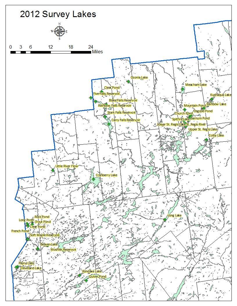
214 209
Cranberry Lake Aquatic Plant Survey 2012
 Cranberry Lake Aquatic Plant Survey 2012 Map 32: Location of Cranberry Lake. Cranberry Lake is located in the town of Clifton in St. Lawrence County, New York (Map 32). The 6995 acre lake was accessed
Ozonia Lake Aquatic Plant Survey 2012
 Aquatic Plant Survey 2012 Map 73: Location of. is located in the town of Hopkinton in St. Lawrence County, NY (Map 73). The 405 acre lake was accessed by a hardtop launch on the northern shore. The launch
APPENDIX B. USGS 7.5 Minute Quadrangles for Chesapeake Bay and the Delmarva Peninsula Coastal Bays
 APPENDIX B USGS 7.5 Minute Quadrangles for Chesapeake Bay and the Delmarva Peninsula Coastal Bays Showing Distribution, Abundance, and Groundtruthing of SAV in 1998 Boundaries of individual SAV beds are
International AIS Conference 2017
 International AIS Conference 2017 Leveraging Partnerships to Implement the Adirondack AIS Prevention Program: A Landscape-Scaled Watercraft Inspection and Decontamination Program October 24, 2017 Eric
Survey of Rodman Reservoir and middle-ocklawaha River springs during spring 2008 draw-down conditions: FWC and FWS
 Survey of Rodman Reservoir and middle-ocklawaha River springs during spring 2008 draw-down conditions: FWC and FWS Date of Survey: February 26, 2008 Survey conducted by: Dawn Jennings, USFWS Nicole Adimey,
CSLAP 2010 Lake Water Quality Summary: Lake George
 CSLAP 2010 Lake Water Quality Summary: Lake George General Lake Information Location Towns of Ticonderoga, Hague, Putnam, Bolton, Dresden, Warrensburg, Fort Ann, Lake George County Washington, Warren,
SeagrassNet Monitoring in Great Bay, New Hampshire, 2016
 University of New Hampshire University of New Hampshire Scholars' Repository PREP Reports & Publications Institute for the Study of Earth, Oceans, and Space (EOS) 9-28-2017 SeagrassNet Monitoring in Great
Minnesota Department of Natural Resources
 Lake Name: Orono Minnesota Department of Natural Resources Fisheries Management DRAFT VERSION - PRELIMINARY DATA Survey Type: Re-Survey DOW Number: 7-- Survey Date: 8/4/8 Lake Identification Alternate
The Appleton Wetland; Its Decline, Cause and Recommended Action. Appendix K: Wetland Inspection
 The Appleton Wetland; Its Decline, Cause and Recommended Action Appendix K: Wetland Inspection Report prepared by Appleton Wetland Research Group of the Mississippi Valley Field Naturalists Research Group
2011 Lake Minnetonka Zebra Mussel Study Summary December 8, 2011
 2011 Lake Minnetonka Zebra Mussel Study Summary December 8, 2011 Zebra mussels were discovered in Lake Minnetonka on July 27, 2010. Quickly, MCWD and the Minnesota Department of Natural Resources (MN DNR)
Lake Trout Population Assessment Wellesley Lake 1997, 2002, 2007
 Lake Trout Population Assessment Wellesley Lake Prepared by: Lars Jessup Fish and Wildlife Branch November 2009 Lake Trout Population Assessment Wellesley Lake Yukon Fish and Wildlife Branch TR-09-01 Acknowledgements
Recreation Opportunity Spectrum for River Management v
 Recreation Opportunity Spectrum for Management v. 120803 Introduction The following Recreation Opportunity Spectrum (ROS) characterizations and matrices mirror the presentation in the ROS Primer and Field
Photopoint Monitoring in the Adirondack Alpine Zone
 Photopoint Monitoring in the Adirondack Alpine Zone Julia Goren (PI) and Seth Jones Adirondack High Peaks Summit Steward Program Adirondack Mountain Club summit@adk.org PO Box 867, Lake Placid, NY 12946
Watershed Stewardship Program
 Watershed Stewardship Program Summary of Programs and Research, 2004 Adirondack Watershed Institute Paul Smith's College Watershed Stewardship Program: Summary of Programs and Research, 2004 2 Table of
Detection of high density of Yellow-bellied gliders at Mt Jersey,
 Detection of high density of Yellow-bellied gliders at Mt Jersey, 07.11.16 Surveyors: Dave Caldwell, Joe Henderson, Ed Hill. Method: A spotlighting and call-playback transect was walked through coupe 891-512-
A catchment approach to Himalayan Balsam control. Chris Jackson
 A catchment approach to Himalayan Balsam control Chris Jackson What are Invasive Non-native Species? Convention of Biological Diversity States that INNS are one of the top threats to international biodiversity
VOLUME II APPENDIX F DETAILED PHYSICAL DESCRIPTION OF PROJECT RESERVOIRS AND LANDS
 VOLUME II APPENDIX F DETAILED PHYSICAL DESCRIPTION OF PROJECT RESERVOIRS AND LANDS THE CENTRAL NEBRASKA PUBLIC POWER AND IRRIGATION DISTRICT FERC PROJECT NO. 1417 PHYSICAL DESCRIPTION OF PROJECT LANDS
Year 10 Mathematics Examination SEMESTER
 STUDENT NAME: TEACHER: DATE: Year 10 Mathematics Examination SEMESTER 2 2016 QUESTION AND ANSWER BOOKLET TIME ALLOWED FOR THIS PAPER Reading time before commencing work: 10 minutes Working time for this
Androscoggin River Trail Access Sites. North Woods. 168 miles from its source at Lake Umbagog to Merrymeeting Bay
 Androscoggin River Trail Access Sites North Woods 168 miles from its source at Lake Umbagog to Merrymeeting Bay Trail Under Construction More than 40 Public Access Sites Available Androscoggin River Watershed
Yellow Bellied Glider (Petaurus australis) detection report Pikes Hill track Webbed Feet coupe
 detection report Pikes Hill track Webbed Feet coupe") geco.media@gmail.com www.geco.org.au Yellow Bellied Glider (Petaurus australis) detection report Pikes Hill track Webbed Feet coupe - 830-507- 0020 Author: Ed Hill (geco.media@gmail.com) Ph: 0414 199 645
geco.media@gmail.com www.geco.org.au Yellow Bellied Glider (Petaurus australis) detection report Pikes Hill track Webbed Feet coupe - 830-507- 0020 Author: Ed Hill (geco.media@gmail.com) Ph: 0414 199 645
CORALFISH 2010 Cruise Report: CF0910-ROV. Eastern Ionian, Cephalonia Island
 CORALFISH 2010 Cruise Report: CF0910-ROV 24 29 th September 2010 Eastern Ionian, Cephalonia Island Dr. Chris Smith & Shipboard Scientific Crew Hellenic Centre for Marine Research CoralFISH: EU Project
Appalachian Power Company Smith Mountain Hydroelectric Project FERC No Debris Management Plan
 Appalachian Power Company Smith Mountain Hydroelectric Project FERC No. 2210 Debris Management Plan Final July2008 TABLE OF CONTENTS Description Page SUMMARY 1 1.0 Introduction.. 2 1.1 Project Lands and
Appendix A: CSLAP 2009 Lake Water Quality Summary: DeRuyter Reservoir
 Appendix A: CSLAP 2009 Lake Water Quality Summary: DeRuyter Reservoir General Lake Information Location County Basin Size Lake Origins Watershed Area Retention Time Mean Depth Sounding Depth Public Access?
SEGMENT ASSESSMENT REPORT
 2017 SEGMENT ASSESSMENT REPORT SEGMENT 3: MT ROSE / TAHOE MEADOWS TO SPOONER SUMMIT REPORT SUMMARY This report is a compilation of information collected on the Tahoe Rim Trail during assessments performed
Lake Baroon RECREATION GUIDE
 Lake Baroon RECREATION GUIDE seqwater.com.au About Lake Baroon OUR VISION To manage access to recreation opportunities while protecting natural resources and water quality. Lake Baroon, located between
Lake Wissota Access Locations within the LaFayette Township. By Chad Martin
 Lake Wissota Access Locations within the LaFayette Township By Chad Martin Anson/ Wissota Access Point # 1 Road: 195 th St. Associated Fire Numbers: 13294 Defining Characteristics: Forested from road
Theme: Predominately natural/natural appearing; rustic improvements to protect resources. Size*: 2,500 + acres Infrastructure**:
 Recreation Opportunity Spectrum (ROS) Classes The Recreation Opportunity Spectrum (ROS) provides a way to describe the variations in the degree of isolation from the sounds and influences of people, and
Form for Project Descriptions - December 2013 version! 1. Stone Valley Cooperative Recreation Area (SVCRA) Project Description
 Project Description") Form for Project Descriptions - December 2013 version 1 Stone Valley Cooperative Recreation Area (SVCRA) Project Description The Stone Valley partners request that proposed work on land within the SVCRA
Form for Project Descriptions - December 2013 version 1 Stone Valley Cooperative Recreation Area (SVCRA) Project Description The Stone Valley partners request that proposed work on land within the SVCRA
STREAMWALKS REVISITED
 STREAMWALKS REVISITED Maggie A. Kendrick, Department of Earth Sciences, University of South Alabama, Mobile, AL, 36688. Email: mak0209@aol.com. The goal of my research is to have a system of streamwalks
Wilderness Research. in Alaska s National Parks. Scientists: Heading to the Alaska Wilderness? Introduction
 Wilderness Research in Alaska s National Parks National Park Service U.S. Department of Interior Scientists: Heading to the Alaska Wilderness? Archeologist conducts fieldwork in Gates of the Arctic National
Remote Sensing into the Study of Ancient Beiting City in North-Western China
 Dingwall, L., S. Exon, V. Gaffney, S. Laflin and M. van Leusen (eds.) 1999. Archaeology in the Age of the Internet. CAA97. Computer Applications and Quantitative Methods in Archaeology. Proceedings of
Cataloochee. Fishing Species Rainbow Trout and Brook Trout. Recreation
 Cataloochee River Information The Cataloochee River is located in the historic Cataloochee Valley--a relatively remote part of Smoky Mountain National Park. The campground is a secluded setting and offers
Header i
 Header i 048285014.10 Header Sub Title Body Text here. Body text here. Body text here. Section 1... 1 Executive Summary... 1 Opportunities and Constraints... 3 Overall Opportunities and Constraints Map
Koala and Greater Glider detection report, Ray s track coupes and , East Gippsland
 Koala and Greater Glider detection report, Ray s track coupes 905-501- 0011 and 905-501- 0010, East Gippsland Surveyors: Rena Gaborov and David Caldwell Report author: Rena Gaborov Report Date: 14/2/17
Lake Acreage Mcleese Lake, BC
 Lake Acreage Mcleese Lake, BC Jason Zroback jason@landquest.com 1 (604) 414-5577 Jamie Zroback jamie@landquest.com 1 (604) 483-1605 The Source for Oceanfront, Lakefront, Islands, Ranches, Resorts & Land
Ocean County Brian Berkowitz (Partner Adam Nassr Monmouth County)
") Ocean County Brian Berkowitz (Partner Adam Nassr Monmouth County) 1. County Summary Ocean County, founded in 1850, is located along the Jersey Shore in the state of New Jersey and has been one of the fastest
Ocean County Brian Berkowitz (Partner Adam Nassr Monmouth County) 1. County Summary Ocean County, founded in 1850, is located along the Jersey Shore in the state of New Jersey and has been one of the fastest
RECREATION. Seven issues were identified that pertain to the effects of travel management on outdoor recreation within portions of the project area.
 RECREATION Seven issues were identified that pertain to the effects of travel management on outdoor recreation within portions of the project area. OPPORTUNITIES FOR SOLITUDE / QUIET TRAILS. One attraction
CSLAP 2014 Lake Water Quality Summary: DeRuyter Reservoir
 General Lake Information CSLAP 2014 Lake Water Quality Summary: DeRuyter Reservoir Location Town of DeRuyter County Madison Basin Seneca/Oneida/Oswego Rivers Size 225.3 hectares (556.5 acres) Lake Origins
EDGEWILD TRAIL Non Motorized Trail PROPOSED DEVELOPMENT PROJECT
 EDGEWILD TRAIL Non Motorized Trail PROPOSED DEVELOPMENT PROJECT SESW, SWSE Section 15, NWNE, NENW, SWNE, SENE Section 22, Township 138, Range 27 (City of Fifty Lakes) Crow Wing County Land Services Department
B HALL RANCH FISHTAIL, MONTANA
 Brochure Courtesy of: B HALL RANCH FISHTAIL, MONTANA w w w. m c c a s l i n l a n d. c o m Page 1 LOCATION The Hall Ranch is ideally located in the foothills of the Beartooth Mountains, approximately 5
Magnetic Island Summary Report 2018
 Reef Check Australia Magnetic Island Summary Report Reef Check Foundation Ltd. (Australia) www.reefcheckaustralia.org This report should be cited as: J. Loder and G. Molinaro (). Reef Check Australia Magnetic
INTRODUCTION 250,000
 INTRODUCTION The United States of America has over 250,000 rivers, with a total of about 3,500,000 miles of rivers. The main stems of 38 rivers in the United States are at least 500 miles (800 km) long.
Understanding user expectations And planning for long term sustainability 1
 Understanding user expectations And planning for long term sustainability 1 What is a natural surface trail? It can be as simple has a mineral soil, mulched or graveled pathway, or as developed as elevated
SECTION 3 GENERAL DESCRIPTION OF THE RIVER BASIN
 SECTION 3 GENERAL DESCRIPTION OF THE RIVER BASIN SECTION 3 GENERAL DESCRIPTION OF THE RIVER BASIN River basin description. A general description of the river basin or subbasin, as appropriate, in which
DIDYMO SURVEY, LOWER FRYINGPAN RIVER, BASALT, COLORADO 2015
 DIDYMO SURVEY, LOWER FRYINGPAN RIVER, BASALT, COLORADO 2015 Second Annual Report PREPARED FOR: ROARING FORK CONSERVANCY PREPARED BY: COLORADO MOUNTAIN COLLEGE NATURAL RESOURCE MANAGEMENT PROGRAM TIMBERLINE
Rock Creek State Park
 Rock Creek State Park Rock Creek State Park Rock Creek State Park, located five miles west of Grinnell, consists of a large man-made lake and a surrounding fringe of land. There are several access points
Flag #147 Expedition
 Flag #147 Expedition The Continuation of A Photographic Survey of the Living Mollusks In The Coastal Honduran Region Including The Utila Cays with Emphasis On Two Subspecies of Volutes and Murex Rawlings,
On The Boreas Ponds Acquisition
 On The Boreas Ponds Acquisition by David Gibson, Adirondack Almanack SUNDAY, APRIL 17, 2016 Boreas Ponds looking towards the High Peaks Wilderness. Photo c Dave Gibson My first reaction to the announcement
CSLAP 2012 Lake Water Quality Summary: DeRuyter Reservoir
 CSLAP 2012 Lake Water Quality Summary: DeRuyter Reservoir General Lake Information Location Town of DeRuyter County Madison Basin Seneca/Oneida/Oswego Rivers Size 225.3 hectares (556.5 acres) Lake Origins
Trail Number Conversion List
 Trail Number Conversion List National Geographic has begun work on new editions of Trails Illustrated Maps 745 and 746, which they hope to release in late 2018. Because the trail numbers of the current
ANAGEMENT. LAN November, 1996
 M ANAGEMENT P LAN November, 1996 for Paul Lake Provincial Park Ministry of Environment, Lands and Parks BC Parks Department Paul Lake Provincial Park M ANAGEMENT P LAN Prepared by BC Parks Kamloops Area
Arrowhead Ranch. Located in the Big Range Country of Central Wyoming.
 Arrowhead Ranch Located in the Big Range Country of Central Wyoming. 58 E. Benteen Street Buffalo, WY 82834 Ph 307-684-9556 Toll Free 888-684-9557 Fax 307-684-8565 Location The ranch is approximately:
Environment and Natural Resources Trust Fund 2017 Request for Proposals (RFP)
") Project Title: Total Project Budget: $ Environment and Natural Resources Trust Fund 2017 Request for Proposals (RFP) Floating Classroom: Connecting 20,000 Youth to Minnesota Waterways Category: Proposed
Project Title: Total Project Budget: $ Environment and Natural Resources Trust Fund 2017 Request for Proposals (RFP) Floating Classroom: Connecting 20,000 Youth to Minnesota Waterways Category: Proposed
Non-motorized Trail Plan & Proposal. August 8, 2014
 Town of Star Valley Ranch, Wyoming and the Star Valley Ranch Association in partnership with the USDA Forest Service, Bridger-Teton National Forest, Greys River Ranger District Non-motorized Trail Plan
Request for Proposal National Tropical Botanical Garden Lower Limahuli Preserve Emergency Stream Debris Removal
 Request for Proposal National Tropical Botanical Garden Lower Limahuli Preserve Emergency Stream Debris Removal I. Summary of Work Bids are solicited for the emergency removal of debris deposited in the
Minnesota Department of Natural Resources
 Minnesota Department of Natural Resources Fisheries Management DRAFT VERSION - PRELIMINARY DATA (AS OF 6/2/2) Lake Name: Yankton Survey Type: Population Assessment DOW Number: 2-7- Survey ID Date: 6/6/2
DIXIE HIGHWAY Region of Peel NAI Area # 1304, 1320, 2449, 2625, 3961
 DIXIE HIGHWAY 407 1 Region of Peel NAI Area # 1304, 1320, 2449, 2625, 3961 Toronto and Region Conservation Authority City of Brampton Size: 36 hectares Watershed: Etobicoke Creek Con 4 E, Lots 13, 14 Ownership:
Minnesota Department of Natural Resources
 Minnesota Department of Natural Resources Fisheries Management VERSION - PRELIMINARY DATA (AS OF 7/6/25) Lake Name: Imogene Survey Type: Standard Survey DOW Number: 46-2- Survey ID Date: 7/3/25 Lake Identification
Treaty Oaks Ranch 323+/- Acres Hood County, Texas $1,776,500
 Bret Polk Mobile: (254) 965-0349 Office: (214) 361-9191 Treaty Oaks Ranch 323+/- Acres Hood County, Texas $1,776,500 LOCATION: The ranch is located in a desirable area 10+/- miles south of Granbury, Texas,
Recreation Guide. Adirondacks & Tug Hill. Toll Free: Web Site:
 Adirondacks & Tug Hill Outdoor Recreation Guide Toll Free: 1-800-724-0242 Web Site: www.lewiscountychamber.org www.adirondackstughill.com I LOVE NEW YORK logo is a registered trademark/service mark of
The Trusts Dredging Strategy
 NAG Meeting 21st September 2012 Graham Holland Head of Asset Management Current Review Why Now? Previous practices not always well defined Processes required greater clarity The need to apply asset management
Appendix 1: Best Management Practices For Hang Gliding and Paragliding in Jasper National Parks
 Appendix 1: Best Management Practices For Hang Gliding and Paragliding in Jasper National Parks Name of Best Management Practice Best Management Practices for Hang Gliding and Paragliding in Jasper National
United States Department of the Interior National Park Service. Boundary Expansion Listed in National Register January 11, 2017
 NPS Form 10900-a (Rev. 8/2002) OMB No. 10240018 United States Department of the Interior National Park Service Boundary Expansion Listed in National Register January 11, 2017 National Register of Historic
R. Weller December 10, 2014 Version 1.3
 1 R. Weller December 10, 2014 Version 1.3 Cruise Plan First deployment of 55 S, 90 W Global Node, RV Atlantis AT26-29, Punta Arenas, Chile February 12, 2015 to Punta Arenas, Chile March 5, 2015 Overview
East Branch Medway River Route 21
 East Branch River Route 2 This route is NOT recommended for NOVICE and INTERMEDIATE paddlers The route is comprised of the East Branch of the River, the River proper, and Port. Although there are a number
This Passport: Revised October 20, 2017, EAM # Discovering the Trails of Penfield, NY
 This Passport: Revised October 20, 2017, EAM #161922 Discovering the Trails of Penfield, NY The Town of Penfield is fortunate to have a wide variety of natural resources which make for many unique and
R E SEARCH HIGHLIGHTS
 Canada Research Chair in Urban Change and Adaptation R E SEARCH HIGHLIGHTS Research Highlight No. 12 June 2007 LOCATION OF PANHANDLING ACTIVITY IN WINNIPEG Introduction Panhandling activity in Winnipeg
NORTHWEST SECTION CONTENTS: CLEVELAND PARK FOLWELL PARK RYAN LAKE PARK VICTORY PRAIRIE DOG PARK VICTORY PARK
 NORTHWEST SECTION CONTENTS: CLEVELAND PARK FOLWELL PARK RYAN LAKE PARK VICTORY PRAIRIE DOG PARK VICTORY PARK LUCY LANEY COMMUNITY SCHOOL N 33RD AVE N 33RD AVE SINGLE-FAMILY RESIDENTIAL MULTI-USE DIAMOND
291-ACRE WATSONVILLE MUNICIPAL AIRPORT STUDY AREA
 THIRD ANNUAL SANTA CRUZ TARPLANT POPULATION ASSESSMENT FOR THE 291-ACRE WATSONVILLE MUNICIPAL AIRPORT STUDY AREA CITY OF WATSONVILLE, SANTA CRUZ COUNTY, CALIFORNIA Prepared for: CITY OF WATSONVILLE, WATSONVILLE
Minnesota Department of Natural Resources
 Minnesota Department of Natural Resources Fisheries Management LAKE SURVEY REPORT DRAFT VERSION - PRELIMINARY DATA (AS OF /4/2) Lake Name: Talcot Survey Type: Standard Survey DOW Number: -- Survey ID Date:
Duncan Hastie, P.E. Dewberry
 FEMA s Riverine High Water Marks for Atlanta s September 2009 Flood Event Duncan Hastie, P.E. Dewberry Background High Water Mark Recovery Performed Through FEMA s Hazard Mitigation Technical Assistance
CONGESTION MONITORING THE NEW ZEALAND EXPERIENCE. By Mike Curran, Manager Strategic Policy, Transit New Zealand
 CONGESTION MONITORING THE NEW ZEALAND EXPERIENCE 26 th Australasian Transport Research Forum Wellington New Zealand 1-3 October 2003 By, Manager Strategic Policy, Transit New Zealand Abstract New Zealand
Access: The rocky shoreline is only accessible via private property.
 10. Whale Cove Site description: Whale Cove is a small cove fringed by private homes and condominiums with diverse and relatively undisturbed rocky intertidal and subtidal habitat located approximately
Tufts University Water: Systems, Science, and Society (WSSS) Program
 Program") To: From: John Foster, Elbow Cay, the Bahamas; Friends of the Environment, Marsh Harbor, the Bahamas Alex Bedig, Amanda Garfield, Shonda Gaylord, Jack Melcher, Melissa Ng, Nathan Rawding, Kendall Webster,
To: From: John Foster, Elbow Cay, the Bahamas; Friends of the Environment, Marsh Harbor, the Bahamas Alex Bedig, Amanda Garfield, Shonda Gaylord, Jack Melcher, Melissa Ng, Nathan Rawding, Kendall Webster,
Twelve Apostles Marine National Park Australia
 EVALUATION REPORT Twelve Apostles Marine National Park Australia Location: Victoria, Australia coastal waters Global Ocean Refuge Status: Nominated (2017), Evaluated (2017) MPAtlas.org ID: 7703885 Manager(s):
GO Rowing! 2016 End of the Season Issue. Grateful Oars Rowing Club, Norwood, NY. Annual Meeting October 18 at the Lobster House, 6 PM
 GO Rowing! 2016 End of the Season Issue Grateful Oars Rowing Club, Norwood, NY Annual Meeting October 18 at the Lobster House, 6 PM Gwen s Message Gwen Cunningham, President I'm looking forward to and
AMERICAN S PARTICIPATION IN OUTDOOR RECREATION: Results From NSRE 2000 (With weighted data) (Round 1)
 (Round 1)") AMERICAN S PARTICIPATION IN OUTDOOR RECREATION: Results From NSRE 2000 (With weighted data) (Round 1) The emphasis of this report is on participation patterns across activities and segments of our society.
AMERICAN S PARTICIPATION IN OUTDOOR RECREATION: Results From NSRE 2000 (With weighted data) (Round 1) The emphasis of this report is on participation patterns across activities and segments of our society.
REPORT ON THE DEPLOYMENT OF RAPID-WAVE B. O. CORNIDE DE SAAVEDRA RADPROF0910 CRUISE 2010 VIGO-SANTANDER, 30 AUGUST-1 SEPTEMBER 2010
 REPORT ON THE DEPLOYMENT OF RAPID-WAVE MOORINGS OFF CABO MAYOR AND CABO FINISTERRE: RAPIDO B. O. CORNIDE DE SAAVEDRA RADPROF0910 CRUISE 2010 VIGO-SANTANDER, 30 AUGUST-1 SEPTEMBER 2010 MIGUEL ÁNGEL MORALES
CITY OF LYNDEN STORMWATER MANAGEMENT PROGRAM REPORT MARCH 1, 2016
 CITY OF LYNDEN STORMWATER MANAGEMENT PROGRAM 2015 WATER QUALITY MONITORING REPORT CITY OF LYNDEN 300 4 TH STREET LYNDEN, WASHINGTON 98264 PHONE (360) 354-3446 MARCH 1, 2016 This document serves as an attachment
The History of a Floodplain Meadow Bridget Smith
 The History of a Floodplain Meadow Bridget Smith I have lived in the village of Hemingford Grey near the River Great Ouse since 1976 and, like many others, walked the 1½ km into St Ives by the ancient
The combined Planning and Zoning and Council Meeting was called to order at 7:00 p.m.
 Lake Remediation Master Plan The combined Planning and Zoning and Council Meeting was called to order at 7:00 p.m. Roll Call: Councilman Joe Curl, Councilwoman Tiffany Hughes, Councilwoman Lori Howard,
B10. Agate Beach State Recreation Site
 B10. Agate Beach State Recreation Site Location Within the City of Newport, just south of the Yaquina Head Outstanding Natural Area. The park is located along the west side of Highway 101 at the mouth
Dr. Melissa Grigione And Kurt Menke. Jaguar -Arturo. Jaguarundi -Arturo. Ocelot -Arturo. Caso. Caso. Caso
 Identifying Priority Conservation Areas in the U.S.- Mexico Border Region for America s Neotropical Cats, the Jaguar, Jaguarundi and Ocelot: An International Effort Dr. Melissa Grigione And Kurt Menke
South Lake Union History Trail
 South Lake Union History Trail Seattle Starts Here: Welcome to the History Trail Travel through 150 years of history, from wilderness to world city, right at the water s edge and the city s heart. Explore
Real-time route planning streamlines onboard operations, reduces fuel burn and delays, and improves on-time performance.
 Real-time route planning streamlines onboard operations, reduces fuel burn and delays, and improves on-time performance. Operational Efficiency of Dynamic Navigation Charting Benefits such as improved
Stephens State Park Trails
 TRAILS OF ALLAMUCHY MOUNTAIN & STEPHENS STATE PARKS Allamuchy Mountain and Stephens State Parks contain 28 marked trails providing access to diverse landscapes for walking, hiking, biking, bird-watching,
Camp Jack Wright PERMANENT ORIENTEERING COURSE (2004)
") Camp Jack Wright PERMANENT ORIENTEERING COURSE (2004) WHAT IS ORIENTEERING? The skill which enables a person to navigate with a map. In the competitive sport, the winner is the person who finishes in the
Camp Jack Wright PERMANENT ORIENTEERING COURSE (2004) WHAT IS ORIENTEERING? The skill which enables a person to navigate with a map. In the competitive sport, the winner is the person who finishes in the
Canberra Airport Aircraft Noise Information Report
 Canberra Airport Aircraft Noise Information Report Quarter 4 2015 (October to December) 1 Version Control Version Number Detail Prepared by Date 1 - Environment March 2016 Airservices Australia. All rights
Northeast Quadrant Distinctive Features
 NORTHEAST QUADRANT Northeast Quadrant Distinctive Features LAND USE The Northeast Quadrant includes all the area within the planning area that is east of Interstate 5 and to the north of State Route 44.
Wildlife Management from a Regulatory Perspective
 Wildlife Management from a Regulatory Perspective Description Operators of aircraft have a reasonable expectation that any wildlife hazard which may exist at an airport they use will be managed to a level
Wapogasset/Bear Trap Lake Improvement Association Meeting. August 12, 2017 (Updated 9/8/17)
") Wapogasset/Bear Trap Lake Improvement Association Meeting Meeting Called to order at 8:30 a.m. Welcome and introduction of guests August 12, 2017 (Updated 9/8/17) Guest Speaker Amery Fire Department Representatives
Wapogasset/Bear Trap Lake Improvement Association Meeting Meeting Called to order at 8:30 a.m. Welcome and introduction of guests August 12, 2017 (Updated 9/8/17) Guest Speaker Amery Fire Department Representatives
Cooper-Hewitt, National Design Museum Visitors Summer 2008 Summary of Findings
 Introduction Cooper-Hewitt, National Design Museum Visitors Summer 2008 Summary of Findings Office of Policy & Analysis Smithsonian Institution July 2008 In June 2008, the Office of Policy and Analysis
USDA TRAILS STRATEGY PROGRAM
 USDA TRAILS STRATEGY PROGRAM WRPI Program: English Peak Survey Jorge D. Briceño Southwestern Community College Internship Time Period: June 6, 2016 August 8, 2016 Advisor: Sam Commarto Recreation Officer
GOOSENECK SWAMP INFORMATION DAY - Saturday 14 th December 2013
 GOOSENECK SWAMP INFORMATION DAY - Saturday 14 th December 2013 Progress of a restoration trial at Gooseneck Swamp - Grampians National Park, Victoria Gooseneck Swamp is situated at the far south-eastern
APPENDIX F List of Commitments
 APPENDIX F List of Commitments s Table F.1 Standard Mitigation Measures Mitigation Measure MnDOT Specification Number Status Update Description Status Update Utilities Provide early notice to utility operators
Minnesota Department of Natural Resources
 Minnesota Department of Natural Resources Fisheries Management LAKE SURVEY REPORT DRAFT VERSION - PRELIMINARY DATA (AS OF 7//26) Lake Name: Loon Survey Type: Standard Survey DOW Number: 32-2- Survey ID
LAKE SURVEY REPORT DRAFT VERSION PRELIMINARY DATA (AS OF 07/24/2018) Fisheries Management. DOW Number: Survey ID Date: 07/16/2018
 Fisheries Management. DOW Number: Survey ID Date: 07/16/2018") Fisheries Management LAKE SURVEY REPORT DRAFT VERSION PRELIMINARY DATA (AS OF 7/2/2) Lake Name: Long Survey Type: Standard Survey DOW Number: 3-- Survey ID Date: 7/6/2 Lake Identification Alternate Lake
Fisheries Management LAKE SURVEY REPORT DRAFT VERSION PRELIMINARY DATA (AS OF 7/2/2) Lake Name: Long Survey Type: Standard Survey DOW Number: 3-- Survey ID Date: 7/6/2 Lake Identification Alternate Lake
The Holes Creek Bridge Replacement By Bradley McClelland
 The Holes Creek Bridge Replacement By Bradley McClelland Each time there is a heavy rainstorm, the folks along Sheffield Road in the Dayton, Ohio suburb of West Carrollton have cause to be concerned. Holes
Aquatic Invasive Species Sign Manual
 Aquatic Invasive Species Sign Manual July 2017 Minnesota Department of Natural Resources Ecological and Water Resources Division s Invasive Species Program in cooperation with the Parks and Trails Division
PRESENTATION TO THE RICHMOND REGIONAL TRANSPORTATION PLANNING ORGANIZATION: JUNE 2, 2016 BRT CONNECTIVITY AND LAND USE ANALYSIS PLAN JOSH MALLOW
 Richmond Regional Planning District Commission 1969 PRESENTATION TO THE RICHMOND REGIONAL TRANSPORTATION PLANNING ORGANIZATION: JUNE 2, 2016 BRT CONNECTIVITY AND LAND USE ANALYSIS PLAN JOSH MALLOW PROJECT