Updated - April Where, when, and how to discover the best photography in America. Published since The Chesapeake Bay
|
|
|
- Phebe West
- 5 years ago
- Views:
Transcription


1 Updated - April Where, when, and how to discover the best photography in America Published since 1989 The Chesapeake Bay Every time I fly over the state of Maryland, I am fascinated by all the waterways snaking across the landscape. Maryland s Eastern Shore is deeply scalloped with bays and inlets, rivers and coves. No highway follows the water s edge down the coast. To explore a fishing village on the tip of a small peninsula, you must drive all the way out to that point. My maps of the Chesapeake Bay show many small coastal islands, each at the end of a long, narrow road. My plan for this newsletter was to drive every one of these roads to discover and explore what lay at the end. I would photograph everything interesting I saw. Looking closer, my map of the Eastern Shore revealed a wealth of wildlife refuges, some of my favorite places for photography.

2 issue 68 - page 2 Itraveled the Eastern Shore of the Chesapeake Bay, so I started my explorations from the northern end. I left Interstate 95 at Exit 100, just south of the Pennsylvania border, and drove south ten miles to Elk Neck State Park. This 2,100-acre park is located on the tip of a peninsula formed by the Chesapeake Bay and the Elk River. Elk Neck State Park After entering the state park, the road passes through a small residential community then ends at a gravel parking area. I parked at the end of the road and headed south along the easy two-mile trail out to the tip of Turkey Point. The trail follows the edge of vertical, hundred-foot cliffs above Chesapeake Bay. The wide trail winds through woods and across open meadows where I spotted and photographed several wild turkeys. Rabbits darted across the trail much faster than I could follow with a camera. I turned left at the fork a half-mile south of the parking area. After passing through a wooded area, I reached the Turkey Point Light House at the end of the peninsula. The 35-foot light tower was built here in 1833 atop hundred-foot cliffs at the junction of the Elk River and the Chesapeake Bay. I recommend, if you make this hike, arrive as early in the morning as possible. This would be a wonderful spot to watch the sun rising over the Chesapeake Bay. Turkey Point is an excellent place to photograph soaring hawks, golden eagles, falcons and egrets. You ll see ospreys migrating south in mid-september, members of the hawk family migrating in late October, and golden and bald eagles heading south in early November. Leaving the lighthouse, I walked around the tower, headed west along the cliffs, then followed the trail back into the woods and to the fork where I headed left and returned to the parking area. I was ready for lunch, so I headed back up the peninsula to a place called North East, a small town that has a lot of character. After a great lunch, I returned to Elk Neck and hiked the one-mile Green Trail from the visitor center to the Bohemia Campground. The trail winds through a deep hardwood forest and passes a freshwater pond. The dogwoods were just beginning to bloom. It was getting dark so I headed back on the road. Leaving Elk Neck State Park, I drove fourteen miles north to the town of Elkton where I stayed the night. There are no bridges or ferries across the Elk River. In the morning, I headed south on Route 213, crossed the Bohemia and the Sassafras Rivers and jogged to the right at the town of Galena. I stayed on Route 213 all the way to the old city of Chesterton, well known for its shipbuilding industry. From High Street, the main street of Chesterton, I drove one block south to Cannon Street and headed east to the river. The narrow streets of Chesterton are lined with beautifully-restored homes dating back to colonial times. The old shipyards are now a modern marina, with several historic vessels on display at the docks. A beautiful reproduction of the schooner, Sultana, dating back to 1767, was tied to the end of the pier. From Chesterton, I drove ten miles west on Route 20, stopping in the small town of Rock Hall for lunch. From Rock Hall, it s five miles south to a bridge over the Eastern Neck Narrows between Eastern Neck Island and the Eastern Neck Peninsula. Eastern Neck National Wildlife Refuge Located at the mouth of the Chester River in Kent County, Maryland, Eastern Neck
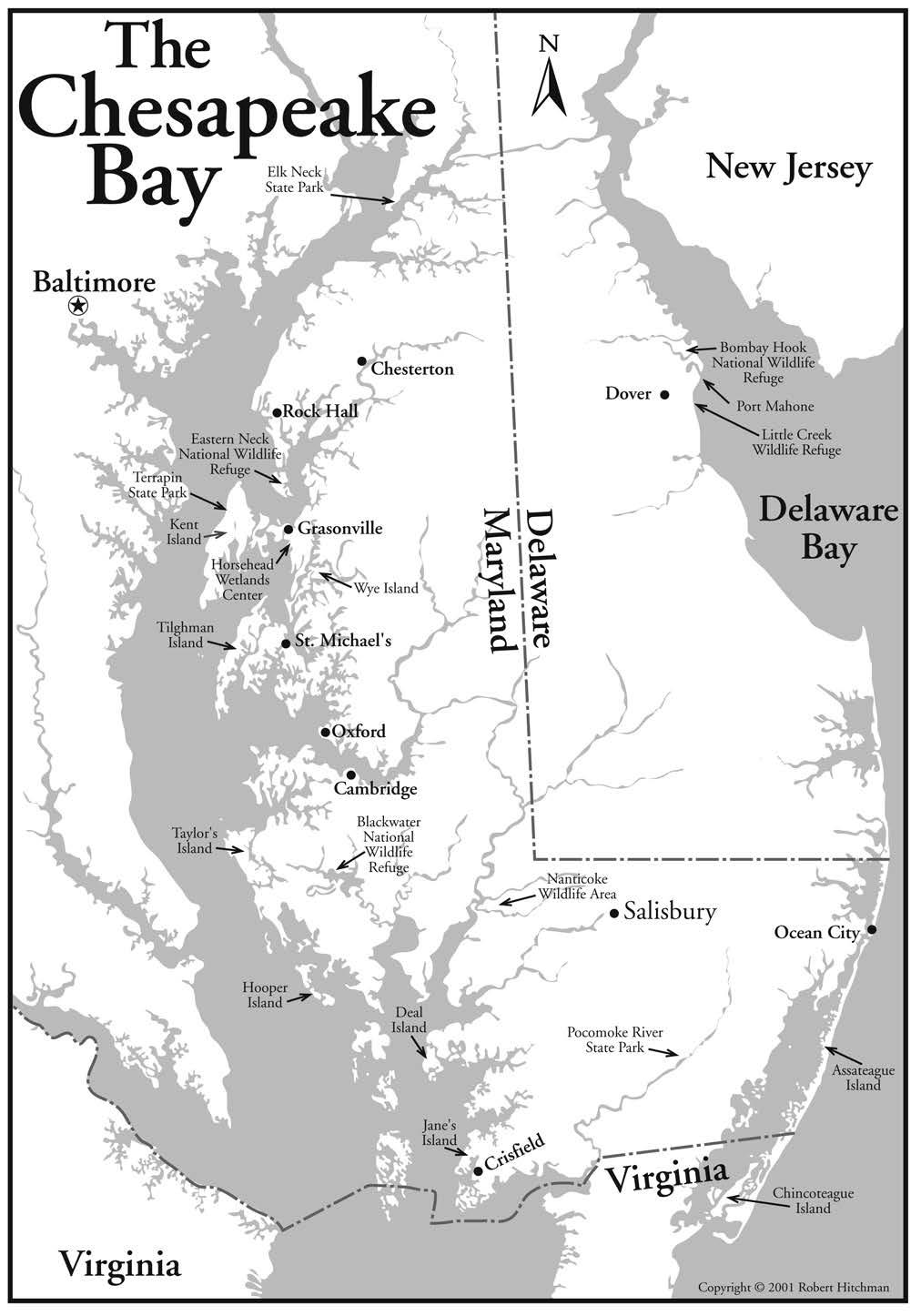
3

4 issue 68 - page 4 Pond on Eastern Neck Refuge Many of the roads through the low country along the Eastern Shore of Chesapeake Bay are two-lane blacktop with no shoulders but deep drainage ditches on both sides. It is sometimes difficult to find a wide spot where you can safely pull off the road for a photograph. Island is out at the tip of a long peninsula bordered by the Chester River and Chesapeake Bay. There are no private residences or commercial establishments on Eastern Neck Island. This 2,285-acre island refuge, established in 1962, is a major feeding and resting place for migratory and wintering waterfowl on Maryland s Eastern Shore. Over 244 species of birds have been observed in Eastern Neck Refuge. Just over the bridge, there s a wide place to park. From the bridge, I photographed the reed-lined waterway under the bridge and a large, white swan on the river. There are two observation towers where you can set up a tripod in the pines on the edge of Tubby Cove. It s a quarter-mile walk from the parking area on a wooden boardwalk. A right turn on the road down the island will take you to the refuge headquarters and bookstore. There, you ll get the information you ll need about locations of waterfowl in the refuge. A short trail from the visitor center leads out to the edge of Chesapeake Bay, then jogs north to a large pond lined with tall chestnut trees. The other four maintained wildlife trails in this refuge cover six miles. All of them lead from the paved access road out to the wetlands along the shore of the island. During my half-day on Eastern Neck Island, I saw three red foxes, six swans, and photographed countless ducks and geese. The main paved road, Route 445 on Eastern Neck Island, ends just beyond the site of one of the first homes in the New World. Major Joseph Wykes built Wickliffe here in To the south, I could see Kent Island and the Chesapeake Bay Bridge, only a few miles away. It took me over an hour to drive there, the long way around, going back through Chesterton, then south through Centreville before reaching Grasonville, where I spent the night. Kent Island Horsehead Wetlands Center South of the Eastern Neck Refuge, three miles across the mouth of the Chester River, lies Kent Island. This is one of the narrowest spots in the Chesapeake Bay and this is where the four-mile-long Chesapeake Bay Bridge was built. Kent Island is the largest island in Chesapeake Bay. Much of Kent Island is dotted with marinas and is covered with farmlands and residential communities. The best reason to visit Kent Island is the five-hundred acre wildlife sanctuary known as the Horsehead Wetlands Center. Operated by the Wildfowl Trust of North America, a private, non-profit conservation organization, this sanctuary educates visitors on the value of wetlands as well as the birds. The sanctuary is on the east side of Prospect Bay, on the east side of Kent Island. To reach the sanctuary, leave Highway 50 at Exit 43B just west of Grasonville, drive east on Route 18 a few blocks, and turn right on Perry s Corner Road. Go a halfmile south to the Horsehead Wetlands Center entrance on the right. Drive out through the woods and follow the road across the marshy grasslands to the parking area. Check in at the visitor center to pick up a trail map and pay the entry fee. In the visitor center, a large window faces a pond that is usually filled with a variety of waterfowl. Check out all the educational displays in the center or just pay the fee, pick up a map, go outside, and start shooting.

5 issue 68 - page 5 I returned to the far end of the parking lot and found the marked trail leading to several observation towers. The first tower overlooks Marshy Creek. From the top, I photographed herons and egrets wading through the reeds along the shore. The trail continues northward, circling a large pond. There are two enclosed blinds, one on each end of this pond labeled Lake Knapp on their map. The blinds have stools installed below small openings facing the pond. From the blind on the west side of the pond named the White Blind for its donor, a Mrs. J.C. White I photographed ducks landing on the pond and frightening the herons each time they splashed down. I photographed a bald eagle and several ospreys circling the pond. The late afternoon sun was behind me and illuminating the scene with fairly flat light. On the trail map, the other blind across the pond was called the East Blind. A good choice for morning photography on Lake Knapp. At the visitor center is a series of small ponds, filled with Chesapeake Bay birds and resting migratory birds on their way to the Arctic. Visitors can walk around the low fences and photograph a great variety of birds. There are large cages where injured and rehabilitating raptors are kept. I photographed a bald eagle, a Cooper s hawk, and several owls through the wire screen. Visitors can walk through a very large, enclosed aviary, covered with a huge net. This is the home of a great variety of colorful ducks. This is a great place to find wildflowers in the spring and migrating monarch butterflies heading south to Mexico in the autumn. Several wild turkeys wander the trails, accustomed to the visitors. Terrapin Beach State Park The caretaker at Horsehead Wetlands Center told me about another, much smaller wildlife area on Kent Island, called Terrapin Beach State Park. On the edge of Chesapeake Bay, I found a one-mile trail, a small pond, and two observation towers for bird watchers and photographers. A boardwalk leads out to the edge of the bay. Heading east or west on US Highway 50, take Exit 37 at the east end of the Chesapeake Bay Bridge and head north on Route 18. Take the first left into the Chesapeake Bay Business Park, drive straight through the first intersection, head left at the second, and drive to the entrance sign. When you start down the trail, bear left onto the narrower trail toward the pond. Wye Island There are some worthwhile trails to explore on Wye Island, just east of Kent Island. Most of this eight-mile-long island is managed by the Maryland Department of Natural Resources Forest and Park Service. On the island, a thirty-acre forest, called School House Woods, is dense with ancient hardwoods that were here when our nation was formed. These mature oaks, hickories, and black gums are a rare sight on the Eastern Shore. The rest of the island is mostly planted with corn and soybean fields, making great cover for wildlife. Four miles east of Grasonville on Highway 50, turn south onto Carmichael Road and drive south five miles where you ll cross the low bridge over the Wye River. When you reach the end of the paved road, keep going. All the trailheads are located farther south, along the gravel road. There are six miles of trails open to the public on Wye Island. Drive to the far end of the island, park at a trailhead, and hike to the old Ferry Point Landing on the river. On the nest


6 issue 68 - page 6 Skipjack at the museum Detail of old schooner at the museum Park anywhere along the long, straight roads on the island and look back up the tunnel of tall hardwoods lining both sides of the country lanes. This island is well known for its busy hunting season. Photographers should avoid Wye Island in the late fall and winter and also beware of the ticks in the tall grass along the trails and use a good tick repellent. Heading South Highway 50 is the main route from the Chesapeake Bay Bridge south to Salisbury, Maryland. It then turns east to Ocean City on the Atlantic side of Maryland. At Easton, twelve miles south of Wye Mills, I left Highway 50 and headed west on Route 33 to St. Michaels, a harbor town on the Miles River. St. Michaels Route 33 goes down the main street of St. Michaels. You can t get lost although the street signs are very small. Watch carefully for the sign at the corner of Mill Street for the right turn into the Chesapeake Bay Maritime Museum. Drive to the end of the street, park in the lot and walk across the street to the entrance on the bay. This is a great place to soak up the history of the Eastern Shore of Maryland. There are more than eighty-five antique and restored sailing vessels on display. Many are floating, tied to the docks surrounding the museum s grounds. There are examples of classic power boats and twin-masted schooners. When the old Hooper Strait Lighthouse was deactivated, it was saved from demolition, removed from its old position in Chesapeake Bay a few miles south, and installed here on the museum grounds. Visitors can climb the ladders to explore the authentically-furnished lighthousekeepers quarters and then climb the circular stairwell to the top of the tower for close-up photographs of the fresnel lens. The outside deck around the top of the light tower offers a great panoramic view of the bay, the boats below, and the town of St. Michaels. I especially enjoy photographing the reflected patterns of small, colorful boats on the rippled surface of water. With a 200mm telephoto, I was able to frame tight compositions of weathered rigging and many other details of authentic working oyster boats and the famous Chesapeake Bay skipjacks. A few of these sail-powered boats are still in use on the bay for oyster dredging. I arrived at the Maritime Museum just after the gates opened at 9 am and stayed most of the day. Guided tours are available or you can wander freely. Tilghman Island After leaving the Chesapeake Bay Maritime Museum, I drove west on Route 33 toward Tilghman Island. I missed the opening of the drawbridge, so I crossed the Knapps Narrows and drove to the far end of the narrow island. There were a couple of working boats in Dogwood Harbor, but this island is mostly a retirement community with lots of yachts.


7 issue 68 - page 7 A check of the map showed that the next place I had to visit was another peninsula a short distance down the coast, but a long way around by road. I followed Route 579 out to the small village of Neavitt on the coast. There was a small fleet of working boats in the harbor at the end of Long Point Road. I found some great harbor scenes and lots of details from dockside. I drove back through St. Michaels and headed west on Route 33, watching for the right turn onto Route 329 and the Ferry Neck Road. This route to the small community of Bellevue saved many miles of driving. I was able to cross the Tred Avon River on a small nine-car ferry that runs between the small communities of Bellevue and Oxford, Maryland. (from March to December 15). It is the nation s oldest continuously-operating ferry. It was started in 1683, was out of service during the American Revolution until 1836, and has been making its ten-minute run across the Tred Avon River ever since. After driving off the ferry in Oxford, I parked near the harbor and found a spot on the shore, beneath the trees, to photograph the ferry leaving the dock. After leaving Oxford, I headed southeast to the city of Salisbury, the largest city in southern Maryland. Salisbury is located half-way between the Blackwater National Wildlife Refuge and the Assateaque National Seashore and is a convenient, central location for explorations of all of southern Maryland. I found a large selection of lodgings and plenty of good restaurants. Nanticoke Wildlife Management Area After a few days of rain, the parking lot at the Nanticoke refuge was a quagmire. The trail wasn t much better. It led out across a marshy peninsula to the edge of Quantico Creek which flows into the Nanticoke River. I photographed herons, egrets, osprey, and several bald eagles from a blind I fashioned by sitting on the ground in the middle of a large bunch of tall reeds. My dark green parka blended into the landscape. I stayed very still for twenty minutes before I saw any action. When a great blue heron waded close enough to fill my viewfinder, I knew I was doing something right. A 400mm telephoto was all I needed in the Nanticoke Wildlife Management Area. Bellevue/Oxford Ferry Canada Goose at Blackwater Refuge

8 issue 68 - page 8 Nanticoke is ten miles west of the city of Salisbury, Maryland. The drive seems a lot farther and more round-about. Six miles northwest of Salisbury on Highway 50, watch for the left turn onto Route 347 through the village of Hebron. Follow this road five miles southwest until it veers to the left at Quantico. In that village, turn right at the first street, marked Cherry Walk, and continue west for another two miles. The sign at the left turn onto Nutters Neck Road points the way to the Nanticoke Wildlife Management Area. Skipjacks on Deal Island Blackwater National Wildlife Refuge Visit Blackwater National Wildlife any time you are cruising the Eastern Shore of Maryland. This place, located fifteen miles west of Nanticoke and eight miles south of Cambridge, Maryland, is beautiful. You will hear the birds as you approach the refuge on Key Wallace Drive. Geese, ducks, and swans are honking and quacking and the song birds are singing. The very wide but shallow Blackwater River is covered with migratory waterfowl in the autumn and again in the spring. The marshes are spotted with wading birds. The dead trees and branches are filled with bald eagles, hawks, and vultures. There are over thirty osprey nests atop poles placed around the Blackwater Refuge and every one I saw was still occupied in mid-april. Heading south of Cambridge on Route 16, watch for the sign at the south end of the village called Church Creek, pointing out the left turn onto Route 335. Drive four miles south. Make a left at the next sign at the left turn onto Key Wallace Road, encircling the northern side of the refuge. First, you ll see the visitor center and then the right turn onto Wildlife Drive, a six-and-a-half mile road that leads out to the trailhead at the Marsh Edge Trail, to an observation site on the edge of the river, and a loop trail through the woods. When I arrived at the refuge, I first took this drive to acquaint myself with the layout of the area. Then I got busy shooting. I returned to Blackwater early in the morning of the second day in the area to photograph great numbers of shorebirds along the edge of the marshes. Large pools of impounded water at Blackwater are partially drained in the spring to control the salinity, and flush out excess silt. Lower water levels expose vegetation important to waterfowl and attract great numbers of plovers, dunlins, killdeer, and sandpipers. After leaving the Blackwater Refuge, I drove around the eastern side of the marshes along Maple Dam Road. The views equaled those from the Visitors Drive inside the refuge. The refuge boundaries enclose a huge area including the Maple Dam Road between the villages of Seward and Andrews. Everywhere I saw a side road that headed toward the bay, I turned and followed it to its end. I was looking for scenes unique to this land. I stopped to photograph several small villages, including the official U.S. Post Office in the small village of Crapo,

9 issue 68 - page 9 Maryland. I followed Route 366 all the way out to the end of the peninsula to a rustic fishing harbor at a small community called Crocheron. Hooper Island On my way out to the tip of Hooper Island, I drove over several bridges connecting Upper, Middle and Lower Hooper Islands. One of my favorite fishing villages was at Hoopersville on the farthest tip of the Lower Island. When I finished shooting the old boats and rotting piers and shacks, I walked over to the other side of the narrow spit of land and photographed the sun setting across Chesapeake Bay. Not many services are available around the Blackwater Refuge. Drive back into Cambridge for lunch or drive half-way back and make a left turn onto Route 16. Follow this west, four miles, across the Slaughter Creek Bridge to Taylor s Island. Deal Island skipjacks The remaining few examples of the once large fleets of working skipjacks can be seen in the harbors of the remote, waterfront villages of Chance and Wenona on Deal Island in Somerset County. Every Labor Day, skipjack races are held in Tangier Sound off Deal Island. From the small town of Princess Anne, Maryland, drive west on Route 363 ten miles to the bridge over the inlet from Tangier South and onto Deal Island. There are usually skipjacks in the harbor below the bridge and in the harbor at the southern end of Deal Island, a few miles south. I had traveled as far down the Eastern Shore of southern Maryland as is possible without crossing the border into Virginia. I decided to explore the back roads across this narrow part of Maryland, all the way to the Atlantic, before heading north again. I headed east to Pocomoke City and found Route 364 following the north side of the Pocomoke River. At the well-marked intersection with Nassawanga Road, I made a right turn and drove to the entrance of Pocomoke River State Park. Pocomoke River State Park Seven miles south of Snow Hill, Maryland, on Nassawango Road, turn into the park at the sign and drive until you see a sign pointing toward the boat launching ramp. Turn right, drive through the woods, and park at the trailhead on the uphill side of the large parking lot above the pier and boat ramp on the Pocomoke River. Pocomoke River Cypress Swamp The bald cypress is a member of the redwood family that drops its needles in the winter and grows in southern swamps. The northern-most grove of bald cypress is in this low-lying swamp along the edge of the Pocomoke River in southern Maryland, not far from the Mason-Dixon line. The Bald Cypress Trail is easy to walk and well-marked. A trail guide can be found in the box on the sign. It points out local trees along the trail, including the black tupelo and the American hornbeam. On the last Wednesday and Thursday of each July, some of the ponies from the Virginia end of the island are rounded up and driven into the bay to swim across the straits to Chincoteaque Island. Many of the foals are sold at auction and the proceeds support the Chincoteaque Volunteer Fire Department. This is a great photo opportunity if you don t mind huge crowds.


10 issue 68 - page 10 Scenes of Assateague Island In a half-mile, the trail reaches the edge of the swamp and circles around a dense grove of bald cypress standing knee-deep in water. The cypress trees are covered with thick green moss. The forest is open and airy in the spring and dark and mysterious in the summer when foliage covers the trees. Pack your shortest wide-angle lens or bring a panoramic camera for this landscape. The short hike is easy enough for your heaviest view camera and the scenes you ll find are worth the effort. Late in the afternoon, this scene will be backlit, as the trail circles the eastern side of the swamp. When you reach the far end of the loop, a wooden boardwalk along a spur trail takes you out to a platform over the Cottingham Mill Branch, a freshwater stream flowing from the swamp and draining into the Pocomoke River. Watch for Indian pipe and pinesap, two saprophytic plants that grow in the dead leaves along the trail. These strange, white plants have no chlorophyll and get nourishment from decaying plant material. After leaving the Pocomoke River State Park, I headed north through the town of Snow Hill, then continued north on Route 113 to Berlin, Maryland, where I made a right on Route 376, out to Assateague Island. Just beyond the Barrier Island Visitor Center is the bridge over a narrow bay between the mainland and Assateague Island. Signs direct visitors to the State Park, straight ahead, or to the right turn into the entrance of the Assateague Island National Seashore. Assateague Island Assateague Island is thirty-seven miles long and as narrow as a quarter-mile wide in some places. The northern twenty-three miles of the island are in Maryland and the southern fourteen miles are in the state of Virginia. Like all barrier islands along the Atlantic coast, this fragile environment is a long sandbar that has been washed up from the sloping sea floor by persistent waves washing against the shore. Strong winds, winter storms, and the occasional hurricane are continuously sculpting the Atlantic s barrier islands. These islands protect the mainland from the full fury of Atlantic storms and are frequently altered by the elements. In 1965, Assateague Island was saved as a national seashore and all future development was stopped.

11 issue 68 - page 11 Assateague Island has two herds of wild horses (called ponies here), separated by a fence at the boundary between Maryland and Virginia. These wild horses are the descendants of domesticated stock that was grazed on the island in the 17th century by mainland planters who wanted to avoid paying taxes and building fences. Visitors to Assateague will see these small, stocky ponies grazing along the roads into the park and everywhere else on the island. They are easy to photograph just don t feed them or get too close. They are wild and can kick and bite. With a permit available at the Ranger Station, drive your 4x4 along the beach, as far south as the Virginia border. There are three short nature trails (a half-mile each) in the Assateague Island National Seashore: the Life of the Marsh, the Life of the Dunes, and the Life of the Forest, the three major elements that make up this fragile environment. The most interesting is a boardwalk trail that loops around the edge of the marsh and ends at a raised observation platform overlooking the bay side of the island. While I was photographing herons, egrets, and osprey from the observation platform, a small herd of sika deer made their way through the woods, along the shoreline, and into the campground. These tiny creatures can be photographed grazing along most of the island trails. The largest are about three-feet tall. Little Creek Wildlife Area Just east of the Dover Air Force Base is the Little Creek Wildlife Area. While driving north on Route 9, I made a right turn to Little Creek on Route 349, called Pickering Beach Road. I turned left at the sign and entered the refuge. I found an empty observation tower and a photographer s blind on a pond filled with ducks and geese. There was one more spot I wanted to visit before the end of the day, so I headed north to Port Mahon. Two miles north of the Little Creek Refuge, following Route 9, is the village called Little Creek. Watch for the right turn onto Port Mahon Road and drive one mile east to the gravel parking lot. There is a blind for photographers on the edge of a pond located one mile farther east along the same road. Port Mahon When I reached the edge of the pond at Port Mahon, I saw larger flocks of birds than I had found at all the previous refuges I had visited along the Eastern Shore of Chesapeake Bay. The rough, sandy road continues past the observation platforms, along the eroded edge of the bay. Storms have almost washed the road away but it eventually reaches a boat launching ramp on a protected cove about a half-mile up the Mahon River. At the end of the road, with my longest telephoto, I caught large flights of plovers, with black chests and white tails, heading up the river and across Kelly Island. Bombay Hook National Wildlife Refuge I stayed overnight in Dover, Delaware, to get an early morning start for a trip out to the Bombay Hook National Wildlife Refuge, the largest of the ten wildlife refuges along the shores of Delaware Bay. Bombay Hook


12 In the early morning, I headed north on Route 13, the main highway through Dover, and turned east on Route 42 to the village of Leipsic, Delaware. Then I turned left onto Route 9 and drove two miles to Whitehall Neck Road, turning right at the small sign pointing out the entrance to the refuge. This is a large refuge covering sixteen-thousand acres and is one of the most important links in the chain of national refuges that extend from the Gulf of Mexico to Canada. Established in 1937, Bombay Hook is a refuge for migrating and wintering ducks and geese. Many other species of birds and mammals can be seen and photographed from the trails, blinds, and the three observation towers. I spent a productive morning photographing flocks of arriving ducks and several great white egrets from the tower at the end of the Bear Swamp Trail. Most of the shorebirds at Bombay Hook head south during October and November. Thousands of ducks and geese cover the ponds here during the autumn months. November and May are the best times for bird photographers visiting Bombay Hook with the highest concentrations of shorebirds arriving during May. Migratory birds heading north stop here to rest and feed at this mid-way point on their flights from South America to their Arctic breeding grounds. Their arrival coincides with the spawning of countless horseshoe crabs. Every March, warming waters off this coast stir up the crabs from the depths of Delaware Bay. The high tides of May bring female horseshoe Horseshoe crabs are not really crabs. They are more closely related to spiders than to crabs. crabs ashore to lay their eggs. After they are fertilized, both males and females return to the bay. Migrating shorebirds, after flying 5,000 miles non-stop from South America, arrive here in May to gorge on these eggs. Over thirty species of shorebirds arrive in huge waves to dig up the shallow nests and eat the horseshoe crab eggs. After a long day at Bombay Hook. I returned to town for a crab dinner before the drive back to Washington s Dulles International Airport and my flight back to California. Have a great trip and send me a postcard! My life-long career in photography began at San Jose State University in After college, I enlisted in the U.S. Army Signal Corps, serving as a photographer and darkroom technician. In Germany, my skills and experience with equipment and lab work were developed and polished. I took the opportunity to photograph the beauty of nature in the Black Forest. Returning to California in 1965, I produced industrial and military training films for Raytheon Electronics and began showing my color nature prints. From 1969 through 1981, my photography was exhibited and sold in West Coast galleries. During the early 1980 s, I taught color darkroom workshops, then expanded to include field trips. Former customers, who had purchased my framed photographs, wanted to learn photography. My Pacific Image Photography Workshops offered adventures to the Pacific Coast, the Southwest deserts, national parks, Hawaii, New England, Canada, England, and the South Pacific. The workshops evolved into writing and sharing my adventures with others. Photograph America Newsletter provides information on where, when, and how to discover the best nature photography in North America. Photograph America Newsletter is published quarterly (four issues/year) by Robert Hitchman assisted by technical associate/wife, Katherine Post Office Box 86, Novato, CA All contents of this newsletter copyright Robert Hitchman Please don t make copies for your friends. This is a violation of Federal copyright laws. This newsletter survives on subscriptions.
SOL VS.2a, 2b, 2c, 10b
 What are the characteristics of the Coastal Plain? 1. Also known as Tidewater 2. Located near the Atlantic Ocean and the Chesapeake Bay 3. Includes the Eastern Shore, a peninsula between the Atlantic Ocean
Delaware Wildlife Area
 Delaware Wildlife Area 8 miles away from Delaware 4,670 acre Wildlife Area 1) Take Rt. 36/East Williams Street eastward 2) Take left onto Rt. 42/Lake Street 3) Slight left onto Horseshoe Rd./CR. 220 4)
Cuyahoga Valley National Park Ohio
 Cuyahoga Valley National Park Ohio Brandywine Falls The Ledges The Beaver Marsh Temperate Deciduous Forest How To Get There... Located between Cleveland & Akron, Ohio Cuyahoga Valley National Park can
Welcome to ocean city, maryland. Your tour starts here!
 Welcome to ocean city, maryland. Your tour starts here! Planning a group trip has never been easier or more fun! We re always happy to see you in Ocean City and even happier to help plan your vacation.
Chapter 7 Geography and the Early Settlement of Egypt, Kush, and Canaan
 Chapter 7 Geography and the Early Settlement of Egypt, Kush, and Canaan How did geography affect early settlement in Egypt, Kush, and Canaan? Section 7.1 - Introduction RF/NASA//Corbis This satellite photograph
VOLUME II APPENDIX F DETAILED PHYSICAL DESCRIPTION OF PROJECT RESERVOIRS AND LANDS
 VOLUME II APPENDIX F DETAILED PHYSICAL DESCRIPTION OF PROJECT RESERVOIRS AND LANDS THE CENTRAL NEBRASKA PUBLIC POWER AND IRRIGATION DISTRICT FERC PROJECT NO. 1417 PHYSICAL DESCRIPTION OF PROJECT LANDS
Pinellas County Environmental Lands
 Pinellas County Environmental Lands In addition to traditional parks and recreation facilities, Pinellas County owns and manages a system of environmental lands that provides specialized resource-based
Bratt ") 4. % F l o r i d a D e s i g n a t e d P a d d l i n g T r a i l s ") 164 «97 ") 99. Barrineau Park. M a p 1. M a p 2.
 4. % F l o r i d a D e s i g n a t e d P a d d l i n g T r a i l s ) 164 «97 ) 99. Barrineau Park. M a p 1. M a p 2.") F l o r i d a D e s i g n a t e d P a d d l i n g T r a i l s Bratt ") 4 Bluff Springs «4 Jay ") P e r d i d o R i v e r P e r d i d o CR R99A i v Walnut e r Hill ") 164 ") 97A «89 «97 ") 197 Barrineau
F l o r i d a D e s i g n a t e d P a d d l i n g T r a i l s Bratt ") 4 Bluff Springs «4 Jay ") P e r d i d o R i v e r P e r d i d o CR R99A i v Walnut e r Hill ") 164 ") 97A «89 «97 ") 197 Barrineau
corolla map 1 Corolla
 corolla map 1 Corolla Currituck Beach Lighthouse This unpainted 158-ft. brick lighthouse has been operating since December 1875. Visitors are invited to climb the 214 steps to the top for a panoramic view
Chapter 7. Geography and the Early Settlement of Egypt, Kush, and Canaan
 Chapter 7 Geography and the Early Settlement of Egypt, Kush, and Canaan Chapter 7 Geography and the Early Settlement of Egypt, Kush, and Canaan How did geography affect early in Egypt Kush, and Canaan?
Hiking Trail Descriptions
 Hiking Trail Descriptions For ye shall go out with joy. And be led forth with peace. The mountains and the hills shall break forth before you in singing. And all the trees of the fields shall clap their
This Passport: Revised October 20, 2017, EAM # Discovering the Trails of Webster, NY
 This Passport: Revised October 20, 2017, EAM #161923 Discovering the Trails of Webster, NY The Town of Webster invites you to explore and experience our diverse outdoor adventures! Here s your opportunity
IOWA ORNITHOLOGISTS' UNION - Birding Sites in Dallas County
 IOWA ORNITHOLOGISTS' UNION - Birding Sites in Dallas County Printed on 7/19/2018 Beaver Bottoms Wetland (restricted) (Important Bird Area) GPS Coordinates:, Ownership: Private (see directions for access)
Walking Tips. Locations. Good luck on your journey to better health! Earleigh Heights Ranger Station
 Walking Tips Dress in Layers The weather and even your own body temperature can fluctuate as you walk or hike. Layering allows you to comfortably add or remove clothing as needed during your activity.
Trail Beginning Elevation: 7553 ft The Poison Creek Trailhead is located at the end of National Forest Road 646E (NF-646E).
.") West Mountain Trails Poison Creek Trail #134 Length: 2.9 miles (4.7 km) Difficulty Horseback: A good trail for the first time west mountain rider, some steep sections Hiking: Most Difficult USGS Maps:
West Mountain Trails Poison Creek Trail #134 Length: 2.9 miles (4.7 km) Difficulty Horseback: A good trail for the first time west mountain rider, some steep sections Hiking: Most Difficult USGS Maps:
proof Northwest District
 1 Northwest District The Northwest Florida Water Management District is the most rural of all five water management districts. From just east of Tallahassee west to the Florida/Alabama line, and from the
Morgan Estates. Lassen County, CA. Proudly Offered By
 Morgan Estates Lassen County, CA Proudly Offered By 707 Merchant Street, Suite 100, Vacaville, Ca 95688 (707) 455-4444 Office (707) 455-0455 Fax info@caoutdoorproperties.com Introduction Looking North
STORNETTA BROTHERS COASTAL RANCH
 STORNETTA BROTHERS COASTAL RANCH Location: Surrounding Point Arena Lighthouse and immediately south of Manchester State Park Mendocino Co., CA Acres: 1,860 Resources: Over two miles of Pacific Ocean coastline
Cat Island Chain Background & Access Guide
 Cat Chain Background & Access Guide Brown County Port & Resource Recovery Department 2561 S. Broadway, Green Bay, WI 54304 (920) 492-4950 www.portofgreenbay.com January 2018 1 Restoration of the Cat Chain
A Publication of Friends of Sleeping Bear Dunes
 A Publication of Friends of Sleeping Bear Dunes 2014, Friends of Sleeping Bear Dunes, P.O. Box 545, Empire, MI 49630 www.friendsofsleepingbear.org info@friendsofsleepingbear.org Learn more about the Friends
Drive and Stop Routes
 Drive and Stop Routes Limantour Road 1 - easy and likely productive. From Bear Valley Visitor Center drive back out and turn left onto Bear Valley Rd. Turn left at Limantour Road (the first road). Drive
TENKILLER STATE PARK -An Overview-
 TENKILLER STATE PARK -An Overview- - 0 - TENKILLER STATE PARK Region: Northeast (Green Country) Cherokee & Sequoyah Counties CONTENTS General Information. 2 Addresses Driving Directions Phone Numbers Email
Photographing Upper Peninsula Waterfalls
 Photographing Upper Peninsula Waterfalls Tod Poirier Freelance Photographer Photography is one of my passions. The following spread showcases several Upper Peninsula waterfalls. At times a single drop
Ancient Egypt and the Near East
 *O*»f ' i ft Ancient Egypt and the Near East Chapter 7 Chapter 8 Chapter 9 Geography and the Early Settlement of Egypt, Kush, and Canaan The Ancient Egyptian P h a r a o h s Daily Life in Ancient Egypt
St. Christopher Camp and Conference Center s Outdoor education program for elementary and middle school students
 St. Christopher Camp and Conference Center s Outdoor education program for elementary and middle school students Since 1980, The Barrier Island Environmental Education Program has provided thousands of
Androscoggin River Trail Access Sites. North Woods. 168 miles from its source at Lake Umbagog to Merrymeeting Bay
 Androscoggin River Trail Access Sites North Woods 168 miles from its source at Lake Umbagog to Merrymeeting Bay Trail Under Construction More than 40 Public Access Sites Available Androscoggin River Watershed
Colorado Life Zone Scavenger Hunt
 Colorado Life Zone Scavenger Hunt Below are worksheets created for all the habitats or life zones. They were designed with the intention of breaking the class up into small groups, and having students
CIEC 9 PEAKS AWARD SUPPLEMENT POSSIBLE ROUTES FOR THE 9 PEAKS AWARD TRIP
 CIEC 9 PEAKS AWARD SUPPLEMENT POSSIBLE ROUTES FOR THE 9 PEAKS AWARD TRIP As you plan your trip, be aware of 3 regulations in this wilderness: 1. Camp only in designated campsites. 2. No campfires allowed.
MARYLAND RV PARKS & CAMPGROUNDS RECOMMENDED BY THE NRVOA
 2019 MARYLAND RV PARKS & CAMPGROUNDS RECOMMENDED BY THE NRVOA Maryland Maryland, one of the original 13 states of the USA, was founded by Lord Baltimore in 1634. Its Atlantic Plain, divided by Chesapeake
Friday, Day One. Saturday, Day Two Travel the Inside Passage thru Canada (no Passport required) Sunday, Day Three
 Sunday, Day Three") 2015 : 15 Day Glacier & Wildlife Tour (Easily modified to 12 Days with return by Air) Tour : 1395 Number Travel Arrangements: US$4,100.00 per person, based on two people traveling together. Senior rate
2015 : 15 Day Glacier & Wildlife Tour (Easily modified to 12 Days with return by Air) Tour : 1395 Number Travel Arrangements: US$4,100.00 per person, based on two people traveling together. Senior rate
South Texas Plains. Texas, Our Texas
 South Texas Plains This is a region characterized by considerable variety. Climatically, the South Texas Plains region is sub-humid to dry. The in the north part of the South Texas, erosion of the Edwards
Chapter 7: The Geography and Settlement of Egypt, Kush, and Canaan
 Chapter 7: The Geography and Settlement of Egypt, Kush, and Canaan Learning Target: I can explain how geography affected early settlement in Egypt, Kush, and Canaan. Ancient Egypt and the Middle East Can
Redesigning The Waterfront
 San Francisco Maritime National Park Service U.S. Department of the Interior National Historical Park California Redesigning The Waterfront A Self-Guided Walking Tour Then & Black Point Cove, ca. 1910.
Guide to. Suffolk. Walking. Trails. Lake Meade Park
 Walking Lake Meade Park Guide to Suffolk Trails Lake Meade Park Lonestar Lake Regional Park Walking Safety Tips Avoid walking alone on trails. Walking with friends is recommended. Tell someone where you
PASSPORT. Discovering the Trails of Webster, NY
 PASSPORT to family wellness Discovering the Trails of Webster, NY Join the Friends of Webster Trails, Webster Health and Education Network, The Town of Webster and Wegmans to get moving more and enjoy
Rogue Gorge (Mt. Stella) Roadless Area-- T30S R3E (primarily in portions of Sections 23, 26, 33, 34 & 35)
 Roadless Area-- T30S R3E (primarily in portions of Sections 23, 26, 33, 34 & 35)") Rogue Gorge (Mt. Stella) Roadless Area-- T30S R3E (primarily in portions of Sections 23, 26, 33, 34 & 35) Rogue River-Siskiyou National Forest--High Cascades Ranger District Upper, higher elevation trail
Rogue Gorge (Mt. Stella) Roadless Area-- T30S R3E (primarily in portions of Sections 23, 26, 33, 34 & 35) Rogue River-Siskiyou National Forest--High Cascades Ranger District Upper, higher elevation trail
Crystal Lake Area Trails
 Lake Area Trails Welcome to the Lake area of the Big Snowy Mountains! This island mountain range in central Montana features peaks reaching to 8,600 feet and long, high ridges from which vistas of the
ACADIA. Acadia. ational Park I L O LEVELED BOOK O
 Acadia National Park A Reading A Z Level O Leveled Book Word Count: 684 LEVELED BOOK O Connections Writing The author says, If you ever get the chance to visit, do! Use details from the book to write about
Unit 1 Lesson 1: Introduction to the Dry Tortugas and Sustainable Seas Expedition
 Unit 1 Lesson 1: Introduction to the Dry Tortugas and Sustainable Seas Expedition Lesson Objectives: Introduce students to the historical, geographic, and ecological importance of the Dry Tortugas. Introduce
The beautiful Chesapeake Bay, with its
 15 Harbor View Circle Colonial Beach, VA 22443 Ranger Station: (804) 224-8164 General Delivery, Colonial Beach, VA 22443. The beautiful Chesapeake Bay, with its many historic towns, is at your doorstep
APPENDIX 19-II. Ontario Trail Network Trailheads EAST-WEST TIE TRANSMISSION PROJECT AMENDED ENVIRONMENTAL ASSESSMENT REPORT
 EAST-WEST TIE TRANSMISSION PROJECT AMENDED ENVIRONMENTAL ASSESSMENT REPORT APPENDIX 19-II Ontario Network heads Report. 1536607/2000/2219 Ontario Network heads in the n-commercial Land and Resource Use
TENNESSEE MOUNTAIN LIVING
 NOVEMBER 2016 Featuring Jasper Highlands TNLand.com END of the YEAR December 26th to Land Sale December 31st See back cover for more info... TENNESSEE MOUNTAIN LIVING JASPER HIGHLANDS - TENNESSEE'S MOST
7/21/2014. New Jersey Waterway Debris Removal from Superstorm Sandy: Unprecedented! Superstorm Sandy. Superstorm Sandy.
 New Jersey Waterway Debris Removal from Superstorm Sandy: Unprecedented! Superstorm Sandy Image courtesy of Remik Ziemlinski, Climate Central (www.climatecentral.org) 2 New Jersey Waterway Debris Removal
Autumn in the Sierra
 October 2016 140 Where, when, and how to discover the best photography in America Published since 1989 37,57.0836N 119,13.3653W Autumn in the Sierra California s Aspen Groves If you enjoy photographing
Field Guide. Nature Nearby. Traverse City
 Field Guide Nature Nearby Traverse City FEATURED PROPERTIES 1 DEEPWATER POINT NATURAL AREA 2 HICKORY MEADOWS NATURAL AREA KALKASKA 3 MAPLE BAY NATURAL AREA E as t A rm G r a n d Tr a v er s e B ay 4 PELIZZARI
B HALL RANCH FISHTAIL, MONTANA
 Brochure Courtesy of: B HALL RANCH FISHTAIL, MONTANA w w w. m c c a s l i n l a n d. c o m Page 1 LOCATION The Hall Ranch is ideally located in the foothills of the Beartooth Mountains, approximately 5
The Neusiok Trail and Cedar Island MST Segment 17. THE NEUSIOK TRAIL TO CEDAR ISLAND FERRY By Kate Dixon and Jim Grode
 1 Mountains-to-Sea Trail Last Updated 1/1/2017 Hiking the Neusiok Trail Photo by Becka Walling The Neusiok Trail and Cedar Island MST Segment 17 THE NEUSIOK TRAIL TO CEDAR ISLAND FERRY By Kate Dixon and
Cincinnati Nature Center s
 120 60 hikes within 60 miles: cincinnati 24 Cincinnati Nature Center s Rowe Woods i KEY AT-A-GLANCE INFORMATION Length: 8.9 miles Configuration: Loop Difficulty: Difficult Scenery: Forest, ponds, prairie,
Photography Guide U.P. of Michigan
 Photography Guide U.P. of Michigan Porcupine Mountains Pictured Rocks National Seashore & Tahquamenon Falls By Bill Welch The U.P. of Michigan Michigan s Upper Peninsula (the U.P.) is a forest covered
Non-motorized Trail Plan & Proposal. August 8, 2014
 Town of Star Valley Ranch, Wyoming and the Star Valley Ranch Association in partnership with the USDA Forest Service, Bridger-Teton National Forest, Greys River Ranger District Non-motorized Trail Plan
Black Hill Regional Park, Little Seneca Lake
 Black Hill Regional Park, ittle Seneca ake ittle Seneca ake, in Black Hill Regional Park, is a reservoir created after a previous drought struck the Washington area. The park is under Maryland-National
Lake Wissota Access Locations within the LaFayette Township. By Chad Martin
 Lake Wissota Access Locations within the LaFayette Township By Chad Martin Anson/ Wissota Access Point # 1 Road: 195 th St. Associated Fire Numbers: 13294 Defining Characteristics: Forested from road
California s Warner Range in Autumn
 October 2013 128 Where, when, and how to discover the best photography in America Published since 1989 Morning light on Fort Bidwell at the north end of the Surprise Valley California s Warner Range in
F.O.K.O.S. Friends of Kingston Open Space A GUIDE TO KINGSTON OPEN SPACE
 F.O.K.O.S. Friends of Kingston Open Space A GUIDE TO KINGSTON OPEN SPACE Friends of Kingston Open Space (FOKOS) was formed when a handful of concerned citizens joined together to learn what could be done
CHAPTER 4 EXISTING PARKS AND RECREATION FACILITIES INVENTORY
 CHAPTER 4 EXISTING PARKS AND RECREATION FACILITIES INVENTORY Existing park and recreation sites and facilities provide the basis upon which to build a park and recreation plan for the city. This inventory
Coastal Trail. The Golden Gate s. Where, when, and how to discover the best photography in America. Updated - March, Published since 1989
 Updated - March, 2016 66 Where, when, and how to discover the best photography in America Published since 1989 Looking south on the SCA Trail 37,49.9603N 122,29.0325W The Golden Gate s Coastal Trail T
Physical Regions of the U.S.
 Physical Regions of the U.S. Quickly use this map to label the map on your paper Pacific Coast The coast from southern California to Alaska The region of the Pacific Northwest has a long history that was
ì<(sk$m)=beicea< +^-Ä-U-Ä-U
=beicea< +^-Ä-U-Ä-U") Fascinating Facts The Nile River in Egypt is the world s longest river, but the Amazon River in Brazil moves the most water. The world s largest freshwater lake is Lake Baikal in Russia. The highest temperature
Fascinating Facts The Nile River in Egypt is the world s longest river, but the Amazon River in Brazil moves the most water. The world s largest freshwater lake is Lake Baikal in Russia. The highest temperature
THE ISLANDS PROVINCIAL PARK
 THE ISLANDS PROVINCIAL PARK Situated at the mouth of the Roseway River on Nova Scotia s scenic South Shore, The Islands is located across the harbour from the historic town of Shelburne. The park s picturesque
The Croatan MST Segment 16B
 1 Mountains-to-Sea Trail Last Updated 1/1/2017 A sandy road through longleaf pine savanna in the Croatan National Forest Photo by PJ Wetzel, www.pjwetzel.com The Croatan MST Segment 16B STELLA TO THE NEUSIOK
ROBERTS CREEK PROVINCIAL PARK MASTER PLAN. November, 1981
 Ministry of Lands, Parks and Housing Parks and Outdoor Recreation Division Park Operations Branch North Vancouver, B. C. ROBERTS CREEK PROVINCIAL PARK MASTER PLAN November, 1981 Mr. G. Trachuk Director
(Short Listing) DUPUYER ACREAGE, ROCKY MOUNTAN FRONT
 DUPUYER ACREAGE, ROCKY MOUNTAN FRONT") (Short Listing) DUPUYER ACREAGE, ROCKY MOUNTAN FRONT This unique property is located 8½ miles northwest of Dupuyer, Montana and approximately thirty 30 miles northwest of Choteau, Montana. Great Falls
(Short Listing) DUPUYER ACREAGE, ROCKY MOUNTAN FRONT This unique property is located 8½ miles northwest of Dupuyer, Montana and approximately thirty 30 miles northwest of Choteau, Montana. Great Falls
BIRDING Lake Fayetteville
 BIRDING Lake Fayetteville Lake Fayetteville is an impoundment of Clear Creek, created as a water supply for Fayetteville in 1949. With development of other water supplies, especially Beaver Lake, Lake
Little Grand Canyon near Pomona, Illinois
 Little Grand Canyon near Pomona, Illinois Below: View of the trail and the terrain created using the Map My Hike app Below: Summary of the hike created using the Map My Hike app Presented by: Jennifer
summer adventure treks 8480 Hagy s Mill Road Philadelphia, PA
 2015 summer adventure treks 8480 Hagy s Mill Road Philadelphia, PA 19128 www.schuylkillcenter.org 215-482-7300 summer adventure treks The Schuylkill Center s Summer Adventure Treks challenge pre-teens
12 NIGHT/13 DAY FAMILY SAFARI NORTHERN TANZANIA
 12 NIGHT/13 DAY FAMILY SAFARI NORTHERN TANZANIA Day One - Lake Manyara On arrival into Kilimanjaro you are met and transferred directly to Lake Manyara National Park. Located 125 km west of Arusha town,
The View at Bankhead Lake 12 miles off new Interstate Corridor X
 The View at Bankhead Lake 12 miles off new Interstate Corridor X offers the opportunity to the first to view 6 beautiful waterfront lots on Bankhead Lake to be released Saturday August 25th. Appointment
Driving Time: 3 hours (allow extra time for stops)
") Scenic Byways loop This journey takes visitors through the eastern edge of Mt. Rainier National Park and along two of Washington s most beloved scenic byways, the Chinook Byway and the White Pass Scenic
Scenic Byways loop This journey takes visitors through the eastern edge of Mt. Rainier National Park and along two of Washington s most beloved scenic byways, the Chinook Byway and the White Pass Scenic
A Day Trip to Silver Falls State Park and Silverton
 A Day Trip to Silver Falls State Park and Silverton One of my favorite Portland day trips is Salem area s Silver Falls State Park. Quite simply, this is a park I make a point to visit at least once a year.
Stagecoach Ranch. Colorado - Fremont County - Texas Creek 1
 Stagecoach Ranch Selected for the classic western film Cat Ballou, the Stagecoach Ranch features lush meadows, rock outcroppings, foothills, and 1 1/2 miles of Texas Creek in a picturesue setting with
Best Hikes on Orcas Island
 Published on San Juan Islands Washington Visitors Bureau Orcas Island Lopez Island Friday Harbor San Juan Island (https://www.visitsanjuans.com) Best Hikes on Orcas Island The Emerald Isle offers big trees,
Arches of the. Sandflats Area. By Virginia Allen
 Arches of the Sandflats Area By Virginia Allen TABLE OF CONTENTS Introduction Dedication Road Log Arches 1. Perforated View Arch 2. Fee Booth Arch 3. Windsong Arch 4. Weird Arch 5. Resting Arch 6. Bike
beach. Make the ford and follow the trail out to the junction with Red Creek Tr in an open grassy area.
 Description: This is a moderate to slightly strenuous 22.8 mile backpack (add 2.6 miles if you do the packless out and back to the Lion s Head) that will have you exploring nearly every thing that is The
summer adventure treks for youth ages years old
 2014 summer adventure treks for youth ages 10 15 years old personal growth and environmental stewardship through exploration and adventure Choose Your Adventure! The Schuylkill Center s Adventure Treks
TAYLOR CANYON RANCH COLORADO - ROUTT COUNTY - STEAMBOAT SPRINGS
 TAYLOR CANYON RANCH COLORADO - ROUTT COUNTY - STEAMBOAT SPRINGS Tucked up against the steep valley shaped by Mt. Pau and rising to the Routt National Forest, Taylor Canyon Ranch is an easily accessible,
On The Trail. Twelve Mile Run and Kunes Camp Trail ---splendid solitude! By Gary Thornbloom
 On The Trail Twelve Mile Run and Kunes Camp Trail ---splendid solitude! By Gary Thornbloom Twelve Mile Run is about as isolated as you can get in the Quehanna Wild Area. You will find solitude and silence
glacier _G4U1W5_ indd 1 2/24/10 4:10:48 PM
 glacier Routine for Lesson Vocabulary Introduce This glacier is huge. A glacier is a great mass of ice moving very slowly down a mountain, along a valley, or over a land area. Let s say the word together:
Back Bay National Wildlife Refuge
 Back Bay is one of over 550 refuges in the National Wildlife Refuge System administered by the U.S. Fish and Wildlife Service. The National Wildlife Refuge System is a network of lands and waters managed
Split Point Lighthouse Aires Inlet
 www.greatoceanroad.vc Great Ocean Road Three Day Tour 2 Night Stay This three day trip of approximately 730 kilometre starts from Melbourne and provides a good overview of features along the Great Ocean
Countries Of The World: Mexico
 Countries Of The World: Mexico By National Geographic Kids, adapted by Newsela staff on 06.07.18 Word Count 659 Level MAX Image 1: The pyramids of Guachimontones in Jalisco, Mexico. Mexico is a country
ELK ISLAND NATIONAL PARK
 ELK ISLAND NATIONAL PARK DEPARTMENT OF THE INTERIOR HON. THOMAS G MURPHY - Minister H. H. ROWATT. C.M.G. - Deputy Minister J. B. HARTTIN Commissioner National Parks of Canada, Ottasna ELK ISLAND NATIONAL
Chichester Harbour Education Service. Chichester Harbour
 Chichester Harbour Chichester Harbour is a unique blend of land and sea, combining large open waters with narrow creeks and inlets. It is a beautiful and fascinating environment, with a wealth of learning
Florida discoveries: Princess Place full of history & beauty
 Page 1 of 5 Florida Travel AUGUST 21, 2015 Florida discoveries: Princess Place full of history & beauty i BY BONNIE GROSS FloridaRambler.com Funky Florida will always find ways to surprise you. Page 2
Andrew Serrell photograph collection
 Andrew Serrell photograph collection 8.50 linear feet; 6 manuscript boxes, 1 half-manuscript box, 1 oversize box 1987-2012, bulk 1999-2001 Edward H. Nabb Research Center for Delmarva History and Culture,
HardisonInk.com Hot treasure hunt uncovers fiddler crabs strolling
 Hot treasure hunt uncovers fiddler crabs strolling A fisherman in a small boat is seen in action Friday afternoon (July 6) as he is viewed from the observation deck at the end of the boardwalk near the
Columbia, Maryland - Village of Owen Brown
 Columbia, Maryland - Village of Owen Brown From the Village of Owen Brown, good trails stretch to other neighboring Columbia villages. Mostly following stream valleys, the trails go to and from schools
Waterfalls. Oregon's. Columbia River Gorge and. Silver Falls State Park
 Updated - April 2009 29 Where, when, and how to discover the best photography in America Published since 1989 T here is nothing quite so exhilarating as standing at the base of a cascade that s dropping
Niagara Natural Heritage Park
 A Future Proposal For the Niagara-on-the-Lake DND Lands....... Parks Canada Lakeshore Road Property 1 May, 2016 The Harmony Residents Group We are proposing a Natural Heritage Park be established on the
Yellowstone & Grand Teton: Walking America s First National Park
 Yellowstone & Grand Teton: Walking America s First National Park Yellowstone & Grand Teton: Walking America s First National Park A massive canyon carved by an ancient volcano plumes of water leaping into
Hatchet and Weogufka Creeks Treasures of Coosa County. Roger Vines County Extension Coordinator
 Hatchet and Weogufka Creeks Treasures of Coosa County Roger Vines County Extension Coordinator Overview Coosa County The Heart of Alabama Very rural county with an abundance of natural resources forestland,
Stephens State Park Trails
 TRAILS OF ALLAMUCHY MOUNTAIN & STEPHENS STATE PARKS Allamuchy Mountain and Stephens State Parks contain 28 marked trails providing access to diverse landscapes for walking, hiking, biking, bird-watching,
Jackson Miles Abbott Wetlands Refuge/Fort Belvoir
 Jackson Miles Abbott Wetlands efuge/fort Belvoir Over the course of millions of years the Potomac iver has gradually shifted its course and sediments have filled-in its old river bed. The main river once
IOWA ORNITHOLOGISTS' UNION - Birding Sites in Linn County
 IOWA ORNITHOLOGISTS' UNION - Birding Sites in Linn County Printed on 6/15/2018 Bever Park (ebird Hotspot) GPS Coordinates: 41.9851219,-91.6269125 Restrooms Parking Trails ADA Accessible Trails Boyson Trail
Camp Jack Wright PERMANENT ORIENTEERING COURSE (2004)
") Camp Jack Wright PERMANENT ORIENTEERING COURSE (2004) WHAT IS ORIENTEERING? The skill which enables a person to navigate with a map. In the competitive sport, the winner is the person who finishes in the
Camp Jack Wright PERMANENT ORIENTEERING COURSE (2004) WHAT IS ORIENTEERING? The skill which enables a person to navigate with a map. In the competitive sport, the winner is the person who finishes in the
Maine Puffins Rebound
 Maine Puffins Rebound Cooler water and more phytoplankton in spring of 2014 favor return of favorite forage fish Maine puffins experienced a dramatic increase in nesting success in 2014 following two years
SAN JUAN ISLANDS WHALES & WILDLIFE With Private Cruise via the Chinook, Seattle, & Victoria June 29 - July 5, 2018
 SAN JUAN ISLANDS WHALES & WILDLIFE With Private Cruise via the Chinook, Seattle, & Victoria June 29 - July 5, 2018 7 DAYS TOUR HIGHLIGHTS & INCLUSIONS Roundtrip Airfare Deluxe Motorcoach Transportation
CELEBRATE WEST GREENWICH GEOCACHING THROUGHOUT WEST GREENWICH
 CELEBRATE WEST GREENWICH GEOCACHING THROUGHOUT WEST GREENWICH The West Greenwich Land Trust (WGLT) is sponsoring Celebrate West Greenwich, an event designed to celebrate the beauty and history of scenic
Bon Portage Island Conservation Campaign
 Bon Portage Island Conservation Campaign Protecting a Coastal Treasure Final Report to Nova Scotia Habitat Conservation Fund September 2012 Protection of Bon Portage Island Over the course of this two-year
Charnley Explorer June 24 - July 15, 2018 Bachsten Creek and the Charnley River. Second draft: 14 November 2017
 Charnley Explorer June 24 - July 15, 2018 Bachsten Creek and the Charnley River. Second draft: 14 November 2017 The best part of the original section one is now part of out Gibb Road Gorges trip. The dates
CARVER S FALLS. Cumberland County s Natural Beauty. What s Included In This Information Packette
 Cumberland County s Natural Beauty What s Included In This Information Packette History of the Falls Boy Scouts have acquired Right of Use Guidelines for Usage Application Check-out Report HISTORY AND