CITY OF BRIDGEPORT - GEODETIC CONTROL MONUMENTATION ESTABLISHED SEPTEMBER 2008
|
|
|
- Lee Cole
- 5 years ago
- Views:
Transcription
1


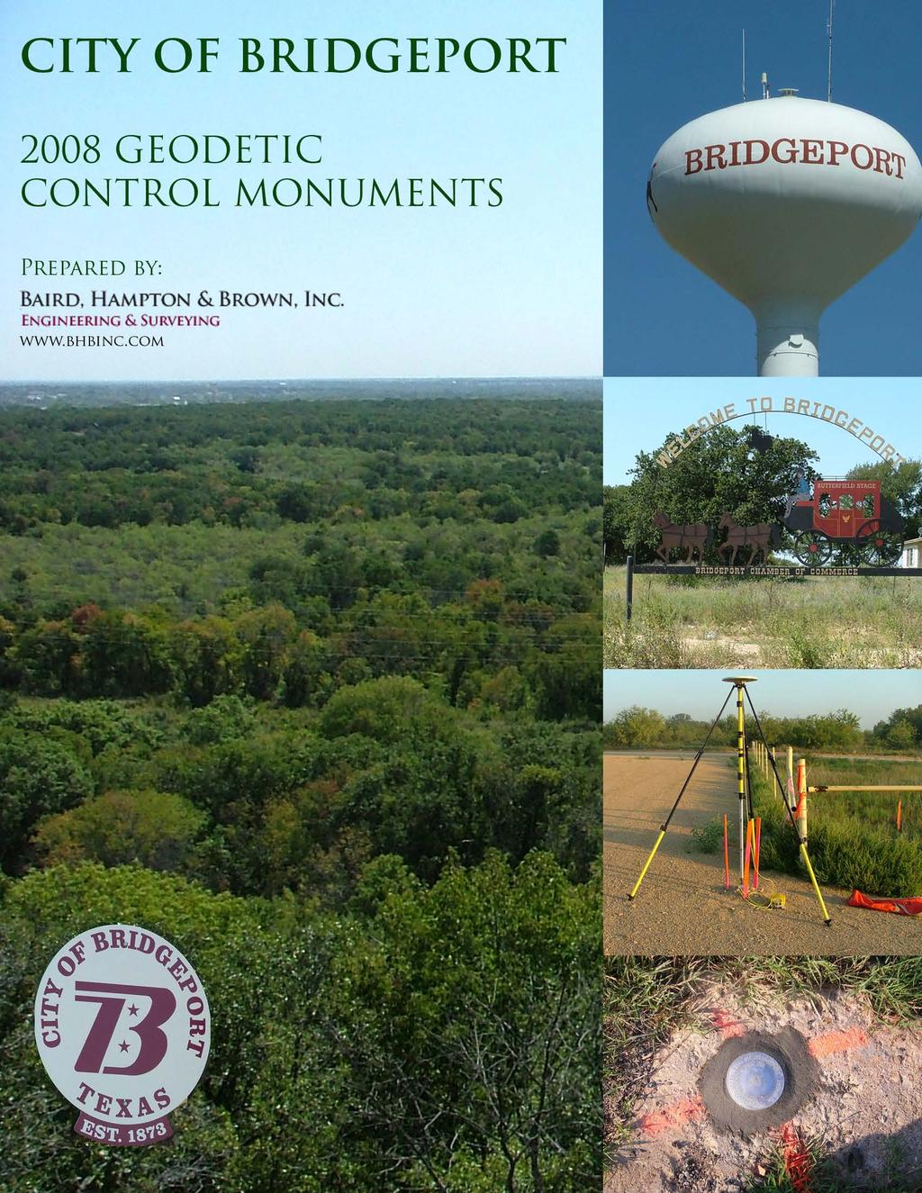
2 1 - GEODETIC CONTROL MONUMENTATION ESTABLISHED SEPTEMBER 2008 In September 2008, Baird, Hampton & Brown established positions for 8 geodetic control monuments throughout the City of Bridgeport, Texas. After meeting with the City development team to discuss the scope, field reconnaissance teams selected 8 locations for the establishment of new monuments, as well as, the incorporation of the Primary Airport Control Station at the Bridgeport Municipal Airport, PID AB2811. The positions were selected based upon the following location attributes: 1. Coverage 2. Current surrounding development 3. Safety in accessing and occupying 4. Longevity 5. Stability and accessibility 6. Sky visibility, both now and future observations Each new position was monumented with a 3 ½-inch aluminum disk set in concrete or on ¾-inch iron rods driven to refusal. New monuments set in concrete were set with disk manufacturer recommended mortar. Monuments established by iron rod are housed in a 40-inch long 6-inch diameter Schedule 40 PVC sleeve set in concrete and filled with sand. The PVC sleeves are capped with 6-inch aluminum access covers set flush with the natural ground. Observations used to determine position for each of the monuments consist of a minimum of two (2) independent static observations, occupied for a minimum of two (2) hours each. All positions were observed with Trimble 5700 Dual Frequency receivers using Zephyr Geodetic and Zephyr Geodetic w/ Ground Plane antennas. Coordinates for the new positions were generated using Trimble Geomatics Office v1.63. The Primary Airport Control Station, PID AB2811, designation IF9 A was used as the coordinate seed for all direct and indirect baseline solutions. Holding as fixed the published values for AB2811, all baseline solutions from this point were either L1 fixed or Iono free fixed solutions. Horizontal Information All horizontal values shown are based upon baseline solutions from AB2811. Raw observables for each session were further uploaded to the Online Positioning User Service (OPUS) as a secondary independent check. Horizontal datum is NAD83(2007). Published State Plane Coordinates are listed in Texas North Central Zone (4202) in US feet and meters. Vertical Information All orthometric heights (elevation) shown are based upon OPUS solutions using three GPS Continuously Operating Reference Stations: Decatur CORS ARP ID:TXDC, PID-DH7139, TX/WISE Jacksboro CORS ARP ID:TXJA, PID-DH7143, TX/JACK Weatherford CORS ARP ID:TXWE, PID-DH7153, TX/PARKER Geoidal separation was determined using GEOID03. Vertical datum is NAVD88. Published elevations are listed in US feet and meters.
3 3 CONTROL MONUMENT DESCRIPTIONS #1 A 3-1/2 inch aluminum cap with access lid set in the south lawn of the U.S. Post Office located at 1305 Halsell Street. Monument is located approximately 8 feet north of the north curb line of Halsell Street, 13 feet south of the sidewalk of the west parking lot for the post office, and approximately 106 feet east of the intersection of Halsell and 13 th Street centerlines. #2 HIGH SCHOOL A 3-1/2 inch aluminum cap with access lid set in the west lawn of Bridgeport High School located at 1 Maroon Drive. Monument is located approximately 82 feet north of the north curb line of Maroon Drive, 45 feet east of the east edge of asphalt of Overland Drive, and 83 feet west of the west parking lot for the high school. #3 DEPOT A 3-1/2 inch aluminum cap set in the remains of the concrete foundation of the Old train depot. The monument is located approximately 30 feet northeast of the centerline of the Union Pacific rail road tracks, approximately 74 feet west of the west edge of asphalt of State Highway, and approximately 60 feet north of the centerline of Cates Street. #4 A 3-1/2 inch aluminum cap set at 2008 State Highway (a.k.a. State Highway ). Monument is located at the southeast corner of a 6 foot by 20 foot concrete curb inlet located on the east side of State Highway and located approximately 1000 feet (0.2 miles) southeast of the intersection of U.S. Highway and State Highway. #5 16 th A 3-1/2 inch aluminum cap located at 2008 U.S. Highway. Monument is set in the west end of a 40 foot concrete headwall on the north side of U.S. Highway and located approximately 400 feet east of the intersection of U.S. Highway and 16 th Street, 40 feet north of the north edge of the westbound lane of U.S. Highway, and 120 feet west of Johns Street. #6 INDUSTRIAL A 3-1/2 inch aluminum cap set in the south end of a 5 foot concrete headwall on the east side of State Highway, and approximately 250 north of the intersection of State Highway and F.M Monument is located approximately 3 feet east of the guard rail. #7 REC PARK A 3-1/2 inch aluminum cap located in the City of Bridgeport Recreation Park. From the intersection of U.S. Highway and State Highway, proceed north on approximately 0.85 miles to the main entrance of the Recreation Park on the west side of. Proceed westerly across the rail road tracks, along a gravel road (previously posted as Wesco Stone Spur) approximately 1.2 miles to the top of a hill. On the south side of the gravel road is a tank battery with perimeter fence. The monument is a 3-1/2 inch aluminum cap set 4 feet southwest of a metal fence corner post for the southwest corner of the perimeter fence. #8 AIRPORT A steel rod with a punch hole encased in a 5-inch pvc pipe set in concrete is located at the City of Bridgeport Municipal Airport. The monument is a Primary Airport Control Station (PAC) designated IF9 and identified by PID # AB2811. The monument is located 550 feet southeast of the intersection of U.S. Highway and Private Road 3509 and 170 feet east of the east edge of asphalt of Private Road 3509, and 4 feet west of a fence corner post.


4 CRITTENDON 123 FROST tu PRIVATE ROAD PRIVATE ROAD 1522 tu WOODVILLE CATES COUNTRY CLUB 12TH 1 tu 1 GARY VINE 1 17TH LANICE BOSTON OVERLAND RIDGEWOOD 3214 CUBA 1 Geodetic Control Monument No. 1 Halsell B C A STREET STREET A = 8 B = 13 C = 106 A 3-1/2 inch aluminum cap with access lid set in the south lawn of the U.S. Post Office located at 1305 Halsell Street. Monument is located approximately 8 feet north of the north curb line of Halsell Street, 13 feet south of the sidewalk of the west parking lot for the post office, and approximately 106 feet east of the intersection of Halsell and 13 th Street centerlines.


5 CRITTENDON PRIVATE ROAD 1522 BASS tu WOODVILLE BLOCKER CATES 1 THOMPSON 1 GARY VINE 18TH 17TH ROBINHOOD FROST GRACE SHIRLEY LANICE SHIRLEY BOSTON OVERLAND RIDGEWOOD HIGH SCHOOL tu CUBA PRIVATE ROAD PRIVATE ROAD COUNTRY CLUB FM 2123 tu Geodetic Control Monument No. 2 High School A = 82 B = 45 C = 83 OVERLAND DRIVE B A C MAROON DRIVE A 3-1/2 inch aluminum cap with access lid set in the west lawn of Bridgeport High School located at 1 Maroon Drive. Monument is located approximately 82 feet north of the north curb line of Maroon Drive, 45 feet east of the east edge of asphalt of Overland Drive, and 83 feet west of the west parking lot for the high school.


6 FM PRIVATE ROAD DEPOT OWENS BASS WOODVILLE CATES COUNTRY CLUB 1 THOMPSON 1 GARY VINE 18TH 17TH ROBINHOOD FROST MOCKINGBIRD LANICE GRACE BOSTON OVERLAND DRY CREEK RIDGEWOOD 3214 CUBA Geodetic Control Monument No. 3 Depot A = 30 B = 74 C = 60 F.M. 920 A U.S. HWY B CATES STREET C A 3-1/2 inch aluminum cap set in the remains of the concrete foundation of the Old train depot. The monument is located approximately 30 feet northeast of the centerline of the Union Pacific rail road tracks, approximately 74 feet west of the west edge of asphalt of State Highway, and approximately 60 feet north of the centerline of Cates Street.


7 CRITTENDON PRIVATE ROAD 1525 PRIVATE ROAD PRIVATE ROAD BASS BLOCKER CATES 1 THOMPSON 1 VINE 18TH 17TH ROBINHOOD FROST MOCKINGBIRD LANICE BOSTON OVERLAND DRY CREEK RIDGEWOOD 3214 CUB Geodetic Control Monument No. 4 LIQUOR STORE S.H. CHICO A 3-1/2 inch aluminum cap set at 2008 State Highway (a.k.a. State Highway ). Monument is located at the southeast corner of a 6 foot by 20 foot concrete curb inlet located on the east side of State Highway and located approximately 1000 feet (0.2 miles) southeast of the intersection of U.S. Highway and State Highway.


8 CRITTENDON tu PRIVATE ROAD BASS WOODVILLE CATES BLOCKER COUNTRY CLUB 1 THOMPSON tu FM GARY VINE 1 18TH 17TH ROBINHOOD FROST 1 LANICE BOSTON OVERLAND DRY CREEK RIDGEWOOD 3214 CUBA tu PRIVAT PRIVATE ROAD Geodetic Control Monument No. 5 16th Street 1 STREET A B U.S. HWY C A = 400 B = 40 C = 120 A 3-1/2 inch aluminum cap located at 2008 U.S. Highway. Monument is set in the west end of a 40 foot concrete headwall on the north side of U.S. Highway and located approximately 400 feet east of the intersection of U.S. Highway and 16 th Street, 40 feet north of the north edge of the westbound lane of U.S. Highway, and 120 feet west of Johns Street.


9 CRITTENDON tu BASS WOODVILLE BLOCKER 3418 FM CATES CUBA COUNTRY CLUB 1 THOMPSON BRUSH 1 18TH 17TH ROBINHOOD LANICE BOSTON OVERLAND DRY CREEK RIDGEWOOD INDUSTRIAL 3214 tu Geodetic Control Monument No. 6 Industrial S.H. HWY 250 F.M A 3-1/2 inch aluminum cap set in the south end of a 5 foot concrete headwall on the east side of State Highway, and approximately 250 north of the intersection of State Highway and F.M Monument is located approximately 3 feet east of the guard rail.


10 A CRITTENDON 10 PRIVATE ROAD 1514 #7 REC PARK PRIVATE ROAD 1525 PRIVATE ROAD 1524 PRIVATE ROAD PRIVATE ROAD 1532 tu WOODVILLE 1510 #7 1 tu BASS BLOCKER tu #7 CATES 12TH #7 1 VINE Geodetic Control Monument No. 7 Rec. Park WESCO STONE C B A = 148 B = 4 C = 75 A 3-1/2 inch aluminum cap located in the City of Bridgeport Recreation Park. From the intersection of U.S. Highway and State Highway, proceed north on approximately 0.85 miles to the main entrance of the Recreation Park on the west side of. Proceed westerly across the rail road tracks, along a gravel road (previously posted as Wesco Stone Spur) approximately 1.2 miles to the top of a hill. On the south side of the gravel road is a tank battery with perimeter fence. The monument is a 3-1/2 inch aluminum cap set 4 feet southwest of a metal fence corner post for the southwest corner of the perimeter fence.


11 Bridgeport Reservoir EVANS BAY tu COLLUM ELM EARP BEACHWOOD 3510 AIRPORT 3504 PRIVATE ROAD RUNAWAY BAY PRIVATE ROAD 3501 ISLET L V SELZ U.S. HWY A C B P.R A = 550 B = 170 C = 4 Geodetic Control Monument No. 8 Airport A steel rod with a punch hole encased in a 5-inch pvc pipe set in concrete is located at the City of Bridgeport Municipal Airport. The monument is a Primary Airport Control Station (PAC) designated IF9 and identified by PID # AB2811. The monument is located 550 feet southeast of the intersection of U.S. Highway and Private Road 3509 and 170 feet east of the east edge of asphalt of Private Road 3509, and 4 feet west of a fence corner post.


12 12 and finally, a special thanks goes out to David Turnbow and the guys at the Public Services Department for their extra effort in helping us accomplish the goals of this project. Thanks again! BHB Survey
DEVELOPMENT & APPLICATION OF THE STATE COORDINATE SYSTEM
 DEVELOPMENT & APPLICATION OF THE STATE COORDINATE SYSTEM State of North Carolina North Carolina Department of Public Safety Division of Emergency Management North Carolina Geodetic Survey www.ncgs.state.nc.us/
U.S. DEPARTMENT OF COMMERCE National Oceanic and Atmospheric Administration National Ocean Service Datums Page Page 1 of 5
 Datums Page Page 1 PRIMARY BENCH MARK STAMPING: 2245 A 1982 866 2245 A TIDAL MONUMENTATION: Tidal Station disk VM#: 16408 AGENCY: National Ocean Survey (NOS) PID#: DD1345 The primary bench mark is a disk
CONFIRMED BENCHMARKS UPDATED JUNE 26, 1991
 CONFIRMED BENCHMARKS UPDATED JUNE 26, 1991 1. Chiseled square on southwest side of street light base, in median of Gus Thomasson Rd., 40' northeast of centerline of Jamaica Way. Elevation: 536.49 2. Chiseled
MAY 2017 AROUND THE BEND. Survey Economics Customers & services. Mobile Scanning Bringing the goods. Black Elk Peak Definitive elevation
 MAY 2017 AROUND THE BEND Survey Economics Customers & services Black Elk Peak Definitive elevation Mobile Scanning Bringing the goods TRUE ELEVATION BLACK ELK PEAK» JERRY PENRY, PS Black Elk Peak, located
Datum on benchmarks All benchmarks with a Township name and number are on 1929 datum:. All benchmarks with a four-digit number are on 1988 datum:
 Datum on benchmarks All benchmarks with a Township name and number are on 1929 datum:. All benchmarks with a four-digit number are on 1988 datum: LAWRENCE 2 Destroyed 8/29/05 TG General coordinates: 10800E
Preliminary Findings of Proposed Alternative
 Preliminary Findings of Proposed Alternative The attached drawing provides a schematic layout of the proposed alternative that will be discussed on July 27, 2010. A full report will follow and should be
Yellowstone Benchmarks North Entrance Road
 Yellowstone Benchmarks From the North: Reset your odometer/gps at the Roosevelt Arch From Mammoth Hot Springs: Reset your odometer/gps as you pass the Mammoth Post Office heading north Most of the benchmarks
Today s topics: Elevations by GPS Datum Transformation Tool Free Learning Opportunities
 Today s topics: Elevations by GPS Datum Transformation Tool Free Learning Opportunities IMAGIN Annual Conference Traverse City, MI June 19, 2018 John Ellingson - john.ellingson@noaa.gov Great Lakes Region
AIRPORT LAYOUT PLAN FOR FRIEDMAN MEMORIAL REPLACEMENT AIRPORT - SITE 12 FRIEDMAN MEMORIAL AIRPORT AUTHORITY INDEX OF SHEETS SHEET TITLE
 GOODING MUNICIPAL SOURCE: JeppView 3.6.3.1 (Printed May 19, 2010) MAGIC VALLEY REGIONAL BURLEY MUNICIPAL LOCATION MAP NTS - SITE 12 AIRPORT LAYOUT PLAN FOR FRIEDMAN MEMORIAL REPLACEMENT AIRPORT - SITE
Who am I? National Geodetic Survey s Great Lakes Region Geodetic Advisor. John Ellingson Cell:
 Who am I? National Geodetic Survey s Great Lakes Region Geodetic Advisor John Ellingson john.ellingson@noaa.gov Cell: 202-306-6904 Today s Discussion 1st Topic ----- New Datums Coming in 2022 2nd Topic
ADDENDUM NO. TWO AB
 ADDENDUM NO. TWO AB2018-28 Notice is hereby given that on June 22, 2018 at 11:00 A.M. (Prevailing time), sealed bids will be opened and read in public by the Purchasing Department in the Mercer County
Training Manual. Hand Rope Pump, P Model. Module 1: Production
 Training Manual PI-Model Rope Pump, Module 1, Production Training Manual Hand Rope Pump, P Model Module 1: Production June 2006, Chibombo, Zambia July 2006, Chimoio, Mozambique Arrakis September 2006 Arrakis
LANDER COUNTY RAIL ASSESSMENT NOVEMBER 2006
 of hydrologic features. A substantial proportion of the land between and north of the railroad tracks contain wetlands, as identified by the US Fish and Wildlife Service National Wetlands Inventory (NWI).
BOOGIE WOOGIE AUTO TOUR 1
 BOOGIE WOOGIE AUTO TOUR 1 4 6 3 5 7 1 2 10 9 8 Route # 1 Alternate Return Route 1 Historic Harrison County Courthouse & Museum 2 Texas & Pacific Railway Depot & Museum 3 Antebellum Childhood Home Lady
Final Drainage Letter Pikes Peak Community College Downtown Parking Lot Colorado Springs, Colorado
 Final Drainage Letter Pikes Peak Community College Downtown Parking Lot Colorado Springs, Colorado Prepared for: Pikes Peak Community College 5775 South Academy Boulevard Colorado Springs, CO 80906-5422
THREE MILE PLAN TOWN OF SUPERIOR COLORADO
 THREE MILE PLAN TOWN OF SUPERIOR COLORADO February 23, 2015 INTRODUCTION This document has been prepared by the Town of Superior, Colorado, to address the existing and proposed land uses within an approximate
Railroad Safety Trail
 2.1 INTRODUCTION AND PROJECT SETTING 2.1 Introduction & Project Setting Introduction This study is the result of a directed effort on the part of the City of San Luis Obispo to carry out previously established
IP3 IP4 LP7 IP5 IP6 IP2 IP1. Phase 1
 ? AMENDMENT No. SITUATED IN THE SW OF SECTION 8, T.S, R.W. OF THE TH P.M IP IP LP IP IP A C Phase APPROVED UNDER SEPARATE SUBMITTAL B IP IP INV IN=09.8 INV OUT=09.± MDP0-0080 No. REVISION BY Highlands
CITY OF GRANBURY ZONING BOARD OF ADJUSTMENT MINUTES
 CITY OF GRANBURY ZONING BOARD OF ADJUSTMENT MINUTES 09-26-06 The Zoning Board of Adjustment of the City of Granbury convened in regular session on Tuesday, September 26, 2006, at 5:30 p.m. in the Council
FOR SALE Glover Road, LANGLEY, BC. Don Munro
 FOR SALE 6681 Glover Road, LANGLEY, BC Don Munro 604-817-7338 +/- 583.82 Glover Road Address: 6681 Glover Road About Langley The City of Langley is located in the center of the Lower Mainland Economic
Trail Feasibility Study
 VOLUSIA COUNTY MPO CITY OF NEW SMYRNA BEACH FINAL REPORT JUNE 30, 2009 Trail Feasibility Study What s inside? 1 Introduction 2 Project Purpose & Scope 3 Physical Inventory & Assessment of Right-of- Way
City of Fort Lauderdale. Frequently Asked Questions. Proposed Sea Wall Ordinance
 City of Fort Lauderdale Frequently Asked Questions Proposed Sea Wall Ordinance The City of Fort Lauderdale is considering amending the Unified Land Development Regulations of the City of Fort Lauderdale
SIGNATURE ELEMENTS BICYCLE RACKS & FENCING NSSD HWY. 61 CAIRN & TRAIL SIGNS INTERPRETIVE KIOSK
 SIGNATURE ELEMENTS BICYCLE RACKS & FENCING NSSD HWY. 61 CAIRN & TRAIL SIGNS INTERPRETIVE KIOSK 77 SIGNATURE ELEMENTS BICYCLE RACKS & FENCING: A kiosk, signs, fencing, and bike racks were designed as a
SELF RE-ERECTING MARKER POSTS
 ONE OF A KIND TECHNOLOGY FOR OUR TIMES MULTI APPLICATIONS SELF RE-ERECTING MARKER POSTS TEMPORARY OR PERMANENT BICYCLE LANES CROSSWALKS CHANALIZATION BRIDGES CITY US REFLECTOR WORK ZONES ALL-ROUND RUGGEDNESS
United States Department of the Interior National Park Service. Boundary Expansion Listed in National Register January 11, 2017
 NPS Form 10900-a (Rev. 8/2002) OMB No. 10240018 United States Department of the Interior National Park Service Boundary Expansion Listed in National Register January 11, 2017 National Register of Historic
Tracy Ranch 403+/- Acres Comanche County, Texas $965,185 ($2,395/acre)
") Office: (214) 361-9191 Tracy Ranch 403+/- Acres Comanche County, Texas $965,185 ($2,395/acre) LOCATION: The ranch is located in the northwestern portion of Comanche County near the Eastland County line,
Office: (214) 361-9191 Tracy Ranch 403+/- Acres Comanche County, Texas $965,185 ($2,395/acre) LOCATION: The ranch is located in the northwestern portion of Comanche County near the Eastland County line,
DRAFT. Dorabelle Campground Rehabilitation
 DRAFT Dorabelle Campground Rehabilitation September 2012 1.1 REGIONAL SETTING AND PROJECT LOCATION The Dorabelle Campground is located on the western shore of Shaver Lake in Fresno County, California (Section
Reliance-TC-Type l Standard Horizontals-Aluminum Pressure Plates Integral TC Verticals w/o Face Cap - 2-1/2 x 6
 Reliance-TC-Type l Standard Horizontals-Aluminum Pressure Plates Integral TC Verticals w/o Face Cap - 2-1/2 x 6 Table of Contents (Drawing numbers ie H3505 used as CAD detail reference only ) Elev-RcwTC-Type
Reliance-TC-Type l Standard Horizontals-Aluminum Pressure Plates Integral TC Verticals w/o Face Cap - 2-1/2 x7-1/4
 Reliance-TC-Type l Standard Horizontals-Aluminum Pressure Plates Integral TC Verticals w/o Face Cap - 2-1/2 x7-1/4 Table of Contents (Drawing numbers ie H3405 used as CAD detail reference only ) Elev-RcwTC-Type
DATA BOOK IV : COST ESTIMATE
 The Study on Comprehensive Disaster Prevention around Mayon Volcano DATA BOOK IV : COST ESTIMATE DT IV List of (1/5) Clearing and Grubbing ha 59,192.92 Excavation (Road way & Drainage) Mech. cu.m 80.55
McDonald Manufacturing, Inc.
 McDonald Manufacturing, Inc. Home About Us Contact Us Downloads McDonald Manufacturing offers a wide line of lightweight all steel welded construction masonary tools. HINGES AND STRAPS MIXER BLADE 38A
RAY YENKANA Willowbrook Cr, Dawson Creek BC Canada $2,847,000
 1716 Willowbrook Cr, Dawson Creek BC Canada For SALE $2,847,000 This is a rare find, 32 townhomes in Dawson Creek, BC. Excellent investment in a single title multi family complex. Vendor has upgraded this
CE 563 Airport Design
 CE 563 Airport Design Prevent aircraft collisions Prevent aircraft collisions with obstructions Expedite and maintain an orderly flow of air traffic Air traffic control system command center Herndon, VA
4-foot Economy Sign Post. 4-foot post is rated at 2 pounds per foot. 7-foot Economy Sign Post
 Introduction: ComplianceSigns.com offers a variety of sign posts, sign mounting hardware, sign bases, mounting tape and more to mount your safety signs indoors or out. We offer three styles of sign posts,
2012 Boundary Counts October 5, 2011 Skyward Data Populations Within Boundaries October 5, 2011
 STUDENT ACHIEVEMENT ATTENDANCE BOUNDARY CHANGE BACKGROUND INFORMATION: As a result of closing Dakota Middle School at the end of the current school year and opening East Middle School, it is necessary
Canada and Alberta announce 33 new infrastructure projects
 January 28, 2010 Canada and Alberta announce 33 new infrastructure projects Stimulus funding will create jobs, stimulate regional economy Calgary... Rob Merrifield, Minister of State (Transport), and Luke
2600 COLORADO ENTRY DESIGN
 2600 COLORADO ENTRY DESIGN SANTA MONICA ARB REVIEW COVER 2600 COLORADO AVENUE, SANTA MONICA, CALIFORNIA 11/13/2017 A001 PROJECT DESCRIPTION 2600 COLORADO WILL SERVE AS A NEW HOME FOR ORACLE CORPORATION.
Photo Album Intact/Slightly Altered. Eligible, see Statement of Significance. Roadside Development on Minnesota Trunk Highways,
 Historic Name CS # 5202 Other Name SHPO Inv # Location Hwy District Reference City/Township County Courtland Township Nicollet Acres 4.6 Twp Rng Sec 110N 30W Sec 22 Rest Area Class 4 USGS Quad UTM New
AUGUST 2017 GNSS REVIEW. Survey Economics Chances of success. Mobile Mapping Airport scanning. Stag s Leap Winery Pre-construction plan
 AUGUST 2017 GNSS REVIEW Survey Economics Chances of success Stag s Leap Winery Pre-construction plan Mobile Mapping Airport scanning RISING PERFORMANCE» ERIK DAHLBERG Civil aviation is an outlier. It s
APPENDIX K: BUILT HERITAGE AND CULTURAL HERITAGE LANDSCAPES
 APPENDIX K: BUILT HERITAGE AND CULTURAL HERITAGE LANDSCAPES TABLE 1: Built Resources (BHR) and Cultural Heritage Landscapes (CHL) Within and Adjacent to the West Whitby Secondary Plan Area Site # 1. CHL
ALPINE PIPELINE RIVER CROSSINGS 2009 MONITORING REPORT
 ALPINE PIPELINE RIVER CROSSINGS 2009 MONITORING REPORT Submitted to ConocoPhillips Alaska, Inc. Submitted by Michael Baker, Jr., Inc. 1400 West Benson Blvd., Suite 200 Anchorage, Alaska 99503 TABLE OF
RISING PERFORMANCE. Civil aviation is an outlier. It s BY ERIK DAHLBERG
 RISING PERFORMANCE Compact mobile mapping systems can be installed on small passenger cars. Civil aviation is an outlier. It s among the few industries where tight government regulations are widely accepted
2013 Regional Water System Improvements Program Public Hearing March 14, 2013
 In support of Illinois Environmental Protection Agency State Revolving Fund Loan Application 2013 Regional Water System Improvements Program Public Hearing March 14, 2013 Village of Oak Lawn Customer Communities:
Gas Conversion Kits and Instructions
 Gas Conversion Kits and Instructions INSTALLATION FORM RGM 432/433-GC (Version D.1) Obsoletes Form RGM 432/433-GC (Version D) APPLIES TO: Model FT and Model SFT All gas conversion must be done by a qualified
YCU 750 TU Unitized Curtain Wall System
 INSTALLATION INSTRUCTIONS 1 2 Installation Manual 2010 YKK AP America Inc. is a subsidiary of YKK Corporation of America. TABLE OF CONTENTS Installation Notes........................................ Page
SANTA FE MUNICIPAL AIRPORT (SAF) SANTA FE, NM
 SANTA FE, NM") SEPTEMBER 13-15, 2018 SANTA FE MUNICIPAL AIRPORT (SAF) SANTA FE, NM SPECIAL FLIGHT PROCEDURES EFFECTIVE: Thursday Sept 13, 2018 12:00 NOON MDT until 7:00 PM MDT Friday Sept 14, 2018 7:00 AM MDT until 7:00
SEPTEMBER 13-15, 2018 SANTA FE MUNICIPAL AIRPORT (SAF) SANTA FE, NM SPECIAL FLIGHT PROCEDURES EFFECTIVE: Thursday Sept 13, 2018 12:00 NOON MDT until 7:00 PM MDT Friday Sept 14, 2018 7:00 AM MDT until 7:00
 203.0100 Removing Small Pipe Culverts CATEGORY STATION LOCATION EACH 0010 2+00-16+50 0010 7+13-8+41 LT. 155 3 0010 4+42 CL 1 10,660 9+90-13+73 RT. 390 3 7+63'SB' 67' LT. 1 14+25'GV' 49' LT. 1 17+05'GV'
MEMORANDUM. DATE: May 16, TO: Monica Harrower, PennDOT District 6-0. Mary Alfson Tinsman CHRS, Inc. 451 North Cannon Avenue, Suite 100B
 MEMORANDUM DATE: May 16, 2011 TO: Monica Harrower, PennDOT District 6-0 FROM: RE: Mary Alfson Tinsman CHRS, Inc. 451 North Cannon Avenue, Suite 100B Lansdale, PA 19446 French Creek Parkway Project Phoenixville
RAPID CITY AREA SCHOOL 51/ th Street Rapid City, SD Assistant Superintendent. Date: October 14, Board of Education, Dr.
 RAPID CITY AREA SCHOOL 51/4 300 6 th Street Rapid City, SD 57701 Assistant Superintendent Student Achievement (605) 394-4037, (605) 394-5147 Fax (605) 394-4062 Date: October 14, 2011 To: From: Cc: Subject:
Data Origination, Management and WGS 84. ICAO PBN Seminar Data Origination & Management and WGS 84
 Data Origination, Management and WGS 84 1 Learning Objectives Overview Understand the implication of publishing incorrect navigational data in the State s AIP Identify why it is essential to use a common
WHEREAS, that the Township of Blairstown is agreeable to assuming the
 TOWNSHIP OF BLAIRSTOWN COUNTY OF WARREN STATE OF NEW JERSEY ORDINANCE NO. 2018-014 AN ORDINANCE APPROVING THE EXCHANGE OF OWNERSHIP OF ROADWAYS AND CULVERTS LOCATED IN BLAIRSTOWN TOWNSHIP WITH THE COUNTY
The safe & affordable install
 QSLG1000 Quick-Sling SPECS QSLG1000 Each arm attaches to wood using 2 zip screws for stability & a 4 through bolt & wing nut for security. Installs to steel using steel beam adapters. 28 points of anti-vibration
Overview ICAO Standards and Recommended Practices for Aerodrome Mapping Data reported to AIM
 Overview ICAO Standards and Recommended Practices for Aerodrome Mapping Data reported to AIM References ICAO SARPS Annex 14 Vol. I, 7 th Edition, July 2016 ICAO SARPS Annex 15, 15 th Edition, July 2016
Oceano Dunes SVRA (Pismo Beach)
") SCLR Event Oceano Dunes SVRA (Pismo Beach) September 19-20, 2009 When: Where: What: September 19 nd and 20 th Oceano Dunes SVRA Pismo Beach, California Sand Dunes, camping, games, food, driving challenges,
SCLR Event Oceano Dunes SVRA (Pismo Beach) September 19-20, 2009 When: Where: What: September 19 nd and 20 th Oceano Dunes SVRA Pismo Beach, California Sand Dunes, camping, games, food, driving challenges,
ADVANCED WARNING SYSTEM FOR SHARED USE CROSSING ON HOWARD STREET EAST OF NORDICA AVENUE
 ADVANCED WARNING SYSTEM FOR SHARED USE CROSSING ON EAST RDICA AVENUE FOR THE LOCATION MAP STANDARD SYMBOLS FEATURE EISTING PROPOSED BENCHMARK BM/TBM SHEET INDE. BM/TBM TITLE SHEET CONCRETE R.O.W. MONUMENT
AMS Gas Vapor Probe Systems (GVP)
") AMS Gas Vapor Probe Systems (GVP) AMS GVP systems are equipped with two different styles of 5/8in OD extensions: solid tile probe extensions, and hollow GVP rods. Extendable tile probe extensions are solid
AMS Gas Vapor Probe Systems (GVP) AMS GVP systems are equipped with two different styles of 5/8in OD extensions: solid tile probe extensions, and hollow GVP rods. Extendable tile probe extensions are solid
SOPs for Cedar Valley Airport UT10
 SOPs for Cedar Valley Airport UT10 Cedar Valley Airport is a privately owned airport located approximately 10 miles west of Lehi, Ut and 5 miles northeast of Cedar Fort, UT. The airport location is N40.3572
Building Permit Application
 Building Permit Application Co-Owner Name Lot # Address City State Zip Phone (home) (cell) Contractor (if applicable) The above named co-owner hereby makes application to Cedar Shores Campground Condominium
Treaty Oaks Ranch 323+/- Acres Hood County, Texas $1,776,500
 Bret Polk Mobile: (254) 965-0349 Office: (214) 361-9191 Treaty Oaks Ranch 323+/- Acres Hood County, Texas $1,776,500 LOCATION: The ranch is located in a desirable area 10+/- miles south of Granbury, Texas,
Datum Issues in the Red River of the North Basin ----
 Datum Issues in the Red River of the North Basin ---- Scoping Document May 1999 Russell E. Harkness, Hydrologist United States Geological Survey Water Resources Division 2 EXECUTIVE SUMMARY Two datum issues
Mud Creek and West Mud Creek
 Mud Creek and West Mud Creek Recreational Use Attainability Analysis Summary of Findings Texas Institute for Applied Environmental Research Stephenville, Texas September 15, 2014 1 Project Partners Texas
Lincoln Village Pedestrian Bicycle Bridge Community Meeting September 13th, 2016
 Lincoln Village Pedestrian Bicycle Bridge Community Meeting September 13th, 2016 Purpose of the Meeting Introduce the project and the proposed improvements Review existing conditions Discuss the needs
DAMAGE ASSESSMENT OF SAND FENCING GARDEN CITY, NORTH LITCHFIELD AND LITCHFIELD BEACH GEORGETOWN COUNTY, SC
 OF SAND FENCING GARDEN CITY, NORTH LITCHFIELD AND LITCHFIELD BEACH GEORGETOWN COUNTY, SC June 07, 2017 PREPARED FOR: GEORGETOWN COUNTY DEPARTMENT OF PUBLIC SERVICES PREPARED BY: The EARTHWORKS Group 11655
The Needle View Ranch
 The Needle View Ranch Hot Springs County, Wyoming Presented by: 58 E. Benteen Street Buffalo, Wyoming 307-684-9556 or 888-684-9557 SUBJECT The Needle View Ranch is located approximately 14.5 miles northwest
NPS Form a OMB No (8-86) Expires
 Expires") Section: F Page 247 Railroads in Minnesota, 1862-1956 Figures Railroad Roadway Edge of Right of Way Edge of Right of Way Railroad Bed Figure 1. Railroad Corridor, Young America vicinity, ca. 1915 Section:
Section: F Page 247 Railroads in Minnesota, 1862-1956 Figures Railroad Roadway Edge of Right of Way Edge of Right of Way Railroad Bed Figure 1. Railroad Corridor, Young America vicinity, ca. 1915 Section:
HWY 7 COMMERCIAL PROPERTY 1135 W. Highway 7, Hutchinson, MN 55350
 OFFERING SUMMARY SALE PRICE: $825,000 LOT SIZE: 2.03 Acres YEAR BUILT: 2006 BUILDING SIZE: 11, 640 PROPERTY OVERVIEW Commercial Office, Warehouse Building with superior highway visibility and easy access
 CEMVP-PD-C MEMORANDUM FOR FILE SUBJECT: Supplement No. 4,, Design Memorandum 10, Kaskaskia River, Illinois 1. References: a., Design Memorandum No. 10, approved 1997 (includes Supplements 1-3) b. ER 1130-2-550,
Mr. Michael Malone CPS Energy 145 Navarro Street San Antonio, Texas Project No
 January 15, 2016 Mr. Michael Malone 145 Navarro Street San Antonio, Texas 78205 Project No. 0328985 Environmental Resources Management CityCentre Four 840 West Sam Houston Pkwy N. Suite 600 Houston, Texas
FOAM PROPORTIONING EQUIPMENT
 10 VERTICAL & HORIZONTAL BLADDER TANKS DESCRIPTION All valves are labeled showing normal working position. Buckeye Bladder Tanks store foam concentrate and are one component of a Balanced Pressure Foam
MORGAN CREEK GREENWAY Final Report APPENDICES
 APPENDICES MORGAN CREEK GREENWAY Appendix A Photos of Existing Conditions in Trail Corridor Photos of existing conditions Main trail corridor - February 2009 Photos of existing conditions south bank Morgan
Cultural Resource Management Report Deer Valley 4wd Restoration and Blue Lakes Road Maintenance Project R
 Cultural Resource Management Report R2015-05-03-10005 Undertaking Description: The proposes to perform road maintenance and meadow restoration on the Deer Valley 4wd trail and road maintenance on the Blue
7289 Silvermine Rd, Harwood Vacant Acreage - Manufactured Home NOT included. 204 Richland Dr, Lockhart Vacant Lot
 511 Ash St, Lockhart 833 sqft House built in 1920 7289 Silvermine Rd, Harwood Vacant Acreage - Manufactured Home NOT included 204 Richland Dr, Lockhart Vacant Lot 7519 Silvermine Rd, Harwood Vacant Acreage
2015 Annual Water Report. City of Revelstoke Engineering and Public Works Department
 2015 Annual Water Report City of Revelstoke Engineering and Public Works Department P a g e 1 Table of Contents Introduction... 3 Revelstoke Water Distribution System... 3 Greeley Creek Water Treatment
All that part of Lot 11, Sunset Hill, a subdivision in the City of Overland Park, Johnson County, Kansas, more particularly described as follows:
 NOTICE OF PUBLIC HEARING CITY PLANNING COMMISSION CITY OF OVERLAND PARK, KANSAS Notice is hereby given that the City Planning Commission of Overland Park, Kansas, will hold a public hearing Monday, February
Series SSG and Captured corner mullion. Installation Instructions
 Series 5500 SSG and Captured corner mullion Installation Instructions Part NO. Y556 February 2013 SECTION TABLE OF CONTENTS S-5500 SSG and Captured Corner Mullion Installation Instructions PAGE I. General
Adapter, Assy, Union (NSN)
") Adapter, Assy, Union (NSN) 4730-01-527-7638 Blanket, Pump (NS) 5640-01-527-4925 Blanket, Thermal 10FT (NSN) 452001-527-6307 Blanket, Thermal 20FT (NSN) 4520-01-527-6316 Blanket, Thermal 20 FT (NSN) 4520-01-527-6323
Adapter, Assy, Union (NSN) 4730-01-527-7638 Blanket, Pump (NS) 5640-01-527-4925 Blanket, Thermal 10FT (NSN) 452001-527-6307 Blanket, Thermal 20FT (NSN) 4520-01-527-6316 Blanket, Thermal 20 FT (NSN) 4520-01-527-6323
Photographic Log Client: Project Number: Site Location: Site Name: Photograph ID: Date: Location: Direction: Comments: Photograph ID:
 Photograph ID: 1 west View of one of the monitoring well and the large parking lot on the south side of Center Street. Photograph ID: 2 Monitoring well located in the middle of the parking lot located
Sliplining of Lock-Bar Steel Water Mains, Wilmington Delaware
 Sliplining of Lock-Bar Steel Water Mains, Wilmington Delaware Andrew Jakubowitch, PE, Hatch Mott MacDonald Who is Hatch Mott MacDonald? An award-winning, full-service North American engineering consulting
RETRACTABLE HOSE REEL
 RETRACTABLE HOSE REEL 30 METRE HOSE LENGTH MODEL NO. YWRHR30A OPERATING INSTRUCTIONS INTRODUCTION - MODEL NO. YWRHR30A This reel is made of high-quality materials and parts, driven and released by a spring,
Projected Advertisement Date
 2013 Planned s CY 2013 and CY 2014 Richmond District Schedule Preliminary Engineering Task Order Contracts SR 288/SR 145 Survey, 288 90349 Chesterfield Ramp and Signal Design 2/27/2013 $ 0.19 I-64 Over
YCW 750 SplineTech Shop Glazed Curtain Wall System Installation Manual
 YCW 750 SplineTech Shop Glazed Curtain Wall System Installation Manual 2009 YKK AP America Inc. is a subsidiary of YKK Corporation of America. TABLE OF CONTENTS Installation Notes........................................
6 East Gay Street, West Chester, PA Brad Palmer, West Chester Coffee & Ice Cream Bar. Feb. 10th Tommy Ciccarone, Jr, 2/12/18
 6 East Gay Street, West Chester, PA 19380 Brad Palmer, West Chester Coffee & Ice Cream Bar Feb. 10th 2018 Tommy Ciccarone, Jr, 2/12/18 6 E. Gay Street, West Chester PA 19380 The West Chester Coffee & Ice
Sewer Variance for Longwood Development (property w/in The Peninsula at Golden Isles PD Text excluding the existing lots in Phase I) (WSV3551)
 (WSV3551)") COMMUNITY DEVELOPMENT DEPARTMENT 1725 Reynolds Street, Second Floor, Brunswick, GA 31520 Phone: 912:554-7492/Fax: 1-888-261-4757 TO: FROM: RE: Glynn County Board of Commissioners Pamela Thompson, Director
COMMUNITY DEVELOPMENT DEPARTMENT 1725 Reynolds Street, Second Floor, Brunswick, GA 31520 Phone: 912:554-7492/Fax: 1-888-261-4757 TO: FROM: RE: Glynn County Board of Commissioners Pamela Thompson, Director
Pattullo Bridge Replacement Project
 Pattullo Bridge Overview This document will: Explain the challenges facing the Pattullo Bridge today Share how we propose moving forward translink.ca PAGE 1 History By Order of the Lieutenant Governor
Town of Luray ADA Status Research
 ID PROBLEM DESCRIP SEPARA COMPLE 1 S Sidewalk - 1005 E. Main St. EAST MAIN ST 2 A Meter Box Gap - 1016 E. Main St. 32" EAST MAIN ST 3 S Sidewalk - 1005 E. Main St. EAST MAIN ST 4 S Sidewalk - across from
CITY OF MURFREESBORO HISTORIC ZONING COMMISSION. Regular Meeting June 19, :30 PM, Council Chambers, City Hall
 CITY OF MURFREESBORO HISTORIC ZONING COMMISSION Regular Meeting June 19, 2018 3:30 PM, Council Chambers, City Hall I. Call to Order and determination of a quorum II. Approve Minutes of the Regular Meeting
URBAN DESIGN ESSENTIALS. Good choice Better service Best result ISSUE 1
 URBAN DESIGN ESSENTIALS LITTER RECEPTACLES l BIKE RACKS l BOLLARDS l DRINKING FOUNTAINS l TREE FURNITURE ISSUE 1 Good choice Better service Best result Quality ISO 9001 Certified System TM LITTER RECEPTACLES
The Rodman s Guide to Madison Vertical Datums
 The Rodman s Guide to Madison Vertical Datums by Dan Rodman, Wisconsin Professional Land Surveyor No. 2793 City of Madison, WI Parks Division E-mail: drodman@cityofmadison.com Tel: (608)266-6674 Version:
FIRE Equipment Fire Training Equipment 105, , Total of Equipment 105, ,
 FIRE Equipment Fire Training Equipment 105,000-105,000 - - - - - - - - - - Total of Equipment 105,000-105,000 - - - - - - - - - - Fire Apparatus Aerial Ladder Replacement 5,320,000 1,120,000 - - 1,400,000
THE ESCALADE Westbank Drive, Austin, Texas 78746
 SM The Escalade is well positioned within the desirable Southwest submarket, situated close to a multitude of restaurants, shopping, and hotels as well as major employment centers. The property provides
Springettsbury Township. Road Improvement Projects
 Springettsbury Township Road Improvement Projects 2009 2016 2016 Township Road Improvement Projects Springettsbury Township is divided into the following 4 Sectors: Northwest Sector Sherman Street Route
DD FORM 3009, FEB 2016 REPLACES DA FORM 1247, WHICH IS OBSOLETE. Page 1 of 6 Pages Adobe Professional X
 ROUTE CLASSIFICATION For use of this form, see ATP 3-34.81/MCWP 3-17.4; the proponent agency is TRADOC. SECTION I 1. SERIAL NUMBER 2. TO 3. FOR INFORMATION 4. DATE/TIME GROUP 5. NUMBER OF SHEETS OR ENCLOSURES
Hancock. Hancock. Hancock County Population 54,558. Land Area (sq mi) 1,587 Bridges 120 Highway Corridor Priority Miles HCP 1 81 HCP 2 34
 1,587 Bridges 120 Highway Corridor Priority Miles HCP 1 81 HCP 2 34") Hancock Hancock County Population 54,558 T3 ND Oqiton Twp Land Area (sq mi) 1,587 Bridges 120 Highway Corridor Priority Miles T41 MD 81 HCP 2 34 T39 MD T40 MD 141 HCP 4 62 215 Total -5 533 T32 MD Great
Hancock Hancock County Population 54,558 T3 ND Oqiton Twp Land Area (sq mi) 1,587 Bridges 120 Highway Corridor Priority Miles T41 MD 81 HCP 2 34 T39 MD T40 MD 141 HCP 4 62 215 Total -5 533 T32 MD Great
Lake Manitou Dam and Spillway Upgrade
 South Bend Lake Manitou Dam and Spillway Upgrade Fort Wayne Rochester Indiana 1828 to 2017 Lafayette Sky Medors, P.E., LFA David Nance, P.G., IDNR Project Background Location: Rochester Indiana, Central
St. Croix Savanna SNA
 N44 59.954 W92 46.946 N44 59.906 Na ve Plant Communi es* Dry Sand - Gravel Oak Savanna (Southern) * Source: Minnesota Biological Survey N44 59.673 W92 46.734 N44 59.754 W92 46.748 National Wetlands Inventory
Minimum Specifications/Questionnaire Bid Results for One (1) New Fuel Dispensing System-Helvetia Shop 12/19/2017
 New Fuel Dispensing System-Helvetia Shop 12/19/2017") Minimum Specifications/Questionnaire Bid Results for One (1) New Fuel Dispensing System-Helvetia Shop 12/19/2017 Winning Bid PERMIT FEES, FORMS, PLANS and NOTIFICATIONS Secure all necessary state and local
Minimum Specifications/Questionnaire Bid Results for One (1) New Fuel Dispensing System-Helvetia Shop 12/19/2017 Winning Bid PERMIT FEES, FORMS, PLANS and NOTIFICATIONS Secure all necessary state and local
Port MacKenzie Rail Extension
 Port MacKenzie Rail Extension Project The Matanuska-Susitna Borough (MSB) and the Alaska Railroad Corporation (ARRC) jointly propose construction and operation of a new rail line to connect the Borough
BE IT ORDAINED by the Mayor and the City Council of the City of Papillion as follows:
 ORDINANCE NO. 1798 AN ORDINANCE TO AMEND CHAPTER 24, SECTION 1 DELINEATING THE VOTING BOUNDARY WARDS FOR THE CITY OF PAPILLION; TO REPEAL THE EXISTING CHAPTER 24, SECTION 1; AND TO PROVIDE FOR AN EFFECTIVE
Great Basin Drive, Yosemite to Las Vegas (C18A-3)
") Great Basin Drive, Yosemite to Las Vegas (C18A-3) After finishing up with the California parks, I left Yosemite and entered the Great Basin, which spans a large area east of the Sierra Nevada mountains
Great Basin Drive, Yosemite to Las Vegas (C18A-3) After finishing up with the California parks, I left Yosemite and entered the Great Basin, which spans a large area east of the Sierra Nevada mountains
Airport Planning Area
 PLANNING AREA POLICIES l AIRPORT Airport Planning Area LOCATION AND CONTEXT The Airport Planning Area ( Airport area ) is a key part of Boise s economy and transportation network; it features a multi-purpose