EVAN-THOMAS PROVINCIAL RECREATION AREA
|
|
|
- Emily Leonard
- 5 years ago
- Views:
Transcription

1 EVAN-THOMAS PROVINCIAL RECREATION AREA MANAGEMENT PLAN October 8, 2004 PARKS AND PROTECTED AREAS DIVISION
2 International Standard Book Number: For copies of this report, contact: Alberta Community Development Parks and Protected Areas Kananaskis Country Railway Ave. Canmore, AB T1W 1P1 Web site: Telephone: (403) Fax: (403) PREFACE The Evan-Thomas Provincial Recreation Area Management Plan provides a long-term vision and day-to-day guidance for stewardship of this Protected Area. The plan was prepared within the context of existing legislation and regulations. It outlines the type and extent of outdoor recreation and tourism opportunities, facilities and services including the delivery of heritage appreciation programs that assist Albertans and visitors to understand and appreciate our natural heritage while ensuring its ongoing preservation. The Management Plan was prepared with extensive public input and will be reviewed and revised periodically to reflect the current thinking of Albertans about how our natural heritage will be preserved for present and future generations. The Minister responsible for Parks and Protected Areas has authorized the implementation of the Management Plan and retains the authority to amend or interpret its provisions.
3 TABLE OF CONTENTS 1.0 INTRODUCTION Background Area Description Purpose and Scope of Management Plan Public Involvement ROLE IN ALBERTA S NETWORK OF PROTECTED AREAS Legislation and Classification System Objectives Natural Regions Framework Natural History Themes Guiding Principles OVERVIEW OF PROTECTED AREA Visitor Facilities Visitor Use Tourism/Commercial Recreation Development Policies and Guidelines Community Facilities and Services Natural Features Geology/Landforms Climate Fisheries Vegetation Wildlife Historical/Cultural Resources Heritage Appreciation MANAGEMENT INTENT AND OBJECTIVES BOUNDARY AMENDMENTS ZONING MANAGEMENT GUIDELINES Outdoor Recreation Heritage Appreciation Tourism and Commercial Recreation Community Facilities/Services Preservation Geological/Landforms Fisheries Vegetation Wildfires Wildlife Cultural DISPOSITIONS REGIONAL INTEGRATION Adjacent Land Use.26 Page i
4 10.0 IMPLEMENTATION OF PLAN Roles Research Signage 27 MAPS Map 1..2 Map 2..7 Map 3 19 LIST OF REFERENCES 28 APPENDICES 29 Page ii
5 1.0 INTRODUCTION 1.1 Background The Evan-Thomas Provincial Recreation Area (PRA) was established in 1982 and enlarged in 1986 to include hotels at the Kananaskis Village and the Nakiska ski hill. While most provincial recreation areas in Kananaskis Country are small and restricted to the immediate vicinity of individual recreation facilities, the Evan-Thomas is larger (4400 hectares) and contains several large recreation nodes. The larger size allowed for the use of readily visible boundaries (e.g., ridgelines, trails, highway) and the inclusion of a buffer to ensure public safety within the Provincial Recreation Area especially during the hunting season on surrounding lands. Also, some room was left for possible future ski hill expansion north of the existing runs. The number, size and diversity of facilities and recreation opportunities in the Evan-Thomas make this the most significant recreational area within Kananaskis Country. 1.2 Area Description The Evan-Thomas Provincial Recreation Area is located in the Kananaskis Valley (see Map 1). It is easily accessible by vehicle in an hour or less from both Calgary and Canmore via the Trans Canada Highway and Highway 40. It includes a portion of the Kananaskis River and important valley bottom habitat as well as forested and open slopes on both Mt. Kidd and Mt. Allan. It is bordered on the west and north by Bow Valley Wildland Park and Bow Valley Provincial Park. On the east it is bordered by a strip of provincial Crown land designated as part of the Kananaskis Country Forest Land Use Zone and the Elbow-Sheep Wildland Park. On the west and south, it is bordered by Spray Valley Provincial Park. Elevations range from 1400 m at the lowest point to over 2800 m at the summit of Mt. Allan. The varied slopes, elevations and aspects of this area along with the prevailing winds, sunshine and moisture regimes create very diverse vegetative and faunal communities as well as high scenic qualities. The Evan-Thomas includes alpine, subalpine and montane life zones with the montane being most significant due to its biological diversity. Besides several important habitat areas (e.g., high slopes of Mt. Allan, Marmot Basin, river floodplain), the Evan-Thomas also includes important local and regional movement corridors for a variety of wildlife. The Evan-Thomas Creek alluvial fan and the morainal terraces on the west side of the valley accommodate the major recreation/tourism facilities in Kananaskis Country including two hotels, (411 rooms), a 36-hole golf course, Mt. Kidd RV Campground, hostel, staff housing, Nakiska ski hill and several important day use sites and trails for summer and winter use (see Map 2). Kananaskis County is the only large area of Alberta's public land where the management intent is to provide a wide range of accessible outdoor recreation opportunities. The Evan-Thomas is the only area in Kananaskis Country where the development of several significant commercial recreation/tourism facilities has been permitted. Alberta has made a significant investment in the infrastructure supporting these uses. Besides golf and downhill skiing, many different trail recreation activities occur in and around the Evan-Thomas including, hiking, bicycling, cross-country skiing, equestrian use and wildlife viewing. 1.3 Purpose and Scope of Management Plan This plan guides management of the Evan-Thomas consistent with legislation, policies and principles that are in effect. The plan recognizes the existing Provincial Parks Act, other related legislation and the 1999 Kananaskis Country Recreation Policy. The plan will be reviewed from time to time to ensure that it remains consistent with legislation and policy. The plan provides a statement of management intent and objectives for the area. In addition, it identifies allowable public recreation activities and related facilities and provides guidelines for their future management/development. 1

6
7 The plan recognizes the potential of viable recreation/tourism business opportunities in this area. It also identifies specific guidelines for possible future development of staff housing and community facilities. While the plan focuses on management of the Evan-Thomas Provincial Recreation Area, regional and valley wide perspectives have been considered to ensure proper integration and co-ordination across protected area and jurisdictional boundaries. 1.4 Public Involvement Public involvement occurred at the beginning of the planning process when over 600 interested individuals or groups were provided with the draft terms of reference. Many written comments were received and all were considered in finalizing the terms of reference, which guided the preparation of the draft plan. In view of the importance of this area for Kananaskis Country visitors and local business operators, stakeholder representatives were invited to form a Local Advisory Committee. This Committee, which met over an eleven-month period from November 2000 to September 2001, considered a great many submissions and provided its recommendations to the Minister and the management planning team. Its report entitled Report of the Evan-Thomas Local Advisory Committee (September 26, 2001) was of great assistance in preparing a draft plan. The draft plan was distributed to all interested groups and individuals for their review and over 1200 sets of comments were received. All comments were considered by the planning team and revisions made where appropriate. This final plan constitutes official government policy for managing the Evan-Thomas Provincial Recreation Area. 2.0 ROLE IN ALBERTA S NETWORK OF PROTECTED AREAS 2.1 Legislation and Classification The Provincial Parks Act is the legislative authority for the establishment and management of provincial recreation areas including the Evan-Thomas. Regulations under the Provincial Parks Act allow for the enforcement of measures to protect natural and cultural features and ensure safe and enjoyable recreational experiences. Much of the adjacent land is also under protected area status except for a strip of land to the east of Highway 40 which is managed under the authority of the Public Lands Act, Forests Act and Forest Land Use Zone regulations as well as current policy for the area. While the overall management intent of provincial recreation areas is to accommodate recreation facilities and activities, the Provincial Parks Act provides authority to the Minister to protect natural and cultural features found in provincial recreation areas. All provisions of the approved management plan will be implemented and enforced under the authority of this Act. Provincial policies and guidelines that direct the management of the Evan-Thomas area include the Kananaskis Country Recreation Policy (1999), A Policy for Resource Management of the Eastern Slopes (1984 rev.), the Kananaskis Country Subregional Integrated Resource Plan (1986), the Kananaskis Country Architectural Theme Guide (revised 2001), the Alberta Tourism Recreational Leasing Process (ATRL) and the Voluntary Helicopter Guidelines for Canmore/Kananaskis Country. 2.2 System Objectives The following four broad program objectives are the cornerstones of Alberta s system of protected areas. They apply to differing degrees in each of the different categories of protected areas throughout the province. 3
8 Preservation To preserve and protect in perpetuity a system of representative, special and outstanding natural landscapes and features as well as landscape-related prehistoric, historic and cultural resources of Alberta. Heritage Appreciation To provide opportunities to explore, understand and appreciate the natural, historical and cultural heritage of Alberta, and to enhance public awareness of our natural environment and our relationship to and dependence on it. Outdoor Recreation To provide a variety of outdoor recreation opportunities and related facilities and services. Tourism To encourage residents and visitors to discover and enjoy the natural, historical and cultural resources of the province through a variety of recreation opportunities and facilities. 2.3 Natural Regions Framework The Evan-Thomas Provincial Recreation Area is located in the Rocky Mountain Natural Region of the province and includes areas representing alpine, subalpine and montane subregions. The portion representing the montane subregion is located along the valley bottom and on some of the terrace lands west of the Kananaskis River. The montane is provincially significant because of its biodiversity, wildlife habitat and scenic values as well as its limited extent. Subalpine forests of pine, spruce and larch cover the valley slopes and terraces of the Evan-Thomas Provincial Recreation Area. Alpine areas consist of open meadows or rocky ground above 2260 meters elevation and are found on Mt. Allan. 2.4 Natural History Themes All protected areas represent one or more of the province s six Natural Regions and twenty sub-regions. On a more detailed level, they all contain a number of natural history themes. Themes are the natural characteristics of an area such as landforms, forest types or plant communities that help to determine how representative or unique that area is. The rationale for and a complete description of these themes for all provincial regions is contained in Natural Regions, Subregions and Natural History Themes of Alberta, A Classification for Protected Area Management, Alberta Environmental Protection, December 1994, which is included in the List of References. The Evan-Thomas Provincial Recreation Area contains 51 natural history themes, which are listed in Appendix B. This is a large number for a relatively small protected area and reflects its diverse nature. Some of the notable themes include Douglas Fir forest, large aspen stands mixed with areas of grassland, a subalpine larch forest, various fire affected forests and varied alpine vegetation communities. 2.5 Guiding Principles Alberta Community Development is committed to managing provincial parks and protected areas consistent with existing legislation and policies so as to protect and maintain natural, cultural, recreational, and tourism values for the benefit and enjoyment of all Albertans. Besides this more general goal, an ecosystem-based management approach will be applied in the Evan- Thomas Provincial Recreation Area. This approach calls for establishing and maintaining common goals and positive long term working relationships among land managers, stakeholders, neighbouring jurisdictions and visitors. The goal is to strike the right balance between protection and recreational use 4
9 in this protected area considering the broader regional landscape. This ecosystem-based approach is often characterized as follows: Ecosystems extend beyond protected area boundaries. While management on neighbouring lands may affect wildlife, air, water, and vegetation within a protected area, likewise management within a protected area may affect adjacent lands. Ensuring good communication among land managers and stakeholders including neighbouring jurisdictions is essential. People are a fundamental part of the ecosystem. Alberta Community Development and other government departments will work with visitors, residents and stakeholders to provide high quality, sustainable recreation and tourism opportunities within this protected area while protecting ecological and cultural heritage. Understanding the relationship between people and the environment is the foundation of good management decisions. The traditional relationship of Aboriginal peoples in Alberta to the land is a source of inspiration and understanding. Decisions are based on the best available ecological, cultural, economic, and social information. Providing high quality volunteer opportunities as well as visitor information, interpretation and environmental education programs is essential. Where it becomes desirable to maintain or restore healthy ecosystems through reclamation or other actions, local native species, patterns and processes will be used wherever possible. Alberta Community Development and Alberta Sustainable Resource Development will support the establishment of more precise monitoring targets or indicator species through ongoing research and regional planning activities. 3.0 OVERVIEW OF PROTECTED AREA 3.1 Visitor Facilities All facilities in the Evan-Thomas (see Map 2) are located on provincial Crown land; there are no private lands within this Provincial Recreation Area. The hotels, hostel and Sundance Lodges, are located on leased land but developed and operated by the private sector. The ski hill, golf course, and Mt. Kidd RV Park are owned by the Crown and the operation is contracted to the private sector. The Government of Alberta developed the road and utility infrastructure within the Evan-Thomas Provincial Recreation Area and also the public day use sites and trails, which it still maintains and operates. A. Privately Owned and Operated Facilities (on provincial Crown leases) Delta Lodge at Kananaskis and Signature Club: Has 321 units, a convention facility with approximately 15,000 sq ft of meeting space, Summit Spa and Fitness Centre, pools, shops, four restaurants, and a lounge. Staff housing is nearby. Executive Resort at Kananaskis: Has 90 units, a conference facility, fitness centre, whirlpool, sauna, spa, dining room, and pub. Staff housing is nearby. Ribbon Creek Hostel: Can accommodate a total of 48 guests in two dorm rooms of 14 beds each and five family rooms with two sets of bunks per room. A common living room with fireplace and a fully equipped self-serve kitchen are features of this facility. Staff are housed on site. 5
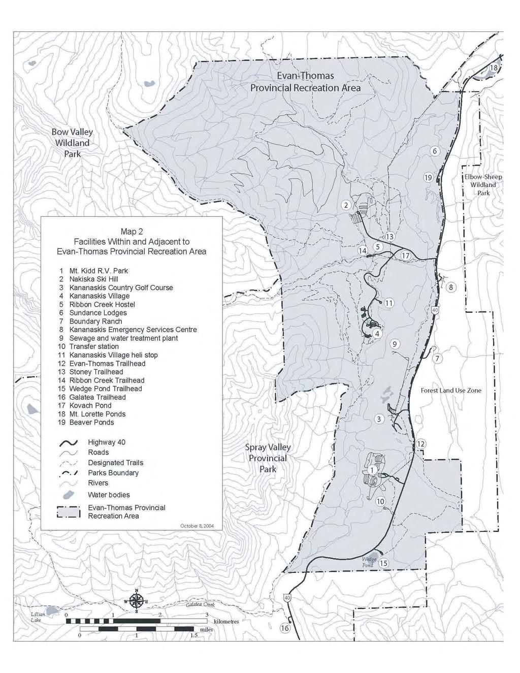
10 Sundance Lodges: Has 15 tepees, 15 trapper tents and 30 regular campsites for rent. A gift shop, groceries, washrooms, showers, coin laundry, camping supply & sports equipment rentals are also available. Staff are housed on site. B. Government Facilities Contracted to the Private Sector Nakiska Ski Area: Downhill ski facility with 230 acres of skiing on 28 runs, four chairlifts and one surface lift, snowboarding half pipe and cross track, snowmaking abilities, training facility, day lodge with food services and bar, mid-mountain lodge, ski shop and ski instruction. This 1988 Winter Olympic legacy also supports training for ski race teams. It also serves as a cross-country ski staging area with access to the nearby Ribbon Creek trail system. Staff housing at Kananaskis Village is shared with the Kananaskis Country Golf Course. A manager s residence is on site. Kananaskis Country Golf Course: Includes two 18-hole world-class golf courses (Mt. Kidd and Mt. Lorette), each with a capacity of 33,000 to 35,000 rounds per year, and a driving range. The clubhouse includes a dining room and fireside lounge while the pro shop is housed in a separate building. The Robert Trent Jones Pavilion caters to groups up to 300. A total of 33 residential housing lots exist within the Kananaskis Golf Course Sub-Division. These lots are leased to businesses in the Kananaskis Valley that meet the need to reside and other established housing guidelines. One lot is for provincial staff housing and two are leased to the federal government (RCMP). Eighteen lots are developed at this time. Mt. Kidd RV Park: Has 229 sites including 197 sites that are fully serviced. Two campground loops remain open year round. Amenities include a Camper Centre with lounge and snack bar, showers, laundry, washrooms, convenience store, tennis courts, equipment rentals, hot tub, wading pool, horseshoe pits, and volleyball. Staff housing is on site and includes a mobile home park for staff working in the Kananaskis Valley. Kananaskis Village Centre: Includes a public lounge/meeting room with a convenience store, post office, washrooms, gift shop, rental shop and public information centre. The nearby pond is used for skating in winter. This Centre, which is operated through a contract to the Delta Lodge, also serves as a public trailhead for access to Terrace Trail, Village Loops and the paved Evan-Thomas bike path. Beaver Ponds: Day use and picnic area near the north end of the Evan-Thomas Provincial Recreation Area with stocked fishponds during summer, walking trails, parking and seasonally available toilets. C. Government Owned and Operated Facilities Ribbon Creek Trailhead: Year-round day use site for picnicking, interpretive signs and access to Ribbon Creek trails. Kovach Pond: Summer picnic area and trailhead for paved Evan-Thomas bike path. Wedge Pond: This is a year-round day use area with picnic sites, a one km interpretive walking trail around a stocked fishpond and trailhead for the paved Evan-Thomas bike path. Stoney Trailhead: Small year-round parking area for access to Stoney Trail, Troll Falls, Skogan Pass and other area trails. Evan-Thomas Trailhead: year-round trail access to Evan-Thomas Valley with connection to Wedge Pond. Kananaskis Village Helistop: Located adjacent to Kananaskis Village, this facility is used for helicopter access to the village, sight-seeing, access to remote areas for heli-hiking, and research. 6
11
12 Trails: There are approximately 64 kilometres of official, maintained trails within the Evan-Thomas Provincial Recreation Area (see Map 2). Popular summer trails include the Evan-Thomas bike path, Ribbon Creek Trail and Terrace Trail. Short trails in proximity to the hotels (e.g., Village Rim Trail) see the highest use levels. Cross-country skiing and snowshoeing occur on approximately 60 km of groomed loops in the vicinity of the Kananaskis Village, Ribbon Creek and around Nakiska. The Ribbon Creek Trail accommodates both hiking and mountain biking up to kilometre 4.9. Use of mountain bikes beyond this point is not permitted. The Ribbon Creek Trail also provides hiking access to Buller and Guinn Pass Trails as well as the non-designated North Ribbon Creek Trail located in the adjacent Bow Valley Wildland Park. A spring closure (April 15 to June 15) is in place on the Mt. Allan Centennial Trail to protect bighorn sheep lambing areas. The Mt. Kidd RV Park Interpretive Trail is the only interpretive trail within the Evan-Thomas Provincial Recreation Area. Equestrian use is permitted on the Evan-Thomas, Stoney/Ruthie s/skogan Pass and Stoney trails. Terrace and Terrace Link in the vicinity of the Kananaskis Village are designated equestrian by permit with limited commercial equestrian use occurring (e.g., horse-drawn sleighs). There are several unofficial, random use trails within the Evan-Thomas, some of which are of concern because of their impacts on wildlife or habitat, or because of related erosion concerns (e.g., the nondesignated trails on the slopes of Mt. Kidd above the Kananaskis Village). Occasional conflicts between different users of a trail or area have been reported but this does not appear to be a large concern. A spring closure (April 15 th to June 15 th ) is in place for the Stoney Trail from the Hay Meadows Trail junction north to the Jewell Bay backcountry campsite located in Bow Valley Provincial Park. This closure accommodates spring elk calving and movement. While no rock or ice climbing occurs within the boundaries of the Evan-Thomas, access to several popular climbs on nearby lands is gained from parking areas within the Provincial Recreation Area. D. Facilities Adjacent to Evan-Thomas Kananaskis Emergency Services: located just outside the east boundary of the Provincial Recreation Area, this facility serves the Evan-Thomas and includes fire, police, rescue and emergency medical services. Boundary Ranch: Includes a riding stable, restaurant, two meeting/banquet facilities (80 and 320 persons). Program offerings include winter sleigh rides at Kananaskis Village, snow coach tours, rodeo demonstrations, corporate BBQs, horseback riding, and guided hunting and outfitting. This facility serves many visitors to the area and uses portions of the Provincial Recreation Area for horse-drawn sleighs and guiding and outfitting. 3.2 Visitor Use The Evan-Thomas attracts a large number of both overnight and day use visitors due to its proximity to Calgary, Canmore and Banff, the high quality natural and scenic values as well as the many facilities and recreation opportunities available. The hotels, hostel and campgrounds accommodate approximately 275,000 guest nights annually. There are an estimated 1.25 million day use visits annually to the various facilities within the Evan- Thomas. Popular activities include hiking, bicycling, golf, downhill and cross-country skiing, horse riding and picnicking. As well, there are up to five major special events (e.g., the Kananaskis 100-mile relay race) and several commercial filming events annually. Further, approximately 15 commercial operators offer guiding and instruction here in activities such as hiking, backpacking, horse tripping, cross-country skiing, dog sledding, fishing and whitewater rafting. 8
13 Use of the Evan-Thomas Provincial Recreation Area has increased since its initial development; however, statistics reveal that day use and camping varies from year to year, largely influenced by weather conditions during prime visitation periods. Use levels during a summer of mostly good weekend weather have been nearly 50% higher than the average. In low snow winters in the Rockies, Nakiska has enjoyed high use due to its reliable man-made snow. 3.3 Tourism / Commercial Recreation The Evan-Thomas Provincial Recreation Area is an important component of the tourism industry in Alberta. It is the primary area in Kananaskis Country where the development of a variety of permanent commercial recreation/tourism facilities has occurred. The economic effects of the investment made by the Alberta Government and the private sector in the recreation and tourism infrastructure are significant. To illustrate, the Delta Lodge at Kananaskis and the Executive Resort at Kananaskis combined to provide 180,000 visitor nights in 2000, Mt. Kidd RV Park has averaged approximately 95,000 visitor nights per year over the last ten years. Overnight use at the hostel and Sundance Lodges is estimated at 5,000 visitor nights per year. Skier visits to the Nakiska Ski Area have averaged 130,000 annually, while an average of 70,000 golfers have used the Kananaskis Golf Course each year. Alberta Transportation traffic counts indicate that approximately 800,000 vehicles travel this portion of Highway 40 each year, although the majority do not stop in the Evan-Thomas. Use levels in the Evan-Thomas are expected to rise. Contributing factors include the annual growth rate of the Calgary region which is the primary market for Kananaskis Country. The provincial population outside of the Calgary region, which is the secondary market for Kananaskis Country, is also growing. As well, the market for nature, adventure, outdoor recreation, culture, and learning vacations is increasing and Kananaskis Country is attractive for all of these. These visitors tend to stay longer and participate in more activities than most others. An additional factor is the growth in external markets for the Alberta tourism industry. Visitors from Canada, the United States, and overseas are increasing. Favourable exchange rates, ease of travel to the area, proximity to the Calgary International Airport, visitors looking for alternatives to Banff, and target marketing programs are all expected to contribute to the increase. Another factor is the current marketing program by local operators called Valley of Adventure Development Policies and Guidelines The following policies and guidelines apply to all facility developments within the Evan-Thomas Provincial Recreation Area: Kananaskis Country Recreation Policy, May 1999 This policy provides guidelines for future development throughout Kananaskis Country including the Evan-Thomas Provincial Recreation Area: No town-sites or permanent or non-essential residency will be permitted in Kananaskis Country. Adjacent communities will act as the service centres for Kananaskis Country. New, large-scale development proposals will be directed outside of Kananaskis Country. New facilities (small fixed-roof accommodation, camping) will be directed to nodes where possible. New proposals may be subject to a proposal call process. Where a proposal is within an existing lease, a proposal from the leaseholder may be entertained. New facilities will be limited to a maximum size of 15,000 sq. feet including accommodation and support buildings and cover less than three hectares. No second-home developments will be permitted; public land will not be sold in Kananaskis Country. No third party ownership or private/exclusive benefits will be permitted on leased land (e.g., condominiums, time-shares, etc). Total regional environmental effects must be avoided, managed or mitigated. 9
14 Kananaskis Country Architectural Theme Guide, Revised January 2001 This is a compilation of guidelines and criteria to be used by the Alberta Government and all development proponents in the preparation of designs for all visitor accessible buildings in Kananaskis Country including the Evan-Thomas Provincial Recreation Area. The intent of the guide is to ensure that buildings blend in with the natural environment and use an appropriate and consistent approach to form, colour and finish. It also helps to ensure that current codes and related requirements (e.g., FireSmart measures) are incorporated into the design. Alberta Tourism and Recreational Leasing Process (ATRL) The Alberta Government uses this process to review unsolicited tourism and recreational development proposals on public lands. Proposals for development within Kananaskis Country must first be reviewed from a policy perspective by the Kananaskis Country Interdepartmental Consultative Committee (K.C.I.C.C). If the proposal is consistent with all policies then a more detailed proposal is prepared and reviewed and this includes a public disclosure requirement. Also, if a proposed development in Kananaskis Country is likely to have more than one qualified applicant, a Call for Proposals may be used. Kananaskis Improvement District Land Use Order (July 15, 2002) Provides authority and direction for municipal planning and development control by Ministerial Order from the Minister to the Kananaskis Improvement District Subdivision and Development Authority. Proposed developments or alterations to existing facilities require that Development and/or Building Permits be issued prior to start of construction. Guidelines for applicants are provided in the Guideline to the Kananaskis Improvement District Subdivision and Development Permit Application Processes and the Subdivision and Development Appeal Process under the Kananaskis Land Use Order Community Facilities and Services Water Supply Potable water for the Kananaskis Village, Golf Course, Mount Kidd RV Park, Boundary Ranch and staff housing areas is provided by wells. Well water is chlorinated and pumped through the distribution system including a reservoir at the Kananaskis Village site. This system is operated and maintained by a contractor for Alberta Infrastructure and includes regular testing and reporting of results. The water supply system is adequate to meet required peak demands including sufficient flow for fire suppression. Nakiska is serviced by four separate wells, two pump houses, a reservoir and a distribution system. The Sundance Lodges and Ribbon Creek Hostel have individual water supply systems. Sewage Treatment All sewage generated from the major facilities and residences in the Evan-Thomas Provincial Recreation Area is piped to the Evan-Thomas sewage treatment plant located at the north end of the golf course. The plant is owned by Alberta Infrastructure and the operation is contracted out. It operates close to capacity during peak visitation periods. The plant is designed to accommodate some future expansions and upgrades through incorporating additional treatment modules. The Sundance Lodges and Ribbon Creek Hostel have individual sewage treatment systems. Electricity/Gas A 138 kv transmission line passes through and services the Evan-Thomas Provincial Recreational Area and Kananaskis Valley. An easement accommodates this line on Crown land. Additional capacity exists 10
15 in the supply to the Kananaskis Village and Nakiska. Some facilities have a back up diesel generator or emergency lighting in the event of a power failure. All facilities and housing in the Evan-Thomas are serviced with onsite propane tanks. A natural gas pipeline to facilities in the Evan-Thomas has been considered but not found to be cost effective to date. Solid Waste Disposal A domestic solid waste transfer station is owned by the Kananaskis Improvement District and operated by private contractor(s). Domestic solid wastes are collected, delivered to the waste transfer station and hauled to Calgary landfill sites. A dry waste disposal site exists within the Evan-Thomas Provincial Recreation Area for materials disposal and burial of construction material and debris. A burn pit also exists for burning clean combustible material. The ashes from the burn pit and from nearby campgrounds are buried on site. Opportunities for recycling concrete, asphalt, tires and metal are available at the dry waste disposal site. A topsoil storage pile also exists at the site. Future opportunities for composting are being investigated. Opportunities to recycle consumer goods are provided by the solid waste collection contractor at the maintenance yard at the Kananaskis Village. A hazardous/toxic waste round up is co-ordinated every two years by the Kananaskis Emergency Services staff. Communications Telephone service for the Evan-Thomas Provincial Recreational Area is provided by Telus. A fibre optic service was installed in The opportunity exists for a cable service provider to utilize the fibre optic facility to provide cable and Internet service to the area. Telus and Rogers own and operate three cellular telephone towers to provide cellular coverage in the area. Roads Alberta Transportation and Kananaskis Improvement District through their contractors, maintain and upgrade Highway 40 and the local roads. Leaseholders are responsible for developing and maintaining roads within their leases. Staff Housing Kananaskis Country policy prohibits the development of townsites and non-essential residency. Accordingly, housing within the Evan-Thomas is restricted to those actively working for one of the businesses, which holds a land lease with the province, or those government agencies with a need to reside. A variety of staff housing developments exist in the Evan-Thomas area. These include a singlefamily residential subdivision adjacent to the golf course, a mobile home park adjacent to Mt. Kidd RV Park and four apartment style buildings adjacent to the hotels. The Golf Course Subdivision includes 33 lots. The mobile home park at the Mt. Kidd site presently consists of 30 lots with an additional 33 lots approved. Village staff are housed in four apartment style buildings near the hotels. There are four undeveloped vacant lots at this site. Essential staff of the Hostel, Sundance Lodges, Nakiska ski hill and Mt. Kidd are accommodated on site. Emergency response crews are accommodated when necessary adjacent to the Emergency Services Centre. 11
16 Kananaskis Emergency Services Kananaskis Emergency Services Centre (KESC) provides coordinated fire/rescue and emergency medical services to the visitors, residents and employees in the Kananaskis Valley and adjacent areas. The centre is located just south of the Highway 40 turn off to the Kananaskis Village on the east side of Highway 40. Kananaskis Emergency Services activities are co-ordinated with the RCMP, Alberta Sustainable Resource Development, Conservation Officers and neighbouring jurisdictions. Alberta Community Development is responsible for backcountry safety and rescue. Law Enforcement The RCMP detachment for the Kananaskis, Highwood and Spray valleys is located adjacent to the Kananaskis Emergency Services Centre and has been operational since the 1988 Olympic Winter Games. Wildfire Response The Forest Protection Division of Alberta Sustainable Resource Development provides forest fire detection and responses for all of Kananaskis Country including the Evan-Thomas. A fire base used on an occasional basis is located near the Kananaskis Emergency Services Centre. Increasing attention is being given to forest fire hazard risk reduction in forested communities of Alberta and some inventory work has begun in the Evan-Thomas. Flood Risk and Mitigation Floods and flooding caused by winter ice jams have damaged the golf course and threatened its associated buildings. This is also a concern at the Mt. Kidd RV Park as well as the Evan-Thomas Water and Wastewater Treatment Plant. Considerable work has been done by the province to identify flood risk and mitigation alternatives along the Kananaskis River particularly through the golf course area. Various measures such as flow reductions (by Trans Alta Utilities), construction of free span bridges, dykes, and channel modifications have been implemented. Other measures include ongoing emergency ice removal and fisheries habitat enhancement work. Other Services Other existing services include a small grocery/convenience store in the Village Centre, sports equipment rentals, a skating and hockey rink near the hotels, a sports field and limited health services provided by the ambulance operator. Many other recreation and community services are provided in Canmore or other nearby centres. Kananaskis Improvement District (KID) is the municipal authority for Kananaskis Country. Kananaskis Improvement District works with Alberta Community Development and other departments in the provision of infrastructure and services to the area. The Kananaskis Community Association has recently been formed with a view to improving the recreational and other community focused opportunities for residents of the Evan-Thomas. 3.4 Natural Features Geology/Landforms The underlying bedrock of the Evan-Thomas area includes Devonian limestones, dolomites, siltstone and shales along with some coal layers. Outcrops of Triassic and Jurassic siltstone, conglomerate and sandstone are also found here. No notable fossil features are known in this area. The area is underlain by a large syncline (large U shaped fold) and evidence of folding and faulting is visible especially on adjacent Mt. Kidd. Bedrock outcrops occur along ridgetops and along Ribbon Creek while the majority of mountain slopes are composed of colluvial materials. 12
17 The Kananaskis Valley has been shaped by glaciation with the most prominent features being morainal terraces that occur along both sides of the valley just above the floodplain. The Kananaskis River, Evan- Thomas and Ribbon Creek floodplains are prominent alluvial features within the Evan-Thomas Climate The Evan-Thomas area is in a transition between Continental and Cordilleran (mountain) climate types with moderate precipitation in both summer and winter (56% as rain and 44% as snow) and moderate temperatures. Climate records have been kept in the vicinity since 1939 at the Kananaskis (Boundary) Ranger Station as well as the nearby research centre at Barrier Lake and in Marmot Basin (Mt. Allan) during a decade-long watershed study in the 1960 s (see Janz and Storr, 1977). The annual temperature profile follows a typical pattern for this latitude, with the lowest average temperatures in January (-6 C), and the highest in July (14 C). The average annual precipitation increases from mm at 1400 m (valley bottom) to mm at 2400 m, based on an eight-year study at Marmot Basin. May and June are the wettest months and the highest average snowfall occurs in March and April. Prevailing winds are westerly and southwesterly and, high on the Mt. Allan ridge, chinook gusts of over 200 km per hour have been recorded Fisheries A variety of fish species are present in the permanent streams and some ponds within the Evan-Thomas. The native sport fish community in the Kananaskis River likely consisted of mountain whitefish, bull trout and westslope cutthroat trout. These fish, with the exception of the whitefish, are almost completely gone from the system and non-native brown trout and brook trout have taken over as the dominant species. A few rainbow, cutthroat and bull trout are also present. There is ongoing work to improve fish habitat in the section of the river adjacent to the Kananaskis Golf Course and sewage treatment plant. This work has included construction of groynes and spurs within the main stem of the Kananaskis River as well as the re-opening of several side channels. The intent is to meet the no-net-loss goal of fish habitat set out in the Alberta Fish Conservation Strategy and the Federal Department of Fisheries and Oceans Guidelines. Fisheries inventory work undertaken in the summer of 2001 found that Evan-Thomas Creek contained a good population of native westslope cutthroat trout along with some brook trout. Ribbon and Galatea Creeks historically had native westslope cutthroat trout and probably bull trout as well. The lakes that these creeks drain are stocked with native westslope cutthroats on a two-year schedule and it is possible that some of these fish could be found in the creeks. The beaverponds adjacent to the Kananaskis River near Sundance Lodges are also stocked with native westslope cutthroat trout on a two-year schedule. Whether fish are present in tributaries north of Ribbon Creek is not known at present. Wedge Pond, in the southeast corner of the area has had a stocked population of Arctic Grayling since Monitoring in 2001 revealed that this population is self sustaining to a degree, which has allowed a reduced rate of restocking. The present regulations for Wedge Pond are catch and release and a bait ban. The pond at the Kananaskis Village is stocked yearly with rainbow trout (> 25 cm) for the summer period only. Brook trout are found in substantial numbers within the ponds scattered throughout the Kananaskis Golf Course Vegetation The Evan-Thomas Provincial Recreation Area contains areas of montane, sub-alpine and alpine ecoregions. A small area of transitional montane characterized by mixed wood forest and small open grasslands can be found along the Kananaskis River in the north end of the recreation area. Dominant tree species found in this area include trembling aspen, lodgepole pine and white spruce. Some patches of Douglas Fir are also found here. The Kananaskis River and several small willow dominated wetlands along the river provide important riparian habitats not found elsewhere in the Provincial Recreation Area. Several small grasslands can also be found here. The largest portion of the Evan-Thomas lies within the sub-alpine area and includes forested slopes. Dominant tree species include Engelmann spruce, white spruce, lodgepole pine and sub-alpine fir. 13
18 Several pockets or patches of alpine larch can also be found in Marmot Basin above 2000 m. elevation. Numerous avalanche paths can be found along slopes on the western side of the PRA and contain a high diversity of plant species. The alpine area is typically located above 2260 m. in this region and is restricted to areas on the western edge of the Evan-Thomas. This area is characterized by open alpine meadows, steep slopes, exposed rock or scree slopes with small tree islands consisting of alpine fir. A number of sensitive or rare vegetation species found in the Evan-Thomas are being tracked by the Alberta Natural Heritage Information Centre (ANHIC). The majority of these are either in the north end of the Provincial Recreation Area or in Marmot Basin. Most notable of these species is the moss Mielichhoferia macrocarpa found near Troll Falls and the cinquefoil Potentilla macounii found on the slopes of Mt. Allan. Disturbance has been a common occurrence in the forests of the Evan-Thomas Provincial Recreation Area over the last 200 years, shaping forest composition and ecological diversity. Forest fires and logging have been the main disturbances, and have affected most of the valley bottom and lower slopes. Logging has been carried out for various purposes including forest products, watershed research, habitat improvement, and clearance for utility corridors and downhill skiing. In spite of these disturbances, most of the forest has regenerated, and only five percent of the Provincial Recreation Area contains man-made forest openings. Development also has impacted the original vegetation. About three percent of the Provincial Recreation Area has been developed for roads, parking areas, campgrounds, golf course, hotels and related infrastructure. Access trails have been developed through much of the Provincial Recreation Area for walking, bicycling and cross-country skiing. Nakiska ski hill, the Kananaskis Golf Course and the Hay Meadows area below Nakiska contain a mix of natural and introduced grasses as a result of clearing and/or reclamation. Additional information on historical vegetation change in Evan-Thomas Provincial Recreation Area is found in Appendix C. Wildfire is a natural disturbance, however forest fires are highly unpredictable and large wildfires may threaten human life, safety and development. The type and arrangement of forest fuels in the Kananaskis Valley creates the potential for large wildfires that may threaten existing recreational and tourism developments in the Evan-Thomas Provincial Recreation Area. Factors that influence the risk level include the location and type of development, construction materials and design, proximity to natural forest fuels, the type and condition of forest vegetation, location of combustibles and slope. A formal wildfire risk assessment and plan has not yet been completed for the Evan-Thomas Provincial Recreation Area. A variety of forest insects and diseases are found or may occur within the Evan-Thomas Provincial Recreation Area. These are subject to ongoing monitoring by the province and, depending on the threat, may be subject to a variety of control measures. Within protected areas like the Evan-Thomas, measures that result in the least disturbance may be used to reduce the threat. These include removal or treatment of individual affected trees; small scale, selective removals; and in these cases, there must be careful coordination with recreation and wildlife factors, etc. Mountain pine beetle is considered to be an irregular forest pest in Alberta, depending on a number of factors including winter temperatures. However, the Government of Alberta is concerned about the threat of beetle outbreaks because of recent significant population increases in British Columbia and Banff National Park. Many of the pine stands in Evan-Thomas Provincial Recreation Area and Kananaskis Valley are considered high risk for beetles due to their advanced age. The main concerns associated with a large scale beetle outbreak here include the possibility of spread to commercially valuable pine stands elsewhere in Kananaskis Country and the increased forest fire risk if large numbers of dead trees result from an outbreak. Monitoring for pine beetle will occur as necessary. 14
19 Much of the lower elevation forest in the Evan-Thomas is even-aged lodgepole pine that regenerated after widespread logging in the early 1900s or after a 1936 forest fire. The average fire interval in the valley bottom and lower slopes has been 150 years, so the age of the forest today is still relatively young. However, further intervention may be considered to create a multi-aged forest as opposed to allowing the entire even-aged forest to grow older. Intervention could include selective stand-replacing disturbances such as prescribed fire or selective tree cutting. The benefits could include the creation of younger stands that are more resistant to insects and disease, increasing the diversity of habitats available for native plants and animals and improving scenic qualities Wildlife The planning area is significant for wildlife from a number of perspectives. Large areas of high quality habitat within and adjacent to the Evan-Thomas Provincial Recreation Area meet the spatial and temporal requirements for a large diversity of wildlife species with some species occupying the area in significant numbers. In addition to seasonal and year-round habitats, the Evan-Thomas area serves as an important movement corridor for locally and regionally important wildlife species. The slopes of Mt. Allan, both within and outside the Evan-Thomas PRA, have large tracts of alpine and subalpine habitat, and support the largest bighorn sheep herd in Kananaskis Country which numbers around 300 animals. The south and southwest facing slopes are critically important winter ranges for this herd as these slopes tend to remain snow free for much of the winter. Several lambing areas are also known on Mt. Allan which require protection from human disturbance at critical times. Many of these sheep migrate through the Evan-Thomas area in the spring particularly along the slopes below the former fire lookout on Mt. Kidd. The valley bottom along the Kananaskis River (in the Evan-Thomas) supports a wintering elk population of approximately 60 to 80 animals. This population has slowly been increasing over the last 10 years and also has become less migratory. The Kananaskis Golf Course provides excellent winter range and numbers of elk there have increased. During spring, summer, and fall, the slopes of the Nakiska ski area provide good foraging opportunities for elk. The upper slopes of Nakiska and the adjacent Marmot Basin area are especially important for elk in the fall. An unknown proportion of these elk remain year round in the valley and individuals are known to calve in the area. Through periodic surveys, the benchland slopes to the west of the Kananaskis River and below Mt. Kidd have also been identified as important winter and summer range. In addition to elk, deer (mule deer and white-tailed deer) and moose are also found in the planning area but numbers are unknown. Large carnivores such as grizzly bears, black bears, cougars, wolves, and coyotes utilize the Evan- Thomas area but exact numbers are unknown. The Peter Lougheed wolf pack has used the Kananaskis Golf Course on numerous occasions and is known to have made ungulate kills in the area. Both species of bears are regularly observed in the area and radio tracking has identified a minimum of five different grizzly bears that used the Nakiska ski slopes during summer of The Eastern Slopes Grizzly Bear Project (ESGBP), started in 1994, has collected valuable information on the population status, demographics, distribution, and habitat use by grizzlies. The open slopes of Nakiska, parts of Marmot basin and the open slopes above the Kananaskis Village hotels provide good foraging opportunities for bears during spring, summer or fall. During the berry season (late summer and early fall), bears make heavy use of lower elevation areas near the hotels, the golf course and the lower slopes of the Nakiska ski area in search of buffaloberries. Following the berry season, bears move to higher elevations and appear to prefer the upper slopes of the ski hill and the slopes above the Kananaskis Village hotels. Many other smaller carnivore species such as marten, mink, weasels, skunks, and lynx are known to use the area but there is little detailed knowledge on their numbers and distribution. Wildlife-human conflicts are known to periodically occur in the Evan-Thomas area. Grizzly bears, black bears, and coyotes have been involved in these incidents. 15
20 Harlequin ducks are a species of concern in Alberta and are known to breed along the Kananaskis River in small numbers. Recent research has been conducted into their breeding status, distribution, and ecology. The Kananaskis River Valley is an important movement corridor for ungulates and large carnivores. The Evan-Thomas planning area is important in maintaining regional connectivity between areas in southern Kananaskis Country, through Wind Valley into the Bow River Valley and beyond to Banff National Park. Tracking of radio-collared wolves and grizzly bears has documented movements through the planning area and has been useful in identifying some movement patterns. In addition, winter backtracking sessions of wolves identified movement areas such as the lower slopes of Mt. Kidd just west of the Kananaskis River. Hunting is permitted in the northwest corner of the Evan-Thomas subject to regulations and measures specified under the Wildlife Act Historical/Cultural Resources The first known human habitation of the Kananaskis Valley took place about 8,000 years ago. Numerous prehistoric sites are located along the Highway 40 right-of-way. Prehistoric artifacts indicate a more or less continuous use over the last 7,000 years at the Eau Claire campground, which is just south of the Evan-Thomas. Archaeologists suspect that people from as far away as Idaho travelled and lived in the valley during summer periods. Aboriginal peoples from British Columbia (probably Kootenai and Salish) frequently travelled through the area on trading missions with plains tribes. Stoney peoples have used the area in a variety of ways since their arrival in the 1600s. Mt. Kidd and Wedge Mountain have been used as vision quest sites and the southern portion of the Evan-Thomas area as a medicinal herb and ceremonial plant-gathering site. It continues to be used for this purpose as well as for the gathering of buffaloberry and mushrooms for consumption. In the mid-1800s European exploration of the area began with James Sinclair. John Palliser conducted scientific expeditions into the region, and others passed through the valley on their way to the Pacific Coast. The Eau Claire Lumber Company established logging camps in the area during the late 1800s. Timber was floated down the Kananaskis River to the Bow River and then on to mills in Calgary by Three major forest fires (1910, 1919, and 1936) damaged the timber resources eliminating the industry from the area. George Dawson of the Geological Survey of Canada conducted the first geological studies of the area between 1881 and 1884, and detailed studies in 1903 discovered coal in the Ribbon Creek area. In 1947 the Brazeau Colleries Ltd. developed a coal mining operation at Mt. Allan. Up to 150 men worked the mine and trucked the coal to the railway in the Bow Valley. The mine was closed in 1952 due to declining markets. In 1976 the Alberta Government announced a policy to prohibit coal mining in the area. The old town site of Kovach and the reclaimed mine on Mt. Allan are all that remain of this period in the history of the area. Interpretive signs describe these activities. The Canadian Forest Service used Marmot Basin as a watershed study site for many years after the Second World War. In 1988 the alpine events of the Winter Olympics took place on Mt. Allan. In June of 2002, the G8 Summit occurred at the Kananaskis Village. 3.5 Heritage Appreciation Major interpretive and educational themes for the Evan-Thomas area include aboriginal use, the logging and coal mining history, early forest management, Marmot Basin watershed and forestry research, 1988 Winter Olympic legacy, eagle flyway, wildlife and forest fire history. Other themes in the vicinity include the prisoner of war camp near Barrier Dam and the University of Calgary Field Station. 16
21 Environmental education services for students and other groups also take place throughout the Evan- Thomas area, keyed to issues and topics relevant to the Alberta Learning curriculum. 4.0 MANAGEMENT INTENT AND OBJECTIVES The following intent and objectives reflect the important natural, scenic, recreation and tourism values within the Evan-Thomas Provincial Recreation Area. The Management Intent is: To preserve and protect natural heritage while providing opportunities for sustainable outdoor recreation, heritage appreciation or tourism, or for any combination of those purposes which are dependent on and compatible with the natural environment. The Management Objectives are: Preservation: to preserve alpine, subalpine, montane and riparian habitats especially critical wildlife ranges, movement corridors and rare and endangered species, and ensure that natural ecological processes are maintained. Heritage Appreciation: to provide opportunities for visitors to experience, understand and appreciate the natural resources of the Evan-Thomas. Outdoor Recreation: to provide opportunities for visitors to enjoy non-motorized, low-impact day use activities such as hiking, mountain biking, equestrian use or cross-country skiing; as well as to experience world-class golf, downhill skiing, camping, and hotel and hostel accommodations. Tourism: To provide opportunities for visitors to experience and enjoy high quality natural and scenic qualities through the provision of a range of appropriate, sustainable tourism facilities and services. 5.0 BOUNDARY AMENDMENTS To enhance the protection of high wildlife habitat, riparian and scenic values, two areas in the south and west of the Provincial Recreation Area have been added to the Spray Valley Provincial Park. A third area on the north end of the Provincial Recreation Area has been added to Bow Valley Wildland Park (see Map 3). In total, 43 percent of the Provincial Recreation Area (1,849 hectares/4,569 acres) is receiving increased protected area status. In view of the close relationship between the Kananaskis Emergency Services Centre and the rest of the Evan-Thomas Provincial Recreation Area, and to facilitate approval of any future upgrading or expansion that may be required to provide adequate service to the community and visitors, a 10 hectare (24 acre) parcel of land in the immediate vicinity of the Emergency Services Centre has been added to the Evan- Thomas Provincial Recreation Area (see Map 3). 17
22 6.0 ZONING Consistent with the management intent and objectives for the Evan-Thomas Provincial Recreation Area and in order to strike the appropriate balance between resource protection and use in its different parts, a protected area zoning scheme has been applied. This scheme is described in more detail in Management Plan Format: Provincial Parks, Wildland Parks, Recreation Areas, Wayside and Access sites, Wilderness Areas, Natural Areas which is included in the List of References. The Provincial Protected Area scheme includes seven candidate zones of which three (plus one proposed sub zone) have been applied in the Evan-Thomas (see Appendix A). The different zones recognize the differences in resource values as well as visitor use and landscape capability in different parts of the Provincial Recreation Area (see Map 3). Those areas in the immediate vicinity of existing facility developments have been zoned Facility. Where possible future expansion potential exists, an effort has been made to include sufficient land area to accommodate this. The Nakiska facility zone is restricted to the developments at the base of the hill and does not include the lifts, runs or mid-mountain lodge. Possible new facilities at the base of the ski hill would be accommodated as expansions of existing buildings or, as one or more new separate buildings located on or adjacent to already developed land within the Facility zone. Proposals for one new, smallscale (less than 15,000 square feet) fixed-roof visitor accommodation facility may be considered adjacent to the south edge of the Nakiska facility zone in the area marked Possible Future Development. The existing ski runs, lifts and mid-mountain lodge and any approved future changes to them would be accommodated in the Recreation zone. This is intended to accommodate the intensively managed recreation facilities (e.g., runs, lifts) while recognizing the high summer wildlife habitat values. The area to the north of the existing ski runs that may be considered for future expansion of the runs and lifts is identified on Map 3 as Boundary of Potential Ski Area Expansion. Similarly, the area in the immediate vicinity of the golf course clubhouse, parking lots, etc. have been zoned Facility, while the fairways, cart paths, etc. have been zoned Recreation. Like the ski hill, this recreation zoning recognizes the importance of the intensively managed recreation (golf) facility as well as the important winter wildlife habitat values. The Facility zone around the Kananaskis Village includes room for possible future expansion of existing facilities. No more than two new small-scale (less than 15,000 square feet each) fixed roof accommodation facilities will be considered in the area marked Possible Future Development in the vicinity of the Village on Map 3. A Facility zone has also been applied to the immediate area of the Kananaskis Emergency Services Centre, which has been added to the Evan-Thomas Provincial Recreation Area. A Natural Environment zone has been applied to the loop trails area near the Kananaskis Village and the paved bike path through the Evan-Thomas (see Map 3). This recognizes the less intensive, but year round, trail recreation that occurs on these high standard trails as well as the important wildlife habitat values found here. Preservation zones have been applied to those portions of the Evan-Thomas that are known to be important as wildlife habitat (e.g., sheep winter range, spring bear habitat, elk calving) or movement corridors, having sensitive or rare species, rich biodiversity or flood prone riparian areas (see Map 3). 18

23
24 7.0 MANAGEMENT GUIDELINES 7.1 Outdoor Recreation Roads/Parking Maintenance and minor upgrading of existing roads and parking areas will be done as required, and as resources permit. No new roads are anticipated other than short access roads required to serve potential approved new facilities. Development of such roads will be the responsibility of the proponent. Trails If impacts or conflicts on existing designated trails become a concern, they will be considered on a caseby-case basis to determine the most appropriate management response subject to adequate resources being available. Options include upgrading, relocation, visitor information/education, temporary closures or other appropriate measures. Bicycle and equestrian use will be restricted to trails designated for those purposes. Hiking and mountain bike use will be accommodated on most designated trails within the Provincial Recreation Area, however, bicycles are not permitted on the Mt. Allan Trail due to steep grades. Equestrian use is accommodated on Stoney and Skogan Pass Trails as well as on trails east of Highway 40. Alberta Community Development will work with trail users and local operators to involve them in decisions about trail management. To curtail random trail use, the creation of new trails may be considered if the environmental impacts are acceptable. Alberta Community Development will undertake an inventory and assessment of existing undesignated (random use) trails and related sites with assistance from volunteers in the near future. Existing random trails and sites within the Evan-Thomas Provincial Recreation Area may be left alone, designated, or closed and reclaimed depending on environmental and aesthetic considerations. Monitoring of use levels and impacts on undesignated trails will be done as time and resources permit. While protection of important or sensitive habitat or species will receive priority, every effort will be made by Alberta Community Development to maintain a variety of appropriate and high quality trail recreation opportunities within the Evan-Thomas Provincial Recreation Area. Trail or area closures will be conducted under the authority of the Provincial Parks Act for public safety or to protect significant ecological and aesthetic features (e.g., spring closure of Mt. Allan Trail for spring lambing). Where temporary trail closures are necessary (e.g., due to bear hazard), users will be redirected to other nearby trails whenever possible. Such restrictions shall apply to all users and the rationale for closures will be communicated to operators and visitors. Alberta Community Development will work with business operators, other stakeholders and visitors to inform them of the various responses to public safety or impact situations, to communicate changes in status and seek their assistance in informing staff and visitors. Good communication mechanisms will be established for residents, local businesses and the public-at-large. Camping Expansion or upgrading of existing campgrounds at Mt. Kidd RV Park and Sundance Lodges may be considered within existing lease areas consistent with lease intent and the Kananaskis Country Recreation Policy, No new campgrounds will be considered in the Evan-Thomas Provincial Recreation Area. No random camping will be permitted and no backcountry campsites are planned within the Evan- Thomas Provincial Recreation Area, as all of it is easily accessible on a day use basis. Any random campsites found will be reclaimed. No fires will be permitted except in vehicle access campgrounds where firepits are provided. 20
25 Special Events Special events involving large groups of people (such as the Kananaskis Country 100 Mile Relay and other competitive events) and filming activities will continue to be considered in the Evan-Thomas Provincial Recreation Area. Activities that are non-motorized, dependent on a natural or wilderness-type setting, do not detract from the natural beauty and aesthetics of the valley and have acceptable environmental and social impacts will be considered. Permits will be issued under the authority of the Provincial Parks Act and consistent with the Kananaskis Country Special Events Guidelines, December 2000 or as amended. Some examples of activities that will not be permitted include off-road recreational vehicles (OHVs), snowmobiles and jet boats. Conditions on permits will include limits on size of events, duration and/or frequency so as to limit the impacts of these activities on the environment and other users of the area. The impacts of group use on the area will be monitored and if problems are noted, measures such as site hardening, user information and education, reclamation or relocation will be considered. Public consultation will occur prior to implementing such measures. 7.2 Heritage Appreciation The Barrier Lake Visitor Information Centre will continue to provide personal information services that include travel counselling and over-the-counter and telephone information on trails, safety, recreational opportunities, special events, and regulations that pertain to the Evan-Thomas. The Friends of Kananaskis Country Cooperating Association will continue to operate a bookstore service for the public visiting the Centre. Hiking trail maps and information brochures dealing with visitor safety, recreation opportunities, and special natural features will be available at the Centre. Personal interpretive services will be offered at Mt. Kidd RV Park on a scheduled basis. Special events may be held at various times of the year, such as Parks Day, when Kananaskis Country interpreters will lead small groups on guided hikes within the area. Interpretive trails and signs are currently in place at Mt. Kidd RV Park, Ribbon Creek day use area, the pull-off along Highway #40 and at Wedge Pond. Additional signs and/or exhibits may be placed near special features in high public use areas as resources permit. The private sector will be encouraged to provide new formal interpretive opportunities associated with the Kananaskis Village Centre and potential summer use at Nakiska. Use of the Evan-Thomas area for environmental education will be encouraged by providing local schools with trail and other educational information. Alberta Community Development may offer teacher and youth group leader workshops. Teaching units may be developed using specific areas as teaching sites. These sites will be selected by departmental staff and will be consistent with the provisions of this plan. 7.3 Tourism and Commercial Recreation Expansion or Upgrading of Existing Facilities As regional and provincial populations increase or as new demonstrated needs emerge, it is possible that additional recreation and tourism facilities may be desired within the Evan-Thomas. In considering additional facilities, an appropriate balance will be maintained between natural values; public access and enjoyment; and appropriate, viable business opportunities. Any proposals for expansion or upgrading of existing facilities or development of new, small scale facilities will be reviewed for consistency with the Provincial Parks Act, the intent of the Kananaskis Country Recreation Policy, 1999, the Kananaskis Country Architectural Guidelines (including FireSmart Guidelines) and the intent of any existing lease agreement. 21
26 Proposals will be considered for expansion or upgrading of existing facilities brought forward by the lessee of up to 20% of the existing building floor area (up to 15% for the Delta Lodge at Kananaskis and the Executive Resort at Kananaskis), and a maximum building height that is compatible with existing buildings. As well, any proposed expansions must be based on clearly demonstrated need, and be consistent with the lease intent and the provisions of the Kananaskis Country Architectural Guidelines revised January Up to two new small-scale fixed-roof visitor accommodation facilities (of not more than 15,000 square feet each) occupying up to three hectares (7.4 acres) of land each will be considered adjacent to the Kananaskis Village in the area marked Possible Future Development on Map 3. This site is near existing access and services and would concentrate any limited future development to an area that already experiences considerable human presence. Any development proposals must consider their potential impact on: the natural environment, other businesses, the supporting infrastructure such as water and sewer, as well as municipal services. Proponents will be requested to incorporate environmentally friendly technologies into their developments. Any development proposals must clearly demonstrate need, and will be subject to the approval of the Kananaskis Country Interdepartmental Consultative Committee (KCICC) as authorized by the Kananaskis Improvement District (KID) Land Use Order (2002). Kananaskis Country Golf Course Any proposals for upgraded or expanded facilities must be located within the existing lease, be consistent with the current intent of the lease (provision of high quality, accessible, public golf opportunities), and have acceptable environmental and social impacts. Facility design will be consistent with the Kananaskis Country Architectural Guidelines (revised January 2001). Nakiska Ski Hill Proposals for upgrading or redevelopment of existing downhill ski facilities/opportunities within the existing lease area will be considered. New potential summer use will be considered and will be restricted to ski lift-assisted viewing, interpretation or environmental education. Such activities will occur in the vicinity of the mid-mountain lodge, and will be part of an operating plan that will be reviewed annually to ensure that public safety is maintained and environmental (especially wildlife) conflicts are minimized and mitigated. Camping and mountain biking will not be allowed as summer activities at Nakiska. Public use of Skogan Pass and other designated summer trails in this vicinity will continue consistent with the management intent in this plan. At the base of the Nakiska Ski Area, one small-scale (no more than 15,000 square feet), fixed-roof visitor accommodation facility occupying up to a maximum of three hectares (7.4 acres) of land will be considered. Any proposed new development will utilize already disturbed areas or small areas immediately adjacent to existing parking lots, roadways or buildings. Any new development proposal must clearly demonstrate need, and will be consistent with the Kananaskis Country Recreation Policy. Future expansion of the ski area into the area labelled Potential ski area expansion (see Map 3) will be considered, to address future increased visitor demand. In this event, the proponent will have to demonstrate that there is clear increased visitor demand for expansion and that environmental and social impacts are acceptable. 22
27 Kananaskis Village The Village consists of two hotels, the Village Centre building, staff housing, maintenance area and other associated facilities. Proposals from existing lessees for upgrading or expansion, based on demonstrated need, will be considered within the Village Facility zone (see Map 3). An expansion of up to 20% of the existing floor area of the Village Centre by the private sector to provide additional retail and interpretive services will be entertained. Proponents will have to demonstrate that environmental and social impacts are acceptable. Helicopter Use Helicopter use will continue to be permitted subject to the Voluntary Helicopter Guidelines for the Canmore/Kananaskis Area, December The Kananaskis Village Helistop will continue to operate under existing Department of Transport requirements and Kananaskis Country guidelines, which are intended to minimize the impacts on wildlife and other visitors. 7.4 Community Facilities/Services Utilities Alberta Community Development will continue to work with Alberta Infrastructure, Alberta Environment, Kananaskis Improvement District and leaseholders to maintain or enhance existing utility infrastructure. This includes the maintenance and operation of the water and sewage system according to the latest standards and guidelines. While existing systems are adequate for existing demands, any new proposed developments or increased demands on these systems will require a review. If expansion of existing plants is required, proponents of any new developments will be required to pay these costs. Natural gas service to the Evan-Thomas will be considered if a qualified proponent makes a request and if economic factors are acceptable to leaseholders and the province. No new power transmission rights-of-way will be permitted in the Evan-Thomas. Local power distribution corridors required to service existing or possible new development will be considered using underground installation only. Emergency Services Structural fire fighting capability in association with capacity of the water supply and treatment system is to be confirmed before any additional buildings are developed in the area. The Kananaskis Improvement District Municipal Emergency Preparedness Plan will be updated as required if the transportation of dangerous goods (particularly propane and gasoline) increases. Emergency response plans will be updated regularly by the Departments of Sustainable Resource Development and Community Development as well as Kananaskis Emergency Services. Concerns such as alternate emergency access routes and access to water source areas will be considered in emergency response plans. Powerline rights-of-way will be managed to reduce fire risk. The departments will encourage public awareness through various programs including open houses, newsletters and webpages. The publication FireSmart contains detailed advice on how to reduce the risk of loss and enhance safety in forested areas, and is available at Alberta Sustainable Resource Development offices and the website Staff Housing Applications by eligible businesses to develop any additional staff housing will be subject to the clear need to reside condition (and other provincial policies respecting staff housing), the availability of serviced lots, spare capacity at the water and sewage treatment plants, the Kananaskis Country 23
28 Architectural Guidelines (revised January 2001), and minimizing any negative impacts on the natural environment. The use of FireSmart guidelines will also be encouraged. An area of no more than three hectares (7.4 acres) will be permitted for possible additional staff housing at the Mt. Kidd subdivision (see Map 3), as demand warrants. Staff of the Mt. Kidd RV Park, the hostel and Sundance Lodges will continue to be accommodated on site, subject to the need to reside condition. Existing limited staff housing will continue to be accommodated at Nakiska. Community Centre and Services Recent consultations with residents have identified several measures that may improve the sense of community and quality of life for residents. Alberta Community Development will discuss the needs of the community with Kananaskis Improvement District and the local community association. 7.5 Preservation Geological/Landforms There is little risk of disturbance to existing bedrock outcrops within the Evan-Thomas area as they are few in number, small in size and do not attract much visitor activity. Quarrying and mining is prohibited by the Provincial Parks Act and provincial government policies related to Kananaskis Country. Any disturbance due to trail use will be kept to a minimum. Additional facility development on the floodplains within the Evan-Thomas will be limited to minimize further flood risk and damage to facilities. The interpretation of local geology and landforms will be addressed by interpreters as well as guides and outfitters operating in the area Fisheries Fish resources will continue to be managed following the guidelines set out in the Alberta Fish Conservation Strategy with an emphasis on native fisheries where possible. Fishing will continue to occur subject to regulations and limits under the Fisheries Act. The protection of fish habitat will follow the Federal Department of Fisheries and Oceans no-net-loss policy as well as the appropriate code of practice for work within watercourses set out by the Alberta Government Vegetation Protection of key montane and riparian habitats and wetlands along the Kananaskis River, particularly north of the Kananaskis Village access roads, will be a high priority and these areas have been zoned Preservation. Further development and increased human use in these areas will be discouraged. Trail and facility development will be directed away from avalanche slopes and run out zones, which provide high quality seasonal habitat for a number of wildlife species. Buffaloberry is an important seasonal food for grizzly bears and will be managed to reduce potential conflicts between bears and people while continuing to provide high quality habitat. This will include the control or removal of this shrub around trails and facilities and encouraging its growth in areas away from high human use Wildfires All wildfires in and adjacent to the Evan-Thomas Provincial Recreation Area will be suppressed according to provincial wildfire suppression policy. All wildfires will be extinguished at spot size to prevent escaped fires from becoming large fires. 24
29 Forest vegetation immediately near developments and structures may be selectively removed or thinned to minimize the risk posed from wildfire. Such measures will be implemented following an approved plan by the Departments of Community Development and Sustainable Resource Development, and after consultation with key stakeholders and the public. Fuel removal techniques that minimize disturbance to the natural environment will be used, while considering aesthetics and recreational values. Further, to help protect buildings, the Departments of Community Development and Sustainable Resource Development, along with Kananaskis Improvement District will encourage the application of FireSmart building guidelines. Emergency response plans will be updated regularly. Measures such as emergency access routes and access to water source areas will be considered in reviewing any future facility development proposals. As well, the fire risk on powerline rights-of-way will be maintained at acceptable levels. Adequate space will be maintained around fuel and propane tanks. Public awareness of fire hazards will be encouraged through various programs including open houses, newsletters and webpages. The publication FireSmart contains detailed advice on how to reduce the risk of loss and enhance safety in forested areas, and is available from Alberta Sustainable Resource Development, Kananaskis Improvement District and Alberta Community Development, Kananaskis Country offices. Forest insect and disease epidemics that threaten adjacent resource values may be controlled to prevent the spread of the infestation to values at risk. Forest insects and disease conditions will be monitored. Control techniques that cause the least amount of disturbance may be used to minimize the threat to adjacent values. Restricted and invasive weeds will be monitored, controlled and removed as required by provincial legislation. The use of herbicides will be kept to a minimum with mechanical control (e.g., hand picking, mowing) being the option of choice wherever practical Wildlife Important wildlife habitat will be protected by Preservation zoning and related management guidelines. Measures such as seasonal closures or other restrictions will be maintained and enforced by authority of the Provincial Parks Act or other legislation and regulations. For example the spring closure of the Stoney Trail north of Hay Meadows Trail will be enforced under the Provincial Parks Act. Areas of particular wildlife sensitivity (from a habitat and movement corridor perspective) within the Evan- Thomas Provincial Recreation Area that will be protected from future development as well as from increased levels of human recreational activity, include Skogan Pass, the lower slopes of Mt. Kidd from the Kananaskis Village area south to Galatea Creek, Marmot Basin and the floodplain-riparian area along the Kananaskis River. Marmot Basin is important grizzly bear habitat especially during spring and fall. The area around the Galatea trailhead is located just outside the south end of the Evan-Thomas but presents a significant constriction in the Kananaskis River wildlife corridor. Accordingly, no development or increased recreational opportunities will occur at this location. Winter recreation will not be encouraged on the golf course because of its importance to wintering ungulates. Spring closures of the Mt. Allan and Stoney Trails will be maintained and enforced for bighorn sheep lambing and elk calving and movement. Paddling or other activities along the Kananaskis River will not be encouraged especially in the spring and early summer so as to limit impacts on Harlequin ducks and wildlife movement. Nakiska ski runs provide valuable spring and summer foraging opportunities for bears and ungulates. Any proposed summer activities here will be designed to minimize impact and conflicts with bears and other species. Public safety needs to be balanced with the conservation of the regional grizzly population. Reducing human-caused mortality of bears will be a high priority here, as in the rest of Kananaskis Country. Conflicts with bears within the Evan-Thomas will be managed according to the terms of the Kananaskis Country Bear Management Policy. This involves measures such as caution notices, aversive conditioning of bears, relocations and area closures. 25
30 Similarly, a range of management actions to achieve or maintain populations of various wildlife species at desired levels may be employed. Fall hunting in that upper portion of Marmot Basin, which remains within the Evan-Thomas Provincial Recreation Area will continue to be permitted. If ski area expansion occurs here, hunting will be reviewed with a view to maintaining public safety. More work is required to identify other important wildlife movement patterns through the area and on both sides of Highway Cultural Kananaskis Country will work with the Cultural Facilities and Historical Resources Division of Alberta Community Development to compile an inventory and assessment of known archaeological sites within the Evan-Thomas Provincial Recreation Area so that any required protection measures can be taken. Additional research into the archaeological and historical use of the area will be encouraged. Kananaskis Country will work with Aboriginal Affairs and Northern Development and the Stoney people to identify any sites of Aboriginal significance and need for ongoing use. Kananaskis Country will work with partners to expand the existing information base about local history as well as expand existing interpretive signage or programming to include historical and cultural content. Kananaskis Country will also work with volunteer stewards to monitor and report on the condition of known sites and associated signs, etc. 8.0 DISPOSITIONS Existing dispositions issued under other legislation (e.g., Public Lands Act) will be renewed under the authority of the Provincial Parks Act, and brought in line with disposition and fees regulations, when the existing term expires or the disposition is renegotiated. The only new dispositions that will be issued in the Evan-Thomas Provincial Recreation Area will be consistent with the Provincial Parks Act as well as the management intent, objectives and guidelines of this plan. All new dispositions will be issued under the authority of the Provincial Parks Act - Disposition Regulations and Fees Regulation. 9.0 REGIONAL INTEGRATION 9.1 Adjacent Land Use The province will ensure that management of the Evan-Thomas Provincial Recreation Area is properly coordinated with that of surrounding Crown lands. The adjacent protected area lands are managed under the authority of the Provincial Parks Act and regulations as well as the Bow Valley Protected Areas Management Plan, approved in 2002 and the Peter Lougheed/Spray Valley Provincial Parks Management Plan (under development). Except those lands in the immediate vicinity of the Emergency Services Centre which have been added to the Provincial Recreation Area, Crown lands to the east of Highway 40 will continue to be managed under the authority of the Public Lands Act, Forests Act and other applicable legislation and regulations as a Forest Land Use Zone. This designation prohibits off road vehicle use and random camping. Coordination of land use and management here will occur through referrals and review of applications by the Kananaskis Country Interdepartmental Consultative Committee (K.C.I.C.C). These lands are also managed under the terms of the Kananaskis Country Subregional Integrated Resource Plan, which gives a high priority to protecting the watershed as well as wildlife and scenic values. The Kananaskis Country Recreation Policy, May 1999, also applies here. 26
31 10.0 IMPLEMENTATION OF PLAN 10.1 Roles Alberta Community Development The co-ordination of plan implementation and day-to-day management of protected areas is the responsibility of Alberta Community Development including administration, planning, information/ education, coordination, facility development, maintenance and enforcement. Alberta Community Development will work towards co-operative and effective working relationships with other government agencies, Kananaskis Improvement District council, neighbouring jurisdictions, visitors, stakeholders and local residents. The Kananaskis Country Interdepartmental Consultative Committee (KCICC) will approve any proposed developments and ensure consistency with this management plan. Emergency search and rescue services will continue to be provided by trained staff working in conjunction with the RCMP. Alberta Community Development will conduct periodic plan reviews or updates as the need arises. Volunteers Volunteers are an essential and appreciated component of Alberta Community Development s Parks and Protected Areas program. Individuals or groups will be invited to assume a variety of volunteer responsibilities including stakeholder representation on planning advisory groups, protected area stewards or trail maintenance through the Friends of Kananaskis Country Trail Care Group. Management of volunteers will conform to the standards set out by the Department s Volunteer Program. Volunteer stewards will be asked to assist departmental staff in patrolling, inspecting and reporting on the conditions of the protected areas, as well as providing input to the ongoing management process. For personal safety and legal reasons, volunteers will have no enforcement role, and will only OBSERVE, RECORD, and REPORT. In addition, volunteers will continue to be asked to support a variety of programs such as public safety, research, monitoring, education and other departmental roles. Alberta Community Development will continue to work with a variety of interest groups and encourage the development of active partnerships to care for protected areas or educate and inform visitors. Volunteers are to be commended for their very significant contributions, to date, in Evan-Thomas and many other sites in Kananaskis Country Research Government research priorities will include wildlife use of corridors and habitat areas, human use patterns, effects of human use and visitor satisfaction. Other research proposals will be considered, provided such activities have no significant negative impact on the site, other site users or wildlife. Off road vehicle use for research purposes will be discouraged and only allowed when shown to be absolutely necessary. Research related to the management of the site and the species found here, such as bighorn sheep or carnivores, or for the acquisition of biophysical or archaeological information to assist resource management, will be given priority. Other research proposals will be considered on a case-bycase basis. A permit for research activities must be obtained from Alberta Community Development and a copy of all research results must be provided to the department. New knowledge resulting from research will be used wherever possible to benefit management and heritage appreciation Signage Alberta Community Development will install and maintain boundary, trailhead and other signage as required for the Evan-Thomas Provincial Recreation Area. 27
32 LIST OF REFERENCES Government of Alberta, Provincial Parks Act, Rev Alberta Community Development, revised January 2001, Kananaskis Country Architectural Theme Guide. Alberta Community Development, Kananaskis Improvement District Land Use Order, 2002 Alberta Forestry, Kananaskis Country Subregional Integrated Resource Plan, 1986 Alberta Environment, Kananaskis Country Recreation Policy, May 1999 Alberta Environment, Natural Regions, Subregions and Natural History Themes of Alberta A Classification for Protected Areas Management, Rev. Dec Alberta Environmental Protection, Natural Resources Service, Management Plan Format: Provincial Parks, Wildland Parks, Recreation Areas, Wayside and Access Sites, Wilderness Areas, Natural Areas, updated November 1996 Alberta Environmental Protection, Natural Resources Service, Wind Valley Natural Area Bibliography and Species Lists, Feb Alberta Environment, Natural Resources Service, Bow Valley Provincial Park South Literature Review, October 1997 Alberta Sustainable Resource Development, 2000 FireSmart Guidelines Eastern Slopes Grizzly Bear Project, 1998, Grizzly Bear Population and Habitat Status in Kananaskis Country, Alberta: A Report to the Department of Environmental Protection, Natural Resources, Alberta. Prepared by the Eastern Slopes Grizzly Bear Project, University of Calgary, Calgary, Alberta. Ernst and Young, Kananaskis Country Small Fixed Roof Accommodation Study, January Evan-Thomas Local Advisory Committee, Sept. 2001, Report of the Evan-Thomas Local Advisory Committee. Janz and Storr, 1977, The Climate of the Four Contiguous Mountain National Parks, Government of Canada. 28
33 APPENDICES APPENDIX A Alberta s Protected Area Zoning Framework (excerpts from Management Plan Format: Provincial Parks, Wildland Parks, Recreation Areas, Wayside and Access Sites, Wilderness Areas, Natural Areas ; November 1996; Alberta Environmental Protection) Classification recognizes those individual sites within Alberta s overall network of recreation and preservation lands that contribute in varying degrees to preservation, outdoor recreation, heritage appreciation, and tourism. Classification however, does not account for the variability of natural resources within a given site. All lands within a given site may not be of equal value from a preservation point of view, and all resources may not have equal capability from a regional perspective. Various components of our natural heritage require different management strategies if they are to be sustained over time. Zoning spatially identifies areas according to their resource values and the types and levels of use and development that can be supported while fulfilling the objectives of the site as determined by its classification. Zoning is applied during management planning. Zoning takes into consideration the natural resources values and the stated objectives for preservation, outdoor recreation, heritage appreciation, and tourism. Zoning can also account for existing commitments that are to be honoured as a condition of site establishment. The zoning scheme used for Alberta s network of recreation and preservation land includes seven zones. Within the zoning framework, sub-zones may be used where a greater sophistication of resource management is warranted. Each zone possesses distinct objectives and an identifiable role. The zones help to ensure a balance between resource protection and use. The zones used in the Evan-Thomas Provincial Recreation Area are as follows: ZONES* NATURAL ENVIRONMENT FACILITY RECREATION** PRESERVATION INTENT - protects significant natural features and habitat while accommodating trail recreation. - accommodates major facility developments (campgrounds, golf courses, hotels, ski hills, hostels, staff housing). - accommodates intensively managed recreation facilities (e.g., golf course, ski hill) while recognizing important seasonal habitat values. - provides highest degree of protection for natural features or habitat while accommodating designated trail access. * Above Zoning descriptions are intended to be illustrative only. Adjustments to these zones and provisions may occur if new legislation is passed. ** Recreation category is proposed as a Facility sub-zone for use in Evan-Thomas Plan Area. 29
34 APPENDIX B Natural History Themes in Evan-Thomas Provincial Recreation Area MONTANE SUBREGION Level 1 Themes Valley/Ridge Floor/Stream Ridge/Valley Wall Wetland Mineral Outwash Fluvial Glaciofluvial Springs/Seepage Spruce Forest Level 2 Themes Lodgepole Pine Forest Aspen Forest Shrublands Grassland River Douglas Fir Forest Spruce Forest Lodgepole Pine Forest Aspen Forest Moraine Bedrock Colluvium Spruce Forest Deciduous Forest Shrubland Marsh SUBALPINE SUBREGION Level 1 Themes Valley/Ridge Floor/Stream Outwash Fluvial Spruce Forest Old Growth Forest Level 2 Themes Lodgepole Pine Forest Grassland Ridge/Valley Wall Front Ranges Bedrock Non-calcareous Calcareous Colluvial 30
35 Ridge/Valley Wall continued Special Snow Avalanche Slopes Timberline/Krummholz Lower Subalpine Upper Subalpine Spruce-Fir Forest Old Growth Forest Lodgepole Pine Forest Subalpine Larch Forest Deciduous Forest Grassland and Meadows McConnell Thrust ALPINE SUBREGION Level 1 Themes Valley Ridge Floor Stream Level 2 Themes Colluvial Moderate Snowbed Communities Deep Snowbed Communities Stream Ridge/Valley Wall Bedrock Noncalcareous Calcareous Colluvial Shallow Snowbed Communities Moderate Snowbed Communities Deep Snowbed Communities Glacier/Snowfield Snowfield 31
36 APPENDIX C Vegetation History of the Evan-Thomas Provincial Recreation Area Access and Linear Development Trails and linear development have disturbed a significant area of forest vegetation in the Evan-Thomas Provincial Recreation Area. Many of the existing trails are former logging roads and skid trails constructed after a forest fire in Roads were also constructed for mining and forest research purposes. Highway 40 was originally constructed in the 1940s and upgraded to its present standard in Powerlines were constructed through the valley and over Skogan Pass in the late 1940s. Fire History Forest fires have burned most of the Kananaskis Valley bottom at least once since 1883, with four fires (1891, 1904, 1920 and 1936) accounting for most area burned (Johnson and Fryer 1987). The period 1783 to 1882 shows a similar burn pattern. Six large fires burned most of the valley bottom during this period (1803, 1853, 1858, 1865, 1870, and 1881). The period had larger fires, however it is impossible to determine if this is the result of fire suppression. The average fire interval is estimated at 150 years. 32


37 The total area burnt in the Kananaskis Valley for the periods and Source: Johnson and Fryer (1987). The Galatea fire is an example of a large, stand-replacing fire that occurred in The weather pattern that summer was dominated by a large blocking high-pressure system. No rain fell from June 25 th to August 13 th at Calgary and only 3.82 mm at Banff. Lightning started the fire August 3 rd in the upper part of Galatea Creek. Gale-force winds on August 9 th drove the fire more than 10 km down the valley. Based on observations, spread rate must have been m/min 1. Fire spotting of 5.5 km was observed. Forestry personnel reported the Kananaskis Valley was on fire for a distance of 9.7 km long by 4.8 km wide on the evening of August 9th. Total area burned was 8426 ha (20,820 acres, 32.5 square miles). Most of the trees in the path of the fire were killed, however several patches survived (attached map). Source: Fryer and Johnson (1988). Effects of 1936 fire near Nakiska 33
38 2001 JSTOR Map of the Galatea Creek fire, 3-11 August 1936, showing the timing and size of the major fire runs. Heavy lines indicate final fire size. Source: Fryer and Johnson (1988). 34
39 Logging History In 1886 the Eau Claire & Bow Lumber Co. began the first organized logging operation in the Kananaskis Valley. Harvesting rights were assigned through the leasing of timber berths. Engelmann spruce, lodgepole pine and some subalpine fir were the trees sought. Spruce was preferred for saw timber because of its larger size, but pine was also harvested as it was straight and excellent pole lumber (Eau Claire & Bow Lumber Co. papers, unpublished Glenbow-Alberta Institute Archives). After trees were felled and limbed, and cut into proper lengths, the logs were dragged directly to rollways on the Kananaskis River or to skidways where they would be loaded on sleds for transport to the river. Roads, skidways and sleds were used only in more level parts of the main valley or in large side valleys such as Ribbon and Evan-Thomas Creeks. Steep slopes were not usually logged because of the difficulty of removing logs by horse. The first spring log drive was in 1887 and the last drive in Winter camps were located in berths H and I. In 1920 part of berths H, I and J burned. A large fire in 1936 killed most of the trees in berths G and H. Most of the logging from 1936 to 1944 was the salvage of fire-killed timber in berth H. Berth J was never logged because a large logjam prevented the river from being used. Source: Johnson and Fryer (1987). The original map of L.B. Stewart, showing the location of the timber berths surveyed by him in The present location of Evan-Thomas Provincial Recreation Area is in the southern half of berth G and the northern half of berth H. Source: Johnson and Fryer (1987). Logging also occurred around the Mt. Allan (Ribbon Creek) coal mine. Logging at the coal mine was always a small operation and used timber primarily from around the mine and Ribbon Creek. Most of the area near the mine had been burned by the 1936 fire. After the 1936 fire, Eau Claire Sawmills salvage-logged material from the Ribbon Creek Valley. The company began the cleanup in the late autumn of 1936 and continued operating each winter until In addition, several permits were issued each year to pit-wood contractors for the cutting of burned 35


40 timber for pit props. Increased coal production during the Second World War created extra demand for pit props. Four-foot fuel wood was also supplied to the limekiln at Kananaskis. Material not suitable for either pulpwood or kiln fuel was used as firewood at the Kananaskis Forest Experiment Station. Source: Kirby (1973). Ribbon Creek Mt. Kidd Flats South of Ribbon Creek In 1974, the Canadian Forestry Service clearcut six blocks in the Marmot Creek drainage ( W5) for experimental purposes. Five of the blocks are situated within the Evan-Thomas Provincial Recreation Area and cover a total area of approximately 39.2 ha. The purpose of the research was to study the hydrological effects of clearcutting. The clearcuts were reforested and now contain young coniferous growth. In 1985 approximately 40 ha of mature forest on the north side of Evan-Thomas Creek were logged to create elk range as mediation of golf course impact on traditional winter/spring range. About 30 ha of this project lie within the Provincial Recreation Area. Thinning and Fuel Modification In the 1960s the Canadian Forestry Service thinned approximately 125 ha of closed coniferous forest in the Marmot Creek drainage (15 & W5) to study the hydrological effects of thinning. The thinnings are clearly visible on aerial photographs. 36
41 In the late 1980s a fire hazard reduction project removed woody fuels along Highway 40 and access roads into Nakiska ski hill and the hotels. The purpose of this project was to reduce the likelihood of forest fires starting from the highway right-of-way. Dead standing saplings and trees, lower branches and deadfall were removed from the upslope side of the roads for a distance of approximately 20 m into the forest, and piled and burned during the winter months. The results of this project are visible today as one drives along the highway. In the 1960s the Ribbon Creek coal mine was reclaimed and revegetated with a grass-legume mixture, covering an area of 6.5 ha. This site is clearly visible on the lower slopes of Mt. Allan today. The attached aerial photo shows the main human disturbances to forest cover visible today in the Evan- Thomas Provincial Recreation Area. References Fryer, G.I. and Johnson, E.A Reconstructing fire behaviour and effects in a subalpine forest. Journal of Applied Ecology 25(3): Johnson, E.A. and Fryer, G.I Historical vegetation change in the Kananaskis Valley, Canadian Rockies. Canadian Journal of Botany 65: Kirby, C.L The Kananaskis Forest Experiment Station, Alberta (History, Physical Features, and Forest Inventory). Northern Forest Research Centre. Edmonton, Alberta. Information Report NOR-X
.")
42 Air photo Evan-Thomas Provincial Recreation Area (1999). Imagery source: IRS Space Imaging Page 38
KANANASKIS COUNTRY PROVINCIAL RECREATION AREAS MANAGEMENT PLAN DRAFT TERMS OF REFERENCE - November 20, 2007
 KANANASKIS COUNTRY PROVINCIAL RECREATION AREAS MANAGEMENT PLAN DRAFT TERMS OF REFERENCE - November 20, 2007 BACKGROUND There are 42 Provincial Recreation Areas (PRAs) within Kananaskis Country located
Role of the Protected Area
 Role of the Protected Area Provincial and Regional Context Height of the Rockies and Elk Lakes provincial parks lie in southeastern British Columbia in the Rocky Mountains, about 85 km southwest of Calgary,
Yard Creek Provincial Park. Management Plan
 Yard Creek Provincial Park Management Plan Draft January 2010 Yard Creek Provincial Park Management Plan Approved by: telàlsemkin/siyam/chief Scott Benton Bill Williams Squamish Executive Director ation
Proposal to Redevelop Lower Kananaskis River-Barrier Lake. Bow Valley Provincial Park
 Frequently Asked Questions Proposal to Redevelop Lower Kananaskis River-Barrier Lake Bow Valley Provincial Park Frequently Asked Questions What has been decided? What are the details of the plan? What
Proposal to Redevelop Lower Kananaskis River-Barrier Lake. Bow Valley Provincial Park. Frequently Asked Questions
 Proposal to Redevelop Lower Kananaskis River-Barrier Lake Bow Valley Provincial Park Frequently Asked Questions What is being proposed? What are the details of the proposal? Where is the project area located?
2.0 PARK VISION AND ROLES
 2.0 PARK VISION AND ROLES 2.1 Significance in the Protected Area System Marble Range and Edge Hills provincial parks protect 6.8% of the Pavillion Ranges Ecosection, which is located in the Southern Interior
APPENDIX. Alberta Land Stewardship Act AMENDMENTS TO THE SOUTH SASKATCHEWAN REGIONAL PLAN
 APPENDIX Alberta Land Stewardship Act AMENDMENTS TO THE SOUTH SASKATCHEWAN REGIONAL PLAN 1 All references to Alberta Environment and Sustainable Resource Development, Environment and Sustainable Resource
Disclosure Document for Castle Mountain Resort Future Development
 Disclosure Document for Castle Mountain Resort Future Development September 2018 1._ Introduction Castle Mountain Resort Inc. (CMR) has completed a Master Development Plan that proposes to expand the existing
MANAGEMENT DIRECTION STATEMENT June, 1999
 Thompson River District MANAGEMENT DIRECTION STATEMENT June, 1999 for Roche Lake Provincial Park Ministry of Environment Lands and Parks BC Parks Division Table of Contents I. Introduction A. Setting
School Group Permits for Kananaskis Country Parks and Protected Areas-Memo
 Parks and Protected Areas School Group Permits for Parks and Protected Areas-Memo From: Date: January 4, 2005 Alberta Parks and Protected Areas Telephone: (403) 678-5508 To: All Alberta School Boards and
Clearwater Lake Provincial Park. Draft Management Plan
 Clearwater Lake Provincial Park Draft Management Plan Clearwater Lake Provincial Park Draft Management Plan Table of Contents 1. Introduction... 3 2. Park History... 4 3. Park Attributes... 4 3.1 Location/Access...4
Bridge River Delta Park. Management Plan. Final Public Review Draft
 Bridge River Delta Park Management Plan Final Public Review Draft March 2016 Bridge River Delta Park Management Plan Approved by: Jeff Leahy Regional Director Thompson Cariboo Region BC Parks Date Brian
Watchorn Provincial Park. Management Plan
 Watchorn Provincial Park Management Plan 2 Watchorn Provincial Park Table of Contents 1. Introduction... 3 2. Park History... 3 3. Park Attributes... 3 3.1 Natural... 4 3.2 Recreational... 4 3.3 Additional
April 10, Mark Stiles San Juan Public Lands Center Manager 15 Burnett Court Durango, CO Dear Mark,
 Mark Stiles San Juan Public Lands Center Manager 15 Burnett Court Durango, CO 81301 Dear Mark, We are pleased to offer the following comments on the draft San Juan Public Lands Center management plans
CHESTER-SAWMILL WINTER TRAIL ENHANCEMENT PLAN KANANASKIS COUNTRY. Draft May 9, 2016
 CHESTER-SAWMILL WINTER TRAIL ENHANCEMENT PLAN KANANASKIS COUNTRY Draft May 9, 2016 TABLE OF CONTENTS 1 INTRODUCTION... 1 2 PLAN AREA... 4 2.1 Biophysical... 4 2.2 Park Management Zoning... 6 2.3 Existing
As outlined in the Tatshenshini-Alsek Park Management Agreement, park management will:
 Management Strategy General Strategy The priority management focus for the park is to ensure that its internationally significant natural, cultural heritage and recreational values are protected and that
MANAGEMENT DIRECTION STATEMENT June, 1999
 Thompson River District MANAGEMENT DIRECTION STATEMENT June, 1999 for Clearwater River Corridor (Addition to Wells Gray Park) Ministry of Environment Lands and Parks BC Parks Division ii Table of Contents
Preferred Recreation Recommendations Stemilt-Squilchuck Recreation Plan March 2018
 Preferred Recreation Recommendations Stemilt-Squilchuck Recreation Plan March 2018 Below are the recommended recreation ideas and strategies that package together the various recreation concepts compiled
BACKCOUNTRY TRAIL FLOOD REHABILITATION PROGRAM
 BACKCOUNTRY TRAIL FLOOD REHABILITATION PROGRAM Backcountry Trail Flood Rehabilitation A June 2013 Flood Recovery Program Summary In June 2013, parts of Southern Alberta were devastated from significant
Appendix A BC Provincial Parks System Goals
 Appendix A BC Provincial Parks System Goals The British Columbia Provincial Parks System has two mandates: To conserve significant and representative natural and cultural resources To provide a wide variety
Marchand Provincial Park. Management Plan
 Marchand Provincial Park Management Plan 2 Marchand Provincial Park Table of Contents 1. Introduction... 3 2. Park History... 3 3. Park Attributes... 4 3.1 Natural... 4 3.2 Recreational... 4 3.3 Additional
SUMMER ACTIVITIES GOLF
 SUMMER ACTIVITIES GOLF Designed by Robert Trent Jones Sr., the two acclaimed courses: Mt. Kidd and Mt. Lorette are a golfer s paradise! Ranked among the world s best, the Kananaskis Country Golf Course
ANAGEMENT P LAN. February, for Elk Lakes and Height of the Rockies Provincial Parks. Ministry of Environment, Lands and Parks BC Parks Division
 M ANAGEMENT P LAN February, 1999 for Elk Lakes and Height of the Rockies Provincial Parks Ministry of Environment, Lands and Parks BC Parks Division Elk Lakes & Height of the Rockies Provincial Parks M
Beaver Creek Provincial Park. Management Plan
 Beaver Creek Provincial Park Management Plan 2 Beaver Creek Provincial Park Table of Contents 1. Introduction... 3 2. Park History... 3 3. Park Attributes... 4 3.1 Natural... 4 3.2 Recreational... 4 4.
ANAGEMENT. LAN November, 1996
 M ANAGEMENT P LAN November, 1996 for Paul Lake Provincial Park Ministry of Environment, Lands and Parks BC Parks Department Paul Lake Provincial Park M ANAGEMENT P LAN Prepared by BC Parks Kamloops Area
Wallace Lake Provincial Park. Management Plan
 Wallace Lake Provincial Park Management Plan 2 Wallace Lake Provincial Park Table of Contents 1. Introduction... 3 2. Park History... 3 3. Park Attributes... 4 3.1 Natural... 4 3.2 Recreational... 4 4.
Mackinnon Esker Ecological Reserve Draft - Management Plan
 Mackinnon Esker Ecological Reserve Draft - Management Plan May 2011 Photo Credit: This document replaces the direction provided in the Carp Lake Provincial Park and Protected Area and Mackinnon Esker Ecological
Restore and implement protected status that is equivalent, or better than what was lost during the mid-1990 s
 THE ROSSLAND RANGE, OLD GLORY AREA. Executive summary. The Friends of the Rossland Range Society, on behalf of the local outdoor community, seeks to accomplish the following with respect to the Old Glory
OMINEACA PROVINCIAL PARK
 OMINEACA PROVINCIAL PARK AND PROTECTED AREA PURPOSE STATEMENT AND ZONING PLAN March 2003 OMINECA PROVINCIAL PARK AND PROTECTED AREA Purpose Statement and Zoning Plan Omineca Park and Omineca Protected
Theme: Predominately natural/natural appearing; rustic improvements to protect resources. Size*: 2,500 + acres Infrastructure**:
 Recreation Opportunity Spectrum (ROS) Classes The Recreation Opportunity Spectrum (ROS) provides a way to describe the variations in the degree of isolation from the sounds and influences of people, and
STONE MOUNTAIN PROVINCIAL PARK Purpose Statement and Zoning Plan
 1 STONE MOUNTAIN PROVINCIAL PARK Purpose Statement and Zoning Plan Stone Mountain Provincial Park is situated 140 km west of Fort Nelson at Kilometre 595 of the Alaska Highway. The 25 690 ha park is located
FINGER-TATUK PROVINCIAL PARK
 FINGER-TATUK PROVINCIAL PARK PURPOSE STATEMENT AND ZONING PLAN March 2003 FINGER-TATUK PROVINCIAL PARK Purpose Statement and Zoning Plan Finger-Tatuk Provincial Park is 17,151 ha in size. It includes the
Outdoor Recreation Opportunities Management
 Outdoor Recreation Opportunities Management Introduction The natural features of Height of the Rockies and Elk Lakes provincial parks provide a wide variety of outdoor recreational activities. However,
BIGHORN BACKCOUNTRY ACCESS MANAGEMENT PLAN
 BIGHORN BACKCOUNTRY ACCESS MANAGEMENT PLAN October, 2002 SPECTACULAR BY NATURE BIGHORN BACKCOUNTRY Alberta s Bighorn Backcountry offers spectacular Rocky Mountain scenery and unforgettable recreational
Criddle/Vane Homestead Provincial Park. Management Plan
 Criddle/Vane Homestead Provincial Park Management Plan 2 Criddle/Vane Homestead Provincial Park Table of Contents 1. Introduction... 3 2. Park History.... 3 3. Park Attributes.... 4 3.1 Natural.... 4 3.2
Steps in the Management Planning Process
 Steps in the Management Planning Process Developing a management plan for Kalamalka Lake Park will follow a multi-stage process. The planning process for this park is currently in the Draft Management
Whitemouth Falls Provincial Park. Draft Management Plan
 Whitemouth Falls Provincial Park Draft Management Plan Whitemouth Falls Provincial Park Draft Management Plan Table of Contents 1. Introduction... 3 2. Park History... 3 3. Park Attributes... 4 3.1 Natural...
Campground Reservations Open
 For Immediate Release Thursday, January 10, 2019 Prince Albert National Park Campground Reservations Open There may be snow on the ground but now is the time to start planning summer camping trips according
Map 1.1 Wenatchee Watershed Land Ownership
 Map 1.1 Wenatchee Watershed Land Ownership Map 1.1 Wenatchee Watershed Land Ownership The Wenatchee watershed lies in the heart of Washington state in Chelan County. Just larger than the state of Rhode
Fred Antoine Park. Management Plan. Final Public Review Draft
 Fred Antoine Park Management Plan Final Public Review Draft March 2016 Fred Antoine Park Management Plan Approved by: Jeff Leahy Regional Director Thompson Cariboo Region BC Parks Date Brian Bawtinheimer
Washakie Wilderness Ranch
 Washakie Wilderness Ranch Dubois, Wyoming Fly Fishing Hunting Ranching Conservation Washakie Wilderness Ranch Dubois, Wyoming Introduction: A stunning 160-acre parcel located at the base of the Ramshorn
ELBOW-SHEEP WILDLAND PROVINCIAL PARK MANAGEMENT PLAN. March 1998
 ELBOW-SHEEP WILDLAND PROVINCIAL PARK MANAGEMENT PLAN March 1998 Alberta Environmental Protection Canmore, Alberta TABLE OF CONTENTS 1.0 INTRODUCTION 1 1.1 Background...1 1.2 Purpose of this Management
Proposal to Redevelop Lower Kananaskis Lake Campgrounds in Peter Lougheed Provincial Park. What We Heard
 Proposal to Redevelop Lower Kananaskis Lake Campgrounds in Peter Lougheed Provincial Park What We Heard In December 2016, Alberta Parks proposed to make several changes to campgrounds in the Lower Kananaskis
5.0 OUTDOOR RECREATION OPPORTUNITIES AND MANAGEMENT
 5.0 OUTDOOR RECREATION OPPORTUNITIES AND MANAGEMENT 5.1 Introduction This section describes the range of recreational activities that currently take place in Marble Range and Edge Hills Parks, as well
Wallace Lake Provincial Park. Draft Management Plan
 Wallace Lake Provincial Park Draft Management Plan Wallace Lake Provincial Park Draft Management Plan Table of Contents 1. Introduction... 3 2. Park History... 3 3. Park Attributes... 4 3.1 Natural...
Logo Department Name Agency Organization Organization Address Information 5700 North Sabino Canyon Road
 Logo Department Name Agency Organization Organization Address Information United States Forest Coronado National Forest 5700 North Sabino Canyon Road Department of Service Santa Catalina Ranger District
Peter Lougheed Peter Lougheed & Spray V Spray alley Provincial Parks Management Plan
 Peter Lougheed & Spray Valley Provincial s Management Plan April 2006 Peter Lougheed & Spray Valley Provincial s Management Plan April 2006 International Standard Book Number: 0-7785-4894-5 For copies
Pembina Valley Provincial Park. Draft Management Plan
 Pembina Valley Provincial Park Draft Management Plan 2 Pembina Valley Provincial Park Table of Contents 1. Introduction... 3 2. Park History... 3 3. Park Attributes... 3 3.1 Natural... 3 3.2 Recreational...
TAYLOR CANYON RANCH COLORADO - ROUTT COUNTY - STEAMBOAT SPRINGS
 TAYLOR CANYON RANCH COLORADO - ROUTT COUNTY - STEAMBOAT SPRINGS Tucked up against the steep valley shaped by Mt. Pau and rising to the Routt National Forest, Taylor Canyon Ranch is an easily accessible,
Welcome to the future of Terwillegar Park a Unique Natural Park
 Welcome to the future of Terwillegar Park a Unique Natural Park 1 Introduction The Terwillegar Park Concept Plan study will develop an overall concept plan, management objectives and development guidelines
Establishing a National Urban Park in the Rouge Valley
 STAFF REPORT ACTION REQUIRED Establishing a National Urban Park in the Rouge Valley Date: March 29, 2012 To: From: Wards: Reference Number: Executive Committee Deputy City Manager, Cluster B All p:\2012\cluster
Policy PL Date Issued February 10, 2014
 Subject RENEWABLE ENERGY ON CROWN LAND Compiled by Renewable Energy Program, Biodiversity Branch Replaces Policy Directives Waterpower Site Release Crown Land Onshore Windpower Development - Crown Land
SUMMER VILLAGE OF SILVER SANDS. Municipal Development Plan
 SUMMER VILLAGE OF SILVER SANDS Municipal Development Plan Bylaw 253-2014 Adopted August 22, 2014 Summer Village of Silver Sands Municipal Development Plan Bylaw No. 253-2014 Page 2 1 INTRODUCTION 1.1 SETTING
Sibley LUPA. Board Executive Committee Meeting December 7, 2017
 Sibley LUPA Board Executive Committee Meeting December 7, 2017 Project Location & Project Area 1,318-acre Robert Sibley Volcanic Regional Preserve Project Area Purpose Project Purpose & Goals Append the
Numaykoos Lake Provincial Park. Management Plan
 Numaykoos Lake Provincial Park Management Plan 2 Numaykoos Lake Provincial Park Table of Contents 1. Introduction... 3 2. Background... 3 3. Park Purpose... 5 4. Park Management Guidelines... 6 Appendix...
Brinker Creek Ranch. Colorado - Routt County - Yampa
 Located at the base of the Flattops Range in the Steamboat/Vail corridor, Brinker Creek Ranch consists of 1,451 acres ideally suited for high country grazing and native grass hay production. Traditionally
Draft Concept Plan. for the. Proposed Saskatoon Mountain Provincial Recreation Area
 Draft Concept Plan for the Proposed Saskatoon Mountain Provincial Recreation Area April 2014 Table of Contents INTRODUCTION... PROPOSAL SUMMARY... 1.0 DESCRIPTION OF THE PROPOSED SASKATOON MOUNTAIN PROVINCIAL
112th CONGRESS. 1st Session H. R. 113 IN THE HOUSE OF REPRESENTATIVES
 HR 113 IH 112th CONGRESS 1st Session H. R. 113 To provide for additions to the Cucamonga and Sheep Mountain Wilderness Areas in the Angeles and San Bernardino National Forests and the protection of existing
PROUDLY BRINGING YOU CANADA AT ITS BEST. Management Planning Program NEWSLETTER #1 OCTOBER, 2000
 PROUDLY BRINGING YOU CANADA AT ITS BEST VUNTUT NATIONAL PARK Management Planning Program NEWSLETTER #1 OCTOBER, 2000 INTRODUCTION This newsletter launches the development of the first management plan for
Planning Wildlife Crossings in Canada's Mountain Parks SESSION: Highway Mitigation: new insights for practitioners
 Planning Wildlife Crossings in Canada's Mountain Parks ID95 SESSION: Highway Mitigation: new insights for practitioners Trevor Kinley, Project Manager Lake Louise Yoho Kootenay Field Unit, Parks Canada
ROBERTS CREEK PROVINCIAL PARK MASTER PLAN. November, 1981
 Ministry of Lands, Parks and Housing Parks and Outdoor Recreation Division Park Operations Branch North Vancouver, B. C. ROBERTS CREEK PROVINCIAL PARK MASTER PLAN November, 1981 Mr. G. Trachuk Director
Criddle/Vane Homestead Provincial Park. Draft Management Plan
 Criddle/Vane Homestead Provincial Park Draft Management Plan 2 Criddle/Vane Homestead Provincial Park Table of Contents 1. Introduction... 3 2. Park History.... 3 3. Park Attributes.... 3 3.1 Natural....
CHAPTER 5. Chapter 5 Recreation Element
 CHAPTER 5 Recreation Element Chapter 5 Recreation Element The Recreation Element of the Meyers Area Plan is a supplement to the Recreation Element of the TRPA Regional Plan and the El Dorado County General
FINAL TESTIMONY 1 COMMITTEE ON RESOURCES UNITED STATES HOUSE OF REPRESENTATIVES. July 13, 2005 CONCERNING. Motorized Recreational Use of Federal Lands
 FINAL TESTIMONY 1 STATEMENT OF DALE BOSWORTH CHIEF Of the FOREST SERVICE UNITED STATES DEPARTMENT OF AGRICULTURE Before the SUBCOMMITTEE ON FORESTS AND FOREST HEALTH And the SUBCOMMITTEE ON NATIONAL PARKS,
The Trails. Hwy. 40 Kananaskis Valley. Hwy. 1 Canmore, Bow Valley. Hwy. 40 Peter Lougheed Prov. Park. Hwy. 742 The Smith-Dorrien. Hwy.
 The Trails Hwy. 1 Canmore, Bow Valley 1 Grassi 8 2 Ha Ling Peak 13 3 Teahouse Ridge 17 4 Grotto Canyon 21 5 Raven s End 24 6 Bow Valley Provincial Park Loop 28 7 Heart Mountain Circuit 32 8 Wind Ridge
Pillar Park. Management Plan
 Pillar Park Management Plan January 2014 Pillar Park Management Plan Approved by: Jeff Leahy Regional Director Thompson Cariboo Region BC Parks January 9, 2014 Date Brian Bawtinheimer Executive Director
Federal Outdoor Recreation Trends Effects on Economic Opportunities
 United States Department of Agriculture Federal Outdoor Recreation Trends Effects on Economic Opportunities The Forest Service National Center for Natural Resources Economic Research is assisting the Federal
Frizzell Creek Ranch Summerville, OR $1,400, ± Acres
 Frizzell Creek Ranch Summerville, OR $1,400,000 165± Acres 1 Introduction The Frizzell Creek Ranch is a beautiful 165± acre ranch located in northeast Oregon at the base of the Wallowa Whitman National
Finn Creek Park. Management Direction Statement Amendment
 Finn Creek Park Management Direction Statement Amendment November 2013 Management Direction Statement Amendment Approved by: Jeff Leahy Regional Director, Thompson Cariboo BC Parks November 12, 2013 Date
South Colony Basin Recreation Fee Proposal
 South Colony Basin Recreation Fee Proposal Purpose and Need for Collecting Fees in South Colony Basin: Forest Service appropriated funds have not been sufficient to maintain current recreational services
Ouimet Canyon Provincial Nature Reserve. Management Plan
 Ouimet Canyon Provincial Nature Reserve Management Plan NOTE: This document has been scanned and formatted, and therefore is slightly different from the original version. -March 2002 Additional copies
PROPOSAL FOR RECLASSIFICATION, BOUNDARY AMENDMENT AND DRAFT CONCEPT PLAN FOR SASKATOON MOUNTAIN NATURAL AREA. Frequently Asked Questions
 PROPOSAL FOR RECLASSIFICATION, BOUNDARY AMENDMENT AND DRAFT CONCEPT PLAN FOR SASKATOON MOUNTAIN NATURAL AREA 1. Why is this proposal being put forward? Frequently Asked Questions For many years, Alberta
Flow Stand Up Paddle Board Parkway Plan Analysis
 Regional Parks Department Jeffrey R. Leatherman, Director County of Sacramento Divisions Administration Golf Leisure Services Maintenance Rangers Therapeutic Recreation Services Flow Stand Up Paddle Board
Pinawa Provincial Park. Draft Management Plan
 Pinawa Provincial Park Draft Management Plan Pinawa Provincial Park Draft Management Plan Table of Contents 1. Introduction... 3 2. Park History... 3 3. Park Attributes... 4 3.1 Natural... 4 3.2 Recreational...
FINAL MINUTES OF THE TENTH MEETING OF THE KANANASKIS COUNTRY INTERDEPARTMENTAL CONSULTATIVE COMMITTEE
 FINAL MINUTES OF THE TENTH MEETING OF THE KANANASKIS COUNTRY INTERDEPARTMENTAL CONSULTATIVE COMMITTEE Tuesday, November 09, 2004, at 9:30 a.m. Main Floor Boardroom Canmore Provincial Building 800 Railway
Seager Wheeler Lake. Representative Area. -- Concept Management Plan --
 Seager Wheeler Lake Representative Area -- Concept Management Plan -- Saskatchewan Environment and Resource Management January, 1999 Saskatchewan s Representative Areas Network Program The Government of
DRAFT. Dorabelle Campground Rehabilitation
 DRAFT Dorabelle Campground Rehabilitation September 2012 1.1 REGIONAL SETTING AND PROJECT LOCATION The Dorabelle Campground is located on the western shore of Shaver Lake in Fresno County, California (Section
Birch Point Provincial Park. Management Plan
 Birch Point Provincial Park Management Plan 2 Birch Point Provincial Park Table of Contents 1. Introduction... 3 2. Park History... 3 3. Park Attributes... 4 3.1 Natural... 4 3.2 Recreational... 4 4. Park
THE RESERVE III AT SUGAR MOUNTAIN, NORTH CAROLINA
 THE RESERVE III AT SUGAR MOUNTAIN, NORTH CAROLINA Information Memorandum AUGUST 2015 THE RESERVE III Contents I. THE PROPERTY... 3 OVERVIEW... 3 READY TO BUILD... 4 INEXPENSIVE CONSTRUCTION... 5 ADDITIONAL
TOURISM & PUBLIC SERVICES RURAL SIGNAGE POLICY
 Policy and Procedures Subject Title: Tourism and Public Services Rural Signage Policy Corporate Policy (Approved by Council): X Policy Ref. No.: ROADS-01-07 Administrative Policy (Approved by CAO): By-Law
Dragon Mountain Park. Management Plan. Public Review Draft
 Disclaimer: This draft management plan contains preliminary proposals that are subject to change and therefore may not necessarily reflect the position of the Ministry of Environment. At the conclusion
TRAIL PLAN for Hubert Lake Wildland Provincial Park, Northeast Region
 TRAIL PLAN for Hubert Lake Wildland Provincial Park, Northeast Region October 2017 PLAN APPROVAL The undersigned hereby approves of the Trail Plan for Hubert Lake Wildland Provincial Park. It is recognized
Summary of prescribed fires in Prince Albert National Park 2015
 Summary of prescribed fires in Prince Albert National Park 2015 Prince Albert National Park conducted four controlled fires in spring 2015, plus an additional fire in October. Fuel Management for Hazard
Payette National Forest Duty Station: New Meadows, Idaho Please respond by March 1, 2013
 THE OPPORTUNITY Payette National Forest Duty Station: New Meadows, Idaho Please respond by March 1, 2013 The Payette National Forest is currently seeking a candidate for a permanent full time Range Program
MASTER PLAN EXECUTIVE SUMMARY
 Biscuit Run State Park Scottsville Road (State Route 20) Charlottesville, VA 22902 Biscuit Run State Park MASTER PLAN EXECUTIVE SUMMARY Department of Conservation and Recreation Division of Planning and
Final Environmental Impact Statement for the Merced Wild and Scenic River. Comprehensive Management Plan, Yosemite National Park, Madera and Mariposa
 This document is scheduled to be published in the Federal Register on 02/26/2014 and available online at http://federalregister.gov/a/2014-04061, and on FDsys.gov DEPARTMENT OF THE INTERIOR 4312-FF NATIONAL
FILE: /PERM EFFECTIVE DATE: May 16, 2014 AMENDMENT:
 APPROVED AMENDMENTS: Effective Date Briefing Note /Approval Summary of Changes: FILE: 11000-00/PERM EFFECTIVE DATE: May 16, 2014 AMENDMENT: Table of Contents 1. POLICY APPLICATION... 1 2. PRINCIPLES AND
System Group Meeting #1. March 2014
 System Group Meeting #1 March 2014 Meeting #1 Outcomes 1. Understand Your Role 2. List of Revisions to Existing Conditions 3. Information Sources Study Area The Purpose of Mountain Accord is to Preserve
REGIONAL WILDLIFE CORRIDOR STUDY. Wind Valley/Dead Mans Flats
 REGIONAL WILDLIFE CORRIDOR STUDY Wind Valley/Dead Mans Flats Part II Wildlife Corridor Delineation Prepared for The Wind Valley Wildlife Corridor Committee that includes: Regulatory Agencies Alberta Sustainable
Clam Harbour Provincial Park
 Clam Harbour Provincial Park Public Engagement Session Thursday, September 14 th, 2017 5:30pm 7:30pm Webbers Store 11470 Nova Scotia Trunk 7 Lake Charlotte, NS Agenda Overview of the Provincial Parks System
Three Sisters Campground Redevelopment
 Three Sisters Campground Redevelopment In 2013 heavy rains in southern Alberta caused flooding along the Bow River that resulted in damage to facilities in the Kananaskis Region including the Three Sisters
Rocky Lake Provincial Park. Draft Management Plan
 Rocky Lake Provincial Park Draft Management Plan Rocky Lake Provincial Park Draft Management Plan Table of Contents 1. Introduction... 3 2. Park History... 3 3. Park Attributes... 4 3.1 Location/Access...4
Bibbulmun Track. Cape to Cape Track. Two of the world s great long distance walking tracks. 973 km. 135 km km Off-road cycle touring
 Trail revitalising Western Australia Bibbulmun Track 973 km Cape to Cape Track 135 km Two of the world s great long distance walking tracks 1062 km Off-road cycle touring Trail revitalising 1. Framework
Dungeness Recreation Area County Park Master Plan
 Dungeness Recreation Area County Park Public Outreach Meeting October 10, 2007 Project Overview USFWS Site Dungeness Recreation Area County Park Meeting Objectives: Re-Introduce project; provide status
Non-motorized Trail Plan & Proposal. August 8, 2014
 Town of Star Valley Ranch, Wyoming and the Star Valley Ranch Association in partnership with the USDA Forest Service, Bridger-Teton National Forest, Greys River Ranger District Non-motorized Trail Plan
Alpine Trails Mountain Community Development Lands Fernie, British Columbia Winter 2018
 FOR SALE Residential Development Land 228 ± Acres Size: Zoning: Price: 228 +/- Acres R1B and R3 $7,700,000 CAD ($33,772.00 /Acre) $6,055,000 USD ($26,557.00 /Acre) Alpine s Mountain Community Development
The following criteria were used to identify Benchmark Areas:
 7.0 BENCHMARK AREAS The Churn Creek Protected Area offers a significant opportunity to learn more about how grassland ecosystems function. One of the key tools that will be used to monitor larger grassland
MANAGEMENT DIRECTION STATEMENT
 Lower Mainland District MAAGEMET DIRECTIO STATEMET January 2001 for Liumchen Ecological Reserve Ministry of Environment Lands and Parks BC Parks Division Table of Contents Page Introduction... 1 Purpose
National Recreation Trail Application for Designation
 National Recreation Trail Application for Designation Introduction Thank you for your interest in the National Recreation Trail (NRT) program. Completed NRT application packages must be submitted by December
Continental Divide National Scenic Trail Legislative History and Planning Guidance
 Continental Divide National Scenic Trail Legislative History and Planning Guidance Legislation, Policy, and Direction Regarding National Scenic Trails The National Trails System Act, P.L. 90-543, was passed