Environmental Geotechnical Planning Construction Testing & Inspection Building Science Duty To Consult
|
|
|
- Mae Parks
- 5 years ago
- Views:
Transcription


1

2 About Me? 2 Member of the Chippewas of Georgina Island FN Worked in my Community for 17+ years in various capacities Childcare, Council, Housing, Bylaws, Waste Management, Environment, Climate Change 2011 Business Diploma Started with Cambium Aboriginal September 2017


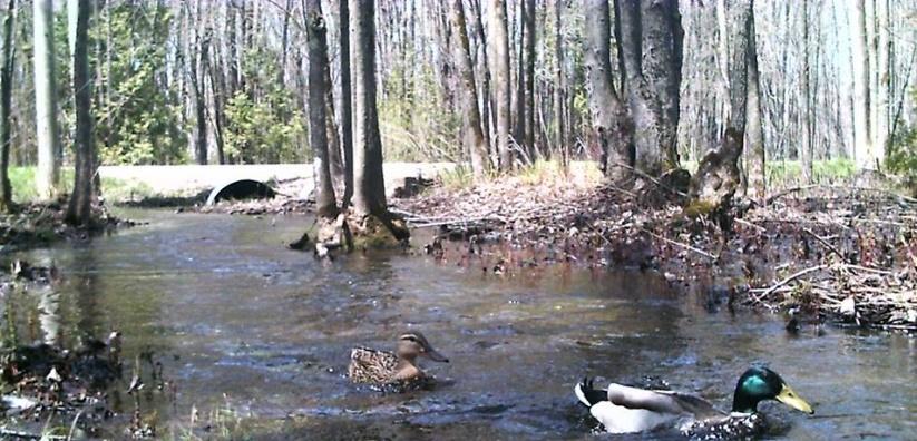
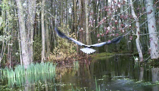
3 THE CHIPPEWAS OF GEORGINA ISLAND FIRST NATION AT A GLIMPSE 3 Located approximately100 km north of the Greater Toronto Area (GTA). Consisting of 3 separate Islands, Georgina, Snake and Fox with 2 mainland access points, Virginia Beach and Island Grove. Georgina is the largest of the Islands with a land mass of approximately 15 km2 which is 4.5 km long and 3.2 km wide, an area of 1,416 ha/4,399 acres. Infrastructure consists of an Administration building, Health Centre, Police Station, Fire Hall, Landfill site, Sewage lagoon, Water Treatment Facility, Community Centre, Church, Trails System, an Outdoor Rink, Childcare facility for infants and toddlers and a two-classroom school that accommodates the children of the First Nation until Grade 5. There are a few Member operated businesses on the First Nation which include but are not limited to Bed and Breakfasts, Cabin and Cottage Rentals, Restaurants and a Campground. The second largest Island is Snake covering an area of approximately 135ha/333acres and has 227 cottages. Fox Island is the smallest at 20ha/49acres with 52 cottages. Neither Snake Island or Fox Island have year round member residents or major Infrastructure. The forest on Georgina Island is one of the largest remaining in the GTA, covering 70% of the island. It includes 39 species of mixed wood, hardwood and conifer supporting over 400 species of flora, including several locally, regionally and provincially rare species, and approximately 143 species of birds. Rabbits, beaver, racoon, grouse, wood frogs, salamanders, foxes, wolf, wild turkey and deer also make their home in the forest and in the four adjacent wetlands.

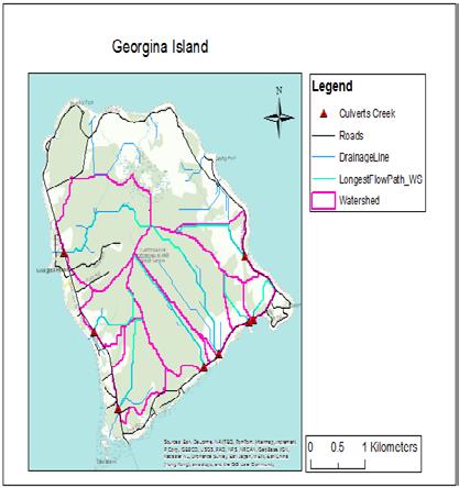
4 GEORGINA ISLAND FIRST NATION SUB WATERSHED PLANNING 4 Under the Lake Simcoe Protection Act and Plan the Lake Simcoe Region Conservation Authority was mandated to complete Sub Watershed Planning for all the Sub Watersheds within Lake Simcoe. Being that Georgina Island First Nation is made up of Islands and do not have major tributaries it was overlooked under this mandate. In August 2014 a Sub Watershed Planning Project was initiated in partnership between the Georgina Island First Nation and the Lake Simcoe Region Conservation Authority.


5 SUB WATERSHED PLAN 5 Climate Change Vegetation Breeding Birds Species at Risk Shoreline Wetland Assessment Cultural Component Community Engagement Incorporation of TEK Benthic Invertebrate and Aquatic Species Education and Outreach


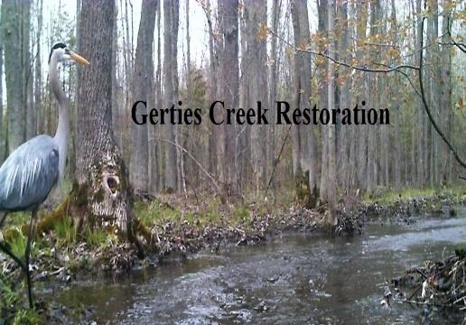
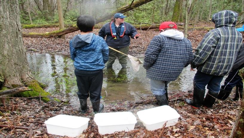
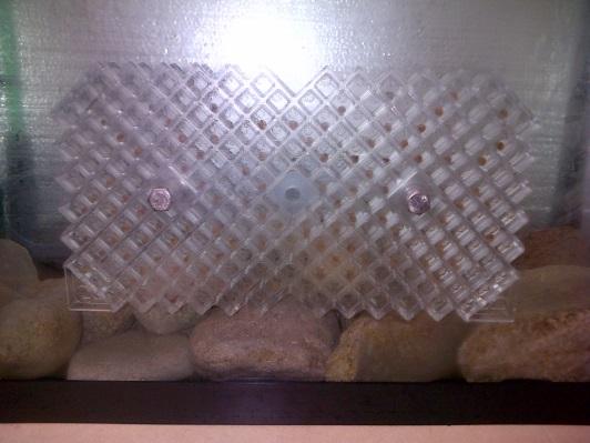
6 GERTIES CREEK RESTORATION A combination of information TEK survey Sub Watershed Plan PFC Tool Served multiple purposes Enhance and stabilize shoreline Improve fish and benthic invertebrate habitat Improve water quality Mitigate flooding effects from climate change Opportunity to incorporate the PFC tool into the project 6 EPA LSRCA MNRF Oakridge Environmental Silv Econ Ltd Community Members Community involvement Cultural Component
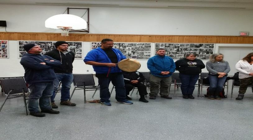
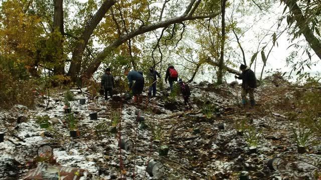
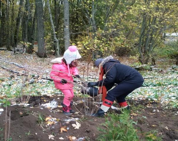
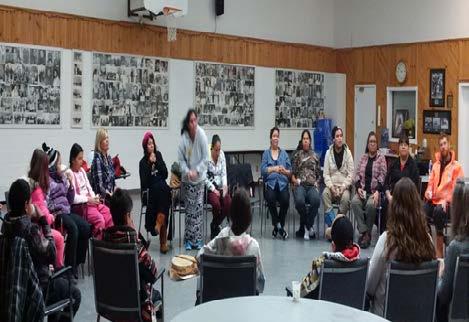
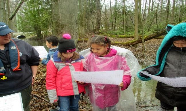
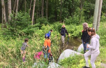
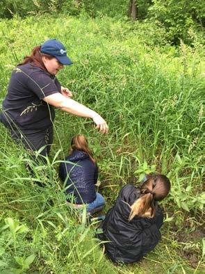
7 COMMUNITY INVOLVEMENT 7 Ceremony Traditional Teachings Community Planting


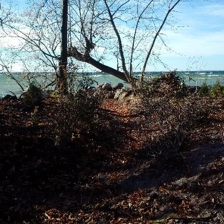
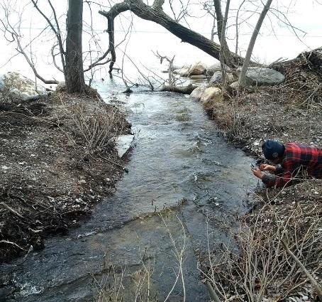
8 GERTIES BEFORE AND AFTER 8
9 MONITORING AND FUTURE PROJECTS 9


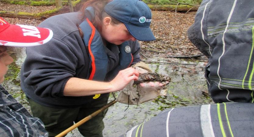
10 FISH HATCHERY AND AQUATIC PLANT PROJECT 10 LS Plan and Act TEK Partnerships Relationship building Creating Stewards Trout an Indicator fish for water quality


11 INVASIVES SPECIES 11 MANAGEMENT Identification Culturally Significant Plants Meaningful Removals Pilot Sites Education and Outreach Band Staff Summer Students Summer Camp Kids


12 Chi Miigwetch Everything is connected in someway or another so everything we do today effects tomorrow. Kerry-Ann Charles Lands and Climate Change Coordinator Cambium Aboriginal Inc 12 Love. Respect Truth Courage Wisdom Honesty Humility
The Chippewas of Georgina Island First Nation At A Glimpse
 Located in Lake Simcoe approximately100 km north of the Greater Toronto Area (GTA) in Ontario Canada. Consisting of 3 separate Islands, Georgina, Snake and Fox with 2 mainland access points.. Georgina
OPG, Nuclear 2
 B iodiversity Assessment Building a Biodiversity Management Plan November 24, 2011 OPG, Nuclear 2 Biodiversity Assessment What habitat, or your site? potential habitat, is available on What species of
Otter Lake Landowners Association (OLLA) Otter Lake News
 Otter Lake News") Otter Lake Landowners Association (OLLA) Otter Lake News Visit our website: www.otterlake.org Spring 2018 Follow us on Facebook: Otter-Lake-Landowners-Association IN THIS ISSUE: FROM THE PRESIDENT S DESK...
Otter Lake Landowners Association (OLLA) Otter Lake News Visit our website: www.otterlake.org Spring 2018 Follow us on Facebook: Otter-Lake-Landowners-Association IN THIS ISSUE: FROM THE PRESIDENT S DESK...
PROPOSED QUARRY FOOTPRINT PHASE 2 PHASE 3. PHASE 5 West. PHASE 5 East. PHASE 6 West. PHASE 6 East PHASE 7 PHASE 4 PHASE 1
 PHASE 4 \\Cd1220-f02\01609\active\2001 Active Projects\1100-1199\G1188\graphics\GIS\MXD\_Final Draft Sept 2008\MXD\Section_5\62601188_Fig5-0_ProposedQuarryFootprint_01Dec08_NJB.mxd PHASE 7 PHASE 5 West
2009 RIVER TOWN OF THE YEAR AWARD APPLICATION Supplemental Material Images
 2009 RIVER TOWN OF THE YEAR AWARD APPLICATION Supplemental Material Images Our History The earliest record of settlement along the river is in 1854; one of the earliest in Carroll County. About this time
Green Legacy. Securing our. Greenlands Strategy
 Greenlands Strategy Securing our Green Legacy Together we can create an interconnected network of Greenlands for the health and well-being of the environment and future generations Caring for the Credit
Establishing a National Urban Park in the Rouge Valley
 STAFF REPORT ACTION REQUIRED Establishing a National Urban Park in the Rouge Valley Date: March 29, 2012 To: From: Wards: Reference Number: Executive Committee Deputy City Manager, Cluster B All p:\2012\cluster
Bon Portage Island Conservation Campaign
 Bon Portage Island Conservation Campaign Protecting a Coastal Treasure Final Report to Nova Scotia Habitat Conservation Fund September 2012 Protection of Bon Portage Island Over the course of this two-year
Wilds. Headwaters. Lakes. Oxbows. Falls
 56 5 4 3 Wilds Headwaters Lakes Oxbows Falls 57 Zones It could be said the on-the-ground essence of this master plan appears within the next 6 pages of this report. As we learned in the preceding Cultural
Greening Project Status Report: Grand Canyon National Park
 Greening Project Status Report: Grand Canyon National Park Prepared for the Federal Energy Management Program U.S. Department of Energy February 2001 iii Contents Page 1. Introduction... 1 2. Context of
Niagara Natural Heritage Park
 A Future Proposal For the Niagara-on-the-Lake DND Lands....... Parks Canada Lakeshore Road Property 1 May, 2016 The Harmony Residents Group We are proposing a Natural Heritage Park be established on the
Sheboygan River Area of Concern: Moving Towards Recovery
 Sheboygan River Area of Concern: Moving Towards Recovery 2018 Wisconsin Lakes Partnership & Water Action Volunteers Symposium Amy Kretlow WI Department of Natural Resources What s Ahead What is an AOC
Michipicoten Island Regional Plan
 Michipicoten Island Regional Plan This is one of twenty Regional Plans that support implementation of the Lake Superior Biodiversity Conservation Strategy (Strategy). The Strategy, prepared and overseen
Sibley LUPA. Board Executive Committee Meeting December 7, 2017
 Sibley LUPA Board Executive Committee Meeting December 7, 2017 Project Location & Project Area 1,318-acre Robert Sibley Volcanic Regional Preserve Project Area Purpose Project Purpose & Goals Append the
Cuyahoga Valley National Park Ohio
 Cuyahoga Valley National Park Ohio Brandywine Falls The Ledges The Beaver Marsh Temperate Deciduous Forest How To Get There... Located between Cleveland & Akron, Ohio Cuyahoga Valley National Park can
Riding Mountain National Park and East Gate NHS. Management Plan Implementation Update
 Riding Mountain National Park and East Gate NHS Management Plan Implementation Update 1 Management Plan Update: 2015 Management Plans: Identify long term direction and management actions Consistent with
Clearwater Lake Provincial Park. Draft Management Plan
 Clearwater Lake Provincial Park Draft Management Plan Clearwater Lake Provincial Park Draft Management Plan Table of Contents 1. Introduction... 3 2. Park History... 4 3. Park Attributes... 4 3.1 Location/Access...4
IOWA ORNITHOLOGISTS' UNION - Birding Sites in Dallas County
 IOWA ORNITHOLOGISTS' UNION - Birding Sites in Dallas County Printed on 7/19/2018 Beaver Bottoms Wetland (restricted) (Important Bird Area) GPS Coordinates:, Ownership: Private (see directions for access)
Paul Sturm Roberto Viqueira Ríos
 Paul Sturm Roberto Viqueira Ríos In this talk Brief Background on Land Based Sources Historical Perspective Guánica watershed characteristics/ issues High priority restoration projects Other key issues
Phoenix Habitat Restoration Projects
 Phoenix Habitat Restoration Projects Spur Cross Ranch Cave Creek (Estergard) Regional Tree and Shade Summit March 9, 2010 Desert Riparian Ecosystems Healthy riparian areas like this once existed along
2.1 Physical and Biological Description Matabitchuan River Watershed
 2.1 Physical and Biological Description Watershed 2.1.1 Physical Description The system watershed has a total area of about 933 km 2 and is a tributary system to Lake Temiskaming and the Ottawa River Drainage
ONE ISLAND LAKE PROVINCIAL PARK Purpose Statement and Zoning Plan
 ONE ISLAND LAKE PROVINCIAL PARK Purpose Statement and Zoning Plan Primary Role The primary role of One Island Lake Provincial Park is to provide recreational opportunities to regional and residential area
Kwadacha Wilderness Provincial Park and Kwadacha Addition (Kwadacha Recreation Area) Purpose Statement and Zoning Plan
 Purpose Statement and Zoning Plan") Kwadacha Wilderness Provincial Park and Kwadacha Addition (Kwadacha Recreation Area) Purpose Statement and Zoning Plan Located in a remote area of the northern interior of BC, this large park straddles
Kwadacha Wilderness Provincial Park and Kwadacha Addition (Kwadacha Recreation Area) Purpose Statement and Zoning Plan Located in a remote area of the northern interior of BC, this large park straddles
Terrestrial Protected Area Nomination: Central Mangrove Wetland South-West, Grand Cayman
 Terrestrial Protected Area Nomination: Central Mangrove Wetland South-West, Grand Cayman The attached nomination, proposing that a parcel of land in the Central Mangrove Wetland be made a Protected Area
Galveston Bay Estuary Program. Carla G. Guthrie, Ph.D. Galveston Bay Council Member Texas Water Development Board
 Galveston Bay Estuary Program Carla G. Guthrie, Ph.D. Galveston Bay Council Member Texas Water Development Board The statements contained in this presentation are my current views and opinions and are
Yard Creek Provincial Park. Management Plan
 Yard Creek Provincial Park Management Plan Draft January 2010 Yard Creek Provincial Park Management Plan Approved by: telàlsemkin/siyam/chief Scott Benton Bill Williams Squamish Executive Director ation
Scat Identification A V I S U A L A I D T O I D E N T I F Y I N G S C A T J E N N I F E R B R Y S O N
 Scat Identification A V I S U A L A I D T O I D E N T I F Y I N G S C A T J E N N I F E R B R Y S O N Why do we study scat? Collecting animal scat is a non-invasive way to study animal populations and
Nags Head Woods Preserve ANNUAL REPORT
 Nags Head Woods Preserve 2017-2018 ANNUAL REPORT TOWN OF KILL DEVIL H I L L S Aaron McCall, Northeast Regional Steward September 2018 Staff Pictured from left: Jennifer Gilbreath, Conservation Coordinator,
Geoscape Toronto The Oak Ridges Moraine Activity 2 - Page 1 of 10 Information Bulletin
 About 13,000 years ago as the Laurentide Ice Sheet melted, glacial meltwater accumulated between the ice sheet and the Niagara Escarpment. This formed a lake basin into which gravel and sand were deposited.
Internship Announcement. Mount Rainier National Park. NPS Academy Internships 6 Positions. Please Respond By April 15, 2019
 NPS Academy Mount Rainier National Park Internship Announcement Mount Rainier National Park NPS Academy Internships 6 Positions Please Respond By April 15, 2019 The Northwest Youth Corps (NYC), in partnership
TRAVEL WITH CHRIS BROWN
 TRAVEL WITH CHRIS BROWN ARKABA STATION In South Australia's magnificent Flinders Ranges, one eco tourism company is doing their bit to protect native wildlife. Arkaba Station was once a sheep station but
Rouge National Park. Opportunities and Challenges
 Rouge National Park Opportunities and Challenges January 2013 Rouge Park Finch Meander Rouge Beach at Lake Ontario Toronto GLWQA Area of Concern Rouge National Park Nationally Significant First Nation
VARGAS ISLAND PROVINCIAL PARK
 VARGAS ISLAND PROVINCIAL PARK PURPOSE STATEMENT AND ZONING PLAN February 2003 VARGAS ISLAND PROVINCIAL PARK Purpose Statement and Zoning Plan Primary Role The primary role of Vargas Island Park is to protect
Conservation Area Management Statement
 Conservation Area Management Statement Miller Creek Wildlife Area Resolution #: Approval: Issue Date: Date of Last Revision: Table of Contents 1. Purpose....... 1 2. Property Description...... 1 2.1. Legal
BURGES JAMES GADSDEN PROVINCIAL PARK PURPOSE STATEMENT AND ZONING PLAN
 BURGES JAMES GADSDEN PROVINCIAL PARK PURPOSE STATEMENT AND ZONING PLAN February 2003 BURGES JAMES GADSDEN PROVINCIAL PARK Purpose Statement and Zoning Plan Primary Role The primary role of Burges James
HAROLD E. ALEXANDER SPRING RIVER WILDLIFE MANAGEMENT AREA
 HAROLD E. ALEXANDER SPRING RIVER WILDLIFE MANAGEMENT AREA HAROLD E. ALEXANDER SPRING RIVER WILDLIFE MANAGEMENT AREA Prepared by: Randy Brents Jr (Fire Management Officer) Dallas Harrell (Area Biologist)
KOOTENAY LAKE PROVINCIAL PARK (MIDGE CREEK SITE)
") KOOTENAY LAKE PROVINCIAL PARK (MIDGE CREEK SITE) PURPOSE STATEMENT AND ZONING PLAN February 2003 Approved by: KOOTENAY LAKE PROVINCIAL PARK (Midge Creek Site) Purpose Statement and Zoning Plan Primary
KOOTENAY LAKE PROVINCIAL PARK (MIDGE CREEK SITE) PURPOSE STATEMENT AND ZONING PLAN February 2003 Approved by: KOOTENAY LAKE PROVINCIAL PARK (Midge Creek Site) Purpose Statement and Zoning Plan Primary
Decision Memo Broken Wheel Ranch Equestrian Outfitter Special-Use Permit Proposed Action
 Decision Memo Broken Wheel Ranch Equestrian Outfitter Special-Use Permit USDA Forest Service Mississippi Bluffs Ranger District, Shawnee National Forest Jackson and Union Counties, Illinois Proposed Action
MAIN LAKE PROVINCIAL PARK
 MAIN LAKE PROVINCIAL PARK PURPOSE STATEMENT AND ZONING PLAN March 2003 MAIN LAKE PROVINCIAL PARK Purpose Statement and Zoning Plan Primary Role The primary role of Main Lake Park is to protect a biologically
Aquatic insect surveys at Mount Magazine State Park and Hobbs State Park Conservation Area with implementation of an educational component
 Aquatic insect surveys at Mount Magazine State Park and Hobbs State Park Conservation Area with implementation of an educational component Arkansas is home to a relatively large number of endemic invertebrates
DATE: January 19, WCA Governing Board. Johnathan Perisho, Project Manager. Mark Stanley, Executive Officer
 Item 14 DATE: January 19, 2017 TO: FROM: THROUGH: SUBJECT: WCA Governing Board Johnathan Perisho, Project Manager Mark Stanley, Executive Officer Item 14: Consideration of a resolution to accept an acquisition
$850,000 Awarded to 20 Organizations
 $850,000 Awarded to 20 Organizations The Conservation Alliance is pleased to fund the following organizations to support their efforts to protect wild lands and waterways for their habitat and recreation
Chambers of Commerce and Lake Groups advertised this NCWRPC created online survey that was : Opened: August 22, 2012; and Closed: October 4, 2012.
 Vilas County Outdoor Recreation Survey Chambers of Commerce and Lake Groups advertised this NCWRPC created online survey that was : Opened: August 22, 202; and Closed: October 4, 202. Q What Vilas County
Public Lands in Alaska. 200 million acres of federal land - Over 57 Million acres of Wilderness more than half the Wilderness in the entire nation
 Public Lands in Alaska 200 million acres of federal land - Over 57 Million acres of Wilderness more than half the Wilderness in the entire nation alaskawild.org Ground Zero for Climate Change Over the
An Introduction. The Saginaw River/Bay Area of Concern
 Saginaw River & Bay Area of Concern: Looking Forward Continued Partnerships in the Restoration of Saginaw Bay Michelle Selzer Lake Huron Coordinator & Interim AOC Coordinator Saginaw Bay Watershed Conference
NARRABEEN LAGOON SUMMIT am Wednesday, 13 April 2005 Warringah Council Chambers, 725 Pittwater Road, Dee Why.
 NARRABEEN LAGOON SUMMIT 9.15 9.30am Wednesday, 13 April 2005 Warringah Council Chambers, 725 Pittwater Road, Dee Why. NSW Minister for the Environment, the Hon. Bob Debus I am very pleased to be here to
KETTLE CREEK CONSERVATION AUTHORITY TRAIL GUIDE.
 KETTLE CREEK CONSERVATION AUTHORITY TRAIL GUIDE www.kettlecreekconservation.on.ca EXPLORE OUR TRAILS HIKE OUR TRAILS Kettle Creek Conservation Authority (KCCA) proudly supports and promotes an active lifestyle
OAK KNOLL Summer Camp
 OAK KNOLL Summer Camp Oak Knoll Wildlife Sanctuary 1417 Park Street Attleboro DISCOVER. EXPLORE. BE OUTSIDE! SUMMER 2019 ABOUT CAMP Every day is an adventure at Oak Knoll Summer Camp in Attleboro! Campers
Ohrid Lake and Prespa Lake, Sub basin s on Crn Drim river basin International Workshop, Sarajevo, Bosna and Hercegovina May 2009
 Ohrid Lake and Prespa Lake, Sub basin s on Crn Drim river basin International Workshop, Sarajevo, Bosna and Hercegovina 18-20 May 2009 Ms. Darinka Jantinska Ministry of Environment and Physical Planning
Washington Conservation Commission Minutes March 21, 2012
 Assembly time: 7:00 PM. Washington Conservation Commission Minutes March 21, 2012 Present: Jed Schwartz, Sandy Robinson, Nan Schwartz, Johanna Young 1.0 Approval of Minutes: Minutes from February meeting,
FINGER-TATUK PROVINCIAL PARK
 FINGER-TATUK PROVINCIAL PARK PURPOSE STATEMENT AND ZONING PLAN March 2003 FINGER-TATUK PROVINCIAL PARK Purpose Statement and Zoning Plan Finger-Tatuk Provincial Park is 17,151 ha in size. It includes the
ETOBICOKE CREEK NORTH TRAIL PROJECT. May 18, 2017 at Michael Power High School 105 Eringate Drive, Etobicoke ON M9C 3Z7
 ETOBICOKE CREEK NORTH TRAIL PROJECT May 18, 2017 at Michael Power High School 105 Eringate Drive, Etobicoke ON M9C 3Z7 1 Purpose of Open House The purpose of today s open house is to present the design
Nature Conservation Agency (NCA) Salacgrīva 05/07/2018
 Salacgrīva 05/07/2018") Nature Conservation Agency (NCA) Salacgrīva 05/07/2018 Nature Conservation Agency ensures implementation of unified nature protection policy in Latvia Specially protected nature areas in Latvia Specially
Nature Conservation Agency (NCA) Salacgrīva 05/07/2018 Nature Conservation Agency ensures implementation of unified nature protection policy in Latvia Specially protected nature areas in Latvia Specially
Environment and Natural Resources Trust Fund 2017 Request for Proposals (RFP)
") Project Title: Total Project Budget: $ Environment and Natural Resources Trust Fund 2017 Request for Proposals (RFP) Floating Classroom: Connecting 20,000 Youth to Minnesota Waterways Category: Proposed
Project Title: Total Project Budget: $ Environment and Natural Resources Trust Fund 2017 Request for Proposals (RFP) Floating Classroom: Connecting 20,000 Youth to Minnesota Waterways Category: Proposed
Management Direction Statement
 Management Direction Statement Rocky Fork State Park 4/18/2017 Table of Contents Rocky Fork State Park Introduction 4 Purpose of Management Direction Statements Setting and Context Park Themes Mission
SLIM CREEK PROVINCIAL PARK
 SLIM CREEK PROVINCIAL PARK PURPOSE STATEMENT AND ZONING PLAN March 2003 1 Slim Creek Provincial Park Purpose Statement and Zoning Plan Slim Creek Provincial Park is located along Highway 16, approximately
A Vision for South Skunk River and Chichaqua Bottoms Greenbelt
 A Vision for South Skunk River and Chichaqua Bottoms Greenbelt Photo: Jim Pease Chichaqua Bottoms Booklet 7 of 8 Greater Des Moines Water Trails and Greenways 1 2016 Table of Contents Booklet 1: Water
MONTAGUE HARBOUR MARINE PROVINCIAL PARK
 MONTAGUE HARBOUR MARINE PROVINCIAL PARK PURPOSE STATEMENT AND ZONING PLAN March 2003 1 MONTAGUE HARBOUR MARINE PROVINCIAL PARK Purpose Statement and Zoning Plan Primary Role The primary role of Montague
Budget Presentation City of Hamilton. January 23, 2018
 Budget Presentation City of Hamilton January 23, 2018 HCA Watershed & 2017 Highlights 2018 Budget Details HCA Land Holdings Acreage - Over 11,000 acres, ~10% of watershed In last decade have significant
Town of Oakfield Agricultural and Farmland Protection Plan
 SECTION III COMMUNITY OVERVIEW A. Regional Setting / Location The Town of Oakfield is located in the northwestern portion of Genesee County. Located west of New York's Finger Lakes, the Town is uniquely
Order of the Minister of Environment #39, August 22, 2011 Tbilisi
 Registration Code 360050000.22.023.016080 Order of the Minister of Environment #39, August 22, 2011 Tbilisi On preparatory stages and procedure of the methodology for Elaborating structure, content and
Internship Announcement. Mount Rainier National Park. NPS Academy Internships 6 Positions. Please Respond By March 1, 2019
 NPS Academy Mount Rainier National Park Internship Announcement Mount Rainier National Park NPS Academy Internships 6 Positions Please Respond By March 1, 2019 The Northwest Youth Corps (NYC), in partnership
SPECTACLE LAKE PROVINCIAL PARK PURPOSE STATEMENT AND ZONING PLAN
 SPECTACLE LAKE PROVINCIAL PARK PURPOSE STATEMENT AND ZONING PLAN August 2003 1 SPECTACLE LAKE PROVINCIAL PARK Purpose Statement and Zoning Plan Primary Role The primary role of Spectacle Lake Park is to
CARMANAH WALBRAN PROVINCIAL PARK
 CARMANAH WALBRAN PROVINCIAL PARK PURPOSE STATEMENT AND ZONING PLAN September 2003 1 CARMANAH WALBRAN PROVINCIAL PARK Purpose Statement and Zoning Plan Carmanah Walbran Provincial Park is an expansion of
Cat Island Chain Background & Access Guide
 Cat Chain Background & Access Guide Brown County Port & Resource Recovery Department 2561 S. Broadway, Green Bay, WI 54304 (920) 492-4950 www.portofgreenbay.com January 2018 1 Restoration of the Cat Chain
Stuart River Provincial Park Purpose Statement and Zoning Plan
 Stuart River Provincial Park Purpose Statement and Zoning Plan Stuart River Provincial Park protects three-quarters of the 110 kilometer long Stuart River corridor between Stuart Lake and the Nechako River.
PRESPA BIOSPHERE RESERVE MANAGEMENT MACEDONIAN PERSPECTIVE
 PRESPA BIOSPHERE RESERVE MANAGEMENT MACEDONIAN PERSPECTIVE Secretariat by Ohrid, 10.03.2016 Prespa Ohid TBB reserve Biodiversity richness trans-boundary level Total Species richness Registered over 1500
SAN ANTONIO RIVER IMPROVEMENTS PROJECT. April 27, 2009
 SAN ANTONIO RIVER IMPROVEMENTS PROJECT April 27, 2009 1 Project Limits 2 Project Partners City of San Antonio Provides project funding for project amenities (i.e.. Sidewalks, Landscaping, Lighting, etc.)
Department of Environment, Climate Change & Water NSW. Stakeholder feedback
 Department of Environment, Climate Change & Water NSW Stakeholder feedback 1 Stakeholders group Blue Gum High Forest Group Guardians of Lane Cove NP Sydney Metropolitan Wildlife Service Ku-ring-gai Historical
Case Study: 1. The Clarence River Catchment
 Case Study: 1. The Clarence River Catchment The NSW coastline is a great natural asset, making an enormous contribution to the economy. The resources of coastal catchments such as the Clarence River Catchment,
STORNETTA BROTHERS COASTAL RANCH
 STORNETTA BROTHERS COASTAL RANCH Location: Surrounding Point Arena Lighthouse and immediately south of Manchester State Park Mendocino Co., CA Acres: 1,860 Resources: Over two miles of Pacific Ocean coastline
At the Lancaster County Environmental Center. Registration Opens March 12, 2018
 2018 Summer Camps At the Lancaster County Environmental Center Registration Opens March 12, 2018 You & Me: Ages 3 & 4 with an Adult Partner Nature Exploration June 12 th & 14 th from 9:00 10:30 a.m. (EC
Potomac Gorge. Resource Booklet. A Natural Monument in the Shadow of National Monuments. Bridging the Watershed. Potomac Gorge 75
 Potomac Gorge Potomac Gorge A Natural Monument in the Shadow of National Monuments Resource Booklet Bridging the Watershed An outreach program of the Alice Ferguson Foundation in partnership with the National
ENVIRONMENTAL EDUCATIONAL PROGRAMS
 Issued December 2018 Book online now at www.epbrparkscouncil.org For more information, call us at 780-898-7275 Eagle Point-Blue Rapids Parks Systems - Where Adventure Awaits EAGLE POINT-BLUE RAPIDS PARKS
OAK RIDGES MORAINE FOUNDATION
 June 2009 OAK RIDGES MORAINE FOUNDATION The Oak Ridges Moraine Foundation was created in 2002 to help preserve, protect and restore the environmental integrity of the Oak Ridges Moraine, a prominent geological
Colorado s Instream Flow Program at 40. Celebrating 40 Years of Success and Challenges January 15, 2014 Denver, Colorado
 Colorado s Instream Flow Program at 40 Celebrating 40 Years of Success and Challenges January 15, 2014 Denver, Colorado ISF Program established in 1973 by Senate Bill 97 Recognized the need to correlate
Spatial Distribution and Characteristics of At-Risk Species in the Southeast U.S.
 Nicholas Institute for Environmental Policy Solutions Scoping Document Part 2 Exploratory Analysis of Characteristics and Trends of At-Risk Species in the Southeast U.S. Spatial Distribution and Characteristics
Resource Management Tract Management Plan. May, 2015 PHOTO NEEDED. Cover photo credit: Barry Westhead
 PHOTO NEEDED Resource Management Tract Management Plan May, 2015 A Cover photo credit: Barry Westhead 1.0 INTRODUCTION TABLE OF CONTENTS AUTHORITY RESOLUTION At Authority Meeting #6/14, held on July 25,
Pinellas County Environmental Lands
 Pinellas County Environmental Lands In addition to traditional parks and recreation facilities, Pinellas County owns and manages a system of environmental lands that provides specialized resource-based
The striking colours of the setting sun reflecting on the waters is how Crimson Lake received its name. Crimson Lake Provincial Park is a meeting
 The striking colours of the setting sun reflecting on the waters is how Crimson Lake received its name. Crimson Lake Provincial Park is a meeting place of foothills forests in the west, bog and muskeg
BLANKET CREEK PROVINCIAL PARK
 BLANKET CREEK PROVINCIAL PARK PURPOSE STATEMENT AND ZONING PLAN February 2003 BLANKET CREEK PROVINCIAL PARK Purpose Statement and Zoning Plan Primary Role The primary role of Blanket Creek Park is to maintain
LEAVE NO TRACE CENTER FOR OUTDOOR ETHICS CONSULTING SERVICES
 LEAVE NO TRACE CENTER FOR OUTDOOR ETHICS CONSULTING SERVICES LEAVE NO TRACE PURPOSE Americans love the outdoors. Today, more than 300 million people visit America s national parks and another 150 million
MARBLE RIVER PROVINCIAL PARK
 MARBLE RIVER PROVINCIAL PARK PURPOSE STATEMENT AND ZONING PLAN March 2003 MARBLE RIVER PROVINCIAL PARK Purpose Statement and Zoning Plan Primary Role The primary role of Marble River Park is to protect
Raystown Lake Handshake Awards
 Handshake Awards Allen Gwinn Park Ranger 2/24/2011 U.S. US Army Corps of of Engineers BUILDING STRONG 2004 Old Logger s Trail Wayside Exhibits 2006 NWTF Habitat Restoration 2008 Raystown Conservation Education
October 31, OAK RIDGES MORAINE FOUNDATION 120 BAYVIEW PARKWAY, NEWMARKET, ON L3Y 3W
 October 31, 2016 Land Use Planning Review Ministry of Municipal Affairs and Housing Ontario Growth Secretariat 777 Bay Street, Suite 425 (4th Floor) Toronto, ON M5G 2E5 RE: Oak Ridges Moraine Foundation
U.S. Army Corps of Engineers Fiscal Year 2013 Handshake Program Application
 U.S. Army Corps of Engineers Fiscal Year 2013 Handshake Program Application Please review instructions before completing application! Corps Lake/Project Name:Rathbun Lake/ North Shore Trail Handshake Proposal
proof Northwest District
 1 Northwest District The Northwest Florida Water Management District is the most rural of all five water management districts. From just east of Tallahassee west to the Florida/Alabama line, and from the
Section 61 Recreational Vehicle Park / Campground (Bylaw No. 2012/10)
") Part 7 General Regulations Section 61 Recreational Vehicle Park / Campground (Bylaw No. 2012/10) 61.1 A comprehensive site plan shall be provided to the satisfaction of the Development Authority that shows
Part 7 General Regulations Section 61 Recreational Vehicle Park / Campground (Bylaw No. 2012/10) 61.1 A comprehensive site plan shall be provided to the satisfaction of the Development Authority that shows
Brooker Creek Preserve Management Plan 2008 Update
 Brooker Creek Preserve Management Plan 2008 Update Plan approved by the Board of County Commissioners Pinellas County, Florida 19 August 2008 Pinellas County Department of Environmental Management Environmental
Payette National Forest Duty Station: New Meadows, Idaho Please respond by March 1, 2013
 THE OPPORTUNITY Payette National Forest Duty Station: New Meadows, Idaho Please respond by March 1, 2013 The Payette National Forest is currently seeking a candidate for a permanent full time Range Program
Seager Wheeler Lake. Representative Area. -- Concept Management Plan --
 Seager Wheeler Lake Representative Area -- Concept Management Plan -- Saskatchewan Environment and Resource Management January, 1999 Saskatchewan s Representative Areas Network Program The Government of
Sasagiu Rapids Provincial Park. Draft Management Plan
 Sasagiu Rapids Provincial Park Draft Management Plan 2 Sasagiu Rapids Provincial Park Table of Contents 1. Introduction... 3 2. Background and Park Attributes... 3 2.1 Park History.... 3 2.2 Natural Features...
Appendix C. Tenderfoot Mountain Trail System. Road and Trail Rehabilitation Plan
 Appendix C Tenderfoot Mountain Trail System Road and Trail Rehabilitation Plan All rehabilitation work would be under the direction of the District Fisheries Biologist, the Forest Hydrologist, and/or the
DOYLE SPRINGS PLANNING UNIT Kern-Tule River Watershed
 Existing Conditions & Uses Overview Consists of a mostly forested parcel with small hydropower developments and part of a private recreation cabin development, along with two small transmission line corridor
By the Numbers. Medina County Park District. Annual Report
 2016... By the Numbers Medina County Park District Annual Report From the Director Walking in nature provides many benefits to each of us who take the time to have that experience. Lowered blood pressure,
State of the Park Report Bruce Peninsula National Park of Canada
 State of the Park Report 2010 Bruce Peninsula National Park of Canada Her Majesty the Queen in right of Canada, represented by the Chief Executive Officer of Parks Canada, 2010. Cette publication est aussi
Finn Creek Park. Management Direction Statement Amendment
 Finn Creek Park Management Direction Statement Amendment November 2013 Management Direction Statement Amendment Approved by: Jeff Leahy Regional Director, Thompson Cariboo BC Parks November 12, 2013 Date
TENKILLER STATE PARK -An Overview-
 TENKILLER STATE PARK -An Overview- - 0 - TENKILLER STATE PARK Region: Northeast (Green Country) Cherokee & Sequoyah Counties CONTENTS General Information. 2 Addresses Driving Directions Phone Numbers Email
SF1363 / HF 1061: Legacy Funding; Conference Agreement
 - Conference 1 Art 1 - Outdoor Heritage Fund 2 3 Prairies 4 WMA, SNA, & Prairie Bank Easement Acq. Phase III 5 Accelerated Prairie Restoration - Phase III 6 MN Buffers for Wildlife & Water 7 Northern Tallgrass
Attendance Presentation
 TO The Community of Saanich FROM District of Saanich DATE January 30, 2017 RE Meeting Notes Haro Woods Jan 28th Community Engagement Goward House, 2495 Arbutus Road, Victoria BC Attendance In total, 18