Take care visiting natural areas
|
|
|
- Laurence Williams
- 5 years ago
- Views:
Transcription


1 Water, Take care visiting natural areas When in mountainous areas, please be prepared for sudden weather changes, cloud whiteouts and high winds on the ranges and rapidly rising water levels in rivers and streams. Extreme fire conditions can exist during summer. Permits to light fires are required all year round. No pet dogs, allowed on DOCmanaged land in Hawke s Bay. Explore Hawke s Bay NEW ZEALAND walks, Check, Clean, Dry Stop the spread of didymo and other freshwater pests. Remember to Check, Clean, Dry all items before entering, and when moving between, waterways. Protect plants and animals Remove rubbish Bury toilet waste Keep streams and lakes clean Take care with fires Camp carefully Keep to the track Respect our cultural heritage Toitu te whenua (Leave the land undisturbed) Further information and wildlife. For further information please contact or visit: Department of Conservation Hawke s Bay Visitor Centre Conservation House 59 Marine Parade Napier 4110 Phone: Fax: hawkesbayvc@doc.govt.nz For further information about recreation activities and conservation visit: Cover: Camping at Lake Tutira. Photo: Pat Sheridan. Experience them all! Published by Department of Conservation PO Box 644 Napier 4140 July >
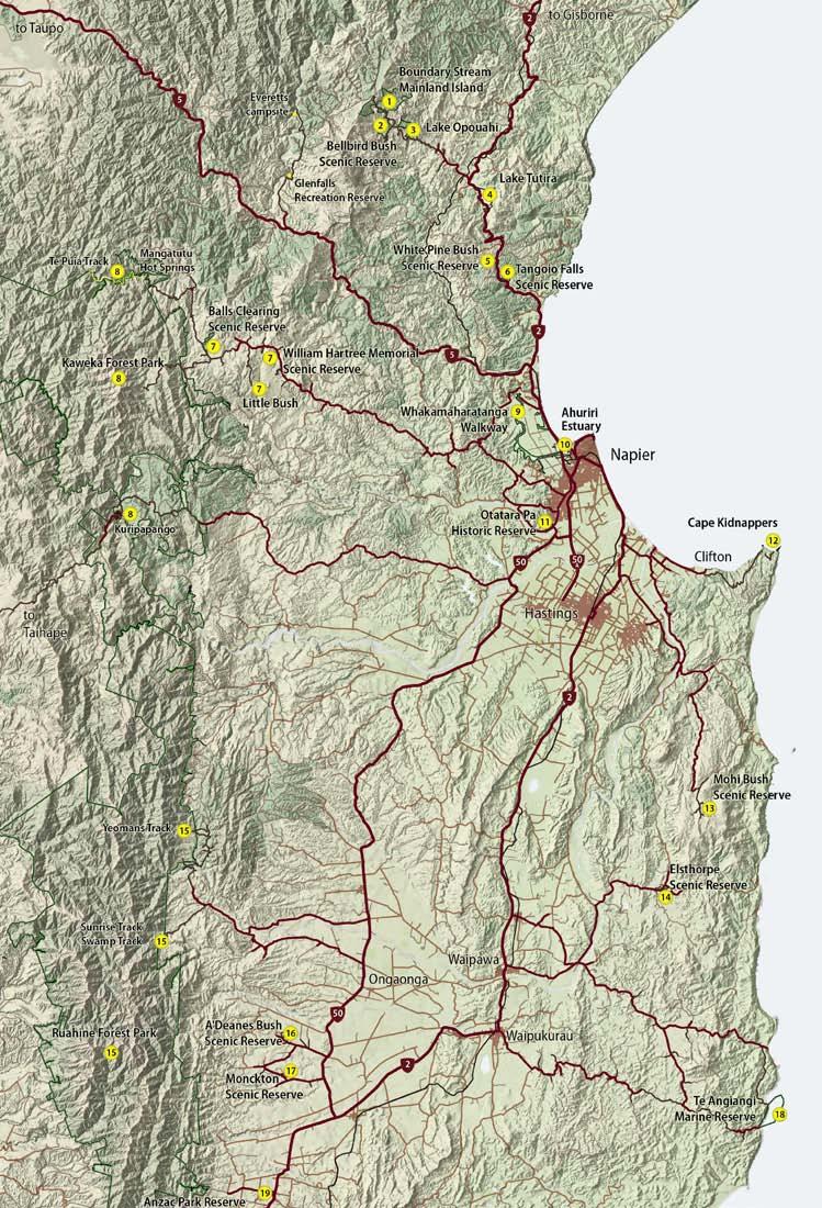
2 Introduction Welcome to Hawke s Bay s great outdoors where recreation opportunities abound for all ages and abilities. Much of Hawke s Bay is protected by forest, wildlife, marine and historic parks and reserves. The landscapes, vegetation and activities you can participate in are diverse. This brochure highlights some of the region s must see places, plants and animals you might see along the way. Places listed in the brochure are numbered and marked on the map overleaf. Enjoy! Places to stay Please note that fees are payable for overnight use of standard and serviced huts and campsites. Backcountry hut tickets or hut passes are available at any DOC office. Camping opportunities are available at Ruahine Forest Park, Kaweka Forest Park, Lake Tutira, Anzac Park Reserve, Glenfalls Recreation Reserve, and Everetts campsite in the Mohaka Conservation Area. For full information on camping opportunities, check out the North Island Conservation Campsites brochure or visit our website Robson s Lodge This lodge at Kuripapango is available for public use. Booking essential. Contact the DOC Hawke s Bay Visitor Centre or visit our website at William Hartree Memorial Lodge (Forest and Bird) This private lodge in the William Hartree Scenic Reserve near Puketitiri is available for public use. It has a fully equipped kitchen, tile fire and hot showers. Bookings essential. For more information go to Kaweka Forest Park The park provides serviced, standard and basic huts. There are also standard and basic campsites. Informal camping is permitted throughout the park. Eastern Ruahine Forest Park The eastern Ruahine Forest Park has serviced, standard and basic huts. There is also a basic campsite. Informal camping is permitted throughout the park. Tracks Hawke s Bay s 620 kilometres of track have been formed to suit a range of walking abilities. Choose a track that suits your skills, fitness and the experience you prefer. Choose the type of track that most suits the skills and abilities of your party. You must be well prepared with suitable clothing and equipment for all weather and conditions. Safety is your responsibility. Easy access short walk Suitable for people of all abilities, (assisted) wheelchairs and children s buggies Short walk Well formed, easy walking for up to an hour Walking track Well formed easy walks from a few minutes to a day Easy tramping track Generally well formed track for comfortable overnight tramping/ hiking trips Tramping track Mostly unformed but have track directional markers, poles or cairns Guide to symbols Barbecue Dogs permitted on a leash Bird watching Fishing Camping Geothermal pools Hunting Hut Kayaking Mountain biking Picnic shelter Mountain buggy SCUBA diving Picnicking Snorkeling Swimming Tap water Toilets Visitor shelter No motor boats Brochure available Meet some of the locals Kökako The kökako is one of the world s rarest birds. It is renowned for the clarity and volume of its song which carries far across the forest. Kahikatea Kahikatea or white pine grows to heights of over 60 m and is the tallest of New Zealand s forest trees. Kererü love their red fruit. Long-tailed bat This bat weighs only 10 grams, but can fly at 60 km per hour. It is an aerial insectivore, feeding on moths and beetles. Nikau palm The nikau is New Zealand s only native palm species and is the world s southernmost palm species. Its nectar is a favourite of bees, tüï and bellbirds. Weta Weta have been around long enough to see dinosaurs come and go. There are more than 70 species, all found only in NZ. Totara The mighty totara is the king of the forest, protecting other trees from storm damage. It reaches up to 30 metres, taking over 100 years to do so. Kererü The New Zealand pigeon is a very beautiful bird with irridescent green and bronze feathers. The noisy beat of its wings is a distinctive sound in our forests. Ongaonga (giant nettle) The giant nettle can cause a severe allergic reaction. It is a food source for red admiral caterpillars which roll themselves in the leaves where the plant s stinging hairs protect them from predators.


3 1. Boundary Stream Mainland Island Mainland Islands are living laboratories where we learn better techniques for restoring forest habitats. A part of this is keeping pests and predators at low levels, allowing native flora and fauna to thrive. Come visit Boundary Stream to see the results for yourself, its like taking a walk in the past. Tumanako Loop Track: 1.4 km / 1 hr The gentle land contours on this track make it an ideal walk for a wide range of visitors. Excellent interpretation panels help visitors to spot endangered species, like mistletoe, while children love to look in the weta hotels. Kamahi Loop Track: 2 hr / 4.4 km Highlights of this easy walking track include an ancient 800+ year old matai and the possibility of seeing kökako. These birds were reintroduced in 2001, watch as they run squirrel-like along branches and up tree trunks. Heay s Access Road to Shine Falls: 2.2 km / 1.5 hr return Visit the 58 m Shine Falls to see the highest falls in Hawke s Bay s, experiencing towering sandstone cliffs and beautiful native bush on the way. This is a popular place to visit, with a picnic table provided at the base of the falls. Eat lunch surrounded by trees and birds or if its a warm day, enjoy a swim. Bell Rock Loop Track: 5.3 km / 3 hr This track is named for an unusual shaped rock sculptured over the years by the wind to resemble a large bell. Enjoy extensive views along the coast and as far as Mt Ruapehu on a fine day. Try the walk in summer when a dense stand of mountain holly provides a spectacular display. 2. Bellbird Bush Scenic Reserve Bellbird Bush Scenic Reserve is aptly named for the number of bellbirds in the area. Loop Track: 800 m / 15 min Spooners Hill Loop Track: 3.6 km / 2 hr The track starts at the Pohokura Road entrance under red beech trees, before climbing up the northern slope of Spooners Hill. Enjoy extensive views of Hawke s Bay, before following the track downhill as it passes a number of karst (rock) formations and tomo (deep holes), both features of the limestone landscape. 3. Lake Opouahi Opouahi Scenic Reserve, established in 1965, is named after the deep spring-fed lake and surrounding district. Enjoy a stroll through the reserve, picnic under the shelter or spend some time kayaking on Lake Opouahi. The reserve is very special in that it s the site of the Pan Pac kiwi crèche. The reserve is partly surrounded by a 3.3 km predator-proof fence that provides a safe environment for young kiwi to grow in until they can protect themselves against predators in the wild. Lake Loop: 1.4 km / 30 min The walkway circles the lake shore, passing through regenerating native bush. Enjoy the abundant bird life and the picturesque views of Lake Opouahi. Thomas s Bush Track: 5.4 km / 4 hr A longer walk leaves the lake loop, crosses over farmland and leads into Thomas s Bush, an area added to the reserve in Enjoy the sweeping views from Mahia to Napier once you reach the ridge tops. 4. Lake Tutira Lake Tutira was made a bird sanctuary in 1929 and today is protected as a wildlife refuge. A campsite is available at the southern end of the lake, with toilets and picnic facilities. Great trout fishing is available, particularly in the lake s northern reaches, with restocking taking place each year. There are two main walks at Lake Tutira. Both are closed from August to the end of September during lambing. Non-motorised boats only are permitted on the lake. Tutira Walkway Short loop 5 km / 2 hr Long loop 7.1 km / 5 hr via Gailbraith s Track, 4.5 hr via Kahikanui Track Named after the lake and district it overlooks, the Tutira Walkway passes through Tutira Station and the adjoining Lake Tutira Recreation Reserve. Table Mountain Trig affords magnificent views of the inland Kaweka and Maungaharuru Ranges and coastal Hawke s Bay from Mahia Peninsula to Cape Kidnappers. Waikopiro Circular Track (loop): 1.1 km / 20 min The Waikopiro Track follows the shoreline of Lake Waikopiro, passing both native and introduced plants.

 can be seen.")

4 5. White Pine Bush Scenic Reserve 6. Tangoio Falls Scenic Reserve 7. Puketitiri Reserves White Pine Bush is a great place for people of all ages and abilities to visit and experience a piece of New Zealand native forest. Kahikatea (white pine) is the dominant feature in these 19 ha of bush, while an impressive stand of nikau palms provide their own unique natural beauty. A picturesque stream and small waterfall are both visible from the track sometimes small fish, eels and koura (freshwater crayfish) can be seen. The car park is also a good place to start the Tangoio Walkway which leads south from here. Please do not touch the giant stinging nettle (ongaonga), especially in summer, when its full of new growth. Despite their fierce reputation, nettles are the exclusive food of the red admiral butterfly. Tangoio Walkway is named after the forest and scenic reserve through which it passes. In pre-european times there were several Maori pä in the valley, including one near Tangoio Falls, although no evidence of it remains. Te Ana Falls: 2 km / 30 min return Tangoio Falls: 4 km / 60 min return The track follows Kareaara Stream from Tangoio Falls parking area to Te Ana Falls. Enjoy the native bush and watch for koura (freshwater crayfish) in the streams. Continue walking uphill for an additional 15 minutes to reach Tangoio Falls. Puketitiri s reserves exist largely through the efforts of some local dedicated conservationists. Of particular note, is Ball s Clearing, a stand of magnificent forest named after Jack Ball, the man who reputedly pulled his own plough. Ball s Clearing Scenic Reserve: 2.5 km / min There is no better place in Hawke s Bay to experience a lowland podocarp forest than Ball s Clearing. This outstanding example of dense virgin forest is best seen from its network of walking tracks. The reserve is also home to a significant colony of native nocturnal longtailed bats why not enjoy a twilight picnic and watch for them at dusk? Part of this walk is suitable for people in wheelchairs with assistance. Short loop track: 800 m / 30 min The short loop track has a grade and surface suitable for people using wheelchairs. This 650 m path, which takes in much that the reserve has to offer, should be completed in an anticlockwise direction. About halfway along the track, there are table and chairs, a perfect spot to sit and listen to the songs of native birds while enjoying a picnic lunch. Longer loop track: 1.6 m / 40 min Follow the longer loop track to see some large kahikatea and a great view over parts of the reserve. This section of track is not suitable for wheelchairs. Tangoio Walkway: 4.4 km / 2 hr Tangoio Walkway can be accessed from the picnic/ parking areas at either the southern end of Tangoio Falls Scenic Reserve or opposite White Pine Bush Scenic Reserve. Starting at White Pine is recommended because the going is all down hill. However, care needs to be taken when crossing SH2 from the White Pine car park to the start of the Tangoio Walkway. The walkway passes through native forest, open grassland and old and new pine plantations intermixed with redwoods and other species look out for native orchid flowers in early summer. Walking the track from north to south is recommended as the going is nearly all downhill. Please note that the track is steep in places and a stream crossing requires care after rain. Little Bush: 1 km / 45 min This is a Forest and Bird reserve, open to the public at all times. Take a walk on the circular track and enjoy the regenerating forest of abundant ferns, climbers and native orchids. William Hartree Memorial Scenic Reserve: 1.2 km / 20 min 1 hr Mrs Audrey Hartree donated this area in 1962 in memory of her late husband, William. Walk through the vigorous regenerating forest and look out for the rare mistletoe, with its small yellow-green, strongly scented flowers.

 and the climb to the tussock tops of Kaweka J (172 4m). Te Puia Track: 7.")
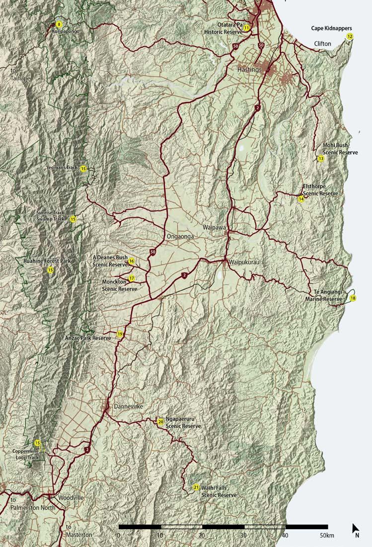
5 8. Kaweka Forest Park Alpine herbfields, shrublands, tussock valleys and beech forests with pockets of podocarp are the predominant features of this 60,000 ha conservation park. The park offers a variety of recreational opportunities including rafting, canoeing, hunting and fishing, hot springs and tramping for both experienced trampers and day walkers. Numerous picnic and camping spots are located at roadends. Highlights include the Mangatutu Hot Springs at the Gums campsite, the Mohaka River (watch for whio / blue duck) and the climb to the tussock tops of Kaweka J (172 4m). Te Puia Track: 7.4 km / 3 hr each way A popular weekend walk and a chance to enjoy a soak in the Mangatainoka hot pools. 9. Whakamaharatanga Walkway This walkway crosses farmland, most of which was under water prior to the Napier earthquake in There are two prominent old pä sites with identifiable terraces, pits and middens (shell dumps). The walkway is closed for lambing from 1 July to 30 September and may be closed at other times for farm management. Rorookuri Loop Track: 3.5 km / 1 hr Rorookuri was an island in the original Te Whanganui a Oroto lagoon and its archaeological features are of much interest. One of these, Otiere Pä, was defended by two transverse ditches and a bank across the narrow headland, both of which can still be seen today. The Rorookuri Loop Track follows the base of Rookuri Hill, past Otiere Pä and back to the carpark. Rorookuri Summit Track: 2.5 km / 40 min The other option is to walk over the top of Rorookuri Hill and back around either side. The summit offers magnificent views of Hawke s Bay. 10. Ahuriri Estuary Ahuriri Estuary was once part of a 3,800 ha lagoon, called Te Whanganui a Oroto. In 1931, a massive 7.8 earthquake rocked Hawke s Bay, raising the land over 3 metres in places. The lagoon was dramatically altered and is today about 12% of its original size. The estuary is one of the most significant in the North Island. It supports a large community of birds, fish, invertebrates and aquatic plant life. Ahuriri Estuary Loop Track: 2.7 km / 1 hr This track is an easy walk, suitable for all fitness levels, with seating provided at different viewing points. Watch small crabs as they move cautiously from their holes in the exposed mud banks, trying to avoid feeding birds. Interpretation signs are also provided, telling the area s history, its flora, fauna and the dynamics of tidal flows. The track starts at the Humber Street carpark, and follows the southern side of the estuary, past plantings done by volunteers. About 15 minutes walk from the start, the track leads onto the Embankment Bridge across the main channel of the estuary. The track continues around the northern side of the estuary and crosses Pandora Bridge back to Humber Street. 11. Otatara Pä Historic Reserve Otatara Pä is one of the largest and most ancient Maori pä sites in Hawke s Bay. It is significant for its immense size and for the large number of terraced dwelling sites and food pits. Sites where there have been fighting, deaths or burials are considered sacred by the Mäori people. Feel free to wander and look, but know that the pä contains wahi tapu (sacred places), so please respect the area. Loop Track: 2.6 km / 1 hr A loop track over the reserve starts at the carpark. It passes many archaeological features, including house sites and metre deep food pits, and leads to commanding views of the coastline and Heretaunga Plains. Look out for the narrow ridge where a 40 m ditch was dug with handcrafted tools overnight for selfpreservation. 12. Cape Kidnappers Cape Kidnappers is the largest and most accessible mainland gannet colony in the world, with around 6,500 pairs nesting at any one time. The best time to see the birds is between early November and late February. The Plateau colony, the main place for viewing the gannets, is located on private land please keep to the walking track and avoiding disturbing stock. Access to the colonies is closed from July to October to prevent disturbance during the birds early nesting phase.


6 Clifton Domain to the Gannet Reserve: 18 km / 5 hr return This walk along the beach can only be done at low tide, with the best time of departure being no sooner than 3 hours after high tide, and departing from the Cape no later than 1.5 hours after low tide. Commercial operators also provide vehicle access to the reserve. 13. Mohi Bush Scenic Reserve Mohi Bush is considered the best reserve on the Maraetotara Plateau for people to explore. The tracks are reasonably flat and the walking easy. Keep watch for the tiny rifleman, New Zealand s smallest bird. This is one of the few places the bird is found outside of the forest parks in Hawke s Bay. Mohi Bush Loop Tracks: 30 min / 1 hr The short loop cuts through the middle of the reserve, while the long loop leads to the far end of the reserve. Both tracks pass a wealth of seedlings and ferns growing underneath podocarps such as miro and matai. This reserve was one of the first in New Zealand to be treated with bait stations for possum control, and it shows take your time and enjoy the results. 15. Ruahine Forest Park Ruahine Forest Park offers a wide array of recreation opportunities including hunting, mountain biking and tramping. The ranges rise abruptly and are relatively narrow, providing high rainfall. In the south the conditions favour the growth of leatherwood (tupare), forming the largest unbroken expanse in the country. Swamp Track 2.2 km / 1 hr A low level loop track through beech, rimu and kahikatea forest. It is accessible from the Triplex carpark and from Sunrise Track. Sunrise Track: 6 km / 3 hr each way A steady climb brings you to Sunrise Hut with spectacular views of Hawke s Bay. Coppermine Creek Track: 2 km / 1 hr each way A pleasant popular walk through lowland forest to an area where copper was mined. Coppermine Loop Track: 3.3 km / 2 hr return A more strenuous option for returning to the carpark. Enjoy views of southern Hawke s Bay from the top part of the track. Yeomans Track: 4.8 km track and 3.2 km road / 4.5 hr each way A gentle low-level forest walking and mountain biking track along an old log hauling route to Yeomans Mill. A round trip can be made along Ellis Rd and Wakarara Rd. 16. A Deanes Bush Scenic Reserve A Deanes Bush is the best remaining example of the original forest of the Ruataniwha Plains. The 38.5 ha reserve, dominated by matai and kahikatea, is situated on a flat river terrace. A Deanes Bush Walk: 460 m / 20 min A large totara tree, about 34 m high, is the focal point of a 500 m track that begins at the reserve entrance. It takes at least 7 people to encircle its trunk with their arms. The track passes through the forest to the Tukipo River. If you re visiting on dusk, watch out for long-tailed bats as they emerge to feed. 17. Monckton Scenic Reserve 14. Elsthorpe Scenic Reserve This reserve is made up of two blocks of mature lowland podocarp forest with excellent examples of kahikatea, matai, miro and totara. Native birds are plentiful including kererü, tüï and fantails. Kairakau Loop Track: 600 m / 20 min The loop track at Kairakau Road provides visitors with a close view of this attractive stand of native forest. Please note that the Elsthorpe Road part of the reserve has no walking tracks through it. This 16.5 ha reserve is a mixed podocarp and beech remnant, rich in kahikatea, totara, beech, matai, tawa and kowhai. Native birds are plentiful, with spring being a good time to visit as tüï and bellbirds are attracted to the many flowering kowhai trees. Monckton Walkway: 1.6 km / 30 min The track is good quality and easily walked as it climbs and descends to the picturesque Tangarewai Stream. Use the facilities provided for picnicking and barbecuing after you ve enjoyed a walk or swim in the reserve.


7 18. Te Angiangi Marine Reserve 20. Ngapaeruru Scenic Reserve Te Angiangi Marine Reserve was established in August 1997 and covers an area of about 446 hectares, extending one nautical mile offshore between Blackhead and Aramoana beaches. Learn to snorkel in Stingray Bay, look for young paua in the rock pools or dive with large schools of butterfly perch and tarakihi found on the Boulder Bank offshore. This reserve, 15 km south-east of Dannevirke on the Tuturewa Road, is one of the best and more accessible areas of lowland mixed podocarp forest in southern Hawke s Bay. A giant tötara, said to be one of the largest in New Zealand, is a highlight. The diverse vegetation also supports many bird species their calls resonate within this basin-shaped reserve. In 1937, Ngapaeruru was a watering place for the children s horses as they travelled to and from school. Now its a popular venue for environmental education. Ngapaeruru Loop Track: 20 min This easy walking track passes through a variety of plant species, including a tall dense stand of kahikatea trees which tower above the damp river flats. Look out for the unusual native passionfruit. Their orange-red fruit is a favourite of native birds, particularly kererü. 21. Waihi Falls Scenic Reserve (Tararua DC) 19. Anzac Park Reserve (Tararua DC) This sheltered pocket of native forest, located close to Norsewood, is a pleasant place for travellers to have a short or overnight stopover. Matai and totara are prominent and there is a wealth of smaller broadleaved trees. A large grassed area adjacent to the forest is set aside for picnicking and camping with a picnic shelter, toilets, water supply and barbecue facilities provided. Overnighters are expected to pay a small charge towards facility maintenance. This rare bush remnant at Waihi Falls, 40 km south-east of Dannevirke, was Hawke s Bay s first reserve. Created in 1899, the 21 ha reserve encompasses a remnant podocarp forest including totara, matai, kahikatea and rimu. Waihi Falls is a lovely place for a picnic, with water, toilets and a picnic shelter provided for visitors. Waihi Falls: 300 m / 10 min Waihi Falls is the focal point of this short track to the base of the falls. Several vantage points along the track provide spectacular views of the falls spilling 2 5m over hard argillite rock. Arrive early with your camera as the falls photograph particularly well in the morning when the sun is shining on them.
8
9
Around and about Geraldine
 Around and about Geraldine A guide to recreational opportunities SOUTH CANTERBURY Track classifications Short walk Easy walking for up to an hour Track is well formed, with an even, welldrained surface.
Discover. Sledge Track Essence of Aotearoa
 Discover Sledge Track Essence of Aotearoa Discover Manawatu s timeless walkway adventure. Lying in the heart of the scenic Kahuterawa Valley, Sledge Track brings you face to face with the majesty of New
Discover... Sledge. Track. Essence of Aotearoa. You ll find there s much more than meets the eye!
 Sledge Discover... Track Essence of Aotearoa You ll find there s much more than meets the eye! Discover... Manawatu s timeless walkway adventure. Lying in the heart of the scenic Kahuterawa Valley, Sledge
Discover. Ashhurst Domain. Nature s Playground
 Discover Ashhurst Domain Nature s Playground Discover Step back into New Zealand, Aotearoa, of generations long gone. Discover lush natural surrounds echoing with rich birdsong in one of the Manawatu s
Location: 7km west of Invercargill on Dunns Road
 SANDY POINT DOMAIN Sandy Point Domain offers the Invercargill community important environmental and recreational resources providing opportunities for picnicking, play, walking, biking, running and as
Illawarra Escarpment State Conservation Area Walking Tracks
 Illawarra Escarpment State Conservation Area Walking Tracks NPWS Illawarra Area Office Ground Floor, Government Office Block 84 Crown Street Wollongong NSW 2500 02 4223 3000 (Mon-Fri) Royal National Park
The Aotea Track offers a range of spectacular landscapes, superb views and rich history.
 Aotea Track Located in Great Barrier Island/Aotea in the Auckland region The Aotea Track offers a range of spectacular landscapes, superb views and rich history. Travel over streams that show off a constant
TE IKA-A-MĀUI NORTH ISLAND 2017/2018
 TE IKA-A-MĀUI NORTH ISLAND 017/018 Responsible camping You could get a $00 instant fine by: Freedom camping overnight where there is a no camping sign. Freedom camping overnight where there is a self-contained
GOLDEN EARS PROVINCIAL PARK
 GOLDEN EARS PROVINCIAL PARK Trail Information as of October 10 th 2015 Do not underestimate the mountainous wilderness of Golden Ears Provincial Park. The combination of rugged terrain and rapidly changing
SPECTACLE LAKE PROVINCIAL PARK PURPOSE STATEMENT AND ZONING PLAN
 SPECTACLE LAKE PROVINCIAL PARK PURPOSE STATEMENT AND ZONING PLAN August 2003 1 SPECTACLE LAKE PROVINCIAL PARK Purpose Statement and Zoning Plan Primary Role The primary role of Spectacle Lake Park is to
Lake Manchester RECREATION GUIDE. seqwater.com.au
 Lake Manchester RECREATION GUIDE seqwater.com.au About Lake Manchester OUR VISION To manage access to recreation opportunities while protecting natural resources and water quality. Lake Manchester is located
18Day Road Tour Christchurch to Christchurch
 18Day Road Tour Christchurch to Christchurch Route: Christchurch Farlie Lake Tekapo Twizel Wanaka Queenstown - Te Anau Milford Sound - Manapouri Queenstown Wanaka Haast Fox Glacier Franz Josef Hokitika
TAUMARANUI BI-PLANE AND VINTAGE CAR EVENT which follows the Safari is charged as a separate event.
 SAFARI BEGINS AT GLENFALLS DOC CAMPSITE NAPIER: 3 rd October to 14 th October. DESTINATION TAUMARANUI BI- PLANE AND VINTAGE CAR EVENT: Monday 3 rd October to Friday morning 14 th October. SAFARI MARSHALLS:
NEW TRACK: Purerua Peninsula - Taronui Reserve Access
 NEW TRACK: Purerua Peninsula - Taronui Reserve Access NQ01 Legal access way to Taronui Reserve from Purerua Road. At the side of Purerua Road (securing may be a problem). Department of Conservation and
ROBERTS CREEK PROVINCIAL PARK MASTER PLAN. November, 1981
 Ministry of Lands, Parks and Housing Parks and Outdoor Recreation Division Park Operations Branch North Vancouver, B. C. ROBERTS CREEK PROVINCIAL PARK MASTER PLAN November, 1981 Mr. G. Trachuk Director
West Wirral (Dee Estuary)
") View of Hilbre Island from West Kirby with walkers at low tide. West Wirral (Dee Estuary) West Kirby is the start of the 12 mile long Wirral Way, the backbone of Wirral Country Park, the old Hooton to
View of Hilbre Island from West Kirby with walkers at low tide. West Wirral (Dee Estuary) West Kirby is the start of the 12 mile long Wirral Way, the backbone of Wirral Country Park, the old Hooton to
Crystal Lake Area Trails
 Lake Area Trails Welcome to the Lake area of the Big Snowy Mountains! This island mountain range in central Montana features peaks reaching to 8,600 feet and long, high ridges from which vistas of the
Park-specific management and policies Wainuiomata Recreation Area
 Park-specific management and policies Wainuiomata Recreation Area 6.8 Wainuiomata Recreation Area 6.8.1 Legal status Title held: Legislative status: Wellington Regional Council Administered under Local
Whatungarongaro he tangata, toitu te whenua. People come and go but the land endures. leave no trace new zealand
 Pocket Guide Leave No Trace Leave No Trace New Zealand promotes and inspires responsible outdoor recreation through education, research and partnerships. This pocket guide is a part of an education programme
RIDGELINE HOMESTEAD & ECO SANCTUARY WANAKA NEW ZEALAND
 RIDGELINE HOMESTEAD & ECO SANCTUARY WANAKA NEW ZEALAND We are delighted to introduce you to the Ridgeline Homestead, Cottages and Eco Sanctuary at Mahu Whenua. Located in New Zealand s South Island, just
Submission on the Tukituki Catchment Proposal: EPA reference numbers; NSP 13/ , NSP 13/ , NSP 13/ , NSP 13/02.
 Hutt Valley Tramping Club PO Box 30 883 LOWER HUTT 5045 Tukituki Catchment Proposal Environmental Protection Agency Private Bag 63 002 WELLINGTON 6140 29 July 2013 Submission on the Tukituki Catchment
FORGOTTEN WORLD HIGHWAY
 FORGOTTEN WORLD HIGHWAY New Zealand s oldest heritage trail between Taumarunui and Stratford An initiative of New Plymouth District Council FORGOTTEN WORLD HIGHWAY Don t forget Drive on the LEFT at all
Hawke s Bay Regional Parks Network. Pekapeka Regional Park Individual Park Plan
 Hawke s Bay Regional Parks Network Pekapeka Regional Park Individual Park Plan 2015-2024 Hawke s Bay Regional Council 159 Dalton Street Private Bag 6006 Napier 4110 Hawke s Bay New Zealand Telephone: 0800
Site description: 2.7 miles of intertidal habitat located about 2 miles north of Depoe Bay in Lincoln County, Oregon (Figure 16).
.") 8 Boiler Bay Site description: 27 miles of intertidal habitat located about 2 miles north of Depoe Bay in Lincoln County, Oregon (Figure 16) Designation: Boiler Bay was a research reserve before TSP publication,
8 Boiler Bay Site description: 27 miles of intertidal habitat located about 2 miles north of Depoe Bay in Lincoln County, Oregon (Figure 16) Designation: Boiler Bay was a research reserve before TSP publication,
MARBLE RIVER PROVINCIAL PARK
 MARBLE RIVER PROVINCIAL PARK PURPOSE STATEMENT AND ZONING PLAN March 2003 MARBLE RIVER PROVINCIAL PARK Purpose Statement and Zoning Plan Primary Role The primary role of Marble River Park is to protect
RIDGELINE HOMESTEAD & ECO SANCTUARY WANAKA NEW ZEALAND
 RIDGELINE HOMESTEAD & ECO SANCTUARY WANAKA NEW ZEALAND We are delighted to introduce you to the Ridgeline Homestead, Cottages and Eco Sanctuary at Mahu Whenua. Located in New Zealand s South Island, just
middle left: Riversleigh fossils lower left: Constance Range images: Hj Preuss... Thx
 Upstreampaddle Summer 2008 18 middle left: Riversleigh fossils lower left: Constance Range images: Hj Preuss... Thx top right: road west of the Isa middle right: Constance Range lower right: rocky outcrop
HIKING IN THE CANADIAN ROCKIES
 HIKING IN THE CANADIAN ROCKIES Distance Time Elevation y MORAINE LAKE TRAILS THE ROCKPILE 0.8 km (0.5 mi) 20 min 30 m (98 ft) Located adjacent to the Lodge, the short interpretive trail up the Rock Pile
C E N T R A L C A T S K I L L S
 120 C E N T R A L C A T S K I L L S Central Catskills Once out of the southern parts of the Catskills, the Long Path enters the more well traveled and civilized regions. The trail joins the Devil s Path,
Ngaio Walking Tracks map 1
 Skyline Walkway Part of this walkway runs north-south along the ridge between Mt Kaukau and Crofton Downs. It is 4 km long and takes two hours at an easy pace. On a clear day there are spectacular views
Ewen Maddock Dam RECREATION GUIDE
 Ewen Maddock Dam RECREATION GUIDE seqwater.com.au About Ewen Maddock Dam OUR VISION To manage access to recreation opportunities while protecting natural resources and water quality. Ewen Maddock Dam,
Abbotts Falls Walking Track
 Abbotts Falls Walking Track 3 hrs 7.3 km Circuit Hard track 329m This circuit takes you through both dry and moist forest, using a combination of walking trails and wider tracks. The side trip to the dammed
Pembina Valley Provincial Park. Draft Management Plan
 Pembina Valley Provincial Park Draft Management Plan 2 Pembina Valley Provincial Park Table of Contents 1. Introduction... 3 2. Park History... 3 3. Park Attributes... 3 3.1 Natural... 3 3.2 Recreational...
TREK THE ROCKIES ABOUT THE CHALLENGE TREK THE ROCKIES FOR HIGHLAND HOSPICE CANADA TREK DEMANDING
 TREK THE ROCKIES CANADA TREK DEMANDING ABOUT THE CHALLENGE The Canadian Rockies are justifiably world-famous for their magnificent scenery: the combination of impressive, jagged mountains, bright turquoise
THE THREE PEAKS OF TANZANIA
 THE THREE PEAKS OF TANZANIA Longido, Mt Meru, and Kilimanjaro in 13 days Day 1 Arrival Longido approx 10kms trekking FBA can arrange your flights to Nairobi or Kilimanjaro. If booking your own flights,
A summary of Draft Makara Peak Mountain Bike Park Master Plan
 A summary of Draft Makara Peak Mountain Bike Park Master Plan OVEMBER 216 Image: Peter Marshall 2 3 Introduction Since it was established in 1998, the Makara Peak Mountain Bike Park (Makara Peak) has grown
East West route and Leatham Molesworth route (route guide) Molesworth Recreation Reserve
 Molesworth Recreation Reserve") East West route and Leatham Molesworth route (route guide) Molesworth Recreation Reserve 0BIntroduction The East West route links the Clarence (Kahutara River in Ka Whata Tu o Rakihouia) Conservation Park
East West route and Leatham Molesworth route (route guide) Molesworth Recreation Reserve 0BIntroduction The East West route links the Clarence (Kahutara River in Ka Whata Tu o Rakihouia) Conservation Park
Silver Lake Park An Environmental Jewel for the Citizens of Prince William County
 Silver Lake Park An Environmental Jewel for the Citizens of Prince William County The Prince William Park Authority Mission Statement states: The Prince William County Park Authority will create quality
Lake Baroon RECREATION GUIDE
 Lake Baroon RECREATION GUIDE seqwater.com.au About Lake Baroon OUR VISION To manage access to recreation opportunities while protecting natural resources and water quality. Lake Baroon, located between
ANAGEMENT. LAN November, 1996
 M ANAGEMENT P LAN November, 1996 for Paul Lake Provincial Park Ministry of Environment, Lands and Parks BC Parks Department Paul Lake Provincial Park M ANAGEMENT P LAN Prepared by BC Parks Kamloops Area
The gorges of Mohican Park in Ohio create a hiker's paradise Sunday, May 22, 2011 By Bob Downing, Akron Beacon Journal
 Pittsburgh Post-Gazette The gorges of Mohican Park in Ohio create a hiker's paradise Sunday, May 22, 2011 By Bob Downing, Akron Beacon Journal Bob Downing Big Lyons Falls drops 80 feet into a shady U-shaped
This area is a popular holiday spot so watch out for 4WD vehicles and motorbikes at peak times.
 Mavora Walkway (Map 130, 129, 128) Southern Start Northern End Distance Time Track Standard Mavora Camping Area, Mavora Lakes Road Greenstone Station Road Carpark 50km 3 days Tramping track Hazards Never
NOHOANGA SITE INFORMATION SHEET TUCKERS BEACH, OTAGO. Tuckers Beach Road. Entry Point to Site. Getting there
 NOHOANGA SITE INFORMATION SHEET TUCKERS BEACH, OTAGO Getting there This site is within the Tuckers Beach Wildlife Reserve, at approximately 280 Tuckers Beach Road, 15mins drive north of Queenstown township.
Friends of Southern Eyre Peninsula Parks. Bushwalking in Lincoln National Park
 Friends of Southern Eyre Peninsula Parks Bushwalking in Lincoln National Park Select your trail Trail Time* Distance Trail Notes Stamford Hill to Surfleet Cove 1 hour one way 2.7 km one way An ideal coastal
Watchorn Provincial Park. Management Plan
 Watchorn Provincial Park Management Plan 2 Watchorn Provincial Park Table of Contents 1. Introduction... 3 2. Park History... 3 3. Park Attributes... 3 3.1 Natural... 4 3.2 Recreational... 4 3.3 Additional
KEY. Physical Activity Levels. Low = Medium = Creative = High = Accommodation Types. = Camping (Tents) = Hard Top
 = Hard Top") Program Calendar July December 2018 KEY Physical Activity Levels Low = Medium = High = Creative = Accommodation Types = Camping (Tents) = Hard Top JULY Tuesday 5 Yarra River Walk - Ideal for new participants
Program Calendar July December 2018 KEY Physical Activity Levels Low = Medium = High = Creative = Accommodation Types = Camping (Tents) = Hard Top JULY Tuesday 5 Yarra River Walk - Ideal for new participants
This Passport: Revised October 20, 2017, EAM # Discovering the Trails of Webster, NY
 This Passport: Revised October 20, 2017, EAM #161923 Discovering the Trails of Webster, NY The Town of Webster invites you to explore and experience our diverse outdoor adventures! Here s your opportunity
Arches of the. Sandflats Area. By Virginia Allen
 Arches of the Sandflats Area By Virginia Allen TABLE OF CONTENTS Introduction Dedication Road Log Arches 1. Perforated View Arch 2. Fee Booth Arch 3. Windsong Arch 4. Weird Arch 5. Resting Arch 6. Bike
KETTLE CREEK CONSERVATION AUTHORITY TRAIL GUIDE.
 KETTLE CREEK CONSERVATION AUTHORITY TRAIL GUIDE www.kettlecreekconservation.on.ca EXPLORE OUR TRAILS HIKE OUR TRAILS Kettle Creek Conservation Authority (KCCA) proudly supports and promotes an active lifestyle
RIDGELINE HOMESTEAD & ECO SANCTUARY WANAKA NEW ZEALAND
 RIDGELINE HOMESTEAD & ECO SANCTUARY WANAKA NEW ZEALAND We are delighted to introduce you to the Ridgeline Homestead, Cottages and Eco Sanctuary at Mahu Whenua. Located in New Zealand s South Island, just
TE IKA-A-MĀUI NORTH ISLAND 2017/2018
 TE IKA-A-MĀUI NORTH ISLAND 07/08 Responsible camping You could get a $00 instant fine by: Freedom camping overnight where there is a no camping sign. Freedom camping overnight where there is a self-contained
APPENDIX 19-II. Ontario Trail Network Trailheads EAST-WEST TIE TRANSMISSION PROJECT AMENDED ENVIRONMENTAL ASSESSMENT REPORT
 EAST-WEST TIE TRANSMISSION PROJECT AMENDED ENVIRONMENTAL ASSESSMENT REPORT APPENDIX 19-II Ontario Network heads Report. 1536607/2000/2219 Ontario Network heads in the n-commercial Land and Resource Use
Cooloolabin Dam RECREATION GUIDE. seqwater.com.au
 Cooloolabin Dam RECREATION GUIDE seqwater.com.au OUR VISION To manage access to recreation opportunities while protecting natural resources and water quality. About Cooloolabin Dam Cooloolabin Dam is located
PASSPORT. Discovering the Trails of Webster, NY
 PASSPORT to family wellness Discovering the Trails of Webster, NY Join the Friends of Webster Trails, Webster Health and Education Network, The Town of Webster and Wegmans to get moving more and enjoy
NARRABEEN LAGOON SUMMIT am Wednesday, 13 April 2005 Warringah Council Chambers, 725 Pittwater Road, Dee Why.
 NARRABEEN LAGOON SUMMIT 9.15 9.30am Wednesday, 13 April 2005 Warringah Council Chambers, 725 Pittwater Road, Dee Why. NSW Minister for the Environment, the Hon. Bob Debus I am very pleased to be here to
COAST TO COAST RAINFOREST TREK
 COSTA RICA TREK TOUGH ABOUT THE CHALLENGE Our adventurous coast to coast rainforest trek involves crossing from Costa Rica's Pacific Coast to the Caribbean. Enroute we take in the country s highest active
Countryside Trails Dunkeld
 R A N G E R S E RV I C E Countryside Trails Dunkeld WELCOME Welcome to this southern end of Atholl Estates. The countryside here is a wonderful blend of lochs, woodland and heather moor. There is a large
2.0 PARK VISION AND ROLES
 2.0 PARK VISION AND ROLES 2.1 Significance in the Protected Area System Marble Range and Edge Hills provincial parks protect 6.8% of the Pavillion Ranges Ecosection, which is located in the Southern Interior
proof Northwest District
 1 Northwest District The Northwest Florida Water Management District is the most rural of all five water management districts. From just east of Tallahassee west to the Florida/Alabama line, and from the
King George Area: May 5-18, 2019
 King George Area: May 5-18, 2019 Section 1: Faraway Bay airstrip to Twin Falls: May 5-12 We fly to the Faraway Bay airstrip where we leave the food for the second section, don our packs and head toward
Clearwater Lake Provincial Park. Draft Management Plan
 Clearwater Lake Provincial Park Draft Management Plan Clearwater Lake Provincial Park Draft Management Plan Table of Contents 1. Introduction... 3 2. Park History... 4 3. Park Attributes... 4 3.1 Location/Access...4
New Zealand's South Island Photographic Expedition
 New Zealand's South Island Photographic Expedition DAY 1: PRE-TOUR NIGHT: Arrive at Christchurch Airport and take the shuttle service or a taxi to your preferred Christchurch hotel. Once you arrive and
15 Nights Southern Adventurer Mid-Range South Luangwa & Southern Malawi
 15 Nights Southern Adventurer Mid-Range South Luangwa & Southern Malawi Your Trip Itinerary with Malawian Style Itinerary Outline Day Accommodation Area Board Basic Included activities Available on additional
Guided Nature Adventures
 Guided Nature Adventures wildernesslodge.co.nz Explore World Heritage Rainforests, Lakes & Wild Seacoast Few places on earth can match the wild beauty of Wilderness Lodge Lake Moeraki. Surrounded by rainforests,
MAIN LAKE PROVINCIAL PARK
 MAIN LAKE PROVINCIAL PARK PURPOSE STATEMENT AND ZONING PLAN March 2003 MAIN LAKE PROVINCIAL PARK Purpose Statement and Zoning Plan Primary Role The primary role of Main Lake Park is to protect a biologically
Lake Kurwongbah RECREATION GUIDE. seqwater.com.au
 Lake Kurwongbah RECREATION GUIDE seqwater.com.au OUR VISION To manage access to recreation opportunities while protecting natural resources and water quality. About Lake Kurwongbah Lake Kurwongbah is located
THE ISLANDS PROVINCIAL PARK
 THE ISLANDS PROVINCIAL PARK Situated at the mouth of the Roseway River on Nova Scotia s scenic South Shore, The Islands is located across the harbour from the historic town of Shelburne. The park s picturesque
BIDOUP NUI BA NATIONAL PARK Foggy Forests & Legendary Mountains
 BIDOUP NUI BA NATIONAL PARK Foggy Forests & Legendary Mountains Breathtaking natural beauty Finding new ways to protect our close relative, the gibbon Cutting edge research on climate change with 1000+
Hike at Pico Blanco Labor Day Weekend!
 Hike at Pico Blanco Labor Day Weekend! The Pico Blanco Hymn Here among the trees majestic Pleasures you will find On the trails of Pico Blanco With your friends and mine Trail the Eagle ever onward This
Lake Kurwongbah RECREATION GUIDE
 Lake Kurwongbah RECREATION GUIDE seqwater.com.au OUR VISION To manage access to recreation opportunities while protecting natural resources and water quality. About Lake Kurwongbah Lake Kurwongbah is located
Matthiessen State Park Dells Area Hike
 90 Easy Hikes Close to Home At the south end of the hike, you ll climb on top of a mound left over from a former coal-mining operation in the park. Not far from Goose Lake Prairie, the town of Morris hosts
A Publication of Friends of Sleeping Bear Dunes
 A Publication of Friends of Sleeping Bear Dunes 2014, Friends of Sleeping Bear Dunes, P.O. Box 545, Empire, MI 49630 www.friendsofsleepingbear.org info@friendsofsleepingbear.org Learn more about the Friends
beach. Make the ford and follow the trail out to the junction with Red Creek Tr in an open grassy area.
 Description: This is a moderate to slightly strenuous 22.8 mile backpack (add 2.6 miles if you do the packless out and back to the Lion s Head) that will have you exploring nearly every thing that is The
WEHC 2012 Big Six Self Drive
 WEHC 2012 Big Six Self Drive DAY 1 Cape Town Hermanus After a leisurely breakfast drive along the beautiful coastal route via Betty s Bay & Kleinmond to Hermanus. 2 nights at Francolinhof Guesthouse on
Asheville & WNC Hikes
 Asheville & WNC Hikes Amazingly, we have 3,000+ miles of free public hiking trails near Asheville, including 1,600 miles in the Pisgah and Nantahala National Forests, 850 miles in Great Smokey Mountains
Charnley Explorer June 24 - July 15, 2018 Bachsten Creek and the Charnley River. Second draft: 14 November 2017
 Charnley Explorer June 24 - July 15, 2018 Bachsten Creek and the Charnley River. Second draft: 14 November 2017 The best part of the original section one is now part of out Gibb Road Gorges trip. The dates
WALKS AND TRACKS. in Whirinaki. Pua-a-Tāne. Conservation Park go. Photos: All photos, unless otherwise credited, are copyright Neil Hutton
 All photos, unless otherwise credited, are thanks to Sven Martin. R112024 Te Pua-a-Tāne For more information on Whirinaki Conservation Park go to www.doc.govt.nz/whirinaki This publication is produced
Whitemouth Falls Provincial Park. Draft Management Plan
 Whitemouth Falls Provincial Park Draft Management Plan Whitemouth Falls Provincial Park Draft Management Plan Table of Contents 1. Introduction... 3 2. Park History... 3 3. Park Attributes... 4 3.1 Natural...
Conservation Volunteer Projects. Hauraki Area, Coromandel Peninsula
 Conservation Volunteer Projects Hauraki Area, Coromandel Peninsula Conservation Volunteer Programme Welcome to the Conservation Volunteer Programme. In this booklet are opportunities to participate in
SES Refer to the disclaimer at the beginning of this appendix.
 Appendix 1d Schedule of sites of ecological significance - inner islands AP IU ROA D O RA PIU R OAD OR 30 30 ORAPIU R AD O 30 30 OR AP IU RO AD Omaru Bay Forest : 25-12 SES 30 1:4,000 0 25 50 100 This
Borneo Holidays Portfolio
 Borneo Holidays Portfolio Borneo Wildlife and Rainforest holiday Itinerary Borneo Holidays Portfolio Borneo Wildlife and Rainforest Holiday 8 Days 7 Nights HIGHLIGHTS Kota Kinabalu Sandakan Sepilok Sukau
Camp Jack Wright PERMANENT ORIENTEERING COURSE (2004)
") Camp Jack Wright PERMANENT ORIENTEERING COURSE (2004) WHAT IS ORIENTEERING? The skill which enables a person to navigate with a map. In the competitive sport, the winner is the person who finishes in the
Camp Jack Wright PERMANENT ORIENTEERING COURSE (2004) WHAT IS ORIENTEERING? The skill which enables a person to navigate with a map. In the competitive sport, the winner is the person who finishes in the
Lewis and Clark Recreation Area
 Lewis and Clark Recreation Area Bicycle/Pedestrian Trail Also part of the Pierson Ranch Recreation Area trail Type of trail: Walking, biking and rollerblading Trail surface: Asphalt Rated: Mostly flat.
Around and about Mid-Canterbury
 Around and about Mid-Canterbury A guide to recreational opportunities mid canterbury www.doc.govt.nz Published by Department of Conservation Canterbury Conservancy Private Bag 4715 Christchurch, New Zealand
Te Manahuna Consulting
 Assessment of the natural values at the proposed centre pivot irrigation site and surrounds on Ben Ohau Station, Mackenzie Basin, New Zealand August 2016 Abstract The natural values of the area proposed
IOWA ORNITHOLOGISTS' UNION - Birding Sites in Dallas County
 IOWA ORNITHOLOGISTS' UNION - Birding Sites in Dallas County Printed on 7/19/2018 Beaver Bottoms Wetland (restricted) (Important Bird Area) GPS Coordinates:, Ownership: Private (see directions for access)
Department of Conservation National Survey Report 1: Quintessentially Kiwi
 Department of Conservation National Survey Report 1: Quintessentially Kiwi Survey conducted: June 2011 Reporting produced: September 2011 Contents 1.0 Methodology... 3 2.0 Findings... 5 2.1 Places... 5
Stephens State Park Trails
 TRAILS OF ALLAMUCHY MOUNTAIN & STEPHENS STATE PARKS Allamuchy Mountain and Stephens State Parks contain 28 marked trails providing access to diverse landscapes for walking, hiking, biking, bird-watching,
This Passport: Revised October 20, 2017, EAM # Discovering the Trails of Penfield, NY
 This Passport: Revised October 20, 2017, EAM #161922 Discovering the Trails of Penfield, NY The Town of Penfield is fortunate to have a wide variety of natural resources which make for many unique and
Note: Tour duration includes travelling time to and from the attraction. 4 hours Daily 8.00am 8.30am
 WILDLIFE ENCOUNTER MORNING @ THE ZOO (WITH JUNGLE BREAKFAST OPTION) Leave the city behind as we head north to Mandai and visit one of the world s top and most beautiful zoos. The Singapore Zoo* is spread
Silver-washed Fritillaries in the Straits Inclosure in July
 ALICE HOLT FOREST Hampshire from www.discoverbutterflies.com the website for the book Discover Butterflies in Britain D E Newland Silver-washed Fritillaries in the Straits Inclosure in July Alice Holt
Staples Lookout to Mt Wondabyne loop
 Staples Lookout to Mt Wondabyne loop 4 hrs 3 mins 1.8 km Circuit Hard track 337m This walk starts and finishes at Staples Lookout, on Woy Woy Rd. The walk follows sections of the Great North Walk around
Park-specific management and policies. Akatarawa Forest
 Park-specific management and policies Akatarawa 6 Park-specific management and policies 6.1 Akatarawa 6.1.1 Legal status Title held: Legislative status: Wellington Regional Council Administered under Local
TRAVEL WITH CHRIS BROWN
 TRAVEL WITH CHRIS BROWN ARKABA STATION In South Australia's magnificent Flinders Ranges, one eco tourism company is doing their bit to protect native wildlife. Arkaba Station was once a sheep station but
CRAZY HORSE TRAIL GUIDE
 CRAZY HORSE TRAIL GUIDE Abridged Version: July 2016 This is a short form of our interpretive trail guide for the Crazy Horse Trail. The full version of the guide has a more detailed description of the
Access: The rocky shoreline is only accessible via private property.
 10. Whale Cove Site description: Whale Cove is a small cove fringed by private homes and condominiums with diverse and relatively undisturbed rocky intertidal and subtidal habitat located approximately
Appendix A BC Provincial Parks System Goals
 Appendix A BC Provincial Parks System Goals The British Columbia Provincial Parks System has two mandates: To conserve significant and representative natural and cultural resources To provide a wide variety
Best Hikes on Orcas Island
 Published on San Juan Islands Washington Visitors Bureau Orcas Island Lopez Island Friday Harbor San Juan Island (https://www.visitsanjuans.com) Best Hikes on Orcas Island The Emerald Isle offers big trees,
Project Island Song Wildlife Sanctuary, Bay of Islands
 Project Island Song Wildlife Sanctuary, Bay of Islands All of the islands of the eastern Bay of Islands (Ipipiri) are now rat-, mouse- and stoat-free. Many hours and money has been spent to get them to
Driving Time: 3 hours (allow extra time for stops)
") Scenic Byways loop This journey takes visitors through the eastern edge of Mt. Rainier National Park and along two of Washington s most beloved scenic byways, the Chinook Byway and the White Pass Scenic
Scenic Byways loop This journey takes visitors through the eastern edge of Mt. Rainier National Park and along two of Washington s most beloved scenic byways, the Chinook Byway and the White Pass Scenic