Canadian Cataloguing in Publication Data BC Parks. South Coast Regional Planning Services. Stawamus Chief Provincial Park management plan
|
|
|
- Penelope Lawson
- 5 years ago
- Views:
Transcription
1
2
3 Canadian Cataloguing in Publication Data BC Parks. South Coast Regional Planning Services. Stawamus Chief Provincial Park management plan Cover Title: Management plan for Stawamus Chief Provincial Park. ISBN Parks - British Columbia - Squamish Region - Planning. 2 Parks - British Columbia - Squamish Region - Management. 3. Stawamus Chief Provincial Park (B.C.) - Management. I. BC Parks. Garibaldi/Sunshine District. II. Title. III. Title: Management plan for Stawamus Chief Provincial Park. FC3815.S72B '3' C F1089.S72B
4
5 STAWAMUS CHIEF PROVINCIAL PARK MANAGEMENT PLAN TABLE OF CONTENTS Message from the Citizens Advisory Committee...i Vision Statement for Stawamus Chief Provincial Park...i Acknowledgements...ii Plan Highlights...iii INTRODUCTION...1 What is a Management Plan?...1 Purpose of the Plan...2 Planning Issues...2 Background Summary...4 Page ROLE OF THE PARK...7 Regional and Provincial Context...7 Conservation Role...g Recreation Role...9 Vision Statement...10 PARK ZONING...11 Introduction...11 Stawamus Chief Provincial Park...11 Special Feature Zone...11 Intensive Recreation Zone...11 Natural Environment Zone...11 NATURAL AND CULTURAL RESOURCE MANAGEMENT...13 Introduction...13 Land and Boundary...13 Water...15 Vegetation...15 Wildlife...17 Cultural and Historical Values...19 Visual Resources...19 Relationship with First Nations...21 VIS ITOR S ERVIC ES...22 Introduction...22 General...22
6 TABLE OF CONTENTS Continued Page Outdoor Recreation Opportunities...22 Hiking...22 Climbing...24 Camping...25 Viewing and Picnicking...26 Safety and Risk...27 Access Strategy...28 Interpretation and Education...29 Information Strategy...30 Marketing and Promotion...30 Management Services...30 Volunteers, Stewardship and Partnerships...30 Commercial Activities...31 PLAN IMPLEMENT ATION...32 Introduction...32 Highest Priority Actions...32 Task or Project-Oriented Actions...34 Ongoing and Monitoring Actions...35 LIST OF FIGURES 1 Protected Areas Study Boundary Regional Map Zoning... 4 Status Map... 5 Trails and Development Map...23 APPENDICES A BC Parks Systems Goals...37 B BC Parks Zoning Policy...38 C Plant List...40 D Stawamus Chief Schedule...43 E Stawamus Chief Study Area Final Report (June, 1994)...46 PHOTOS View from the Chief between the Second and Third Peaks...4 Remnants of Old-growth Forest...7 View of Second Peak from Third Peak...10 Swamp East of the Chief...17 View from the Chief across the Squamish Valley...20 Climbers on the Chief...25 Viewpoint from Second Summit...26 Trail to the Summits of the Chief...29
7 Stawamus Chief Provincial Park Management Plan
8 MESSAGE FROM THE CITIZENS ADVISORY COMMITTEE The Advisory Committee for the Stawamus Chief Management Plan is in agreement that the experience of the Chief goes into a realm beyond that of stunning views, fabulous climbing and tourism potential. The magic of the quiet trail, the wonder of the lonely bird call, the rootedness of the rock mass, the challenge of the abrupt elevation gain and the awe inspiring views provide an easily accessible opportunity to get away and get above every day reality that brings refreshment to the spirit as well as the body. There is a sense of pilgrimage about returning to the Chief. Recognition of the spiritual value of the Stawamus Chief is shared by aboriginal and nonaboriginal people, local residents and area visitors. The elusive spiritual value to the Stawamus Chief is very precious and managing the park to ensure the integrity and longevity of the spiritual place has been a priority of the Advisory Committee. Citizens Advisory Committee Stawamus Chief Management Plan July, 1996 VISION STATEMENT FOR STAWAMUS CHIEF PROVINCIAL PARK The Management Plan for the Stawamus Chief Provincial Park must ensure a high level of protection of the granite monoliths, their surrounding features and natural ecosystems. It will also provide guidance to enhance the infrastructure for the traditional activities of rock climbing, hiking, viewing and nature appreciation, while respecting the spiritual and cultural values important to the Squamish First Nation and park visitors. i
9 Acknowledgements This plan was prepared by the Regional Planning staff of the South Coast Region, the Garibaldi/Sunshine Coast District, Victoria headquarters and a volunteer Advisory Committee. Under the direction of Drew Carmichael, District Manager for Garibaldi/Sunshine Coast District; Jim Morris, Regional Planner for the South Coast Region coordinated the project and prepared the plan. Two volunteers, Marijn van Oostrum and Polle Marschalk, assisted with the writing of the plan. Roger Norrish, Management Plan Coordinator provided assistance and expertise to this plan. BC Parks would like to give special recognition to the members of the public who volunteered their time to be on the Advisory Committee and help prepare this plan. The following people have been active participants on the Advisory Committee: Meg Fellowes (co-chair person) Rachel Sheppard (co-chair person) Jim Firstbrook Anders Ourom Kevin McLane Genevieve Leger Paul Kindree Frank Limshue Beverley Goodwin Randall Lewis Jim Sandford Scott Flavelle Darcy West Chuck Dick Lorne Johnston Ron Goldstone John C. Howe Squamish Estuary Conservation Society Squamish Rockclimbing Association Squamish Rockclimbing Association Climbers Access Society of British Columbia Climbers Access Society of British Columbia Climbers Access Society of British Columbia Squamish Search and Rescue District of Squamish District of Squamish Parks and Recreation Squamish First Nation Squamish Rock Guides Association Canadian Mountain Guides Squamish Chamber of Commerce Federation of Mountain Clubs of British Columbia Federation of Mountain Clubs of British Columbia Squamish Rockclimbing Association Forester and Squamish Search and Rescue ii
10 PLAN HIGHLIGHTS Continue to pursue land acquisition in the PAS study boundary as recommended in the Stawamus Chief Study Area Final Report (June, 1994). Establish an ongoing Advisory Committee to provide input for Annual Management Plans, research projects and other park-related issues as required. Vehicle access to the park will not be encouraged through the Stawamus watershed. Protect sensitive or unique vegetation communities from future park development through zoning. The park will be closed to hunting and all open fires. Develop a strategy with the Squamish First Nation that will protect and allow for the continued practice of traditional activities for present and future generations of First Nations people in relation to the lands within the park. Upgrade all existing designated trails to park standards and improve signage on the existing trail network. Develop a rock climbing strategy in conjunction with experienced rock climbers that addresses a number of issues (eg. safety, code of conduct, route locations, facilities and signing). Develop a campground with sanitary facilities that emphasizes low impact, walk-in access, rustic camping and limited vehicle high density campsites. Camping will be restricted to only designated campsites unless authorized for special purposes by the District Manager. Develop a risk assessment, risk strategy and prepare a safety and rescue plan in conjunction with Squamish Search and Rescue and other organizations. Install an emergency telephone. Design and develop an interpretive strategy to enhance public awareness concerning the environmental, natural and cultural values in the park. Rock climbing guiding, hiking and nature interpretation will continue to be commercial recreation services offered on the Stawamus Chief. iii
11 INTRODUCTION What is a Management Plan? A Management Plan is an administrative manual which guides a park s management for a five to ten year term. It sets out objectives and actions for conservation, development, interpretation and operation of the park. A Management Plan relies on current information on park resources, recreation uses and activities occurring on surrounding lands. This information is available from park managers, discussions with other government agencies, previously prepared reports, public interest groups, study teams and from the general public. The process for preparing a plan involves a rigorous analysis of the overall goals of the park, patterns of use, management objectives and possible sources of conflict among park policies. In choosing the most appropriate options, the intent is to reach a balance between recreation and conservation. Management Plans establish long-term management direction for a park as well as dealing with immediate issues. This means that the plan will generally contain numerous statements describing management actions that need various degrees of attention. Since BC Parks cannot carry out every task at the same time, the plan must also set priorities for management actions. Approval of the Management Plan is not an indication that funding to implement management actions is available. Standard funding procedures will apply during implementation of the plan. BC Parks prepares Management Plans with a high degree of public involvement. The general public and public interest groups have opportunities to provide comments through a variety of means including public meetings, questionnaires and local study teams. This Management Plan for Stawamus Chief Provincial Park has been prepared by the BC Parks staff with assistance of a volunteer advisory committee. The plan is based on committee, staff and public input. Public input has been received through public open house meetings. Each section of the Management Plan provides a brief summary of relevant background information. More detailed information can be obtained from the Stawamus Chief Background Report. The Management Plan is organized into six main sections: 1) Purpose or context of the plan, highlighting planning issues and providing a summary of background information on the park. 2) Role of the park and its vision statement, describing the importance of the park and critical goals and principles that establish a long term foundation for managing the park. 3) Park zoning, defining how different areas of the park will be managed. 1
12 4) Objectives and associated actions for managing the park s natural and cultural purposes. 5) Objectives and actions for providing outdoor recreation opportunities and for providing information in and about the park. 6) Priorities for implementing the management. Purpose of the Plan The purpose of the Management Plan is to guide all park resource use and visitor service decisions that will be made in the next five to ten years, that will allow Stawamus Chief Provincial Park to preserve its special natural and cultural features, while attaining its full potential within the overall park system in British Columbia. The plan also describes the expectations of the public and the Squamish First Nation for the park, based on the public involvement process, through the advisory committee and open house meetings and consultation with the Squamish First Nation. Planning Issues Role of the Park Since the Stawamus Chief is a rock climbing area of international importance, the main role of the park will focus on recreation. The Stawamus Chief s hiking trails are among the most used trails regionally. The Squamish Chief has long been recognized as a special feature in the Protected Area Strategy 1 and protection of this special feature is an other important role. The park also gives the opportunity to inform the public about both the consequences of human impact and gaining appreciation for the natural and cultural values of the park. Adjacent to the Stawamus Chief and included in the park is Shannon Falls, which is also recognized as a special feature and is the third highest waterfall in British Columbia. Park Boundary The present boundaries will be reviewed during the plan process, including reviewing adjacent mineral leases. 1. The second goal of the Protected Areas Strategy is To protect the special natural, cultural heritage and recreational features of the Province, including outstanding or unique geological features 2
13 Shannon Falls Provincial Park is located immediately east of Stawamus Chief. It already has a Management Plan. Both the boundaries between the parks and the Shannon Falls Management Plan will be taken into consideration. Level of Development The Stawamus Chief has been extensively used as a rock climbing area, prior to park designation. It is estimated that about 50,000 hikers and 25,000 climbers enjoy the Stawamus Chief annually, and it is expected that this number will increase approximately ten percent yearly. The level of development will depend on the recreational use/needs, but protection of the special features and conservation of the natural and cultural resources will also play a major role. The final level of development will be determined in this Management Plan. Management of Park Resources Stawamus Chief Provincial Park conserves vegetation, wildlife, water, special features and cultural/historical values. These resources can be affected by development occurring in and around the park and by how the park is used for recreation. In response to these factors, conserving the resources will increasingly depend on active, or hands-on management strategies and obtaining more information about the resources. The Management Plan sets direction for managing these resources and prioritizing information needs. BC Parks Relationship with First Nations Stawamus Chief Provincial Park is of great interest for the Squamish Band. In managing the resources of the park, the plan sets direction for communicating and cooperating with First Nations people. Park Promotion How the park is promoted can have considerable affects on long-term visitor patterns. The plan provides direction on how the park will be promoted with consideration given to affects of increasing visitor numbers, mostly climbers, on the conservation goals for the park. Interagency Cooperation In many ways, Stawamus Chief Provincial Park is connected to the surrounding lands. Ecological processes, water, air, vegetation, wildlife and people move across the park boundary, and consequently the park cannot be treated in isolation from surrounding lands. This plan sets direction for cooperating with other government agencies, industries and non-government organizations to develop management strategies for conservation and recreation. 3
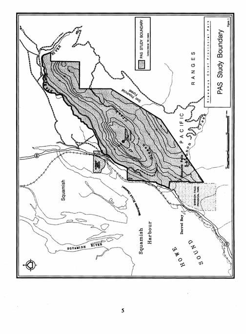
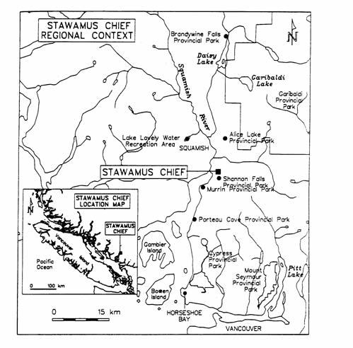
14 Background Summary The Stawamus Chief was named after the Indian village of STA-a-mus, at the mouth of the Squamish River. The Stawamus Chief consists of a series of peaks located on a pronounced ridge between the Stawamus River and Olesen Creek. Located immediately to the south of the town of Squamish, the lands that presently will be designated as Class A Provincial Park contain approximately 524 hectares, while the proposed Protected Areas Strategy (PAS) study boundary contains 700 hectares. This area lies partially within the District Municipality of Squamish. The park is situated on the Sea to Sky Highway 99; an hour s drive from Vancouver (Figure 1). Along this highway motorists will see impressive natural features and places like Whistler, an international ski destination that attracts more tourists every year along this route. View From the Chief Between The Second and Third Peaks 4
15 5
16 The area is situated in the Southern Pacific Range CWHdm (Coastal Western Hemlock dry maritime) biogeoclimatic zone. The climate in this area is typical of the south coast with mild, wet winters and warm, sunny summers. Mean average daily temperatures range from 23 0 Celsius in July to 4 0 Celsius in January, with a May to September summer season mean of 15 0 Celsius. Precipitation averages approximately 130 to 150 centimetres per year. BC Parks Plan 90 Special Features for BC Parks report identified the Stawamus Chief as an outstanding, provincially significant special feature of igneous rock. A second special feature in the park is Shannon Falls, third highest waterfall in British Columbia. The Stawamus Chief has been known internationally for its rock climbing opportunities for several decades. Known as one of the largest freestanding monoliths, the 700 metre high Stawamus Chief provides excellent rock climbing routes for both beginner and experienced climbers. The area is also popular for hiking and it offers some breathtaking views of Howe Sound and the town of Squamish. Most of the trails lead to the top of the Stawamus Chief and one trail connects to neighbouring Shannon Falls Provincial Park. The Federation of Mountain Clubs of British Columbia (FMCBC), stated in its report, The Granite Monoliths of Squamish, that this area provides outstanding recreational opportunities and acts as a tourism asset to the town of Squamish. Nearly half the area has been logged in the past and the forestry values today are poor or moderate. There are pockets of old-growth forest left and the Squamish Forest District has identified 14 rare or endangered plant species, some of which may also exist in the park. Also of interest is a verified peregrine falcon nesting site located within the park, which is of importance as the peregrine falcon is on the Red List. 6
17 ROLE OF THE PARK Regional and Provincial Context The Stawamus Chief and the other provincial parks along Highway 99 attract local, regional, national and international visitors (Figure 2). It is estimated that there may now be as many as 50,000 hikers and 25,000 climbers annually who enjoy the Stawamus Chief, and that a 10% increase in the number of visits yearly may be expected. The adjacent Shannon Falls Provincial Park attracted 461,293 visitors in The park also has long been acknowledged as a rock climbing area of international importance. The enhancement of these tourism assets can be of substantial benefit to local communities, both in terms of economic value and community pride. The Stawamus Chief area has significant historical and cultural values for people of the Squamish First Nation. Remnants of Old-growth Forest 7
18 8
19 Conservation Role The Protected Areas Strategy (PAS) has two conservation goals: landscape presentation and special feature conservation. The Stawamus Chief and Shannon Falls are both recognized as special features through the PAS process. The overall management objective is to conserve the special feature, the granite monolith, and the ecological and cultural values of the area, in order to provide education and recreation opportunities. One of the conservation goals of the government is to protect 12% of each biogeoclimatic zone. The biogeoclimatic zone in which the park is situated, the Southern Pacific Range CWHdm (Coastal Western Hemlock dry maritime), is only protected for 2%. Conservation of the area of the Stawamus Chief would contribute to the protection of this biogeoclimatic zone. The northern slopes contain small pockets of old-growth forests. Recreation Role Stawamus Chief Provincial Park provides rock climbing opportunities for both experienced and novice climbers. The Chief, The Squaw, and The Apron, together form the main climbing area. There are numerous routes to these different summits. These rock climbing opportunities are unparalleled in North America. The numerous hiking trails to the summits and Chieftain viewpoint provide spectacular focal views of the Chief and panoramic views over Howe Sound and the town of Squamish, linking the area to adjacent Shannon Falls. The trails in the park are all extremely rugged and vary in length. 9
20 Vision Statement The Management Plan for Stawamus Chief Provincial Park must ensure a high level of protection of the granite monoliths, their surrounding features and natural ecosystems. It will also provide guidance to enhance the infrastructure for the traditional activities of rock climbing, hiking, viewing and nature appreciation, while respecting the spiritual and cultural values important to the Squamish First Nation and park visitors. View of Second Peak From Third Peak 10
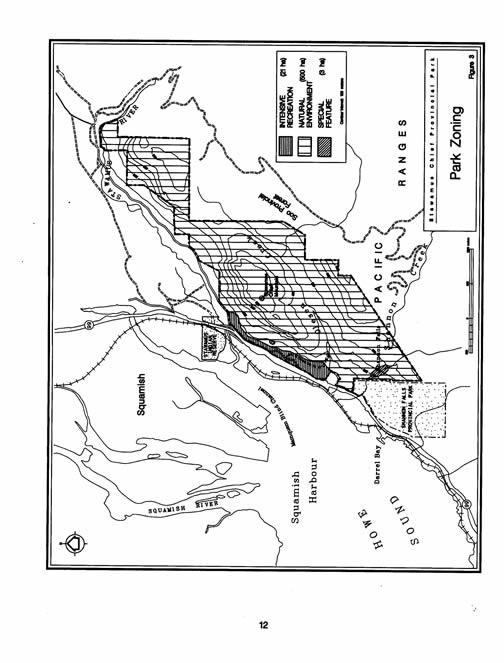
21 PARK ZONING Introduction Zoning 2 is a procedure used to assist the planning and the management of Park Act designation by dividing each park into logical land and water units based upon uniform and consistent management objectives. Park zoning is used to assist in planning the development and management of provincial parks. The zones reflect the intended land use, the appropriate level of management and development, and the type and level of human activity to be accommodated. Appendix B provides a detailed description of BC Parks zoning. Stawamus Chief Provincial Park The Stawamus Chief Park is divided into three zones (Figure 3): Special Feature Zone The Special Feature Zone identifies areas where the management objective is to protect and present significant natural or cultural features or processes because of their special character, fragility or heritage values. The Stawamus Chief Provincial Park contains a number of special features including Shannon Falls, the third highest waterfall in British Columbia and the Cacodemon Caves. This zone contains approximately three hectares. Intensive Recreation Zone The objective of the Intensive Recreation Zone is to provide for a variety of readily accessible, facility-oriented outdoor recreation opportunities. This zone comprising some 25 hectares includes the highly visited and developed parts of the park including the campground, park road and parking lots. While development is aimed at managing a high number of visitors, the setting will be maintained in as natural a state as possible. Natural Environment Zone In this zone, the natural environment will be protected. Facilities will be provided where they are necessary to maintain the natural environment, where there are interpretation opportunities, and where they will enhance recreation opportunities. The intent is to ensure that park facilities do not dominate the natural setting, and trail development will make use of the natural terrain and scenic value. This zone covers the remaining area of the park and contains approximately 500 hectares. 2 Zoning = dividing a certain area into sub-areas based on identification of natural, cultural and recreational values, and analysis of existing and projected patterns of access and recreation use. The zone boundaries do not necessarily correspond to natural ecological systems. 11
22 12
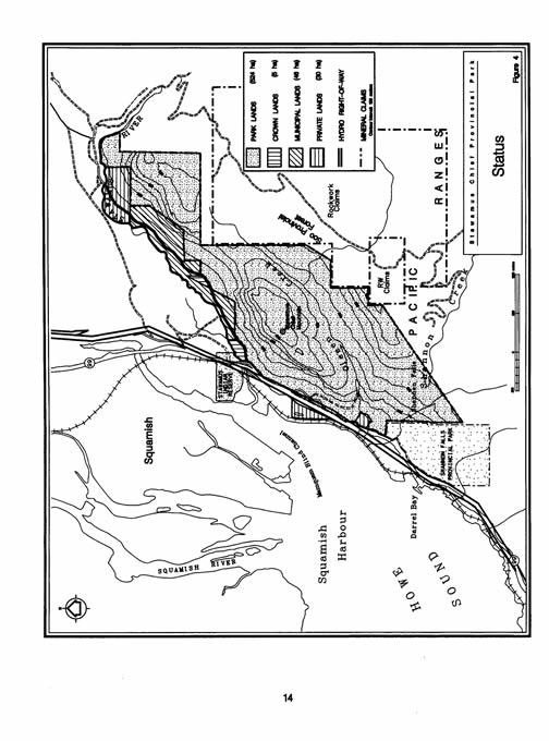
23 NATURAL AND CULTURAL RESOURCE MANAGEMENT Introduction Park management will be directed towards conserving the natural features, ecosystems and cultural features, while providing opportunities for compatible outdoor recreation activities. Thus, the objectives of natural and cultural values protection in Stawamus Chief Provincial Park will stress managing human impacts to prevent degradation of the natural ecological processes and cultural features. This section outlines management objectives and actions which provide general direction regarding park management and identifies priorities for specific management plans. These objectives and actions comply with the Park Act, Park Regulations and relevant ministry policies. Land and Boundary The boundary of a park is an administrative tool to define lands on which BC Parks has legislative authority to manage natural and cultural resources and provide recreation opportunities. The recommendations of the Regional Protected Areas Team (RPAT) led to a process of land acquisition and establishment of the park (Figure 4). Objectives: To minimize the potential impact of mining on the park in the future (eastward of the proposed park boundary are several potential quarry sites). To manage the park s land to protect its natural and cultural features. Actions: Continue to pursue land acquisition in the PAS study boundary as recommended in the Stawamus Chief Study Area Final Report (June, 1994). Ensure that a notation of interest on behalf of BC Parks is registered by BC Lands over those portions of HAB and Rock Work mineral claims found in the PAS study boundary. Not include those portions of HAB and Rock Work mineral claims found in the PAS study boundary and wait for the claims to lapse in which case it should then be designated as part of the protected area, or if the claim holder files for a mine/quarry lease, they will at that time have to show reason for holding those portions of the lease within the present study boundary. 13
24 14
25 Water The eastern portion of the PAS study area lies within the Stawamus watershed and is a source of domestic water supply for the town of Squamish. The lower reach of the Stawamus River forms the northern boundary of the study area. A major part of Olesen Creek and a small part of Shannon Creek flow through the park into Howe Sound. A hiking trail parallels Olesen Creek and two trails span this creek with bridges. The water quality of these creeks is threatened by the growing number of hikers in the park and adjacent camping. The existing informal campground near the Chief has no formal sanitary facilities. The popularity of this campground has created garbage and potential health problems by impacting on the quality of the area s ground water. Objective To protect the water quality and the stream environment of the creeks and the Stawamus River. To minimize the effect of the hikers and campers on the water quality. Actions: Provide information to the public about water quality. Erect sanitary facilities in the campground. Undertake a water quality survey. Monitor the water quality and determine appropriate actions to maintain the water quality. Focus recreational activities in those areas within the park outside the Stawamus River drainage, which is a source of potable water for the residents of Squamish. Olesen Creek will be used as a source of potable water for park users. Vegetation Vegetation is the basis for wildlife habitats and contributes to the visual and recreational attractions of the park. Stawamus Chief is situated in the Drier Maritime subzone of the Coastal Western Hemlock Biogeoclimatic Zone and contains representative Coastal Western Hemlock Zone species (Krajina, 1989). Vegetation in the area of the park has been modified due to logging and fires. The most recent logging was in 1992 when a timber salvage operation was permitted to remove blowdown trees in an area north of Shannon Creek. This area was replanted in the fall of
26 The park contains small pockets of old-growth forest which are scattered amongst the rock formations and northern slopes. This increases the value of the park. Little information is known about the plant species in the park but rare species may be found on the rockface itself because of its environmental conditions. Due to the heavy use of the park by climbers, hikers and campers, the impact on the vegetation is high. Objective: To identify and protect the park s vegetation, remaining old-growth forest and rare and endangered species. To maintain the diversity of wildlife vegetation habitats in the park. To minimize vegetation impact by park users. To protect vegetation from future park development. Actions: Develop a Vegetation Management Plan which includes a vegetation/plant species inventory. Protect sensitive or unique vegetation and vegetation communities from future park development through zoning. Rehabilitate areas that have been impacted by park users which may require periodic closures. Inform park users about vegetation rehabilitation. Monitor hazardous trees. Proposed climbing routes and hiking trails will be located to minimize impact on the vegetation. Work with BC Hydro to ensure its vegetation controls are in keeping with park values, i.e., no use of herbicides. No Open Fires will be permitted in the park. All forest fires found in the park will be actively suppressed. 16
27 Swamp East of the Chief Wildlife Stawamus Chief Provincial Park is home to a large variety of wildlife that is typical of British Columbia s south coast. Due to the park s small size, many of the animals are transient and use the park as a natural wildlife corridor. A wildlife survey conducted in 1992 by the Fish and Wildlife Branch in the Stawamus watershed found evidence of black bears, coyotes, Douglas squirrels and pikas. Other mammals that undoubtedly inhabit the area include black-tailed deer, snowshoe hares, raccoons, marten, bobcats and cougars. 17
28 A pair of peregrine falcons nest on the face of the Chief from March to July. This bird species occurs on the Red List, which-means it is considered to be extirpated, endangered or threatened in British Columbia. Voluntary closures that have been promoted by climbers have been used in the past to lessen human impact on these peregrine falcon nesting areas. The Stawamus River is also a spawning site for salmon, Chum and Coho. Objectives: To protect wildlife with special attention to rare and endangered species. To encourage scientific research projects in the park to improve the information on rare and endangered species. To protect and maintain the park s natural wildlife habitats. Actions: Develop a long term Management Plan for Wildlife in the park with special attention to the endangered species. Key elements in this strategy include: - ongoing wildlife inventory - trans-boundary management - minimizing negative encounters between people and wildlife - wildlife viewing - park closed for hunting Promote public education in order to increase awareness on protecting wildlife and their habitat. Review and upgrade the existing inventory species list. The park which receives year round recreational use will be closed to hunting in order to increase public safety. Register and record peregrine falcon nesting sites as they become identified. Implement recreational closures in the immediate areas of active peregrine falcon nesting sites. 18
29 Cultural and Historical Values The Background Report recognized that the Squamish First Nation identified the Stawamus Chief area as having significant historical and cultural value to its people. The Stawamus Chief study area is within the area which is presently subject to the Squamish First Nation claim of Aboriginal Title. The Squamish First Nation has also indicated that it wants to participate in the management of the park and to protect its cultural heritage, eg., protect sites used for cultural activities and establish a cultural interpretation centre that focuses on the Squamish First Nation s culture and history. The Squamish Chief has considerable spiritual values for many park visitors and the people of Squamish. These values are representative of the park s special natural features including tranquillity and vistas found, its creeks, wildlife and visual aspects, especially the view of the Chief. Objectives: To identify and protect the cultural and historical sites and actively encourage Squamish First Nation to participate in the park s management of these values. To protect the spiritual values of the Chief. Actions: In consultation with Squamish First Nation, identify the aboriginal rights that relate to the park and the areas in which they are practiced. Visual Resources Stawamus Chief Provincial Park has provincially and possibly nationally significant focal and panoramic views. The prominence of the Chief, and to a lesser degree, the other bluffs, make them the principle attractions for viewing from Highway 99 and from commercial and residential neighbourhoods of Squamish. Panoramic views of Howe Sound, the Squamish townsite and the south end of the Tantalus Mountain Range are provided from the rock bluffs and platforms along the western and southwestern borders of the park. The most significant views require hiking to the peaks of the Chief and the Squaw. These panoramic views are of regional significance and are one of the main reasons hikers climb this area. 19
30 Adjacent to Stawamus Chief is Shannon Falls Provincial Park. The waterfall, however, is contained within the boundaries of the newly established Stawamus Chief Provincial Park. Spectacular views of this waterfall can be experienced either as a visitor to Shannon Falls Provincial Park from a vehicle passing along the highway or from walking on one of the hiking trails. Objectives: To inform the public about the different views. To protect the park s viewing opportunities. Actions: Improve the trail system and existing viewpoints. Develop new viewpoints with appropriate signing and day use facilities. Provide opportunities to view the park s special features and surrounding area. Work with other agencies to consider visual impacts when approaching developments that affect the viewshed of Stawamus Chief Provincial Park. View from the Chief across the Squamish Valley Overlooking the Town of Squamish 20
31 Relationship with First Nations The Squamish First Nation recognizes the Stawamus Chief as part of its traditional territories. BC Parks has limited information on the values of the park s resources and features as they relate to First Nations culture and heritage. Currently, the Squamish First Nation is involved in treaty negotiations with senior levels of government. First Nation s contributions to this Management Plan are recognized and understood to be without prejudice to future treaty negotiations. Once a formal Treaty Agreement has been reached with the Squamish First Nation, this Management Plan will be reviewed to determine whether it is in compliance with the Treaty. If it is not in compliance, then this Management Plan will be revised accordingly. Changes will be done through an open public review process so everyone understands what the changes mean for the park and its use. Objective: To develop ongoing communication and working relationships with Squamish First Nation whose traditional territories include the park. Actions: Discuss with Squamish First Nation areas of special spiritual and cultural interest it has identified and how BC Parks will recognize and protect those aboriginal cultural features found in the park. Develop a strategy with Squamish First Nation that will protect and allow for the continued practice of traditional activities for present and future generations of First Nations people in relationship to the lands within the park. 21
32 VISITOR SERVICES Introduction This section of the Management Plan describes the strategies for managing outdoor recreation opportunities and park visitors, and for providing park information. Important themes in this section are: 1. To provide non-mechanized recreation opportunities for the different groups of users to experience the park in ways that are compatible with the special features and the natural values; 2. To create an awareness of natural and cultural resources and conservation, and ensure that appropriate park information is available to people. General Concept Stawamus Chief Provincial Park will be jointly managed for recreation and for the protection of its special features. In providing services to the park visitor, BC Parks has four outdoor recreation goals: Regional recreation opportunities Travel corridor opportunities Outdoor recreation opportunities Backcountry opportunities Stawamus Chief Provincial Park meets the first three goals but is too small to provide backcountry opportunities. Outdoor Recreation Opportunities Hiking There is a system of hiking trails already developed in the park. In the past, several sections of the trail system have been improved with stairs and/or handrails. These trails are intensely used by hikers and climbers most of the year (Figure 5). Objective: To maintain and improve the opportunities for hiking in the park. 22
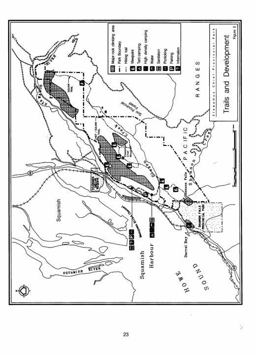
33 23
34 Actions: Expand the existing trail network to improve the trail system and create additional hiking opportunities. Improve signage on the existing trail network, i.e., incline, length and ruggedness. Upgrade all existing designated trails to park standards. Build facilities and trails to withstand recreational use and to minimize negative impacts on the natural environment and special features, i.e., erosion. Climbing The park is renowned for its rock climbing opportunities. There are several hundred routes providing climbing opportunities for both experienced and novice climbers. Climbing is becoming increasingly popular and use of the Chief is growing every year. Objectives: To provide for a variety of climbing opportunities. To minimize the impact on the environment. Actions: Develop a rock climbing strategy in conjunction with experienced rock climbers that addresses a number of issues, i.e., safety, code of conduct, route locations, facilities and signing. Identify and maintain/monitor access trails to the various starting points for climbers. 24
35 Climbers on the Chief Camping The base of the Chief has been used as an informal campground for almost 30 years. This camping area with only primitive facilities has received a high degree of impact from users. Currently there are three campgrounds in the area that will serve other camping needs, i.e., vehicle access; Klahanie and Dryden Creek are both privately operated, and Alice Lake Provincial Park. Objectives: To provide limited overnight camping opportunities in the park for park visitors. To minimize the impact of camping on the environment in the park and to improve health standards and sanitation facilities. Actions: Develop a campground that emphasizes low impact, walk-in access, rustic camping and limited vehicle high density campsites. Restrict camping to only designated campsites and all open fires will be prohibited. Special consideration may be given to camping outside designated areas by the District Manager. 25
36 Viewing and Picnicking Many people enjoy the views over Howe Sound and watch the climbers from the Highway 99 parking lot. The area adjacent to this parking lot with picnic tables also provides the opportunity to watch the climbers and it gives a view of the Chief. Objective: To maintain and enhance the day use opportunities in the park, especially in places which afford excellent vistas. Actions: Provide picnic tables and benches within the development zones. Enhance the views from the picnic areas in order to provide ongoing viewing opportunities. Provide access to the picnic and viewing areas within the development zones for people with special needs. Viewpoint from Second Summit 26
37 Safety and Risk Rock climbing and hiking are recreation opportunities requiring special attention to safety. There are significant inherent risks in the park from both rock climbing and hiking, and each year some rescues are necessary. The public should be well informed about the risks associated in using this park. It is important that these safety and risk issues be prominently addressed and that park hazards are identified. Objectives: To improve general safety conditions for park users. To focus on establishing guidelines for an acceptable level of risk by park users. Educate park users and the public on safety and risk aspects associated with the park. Actions: Develop a risk assessment, risk strategy, and prepare a safety and rescue plan in conjunction with Squamish Search and Rescue and other organizations. Improve the main road in the park so it can be accessed by emergency vehicles. Install an emergency telephone. Develop a public information strategy that identifies safety and risk hazards to the public, i.e., signage, brochures. Access Strategy There are four main accesses to the park. From the south, there is a trail from the parking lot of Shannon Falls; from the west, there is a gravel road from the Chieftain viewpoint. Access to the Apron parking lot northwest of the park is provided through the Mamquam forest road. This road also provides access to the Shannon spur (access for 4 wheel drive vehicles only). Objective: To allow for visitors to experience the park while minimizing effects on the environment, wildlife and visitors enjoyment of the park. 27
38 Actions: Control vehicle use, other than emergency vehicles, through the use of gates within the park. Provide additional parking facilities for visitors at the Apron, the Chief trailhead and the Chieftain viewpoint reststop. Deactivate all vehicle access points to the park not required for park purposes. Liaise with the Ministry of Transportation and Highways on future park access and potential Highway 99 development actions. BC Parks will participate with other government agencies concerning public transit access to the park and regional parking opportunities. Access to the park will not be encouraged through the Stawamus watershed. Interpretation and Education There are a number of interpretive themes that can be developed for Stawamus Chief Provincial Park in order to enhance public understanding and awareness about the park s resources. The park s wildlife, vegetation, special feature and cultural values offer numerous opportunities for interpretation. BC Parks will work with the Squamish First Nation and the Squamish community to develop the content of interpretive material and to determine the potential for joint participation in interpretive programs. Objectives: To inform the public about the environmental, natural and cultural values of the park. To enhance awareness of the natural and cultural resources in the park. To promote the principles of carrying capacity and risk management to protect the park s resources. Actions: Design and develop an interpretive strategy to enhance public awareness concerning the environmental, natural and cultural values in the park. Encourage schools and youth groups to visit the Stawamus Chief and learn about the park s special features and natural, cultural and recreational values. 28
39 Investigate the development of an interpretation centre relating to the Squamish First Nation cultural heritage in the Stawamus Chief area. Information Strategy Providing current information about provincial parks is an important aspect of visitor services. In Stawamus Chief Provincial Park, information serves a number of functions; however, there is no need for promotional strategies to increase park use. Objectives: To inform the public about safety and risk issues in the park. To inform the public about the park system and the regional recreation opportunities. Actions: Provide information signs where needed in the park. Provide signs/brochures to inform the public about park regulations, rock climbing safety, and other recreational opportunities in the area. Provide information in the form of maps and signage about the ruggedness and steepness of the trails and the level of fitness required to hike the trails. Trail to the Summits of the Chief 29
40 Marketing and Promotion The image of Stawamus Chief Provincial Park results from its outstanding and unique experiences based on its special feature, the Stawamus Chief. Stawamus Chief Provincial Park is already highly used with a growing number of visitors and users in a relatively small area. With this in mind, marketing and promotion of Stawamus Chief Provincial Park should be confined. Several local and regional organizations, i.e., Chamber of Commerce and visitor info, provide information about the Stawamus Chief. Objective: Promotion of Stawamus Chief Provincial Park will be low key. Actions: For the present, there will be no marketing and promotion of the park. Work with rock climbing associations, outdoor recreation groups and local organizations to promote other significant recreation opportunities in the area. Management Services Stawamus Chief Provincial Park is administered from BC Parks Garibaldi District Office at Alice Lake Provincial Park. The park s staff will ensure that various management responsibilities are carried out according to the Park Act and its regulations, this Management Plan and the established policies and procedures of the Ministry. Volunteers, Stewardship and Partnerships Objective: To develop relationships and partnerships with the public, volunteers, contributing partners and local governments which will ensure the long term protection of the natural and cultural resources and the delivery of park services, and provide facilities recommended in this Management Plan. 30
41 Actions: Develop a cooperative park stewardship agreement with an organized group that will assist BC Parks in securing resources to achieve the objectives of this Management Plan and future Annual Management Plans through donations, project grants and volunteer services. Establish an ongoing Advisory Committee to provide input for Annual Management Plans, research projects and other park-related issues as required. Assist Park Stewards to play a key role in fostering support for the park, coordinating volunteers and encouraging contributing partners to provide funding, sponsorship, expertise, research and other required services. Work closely with existing and potential new volunteer organizations to encourage them to continue their role in the provision of volunteer trail management. Commercial Activities Rock climbing guiding and hiking have been the traditional commercial recreation services in the park. Ancillary services such as a laundromat, grocery, equipment/supplies, store/gift shop, etc., will not be permitted in the park. These services are currently found or will be provided nearby in the Squamish area. Objective: To encourage commercial recreation services that are in keeping with the role of Stawamus Chief Provincial Park. Actions: Non-mechanized guiding in the park will be encouraged. Rock climbing guiding, hiking, and nature interpretation will continue to be commercial recreation services offered on the Stawamus Chief. Climbing guides shall adhere to the accepted industry standards guidelines, procedures and recommendations with respect to guiding in the park. Educational guiding and tours will be encouraged. 31
42 PLAN IMPLEMENTATION Introduction This section compiles all of the actions listed throughout this Management Plan and lists them in order of priority. Implementation of these actions is dependent upon the availability of BC Parks financial and staff resources, and will be affected by the needs of other parks in the Garibaldi/Sunshine Coast District and in the rest of the BC Parks system. Approval of this plan does not constitute automatic approval of funding for implementation. In addition, BC Parks may have to seek corporate, community or interagency partnerships to implement many of the actions listed in this plan. Prioritizing of the main resources and visitor management proposals is necessary to effectively implement this five to ten year Management Plan. The following outline lists the proposed actions in three sections: Highest Priority Actions, Task or Project Oriented Actions, and Ongoing and Monitoring Actions. The first list, Highest Priority Actions, highlights actions that are of the highest priority and require attention within the near future. The second list, Task or Project-Oriented Actions, highlights actions that require a specific task or project. Park managers will review this list for upcoming budgets and annual work plans for staff. This list is separated into Resource Management actions and Visitor Services actions. The third list, Ongoing Monitoring Actions, describes actions that require ongoing or monitoring types of tasks or projects. This list will be reviewed regularly by park managers to ensure that the overall spirit and intentions of this Management Plan are being followed. This list is also separated into Resource Management actions and Visitor Services actions. HIGHEST PRIORITY ACTIONS Continue to pursue land acquisition in the PAS study boundary as recommended in the Stawamus Chief Study Area Final Report (June, 1994). Discuss with Squamish First Nation areas of special spiritual and cultural interest it has identified and how BC Parks will recognize and protect those aboriginal cultural features found in the park. Develop a rock climbing strategy in conjunction with experienced rock climbers that addresses a number of issues, i.e., safety, code of ethics, route locations, facilities and signing. 32
43 Protect sensitive or unique vegetation and vegetation communities from future park development through zoning. Develop a risk assessment, risk strategy and prepare a safety and rescue plan in conjunction with Squamish Search and Rescue and other organizations. The park will be closed to hunting and all open fires will be prohibited. All forest fires in the park will be actively suppressed. In consultation with Squamish First Nation, identify the aboriginal rights that relate to the park and the areas in which they are practiced. Expand the existing trail network to improve the trail system and create additional hiking opportunities. Upgrade all existing designated trails to park standards. Design and develop an interpretive strategy to enhance public awareness concerning the environmental, natural and cultural values in the park. Develop a campground with sanitary facilities that emphasizes low impact, walk-in access, rustic camping and limited vehicle high density campsites. Install an emergency telephone. Establish an ongoing Advisory Committee to provide input for Annual Management Plans, research projects and other park-related issues as required. Rock climbing guiding, hiking and nature interpretation will continue to be commercial recreation services offered on the Stawamus Chief. Restrict camping to only designated campsites unless authorized for special purposes by the District Manager. Vehicle access to the park will not be encouraged through the Stawamus watershed. Liaise with Ministry of Transportation and Highways on future park access and potential Highway 99 development actions. 33
44 TASK OR PROJECT-ORIENTED ACTIONS Natural and Cultural Resources Management Ensure that a notation of interest on behalf of BC Parks is registered by BC Lands over those portions of Rock Work mineral claims found in the PAS study boundary. Not include those portions of Rock Work mineral claims found in the PAS study boundary and wait for the claims to lapse in which case it should then be designated as part of the protected area, or if the claim holder files for a mine/quarry lease, they will at that time have to show reason for holding those portions of the lease within the present study boundary. Develop a strategy with the Squamish First Nation that will protect and allow for the continued practice of traditional activities for present and future generations of First Nations people in relation to the lands within the park. Undertake a water quality survey. Develop a Vegetation Management Plan which includes a vegetation/plant species inventory. Protect sensitive or unique vegetation and plant communities from future park development through park zoning. Develop a long term Wildlife Management Plan with special attention to endangered species. Review and upgrade the existing inventory species list. Register and record peregrine falcon nesting sites as they become identified. Implement recreational closures in the immediate areas of active peregrine falcon nesting sites. Investigate the development of an interpretation centre relating to Squamish First Nation cultural heritage in the Stawamus Chief area. Develop new viewpoints with appropriate signing and day use facilities. Visitor Services Provide safety and information signs where needed in the park, i.e., steepness and ruggedness of trails, level of fitness required to hike the trails, and safety equipment. 34
45 Upgrade the existing trail system to BC Parks standards, improve trail signage and create additional hiking opportunities. Install picnic tables and benches within the development zone and provide access for people with special needs. Improve the main access road in the park so that it can be used by emergency vehicles. Develop a public information strategy that identifies safety and risk hazards to the public. Install park gates to control vehicle use and provide greater security for park campers. Deactivate all vehicle access points to the park not required for park purposes. Provide additional parking facilities for visitors at the Apron, the Chief trailhead and Chieftain viewpoint rest stop. Develop a cooperative park stewardship agreement with an organized group that will assist BC Parks in securing resources to achieve the objectives of this Management Plan and future Annual Work Plans through donations, project grants and volunteer services. ONGOING AND MONITORING ACTIONS Natural and Cultural Resources Management Monitor the park s water quality and determine appropriate actions to maintain its water quality. Olesen Creek will be used as a source of potable water for park users. Focus recreational activities in those areas of the park outside the Stawamus River drainage which is a source of potable water for the residents of Squamish. Rehabilitate areas that have been impacted by park users which may require periodic closures. Monitor hazardous trees and remove as required. Work with BC Hydro to ensure that its vegetation controls are in keeping with park values, i.e., no use of herbicides. Promote public education in order to increase awareness on protecting wildlife and their habitat. 35
46 Work with other agencies to consider visual impacts when approaching developments that affect the viewshed of Stawamus Chief Provincial Park. Visitor Services Construct facilities and trails to withstand recreational use and to minimize negative impacts on the natural environment and special features. Identify and maintain/monitor access trails to the various starting points for climbers in the park. Enhance the views from the picnic areas in order to provide ongoing viewing opportunities. Liaise with other provincial/municipal agencies concerning public transit access to the park and regional parking opportunities. Encourage schools and youth groups to visit the Stawamus Chief and learn about the park s special features and natural, cultural and recreational values. Provide safety and information signs where needed in the park. Inform the public about park regulations, rock climbing conduct and safety/risk factors when visiting the park. Monitor park use. For the present time, there will be no marketing and promotion of the park. Work with rock climbing associations, outdoor recreation groups and local organizations to promote other significant recreation opportunities in the area. Assist park stewards to play a key role in fostering support for the park, coordinating volunteers and encouraging partners to provide funding, sponsorship, expertise, research and other required services. Work closely with existing and potential new volunteer organizations to encourage them to continue their role in the provision of volunteer trail management. Non-mechanized guiding, i.e., educational/tour guiding in the park will be encouraged. Climbing guides shall adhere to the accepted industry standards, guidelines, procedures and recommendations with respect to guiding in the park. 36
47 APPENDIX A BC Parks Systems Goals The British Columbia Provincial Parks System has two mandates: to conserve significant and representative natural and cultural resources and to provide a wide variety of outdoor recreation opportunities. CONSERVATION GOALS Goal 1 Goal 2 Protection of Representative Ecosystems. The Provincial Parks System will include areas that are representative of the natural ecosystems of British Columbia, thereby protecting and presenting for posterity, the characteristic combinations of flora, fauna, landforms and waters associated with this diverse province. Protection of Outstanding Special Features. The Parks System will contain a wide scenic selection of the best provincial outdoor recreation resources, natural features, wilderness areas and historic resources of British Columbia. RECREATION GOALS Goal 1 Goal 2 Goal 3 Goal 4 Outdoor Recreation Holiday Destination Opportunities The Provincial Parks System will include appropriate outdoor recreation lands and facilities providing for the use and enjoyment of major outdoor recreation destinations in British Columbia. Tourism Travel Route Opportunities The Provincial Parks System will include, as a complement to other suppliers, outdoor recreation lands and facilities in association with major provincial travel corridors to ensure that travelling vacationers are supplied with a basic network of scenic stopoffs. Regional Recreation Opportunities The Provincial Parks System will include, as a complement to other suppliers, land and facility-based opportunities for outdoor recreation distributed in association with British Columbia s natural geographic regions in order that British Columbians are assured a basic supply of outdoor recreation services close to home. Backcountry Recreation Opportunities We want to build the province s reputation for backcountry recreation by protecting and managing our most outstanding wilderness areas. Some sites may feature adventure tourism, while in other areas the wilderness would remain untouched. 37
48 APPENDIX B BC Parks Zoning Policy Below are descriptions of the various zones that can be applied in provincial parks. The lists of activities and facilities shown for each zone indicate what could occur and not necessarily what must occur. In many parks, only a few of the activities or facilities shown in the list would occur. INTENSIVE RECREATION ZONE Management Objective To provide a variety of high-use, readily accessible, facility-oriented outdoor recreation activities. Activities Camping, picnicking, beach activities, power boating, nature appreciation, skiing, fishing. Facilities May be intensely developed, i.e., campgrounds, play areas, interpretive buildings, boat launches. NATURAL ENVIRONMENT ZONE Management Objective To provide a variety of easily-accessible off-road outdoor recreation activities in a largely undisturbed natural environment. Activities Walk-in camping, kayaking, cross-country skiing, horseback riding. Facilities Moderately developed, i.e., trails, wilderness/boating campsites, shelters. SPECIAL FEATURE ZONE Management Objective To protect and present significant natural or cultural resources, features or processes because of their special character, fragility and heritage value. 38
49 Activities Sightseeing, interpretation and study of history and nature. Facilities May be developed for feature interpretation purposes. May be subject to temporary closures or permanently restricted access. WILDERNESS RECREATION ZONE Management Objective To provide backcountry recreation in a remote natural environment, with emphasis on a wilderness atmosphere. Activities Backpacking, river rafting, fishing, hunting, nature appreciation. Facilities Development limited to user convenience and protecting the environment, i.e., trails, primitive campsites, shelters. Mechanized access may be allowed to specific points. WILDERNESS CONSERVATION ZONE Management Objective To protect a remote, undisturbed natural landscape and provide backcountry experiences based on a pristine environment where no motorized activities will be allowed. Activities Backpacking, river rafting, fishing, nature appreciation. No hunting and No mechanized access allowed. Facilities No development. 39
50 APPENDIX: C Plant List List of plants that were inventoried in June and July, 1996 in Stawamus Chief Provincial Park. Acer macrophyllum Acer glabrum Acer circinatum Achillea millefolium Adiantum pedatum Agropyron trachycaulum Alnus rubra Amelanchier alnifolia Anaphalis margaritacea Aquilegia formosa Arnica amplexicaulis Anurcus dioicus Asplenium viride Athyrium filix-femina Betula papyrifera Blechnum spicant Calamagrostis canadensis Campanula rotundifolia Carex laeviculmis Carex lyngbyei Carex rostrata Carex mertensii Carex spp. Castilleja miniata Chimaphila umbellata Chimaphila menziesii Chrysanthemum vulgare Cladina spp. Cladina portentosa Cladothamnus pyroliflorus Claytonia sibirica Clintonia uniflora Corallorhiza maculata spp. mertensiana Cornus canadensis Cystopteris fragilis Cystisus scoparius Big Leave Maple Douglas Maple Vine Maple Yarrow Maidenhair Fern Slender Wheatgrass Red Alder Saskatoon Pearly Everlasting Red Columbine Streambank Arnica Goat s Beard Green Spleenwort Lady Fern Paper Birch Deer Fern Bluejoint Common Harebell Smooth Sedge Lyngby s Sedge Beaked Sedge Merten s Sedge Sedge Common Red Paintbrush Prince s Pine Menzies Pippissewa Oxeye daisy Lichen Coastal Reindeer Copperbush Candy Flower Queen s Cup Western Coralrood Dwarf Dogwood Fragile Fern Scotch Broom 40
51 Dicentra formosa Digitalis purpurea Drosera rotundifolia Dryopteris expansa Epilobium angustifolium Equisetum arvense Eriophorum angustifolium Eriophyllum lanatum Festuca occidentalis Galium triflorum Gaultheria ovalifolia Gaultheria shallon Geum macrophyllum Goodyera oblongifolia Holodiscus discolor Hylocomium splendens Hypericum perforatum Hypochaeris radicata Ilex agifolium Juncus spp. Kindbergia oregana Lactuca muralis Ledum groenlandicum Lilium columbianum Linnaea borealis Listera cordata Lonicera involucrata Lycopodium clavatum Lysichiton americanum Mahonia nervosa Menziesia ferruginea Nuphar polysepalum Oplopanax horridus Oxycoccus oxycoccos Pachistima myrsinites Penstemon davidsonii Phleum pratense Physocarpus capitatus Pinus monticola Pinus contorta var. contorta Plagiochila porelloides Pleurozium schreberi Polypodium glycyrrhiza Polystichum munitum Pacific Bleeding Heart Common Foxglove Round Leaved Sundew Spiny Wood Fern Fireweed Common Horsetail Narrow leaved Cotton Grass Woolly Eriophyllum Western Fescue Sweet Scented Bedstraw Western Tea berry Salal Large Leaved Avens Rattlesnake Plantain Oceanspray Step moss Common St. John s Wort Hairy Cat s ear Holly Rush Oregon Beaked Moss Wall Lettuce Labrador Tea Tiger lily Twinflower Heart-leaved Twayblade Black Twinberry Running Clubmoss Skunk Cabbage Dull Oregon Grape False Azalea Yellow Pond Lily Devil s Club Bog Cranberry Falsebox Davidson s Penstemon Tymothy Pacific Ninebark Western White Pine Shore Pine Cedar Shake liverwort Red Stemmed Feathermoss Licorice Fern Sword Fern 41
52 Polytrichum spp. Populus balsamifera ssp. trichocarpa Prunella vulgaris Prunus emarginata Pseudotsuga menziesii Pteridium aquilinum Pyrola asarifolia Quercus spp. Ranunculus repens Rhytidiadelphus loreus Ribes lacustre Rosa nutkana Rubus leucodemis Rubus parviflorus Rubus spectabilis Salix spp. Sambucus racemosa ssp. pubens Saxifraga ferruginea Smilacina racemosa Smilacina stellata Sorbus sitchensis Sphagnum papillosum Spiraea douglasii ssp. douglasii Thuja plicata Tiarella trifoliata var. unifoliata Tofieldia glutinosa Trientalis latifolia Trientalis arctica Trifolium pratense Tsuga heterophylla Vaccinum caespitosum Vaccinum parvifolium Viola langsdorfii Haircap Moss Black Cottonwood Self Heal Bitter Cherry Douglas-fir Bracken Fern Pink Wintergreen Oak Creeping Buttercup Lanky Moss Black Gooseberry Nootka Rose Black Raspberry Timbleberry Salmonberry Willow Red Elderberry Alaska Saxifrage False Solomon s seal Star Flowered False Solomon s Seal Sitka Mountain Ash Fat Bog Moss Hardhack Western Red Cedar Foamflower Sticky False Asphodel Broad leaved starflower Northern Starflower White Clover Western Hemlock Dwarf Blueberry Red Huckleberry Alaska Violet 42
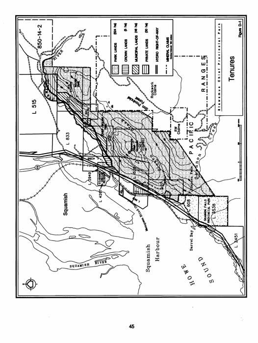
53 APPENDIX D Stawamus Chief - Schedule All those parcels or tract of Crown land, together with all that foreshore or land covered by water, situated in New Westminster District and lying within the following described boundaries: 1. Lot "E" of District Lot 608, Plan 10467; 2. Lot "A" of District Lot 2177, Group 1, Explanatory Plan 11467; 3. That part of District Lot 1520, Group 1, Reference Plan 11534; 4. All that portion of District Lot 4266, Group 1, south of the Mamquam Forest Service Road (FSR BR01); 5. All that portion of Lot 1, Blk E of District Lot 912, Plan 13853, south of the Mamquam Forest Service Road (FSR BR01); 6. Commencing at the southwest corner of Lot "A" of District Lot 2177, Explanatory Plan 11467; thence easterly and northerly along the south and east boundaries of said Lot "A" to the southerly boundary of District Lot 1520; thence easterly and northerly along the southerly and easterly boundaries of District Lot 1520 to the southeast corner of District Lot 4266; thence northerly along the easterly boundary of said Lot to the south west corner of District Lot 912; thence easterly and northerly along the southerly and easterly boundaries of said Lot to the south west corner of District Lot 7041; thence easterly and northerly along the southerly and easterly boundaries of District Lot 7041 to the southerly boundary of District Lot 833; thence easterly along the southern boundary of District Lot 833 to the south east corner thereof; thence easterly along the southern boundary of District Lot 7032 to the south east corner thereof; thence easterly and northerly along the easterly boundaries of District Lot 7032 to the southerly boundary of District Lot 515; 43
54 thence easterly and northerly along the southerly and easterly boundaries of District Lot 515 to the natural boundary of Stawamus River, on the south bank thereof; thence in an easterly and southeasterly direction along said natural boundary to the intersection with the most easterly southerly boundary of the Municipality of Squamish; thence west along the said Municipal boundary; thence south along the easterly boundary of the Municipality of Squamish to a point, said point being due east of the south east corner of District Lot 7041; thence west a distance of 1.19 km; thence due south a distance of 1.36 km; thence southeasterly a bearing of a distance of 409m; thence due west a distance of 337m; thence due south a distance of 484m; thence due west a distance of 223m; thence due south a distance of 184m; thence south westerly in a straight line to a point on the easterly boundary of District Lot 3538, said point being 300m north from the southeast corner of said Lot; thence northerly along said easterly boundary to the intersection with the southerly boundary of District Lot 608; thence easterly and northerly along the southerly and easterly boundaries of District Lot 608 to the southwest corner of Lot "A" of District Lot 2177, being the point of commencement. Save and except thereout the following: 1) The "Mamquam" Forest Service Road (FSR BR 01) 2) BC Hydro Right-of-Way through Lot "A" of District Lot 2177 and that portion of District Lot 1520 as shown on Reference Plan 5487 The whole containing approximately 528 hectares. 44
55 45
56 S TAWAMUS CHIEF S TUDY AREA FINAL REPORT June, 1994 Recommendation to R.P.A.T. from Study Team
57 TABLE OF CONTENTS Page LETTER OF TRANSMITTAL...i STAWAMUS CHIEF STUDY TEAM...ii SUMMARY...iii HIGHLIGHTS...iv STAWAMUS CHIEF REGIONAL CONTEXT...v 1. INTRODUCTION Stawamus Chief as a Study Candidate The Process RESOURCES IN THE STAWAMUS CHIEF STUDY AREA Physiography and Geology Climate Ecoregions and Biogeoclimatic Zones Access and Land Status Water Resources Timber Resources Mineral Resources Aboriginal Values Wildlife Resources Special Features and Natural Landscapes Recreation Resources Visual Resources RESOURCES AND PROTECTED AREA STRATEGY CRITERIA PAS GOAL PAS GOAL RECOMMENDATIONS Options Considered...19 Option A - Status Quo...19 Option B - Designation of all or part as a Protected Area under the Park Act...20 Option C - Joint Management Committee Recommendations...23
58 Table of Contents cont. 5. SOCIO-ECONOMIC VALUES SUMMARY OF PUBLIC REVIEW...28 APPENDICES APPENDIX A - Birds Detected in the Summer of 1991 Stawamus Study APPENDIX B - Stawamus Chief Study Area Terms of Reference APPENDIX C - Public Comments APPENDIX D - Matrix to Assess Options APPENDIX E - Whuch-Tall (Squamish Nation) Legend LIST OF FIGURES Figure 1 Stawamus Chief Study Area...1 Figure 2 Stawamus Chief Land Status...5 Figure 3 Stawamus Chief Mineral Claims...8 Figure 4 Stawamus Chief Recreation...11 Figure 5 Stawamus Chief - Southern Pacific Ranges Ecosection...14 Figure 6 Stawamus Chief Study Area Recommendation...25
59
60
61 iii SUMMARY The Stawamus Chief study area is relatively small and contains approximately 700 hectares of Crown and private lands immediately to the south of the town of Squamish. Lying partially within the Soo Provincial Forest, the District M unicipality of Squamish and the Squamish- Lillooet Regional District, the study area is renowned for its freestanding granite monoliths that provide some of the best rock climbing opportunities in the world. The Stawamus Chief area has been the focus of much interest for outdoor recreation groups such as the Federation of Mountain Clubs of British Columbia who wish to see the area preserved and left in a relatively natural state. BC Parks Plan 90 Special Features for BC Parks report identified the Stawamus Chief as an outstanding, provincially significant special feature of igneous rock. The variety of users who hold an interest in the area also include the Squamish Rock Climbers, Squamish Nation, local government and businesses, hikers, rock climbers, photographers, nature enthusiasts and the travelling public. It is estimated that over 160,000 people enjoyed the Chieftain viewpoint in 1993 and approximately 360,000 visited Shannon Falls Provincial Park which lies immediately to the south of the study area. Since 1989 when the Granite Monoliths of Squamish report was written through Parks Plan 90 and now a part of the Protected Areas Strategy (PAS) process, the Stawamus Chief area has been identified as having significant recreation and cultural values. In 1992 the Stawamus Chief study (SCS) team was formed to determine the area s significance and make recommendations to senior government - Regional Protected Areas Team (RPAT) on future land designation and protection of this Southern Pacific Range CWHdm (Coastal Western Hemlock dry maritime) ecosection candidate. The SCS team used a process of consensus to prepare this report. The recommendation of the SCS team is presented with the intent that the long term objective would be to designate the Stawamus Chief area as a protected area. This recommendation is a slight variation of Option B (Park Option) which was presented to the public in the fall of This park designation option received the most public support and an analysis of public comments received from both questionnaires and meetings is found in Appendix C. The most suitable classification, at this time, is Class A Provincial Park designation. However, in making this recommendation the study team recognizes that because of the variety of land tenures and ownerships within the study area and financial implications in acquiring any privately owned lands, not all recommendations will be achieved, at least, in the short term. The study team recommends that all vacant Crown lands and Provincial Forest land within the study area be designated as Class A park subject to certain conditions. Other major points recommended in order of priority for designation and acquisition are listed in Section 4.2 of the report.
62 iv HIGHLIGHTS The Stawamus Chief is one of the largest, freestanding granite monoliths and offers spectacular views, excellent hikes and first rate rock climbing opportunities. The Squaw, The Apron, Malemute and Papoose Bluff combine with the Chief to make this area one of the world s foremost climbing centres readily accessible to a major urban catchment. The Stawamus Chief study area comprises some 700 hectares and is located adjacent to Highway 99, immediately to the south of downtown Squamish and north of Shannon Falls Provincial Park. In 1992 over 159,000 people visited the Chieftain viewpoint which is located at the base of the Chief. The Stawamus Chief was identified as an outstanding, provincially significant special feature of igneous rock in BC Parks Plan 90 Special Features for BC Parks report. There are a number of private and public lands within the study area. The Crown is the principle land owner with approximately 497 hectares including the top of the Chief. The Stawamus Chief study area lies partially within the Soo Provincial Forest which is under the management of the Squamish Forest District. Nearly half of the study area has been logged and only moderate to poor forestry values exist today. The Ministry of Energy, Mines and Petroleum Resources states that the dimension stone potential of the study area has not been fully addressed but there may be sites in the area already identified. The Squamish Nation has identified the Stawamus Chief as having significant historical and cultural value to its people. The Stawamus Chief study area is within the area which is presently subject to the Squamish Nation s claim of Aboriginal Title. A pair of peregrine falcons nest on the face of the Chief and voluntary climbing closures of these known sites are observed by climbers during the nesting season. The focal view of the Chief is provincially and possibly nationally significant. The Chief and other local granite monoliths are important tourist values representing the most distinctive and significant visual resources for businesses and residences in Squamish. The panoramic view from the Chief over Howe Sound and Squamish is outstanding. In addition to the many recreation opportunities associated with the study area, there are also commercial activities (ie. guiding, climbing) that provide both local and regional employment opportunities.
63 v

64 1 1. INTRODUCTION The Stawamus Chief is the dominant natural feature of the District of Squamish and includes a series of peaks located on a pronounced ridge between the Stawamus River and Olesen Creek. The Squaw, The Apron, Malemute Bluff and Papoose Bluff are prominent components that combine with the Chief to make the area one of the world s foremost climbing centres readily accessible to a major urban catchment. This impressive landscape is a major attraction, not only for rock climbers and hikers, but for tourists travelling scenic Highway 99, the Sea to Sky Route. It has been estimated that the Olesen Creek trail leading up to the three summits of the Chief attracts approximately 500 visitors per day on summer weekends. The Granite Monoliths report (1992 Squamish recreation users survey) estimates that there may be as many as 50,000 hiker and 25,000 rock climbers annually.
65 2 Nearby to the south is Shannon Falls located adjacent to Shannon Falls Provincial Park. Rising some 335 metres, it is the third highest waterfall in B.C. and a spectacular landmark in its own right. Shannon Falls attracts hundreds of thousands of visitors each year, both from the Vancouver region and abroad. The Stawamus Chief study area is comprised of public lands (Provincial Forest, Recreation Reserve, District of Squamish lands etc.) and private lands. As well, there are various encumbrances including railway, highway and hydro rights-of-ways and mineral claims. This area has been identified by the Squamish Nation as having significant historical and cultural value to their people and is currently subject to a land claim of Aboriginal Title. In 1989, the Federation of Mountain Clubs of B.C. prepared a report on the Granite Monoliths of Squamish. This report provided an excellent background on the values of the Stawamus Chief Study area as it pertains to recreation opportunities. After the production of that report a Granite Monolith Committee was established made up of numerous government agencies, local government and recreational interest groups who provided recommendations on the management of this area. Out of these recommendations, a Ministry of Forest map notation was placed on the Provincial forest lands within the Study area and several land reserves were put in place by BC Lands at the request of the Ministry of Municipal Affairs. The private lands falling within Municipal boundaries have been designated for recreation/open space in the District of Squamish Official Community Plan. The Granite Monolith Committee recommended that one agency take on the role as lead agency in the management of this area but that did not happen as there was a decision to wait for the results of the Parks and Wilderness Plan for the 90's process. BC Parks is now leading this study area process which is comprised of a variety of government and non-government agencies including some special interest groups. 1.1 Stawamus Chief as a study candidate Renowned for its exceptional rock climbing and visual qualities, the Stawamus Chief area also marks the gateway to the District of Squamish and the Whistler-Pemberton corridor. Overlooking the head of Howe Sound, this area is typical of the vegetation and geography associated with the Southern Pacific Ranges Ecosection. The granite walls of the Chief and surrounding bluffs attract rock climbers from around the world and is a major tourist feature for the District of Squamish. This area is also popular for hiking, attracting both local and regional users who enjoy the numerous trails and breathtaking views. In 1992, over 159,000 people visited the Chieftain Viewpoint which is located at the base of the Stawamus Chief adjacent to Highway 99 while over 357,000 visited neighbouring Shannon Falls Provincial Park. In addition, the Stawamus Chief area provides an important part of Squamish s economic base by benefitting various restaurants, retailers, accommodation facilities and recreation-oriented businesses.
66 3 Local residents enjoy the recreation features associated with the Stawamus Chief which is right in their backyard. As well, the Squamish Nation has identified the importance of this area for its historic and spiritual values. Highway 99, the Sea to Sky highway, is attracting more and more tourists who want to see the route s many impressive natural features such as the Stawamus Chief. Whistler has become an international alpine ski destination and is also encouraging year round recreation enthusiasts to visit the area. North of Whistler, the town of Pemberton is a major stop along the Nugget Route, a historic highway touring loop from Vancouver to Lillooet utilizing Highway 99, the Duffy Lake Road and Highway 1. BC Parks statistics show that there are 1.8 million annual visits to provincial parks in Sea to Sky country of which over 1.6 million are day use visitors; 100,000 are campers; and 1,235,000 visited only provincial parks in the Howe Sound area. 1.2 The Process Identified as an area of interest through the Protected Area Strategy (PAS) process, the Stawamus Chief Study Area is under review to determine if it meets the selection criteria. If this criteria is met the study team is also meant to make recommendations on the area's future land designation, such as provincial park, wilderness area, ecological reserve, etc., and management of its natural features and outdoor recreation opportunities. A Study Team, chaired by BC Parks was formed in August of 1992 to review and make recommendations to the Regional Protected Area Teams (RPAT) on the area s future land designations. During the following year the study team met regularly to discuss issues relating to the study area and review a draft Background Report compiled by Jim Morris, BC Parks. Study team members representing the District Municipality of Squamish, Squamish-Lillooet Regional District, Squamish Chamber of Commerce, Squamish Nation, Ministry of Environment, Lands and Parks, Ministry of Forests, Ministry of Energy, Mines and Petroleum Resources, Federation of Mountain Clubs of BC, Squamish Rock Climbers Association, Squamish Community Forest and others all provided input to the Background Report. Public Open Houses were held in North Vancouver and Squamish in August and September, 1993 to present the Draft Background and obtain public comments on the proposed land designation options. In addition, information displays describing the study area and process were erected at the Chieftain viewpoint parking lot, Squamish Municipality Hall, Squamish Art Gallery, The Edge Climbing Centre and presented at the Open Houses and various club meetings. A summary of public comments (refer to Appendix) was developed and reviewed by the study team and provided sufficient data to give support to the study team s enclosed recommendations to RPAT.
67 4 2. RES OURCES IN THE S TAWAMUS CHIEF S TUDY AREA 2.1 Physiography and Geology The Stawamus Chief is part of a large granitic intrusion that was cut by northeasterly trending fractures prior to uplift as a part of the mountain building process. The topography of the area has a pronounced northeasterly orientation, as a result of preferential erosion of fractured rock. A large glacier, flowing down the Stawamus River Valley, gouged out the face of the Chief and a small, alpine glacier on it s south side created the hanging valley now occupied by Olesen Creek. 2.2 Climate The climate in this area is typical of the south coast with mild wet winters and warm sunny summers. Mean average daily temperatures range from 23 degrees Celsius in July to 4 degrees in January, with a May to September summer season mean of 15 degrees Celsius. Precipitation averages approximately centimetres annually. 2.3 Ecoregions and Biogeoclimatic Zones The Stawamus Chief study area lies within the Pacific and Cascade Ranges ecoregion which typically has high rugged mountains and a wet maritime climate. More specifically, it is representative of the Southern Pacific Ranges ecosection (SPR). Vegetation is representative of the Drier Maritime subzone of the Coastal Western Hemlock Biogeoclimatic Zone (Krajina, 1974). Vegetation has been modified due to logging and fires. The study area is forested primarily with characteristic CWH zone species including Douglas-fir (Pseudotsuga menziesii), western hemlock (Tsuga heterophylla), western red cedar (Thuja plicata) and successional species including red alder (Alnus rubra), willow (Salix sp.), huckleberry (Vaccinium sp.) and salal (Gaultheria shallon). 2.4 Access and Land Status Regionally, the Stawamus Chief area is located adjacent to Highway 99, immediately to the south of downtown Squamish and north of Shannon Falls Provincial Park (Figure 2). The scenic drive from Horseshoe Bay to Squamish is highlighted by Shannon Falls and the massive granite walls of the Chief, Squaw and Malemute. The Stawamus Chief study area, comprising some 700 hectares, is located partially within the District of Squamish adjacent to Shannon Falls Provincial Park which was established as a Class A park in A portion of the study area is within Electoral Area D of the Squamish-Lillooet Regional District. This area is presently unzoned and the Regional District does not have a park function.

68 5 The Stawamus Chief study area contains a number of private and public lands. A large area in the eastern portion of the study area lies within the Soo Provincial Forest. A recreation reserve established by BC Lands covers the entire summit area of the Chief and a Ministry of Forests map reserve is designated over the entire eastern section of the study area. The study area which includes Shannon Falls also adjoins Shannon Falls Provincial Park. The Crown is the principle land owner with approximately 497 hectares including the top of the Stawamus Chief. The District of Squamish holds title to a number of land parcels in the northwest section of the study area. In addition, BC Rail, Western Forest Products and Amen Lands Ltd. are the major private landowners. The summit and backslope portions of Stawamus Chief are within a Crown land recreation reserve. However, many of the significant climbing routes, landmark rock faces, trailheads and parking areas are on private lands. The District of Squamish owns some of the land at the base of the Chief. The Saddle, including Squamish-facing slopes, is within the provincial forest.
69 6 Malemute Bluff, on the west side of Highway 99, is privately owned. In addition, as the bluff commences at the near tidewater level of the railway line, climbers utilize the BC Rail route as an access avenue to its base. At Shannon Falls, while the land at the base of the falls is contained within a provincial park, the falls itself and associated granite rock faces are outside the park. These resources are contained within the Soo Provincial Forest. Papoose Bluff was added to Shannon Falls Provincial Park in The base of the bluff is located within the Highway 99 right-of-way, and rights-of-way for hydro-electric transmission lines virtually surround the bluff. The participation and commitment of all landowners within the study area is crucial to the success and implementation of the study findings. Several key areas are privately owned, as indicated on Figure 2, including the following: - rock climbers parking lot and campground, - Olesen Creek trailhead and a portion of the trail, - numerous popular and well-used rock climbing areas such as the Apron, Grand Wall, Western Dihedrals and the Malemute. Two utility corridors traverse the study area: BC Hydro s right-of-way and transmission line; and Ministry of Transportation and Highways Route 99 and its right-of-way. BC Hydro has restrictive covenants over their rights-of-way that restrict development. Brush control is also required on these rights-of-way and BC Hydro may consider special management techniques that will not adversely affect other values in the area, ie. manual brush control versus spraying. Trail access to the Stawamus Chief area is usually from the main parking area located adjacent to Highway 99 at the base of the Chief. It takes a hiker less than two hours on average to reach the top of the Chief where panoramic views of Howe Sound and the surrounding Squamish area can be enjoyed. This main trailhead parking area also serves to access the Malemute which is located on the other side of the Highway 99. Another trail access route to the Chief s summit trails is from Shannon Falls Provincial Park day use area parking lot. Hikers can reach the Stawamus Chief/Olesen Creek trails in fifteen minutes along the Shannon Falls trail. Portions of these trails have deteriorated due to heavy public use and erosion. The North Shore Hikers Club has adopted the main trail under the FMCBC Adopt-A-Trail program and is providing yearly volunteer maintenance. The Mamquam and Stawamus-Indian Arm Forest Service roads currently provide access to the backside of the Chief along the BC Hydro right-of-way and a trail follows Olesen Creek to meet up with the main trail. These rough gravel roads takes 4 wheel drivers about 20 minutes after leaving the highway to reach the Olesen Creek trailhead.
70 7 Road access management is currently being reviewed under the Stawamus-Mashiter Integrated Water Management Plan (IWMP) process led by the Ministry of Forests. The Ministry of Transportation and Highways (MOTH) may eventually be enlarging Highway 99 to a four-lane route. This could create a need to address specifics with parking and both lefthand and righthand turn lanes to provide access which should not create an overall hindrance to the long term management of this area. 2.5 Water Resources The Stawamus Chief study area covers portions of three watersheds. These include the Stawamus River which forms the northern boundary of this study area and is a primary water source for the District of Squamish as a domestic water supply (subject to an IWMP which is currently under study). Olesen Creek, which also lies within the centre of the study area provides recreationists a primary water source when hiking along the stream before experiencing the strenuous climb up the main trail to the summits of the Chief and Squaw. Near the southern boundary, Shannon Creek is the source of the spectacular cascading waterfall known as Shannon Falls. Adjacent to this waterfall is Shannon Falls Provincial Park where park visitors can enjoy viewing this special feature. Shannon Creek also provides the water supply for the many day users at this park. 2.6 Timber Resources The Stawamus Chief study area lies partially within the Soo Provincial Forest which is under the management of the Squamish Forest District. Due to the area s environmental sensitivity, terrain and vegetation, the forest values and forest productivity tend to be low on average. Almost half of the study area has been previously logged and is now a mixture of scrubby coniferous and deciduous second growth vegetation. There are, however, some moderate to poor commercial value stands distributed among the assortment of lands owned by a variety of public and private interests. During the 1992 winter season, a blowdown timber salvage operation was conducted by helicopter on the east side north of Shannon Creek. This area was restocked in the fall of 1993 with Douglas-fir and western red cedar. The study area would contribute annually approximately 576 cubic metres (19 logging truck loads) to the allowable annual cut of the Soo timber supply area (TSA). Containing Douglas-fir, western red cedar, western hemlock, lodgepole pine and yellow cedar, less than 20 percent of the study area is capable of growing commercially valuable timber on a sustained yield basis. Most of this sustainable forest land is within the Crown land portions of the study area.

71 8 Using a factor of $200 m3, the value to the BC economy of a 576 m3/year timber harvest would be approximately $115,000 annually. This harvest would support slightly less than one direct full time job and two indirect and induced full time jobs. 2.7 Mineral Resources The Stawamus Chief study area is underlain by relatively homogenous, unaltered granite rock. There are no known mineral deposits and the Ministry of Energy, Mines and Petroleum Resources (EMPR) reports that there is a relatively low probability of finding an economically viable metallic mineral deposit. The granite rocks, however, display many of the characteristics of good quality dimension stone and EMPR believes that there is excellent potential for developing dimension stone quarries in the vicinity of Squamish. In 1990 the ministry commissioned a review of potential quarry sites along the southern coast. The review identified several possible sites in and around Squamish. One site was identified in the study area on private land at Malemute Bluffs and two sites were located on Crown land south of Olesen Creek. These latter two sites are held under the Mineral Tenure Act. The HAB and ROCKWORK claims lie on the southern boundary of the study area (Figure 3) and are currently under evaluation.
72 9 The dimension stone potential of the study area has not been fully assessed. There may be potential quarry sites in the area as well as those identified in Figure 3. However, due to the near vertical rock face of the Chief, it is improbable that quarrying would occur at this site. 2.8 Aboriginal Values The Squamish Nation has identified the Stawamus Chief as having significant historical and cultural value to its people. Through traditional stories told by elders of the Squamish Nation, this is an area where their people sought spiritual renewal and it is believed to have been used for burial ceremonies. It is reported that their ancestors were laid to rest in the trees around the Chief and at its base. There is also a legend told of the creation of Shannon Falls by a large sea serpent. The Squohomish (Squamish) Indians, the First people to live in this area, told of a two headed sea serpent, Say-noth-ka, who lived in and around Howe Sound. According to legend this beast travelled both on land and in water. Some versions say it was Say-noth-ka who formed Shannon Falls by slithering and twisting his powerful body up the mountainside and on repeated expeditions; Say-noth-ka gradually wore down a spillway for these cascading waters. The Stawamus Chief study area is within the area which is presently subject to the Squamish Nation claim of Aboriginal Title. The Squamish Nation is generally opposed to any land allocations which would affect their opportunities in negotiating a land claim agreement between the Squamish Nation, Canada and the Province. In the event that the Stawamus Chief study area is designated as park land, the Squamish Nation favours a park with a focus on Squamish heritage. The Squamish Nation would expect to participate in park management, which would include special measures for the protection of sites used for cultural activities and the creation of a cultural interpretation centre, focusing on Squamish culture and history, as part of the park. 2.9 Wildlife Resources It is expected that the Stawamus Chief study area hosts a compliment of fauna that is typical of British Columbia's south coast. A wildlife survey conducted by the Fish and Wildlife Branch in the Stawamus watershed during the summer of 1992 found evidence of black bears, coyotes, Douglas squirrels and pikas. Other mammals that undoubtedly inhabit the area include black-tailed deer, snowshoe hares, raccoons, marten, bobcats and cougars. Historically, grizzly bears wandered the riparian areas at the foot of the Chief, while the peaks to the immediate southeast were the domain of mountain goats. A list of birds detected during the 1991 Stawamus survey is included in Appendix 1. Bald eagles are common to this area especially during the winter months when local
73 10 salmon runs occur in the Squamish River. A pair of peregrine falcons nest on the face of the Chief. Voluntary climbing closures within close proximity to these known sites are observed by climbers during the nesting season from March to July. Amphibians common to this area include the Pacific tree frog, the western toad and the brown salamander Special Features and Natural Landscapes The Stawamus Chief, or as it is commonly called, The Chief, is one of the world s largest freestanding granite monoliths. Located immediately south of downtown Squamish, this landmark of outstanding national significance rises 700 metres above Highway 99 and offers spectacular viewpoints, excellent hikes and superb rock climbing opportunities (Figure 4). BC Parks Plan 90 Special Features for BC Parks report describes the Stawamus Chief as an outstanding provincially significant special feature of igneous rocks (#106). Also included within the study area is Shannon Falls which attracts thousands of visitors annually. This spectacular cascading waterfall is the third largest in British Columbia and a trail connects Shannon Falls Provincial Park with the main hiking trails that lead up to the summit of the Chief Recreation Resources The Stawamus Chief study area provides for a variety of recreation opportunities including viewing, hiking, rock climbing, picnicking and walking for both local residents and visitors (Figure 4). There are a number of hiking trails already developed in the study area. In less than two hours, most hikers can reach the first of a number of spectacular vantage points on the Chief. A trail also links the area with Shannon Falls Provincial Park. The summits of Papoose and Malemute also provide hikes varying considerably in length, variety and ruggedness. It was observed that on a busy weekend in May of 1993, 316 hikers started up the Olesen Creek trail during a three hour period. The popularity of rock climbing has increased tremendously over the past years. The Stawamus Chief area offers a wide range of climbing opportunities suitable to a variety of skill levels and is attracting an increasingly diverse type of user. The study area has over 230 different climbing routes offering international rock climbing opportunities with a wide assortment of skill levels and degrees of difficulty. The unique combination of variety, accessibility and high suitability of the granite walls for climbing make this Canada's premier rock climbing area. The Chief is unique in that it offers many multipitch climbs as well as very long climbing routes (up to 14 pitches). Quality climbs of more than two or three pitches are rare and the Chief is the only such concentration of high quality long climbs in Canada. The Malemute is important for its high

74 11 concentration of excellent crack climbs. The area is also an excellent introduction to the hard climbing typical of the Grand Wall, without the corresponding exposure and commitment. As such, it is used by guides to prepare clients for an ascent of the Chief. Approximately 40 to 60 climbers per day ascend the Apron each sunny weekend. These estimates are based on vehicle counts taken on different days at the Apron parking lot in May of Camping is unauthorized and occurs on private land near the base of the Chief. A private campground is located directly across from Shannon Falls Provincial Park. Alice Lake Provincial Park, situated 13 kilometres north of Squamish, has 88 campsites and provides group camping and day use facilities. In addition to the activities already mentioned, this area offers good opportunities for picnicking, rock climbing spectating, outdoor education and interpretation of these special natural features. Commercial opportunities in this area include catered picnics, filming movies and commercials and interpretive hikes. Four local and a number of regional guide outfitters conduct rock climbing instruction as well as guided tours of this area. The Federation of Mountain Clubs of British Columbia also conducts rock climbing instruction. These commercial activities provide both local and regional employment opportunities.
75 Visual Resources There are two types of visual resources associated with the study area: focal and panoramic. Focal views are those that draw the viewer s attention to a particular element of the landscape. Panoramic views are those offered from promontories or heights of lands of a wide vista of the surrounding area. The focal view of the Chief is provincially and possibly of national significance. The prominence of the Chief, and to a lesser degree, the other bluffs, make them the principle attractions for viewing from Highway 99 and from commercial and residential neighbourhoods of Squamish. The focal views of these granite monoliths are important tourist values representing the most distinctive and significant visual resources for businesses and residences in Squamish. Pleasure boat tours to Squamish from Vancouver and passengers on the Royal Hudson enjoy the spectacular scenery surrounding Howe Sound and the backdrop of the Stawamus Chief. Panoramic views of Howe Sound, the Squamish townsite and the south end of the Tantalus Mountain Range are provided from the rock bluffs and platforms along the western and southwestern borders of the study area. The most significant of these require hiking to the peaks of the Chief, Papoose Bluff and the Squaw. These panoramic views are of regional significance and are one of the main reasons hikers climb this area. Another special feature in the study area which provides a spectacular focal view is Shannon Falls. Viewers can experience the magnificence of this waterfall either as a visitor to Shannon Falls Provincial Park or from a vehicle passing along the highway. In the winter of 1992, a blowdown timber salvage operation removed trees from behind the Chief on the northeast side of Shannon Creek. The resulting clearcut area was replanted, and is now visible from the east side of the Chief and along the Olesen Creek trail.
76 13 3. RES OURCES AND PROTECTED AREAS S TRATEGY (PAS ) CRITERIA 3.1 PAS Goal 1: TO PROTECT VIABLE, REPRESENTATIVE EXAMPLES OF THE NATURAL DIVERSITY OF THE PROVINCE. The Stawamus Chief study area falls within the Southern Pacific Ranges (SPR) ecosection (Figure 5). Each ecosection has a unique sequence of Biogeoclimatic subzones and marine zones. A gap analysis determined seven biogeoclimatic subzones within the SPR, and the Stawamus Chief study area is represented by the Coastal Western Hemlock-dry maritime (CWHdm) subzone. Degree of Representativeness: A gap analysis determines the gap based on the general government s desire to protect 12% of each biogeoclimatic sub-zone within each ecosection. For the Southern Pacific Ranges - CWHdm, which contains the Stawamus Chief study area, only 2% is protected. Therefore 16,512 ha or 10% is still needed to fill the 12% gap. The Cabinet Approved Study Areas represent 7,713 ha of SPR-CWHdm, bringing the gap down to 5% needed to fill the mandate. The Stawamus Chief study area would contribute 700 ha or 0.4% of the gap. There are a large number of other areas of interest that also adequately represent the SPR-CWHdm. Naturalness: The Stawamus Chief area is encircled by residential, commercial and industrial lands and lies partially within the District Municipality of Squamish and the Soo Provincial Forest. The close proximity to the town of Squamish and Highway 99 indicates the lack of wilderness and surrounding visual naturalness. Nearly half of the study area has been previously logged and is now a mixture of scrubby coniferous and deciduous second growth vegetation. However, pockets of old growth are scattered amongst the rock formations and northern slopes. Some of the second growth is now maturing and many of the old logging roads are now overgrown. The most recent logging operation was in 1992 when a timber salvage operation was permitted to remove blowdown trees in an area north of Shannon Creek. This area was restocked in the fall of 1993 with Douglas-fir and western red cedar seedlings. Three watersheds including the Stawamus River, Shannon Creek and Olesen Creek flow through the study area providing scenic corridors and a primary water source for recreationists hiking in the study area.
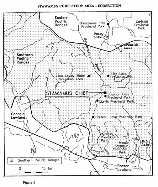
77 14
78 PAS Goal 2: TO PROTECT THE SPECIAL NATURAL, CULTURAL HERITAGE AND RECREATIONAL FEATURES OF THE PROVINCE. The Stawamus Chief and surrounding granite monoliths were identified as outstanding provincially significant examples of igneous rock in BC Parks Plan 90 Special Features for BC Parks report. The Chief is one of the world s largest freestanding granite monoliths and provides excellent rock climbing, hiking and viewing opportunities. Another significant special and/or recreation feature found partially within the Stawamus Chief study area and Shannon Falls Provincial Park is Shannon Falls. This spectacular cascading falls, the third highest in BC, is accessed from a well-developed day use area and is also connected by trail to the Chief. The Stawamus Chief study area is important to the people of the Squamish Nation. In the event of park designation for the study area, the Squamish Nation wishes to emphasize the cultural significance of the area. Rarity, Scarcity and Uniqueness: The Stawamus Chief study area contains numerous sheer granite wall faces that provide excellent rock climbing opportunities. This area has over 230 different climbing routes offering international rock climbing opportunities with a wide assortment of skill levels and degrees of difficulty. The unique combination of variety, accessibility and high suitability of the granite walls for climbing make this Canada s premier rock climbing area. The Stawamus Chief which is 700 metres high, is said to be one of the world s largest freestanding granite monoliths.* Viability: The Crown has title to approximately 497 ha or two-thirds of land within the study area including the top of the Chief. Shannon Falls Provincial Park is also located adjacent to the southern portion of the study area. The existing private lands are subject to zoning bylaws developed by the District Municipality of Squamish as part of their Official Community Plan. Three utility corridors (MOTH, Forest Service and BC Hydro) as well as two mineral claims are also found in the study area. The private lands contained within the study area are key parcels that currently provide unauthorized trailhead parking and camping. The present landowners have been contacted and are aware of the recreational values associated with the Chief. * A monolith is a distinctive, outstanding, vertical block of stone that is physically and structurally separate from other structures, such as other mountains.
79 16 The Stawamus Chief study area, located immediately to the south of the town of Squamish, is surrounded by developed industrial, commercial and residential lands and lacks the natural feeling and character of other protected areas. Diversity: The study area provides a diversity of both natural values and recreation opportunities. The Stawamus Chief study area covers portions of three watersheds including the Stawamus River, Olesen Creek and Shannon Creek. A large glacier, flowing down the Stawamus River Valley, gouged out the face of the Chief and a small, alpine glacier on its south side created the hanging valley now occupied by Olesen Creek. The striking rocky landscape, particularly the unvegetated vertical faces and nearly horizontal benchlands and summits, have resulted from geologic uplift and severe glaciation. Vegetation representative of the CWHdm ecosection provide home to a wildlife population common to British Colulmbia s southern coast. Containing some of the largest freestanding granite monoliths, this area offers spectacular viewpoints, excellent hikes and superb rock climbing opportunities. The Chief attracts approximately 500 visitors per day on summer weekends and the 1992 user survey estimates that the annual days spent on the Stawamus Chief may be as high as 50,000 for hikers and 25,000 for rock climbers. Vulnerability: The Stawamus Chief study area is under a great deal of pressure from both recreationists and developers. Access to the Chief is mainly through private lands. On these private lands are located trailhead parking and information signs, trails and informal campsites. The recreational and natural values associated with these key private land parcels are subject only to District of Squamish zoning bylaws. The lack of recreational management over this area has led to poor sanitary conditions, garbage, uncontrolled camping and worn hiking trails. The Federation of Mountain Clubs and Squamish Rock climbers along with other groups are concerned that there is no management of this special feature and it is in jeopardy from future resource or commercial development. Cultural Heritage Significance: The Stawamus Chief study area has been identified by the Squamish Nation as having significant historical and cultural values to its people. It is told by elders of the Squamish Nation that their people used this area for burial ceremonies and to seek spiritual renewal.
80 17 The Squamish Nation has a land claim against much of the area surrounding Squamish of which the Stawamus Chief study area is included. Any proposed land transfer or park establishment would not prejudice the Squamish Nation s land claim. Opportunity for Public Use and Appreciation: The opportunity for public use, recreation and outdoor appreciation is very high. In 1992 over 160,000 people visited the Chieftain viewpoint which is located at the base of the Stawamus Chief while over 360,000 visited neighbouring Shannon Falls Provincial Park. The increased popularity of the Squamish-Whistler corridor as a major destination area for outdoor recreation activities along with the rapid growth of greater Vancouver is placing more pressure on existing parks and special natural features such as the Chief. There is a growing demand for more specialized outdoor sports activities. The increased popularity in rock climbing (ie. development of new indoor rock climbing gyms) coupled with the fact that the Stawamus Chief is known as Canada s premier rock climbing area has placed greater demands on managing and developing this area. Should the study area be designated as park land and developed, an interpretation centre, dealing with the culture and the history of the Squamish Nation would provide a significant opportunity for public appreciation of Squamish culture. Opportunity for Scientific Research The unique geological formations and cultural history of the area provide opportunity for further study. However, due to the study area s small size, modified landscape and urban location, other research opportunities are limited. Ability to Address Public Perceptions and Demands The Stawamus Chief study area is located immediately south of the town of Squamish and is less than an hour s drive from Vancouver. The main parking lot, information kiosk and trailhead are adjacent to Highway 99. This is a popular destination area for rock climbers and hikers. The Chief parking lot is also popular with tourists who enjoy watching rock climbers or taking pictures of the massive granite face while travelling the Sea to Sky highway. This major highway corridor is receiving greater use and demands for special feature/recreation as the Squamish-Whistler area develops. As a result, the protection and enhancement of special recreation features like the Stawamus Chief area are paramount to ensure public access and enjoyment. From the public meetings held in August and September the majority of the responses indicated that the public supported park designation for the Stawamus Chief study area.
81 18 Though there were some concerns over management issues, respondents felt that park status was the preferred option. This support for park protection of a unique and special feature was shared by outdoor recreationists, rock climbers and residents from Squamish and Vancouver.
82 19 4. RECOMMENDATIONS 4. 1 Options Considered After reviewing the key issues, the Stawamus Chief study team proposed three options which were presented to the public in the fall of 1993 for consideration: Option A - S TATUS QUO Under this option, the present study area would be managed in a similar manner as currently exists. Existing tenures and the jurisdictions of those ministries involved in the study area, including various Ministry Acts, would continue to apply. The Official Community Plan for the District of Squamish designates the Stawamus Chief area for recreation/open space use. The recreation and open space designation is used in order to protect and preserve the recreational potential and to stress the importance of the Stawamus Chief to residents and tourists alike. The Official Community Plan provides guidelines and the intent for development and was formulated by a series of public hearings, other government agencies input and the direction of Council. An amendment to the Official Community Plan can be undertaken by Council Initiative or by application of a proponent. The Official Community Plan amendment process involves a public meeting, as outlined under the Municipal Act, with Council having the authority to adopt or reject the proposed amendment. The District of Squamish Zoning Bylaw zones the majority of land around the base of the Stawamus Chief for resource (RE) use. Under the Resource Zone, a number of uses are currently permitted within the Stawamus Chief Study Area including but not limited to extractive industries, small scale manufacturing activities, silviculture, forestry and logging, parks and playgrounds, and dog kennels. The Zoning Bylaw is the planning tool which implements the Official Community Plan. The Zoning Bylaw contains specific provisions with regards to use, setbacks, heights of buildings, densities and so on. The Zoning Bylaw can be amended, as outlined under the Municipal Act, yet all zoning bylaw amendments must be consistent with the Official Community Plan. The portion of the study area outside the District of Squamish s municipal boundary is within the Squamish-Lillooet Regional District (SLRD). The SLRD is in the process of preparing an Official Community Plan (OCP) for the Whistler-South Area, which includes the Stawamus Chief study area. To date, the SLRD has no zoning or OCP designations in the Stawamus Chief study area. The District of Squamish and SLRD planning tools are limited in scope and subject to change upon receipt of a development application and/or on the initiative of the District of Squamish Council and/or SLRD Board.
83 20 Discussion: No decision as to the future of the Stawamus Chief area would be made at this time by the study committee. Current recreational activities may continue in an informal manner, subject to private property owners discretion. Resource activities including dimension stone quarry extraction and timber harvesting would continue to be managed through the appropriate agencies guidelines. Option B - DES IGNATION OF ALL OR PART AS A PROTECTED AREA UNDER THE PARK ACT This option emphasizes the protection of the resources within the study area for recreation and conservation under the management of one agency. Designation under the Park Act of the Stawamus Chief area would see the management responsibility transferred to the Parks Division of the Ministry of Environment, Lands and Parks. Determining whether the entire area would be designated as a Class A Provincial or combination of provincial park and recreation area is subject to resolving any mineral and forestry resource concerns, private land holdings issues and aboriginal land claims. Under this option, land uses normally not associated with park values, such as timber harvesting, would not be permitted; however, mineral exploration would be permitted in the recreation area in order to properly assess mineral values. Commercial recreation, facility development and hunting would be subject to a park master plan. Discussion: This option provides the highest level of designated Protected Area Status available for the study area including the Stawamus Chief and Shannon Falls. Recreation Area status allows for time limited exploration of mineral resources. It would be intended to upgrade the recreation area to Class A Park once the mineral evaluation is completed unless potential/high mineral values are found, upon where further evaluation might occur. No timber harvesting would be permitted in the provincial park or recreation area and no mining activities would be allowed within the designated Class A parkland. BC Parks would provide the opportunity for the general public, special interest groups, local community and the Squamish Nation to be directly involved in developing and assisting in implementing a Management Plan for the area. This plan would provide direction for the management of the natural resource values, recreation values including recreation development and level of commercial recreational services that will be allowed within the area. In addition, management guidelines for the protection and enhancement of cultural values, including the concept of an interpretation centre relating to Squamish Nation cultural heritage, would be contained in such a plan.
84 21 Private and District of Squamish lands within the study area would be identified for management and eventual acquisition as funding became available, following discussions and ongoing negotiations with landowners. Option C - JOINT MANAGEMENT COMMTTTEE This option would offer similar protection to Option A (Status Quo option). However, management of the area would be by a Joint Management Committee. Members of this committee should include but are not limited to: BC Parks; Ministry of Energy, Mines and Petroleum Resources; Ministry of Forests; Ministry of Transportation and Highways; Squamish Nation; District of Squamish; Squamish-Lillooet Regional District; Squamish and Howe Sound Chamber of Commerce; Federation of Mountain Clubs of BC; Rock Climbers Associations; private landowners within the study area; and interested members of the general public. The need to designate a lead agency to guide this process and obtain budget funding are crucial to the success of this option. Discussion: An objective of this option is the development of a Joint Management Plan which would focus on providing management guidelines that recognize the area s natural features and recreation values. The lands within this area would be managed under the existing jurisdictions of the appropriate agencies. Proposed actions might include: Designate existing trails under the Forest Act (either as a recreation trail or recreation site) Designate all proposed trails under the Forest Act Maintain a Ministry of Forests map reserve over the Provincial Forest areas within the study area to include all special feature areas on Crown land as UREP Reserve under Section 12 of the Land Act Assess Shannon Falls as a possible addition to Shannon Falls Provincial Park when the master plan is reviewed Establish a EMPR No Staking Mineral Reserve over critical areas within the study area Review small scale and long term timber harvesting/rock quarrying opportunities Request the District of Squamish and the Squamish-Lillooet Regional District to recognize the area in their official community plans that would complement the overall management for the area s conservation and recreation values.
85 22 This joint management committee would work together, on an as required basis, to provide recommendation and management guidelines for long term land use planning as well as addressing specific referrals within the study area. This option, while focusing on the management of both conservation and recreation values, may provide the greatest degree of flexibility in addressing potential resource developments such as mineral extraction, forest management and future recreation development. The shortfalls of this option are that no one agency is ultimately accountable for the management of the study area and the joint management committee may lack the specific authority to implement all its recommendations. Also, this option would most likely not provide the same level of incentive for anyone to take the initiative to secure access or acquisition of key private lands. (Refer to Appendix D - Matrix to Assess Options). This matrix shows the major issues, key factors and degree of protection associated with each of the options considered.
86 RECOMMENDATION The Stawamus Chief study team has recommended a variation to the proposed Option B that was presented in the background report to the public. This recommendation is presented with the intent that the long term objective would be to designate the Stawamus Chief area as a protected area. At present the most suitable classification is Class A Park designation. In making this recommendation the study team recognizes that because of the variety of land tenures and ownerships with this study area and financial implications of acquiring the private properties, it may not be achievable to acquire and designate all of the recommended areas within the boundaries of the study area. However, the study team feels that those areas achievable should be pursued. The following is a breakdown of the study area in order of priority for designation and desired acquisition (refer to Figure 6). 1. That all vacant Crown lands and Provincial Forest land within the study area be designated as Class A Park subject to the following: a) The Mamquam Forest Service road be excluded from protected area status. b) The mineral claims known as the HAB and Rock Work claims be addressed in the following manner: i. Negotiate a quit claim for those portions of the claim within the study area, or; ii. Not include these claims in the designated protected area and wait for the claims to lapse in which case it should then be designated as part of the protected area, or if the claim holder files for a mine/quarry lease, they will at that time have to show reason for holding those portions of the lease within the present study area boundary. 2. That an agreement be negotiated with the District of Squamish to have those portions of the District of Squamish Municipal lands within the study area included into the Protected Area. These lands are described as Lot 7041, portions of District Block E of Lot 912, portions of Block D of Lot 833 and portions of Lot An alternative to the District of Squamish s outright contribution of these lands to the Protected Area may be to enter into an agreement with the Provincial Government to have these lands administered under Section 6.2 of the Park Act. 3. That the private lands within the study area be given the following priority for future acquisition and addition to the Protected Area.
87 24 It is recognized that it may not be possible to acquire all of the private lands within the study area. However, it is very important to recognize that the first three parcels of private land identified on the priority list are very important to the future of addressing recreation management and protection of the main west face of the Chief. Priority List: a) Those portions of Lot 2177, Block A within the study area owned by Amon Lands Ltd. b) Those portions of Lot 4266 within the study area owned by BC Rail. c) Those portions of Lot 1520 within the study area owned by Amon Lands Ltd. d) Those portions of Block E, Lot 912 within the study area owned by Western Forest Products. e) Those portions of Lot 1520 within the study area owned by Western Forest Products. f) Those remaining portions of private land within the study area (low priority). 4. The study team recognizes that in recommending the establishment of a protected area (Class A park) for this study area, the establishment of such a park would have to be without prejudice to any aboriginal rights and title that the Squamish Nation have. 5. In recommending the designation of the study area, the study team acknowledges the cultural heritage value of the area and recommends that consideration be given to the creation, within the protected area, of an interpretation centre relating to Squamish Nation cultural heritage. 6. In recommending the designation of the study area, the study team also feels that it is appropriate to request the District of Squamish and the Squamish-Lillooet Regional District to review their Official Community Plans and reflect appropriate statements and zoning to support the long term objective of Protected Area Status for the entire study area. Recognizing that it may not be possible to acquire all of the private properties within the study area appropriate Official Community Plans can benefit the integrity of the area as they can directly influence development that is compatible with the Protected Area.
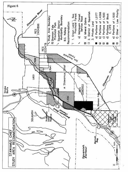
88 25
89 26 5. SOCIO-ECONOMIC VALUES Resource Values The Stawamus Chief study area lies partially within the Soo Provincial Forest and almost half of this study area has been logged. The forest values and productivity associated with the Stawamus Chief study area tend to be low on average due to environmental sensitivity, terrain and natural vegetation. Approximately 576 m3 would be contributed to the allowable annual cut of the Soo timber supply area (TSA). Using a factor of $200.00/m3, the value to the BC economy of a 576 m3/year timber harvest would be approximately $115,000 annually. This harvest would support slightly less than one direct full time job and two indirect and induced full time jobs. The mineral values associated are mainly the area s granitic rocks which display many of the characteristics of good quality dimension stone. There are two existing mineral claims in the study area. In fact, the dimension stone potential of this area has not been fully assessed and there may be potential quarry sites in the area. Recreation and Tourism Values The Stawamus Chief has been recognized as a significant special feature and major attraction to the Sea to Sky corridor (Highway 99), and is considered a very valuable visual feature to the District of Squamish. It has the reputation as a gateway to the Sea to Sky country. The Squamish area has seen an increase in population over the past years, partially as a result of the Lower Mainland s population explosion and the development and popularity increase in the resort town of Whistler. Since 1986 the annual population growth of Squamish and the Squamish-Lillooet Regional District has been 3.1% and 5.5% respectively. Associated with the study area s great visual values are the extremely high recreational values. This area is presently very popular for local residents and travellers to visit for a variety of recreational pursuits ranging from casual viewing to birdwatching, hiking, camping and rock climbing. In 1992, BC Parks recorded user statistics at the Chieftain viewpoint day use area. This location in the study area was visited by 45,490 parties (159,215 people). During the same year, BC Parks conducted user surveys at nearby Shannon Falls Provincial Park. One component of this survey determined a day use party visiting Shannon Falls expended $63.45 per day. Using this daily expenditure calculated by the number of day use parties at the Chief, this would equate to a total expenditure of 2.9 million dollars. Another study conducted by Sea to Sky Economic Development Commission and Festivals BC in 1992 indicated that rock climbers from the Pacific Northwest expend on average $46.80 (person per day) while the G.V.R.D. participants comparatively spent $27.81 per day. It should be noted that the majority of rock climbers use alternative locations in the study area to the Chieftain day use site so it this would be additional to the users already recorded at the Chieftain day use area.
90 27 There are presently two companies in Squamish with registered guiding businesses who extensively use the Chief area and at least four other commercial operators who utilize this area for commercial guiding and climbing training but who are not registered with the Chamber of Commerce. From discussions with one of the prominent operators it is estimated that six fulltime positions lasting six months and twelve part-time positions lasting six months are directly linked to the study area. If the area receives Protected Area Status, along with some basic facility development, it is fair to estimate that use levels will increase and that the potential for economic benefit to the province and local area by tourism will increase.
91 28 6. SUMMARY OF PUBLIC REVIEW Stawamus Chief study area process: Stawamus Chief Study Area (SCSA) is identified as part of the Protected Area Strategy (PAS) process. The terms of reference were drawn up in August, The study team is comprised of a number of provincial government ministries (ELP, Forests, EMPR); Municipal District of Squamish; Squamish-Lillooet Regional District; Squamish Nation; Squamish Chamber of Commerce; Federation of Mountain Clubs of B.C.; Squamish Rock Climbers Assoc. and Squamish Forest Advisory Committee. BC Parks will chair the SCSA. The study team will develop a draft Background Report, in the fall of Following review of the Background Report the study team will develop three Options for consideration by the public and various interest groups. The Background Report and Options were presented in July, 1993 to the Squamish Municipal Council, the Squamish Nation and private landowners for review and comments. Public input was gathered as follows: - Public information displays on the Stawamus Chief Study Area was located at the Chieftain kiosk (in parking lot). - Comment sheets were developed to collect and record public comment. - Public Open House meetings were scheduled in Vancouver during August to review and comment on the Background Report and Options. - Public Open House meeting was held at the Squamish Civic Centre in September to present and discuss the Stawamus Chief Background Report and gather public input. After all the comment sheets were collected, the information was summarized by the study team so that it may be considered in the final development of recommendations to be presented to RPAT in It is anticipated that RPAT will review and forward these recommendations to IAMC for approval. Summary of Public Review: Approximately 50 comment sheets (refer to Appendix C) were returned to the Garibaldi/Sunshine District Office following the Open Houses. Nearly 90% of the respondents supported Option B - Park Designation while 11% were in favour of Option C - Joint Management Committee. No respondents supported Option A - Status Quo.
92 APPENDICES
93 APPENDIX A Birds Detected in the Summer of 1991 Stawamus Survey blue grouse winter wren Townsend s warbler band-tailed pigeon American dipper MacGillivray s warbler common raven golden-crowned kinglet Wilson s warbler Vaux s swift Swainson s thrush yellow warbler hairy woodpecker varied thrush song sparrow northern flicker American robin white-crowned sparrow northern pigmy owl cedar waxwing dark-eyed junco olive-sided flycatcher solitary vireo red crossbill Stellar s jay warbling vireo pine siskin chestnut-backed chickadee orange-crowned warbler evening grosbeak black-capped chickadee yellow-rumped warbler western tanager
94 APPENDIX B STAWAMUS - CHIEF STUDY AREA TERMS OF REFERENCE August 11, 1992 PROJECT CONTACT: Drew Carmichael District Manager Garibaldi/Sunshine Coast Alice Lake Provincial Park Box 220 Brackendale, BC VON 1HO Jim Morris Regional Planner South Coast Region 1610 Mt. Seymour Road North Vancouver, BC V7G 1L3 GOAL As part of the Protected Area Strategy, the Stawamus - Chief Study Area, near Squamish, BC, will be studied to determine the area s future land designation, such as provincial park, wilderness area, ecological reserve, etc., and management of its natural features and outdoor recreation opportunities. OBJECTIVES Review with Energy, Mines and Petroleum Resources (EMPR) the status and future of existing mineral resources. Review with Lands Division private land status and tenures within Stawamus - Chief Study Area. Review and obtain input from Native groups as part of the background material and information process. Set up a steering committee comprised of EMPR, Lands, Environment, Forests, Regional District, Federation of Mountain Clubs, Squamish Rock Climbers, Community Forest Advisory Committee, Squamish Nations, Squamish Municipality and Chamber of Commerce representatives. Arrange public meetings as information gathering sessions. Following public input, steering committee will make recommendations to Regional Director s Committee prior to obtaining final approval from Assistant Deputy Minister (ADM) Committee.
95 KEY ISSUES RECREATION LAND USE: Stawamus - Chief Study Area is extremely popular and heavily used by local, regional and international visitors for a variety of recreational pursuits, (i.e.), rock climbing, hiking, photography, viewing unique natural features. NATURAL RES OURCE MANAGEMENT: Forests - determine forest values vs. recreation values within the study area EMPR - Review status of existing mineral claim holders and future mineral potential of study area Lands - Private lands within the study area need to be addressed for potential future conflict, (i.e.), access, development - Identify stakeholders as part of the study area planning process. CONS ERVATION: Stawamus - Chief area is a recognized significant natural feature which provides an opportunity to protect and present this feature along a major tourism corridor, Highway 99. This area contains significant wildlife habitat for some species of raptors, (i.e.) peregrine falcons nesting sites. Inventory of area s fauna and flora should be undertaken. ABORIGIN AL INTERES TS : Stawamus - Chief area has a long-standing history associated with Squamish Nation history. The cultural values and Native interest of this area need to be determined by the Squamish Nation with assistance from the Squamish Native Band.
96 October 5, 1993 Results from Comment Sheets: APPENDIX C NORTH VANCOUVER OPEN HOUSE - August 24, 1993 (5:OO - 9:00 p.m.) To date 18 comments sheets have been sent to Garibaldi/Sunshine District Office Q1. Does the Draft Background Report provide sufficient information on the Stawamus Chief study area? YES: 17 NO: 1 COMMENTS: Made me aware of the many issues and peoples involvement of an area I took for granted. Some info (ie. maps) inaccurate; views and options unclear. It is unclear if this is supposed to be part of the 129 areas to be protected. I hope this won t detract from protecting any rainforests elsewhere in the province. Doesn t give a good enough idea of the scope. Are we determining ownership/management/maintenance/usage or what? Q2. Have all the management issues critical to the future of the Stawamus Chief study area been identified? YES: 15 NO: 3 COMMENTS: Limitation/restriction on developments such as aerial tramways to summit. Bolts/fixed pro; new trails; camping or am I misunderstanding the process? Wildlife and green space importance ignored or not seriously considered. Assess economic value of various tourist user groups for region: rock climbers, day trippers, tourists in R.V.s and campers. Q3. The study team has proposed three options for consideration: Option A - S TATUS QUO Option B - DES IGNATION UNDER THE PARK ACT Option C - JOINT MANAGEMENT COMMITTEE Other option not presented? Option A 0 Option B 17 Option C 0 Other 1
97 COMMENTS: Best long term protection. Major concern is potential liability associated in climbing and desire to minimize regulations/restrictions. Support one group having responsibility to manage project. Want park but not over managed with limitations on access, fees and camping. Preserve the area in its natural state. Provide immediate protection of a valuable resource. Tourism which will create many jobs depends on protection of the Chief. Unique natural feature with many recreational opportunities that deserves protection. Secure area for future use. The Chief is a recreational and visual treasure and no resource exploration should be allowed in this well-used area. Only option that will prevent resource development (ie. quarries, forestry). Small area and resource development seems limited compared to benefits of protection; other options presented are only compromises. Provide protection to an area where people come to enjoy for a variety of reasons. Q4. Have you ever visited the Stawamus Chief study area? YES 18 NO 0 Total no. of visits: average number of visits was over 125 No. of visits in 1993: average number of visits in 1993 was 20 Q5. What recreation/conservation activity(s) do you participate in when visiting the Stawamus Chief study area? Hiking 18 Rock climbing 14 Viewing 11 Nature appreciation 10 Camping 9 Photography 7 Other(s) - picnics, relaxing and social activities Q6. Have you any other comments on the Stawamus Chief study area? Study appears to be well conducted with good public input; what about the Smoke Bluffs? Protect the Chief from surrounding development such as Smoke Bluffs. Chief represents unique recreational and aesthetic landmark in the province that should be promoted and enjoyed. Provide camping (bivouac area) such as in Smith Rock State Park.
98 Provide free camping with minimal facilities. No additional restrictions placed on area; all environmentally damaging activities must be stopped and the area protected. Trailhead must have sanitary facilities due to its high use; urgency to protect this spectacular area. Chief area requires better management of trails, provide toilets etc. This area must remain accessible to all types of recreational activities. Public access to the Chief area is very important.
99 October 6, 1993 Results from Comment Sheets: SQUAMISH 'OPEN HOUSE' - September 15, 1993 (5:00-9:00 p.m.) To date 26 comments sheets have been sent to Garibaldi/Sunshine District Office Q1. Does the Draft Background Report provide sufficient information on the Stawamus Chief study area? YES: 22 NO: 4 COMMENTS : Property assessment/tax figures needed to determine loss of revenue to District if study area becomes a park. Well written and objective report. Option A statement is misleading - currently zoned resource and not for recreation. Maps should include specific locations of rock features in relation to private land and various land use zones. Topographic model would be helpful for identifying ownership and tenures in study area; add names of private land owners. Support this study area project. Q2. Have all the management issues critical to the future of the Stawamus Chief study area been identified? YES: 24 NO: 2 COMMENTS : More studies on animal and plant life should be undertaken. Access is a critical management issue. Economic trade-offs related to different management options needed. Add industrial issues such as proposed port south of Stawamus area. Perhaps more research into biotic values of area (ie. rare and endangered species). No park infrastructure implemented so as to minimize effect on Parks annual budget. Q3. The study team has proposed three options for consideration: Option A - S TATUS QUO Option B - DES IGNATION UNDER THE PARK ACT Option C - JOINT MANAGEMENT COMMITTEE Other option not presented?
100 Option A 0 option B 23 Option C 3 Other 0 COMMENTS: Potential for least complicated planning and management for an exceptionally precious area; least uncertainties for all interests. Offers most protection for the area (concern over all park regulations). Preserve forest land and minimize impact upon climbing activities, retain camping and add washrooms only. As a feature of regional, provincial and national significance the Chief requires the highest level of protected status. Joint management would give the necessary control without removing the revenue from property taxes. Best use of the resource. Total protection - developing recreation but not damaging wildlife (falcons). Secure area for future use. Protect this exceptional area as mining and forestry values appear to be fairly low in comparison to recreational/tourist potential. Preserve area for reasons of history, recreation and environment. Joint management committee brings more people into the process. Chief is second largest monolith in the world and park designation is only realistic option. Q4. Have you ever visited the Stawamus Chief study area? YES 25 NO 1 Total no. of visits: average number of visits was over 200 No. of visits in 1993: average number of visits in 1993 was 35 Q5. What recreation/conservation activity(s) do you participate in when visiting the Stawamus Chief study area? Hiking 23 Rock climbing 20 Viewing 19 Nature appreciation 19 Camping 9 Photography 17 Other(s) - relaxing and education (science studies) proximity to large centre - enjoyment for thousands of users. rock climbing opportunities one of best in the world.
101 Bullethead campground and Psyche Lodge are last informal campgrounds between Squamish and Vancouver. trails need upgrading, particularily between swithbacks and 2nd Peak. easy access to a variety of recreation opportunities is great. Q6. Have you any other comments on the Stawamus Chief study area? Study area offers excellent level of recreation/conservation with opportunities to develop even further with proper management. Chief is world reknowned and Squamish would suffer financially is the area was not protected. Good job, excellent Open House discussion and thanks to Committee members. Environmentally friendly area - concern over spraying of pesticides. Provide free camping with minimal facilities. No additional restrictions placed on area; all environmentally damaging activities must be stopped and the area protected. Trailhead must have sanitary facilities due to its high use; urgency to protect this spectacular area. Chief area requires better management of trails, provide toilets etc. This area must remain accessible to all types of recreational activities. Support park designation only if followed by fiscal and budgetary responsibility and restraint. Do not understand why Smoke Bluffs was not included in the study area. Tourism and recreation provide significant financial contributions to the local Squamish economy. Will turning this area into a destination point destroy the area? Consider ways in which to compliment this natural feature by improving the viewing quality of the surrounding developed lands. Resource values are not as high or significant as recreation/conservation values. The Chief must remain a roadside bit of wilderness for the people. Park designation is only way to resolve restricted access over private land and associated liability/litigation problems. Problems associated with park designation will be only in the short term and protection for future enjoyment will far outweigh this difficult decision. By not designating the Chief as a park, BC is neglecting to protect one of its most outstanding geological features. As Squamish relies less on forestry, other economic sources such as recreation and tourism (from designating the Chief as a park) will become more important.
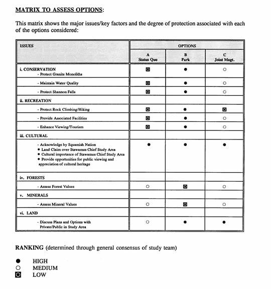
102
Yard Creek Provincial Park. Management Plan
 Yard Creek Provincial Park Management Plan Draft January 2010 Yard Creek Provincial Park Management Plan Approved by: telàlsemkin/siyam/chief Scott Benton Bill Williams Squamish Executive Director ation
MANAGEMENT DIRECTION STATEMENT
 Skeena District MAAGEMET DIRECTIO STATEMET July, 2000 for Driftwood Canyon Provincial Park Ministry of Environment Lands and Parks BC Parks Division i Table of Contents Driftwood Canyon Park Approvals
MANAGEMENT DIRECTION STATEMENT June, 1999
 Thompson River District MANAGEMENT DIRECTION STATEMENT June, 1999 for Roche Lake Provincial Park Ministry of Environment Lands and Parks BC Parks Division Table of Contents I. Introduction A. Setting
MARBLE RIVER PROVINCIAL PARK
 MARBLE RIVER PROVINCIAL PARK PURPOSE STATEMENT AND ZONING PLAN March 2003 MARBLE RIVER PROVINCIAL PARK Purpose Statement and Zoning Plan Primary Role The primary role of Marble River Park is to protect
Appendix A BC Provincial Parks System Goals
 Appendix A BC Provincial Parks System Goals The British Columbia Provincial Parks System has two mandates: To conserve significant and representative natural and cultural resources To provide a wide variety
5.0 OUTDOOR RECREATION OPPORTUNITIES AND MANAGEMENT
 5.0 OUTDOOR RECREATION OPPORTUNITIES AND MANAGEMENT 5.1 Introduction This section describes the range of recreational activities that currently take place in Marble Range and Edge Hills Parks, as well
Outdoor Recreation Opportunities Management
 Outdoor Recreation Opportunities Management Introduction A major role of a management plan is to provide direction regarding the types of recreation that are appropriate, and to outline the steps that
Pillar Park. Management Plan
 Pillar Park Management Plan January 2014 Pillar Park Management Plan Approved by: Jeff Leahy Regional Director Thompson Cariboo Region BC Parks January 9, 2014 Date Brian Bawtinheimer Executive Director
MAIN LAKE PROVINCIAL PARK
 MAIN LAKE PROVINCIAL PARK PURPOSE STATEMENT AND ZONING PLAN March 2003 MAIN LAKE PROVINCIAL PARK Purpose Statement and Zoning Plan Primary Role The primary role of Main Lake Park is to protect a biologically
Continental Divide National Scenic Trail Legislative History and Planning Guidance
 Continental Divide National Scenic Trail Legislative History and Planning Guidance Legislation, Policy, and Direction Regarding National Scenic Trails The National Trails System Act, P.L. 90-543, was passed
2.0 PARK VISION AND ROLES
 2.0 PARK VISION AND ROLES 2.1 Significance in the Protected Area System Marble Range and Edge Hills provincial parks protect 6.8% of the Pavillion Ranges Ecosection, which is located in the Southern Interior
Watchorn Provincial Park. Management Plan
 Watchorn Provincial Park Management Plan 2 Watchorn Provincial Park Table of Contents 1. Introduction... 3 2. Park History... 3 3. Park Attributes... 3 3.1 Natural... 4 3.2 Recreational... 4 3.3 Additional
PROUDLY BRINGING YOU CANADA AT ITS BEST. Management Planning Program NEWSLETTER #1 OCTOBER, 2000
 PROUDLY BRINGING YOU CANADA AT ITS BEST VUNTUT NATIONAL PARK Management Planning Program NEWSLETTER #1 OCTOBER, 2000 INTRODUCTION This newsletter launches the development of the first management plan for
Restore and implement protected status that is equivalent, or better than what was lost during the mid-1990 s
 THE ROSSLAND RANGE, OLD GLORY AREA. Executive summary. The Friends of the Rossland Range Society, on behalf of the local outdoor community, seeks to accomplish the following with respect to the Old Glory
BLANKET CREEK PROVINCIAL PARK
 BLANKET CREEK PROVINCIAL PARK PURPOSE STATEMENT AND ZONING PLAN February 2003 BLANKET CREEK PROVINCIAL PARK Purpose Statement and Zoning Plan Primary Role The primary role of Blanket Creek Park is to maintain
VARGAS ISLAND PROVINCIAL PARK
 VARGAS ISLAND PROVINCIAL PARK PURPOSE STATEMENT AND ZONING PLAN February 2003 VARGAS ISLAND PROVINCIAL PARK Purpose Statement and Zoning Plan Primary Role The primary role of Vargas Island Park is to protect
As outlined in the Tatshenshini-Alsek Park Management Agreement, park management will:
 Management Strategy General Strategy The priority management focus for the park is to ensure that its internationally significant natural, cultural heritage and recreational values are protected and that
STONE MOUNTAIN PROVINCIAL PARK Purpose Statement and Zoning Plan
 1 STONE MOUNTAIN PROVINCIAL PARK Purpose Statement and Zoning Plan Stone Mountain Provincial Park is situated 140 km west of Fort Nelson at Kilometre 595 of the Alaska Highway. The 25 690 ha park is located
MANAGEMENT DIRECTION STATEMENT March 2003
 Skeena Region MAAGEMET DIRECTIO STATEMET March 2003 for Meziadin Lake Provincial Park Ministry of Water, Land and Air Protection Environmental Stewardsh Division This page left blank on purpose ii Table
MANAGEMENT DIRECTION STATEMENT
 Lower Mainland District MAAGEMET DIRECTIO STATEMET January 2001 for Liumchen Ecological Reserve Ministry of Environment Lands and Parks BC Parks Division Table of Contents Page Introduction... 1 Purpose
Establishing a National Urban Park in the Rouge Valley
 STAFF REPORT ACTION REQUIRED Establishing a National Urban Park in the Rouge Valley Date: March 29, 2012 To: From: Wards: Reference Number: Executive Committee Deputy City Manager, Cluster B All p:\2012\cluster
ANAGEMENT P LAN. February, for Elk Lakes and Height of the Rockies Provincial Parks. Ministry of Environment, Lands and Parks BC Parks Division
 M ANAGEMENT P LAN February, 1999 for Elk Lakes and Height of the Rockies Provincial Parks Ministry of Environment, Lands and Parks BC Parks Division Elk Lakes & Height of the Rockies Provincial Parks M
Marchand Provincial Park. Management Plan
 Marchand Provincial Park Management Plan 2 Marchand Provincial Park Table of Contents 1. Introduction... 3 2. Park History... 3 3. Park Attributes... 4 3.1 Natural... 4 3.2 Recreational... 4 3.3 Additional
SANTA-BOCA PROVINCIAL PARK
 SANTA-BOCA PROVINCIAL PARK PURPOSE STATEMENT AND ZONING PLAN March 2003 SANTA-BOCA PROVINCIAL PARK Purpose Statement and Zoning Plan Primary Role The primary role of Santa-Boca Park is to provide marine-based
Mackinnon Esker Ecological Reserve Draft - Management Plan
 Mackinnon Esker Ecological Reserve Draft - Management Plan May 2011 Photo Credit: This document replaces the direction provided in the Carp Lake Provincial Park and Protected Area and Mackinnon Esker Ecological
ROBERTS CREEK PROVINCIAL PARK MASTER PLAN. November, 1981
 Ministry of Lands, Parks and Housing Parks and Outdoor Recreation Division Park Operations Branch North Vancouver, B. C. ROBERTS CREEK PROVINCIAL PARK MASTER PLAN November, 1981 Mr. G. Trachuk Director
RE: Access Fund Comments on Yosemite National Park Wilderness Stewardship Plan, Preliminary Ideas and Concepts
 September 30, 2016 Superintendent Yosemite National Park Attn: Wilderness Stewardship Plan P.O. Box 577 Yosemite, CA 95389 RE: Access Fund Comments on Yosemite National Park Wilderness Stewardship Plan,
MANAGEMENT DIRECTION STATEMENT June, 1999
 Thompson River District MANAGEMENT DIRECTION STATEMENT June, 1999 for Clearwater River Corridor (Addition to Wells Gray Park) Ministry of Environment Lands and Parks BC Parks Division ii Table of Contents
FILE: /PERM EFFECTIVE DATE: May 16, 2014 AMENDMENT:
 APPROVED AMENDMENTS: Effective Date Briefing Note /Approval Summary of Changes: FILE: 11000-00/PERM EFFECTIVE DATE: May 16, 2014 AMENDMENT: Table of Contents 1. POLICY APPLICATION... 1 2. PRINCIPLES AND
Mackinnon Esker Ecological Reserve. Management Plan
 Mackinnon Esker Ecological Reserve Management Plan March 2017 Cover Page Photo Credit: Rob Bell This document replaces the direction provided in the Carp Lake Provincial Park and Protected Area and Mackinnon
Kit Carson-Challenger Ridge Trail Project Annual Performance Report-2014 October 22, 2014
 1 Kit Carson-Challenger Ridge Trail Project Annual Performance Report-2014 October 22, 2014 Willow Lake and Kit Carson Peak 2 SUMMARY The Rocky Mountain Field Institute began Phase 1 of a multi-phase,
OMINEACA PROVINCIAL PARK
 OMINEACA PROVINCIAL PARK AND PROTECTED AREA PURPOSE STATEMENT AND ZONING PLAN March 2003 OMINECA PROVINCIAL PARK AND PROTECTED AREA Purpose Statement and Zoning Plan Omineca Park and Omineca Protected
Whitemouth Falls Provincial Park. Draft Management Plan
 Whitemouth Falls Provincial Park Draft Management Plan Whitemouth Falls Provincial Park Draft Management Plan Table of Contents 1. Introduction... 3 2. Park History... 3 3. Park Attributes... 4 3.1 Natural...
Land Management Summary
 photo credit: ANGAIR Anglesea Heath Land Management Summary The Anglesea Heath (6,501 ha) was incorporated into the Great Otway National Park in January 2018. This provides an opportunity to consider the
Preferred Recreation Recommendations Stemilt-Squilchuck Recreation Plan March 2018
 Preferred Recreation Recommendations Stemilt-Squilchuck Recreation Plan March 2018 Below are the recommended recreation ideas and strategies that package together the various recreation concepts compiled
Logo Department Name Agency Organization Organization Address Information 5700 North Sabino Canyon Road
 Logo Department Name Agency Organization Organization Address Information United States Forest Coronado National Forest 5700 North Sabino Canyon Road Department of Service Santa Catalina Ranger District
Outdoor Recreation Opportunities Management
 Outdoor Recreation Opportunities Management Introduction The natural features of Height of the Rockies and Elk Lakes provincial parks provide a wide variety of outdoor recreational activities. However,
ANAGEMENT. LAN November, 1996
 M ANAGEMENT P LAN November, 1996 for Paul Lake Provincial Park Ministry of Environment, Lands and Parks BC Parks Department Paul Lake Provincial Park M ANAGEMENT P LAN Prepared by BC Parks Kamloops Area
APPENDIX. Alberta Land Stewardship Act AMENDMENTS TO THE SOUTH SASKATCHEWAN REGIONAL PLAN
 APPENDIX Alberta Land Stewardship Act AMENDMENTS TO THE SOUTH SASKATCHEWAN REGIONAL PLAN 1 All references to Alberta Environment and Sustainable Resource Development, Environment and Sustainable Resource
Victor Lake Park. Management Plan
 Victor Lake Park Management Plan November 2012 Victor Lake Park Management Plan Approved by: Jeff Leahy, Regional Director Thompson Cariboo Region BC Parks March 28, 2012 Date Brian Bawtinheimer, Executive
SPECTACLE LAKE PROVINCIAL PARK PURPOSE STATEMENT AND ZONING PLAN
 SPECTACLE LAKE PROVINCIAL PARK PURPOSE STATEMENT AND ZONING PLAN August 2003 1 SPECTACLE LAKE PROVINCIAL PARK Purpose Statement and Zoning Plan Primary Role The primary role of Spectacle Lake Park is to
Little Limestone Lake Provincial Park. Draft Management Plan
 Little Limestone Lake Provincial Park Draft Management Plan Little Limestone Lake Provincial Park Draft Management Plan Table of Contents 1. Introduction... 3 2. Background... 3 3. Planning context...
Role of the Protected Area
 Role of the Protected Area Provincial and Regional Context Height of the Rockies and Elk Lakes provincial parks lie in southeastern British Columbia in the Rocky Mountains, about 85 km southwest of Calgary,
Pembina Valley Provincial Park. Draft Management Plan
 Pembina Valley Provincial Park Draft Management Plan 2 Pembina Valley Provincial Park Table of Contents 1. Introduction... 3 2. Park History... 3 3. Park Attributes... 3 3.1 Natural... 3 3.2 Recreational...
ANAGEMENT P LAN. July for Chilliwack Lake Park & Chilliwack River Ecological Reserve. Ministry of Environment, Lands and Parks BC Parks Division
 M ANAGEMENT P LAN July 2000 for Chilliwack Lake Park & Chilliwack River Ecological Reserve Ministry of Environment, Lands and Parks BC Parks Division Chilliwack Lake Provincial Park & Chilliwack River
Steps in the Management Planning Process
 Steps in the Management Planning Process Developing a management plan for Kalamalka Lake Park will follow a multi-stage process. The planning process for this park is currently in the Draft Management
Criddle/Vane Homestead Provincial Park. Management Plan
 Criddle/Vane Homestead Provincial Park Management Plan 2 Criddle/Vane Homestead Provincial Park Table of Contents 1. Introduction... 3 2. Park History.... 3 3. Park Attributes.... 4 3.1 Natural.... 4 3.2
D IRECTION S TATEMENT
 Vancouver Island Region M ANAGEMENT D IRECTION S TATEMENT September 2003 for Lower Nimpkish Provincial Park Ministry of Water, Land and Air Protection Environmental Stewardship Lower Nimpkish Provincial
Fred Antoine Park. Management Plan. Final Public Review Draft
 Fred Antoine Park Management Plan Final Public Review Draft March 2016 Fred Antoine Park Management Plan Approved by: Jeff Leahy Regional Director Thompson Cariboo Region BC Parks Date Brian Bawtinheimer
Conservation Area Management Statement
 Conservation Area Management Statement Miller Creek Wildlife Area Resolution #: Approval: Issue Date: Date of Last Revision: Table of Contents 1. Purpose....... 1 2. Property Description...... 1 2.1. Legal
KANANASKIS COUNTRY PROVINCIAL RECREATION AREAS MANAGEMENT PLAN DRAFT TERMS OF REFERENCE - November 20, 2007
 KANANASKIS COUNTRY PROVINCIAL RECREATION AREAS MANAGEMENT PLAN DRAFT TERMS OF REFERENCE - November 20, 2007 BACKGROUND There are 42 Provincial Recreation Areas (PRAs) within Kananaskis Country located
ANAGEMENT. LAN November, 1996
 M ANAGEMENT P LAN November, 1996 for Coldwater River Provincial Park Ministry of Environment, Lands and Parks BC Parks Department Coldwater River Provincial Park M ANAGEMENT P LAN Prepared by BC Parks
Clearwater Lake Provincial Park. Draft Management Plan
 Clearwater Lake Provincial Park Draft Management Plan Clearwater Lake Provincial Park Draft Management Plan Table of Contents 1. Introduction... 3 2. Park History... 4 3. Park Attributes... 4 3.1 Location/Access...4
BELLHOUSE PROVINCIAL PARK
 BELLHOUSE PROVINCIAL PARK PURPOSE STATEMENT AND ZONING PLAN March 2003 1 BELLHOUSE PROVINCIAL PARK Purpose Statement and Zoning Plan Primary Role The primary role of Bellhouse Provincial Park is to protect
Procedure for the Use of Power-Driven Mobility Devices on Mass Audubon Sanctuaries 1 September 17, 2012
 Procedure for the Use of Power-Driven Mobility Devices on Mass Audubon Sanctuaries 1 September 17, 2012 Background As part of Mass Audubon s mission to preserve the nature of Massachusetts for people and
Rogue River Access and Management Plan Draft Alternatives
 Rogue River Access and Management Plan Draft Alternatives The Rogue River Access and Management Plan was initiated in December, 2011 and is being led by Jackson County Parks (JCP) and Oregon Department
Wallace Lake Provincial Park. Management Plan
 Wallace Lake Provincial Park Management Plan 2 Wallace Lake Provincial Park Table of Contents 1. Introduction... 3 2. Park History... 3 3. Park Attributes... 4 3.1 Natural... 4 3.2 Recreational... 4 4.
BACKCOUNTRY TRAIL FLOOD REHABILITATION PROGRAM
 BACKCOUNTRY TRAIL FLOOD REHABILITATION PROGRAM Backcountry Trail Flood Rehabilitation A June 2013 Flood Recovery Program Summary In June 2013, parts of Southern Alberta were devastated from significant
PLUMPER COVE MARINE PARK MASTER PLAN
 Lower Mainland Region Park Operations Branch Parks and Outdoor Recreation Division Ministry of Lands, Parks and Housing North Vancouver, B.C. PLUMPER COVE MARINE PARK MASTER PLAN DECEMBER, 1980 PLUMPER
Dragon Mountain Park. Management Plan. Public Review Draft
 Disclaimer: This draft management plan contains preliminary proposals that are subject to change and therefore may not necessarily reflect the position of the Ministry of Environment. At the conclusion
EXECUTIVE SUMMARY PROGRAM DEVELOPMENT REPORT PURPOSE EXISTING SETTING EXPANDING PARKLAND
 EXECUTIVE SUMMARY PROGRAM DEVELOPMENT REPORT PURPOSE As the culmination of the first phase of the master planning process, this Program Development Report creates the framework to develop the Calero County
A GUIDE TO MANITOBA PROTECTED AREAS & LANDS PROTECTION
 A GUIDE TO MANITOBA PROTECTED AREAS & LANDS PROTECTION Manitoba Wildands December 2008 Discussions about the establishment of protected lands need to be clear about the definition of protection. We will
Connie Rudd Superintendent, Black Canyon of the Gunnison National Park
 National Park Service U.S. Department of the Interior Black Canyon of the Gunnison National Park and Curecanti National Recreation Area Information Brochure #1 Wilderness and Backcountry Management Plan
FINGER-TATUK PROVINCIAL PARK
 FINGER-TATUK PROVINCIAL PARK PURPOSE STATEMENT AND ZONING PLAN March 2003 FINGER-TATUK PROVINCIAL PARK Purpose Statement and Zoning Plan Finger-Tatuk Provincial Park is 17,151 ha in size. It includes the
DIRECTOR S ORDER #41: Wilderness Preservation and Management
 These are relevant sections about Wilderness Management Plans from National Park Service 2006 Management Policies, Director s Orders #41 and Reference Manual 41. National Park Service U.S. Department of
Sand Lakes Provincial Park. Draft Management Plan
 Sand Lakes Provincial Park Draft Management Plan 2 Sand Lakes Provincial Park Table of Contents 1. Introduction... 3 2. Background... 3 3. Park Purpose... 5 4. Park Management Guidelines... 6 Appendix...
SUGARBOWL-GRIZZLY DEN PROVINCIAL PARK AND SUGARBOWL-GRIZZLY DEN PROTECTED AREA Purpose Statement and Zoning Plan
 SUGARBOWL-GRIZZLY DEN PROVINCIAL PARK AND SUGARBOWL-GRIZZLY DEN PROTECTED AREA Purpose Statement and Zoning Plan Located one hour east of Prince George on Highway 16, Sugarbowl-Grizzly Den Provincial Park
Ouimet Canyon Provincial Nature Reserve. Management Plan
 Ouimet Canyon Provincial Nature Reserve Management Plan NOTE: This document has been scanned and formatted, and therefore is slightly different from the original version. -March 2002 Additional copies
Nakina Moraine Provincial Park. Interim Management Statement. Ontario. Ministry of Natural Resources
 Nakina Moraine Provincial Park Interim Management Statement Ontario Ministry of Natural Resources 1999, Queen's Printer for Ontario Printed in Ontario, Canada Additional copies of this publication can
CARMANAH WALBRAN PROVINCIAL PARK
 CARMANAH WALBRAN PROVINCIAL PARK PURPOSE STATEMENT AND ZONING PLAN September 2003 1 CARMANAH WALBRAN PROVINCIAL PARK Purpose Statement and Zoning Plan Carmanah Walbran Provincial Park is an expansion of
Policy PL Date Issued February 10, 2014
 Subject RENEWABLE ENERGY ON CROWN LAND Compiled by Renewable Energy Program, Biodiversity Branch Replaces Policy Directives Waterpower Site Release Crown Land Onshore Windpower Development - Crown Land
Policy. Huts, Cabins and Lodges in BC Provincial Parks
 Policy Huts, Cabins and Lodges in BC Provincial Parks Federation of Mountain Clubs of BC Version 1.3 Published August 2, 2015 INTRODUCTION The Federation of Mountain Clubs of BC (FMCBC) promotes self-propelled
Port Bruce. Interim Management Statement
 Port Bruce Interim Management Statement Port Bruce Interim Management Statement August 3, 1999 This Port Bruce Provincial Park Interim Management Statement provides direction for the custodial management
Parkland County Municipal Development Plan Amendment Acheson Industrial Area Structure Plan
 Parkland County Municipal Development Plan Amendment Acheson Industrial Area Structure Plan New Plan Acheson Industrial Area Structure Plan Amendment Parkland County Municipal Development Plan Board Reference
Natural and Cultural Values and Their Management...18
 Skagit Valley Provincial Park Management Plan Table of Contents Plan Highlights...4 Introduction...5 The Management Planning Process...5 Background Summary...6 Relationship to Other Land Use Planning...8
Non-motorized Trail Plan & Proposal. August 8, 2014
 Town of Star Valley Ranch, Wyoming and the Star Valley Ranch Association in partnership with the USDA Forest Service, Bridger-Teton National Forest, Greys River Ranger District Non-motorized Trail Plan
Theme: Predominately natural/natural appearing; rustic improvements to protect resources. Size*: 2,500 + acres Infrastructure**:
 Recreation Opportunity Spectrum (ROS) Classes The Recreation Opportunity Spectrum (ROS) provides a way to describe the variations in the degree of isolation from the sounds and influences of people, and
MANAGEMENT DIRECTION STATEMENT March 2003
 Skeena Region MAAGEMET DIRECTIO STATEMET March 2003 for Great Glacier Provincial Park Ministry of Water, Land an Air Protection Environmental Stewardship Division ii This management direction statement
The Vision for the San Juan Islands Scenic Byway
 The Vision for the San Juan Islands Scenic Byway 2 Judd Cove, Orcas Island, Courtesy of Kurt Thorson (kurtthorson.com) and San Juan County Land Bank Vision for the San Juan Islands Scenic Byway The San
Kit Carson-Challenger Ridge Trail Project
 Kit Carson-Challenger Ridge Trail Project Project Accomplishments Report-USFS December 15, 2015 Photo courtesy of Justin Peterson 815 South 25 th Street, Suite 101 Colorado Springs, CO 80904 Dedicated
Creating a User-Driven Long-Distance OHV Trail Through Partnering
 Joseph Raffaele Outdoor Recreation Planner U.S. Bureau of Land Management Yuma, Arizona Creating a User-Driven Long-Distance OHV Trail Through Partnering BLM is a multiple-use land management agency within
National Wilderness Steering Committee
 National Wilderness Steering Committee Guidance White Paper Number 1 Issue: Cultural Resources and Wilderness Date: November 30, 2002 Introduction to the Issue Two of the purposes of the National Wilderness
FINAL TESTIMONY 1 COMMITTEE ON RESOURCES UNITED STATES HOUSE OF REPRESENTATIVES. July 13, 2005 CONCERNING. Motorized Recreational Use of Federal Lands
 FINAL TESTIMONY 1 STATEMENT OF DALE BOSWORTH CHIEF Of the FOREST SERVICE UNITED STATES DEPARTMENT OF AGRICULTURE Before the SUBCOMMITTEE ON FORESTS AND FOREST HEALTH And the SUBCOMMITTEE ON NATIONAL PARKS,
Sasagiu Rapids Provincial Park. Draft Management Plan
 Sasagiu Rapids Provincial Park Draft Management Plan 2 Sasagiu Rapids Provincial Park Table of Contents 1. Introduction... 3 2. Background and Park Attributes... 3 2.1 Park History.... 3 2.2 Natural Features...
Beaver Creek Provincial Park. Management Plan
 Beaver Creek Provincial Park Management Plan 2 Beaver Creek Provincial Park Table of Contents 1. Introduction... 3 2. Park History... 3 3. Park Attributes... 4 3.1 Natural... 4 3.2 Recreational... 4 4.
NECHAKO CANYON PROTECTED AREA
 NECHAKO CANYON PROTECTED AREA PURPOSE STATEMENT AND ZONING PLAN March 2003 1 Nechako Canyon Protected Area Purpose Statement and Zoning Plan The Nechako Canyon Protected Area (1,246 hectares) is located
Bayview Escarpment. Interim Management Statement
 Bayview Escarpment Interim Management Statement Bayview Escarpment Provincial Nature Reserve Interim Management Statement January 15, 1995 REGIONAL DIRECTOR'S APPROVAL STATEMENT This Interim Management
Criddle/Vane Homestead Provincial Park. Draft Management Plan
 Criddle/Vane Homestead Provincial Park Draft Management Plan 2 Criddle/Vane Homestead Provincial Park Table of Contents 1. Introduction... 3 2. Park History.... 3 3. Park Attributes.... 3 3.1 Natural....
Proposal to Redevelop Lower Kananaskis River-Barrier Lake. Bow Valley Provincial Park. Frequently Asked Questions
 Proposal to Redevelop Lower Kananaskis River-Barrier Lake Bow Valley Provincial Park Frequently Asked Questions What is being proposed? What are the details of the proposal? Where is the project area located?
Proposed Scotchman Peaks Wilderness Act 2016 (S.3531)
") 1 Proposed Scotchman Peaks Wilderness Act 2016 (S.3531) Frequently Asked Questions PLACE Where is the area that would be designated as Wilderness? The lands outlined in S.3531 lie within Idaho along its
1 Proposed Scotchman Peaks Wilderness Act 2016 (S.3531) Frequently Asked Questions PLACE Where is the area that would be designated as Wilderness? The lands outlined in S.3531 lie within Idaho along its
ADDENDA. 1. It does not conform to the Master Plan format in the following areas: Statement of Purpose - clarification of parks purpose in system.
 File: 2-7-2-79-27 ADDENDA Plan for Saltery Bay Park This plan has been reviewed and is approved with the following comments and conditions: 1. It does not conform to the Master Plan format in the following
MANAGEMENT DIRECTION STATEMENT June, 1999
 Garibaldi/Sunshine Coast District MAAGEMET DIRECTIO STATEMET June, 1999 for Homathko Estuary Provincial Park Ministry of Environment Lands and Parks BC Parks Division TABLE OF COTETS Introduction...1
Coastal Gas Link Project of Trans Canada Pipelines. Community Profile of Stellat en First Nation
 Coastal Gas Link Project of Trans Canada Pipelines Community Profile of Stellat en First Nation What is the Coastal Gas Link Project? Trans Canada Pipeline is planning to build a 650 Km. natural gas pipeline
Birch Point Provincial Park. Management Plan
 Birch Point Provincial Park Management Plan 2 Birch Point Provincial Park Table of Contents 1. Introduction... 3 2. Park History... 3 3. Park Attributes... 4 3.1 Natural... 4 3.2 Recreational... 4 4. Park
Greening Project Status Report: Grand Canyon National Park
 Greening Project Status Report: Grand Canyon National Park Prepared for the Federal Energy Management Program U.S. Department of Energy February 2001 iii Contents Page 1. Introduction... 1 2. Context of
Williamson Rock/Pacific Crest National Scenic Trail (PCT) Project EIS. Notice of intent to prepare an Environmental Impact Statement.
 Project EIS. Notice of intent to prepare an Environmental Impact Statement.") [3411-15-P] DEPARTMENT OF AGRICULTURE Forest Service Angeles National Forest; Los Angeles County, CA Williamson Rock/Pacific Crest National Scenic Trail (PCT) Project EIS AGENCY: ACTION: Forest Service,
[3411-15-P] DEPARTMENT OF AGRICULTURE Forest Service Angeles National Forest; Los Angeles County, CA Williamson Rock/Pacific Crest National Scenic Trail (PCT) Project EIS AGENCY: ACTION: Forest Service,
BURGES JAMES GADSDEN PROVINCIAL PARK PURPOSE STATEMENT AND ZONING PLAN
 BURGES JAMES GADSDEN PROVINCIAL PARK PURPOSE STATEMENT AND ZONING PLAN February 2003 BURGES JAMES GADSDEN PROVINCIAL PARK Purpose Statement and Zoning Plan Primary Role The primary role of Burges James
Wallace Lake Provincial Park. Draft Management Plan
 Wallace Lake Provincial Park Draft Management Plan Wallace Lake Provincial Park Draft Management Plan Table of Contents 1. Introduction... 3 2. Park History... 3 3. Park Attributes... 4 3.1 Natural...
Stuart River Provincial Park Purpose Statement and Zoning Plan
 Stuart River Provincial Park Purpose Statement and Zoning Plan Stuart River Provincial Park protects three-quarters of the 110 kilometer long Stuart River corridor between Stuart Lake and the Nechako River.
Planning Future Directions. For BC Parks: BC Residents' Views
 Planning Future Directions For BC Parks: BC Residents' Views Summary Report Ministry of Water, Land and Air Protection Province of British Columbia April, 2002 National Library of Canada Cataloguing in