Natural and Cultural Values and Their Management...18
|
|
|
- Arthur York
- 5 years ago
- Views:
Transcription
1
2
3
4
5 Skagit Valley Provincial Park Management Plan Table of Contents Plan Highlights...4 Introduction...5 The Management Planning Process...5 Background Summary...6 Relationship to Other Land Use Planning...8 Planning Issues...9 The Role of the Park...10 International, Provincial, and Regional context...10 Significance in the Protected Area System...10 Park Roles...12 Conservation...12 Tourism and Outdoor Recreation...13 Cultural...14 Vision Statement...14 Relationship with First Nations...14 Protected Area Zoning...15 Introduction...15 Zones...15 Natural and Cultural Values and Their Management...18 Introduction...18 Land and Resource Tenures...18 Water...18 Vegetation...18 Wildlife...20 Aquatic...21 Cultural...21 Visual...22 Research I
6 Outdoor Recreation Opportunities Management...24 Introduction...24 Access Strategy...24 Management Services...24 Outdoor Recreation Opportunities Hiking and Backpacking Hunting and Fishing Auto-Access Sightseeing and Destination Camping Horseback Riding Mountain Biking Winter Recreation Walking Trails Motor Boating and Canoeing Outdoor Education...31 Communications...33 Introduction...33 Marketing and Promotion...34 Awareness and Pre-Trip Planning...34 Orientation Information...35 Natural and Cultural Heritage Education...35 Plan Implementation...36 High Priority Actions...36 Task Actions...36 Monitoring Actions
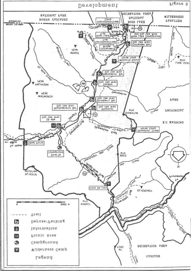
7 Figures Figure 1: Skagit Valley Park...7 Figure 2: Regional Map...11 Figure 3: Zoning...16 Figure 4: Private Lands and Mineral Claims...19 Figure 5: Development...26 Figure 6: Ross Lake/Hozameen Concept Plan...29 Appendices Appendix A: Protected Area System s Goals...38 Appendix B: BC Parks Management Planning Policy...39 Appendix C: Public Comments
8 Plan Highlights Recognizes the integral role of the Skagit Valley Provincial Park as a component of an internationally significant group of protected areas within the United States and Canada and recommends cooperation with federal, state and provincial jurisdictions. Establishes that the purpose of the park, in contrast to the more developed Chilliwack Lake, Cultus Lake and E.C. Manning Provincial Parks, is to maintain the primitive atmosphere that the park currently possesses and presents, including its use as a gateway to North Cascades National Park and the Ross Lake National Recreation Area in the United States. Requests the Ministry of Transportation and Highways to maintain the Silver-Skagit Road in its present gravel condition with improvements limited to safety. Restricts park facility development along the Skagit River to maintain a special feature river experience recognizing the river's provincial heritage status. In cooperation with the United States National Park Service, proposes to develop visitor services at Ross Lake including an international visitor center along with sani-station, power, water and sewer facilities. Addresses the need to establish a stabilized water level for Ross Lake during the summer months with the United States National Park Service and Seattle City Light. Provides park and natural history interpretive programs working closely with First Nations and local interest groups and the United States National Park Service staff. Proposes to acquire the private land and mineral claims in the provincial park when they become available. Establishes the need to review existing ecological reserves to ensure adequate representation and propose additional ecological reserves if appropriate. Encourages horse use in the Skagit Valley by providing staging areas, horse trails and wilderness horse camps linking surrounding parks. Recommends the preparation of resource plans for vegetation management, fire management, fish management, wildlife management and wildlife viewing in association with proposals for E.C. Manning Provincial Park, North Cascades National Park and Ross Lake National Recreation Area. 4
9 Introduction The Management Planning Process A management plan is an administrative manual which guides a park s management for a five to ten year term. It sets out objectives and actions for conservation, development, interpretation and operation of a park. The plan relies on current information relating to park resources, recreation uses and activities occurring on surrounding lands. This information is available from park managers, discussions with other government agencies, previously prepared reports, public interest groups, and from the general public. The process for preparing a plan involves a rigorous analysis of the overall goals of the park, patterns of use, management objectives and possible sources of conflict among park policies. Management plans establish long-term management direction for a park. They may also deal with immediate issues. As such, a plan will generally contain numerous statements describing management actions that need various degrees of attention. Since BC Parks cannot carry out every task at the same time, the plan must also set priorities for management actions. Approval of the plan is not an indication that funding to implement management actions is available. Standard funding procedures will apply during implementation of the plan. BC Parks prepares plans with a high degree of public involvement. The general public and interest groups have opportunities to provide comments to BC Parks through a variety of means including public meetings, questionnaires and local study teams. This management plan is presented in seven main sections: 1) purpose or context of the plan, highlighting planning issues and providing a summary of background information on the park; 2) role of the park and its vision statement; describing the importance of the park and critical goals and principles that establish a long-term foundation for managing the park; 3) park zoning; defining how different areas of the park will be managed; 4) resource management; objectives and associated actions for managing the park s natural and cultural resources; 5) visitor services management; objectives and actions for providing and managing outdoor recreation opportunities; 6) communications; describing how information is provided in and about the park; 7) priorities for implementing the management directives in the plan. 5 I
10 Background Summary Skagit Valley Provincial Park (Figure 1), located within the Cascade Mountains, offers a unique and diverse environment within the Lower Mainland area of British Columbia. A wide, flat valley bottom, the Skagit River, a semi-interior climate and a portion of a major reservoir have combined to create a variety of recreational opportunities unmatched by any similar sized area that is close to over half the population of British Columbia. The park was originally established in 1970 as a small 1500 hectare provincial park. In 1973, 32,000 hectares were added to the park but due to existing tenures and encumbrances it was necessary to establish the new and existing areas as the Skagit Valley Recreation Area. In 1996, the majority of the Skagit Valley Recreation Area, some 28,000 hectares, was declared Class A Park as part of a land use decision. The Park, situated on the western boundary of E.C. Manning Provincial Park, provides an easily accessible, primitive natural setting for recreationists. River and lake fishing, hunting, hiking and camping have long been the favorite activities associated with the Skagit Valley. The Skagit Valley has a colorful past and a long history of association with outdoor clubs, who were the impetus behind the protection of the area and preventing part of the Skagit Valley from being flooded as a result of proposed construction of High Ross Dam by Seattle City Light. A more detailed history of the Skagit Valley can be found in the Background Report. However, some of the highlights include: B.C. s Skagit Valley Land Act was passed authorizing the flooding to 526 m a.s.l. by Seattle City Light; Agreement between Seattle and Province of B.C. to flood the Skagit Valley to the 526 m contour level for a period of 99 years; Skagit River Class A Provincial Park established containing 1497 hectares; Two Ecological Re serves (#21 Coastal Douglas fir forest and #22 Ponderosa Pine forest) are established; Canada opposes flooding of Skagit Valley and International Joint Commission hearings are conducted; Federal and provincial governments state opposition to flooding of Skagit Valley; Skagit River Park is canceled and Skagit Valley Recreation Area established containing over 32,000 hectares; park facility development initiated with construction of Silver Tip campground; Ecological Reserve #39 (Black Cottonwoods) is established; 6
11 I
12 Ecological Reserve #106 (Red Rhododendron) is established; B.C./Seattle Agreement replaces 1967 Agreement. This Canada - U.S. Treaty on Skagit River and Ross Lake stipulates that Seattle City Light would not raise Ross Dam for 80 years in exchange for power purchased at rates equivalent to what would have resulted from raising the dam; Skagit Environmental Endowment Commission and Skagit Environmental Endowment Fund are formed to protect environmental resources and to enhance recreational opportunities; Establishment of 27, 948 hectares of the cancelled recreation area as a Class A Provincial Park. Relationship to Other Land Use Planning Management plans provide a forum for endorsement and public review of park management strategies. In this respect, a plan must be considered in terms of its relationship with broader conservation and recreation goals for the province and with other land use strategies. Initiated in 1989, this plan was prepared by BC Parks staff and tabled in draft form. The draft was then reviewed in open houses and public meetings in Princeton, Hope, Chilliwack, Vancouver and Seattle. Comments on the draft were reviewed by BC Parks staff, considered and incorporated if appropriate. The draft plan was tabled until a key land use component could be finalized by government. In 1996, some 3500 hectares of land at Silverdaisy and 26 Mile Creeks were removed from Park Act status to allow for mineral exploration and potential development purposes. With the 1996 land use decision confirming the park boundaries, the plan is now finalized and stands as a complementary document to the 1990 plan for North Cascades National Park and Ross Lake National Recreation Area and the draft plan for E.C. Manning Park and the Cascade Recreation Area. In reviewing and updating the Skagit Valley Provincial Park Management Plan, BC Parks has received and will continue to receive input from a number of agencies in addition to the general public. Agency input has been received from managers of contiguous areas including E.C. Manning Park, Cascade Recreation Area and from North Cascades National Park and Ross Lake National Recreation Area. Input has also been received from the provincial Ministries of Forests, Transportation and Highways, and Environment, Lands and Parks and the nearby municipalities of Chilliwack, Hope and Princeton as well as Seattle and Vancouver. BC Parks has received comments from wildlife groups, sport, recreation and conservation associations and the general public from these communities and throughout the province. 8
13 Planning Issues The management plan addresses a number of key planning issues raised by the public and identified by BC Parks. These include: 1) Role of the Park The Skagit Valley offers a very different conservation and recreation role than the adjacent E.C. Manning Provincial Park and Chilliwack Lake Provincial Park as well as North Cascades National Park and Ross Lake National Recreation Area. This variety is important to the existing users and the provincial park system as a whole. 2) Park Access Many people recognize the significance that the gravel access road has on maintaining the existing atmosphere and experience in the Skagit Valley and the northern part of Ross Lake National Recreation Area. 3) Relationship to North Cascades National Park The Skagit Valley provides a major access route to North Cascades National Park and Ross Lake National Recreation Area. Park development must be coordinated and because resource management plans must be complementary, both initiatives will involve significant liaison with the United States National Park Service. 4) Relationship to E.C. Manning Park, Cascades Recreation Area and the four provincial ecological reserves within the park boundary. Four ecological reserves are within the boundary of the park. These reserves, totalling some 300 hectares, were established prior to the establishment of the park and were intended to protect an example of a black cottonwood stand, a Coastal Douglas fir stand, red rhododendron habitat and ponderosa pine habitat. Management plans for these reserves will be prepared separately. As with the United States National Park Service s land to the south, park developments and management plans must complement other BC Parks objectives for adjacent provincial park and ecological reserve lands. 5) Relationship with the Skagit Environmental Endowment Commission (SEEC). In 1984, SEEC was formed as part of the agreement not to flood the Skagit Valley. The Commission oversees $5 million U.S. funds used to conserve the natural and cultural resources of the Skagit River watershed above Ross Dam in the United States (this includes the entire watershed of the Skagit River in Canada) and provide recreation opportunities. Approximately $400,000 U.S. is expended each year on both sides of the International Boundary. Continued liaison and a close working relationship with the Commission is essential. 9 I
14 Role Of The Park International, Provincial, and Regional Context The park is at the northern end of a large 1.2 million hectare national park and national recreation area system in the North Cascades mountains of Washington State (Figure 2). In addition to acting as a conservation buffer to this system, the park acts as a northern gateway providing road access to the head of Ross Lake for fishing and camping and the trailheads of the backcountry of North Cascade National Park. The park, lying between the main ranges of the Coast Mountains, 32 kilometers southeast of Hope, is accessed via the Silver Skagit Road off Highway #1. Approximately two hours from the Greater Vancouver area, the Skagit Valley offers excellent outdoor recreation opportunities in a natural, wilderness-like setting. Climate and location combine to create an ecological transition zone between coastal and interior forest types, resulting in a rich diversity of plant species and wildlife. There are a number of provincial recreation destinations in this region including E.C. Manning, Chilliwack Lake, Sasquatch, Silver Lake and Cultus Lake Provincial Parks. Many private sector R.V. parks, motels/resorts and theme parks are located in the Chilliwack-Hope area to attract the travelling public. Additionally, local and regional parks and Forest Service recreation sites provide a variety of recreational opportunities for residents and visitors in this area. Significance in the Protected Areas System Skagit Valley Park is significant in British Columbia s Protected Areas System for several reasons: 1) five of British Columbia s 14 biogeoclimatic zones are represented in this relatively small 28,000 hectare park. This compares with Tweedsmiuir Park which contains eight biogeoclimatic zones but is 35 times larger. 2) Skagit Valley Park is one of four areas where provincial protected areas are part of an international biological, cultural heritage and outdoor recreation protection grouping. These groupings include a) Peace Arch Park (joint BC Parks and Washington State Parks and Recreation Commission management); b) Skagit Valley/E.C. Manning/Cascade Recreation Area (BC) - Cascades National Park (USA) - Ross Lake National Recreation Area (USA); c) Tatshenshini Alsek Wilderness Park (BC) - Kluane National Park (Canada) - Glacier Bay National Park (USA); and, d) Akamina- Kishenina Park (BC) - Waterton National Park (Canada) - Glacier National Park (USA). 3) The Skagit River is one of the most scenic rivers and presents among the best fly-fishing opportunities in the Protected Areas System. 4) Skagit River Park protects special features including rare plant habitat (red rhododendron) and endangered wildlife species (Spotted Owl). 10
15 I

16 Park Roles Conservation In keeping with the goals of the BC Protected Areas System (Appendix A), the primary conservation roles for the park are: to represent the Eastern Pacific Ranges Ecosection within the Pacific Ranges Ecoprovince. to preserve and present the ecosection s special natural, cultural heritage and recreational features. From the rugged mountain peaks surrounding the Skagit Valley to the wide valley floor with the Skagit River flowing into Ross Lake, it is important to preserve the provincially significant features in their natural state for the inspirational use and enjoyment of all visitors. Skagit Valley (looking north) 12

17 Tourism and Outdoor Recreation Climate, geography and ecological diversity combine in the Skagit Valley to offer a remarkable variety of recreational opportunities. It is undoubtedly one of the best areas of its size to offer such a variety of recreational opportunities within close proximity to over half the population of British Columbia. Skagit Valley Provincial Park serves two of the four recreation goals including: to provide a quality backcountry destination area in a natural environment The park has the potential to offer one of the widest range of backcountry opportunities within the Lower Mainland. These opportunities include: quality lake and river fishing wilderness camping, hiking and horseback riding access to E.C. Manning Provincial Park, Cascade Recreation Area, North Cascades National Park and Ross Lake National Recreation Area; and, to provide a variety of river and valley-related camping and outdoor experiences to serve the needs for regional recreation These local/regional outdoor recreation opportunities include: lake and river-oriented, easy access camping hunting nature study riding and hiking in the valley and along historic trails Recreational Canoeing in the Skagit River 13
18 Cultural The cultural values of the Skagit Valley begin with the use of the Valley by both the Sto:lo and Nlaka pamux First Nations and continue with its designation as a provincial park and part of a large international protected area complex in the Cascade Mountains. The Valley saw trail development to the Cariboo for the goldseekers, construction of mining towns based on salting the mineral showings and attempts to farm the rocky soil. It also was the center of a major land use decision in the 1970s; the reversal of a government decision to flood the Valley. The current outcome of this decision is park designation. As such, the cultural role for the park is to preserve and present this wide variety of cultural values. Vision Statement As part of an overall international park initiative in the Cascade Mountains, Skagit Valley Provincial Park will preserve and present the natural, scenic and historic features of the area as well as provide recreation opportunities that complement those opportunities, existing and planned, provided by North Cascades National Park, Ross Lake National Recreation Area in the United States of America and E.C. Manning Provincial Park and the Cascades Recreation Area in Canada. Park management will focus on cooperation between BC Parks and the United States National Park Service as well as First Nations, other agencies, non-government organizations and the public in an attempt to showcase the long history and significance of the park. Relationship with First Nations Skagit Valley Provincial Park is part of the territory of the Sto:lo and the Nlaka pamux First Nations. Currently little is known about the First Nations use of the area and their relationship with the Upper Skagit tribes in the United States. To ensure that aboriginal rights are not justifiably infringed, one of the plan s major objectives will be to determine the extent of their traditional uses. 14
19 Protected Area Zoning Introduction Provincial parks established for more than one purpose are required by the Park Act to be directed by a zoning plan. Zoning is a planning procedure used to organize a park into comprehensive land and water units or zones based upon uniform and consistent management objectives. Since they reflect the intended land use, level of management and development for each zone, they also determine the levels of human activity to be accommodated (Appendix B). Zones Skagit Valley Provincial Park is divided into four of the possible five zones: Intensive Recreation Zone, Natural Environment Zone, Wilderness Recreation Zone and Special Features Zone (Figure 3). Zoning on the easterly and southerly boundary complements zoning in E.C. Manning Park, the Ross Lake National Recreation Area and North Cascades National Park. Intensive Recreation Zone The objective of this zone is to provide a variety of auto accessible, facility oriented outdoor recreation opportunities. Approximately 900 hectares of the park s 28,000 hectares or about 3%, fall into this zone which includes the Silver-Skagit Road and two main activity areas at Ross Lake and Silver Tip campground. Natural Environment Zone The objective of this zone is to provide for non vehicular recreation opportunities in a largely undisturbed natural environment. Though characterized by low-to-moderate use, this zone precludes any sense of wilderness isolation. Facilities, include trails and walkin campsites. The main portion of the Skagit Valley, exclusive of the riverine environment of the Skagit River, containing some 9,000 hectares, or 32%, fall into this zone. Wilderness Recreation Zone The objective of the 15,000 hectare wilderness recreation zone is to complement the wilderness purpose of the adjacent North Cascades National Park by preserving a remote, undisturbed natural landscape and to provide limited backcountry recreation opportunities dependent on a pristine environment where no motorized activities will be allowed. The southwest portion of the park, including Whitworth, Finlayson and Wright Peaks and St. Alice and McNaught Creeks, and the northeast watershed of the Skagit River, falls into this zone. Approximately 56% of the Park is in this zone. Special Features Zone The objective of this zone is to preserve and present significant natural or cultural features because of their special character, fragility or heritage value. Management is 15 I
20 16


21 oriented towards maintaining a high quality recreational and interpretive experience with facilities restricted to off-site, except where no impact is likely. Included in this zone are the riverine environment of the Skagit Valley, the sub alpine area of Galene Lakes, red rhododendron habitat, Steamboat Townsite, Whitworth Ranch and Meadow, and Chittenden Meadow. Approximately 2,100 hectares make up this zone. Red Rhododendron Chittenden Meadow 17 I
22 Natural & Cultural Values & Their Management Introduction Resource management objectives and actions will be directed toward protection of natural features and processes in the park, to maintain a quality environment and to enhance public enjoyment and recreation. Park zones will largely define the levels and criteria for resource management. The management of these natural and cultural resources will be based upon the Park Act, Park Regulations and ministry policies that apply to the role of Skagit Valley within the overall provincial parks system of British Columbia. The resource management objective for Skagit Valley Provincial Park is to ensure that Ministry goals are met by: protecting the Skagit Valley and its representative and unique natural environments, cultural and recreation resources; allowing only appropriate types and levels of recreation use; monitoring use and environmental impacts in order to establish resource guidelines; complementing resource management objectives of the United States National Park Service s Ross Lake National Recreation Area and North Cascades National Park. Land and Resource Tenures The provincial government recently designated most of the Skagit Valley Recreation Area as Class A Provincial Park. This action leaves 8 mineral claims and one private property in the park. (Figure 4). Water Objective: To acquire the private land and mineral claims. Action: Negotiate the acquisition of the land and claims. The Skagit River and Ross Lake are two of the main recreation attractions of the Skagit Valley. The Skagit River provides an excellent fishing opportunity in the Lower Mainland. Objectives: To maintain the high natural quality of waters within the park for aesthetic, ecological and health considerations recognizing the provincial Heritage River 1 status; To protect the environment of the area for fishery habitat. For further information on British Columbia s Heritage River Program, see A Report of the British Columbia Heritage Rivers Board,
23 I 19
24 Vegetation Actions: Ensure park facilities are properly designed and located to minimize risks of contaminating water sources; Coordinate with the Ministry of Forests and other agencies to ensure protection of the watershed and fishery values in drainages leading into the park; Review mineral exploration and development operations adjacent to the park to avoid impairment of surface or ground water quality; Address the water level of Ross Reservoir to maximize recreation and conservation values in conjunction with the needs of Seattle City Light and United States National Park Service. As an ecotone, special consideration should be given to the area s flora, including riverside vegetation, Chittenden and Whitworth Meadows and the sub alpine areas surrounding Galene Lakes. Four ecological reserves, representing the Red Rhododendron (106), Coastal Douglas fir (21), Black Cottonwood (89) and Ponderosa Pine (22) plant communities have been established in the park to preserve these significant communities. Objective: To preserve the natural occurring diversity of plant associations within the park to ensure the maintenance of a quality environment and enhance public enjoyment and recreation. More specifically: to maintain plant communities and species that contribute to the visual and recreational attractions of the park, particularly along the Silver-Skagit Road; to maintain, where compatible with other park objectives, the natural processes that occur in unmanaged forests; to maintain the diversity of wildlife habitats in the park; to preserve special sensitive and rare native plant communities and species; to discourage the establishment of non-native plant species; to encourage non-destructive scientific studies to improve the knowledge of plant associations in the park. Actions: Develop a long term vegetation management strategy for the park that will include: a forest resource inventory including the occurrence of rare plant species and sensitive plant communities; 20
25 fire management research particularly directed toward determining what role naturally caused fires would have in the ecological plant communities; a review of disease/insect infestation and its relationship to adjacent land uses; the study of old growth forests for special plant and animal communities in an effort to preserve a natural environment for such rare or endangered species as the spotted Owl, Williamson s Sapsucker and Blackbacked three-toed woodpecker; treatment of vegetation adjacent to the Silver-Skagit Road. Review the existing ecological reserves to assess whether they are in the best location, are adequate in size and are functional. Wildlife The variety of biogeoclimatic zones is reflected in the significant number of bird, amphibian, and mammal species found in the park. Aquatic Objective: To maintain the existing natural biotic diversity of species and genetics of the park s wildlife population. Actions: Develop a long term management plan for wildlife in conjunction with agencies managing wildlife resources outside the park in British Columbia and the United States; Continue to allow hunting within the park subject to seasonal regulations. No commercial guide hunting/outfitting will be permitted; Prepare a wildlife habitat inventory; Develop a wildlife viewing plan to enhance visitor appreciation of the variety of wildlife found in the Skagit valley. The Skagit River is one of the most important trout streams in the province. The quality of the fishery is defined by angling success, size of the fish, lack of alternatives, moderate river size and scenic landscape values. Objectives: To maintain a variety of fishing opportunities relating to public demand and the fishery capability of the Skagit River and Ross Lake; To protect the environment of the area for fishery habitat. 21 I
26 Cultural Develop a fisheries management plan in cooperation with the Fish and Wildlife Branch, the Washington State Department of Fish and Game, the United States National Park Service and the United States Fish and Wildlife Service; Limit park development along the Skagit River in order to maintain a high quality wilderness experience and to allow river processes to evolve; Restrict the use of motorized boats on the Skagit River. Through the ministry s zoning policy, special consideration will be given to the valley s heritage features. Visual Objective: To preserve cultural values relating to the prehistory and history of the park. Actions: Inventory and evaluate cultural values for protective status, educational and recreational potential and for scientific purposes; Prepare a cultural resource plan assessing the historic values associated with the Skagit Valley including historic trails, the Steamboat Mountain town site, Silverdaisy mining, Chittenden Meadows and Whitworth Ranch and the background in establishing the Park; Establish direct contact with the Sto:lo and Nlaka pamux to determine the significance of the Skagit Valley Park and determine ways and means whereby this might be presented to the public if appropriate. The park s visual resources focus on the wide valley bottom, the variety of vegetation, the major streams and the Skagit River and the surrounding mountain peaks. Objective: To ensure the viewing opportunities within the park and surrounding landscape are maintained. Actions: Protect the sense of wilderness associated with the Skagit River by restricting river development and recreational management activities; Manage vegetation along the Silver-Skagit Road to enhance plant, animal and landscape viewing in conjunction with the Ministry of Transportation and Highways; Ensure that visual resources are recognized and protected in mineral resource management on the adjacent area; 22
27 Research Manage vegetation along the Silver-Skagit Road to enhance plant, animal and landscape viewing in conjunction with the Ministry of Transportation and Highways; Ensure that visual resources are recognized and protected in mineral resource management on the adjacent area; Assist the Ministry of Forests in setting visual quality management objectives to minimize visual impacts of logging on lands contiguous to the Skagit Valley; Locate and design all park facilities to be in harmony with the visual setting. Objective: To encourage research in fields which will increase BC Parks knowledge and understanding of the park s natural and cultural values and improve our ability to manage. Actions: Encourage research studies of all resources that are an integral part of the overall management for the Skagit Valley. Studies of unique plant communities, wildlife, geologic and cultural resources will provide a better data base in order to manage the Skagit Valley. Ross Lake may also provide an opportunity for research on manmade water bodies and its environmental impact on the surrounding land base; Develop joint research projects with the United States National Park Service dealing with the Skagit Valley and its environs. 23 I
28 Outdoor Recreation Opportunities Management Introduction BC Parks has four recreation goals - to provide park attractions and services which enhance the province s major tourism travel routes; to provide park attractions that serve as or enhance outdoor recreation holiday destinations in key areas across the province; to provide outstanding backcountry adventure recreation experiences across the province; and to ensure access to local outdoor recreation opportunities for all residents of the province. Two of these goals - providing backcountry recreation and ensuring access for local outdoor recreation opportunities are met by Skagit Valley Park. With close proximity to Vancouver and Lower Mainland population centers, the Skagit Valley will continue to grow in popularity. Estimated recreational use in the valley is currently at 65,000 visitor days annually. In 1987, BC Parks undertook a user survey of the Skagit Valley. Responses representing 2,000 individuals provided data such as user characteristics, demographics and experiences. The overwhelming conclusion of this survey was that the Skagit Valley should be kept in a wilderness condition and that the current character should be maintained and even enhanced. The most common destinations were Silver Tip and Ross Lake campgrounds and the major activities were camping, fishing, hunting and hiking. As such, the objectives of the recreation opportunities are: to keep the existing primitive atmosphere that the valley currently enjoys to provide a wide range of recreation opportunities concentrating on the Skagit River, Skagit Valley, Ross Lake and the surrounding mountains; to complement the existing and proposed development and management found in Ross Lake National Recreation Area and North Cascade National Park, including the designated wilderness in their two units. The role of recreation management is to provide a range of recreation opportunities suitable for both inexperienced and experienced users in a relatively natural setting. Backcountry access will be limited to hiking and/or horse trails for recreationists seeking a more wilderness-like experience. The Silver-Skagit Road provides good two-wheel drive access to Silver Tip, Ross Lake and Hozameen campgrounds as well as selected sites along the Skagit River. As well, Ross Lake and surrounding Canadian/American campgrounds are becoming outdoor destinations for local area residents of Hope and the Eastern Fraser Valley and B.C./U.S. visitors. Access Strategy Road access is critical to realization of the park s major role as a readily accessible, backcountry recreation activity area. The Silver-Skagit Road and Skagit River will act as a recreation corridor and focus the recreationists attention to the valley. Through public input during the planning process, most users of the Skagit Valley expressed that the Silver-Skagit Road should be maintained in its present condition and not paved in order to preserve the area s primitive 24
29 character. Recreation activities such as heli-hiking, heli-skiing, snowmobiling and trail biking will not be allowed in the park but will be encouraged in the adjacent Masselpanik drainage and in the Chilliwack River Valley. Management Services The park is administered by the Lower Mainland District headquarters at Mount Seymour Provincial Park in North Vancouver. Staffing for the park will ensure that various management responsibilities will be carried out according to the guidelines of the Management Plan and the established policies and procedures of the Ministry. Close cooperation between ministry staff and United States National Park staff will ensure the appropriate delivery of park programs. Objective: To maintain a BC Parks presence within the park to provide resource management, visitor management, safety services and enforcement. Actions: Regulate public use to ensure safe and proper use of the park and its facilities; Maintain trails and other facilities; Collect user data and monitor environmental conditions; Conduct tree hazard removal programs and other park user safety measures; Provide information, public relations and visitor programs; Inspect permits and oversee private sector activities in the park; Conduct necessary work to prevent user impacts and protection of vegetation, wildlife, heritage, water and visual resources; Prepare an Annual Management Plan that addresses implementation of approved development and management actions presented in the overall Management Plan. A service yard will be constructed near the existing Ross Lake campground. All sites and facilities developed for public use will meet BC Parks design standards. Cooperation with United States National Park officials, in designing and developing both American and Canadian facilities that complement one another is essential to ensure efficient use of resources. Outdoor Recreation Opportunities The following summary outlines each activity, its objective and the facilities or services required. Figure 5 shows existing and proposed development. 1) Hiking and Backpacking The Skagit Valley currently offers 50 kilometers of hiking trails, including the Centennial Trail, the Skyline Trail, the Skagit River Trail (Whatcom Trail) and the Galene Lakes Trail as well as a number of short trails to the Skagit River from 25 I
30
31 roadside developments. The Centennial and Skagit River Trails are valley trails, while the Skyline Trail links with E.C. Manning Provincial Park to the east and the Galene Trail leads to the sub alpine environment of Galene Lakes on the west rim of the valley. The Silverdaisy Trail connects Sumallo Grove in E.C. Manning Provincial Park with the old mine diggings at Silverdaisy Mountain. The trails connect the full range of biogeoclimatic zones. Wilderness campsites exist at Galene Lakes and Camp De Lacy to service the trail system. Objective: To encourage a wide range of hiking opportunities from the valley floor through to higher elevation trails. Actions: Upgrade all existing trailheads, trails and wilderness campsites complete with a signing package; Construct International Creek Trail from Chittenden Meadows to International Creek; Construct wilderness walk-in campsites on the west side of Ross Lake at International Creek and at Galene Lakes; Relocate the lower Galene Lakes Trail from the Skagit River floodplain. 2) Hunting and Fishing The park provides excellent opportunities for river fishing and hunting. The valley also affords visitors the opportunity to view resident and transient wildlife in a relatively natural and undisturbed environment. BC Parks will continue to work closely with Fish and Wildlife Branch and appropriate U.S. agencies so that regulations pertaining to these activities may be developed in an effort to maintain a quality experience. Objective: To continue to provide opportunities for hunting, fishing and wildlife viewing. Actions: Develop a fisheries and wildlife management plan for the Skagit River in cooperation with the Fish and Wildlife Branch, the United States Fish and Wildlife Service and the Washington Department of Fish and Game; Ensure fisheries regulations on the Canadian side of Ross Lake are consistent with the United States side. 3) Auto-Access Sightseeing and Destination The Silver-Skagit Road currently provides good two-wheel drive vehicle access from Highway 1 to the park, Ross Lake and Hozameen campground in Ross Lake National 27 I
32 Recreation Area. In order to maintain the primitive atmosphere that this area portrays, automobile access is restricted to the existing Silver-Skagit Road and associated roadside developments including day areas at 26 Mile Bridge, Rhododendron Bar, Shawatum, Strawberry Bar, Sandbar, Nepopekum Bar, Chittenden Bar and Ross Lake. Objective: To preserve the primitive atmosphere of the park Action: Request the Ministry of Transportation and Highways to maintain the Silver-Skagit Road in its present gravel state with improvements limited to safety and special attention to roadside vegetation. 4) Camping Silver Tip campground at 26 Mile Bridge was established in An 88 site campground and day use area were constructed at the head of Ross Lake in These facilities complemented those provided by the United States National Park Service including Hozameen campground and boat launch. A group campground is also part of the Ross Lake Campground. Objective: To provide limited camping opportunities to the existing sites and improve infrastructure to meet standards. Implement the joint BC Parks/United States National Park Service concept for Ross Lake/Hozameen (Figure 6). Action: Construct sani-station, water, sewer, and associated facilities to service the campgrounds at Ross Lake on both sides of the border. 5) Horseback Riding Historically, horseback riding played an integral role in the development of the Skagit Valley. The Skagit River - Whatcom Trail provided Americans a route to gold discoveries in British Columbia during the mid 1800 s. Other trails were established when ranchers made an unsuccessful attempt to farm the valley and mining speculators developed the Steamboat Townsite. Due to the poor condition of many of the trails and lack of facilities, horseback riding opportunities in the valley are presently limited. 28
33 I
34 Objective: To provide horse trails, staging areas and wilderness horse camps linking surrounding parks. Actions: Establish a wilderness horse camp downstream from Shawatum Lake. Designate a vehicle access horse camp at Whitworth Ranch. Designate the Centennial Trail, Skagit River Trail and the Skyline Trail to the height of land as horse trails. Study the potential for a horse trail along Nepopekum Creek that will connect the Centennial Trail with E.C. Manning Provincial Park. Construct the Hozameen Trail from Whitworth Ranch to the US border. 6) Mountain Biking For the most part, mountain biking remains on an ancillary opportunity in the park, associated with auto access camping. The park is too far from population centers to encourage separate trails. Objective: To continue to provide limited opportunities for mountain biking. Action: Designate the Centennial Trail and the Skagit River Trail for mountain biking. 7) Winter Recreation Climatically, the Skagit Valley, due to the rainshadow effect, is only moderately suited to winter recreation with drier and colder conditions than the coast but more moderate temperatures than E.C. Manning Provincial Park. Precipitation from October to April falls mainly as snow averaging less than one meter in depth. Objective: To encourage a variety of non-motorized winter recreation activities in the Skagit Valley. 30
35 Actions: Promote winter use of this area for ski touring, winter camping and snowshoeing. Continue to restrict heli-skiing and snowmobiling. These activities will be encouraged in the adjacent Masselpanik drainage and the Chilliwack River Valley. 8) Walking Trails With the exception of the Chittenden Trail, day hiking opportunities are generally limited in the Skagit Valley to portions of the backcountry trails. With construction of the Ross Lake Campground, additional day use walking trails to link up with Ross Lake National Recreation Area are needed. Objective: To encourage day hiking and the use of walking trails in the Skagit Valley. Action: Develop Ross Lake Trail linking Chittenden Meadow to the proposed Ross Lake Lookout as part of overall development at Ross Lake. 9) Motor Boating And Canoeing The nature of the Skagit River generally ensures that motor boats are limited to Ross Lake. Unfortunately, much of the lake is dry during draw-down from mid- September to mid-june. A two lane boat ramp exists at the Ross Lake Campground and complements those boating facilities found in the Ross Lake National Recreation Area. Canoes use the river downstream from 26 Mile Bridge. Objective: To provide opportunities associated with boating and canoeing on Ross Lake and Skagit River and to discourage jet boats and jet skis on the Skagit River. Actions: Protect the natural state of the Skagit River by prohibiting further development, in particular, river crossings. Provide canoe portages for safety and to protect fish habitat from 26 Mile Bridge to Ross Lake. Address a stabilized water level with United States National Parks Service and Seattle City Light. Construct wilderness marine campsites on the west side of Ross Lake at International Creek. 31 I
36 10) Outdoor Education The Skagit Valley provides numerous opportunities for nature appreciation and interpretive programs. An introduction to backcountry wilderness appreciation and a valley that has been saved from flooding are educational themes important to park visitors. Objectives: To encourage outdoor education and enhance public understanding and appreciation of park values; To ensure the safety and health of park visitors. Actions: Construct an international visitor contact center at the Ross Lake Campground, providing natural, recreational and cultural information on the Skagit Valley, Ross Lake, the park complex, the Cascades and surrounding region; Provide interpretive programs and work closely with the United States National Park Service staff, native and local interest groups to provide general park and natural history information to the public; Develop interpretive signing and trails at special interest areas, such as Whitworth Ranch and Meadows, Chittenden Meadows and Steamboat (Shawatum) Mountain; Emphasize information concerning river and canoe safety and wilderness survival; Establish linkages with schools and colleges to provide them the opportunity to act as park stewards. 32

37 Communications Introduction Communicating information about the park and its surrounding park areas is an important component of the implementation of this plan. Increased awareness provides major support for any protected area and its management. This overall awareness will be achieved by providing marketing and promotion; awareness and pre-trip planning: orientation information and natural and cultural resource information. 26 Mile Bridge Day Area 33 I
38 Marketing and Promotion Public information on the park will be provided in an informal manner with emphasis placed on the valley s unique and primitive character and wilderness beauty. All of the information produced will contribute to: creating an awareness of the park s role in achieving the goals of the provincial park system; providing visitors with information that will enhance their use and enjoyment of the park s facilities and services; developing an understanding and appreciation of the natural resources of the park and the surrounding region; providing information on other provincial parks in British Columbia. Objectives: To ensure marketing and promotion reflects the primitive of the park; To portray the park as part of an international protected area system; Actions: Limit advertising and promotion of the park; Co-ordinate information with the United States National Park Service and focus park information on the primitive atmosphere of the park. Awareness and Pre-Trip Planning BC Parks provides park awareness and pre-trip planning information in the BC Parks brochure for the park, in a brochure titled Provincial Parks of the Lower Mainland and in a variety of publications. The park is highlighted in a number of guidebooks. Visitors and users to the Skagit Valley are mainly from the Lower Mainland. Residents from Hope and surrounding area are familiar with the valley s natural features and come to enjoy fishing, camping and other outdoor recreation activities. Many Americans pass through the park enroute to Ross Lake National Recreation Area and Hozameen campground in the United States. Objective: To provide accurate information about the park and its adjacent protected areas. Action: Produce a brochure outlining location, facilities, conservation and recreation roles, natural and cultural resources and regional information for the Skagit Valley as well as the Ross Lake National Recreation Area and North Cascades National Park. 34
39 Orientation Information BC Parks currently provides park orientation and information largely through on-site signs. Park users and travelers are provided accurate information in order to orient themselves to the park, location of facilities and the variety of recreational opportunities available. Emphasis will be placed on public safety, visitor enjoyment and preservation of the valley s natural resources. Objective: To provide visitors on-site information. Actions: Continue present park orientation and information program; Ensure that facilities and signs (including information shelter and trail signs) are consistent and integrated to enhance the park s role; Develop an international visitor center at Ross Lake to focus information on the Skagit Valley and the North Cascades. Continued cooperation with United States National Park Service staff and information exchange will enhance visitor s knowledge of the surrounding area. Natural and Cultural Heritage Education The park has a role to play in heritage education and interpretation, informing visitors of the area s natural and cultural resources. The interpretation of natural and cultural resources will be provided as part of a full interpretive program developed jointly with the United States National Park Service. Messages to visitors will present themes that are most unique to the Skagit Valley and will emphasize its role in both conservation and recreation. Major themes to be presented will focus on: Skagit Valley representation of the Lower Mainland-Skagit Mountains; Skagit River and associated riverine resources including fish habitat; History of the Skagit Valley; Skagit Valley as part of a large protected area in the Cascade Mountains of North America. Objective: To develop, with others, information on the educational themes associated with natural and cultural history. Action: Prepare and deliver messages on the major themes. 35 I
ANAGEMENT P LAN. July for Chilliwack Lake Park & Chilliwack River Ecological Reserve. Ministry of Environment, Lands and Parks BC Parks Division
 M ANAGEMENT P LAN July 2000 for Chilliwack Lake Park & Chilliwack River Ecological Reserve Ministry of Environment, Lands and Parks BC Parks Division Chilliwack Lake Provincial Park & Chilliwack River
Appendix A BC Provincial Parks System Goals
 Appendix A BC Provincial Parks System Goals The British Columbia Provincial Parks System has two mandates: To conserve significant and representative natural and cultural resources To provide a wide variety
2.0 PARK VISION AND ROLES
 2.0 PARK VISION AND ROLES 2.1 Significance in the Protected Area System Marble Range and Edge Hills provincial parks protect 6.8% of the Pavillion Ranges Ecosection, which is located in the Southern Interior
MANAGEMENT DIRECTION STATEMENT
 Lower Mainland District MAAGEMET DIRECTIO STATEMET January 2001 for Liumchen Ecological Reserve Ministry of Environment Lands and Parks BC Parks Division Table of Contents Page Introduction... 1 Purpose
MANAGEMENT DIRECTION STATEMENT June, 1999
 Thompson River District MANAGEMENT DIRECTION STATEMENT June, 1999 for Roche Lake Provincial Park Ministry of Environment Lands and Parks BC Parks Division Table of Contents I. Introduction A. Setting
As outlined in the Tatshenshini-Alsek Park Management Agreement, park management will:
 Management Strategy General Strategy The priority management focus for the park is to ensure that its internationally significant natural, cultural heritage and recreational values are protected and that
Yard Creek Provincial Park. Management Plan
 Yard Creek Provincial Park Management Plan Draft January 2010 Yard Creek Provincial Park Management Plan Approved by: telàlsemkin/siyam/chief Scott Benton Bill Williams Squamish Executive Director ation
5.0 OUTDOOR RECREATION OPPORTUNITIES AND MANAGEMENT
 5.0 OUTDOOR RECREATION OPPORTUNITIES AND MANAGEMENT 5.1 Introduction This section describes the range of recreational activities that currently take place in Marble Range and Edge Hills Parks, as well
ANAGEMENT P LAN. February, for Elk Lakes and Height of the Rockies Provincial Parks. Ministry of Environment, Lands and Parks BC Parks Division
 M ANAGEMENT P LAN February, 1999 for Elk Lakes and Height of the Rockies Provincial Parks Ministry of Environment, Lands and Parks BC Parks Division Elk Lakes & Height of the Rockies Provincial Parks M
MAIN LAKE PROVINCIAL PARK
 MAIN LAKE PROVINCIAL PARK PURPOSE STATEMENT AND ZONING PLAN March 2003 MAIN LAKE PROVINCIAL PARK Purpose Statement and Zoning Plan Primary Role The primary role of Main Lake Park is to protect a biologically
MANAGEMENT DIRECTION STATEMENT June, 1999
 Thompson River District MANAGEMENT DIRECTION STATEMENT June, 1999 for Clearwater River Corridor (Addition to Wells Gray Park) Ministry of Environment Lands and Parks BC Parks Division ii Table of Contents
PROUDLY BRINGING YOU CANADA AT ITS BEST. Management Planning Program NEWSLETTER #1 OCTOBER, 2000
 PROUDLY BRINGING YOU CANADA AT ITS BEST VUNTUT NATIONAL PARK Management Planning Program NEWSLETTER #1 OCTOBER, 2000 INTRODUCTION This newsletter launches the development of the first management plan for
Role of the Protected Area
 Role of the Protected Area Provincial and Regional Context Height of the Rockies and Elk Lakes provincial parks lie in southeastern British Columbia in the Rocky Mountains, about 85 km southwest of Calgary,
Ouimet Canyon Provincial Nature Reserve. Management Plan
 Ouimet Canyon Provincial Nature Reserve Management Plan NOTE: This document has been scanned and formatted, and therefore is slightly different from the original version. -March 2002 Additional copies
ANAGEMENT. LAN November, 1996
 M ANAGEMENT P LAN November, 1996 for Paul Lake Provincial Park Ministry of Environment, Lands and Parks BC Parks Department Paul Lake Provincial Park M ANAGEMENT P LAN Prepared by BC Parks Kamloops Area
Restore and implement protected status that is equivalent, or better than what was lost during the mid-1990 s
 THE ROSSLAND RANGE, OLD GLORY AREA. Executive summary. The Friends of the Rossland Range Society, on behalf of the local outdoor community, seeks to accomplish the following with respect to the Old Glory
Marchand Provincial Park. Management Plan
 Marchand Provincial Park Management Plan 2 Marchand Provincial Park Table of Contents 1. Introduction... 3 2. Park History... 3 3. Park Attributes... 4 3.1 Natural... 4 3.2 Recreational... 4 3.3 Additional
Outdoor Recreation Opportunities Management
 Outdoor Recreation Opportunities Management Introduction A major role of a management plan is to provide direction regarding the types of recreation that are appropriate, and to outline the steps that
SUGARBOWL-GRIZZLY DEN PROVINCIAL PARK AND SUGARBOWL-GRIZZLY DEN PROTECTED AREA Purpose Statement and Zoning Plan
 SUGARBOWL-GRIZZLY DEN PROVINCIAL PARK AND SUGARBOWL-GRIZZLY DEN PROTECTED AREA Purpose Statement and Zoning Plan Located one hour east of Prince George on Highway 16, Sugarbowl-Grizzly Den Provincial Park
MARBLE RIVER PROVINCIAL PARK
 MARBLE RIVER PROVINCIAL PARK PURPOSE STATEMENT AND ZONING PLAN March 2003 MARBLE RIVER PROVINCIAL PARK Purpose Statement and Zoning Plan Primary Role The primary role of Marble River Park is to protect
MANAGEMENT DIRECTION STATEMENT March 2003
 Skeena Region MAAGEMET DIRECTIO STATEMET March 2003 for Meziadin Lake Provincial Park Ministry of Water, Land and Air Protection Environmental Stewardsh Division This page left blank on purpose ii Table
Pillar Park. Management Plan
 Pillar Park Management Plan January 2014 Pillar Park Management Plan Approved by: Jeff Leahy Regional Director Thompson Cariboo Region BC Parks January 9, 2014 Date Brian Bawtinheimer Executive Director
KANANASKIS COUNTRY PROVINCIAL RECREATION AREAS MANAGEMENT PLAN DRAFT TERMS OF REFERENCE - November 20, 2007
 KANANASKIS COUNTRY PROVINCIAL RECREATION AREAS MANAGEMENT PLAN DRAFT TERMS OF REFERENCE - November 20, 2007 BACKGROUND There are 42 Provincial Recreation Areas (PRAs) within Kananaskis Country located
ROBERTS CREEK PROVINCIAL PARK MASTER PLAN. November, 1981
 Ministry of Lands, Parks and Housing Parks and Outdoor Recreation Division Park Operations Branch North Vancouver, B. C. ROBERTS CREEK PROVINCIAL PARK MASTER PLAN November, 1981 Mr. G. Trachuk Director
STONE MOUNTAIN PROVINCIAL PARK Purpose Statement and Zoning Plan
 1 STONE MOUNTAIN PROVINCIAL PARK Purpose Statement and Zoning Plan Stone Mountain Provincial Park is situated 140 km west of Fort Nelson at Kilometre 595 of the Alaska Highway. The 25 690 ha park is located
Continental Divide National Scenic Trail Legislative History and Planning Guidance
 Continental Divide National Scenic Trail Legislative History and Planning Guidance Legislation, Policy, and Direction Regarding National Scenic Trails The National Trails System Act, P.L. 90-543, was passed
Watchorn Provincial Park. Management Plan
 Watchorn Provincial Park Management Plan 2 Watchorn Provincial Park Table of Contents 1. Introduction... 3 2. Park History... 3 3. Park Attributes... 3 3.1 Natural... 4 3.2 Recreational... 4 3.3 Additional
Clearwater Lake Provincial Park. Draft Management Plan
 Clearwater Lake Provincial Park Draft Management Plan Clearwater Lake Provincial Park Draft Management Plan Table of Contents 1. Introduction... 3 2. Park History... 4 3. Park Attributes... 4 3.1 Location/Access...4
MANAGEMENT DIRECTION STATEMENT
 Skeena District MAAGEMET DIRECTIO STATEMET July, 2000 for Driftwood Canyon Provincial Park Ministry of Environment Lands and Parks BC Parks Division i Table of Contents Driftwood Canyon Park Approvals
Outdoor Recreation Opportunities Management
 Outdoor Recreation Opportunities Management Introduction The natural features of Height of the Rockies and Elk Lakes provincial parks provide a wide variety of outdoor recreational activities. However,
APPENDIX. Alberta Land Stewardship Act AMENDMENTS TO THE SOUTH SASKATCHEWAN REGIONAL PLAN
 APPENDIX Alberta Land Stewardship Act AMENDMENTS TO THE SOUTH SASKATCHEWAN REGIONAL PLAN 1 All references to Alberta Environment and Sustainable Resource Development, Environment and Sustainable Resource
SANTA-BOCA PROVINCIAL PARK
 SANTA-BOCA PROVINCIAL PARK PURPOSE STATEMENT AND ZONING PLAN March 2003 SANTA-BOCA PROVINCIAL PARK Purpose Statement and Zoning Plan Primary Role The primary role of Santa-Boca Park is to provide marine-based
Whitefish Range Partnership Tentatively Approved by WRP 11/18/2013!Rec. Wilderness Page 1
 Whitefish Range Partnership Tentatively Approved by WRP 11/18/2013!Rec. Wilderness Page 1 Recommended Wilderness Background The Whitefish Range has a long management and legislative history associated
Bridge River Delta Park. Management Plan. Final Public Review Draft
 Bridge River Delta Park Management Plan Final Public Review Draft March 2016 Bridge River Delta Park Management Plan Approved by: Jeff Leahy Regional Director Thompson Cariboo Region BC Parks Date Brian
MANAGEMENT DIRECTION STATEMENT March 2003
 Skeena Region MAAGEMET DIRECTIO STATEMET March 2003 for Great Glacier Provincial Park Ministry of Water, Land an Air Protection Environmental Stewardship Division ii This management direction statement
April 10, Mark Stiles San Juan Public Lands Center Manager 15 Burnett Court Durango, CO Dear Mark,
 Mark Stiles San Juan Public Lands Center Manager 15 Burnett Court Durango, CO 81301 Dear Mark, We are pleased to offer the following comments on the draft San Juan Public Lands Center management plans
Rogue River Access and Management Plan Draft Alternatives
 Rogue River Access and Management Plan Draft Alternatives The Rogue River Access and Management Plan was initiated in December, 2011 and is being led by Jackson County Parks (JCP) and Oregon Department
OMINEACA PROVINCIAL PARK
 OMINEACA PROVINCIAL PARK AND PROTECTED AREA PURPOSE STATEMENT AND ZONING PLAN March 2003 OMINECA PROVINCIAL PARK AND PROTECTED AREA Purpose Statement and Zoning Plan Omineca Park and Omineca Protected
Fred Antoine Park. Management Plan. Final Public Review Draft
 Fred Antoine Park Management Plan Final Public Review Draft March 2016 Fred Antoine Park Management Plan Approved by: Jeff Leahy Regional Director Thompson Cariboo Region BC Parks Date Brian Bawtinheimer
Fraser River Provincial Park Purpose Statement and Zoning Plan
 Fraser River Provincial Park Purpose Statement and Zoning Plan Fraser River Provincial Park is located on the west bank of the Fraser River, approximately 35 km south of Prince George. This 4,899 ha Protected
BLANKET CREEK PROVINCIAL PARK
 BLANKET CREEK PROVINCIAL PARK PURPOSE STATEMENT AND ZONING PLAN February 2003 BLANKET CREEK PROVINCIAL PARK Purpose Statement and Zoning Plan Primary Role The primary role of Blanket Creek Park is to maintain
Finn Creek Park. Management Direction Statement Amendment
 Finn Creek Park Management Direction Statement Amendment November 2013 Management Direction Statement Amendment Approved by: Jeff Leahy Regional Director, Thompson Cariboo BC Parks November 12, 2013 Date
CARMANAH WALBRAN PROVINCIAL PARK
 CARMANAH WALBRAN PROVINCIAL PARK PURPOSE STATEMENT AND ZONING PLAN September 2003 1 CARMANAH WALBRAN PROVINCIAL PARK Purpose Statement and Zoning Plan Carmanah Walbran Provincial Park is an expansion of
Proposed Action. Payette National Forest Over-Snow Grooming in Valley, Adams and Idaho Counties. United States Department of Agriculture
 United States Department of Agriculture Forest Service January 2012 Proposed Action Payette National Forest Over-Snow Grooming in Valley, Adams and Idaho Counties Payette National Forest Valley, Adams
BACKCOUNTRY TRAIL FLOOD REHABILITATION PROGRAM
 BACKCOUNTRY TRAIL FLOOD REHABILITATION PROGRAM Backcountry Trail Flood Rehabilitation A June 2013 Flood Recovery Program Summary In June 2013, parts of Southern Alberta were devastated from significant
D IRECTION S TATEMENT
 Vancouver Island Region M ANAGEMENT D IRECTION S TATEMENT September 2003 for Lower Nimpkish Provincial Park Ministry of Water, Land and Air Protection Environmental Stewardship Lower Nimpkish Provincial
INFORMATION NOTICE 15-2 Limited & Excluded Lands
 INFORMATION NOTICE 15-2 Limited & Excluded Lands Schedule 1 (Land Description) of onshore petroleum Agreements issued by the Department of Energy details the total hectares calculated. Total hectares are
SPECTACLE LAKE PROVINCIAL PARK PURPOSE STATEMENT AND ZONING PLAN
 SPECTACLE LAKE PROVINCIAL PARK PURPOSE STATEMENT AND ZONING PLAN August 2003 1 SPECTACLE LAKE PROVINCIAL PARK Purpose Statement and Zoning Plan Primary Role The primary role of Spectacle Lake Park is to
A GUIDE TO MANITOBA PROTECTED AREAS & LANDS PROTECTION
 A GUIDE TO MANITOBA PROTECTED AREAS & LANDS PROTECTION Manitoba Wildands December 2008 Discussions about the establishment of protected lands need to be clear about the definition of protection. We will
Sasagiu Rapids Provincial Park. Draft Management Plan
 Sasagiu Rapids Provincial Park Draft Management Plan 2 Sasagiu Rapids Provincial Park Table of Contents 1. Introduction... 3 2. Background and Park Attributes... 3 2.1 Park History.... 3 2.2 Natural Features...
Davis Lake Provincial Park ANAGEMENT P LAN. (Draft Report Under Review) Prepared by Regional Operations Lower Mainland North Vancouver, BC
 Prepared by Regional Operations Lower Mainland North Vancouver, BC") Davis Lake Provincial Park M ANAGEMENT P LAN (Draft Report Under Review) Prepared by Regional Operations Lower Mainland North Vancouver, BC M ANAGEMENT P LAN April 2002 for Davis Lake Provincial Park Ministry
Davis Lake Provincial Park M ANAGEMENT P LAN (Draft Report Under Review) Prepared by Regional Operations Lower Mainland North Vancouver, BC M ANAGEMENT P LAN April 2002 for Davis Lake Provincial Park Ministry
Proposal to Redevelop Lower Kananaskis River-Barrier Lake. Bow Valley Provincial Park
 Frequently Asked Questions Proposal to Redevelop Lower Kananaskis River-Barrier Lake Bow Valley Provincial Park Frequently Asked Questions What has been decided? What are the details of the plan? What
VARGAS ISLAND PROVINCIAL PARK
 VARGAS ISLAND PROVINCIAL PARK PURPOSE STATEMENT AND ZONING PLAN February 2003 VARGAS ISLAND PROVINCIAL PARK Purpose Statement and Zoning Plan Primary Role The primary role of Vargas Island Park is to protect
Kwadacha Wilderness Provincial Park and Kwadacha Addition (Kwadacha Recreation Area) Purpose Statement and Zoning Plan
 Purpose Statement and Zoning Plan") Kwadacha Wilderness Provincial Park and Kwadacha Addition (Kwadacha Recreation Area) Purpose Statement and Zoning Plan Located in a remote area of the northern interior of BC, this large park straddles
Kwadacha Wilderness Provincial Park and Kwadacha Addition (Kwadacha Recreation Area) Purpose Statement and Zoning Plan Located in a remote area of the northern interior of BC, this large park straddles
Victor Lake Park. Management Plan
 Victor Lake Park Management Plan November 2012 Victor Lake Park Management Plan Approved by: Jeff Leahy, Regional Director Thompson Cariboo Region BC Parks March 28, 2012 Date Brian Bawtinheimer, Executive
Theme: Predominately natural/natural appearing; rustic improvements to protect resources. Size*: 2,500 + acres Infrastructure**:
 Recreation Opportunity Spectrum (ROS) Classes The Recreation Opportunity Spectrum (ROS) provides a way to describe the variations in the degree of isolation from the sounds and influences of people, and
ARCTIC PACIFIC LAKES PROVINCIAL PARK
 ARCTIC PACIFIC LAKES PROVINCIAL PARK PURPOSE STATEMENT AND ZONING PLAN March 2003 ARCTIC PACIFIC LAKES PROVINCIAL PARK Purpose Statement and Zoning Plan Located 90 km northeast of Prince George in the
ANAGEMENT. LAN November, 1996
 M ANAGEMENT P LAN November, 1996 for Coldwater River Provincial Park Ministry of Environment, Lands and Parks BC Parks Department Coldwater River Provincial Park M ANAGEMENT P LAN Prepared by BC Parks
Stuart River Provincial Park Purpose Statement and Zoning Plan
 Stuart River Provincial Park Purpose Statement and Zoning Plan Stuart River Provincial Park protects three-quarters of the 110 kilometer long Stuart River corridor between Stuart Lake and the Nechako River.
Preferred Recreation Recommendations Stemilt-Squilchuck Recreation Plan March 2018
 Preferred Recreation Recommendations Stemilt-Squilchuck Recreation Plan March 2018 Below are the recommended recreation ideas and strategies that package together the various recreation concepts compiled
BURGES JAMES GADSDEN PROVINCIAL PARK PURPOSE STATEMENT AND ZONING PLAN
 BURGES JAMES GADSDEN PROVINCIAL PARK PURPOSE STATEMENT AND ZONING PLAN February 2003 BURGES JAMES GADSDEN PROVINCIAL PARK Purpose Statement and Zoning Plan Primary Role The primary role of Burges James
Numaykoos Lake Provincial Park. Management Plan
 Numaykoos Lake Provincial Park Management Plan 2 Numaykoos Lake Provincial Park Table of Contents 1. Introduction... 3 2. Background... 3 3. Park Purpose... 5 4. Park Management Guidelines... 6 Appendix...
KOOTENAY LAKE PROVINCIAL PARK (MIDGE CREEK SITE)
") KOOTENAY LAKE PROVINCIAL PARK (MIDGE CREEK SITE) PURPOSE STATEMENT AND ZONING PLAN February 2003 Approved by: KOOTENAY LAKE PROVINCIAL PARK (Midge Creek Site) Purpose Statement and Zoning Plan Primary
KOOTENAY LAKE PROVINCIAL PARK (MIDGE CREEK SITE) PURPOSE STATEMENT AND ZONING PLAN February 2003 Approved by: KOOTENAY LAKE PROVINCIAL PARK (Midge Creek Site) Purpose Statement and Zoning Plan Primary
Proposal to Redevelop Lower Kananaskis River-Barrier Lake. Bow Valley Provincial Park. Frequently Asked Questions
 Proposal to Redevelop Lower Kananaskis River-Barrier Lake Bow Valley Provincial Park Frequently Asked Questions What is being proposed? What are the details of the proposal? Where is the project area located?
Steps in the Management Planning Process
 Steps in the Management Planning Process Developing a management plan for Kalamalka Lake Park will follow a multi-stage process. The planning process for this park is currently in the Draft Management
WORKSHEET 1 Wilderness Qualities or Attributes Evaluating the Effects of Project Activities on Wilderness Attributes
 WORKSHEET 1 Wilderness Qualities or Attributes Evaluating the Effects of Project Activities on Wilderness Attributes Date: 3/7/2017 Roadless Area: Ruby South Description of Project Activity or Impact to
Sand Lakes Provincial Park. Draft Management Plan
 Sand Lakes Provincial Park Draft Management Plan 2 Sand Lakes Provincial Park Table of Contents 1. Introduction... 3 2. Background... 3 3. Park Purpose... 5 4. Park Management Guidelines... 6 Appendix...
Mackinnon Esker Ecological Reserve Draft - Management Plan
 Mackinnon Esker Ecological Reserve Draft - Management Plan May 2011 Photo Credit: This document replaces the direction provided in the Carp Lake Provincial Park and Protected Area and Mackinnon Esker Ecological
WASHINGTON STATE PARKS LAND CLASSIFICATION SYSTEM
 WASHINGTON STATE PARKS LAND CLASSIFICATION SYSTEM Administrative Code Establishing Land Classification System WAC 352-16-020 Land classification system. State park areas are of statewide natural, cultural,
NECHAKO CANYON PROTECTED AREA
 NECHAKO CANYON PROTECTED AREA PURPOSE STATEMENT AND ZONING PLAN March 2003 1 Nechako Canyon Protected Area Purpose Statement and Zoning Plan The Nechako Canyon Protected Area (1,246 hectares) is located
FILE: /PERM EFFECTIVE DATE: May 16, 2014 AMENDMENT:
 APPROVED AMENDMENTS: Effective Date Briefing Note /Approval Summary of Changes: FILE: 11000-00/PERM EFFECTIVE DATE: May 16, 2014 AMENDMENT: Table of Contents 1. POLICY APPLICATION... 1 2. PRINCIPLES AND
MANAGEMENT DIRECTION STATEMENT October, 1999
 Thompson River District MAAGEMET DIRECTIO STATEMET October, 1999 for Harry Lake Aspen Provincial Park Ministry of Environment Lands and Parks BC Parks Division Ministry of Environment, Lands and Parks
FINGER-TATUK PROVINCIAL PARK
 FINGER-TATUK PROVINCIAL PARK PURPOSE STATEMENT AND ZONING PLAN March 2003 FINGER-TATUK PROVINCIAL PARK Purpose Statement and Zoning Plan Finger-Tatuk Provincial Park is 17,151 ha in size. It includes the
Decision Memo Broken Wheel Ranch Equestrian Outfitter Special-Use Permit Proposed Action
 Decision Memo Broken Wheel Ranch Equestrian Outfitter Special-Use Permit USDA Forest Service Mississippi Bluffs Ranger District, Shawnee National Forest Jackson and Union Counties, Illinois Proposed Action
Wallace Lake Provincial Park. Management Plan
 Wallace Lake Provincial Park Management Plan 2 Wallace Lake Provincial Park Table of Contents 1. Introduction... 3 2. Park History... 3 3. Park Attributes... 4 3.1 Natural... 4 3.2 Recreational... 4 4.
MILLIGAN HILLS PROVINCIAL PARK
 MILLIGAN HILLS PROVINCIAL PARK PURPOSE STATEMENT AND ZONING PLAN Peace Region 2006 Approved by: Andy Ackerman, Regional Manager Environmental Stewardship Division Peace Region Date: 2006 Nancy Wilkin Assistant
MANAGEMENT DIRECTION STATEMENT October, 1999
 Thompson River District MAAGEMET DIRECTIO STATEMET October, 1999 for Chu Chua Cottonwood Provincial Park Ministry of Environment Lands and Parks BC Parks Division Ministry of Environment, Lands and Parks
CATHEDRAL PROVINCIAL PARK MASTER PLAN
 CATHEDRAL PROVINCIAL PARK MASTER PLAN JUNE, 1989 TABLE OF CONTENTS A. Plan Highlights 1 B. Introduction 2 1. Purpose of the Plan 2 2. Planning Issues 3 3. Background Summary 6 C. The Role of the Park 9
Criddle/Vane Homestead Provincial Park. Management Plan
 Criddle/Vane Homestead Provincial Park Management Plan 2 Criddle/Vane Homestead Provincial Park Table of Contents 1. Introduction... 3 2. Park History.... 3 3. Park Attributes.... 4 3.1 Natural.... 4 3.2
Tahoe National Forest Over-Snow Vehicle Use Designation
 Tahoe National Forest Over-Snow Vehicle Use Designation USDA Forest Service Tahoe National Forest February 20, 2015 Introduction The Forest Service, U.S. Department of Agriculture will prepare an Environmental
Ed Bird Estella Lakes Provincial Park Purpose Statement and Zoning Plan
 Ed Bird Estella Lakes Provincial Park Purpose Statement and Zoning Plan Ed Bird Estella Lakes Provincial Park is situated at the most northern tip of Williston Lake, 3 km from Tsay Kay Dene and 67 km south
DECISION MEMO. Rawhide Trail #7073 Maintenance and Reconstruction
 Page 1 of 6 Background DECISION MEMO USDA Forest Service Jefferson Ranger District Jefferson County, Montana Rawhide Trail #7073 is located in the Elkhorn Mountain Range approximately 10 miles east of
NEPOSS. 131 Parks 11/8/2010. The Niagara Escarpment Parks and Open Space System Ken Whitbread, Manager, Niagara Escarpment Commission
 The Niagara Escarpment Parks and Open Space System Ken Whitbread, Manager, Niagara Escarpment Commission NEP approved in 1985 Reviewed in 1994 & 2005 Plan has land use designations and identifies Public
Birch Point Provincial Park. Management Plan
 Birch Point Provincial Park Management Plan 2 Birch Point Provincial Park Table of Contents 1. Introduction... 3 2. Park History... 3 3. Park Attributes... 4 3.1 Natural... 4 3.2 Recreational... 4 4. Park
ASTER. LAN December for Kokanee Glacier Provincial Park and Recreation Area. Ministry of Parks Hon. John Savage Minister
 M ASTER P LAN December 1990 for Kokanee Glacier Provincial Park and Recreation Area Ministry of Parks Hon. John Savage Minister Kokanee Glacier Provincial Park and Recreation Area M ASTER P LAN Prepared
Whitemouth Falls Provincial Park. Draft Management Plan
 Whitemouth Falls Provincial Park Draft Management Plan Whitemouth Falls Provincial Park Draft Management Plan Table of Contents 1. Introduction... 3 2. Park History... 3 3. Park Attributes... 4 3.1 Natural...
Pembina Valley Provincial Park. Draft Management Plan
 Pembina Valley Provincial Park Draft Management Plan 2 Pembina Valley Provincial Park Table of Contents 1. Introduction... 3 2. Park History... 3 3. Park Attributes... 3 3.1 Natural... 3 3.2 Recreational...
Logo Department Name Agency Organization Organization Address Information 5700 North Sabino Canyon Road
 Logo Department Name Agency Organization Organization Address Information United States Forest Coronado National Forest 5700 North Sabino Canyon Road Department of Service Santa Catalina Ranger District
Wallace Lake Provincial Park. Draft Management Plan
 Wallace Lake Provincial Park Draft Management Plan Wallace Lake Provincial Park Draft Management Plan Table of Contents 1. Introduction... 3 2. Park History... 3 3. Park Attributes... 4 3.1 Natural...
MANAGEMENT DIRECTION STATEMENT October, 1999
 Thompson River District MAAGEMET DIRECTIO STATEMET October, 1999 for orth Thompson Islands Provincial Park Ministry of Environment Lands and Parks BC Parks Division Ministry of Environment, Lands and Parks
Policy. Huts, Cabins and Lodges in BC Provincial Parks
 Policy Huts, Cabins and Lodges in BC Provincial Parks Federation of Mountain Clubs of BC Version 1.3 Published August 2, 2015 INTRODUCTION The Federation of Mountain Clubs of BC (FMCBC) promotes self-propelled
Daisy Dean Trail 628/619 ATV Trail Construction
 Background and Purpose and Need The Daisy Dean ATV Trail Construction Project is located in the Little Belt Mountains, Musselshell Ranger District, Lewis and Clark National Forest approximately 32 miles
Establishing a National Urban Park in the Rouge Valley
 STAFF REPORT ACTION REQUIRED Establishing a National Urban Park in the Rouge Valley Date: March 29, 2012 To: From: Wards: Reference Number: Executive Committee Deputy City Manager, Cluster B All p:\2012\cluster
South Atikaki Provincial Park. Draft Management Plan
 South Atikaki Provincial Park Draft Management Plan South Atikaki Provincial Park Draft Management Plan Table of Contents 1. Introduction... 3 2. Park History... 3 3. Park Attributes... 3 3.1 Natural...
13.1 REGIONAL TOURISM ISSUES AND SUMMARY OF FINDINGS
 13 REGIONAL TOURISM T he County of Mariposa s recreation needs and facilities fall within two categories: regional tourism and local recreation. This Element focuses on regional tourism issues related
Procedure for the Use of Power-Driven Mobility Devices on Mass Audubon Sanctuaries 1 September 17, 2012
 Procedure for the Use of Power-Driven Mobility Devices on Mass Audubon Sanctuaries 1 September 17, 2012 Background As part of Mass Audubon s mission to preserve the nature of Massachusetts for people and
TAYLOR CANYON RANCH COLORADO - ROUTT COUNTY - STEAMBOAT SPRINGS
 TAYLOR CANYON RANCH COLORADO - ROUTT COUNTY - STEAMBOAT SPRINGS Tucked up against the steep valley shaped by Mt. Pau and rising to the Routt National Forest, Taylor Canyon Ranch is an easily accessible,
Flow Stand Up Paddle Board Parkway Plan Analysis
 Regional Parks Department Jeffrey R. Leatherman, Director County of Sacramento Divisions Administration Golf Leisure Services Maintenance Rangers Therapeutic Recreation Services Flow Stand Up Paddle Board
Little Limestone Lake Provincial Park. Draft Management Plan
 Little Limestone Lake Provincial Park Draft Management Plan Little Limestone Lake Provincial Park Draft Management Plan Table of Contents 1. Introduction... 3 2. Background... 3 3. Planning context...
2. Goals and Policies. The following are the adopted Parks and Trails Goals for Stillwater Township:
 D. PARKS AND TRAILS 1. Introduction Stillwater Township s population is relatively low, with most residents living on rural residences on large lots. The need for active park space has been minimal in