THE CONSORTIUM FOR THE BETHSAIDA EXCAVATION PROJECT LICENSE G-45/2015 REPORT ON THE 2015 EXCAVATION SEASON
|
|
|
- Wendy Barton
- 6 years ago
- Views:
Transcription

1 THE CONSORTIUM FOR THE BETHSAIDA EXCAVATION PROJECT LICENSE G-45/2015 REPORT ON THE 2015 EXCAVATION SEASON RAMI ARAV, CARL SAVAGE, NICOLAE RODDY, GREGORY C. JENKS, VANESSA WORKMAN, KENNETH M. BENSIMON UNIVERSITY OF NEBRASKA AT OMAHA


2 Figure 1, A scarab from Area A South, locus 1233, Egyptian Blue Figure 2, Area A South, locus 1233, a Horus and Ankh 2


3 Figure 3, Area A West, Locus 2265, Ptolemaic coin, 3rd century BCE Figure 4, Area C, Locus 5743, a bronze coin, Tyre, 2nd century BCE 3


4 Figure 5, Area A West, Locus 2298, a Black Figure Style shard showing a foot and dress, superimposed on the famous Attic Krater from Vulci signed by Clitias and Ergotimos. Figure 6, Black Figure shards, perhaps from the same vessel. 4


5 Figure 7, An Early Roman casserole restored by Karin Nobbs. Figure 8, Duane Pieper worked on the new model of the Bethsaida city gate. 5

6 Figure 9, The Bethsaida team at the end of 2015 season THE EXPEDITION The 2015 excavation season at Bethsaida took place during May 28th to July 3 rd, Seventy six faculty, students and volunteers joined this season. The expedition was hosted in Ginosar Village, Kibbutz Ginosar. We are very grateful for the kind and efficient hospitality Ginosar team and members, provides us for more than 20 years. FACULTY (In alphabetical order) Dr. Rami Arav, Director, University of Nebraska at Omaha Dr. Gillian Asquith, Melbourne School of Theology Kenneth M. Bensimon, AB, Area B Supervisor, Olympia, WA Dr. Gloria Epps, Area C Supervisor, University of Nebraska at Omaha 6
7 Dr. Richard Freund, Project Director, University of Hartford CT Dr. Jerome Hall, co-director, University of San Diego Dr. Gregory Jenks, co-director, Area T Supervisor, Bethsaida Numismatic Curator, St. Francis Theological College, Brisbane Australia. Dr. Harry Jol, Geophysics, University of Wisconsin Eau-Claire Dr. Nicolae Roddy, co-director, Area C Supervisor, Creighton University Dr. Patrick Russell, co-director, Sacred Heart Seminary and School of Theology Dr. Tom Rust, University of Montana, Dr. Carl Savage, co-director, Drew University Vanessa Workman, Area A South Supervisor, Tel Aviv University STAFF Dr. Donald T. Ariel, Numismatics, Israel Antiquities Authority Dr. Miriam Belmaker, Zooarchaeology, University of Tulsa Ariel Berman, Medieval Numismatics, Israel Antiquities Authority Orna Cohen, Conservation, Jerusalem Maha Darawsha, University of Connecticut Christina Etzrodt, Cartography Dr. Toni Fisher, Zoorchaeology Charleen Green, Pottery restoration DreAnna Hadash, Artist, Omaha, NE Kristy Leahy, Project Coordinator Karin Nobbs, Pottery restoration, Paris, France Sarah Richardson, Area T Supervisor Hanan Shafir, Photography, Israel Bernard Trams, Pottery restoration, Washington DC 7
8 THE FOLLOWING VOLUNTEERS ARE RECOGNIZED FOR PARTICIPATING AT THE BETHSAIDA EXCAVATIONS FOR FIVE YEARS AND LONGER Miriam Gottlieb Barry Davis Clare James-Jenks Karin Nobbs Aurelia Roddy Kelen and Emmit Wilson CONSORTIUM MEMBERS, CLASS OF 2015 Dr. Carl Savage Drew University Prof. Dr. Heinz-Wolfgang Kuhn Ludwig-Maximilians University of Munich Dr. Gillian Asquith Melbourne School of Theology Dr. Patrick Russell Sacred Heart Seminary and School of Theology Dr. Gregory Jenks St. Francis Theological College Dr. Richard Freund University of Hartford Dr. Rami Arav University of Nebraska at Omaha Dr. Jerome Hall University of San Diego 8
9 Dr. Miriam Belmaker University of Tulsa Dr. Walter Bouzard Wartburg College THE EXCAVATION A total of 50 loci were excavated in Area Location Grid Loci numbers A South South of Stratum V L, M, N, 58, 59, city Gate A West West of A South, B East of the Bit L, M, N, 41, Hilani Palace, the slope of the mound C North section of the ZZ, YY, C, 28, 29, mound 30 T The southern slope A, B, C, D, 68, Total loci 50 loci excavated Since Bethsaida is located below Sea Level all elevation numbers in this report are negative unless otherwise stated. 9

10 Area A South Area Supervisor: Vanessa Workman Stratum VI Loci report Loci: 1221, 1223, 1233, 1235, 1238 This year we continue the search for the city gate of Stratum VI. During the years we ve had clues indicating the location of the gate. We discovered that Stratum VI city gate is not located under the massive Stratum V, four chamber city gate, but rather further south in squares: I, J, K L, M 58, 59. The actual entryway is perhaps buried under Stratum V city wall (W 1186). This wall is 6 m. wide and on top of it runs Stratum II (Roman) city wall of 2.5 m. wide. This makes the removal of the walls an unworthy endeavor. A remnant of a wall (W 1197) that extended from the outer city wall (W 1185) and in the season of 2014, was thought to be part of it, turned out to be an addition of Stratum V. It is located 27 cm. above Stratum VI pavement abutting the outer city wall. This wall was removed and a packed dirt floor of Stratum VI was discovered under it. The apparent entryway to the gate was made of packed dirt floor that slightly slopes down to the ravine from an elevation of to an elevation of m. on a distance of about 4 m. It means a gradient of 0.78 m on a distance of 4 m. A wall (W 1198) was discovered at the southern end of the Area A South and might be connected to the city gate structure. Large stones were built on the outer face of the wall, indicating that it was part of the defense system of the city gate of Stratum VI. 10


11 Figure 10, Area A South, Stratum VI Figure 11, W is Stratum V and situated 27 cm above the pavement of Stratum VI. This wall was added in Stratum V to block the gap in the outer city wall where the entryway of Stratum VI had been. 11

.")
12 Figure 12, Wall 1198.Notice the gap between Stratum V pavement (upper right hand side of the picture) and the top of W The scale is resting on boulder forming the face of W1198. A second course is seen under that rock. Finds from this stratum include a scarab in Egyptian Blue soft stone showing ankh and a Horus with one wing sheltering the Ankh (cover picture and figure 1, 13). Figure 13, Area A South Locus 1233, "Egyptian Blue" scarab depicting ankh and horus. 12

13 Only few diagnostic pottery shards dating from the 10 th century BCE, were discovered at Stratum VI. Figure 14, Finds from Stratum VI, upper row: Cooking pots, lower row, a ring base of a bowl, Iron Age IIA, this locus is mixed locus with Iron Age IIA to Roman period pottery. The shards in this picture date from the Iron Age IIA. 13

14 Figure 15. Area A South, Locus This locus is located on top of Iron Age IIA wall W It contains Iron Age II A material, such as cooking pots and bowls. Figure 16, Pottery shards from Locus 1233, Iron Age IIA 14

15 No sign of fire was discerned in the debris of W 1198 and no ashes were found on the packed floor east of the presumed entryway and the loci associated with Stratum VI gateway. However, layers of debris made of broken bricks, plaster, stones and rubble were found in the space between the pavements of Stratum VI to Stratum V. This has been recorded already in last year s report. Therefore, the reasons for the destruction of Stratum VI remain unknown. However, Carbon 14 dating of Stratum VI yields the date of 920 BCE with probability of 65%. Apparently, and different from our previous publications, Stratum VI was destroyed around this date. There are a few candidates to this destruction. One is the campaign of Shishak which recorded cities in the north such as Ta anakh. Another contenders are the Aramean kings of Damascus or even earthquakes. The fact that the city was soon after rebuilt in a different design may suggest a human factor rather than natural disaster. The construction of Stratum VI remains also elusive. The date suggested in the past was early during the 10 th century BCE. This date seems to be the most plausible date. Stratum V Loci: 1225, 1230, 1232 The pavement of Stratum V continued to the south. This pavement is located between the outer and the inner city walls. 15


16 Locus 1225 consists of removal of top soil that contained modern, medieval and Roman and Hellenistic deposits. After these had been removed, finds from Iron Age IIB were discovered. Figure 17, Finds from locus 1225 top soil include modern glass, medieval glazed pottery and some Hellenistic shards. Figure 18, Upper row from left, Iron Age IIB bowl, Hellenistic cooking pot, Hellenistic jug, Iron Age IIB jug, third row from left Early Bronze Age II shard, Medieval, Early Roman cooking pots, Hellenistic bowl. 16
 was exposed in this locus. Figure 19, Inner city wall W1185 is at west side of Locus 1229.")
17 Loci 1229, 1230, 1232 These loci were excavated under the floor of Stratum V and contained Iron Age IIB material. The Stratum V city wall (W1185) was exposed in this locus. Figure 19, Inner city wall W1185 is at west side of Locus Notice that unlike other segments of the inner city wall, these were made of small stones and mortar. 17

18 Figure 20, Iron Age II finds from Stratum V. Stratum II Small finds from Stratum II were discovered in the top soil and in the eastern end of Area A South. Since no architecture associated with Stratum II was found, but deposits of small finds, the assumption is that during the Hellenistic and Roman periods, the inhabitants of Bethsaida hurled their waste outside the city walls that in several sections were still standing to a considerable level. 18


19 Loci 1224, 1228, 1229, 1231, Locus 1224 is located at the east end of Area A South. It consists of a cut in the previous strata and a fill of small stones pottery shards and debris. Most shards are Hellenistic and Roman. 19


20 Figure 21. Locus 1224, Early Roman cooking pots, oil lamp, Iron Age IIB cooking pot and flint sickle blade. Figure 22. Early Roman Cooking pot Loci 1228, 1229 are extension of Area A South to the south. The loci contain Roman period shards of pottery. Figure 23. Shards of pottery range from medieval glazed pottery to the Roman period. 20

21 Figure 24. Early Roman cooking pots Figure 25. "Galilean Bowl" Figure 26. Roman period shards of cooking pots together with Iron Age IIB and medieval glazed shard. Figure 27. Early Roman casserole 21

22 Area A West Figure 28. Area Supervisor Dr. Carl Savage Loci: , squares: G, H, I, 58, 59 Stratum V The excavation season of 2014 revealed a paved structure in square 59 H. The southern end of the pavement was destroyed by collapse of large stones. Within the collapse there was an upstanding stone that in the previous season was thought to be a possible stele. During the 2015 excavation season it became apparent that the upstanding stone is part of the collapse. The entire locus (L. 2308) had been removed. Interestingly enough, the pavement and the E-W wall (W 1196) abutting it, does not intersect with the nearby N-S wall, (w 1195) but a gap of about one meter between the two (locus 2294) was found once the debris of the walls was removed. The purpose of this structure is still unknown. 22
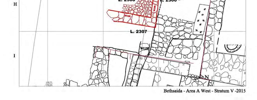
23 23
 and the wall at the west (W 1196). The passage leads to the courtyard in front of the storage house.")
24 L L Figure 29. The paved area Locus Notice the passage (L. 2294) between the pavement (L. 2301) and the wall at the west (W 1196). The passage leads to the courtyard in front of the storage house. 24
25 L L Figure 30. The paved floor at L Notice that the floor ends with four larger stones and lining up with wall, W 1196 creating a passageway L Stratum VI Loci 2302, 2307 Is situated east of the paved structure and revealed patches of limestone crashed packed dirt, of several superimposed floor. The second floor was discovered in an elevation of m. Animal bones were also discovered in the area. The purpose of this area is still unclear although the general notion is that it served as a cultic area. 25


26 Figure 31. L. 2302, a few patches of red packed floor are seen in the center of the picture. Figure 32. Pottery from L includes clear Iron Age IIA / Iron Age I pottery shards, a jar handle with reed impression and a red slip on rim bowl. 26

27 Locus 2307 This locus is located under L Both loci are under the foundation of W 1196 and therefore are designated to Stratum VI. A few patches of floors are revealed, the top is red material, crashed red bricks and the lower is made of crashed limestones. Figure 33. Crashed limestone floor is located under the red material floor. These loci, L2302 and 2307 are designated as Stratum VI because they appear under the foundation of Stratum V, W The loci south of these loci, shown in the left side of the picture are modern disturbances. A few diagnostic shards of pottery and a few bones were discovered on the floors. 27


28 Figure 34. Iron Age IIA pottery shards. A red slip bowl and a neck and a rim of a jar. Figure 35, Bones from L


29 Stratum I-II Other loci of Area A West are located in the south part of the area and are mildly or severely disturbed. No substantial architecture was discovered in these loci, instead there were scattered large boulders and stones. The find from these loci represent all periods of the site. Locus 2292 in square G59, included a fragment of a Roman period beaten earth floor. Under the floor remains of a Hellenistic oven were discovered. Figure 36. Remains of an oven in Locus 2292 Figure 37, L Scattered stones and patches of floors in a severely disturbed locus. 29


30 Below are a few examples of finds from these mixed loci. Some of the finds are unique and exceptional. Figure 38. Locus 2290, Iron chisel, and pottery shards from the Hellenistic period and medieval glazed Mamluk shards. Figure 39. L A medieval "hand grenade". L is located in G59 and is disturbed locus. 30

31 Locus 2293 contained patches of packed floor in an elevation of , but the pottery on that floor was mixture of Medieval to Iron Age IIB. Figure 40. Locus The shards contain Iron Age II B jar, a stopper, Iron Age II B carinated bowl, Iron Age IIB cooking pot. The shining shard is most probably a Roman period "Apulian" ware. Figure 41. Locus 2293, An Iron Age IIB carinated bowl 31

32 Figure 42. Locus 2293, Iron Age IIB jar Locus 2296 is located east of W 1195 and features a disturbed area with finds from all periods of the site. Figure 43. Locus Shards of pottery from all period represented at the site. 32

33 Figure 44. Locus 2296, Galilean bowl with a small handles. Figure 45. Locus 2296 contains Iron Age II B jar, black glazed ETS and medieval pottery. Locus 2298 is located south of the paved area and contains debris of large and medium size rocks. The pottery shards retrieved from this locus includes all representatives of the occupation at the site. 33

34 Figure 46. Locus 2298 is immediately south of the paved area of locus It contains scattered stones. Outstanding is a shard of pottery in Black Figure Style. This style was common in Greece until the mid-sixth century BCE, however, this style continued to be in use in Panathenian amphorae and in some lekythoi designated as funeral offerings. This shard is apparently a fragment of a lekythos. Another Black Figure shard was found a few years ago and may have been part of the same vessel. 34


35 Figure 47. A shard of pottery in Black Figure Style depicting a foot and a segment of a garment. Perhaps a Lekythos. Figure 48. A Black Figure Style shard 35

36 Figure 49. This shard is of a high artistic quality and is here compared with the famous Francois Vase, dated from c. 560 BCE, signed by Clitias and Ergotimos. 36
. A generous donation by Kenneth Bensimon made this excavation possible.")
. Beginning to cut a 10 m.")
37 AREA B Area Supervisor: Kenneth Bensimon Area B excavation project aims to dig what seems to be, an escape tunnel leading from the northeastern room of the palace to the area in between the two city walls. It is named the Bethsaida Escape Royal Tunnel (BERT). A generous donation by Kenneth Bensimon made this excavation possible. The excavation was carried out by a group of Druz workers who did an excellent work. Ken Bensimon helped with this report: Datum: BM (the inside of the inside wall - North of the Syrian trench 5 M). Beginning to cut a 10 m. wide section from the west known tunnel entrance and to the suspected outer face of the inside city wall to the East. The intent of the section was to expose the outside face if the inside city wall. 37

38 Finds: typical military debris from the 1967 war. Other findings; brick pieces, sling stones, and mixed period pottery shards. The face of inside city wall was discovered 6.25 m. from inside face, and about one m. deep from the existing surface. The wall creates a line parallel to the inside face. This width of the wall complies to the other discovered segments of the city wall. Finds: Iron Age II pottery. Figure 50. The Bit Hilani palace, the red is the 2015 excavation season. 38

39 Figure 51, Area B field map. 39
40 40
41 Figure 52. Area B, section A-A looking north. Notice the size of the city wall W160. A modern Syrian military trench was excavated into the wall, field log. The entrance to the tunnel was discovered in 1994 when the Bit Hilani palace was unearthed. However, digging it required skilled engineering efforts which Ken Bensimon kindly offered to the expedition. Ground Penetrating Radar tests done in the past, revealed a possibility of a tunnel leading from the northeastern room of the palace under the city wall. The plan was to find the outer city wall in order to see if there is an entrance or not. Two loci were excavated, locus 3000 is a section of the city wall (W160) and locus 3001 is the entrance to the tunnel at the palace. The city wall (W160) was 6.25 m. wide and had been built similar to the other segments of the excavated city walls. Opposite to the northeastern room of the palace, an offset of the city wall was discovered which created a tower. The offset projects 1.7 m. off the city wall line and is roughly parallel to one meter offset in the inner face of the city wall. The entire 41
.")

42 length of the tower has not been found yet. Two stones in front of the offset may had been a bench or a small high place. Further excavations in this area needs to be done in order to find out the purpose of it. Figure 53. The projection on the city wall (W160). The horizontal scale lays on two stone adjacent to the projection. The purpose of these stone is still unknown. Figure 54. The projection off the city wall W160 marks a tower built into the city wall. Notice the two stones adjacent to the corner of that projection. This projection is echoed 42

43 by a projection on the inner face of the wall. Both projections make the width of the tower 8.5 m. wide. This tower is situated 20 m. north of another tower excavated some years ago. This distance is perhaps an ideal for archers protecting the city wall from the towers. The length of the towr is not yet discovered. Figure 55. The city wall (W160) is in the center of the picture where the state of the preservation of the city wall is more than one meter high. The distance between the two towers is 20 m. 43

44 Finds from this locus include modern artifacts on the first layer and under this deposits Hellenistic and Roman period finds were found. Most of the finds from these period most probably originated from waste thrown over the city walls down into the slope. Figure 56. Pottery shards from the Hellenistic and Roman periods include a Megarian bowl, red slip ETS, and Iron Age shard. 44

45 Figure 57. Megarian shard of pottery showing a palmate. Locus 3001 is the entrance to the tunnel from the within the northeastern rom of the palace. Only about one meter of the tunnel is excavated in the tunnel. In the next year we plan to dig more in this locus. 45


46 Figure 58. The entrance to the tunnel. The finds from locus 3001 were thus far very few and contain Iron Age II B pottery shards. Figure 59. Cypro-Phoenician handle of a jug. 46
47 Figure 60. An Iron Age II B jug Figure 61. An Iron Age II B cooking pot 47
48 Figure 62. An Iron Age II Cooking pot from the palace. 48


49 Area C Figure 63, Area Supervisor, Dr. Nicolae Roddy Figure 64. Area C, patches of the paved street and a segment of a structure at the right center of the picture, near the scale stick. 49

.")
50 Below is the report of Dr. Roddy: AREA C Supervisor: Dr. Nicolae Roddy, assisted by Emmit Wilson Area C, located at the northern end of the mound, was excavated from June 22 July 3, Excavations continued exposing the lower end of the east-west pavement in grid ZZ 28/29, while a probe was opened in a northern room of a courtyard house in D 29. Excavations at the lower end of the paved pavement, which opens to what appears to be a wide public area, revealed a bracket-shaped structure opening toward the east, with an interior area measuring about 1 m. square and with walls 1 m. thick (Fig. 66). The structure s size, shape, and eastward placement in the middle of the open area suggests a shrine, showcase, or perhaps a podium for public address. Unfortunately, the anticipation of uncovering more of its context next year is somewhat dampened by an adjacent modern Syrian trench cutting off the larger open area. 50
51 Moving now to the probe in a northern room of the courtyard house (D 29), a northsouth wall measuring 80 cm in width was discovered (W 1350). Following the wall, excavations revealed that it connects with existing W 219. Area C finds include four coins, a decorated Hellenistic oil lamp, a fishing weight, two beads, a flint blade, and a complete iron nail. 51
52 Figure 65. Area C. Notice loci 5744 and 5743 in both sides of wall W Field log 52
 and a wide opening to the east was found north of wall W 671.")
53 Figure 66. Area C. Locus 5738 consists of patches of pavement and scattered stones slopes down towards the west. A structure consists of three wall (W 673, W 674, W675) and a wide opening to the east was found north of wall W 671. The purpose of this structure is yet unknown. See above the area Supervisor s suggestions. 53

54 Figure 67. Area C, a probe in the "clinic". Locus 5743, wall W 1350 and Locus


55 Figure 68. Area C, locus 5742, a probe in the "clinic", finds include a Rhodian wine jar and Hellenistic and Roman cooking pots. Figure 69. Area C Locus 5738, Hellenistic pottery including Rhodian wine jar shards and Spatter Washed pottery. 55


56 Figure 70. Hellenistic, Early Roman, Spattered Washed Ware with fork impressions Figure 71. Area C, Locus 5740, located south of wall W671. It contains mixed pottery, Hellenistic ware, ETS, flints and EB II combed ware. 56


57 Figure 72. Early Bronze Age II Combed Ware Figure 73. Area C, Locus 5744, a probe in the "clinic" reveals a Hellenistic oil lamp with radial design. 57

58 Figure 74. Area C, Locus 5744, Hellenistic oil lamp with radial design. 58


59 Figure 75, A Seleucid coin, second century BCE 59


60 Area T Figure 76. Area T Supervisor Dr. Gregory Jenks Figure 77, Area T Assistant to Area T Supervisor, Sarah Richardson 60
61 61


62 Figure 78, Area T, field log 62
63 63
64 Figure 79, Area T Section A-A, looking east, field log. Area T is located on the southern slope of the tell and was first opened in During the 2015 season the area was opened only for the final two weeks of the season. A new square (A 68) was opened to the west of the squares first opened in 2013, we removed the baulk between the squares (B, 68, 69) opened in 2012 and 2013, and we opened a probe at the western edge of the original square (B 69) from Removal of the baulk exposed fully the lower courses of a 5m x 5m stone structure (W1202, W1201, W1200, W1203), which is thought to be an interior room of a domestic space from the Mamluk period. It has an interior door on the eastern wall that leads to an adjoining room of the same structure (W 1203). North of the room now fully exposed for the first time we found hard packed floor and an oven (Locus 4025). This confirms the domestic character of the stone structure. The new square opened to the west of the existing excavations (A 69) did not reveal any significant finds. It is possible that we have the remains of a wall running east/west 64
 was opened to ascertain what might lie beneath the level reached in earlier seasons.")
65 on the northern edge of the new square. In the center of the square there is a curved arrangement of field stones that will require further excavation in future seasons. A 1m x 1m probe in the original square (B 69, Locus 4019) was opened to ascertain what might lie beneath the level reached in earlier seasons. It revealed an underlying stone structure, most likely a wall (W 1210), running at an angle that would intersect with the line of the previously exposed Mamluk structures, and separated from the later structures by about 20 cm of soil. Mamuk pottery from this probe suggests that the structure exposed in the probe was from an earlier phase of the Mamluk period. The probe was expanded to 2m x 1m in order to continue exposing the earlier material in the south-west corner of the square, and it revealed further stone structures, with some worked stones suggesting a door or window. Figure 80. Area T, Locus 4018, looking south. 65


66 Figure 81. Area T, probe, Locus 4019, showing wall W1210 runs in east west direction and is situated below a Mamluk structure. Figure 82. Area T, Locus 4020, north of the Mamluk wall W

67 Figure 83. Area T, Locus 4020 looking south 67


68 Figure 84, Area T, segment of a floor in Locus 4024 Figure 85, Area T, the probe in Locus 4019, Mamluk shards, apparently wall W 1210 dates from the Mamluk period as well and the top structure. 68


69 Figure 86. Area T, Locus 4020, Mamluk pottery on the floor of the locus. Figure 87. Area T, a stone spindle whorl from locus 4018 in square A 69 69


70 Figure 88. Area T. Locus 4019, Mamluk and Rashdiyah el Fukhar pottery Figure 89. Area T, Locus 4022, baulk removal. Iron hand cuffs and Mamluk pottery 70


71 Figure 90. Area T, Locus 4019, a shard of pottery with fabric impression Figure 91. Area T, Locus 4019, Mamluk pottery 71

72 Figure 92. Area T, Locus 4019, a Seleucid coin 72
73 BETHSAIDA 2015 SEASON COIN REPORT Dr. Gregory Jenks Nine (9) coins were recovered during the 2015 season. While they have not yet been formally identified, a preliminary examination of the coins suggests the following analysis: A South (no coins) A West (2 coins) B Ptolemaic B Mamluk? Area C (4 coins) B Ayyoubid? B22025 similar to B22030, so probably Tyrian B22030 Tyrian B22034 illegible, probably Seleucid Area T (3 coins) B31261 small blank coin, possibly Mamluk B31262 small classical coin similar to B22030 and B22034 B31263 small silver Ottoman, probably Egypt 73
The Consortium for the Excavations of Bethsaida Bethsaida Biblical Archaeology Project License 2011 Report On the 2011 Excavations Season
 The Consortium for the Excavations of Bethsaida Bethsaida Biblical Archaeology Project License 2011 Report On the 2011 Excavations Season Figure 1, A jasper stone seal depicting a male figure striding
THE SEASON OF A jug from the vicinity of the Roman Temple
 THE SEASON OF 2007 A jug from the vicinity of the Roman Temple 1 BETHSAIDA EXCAVATIONS SEASON OF 2007 DR. RAMI ARAV DIRECTOR, BETHSAIDA EXCAVATIONS PROJECT The excavation season of 2007 extended between
Report on the 2010 excavations season
 The consortium for the excavations of Bethsaida Bethsaida excavations project License G-42/2010 Report on the 2010 excavations season Figure 1, A Gold Coin of Antoninus Pius 138 CE Rami Arav The University
THE CONSORTIUM FOR THE BETHSAIDA EXCAVATION PROJECT LICENSE G-52/2016 REPORT ON THE 2016 EXCAVATION SEASON
 THE CONSORTIUM FOR THE BETHSAIDA EXCAVATION PROJECT LICENSE G-52/20 REPORT ON THE 20 EXCAVATION SEASON RAMI ARAV, CARL SAVAGE, Kate Raphael, VANESSA WORKMAN, KENNETH M. BENSIMON NICOLAE RODDY, Figure 1.
Bethsaida Excavations Project Report on the 2009 season License number: G-45/2009. Rami Arav THE CONSORTIUM FOR THE EXCAVATIONS OF BETHSAIDA
 Bethsaida City Gate Model, Stratum V, made by Duane Pieper Bethsaida Excavations Project Report on the 2009 season License number: G-45/2009 Rami Arav THE CONSORTIUM FOR THE EXCAVATIONS OF BETHSAIDA 1
2005 Bethsaida Field Report
 University of Nebraska at Omaha DigitalCommons@UNO Field Reports Bethsaida Excavations Project 1-1-2005 2005 Bethsaida Field Report Rami Arav University of Nebraska at Omaha, rarav@unomaha.edu Follow this
First announcement concerning the results of the 2005 exploratory season at Tel Kabri
 First announcement concerning the results of the 2005 exploratory season at Tel Kabri Assaf Yasur-Landau Tel Aviv University (assafy@post.tau.ac.il) Eric H. Cline The George Washington University (ehcline@gwu.edu)
New Studies in the City of David The Excavations
 The 2013-2014 Excavations Israel Antiquities Authority The intensive archaeological work on the city of David hill during the period covered in this article has continued in previously excavated areas
In 2014 excavations at Gournia took place in the area of the palace, on the acropolis, and along the northern edge of the town (Fig. 1).
.") Gournia: 2014 Excavation In 2014 excavations at Gournia took place in the area of the palace, on the acropolis, and along the northern edge of the town (Fig. 1). In Room 18 of the palace, Room A, lined
Gournia: 2014 Excavation In 2014 excavations at Gournia took place in the area of the palace, on the acropolis, and along the northern edge of the town (Fig. 1). In Room 18 of the palace, Room A, lined
Jneneh in the Upper Wadi az-zarqa, in North Central Jordan, First Season 2011.
 Jneneh in the Upper Wadi az-zarqa, in North Central Jordan, First Season 2011. Khaled Douglas Jneneh is located in the north-western periphery of the city of Zarqa (grid ref. 250.88E 165.25N), in North
A New Fragment of Proto-Aeolic Capital from Jerusalem
 TEL AVIV Vol. 42, 2015, 67 71 A New Fragment of Proto-Aeolic Capital from Jerusalem Doron Ben-Ami and Yana Tchekhanovets Israel Antiquities Authority The article deals with a fragment of a proto-aeolic
Trench 91 revealed that the cobbled court extends further to the north.
 Report on the 2013 Gournia Excavations The 2013 excavations at Gournia were conducted June 17 July 26 under the aegis of the American School of Classical Studies at Athens and the supervision of the KD
IMTO Italian Mission to Oman University of Pisa 2011B PRELIMINARY REPORT (OCTOBER-DECEMBER 2011)
") IMTO Italian Mission to Oman University of Pisa 2011B PRELIMINARY REPORT (OCTOBER-DECEMBER 2011) The 2011B research campaign took place in the area around Salut from October, 19 th, to December, 16 th.
IMTO Italian Mission to Oman University of Pisa 2011B PRELIMINARY REPORT (OCTOBER-DECEMBER 2011) The 2011B research campaign took place in the area around Salut from October, 19 th, to December, 16 th.
[UNEDITED DRAFT-INTERNAL USE ONLY] Steven M. Ortiz and Samuel R. Wolff
![[UNEDITED DRAFT-INTERNAL USE ONLY] Steven M. Ortiz and Samuel R. Wolff](/thumbs/96/128776431.jpg "[UNEDITED DRAFT-INTERNAL USE ONLY] Steven M. Ortiz and Samuel R. Wolff") Tel Gezer G-56/2007 p. 1 Tel Gezer, 2007 Excavation Summary Report [UNEDITED DRAFT-INTERNAL USE ONLY] Steven M. Ortiz and Samuel R. Wolff Introduction The second season of the renewed excavations of Tel
Tel Gezer G-56/2007 p. 1 Tel Gezer, 2007 Excavation Summary Report [UNEDITED DRAFT-INTERNAL USE ONLY] Steven M. Ortiz and Samuel R. Wolff Introduction The second season of the renewed excavations of Tel
Pella in Jordan Early Bronze Age Fortifications, a Late Bronze Age Palace and a Hellenistic Villa. by Stephen Bourke Introduction
 The Near Eastern Archæology Foundation BULLETIN NUMBER 55 February 2012 Pella in Jordan 2011 Early Bronze Age Fortifications, a Late Bronze Age Palace and a Hellenistic Villa by Stephen Bourke Introduction
218 R. S. BORAAS AND S. H. HORN
 were able to show a sequence of ceramic corpora much more fully representative than those available from the occupation surfaces and structures higher on the mound. This ceramic series obtained from D.
The Greek-Swedish-Danish Excavations at Kastelli, Khania 2010 a short report
 The Greek-Swedish-Danish Excavations at Kastelli, Khania 2010 a short report During six weeks from 19 July to 27 August the Greek-Swedish-Danish Excavations continued work in the Ag. Aikaterini Square
The importance of Jerusalem for the study of Near Eastern history and. archaeology and for the study of the Biblical text (both old and new) cannot
 cannot") Setting the Clock in the City of David: Establishing a Radiocarbon Chronology for Jerusalem's Archaeology in Proto-historical and Historical Times Yuval Gadot, Johana Regev, Helena Roth and Elissabeta
Setting the Clock in the City of David: Establishing a Radiocarbon Chronology for Jerusalem's Archaeology in Proto-historical and Historical Times Yuval Gadot, Johana Regev, Helena Roth and Elissabeta
ANNUAL REPORT: ANCIENT METHONE ARCHAEOLOGICAL PROJECT 2014 FIELD SCHOOL
 ANNUAL REPORT: ANCIENT METHONE ARCHAEOLOGICAL PROJECT 2014 FIELD SCHOOL Director(s): Co- Director(s): Professor Sarah Morris, Cotsen Institute of Archaeology, UCLA John K. Papadopoulos, Cotsen Institute
aiton.new 1/4/04 3:48 AM Page 2
 aiton.new 1/4/04 3:48 AM Page 2 Below: An aerial view of area A of the excavations. A massive square building that appears to be a fortress was discovered in this area at the top of the tell. aiton.new
IKLAINA ARCHAEOLOGICAL PROJECT 2016 FIELD REPORT Michael B. Cosmopoulos
 IKLAINA ARCHAEOLOGICAL PROJECT 2016 FIELD REPORT Michael B. Cosmopoulos Introduction The overarching objective of the Iklaina project is to test existing hierarchical models of state formation in Greece
220 NOTES AND NEWS REFERENCES
 220 NOTES AND NEWS pottery uncovered in each building, the inscription (found during the 2008 season), the seal and various metal objects. The site functioned as a rich urban centre. One would expect mention
Labraunda Preliminary report
 Labraunda 2012. Preliminary report The excavations at Labraunda this year were very successful and lasted for eight weeks. Our main new discovery is obviously the gold coin from Philip II discovered in
Azoria 2004 B700 Final Trench Report RQC
 Azoria 2004 B700 Final Trench Report RQC B700 is a room -2.5m by 4.5m, bounded by wall B711 to north, wall B703 to east, wall B706 to south, and wall B717 to west. B700 is an Archaic storeroom with an
Amarna Workers Village
 Amarna Workers Village The Egyptian city of Amarna was the pet building project of the pharaoh Akhenaten, who oversaw construction of his new capital between 1346 and 1341 BCE. The city was largely abandoned
Ancient Greek Buildings/ Fortifications. Matthew Jackson
 Ancient Greek Buildings/ Fortifications Matthew Jackson What is a fortification? -The combination of terrain and available materials to form a means of defense against potential attackers -Represent the
The Tel Burna Archaeological Project Report on the First Season of Excavation, 2010
 The Tel Burna Archaeological Project Report on the First Season of Excavation, 2010 By Itzick Shai and Joe Uziel Albright Institute for Archaeological Research Jerusalem, Israel April 2011 The site of
AREA A. BASTIAAN VAN ELDEREN Calvin Theological Seminary, Grand Rapids, Michigan
 AREA A BASTIAAN VAN ELDEREN Calvin Theological Seminary, Grand Rapids, Michigan During the 1968 and 1971 seasons six Squares were excavated in Area A, all but one (A.6) to bedrock.' Approximately threefourths
TELL ES-SWEYHAT EXPEDITION TO SYRIA
 TELL ES-SWEYHAT EXPEDITION TO SYRIA THOMAS A. HOLLAND The fifth season of archaeological excavations was conducted during October and November 1991 at the Early Bronze Age site of Tell Es-Sweyhat, which
THE EL-QITAK PROJECT. oi.uchicago.edu
 oi.uchicago.edu THE EL-QITAK PROJECT T H O M A S - L - M C C L E L L A N T he 1987 season at el-qitar ran from May 2 t o July 29th and marked the last major season of excavation there because the site
CARLUNGIE EARTH HOUSE
 Property in Care (PIC) ID: PIC015 Designations: Scheduled Monument (SM90059) Taken into State care: 1953 (Guardianship) Last reviewed: 2004 HISTORIC ENVIRONMENT SCOTLAND STATEMENT OF SIGNIFICANCE CARLUNGIE
BRAP BEAT. Results of Week 2 By Kent Bramlett
 BRAP BEAT Results of Week 2 By Kent Bramlett The second week has produced real progress and advancement of our understanding in each of the three areas. The Qasr team removed the 1st century AD pavement
GEZER 2013 REPORT. Steven M. Ortiz and Samuel R. Wolff. (License No. G ) Figure 1: Aerial (north at top) INTRODUCTION
 Figure 1: Aerial (north at top) INTRODUCTION") 1 Steven M. Ortiz and Samuel R. Wolff GEZER 2013 REPORT (License No. G57-2013) Figure 1: Aerial (north at top) INTRODUCTION The Tel Gezer Excavation project is a long-term joint American-Israeli project
1 Steven M. Ortiz and Samuel R. Wolff GEZER 2013 REPORT (License No. G57-2013) Figure 1: Aerial (north at top) INTRODUCTION The Tel Gezer Excavation project is a long-term joint American-Israeli project
Report on the excavations on the site Novopokrovskoe II in V. Kol'chenko, F. Rott
 Report on the excavations on the site Novopokrovskoe II in 2016 V. Kol'chenko, F. Rott In 2016 the Novopokrovskiy archeological group of the Institute of History and Heritage of the National Academy of
oi.uchicago.edu TALL-E BAKUN
 TALL-E BAKUN ABBAS ALIZADEH After I returned in September 1991 to Chicago from Cambridge, Massachusetts, I began preparing for publication the results of 1937 season of excavations at Tall-e Bakun, one
The Yingtianmen Gate-site of the Sui and Tang Eastern Capital in Luoyang City
 Nandajie The Yingtianmen Gate-site of the Sui and Tang Eastern Capital in Luoyang City Tang Luoyang City-site Archaeological Team, Institute of Archaeology, Chinese Academy of Social Sciences Key words:
Draft Report. 7. Excavations in the temenos gateway, Area (TG5) Author - D. A. Welsby Period 1-2. Period 1. Period 2. Derek A.
 Author - D. A. Welsby Period 1-2. Period 1. Period 2. Derek A.") 7. Excavations in the temenos gateway, Area (TG5) Derek A. Welsby When Griffith excavated the temples at Kawa in 1929-31, work followed by that of Macadam and Kirwan in the winter of 1935-6, the temenos
7. Excavations in the temenos gateway, Area (TG5) Derek A. Welsby When Griffith excavated the temples at Kawa in 1929-31, work followed by that of Macadam and Kirwan in the winter of 1935-6, the temenos
IMTO Italian Mission to Oman. University of Pisa SUMHURAM. Preliminary Report. February March 2016 (SUM16A)
") IMTO Italian Mission to Oman University of Pisa SUMHURAM Preliminary Report February March 2016 (SUM16A) PRELIMINARY REPORT (SUM16A) February March 2016 The first IMTO s campaign of 2016 (SUM16A), under
IMTO Italian Mission to Oman University of Pisa SUMHURAM Preliminary Report February March 2016 (SUM16A) PRELIMINARY REPORT (SUM16A) February March 2016 The first IMTO s campaign of 2016 (SUM16A), under
Land off Birdie Way, Rush Green, Hertford, Hertfordshire
 Land off Birdie Way, Rush Green, Hertford, Hertfordshire An Archaeological Evaluation for Bride Hall Development Limited by Sarah Coles Thames Valley Archaeological Services Site Code RGH00/ 01 January
THE HEUGH LINDISFARNE
 LINDISFARNE COMMUNITY ARCHAEOLOGY THE HEUGH LINDISFARNE Archaeological excavations in June 2017 Invitation to volunteers THE HEUGH, LINDISFARNE, NORTHUMBERLAND: ARCHAEOLOGICAL EXCAVATIONS 2017 INTRODUCTION
Gorse Stacks, Bus Interchange Excavations Interim Note-01
 Gorse Stacks, Bus Interchange Excavations 2015 Prepared for: Cheshire West & Chester Council Interim Note-01 1 Introduction & Summary Background Since c. 2000 investigations associated with redevelopment
Cetamura Results Prior to 2000
 Cetamura Results Prior to 2000 Excavations at the hilltop of Cetamura del Chianti (695m above sea level) near Siena by Florida State University have unearthed a habitation with a long and diverse history,
IKLAINA ARCHAEOLOGICAL PROJECT 2012 FIELD REPORT
 IKLAINA ARCHAEOLOGICAL PROJECT 2012 FIELD REPORT Michael B. Cosmopoulos The sixth season of the Iklaina Archaeological Project was conducted for six weeks in June and July 2012. Τhe project is conducted
Plates. Kom Firin I 193. Plate 96 View of the southwestern part of Kom Firin, looking west-southwest.
 Plates Plate 96 View of the southwestern part of Kom Firin, looking west-southwest. Plate 97 Ramesside temple: wall 0157 and clean sand 0189 (TG), view to north. Plate 98 Ramesside temple: wall 0135 (TD),
IKLAINA ARCHAEOLOGICAL PROJECT 2015 FIELD REPORT Michael B. Cosmopoulos
 IKLAINA ARCHAEOLOGICAL PROJECT 2015 FIELD REPORT Michael B. Cosmopoulos The 2015 season of the Iklaina project took place from June 1 to July 7. The project is conducted under the auspices of the Athens
BROOKLYN COLLEGE EXCAVATIONS AT THE NEW UTRECHT REFORMED CHURCH
 BROOKLYN COLLEGE EXCAVATIONS AT THE NEW UTRECHT REFORMED CHURCH SUMMER 2002 The New Utrecht Reformed Church is the fourth oldest church in Brooklyn. Founded in 1677, in the heart of the Dutch town of New
TH E FIRST SEASON of investigations at the
 QUSEIR AL-QADIM Janet H. Johnson & Donald Whitcomb TH E FIRST SEASON of investigations at the ancient port of Quseir al-qadim on the Red Sea in Egypt took place in winter, 1978; the investigations were
Department of Tourism, Culture and Recreation Provincial Archaeology Office 2012 Archaeology Review February 2013 Volume 11
 Department of Tourism, Culture and Recreation Provincial Archaeology Office 2012 Archaeology Review February 2013 Volume 11 Area 14 of FjCa-14 in Sheshatshiu, portion of feature in southeast corner of
REPORT ON THE 2004 FIELDWORK SEASON OF THE UNIVERSITY OF CALIFORNIA BERKELEY AT THE ARCHAEOLOGICAL SITE OF EL-HIBEH, BENI-SUEF GOVERNORATE
 REPORT ON THE 2004 FIELDWORK SEASON OF THE UNIVERSITY OF CALIFORNIA BERKELEY AT THE ARCHAEOLOGICAL SITE OF EL-HIBEH, BENI-SUEF GOVERNORATE By Carol A. Redmount, Project Director The archaeological site
The City-Wall of Nineveh
 The City of Nineveh Nineveh has a very long history, with finds dating already back at fifth millennium. As part of the Assyrian empire, the city served as a regional center during the Middle and Early
Excavations at Tell Timai 2010 University of Hawaii Season 2 May 20 to 14 July 2010
 Excavations at Tell Timai 2010 University of Hawaii Season 2 May 20 to 14 July 2010 Directors Professor Robert Littman, littman@hawaii.edu Dr. Jay Silverstein, drjsilverstein@gmail.com Dr. Nicholas Hudson
Ground Penetrating Radar Survey Report:
 Ground Penetrating Radar Survey Report: German Hospice in Jerusalem, Israel Data Acquired June 19, 2003 Report compiled August 26, 2003 Survey and Report Published by Mnemotrix Systems, Inc. Copyright
Architectural Analysis in Western Palenque
 Architectural Analysis in Western Palenque James Eckhardt and Heather Hurst During the 1999 season of the Palenque Mapping Project the team mapped the western portion of the site of Palenque. This paper
Antinoupolis. Ongoing Destruction. Pre-2006 crops. Modern cemetery covering. ancient cemetery. Antinoupolis, ancient city. North cemetery (ancient).
.") Antinoupolis Ongoing Destruction Ongoing Destruction North cemetery (ancient). Pre-2006 crops Modern cemetery covering ancient cemetery. Antinoupolis, ancient city. Modern village of el Sheikh Abada Nile
Antinoupolis Ongoing Destruction Ongoing Destruction North cemetery (ancient). Pre-2006 crops Modern cemetery covering ancient cemetery. Antinoupolis, ancient city. Modern village of el Sheikh Abada Nile
Archaeological Investigations Project South East Region SOUTHAMPTON 2/842 (C.80.C004) SU
 SU") SOUTHAMPTON City of Southampton 2/842 (C.80.C004) SU 4382 1336 125 BITTERNE ROAD WEST, SOUTHAMPTON Report on the Archaeological Evaluation Excavation at 125 Bitterne Road West, Southampton Russel, A. D
SOUTHAMPTON City of Southampton 2/842 (C.80.C004) SU 4382 1336 125 BITTERNE ROAD WEST, SOUTHAMPTON Report on the Archaeological Evaluation Excavation at 125 Bitterne Road West, Southampton Russel, A. D
Erica Kinias Brown University, Department of the History of Art and Architecture
 Erica Kinias Brown University, Department of the History of Art and Architecture Archaeological Institute of America Jane C. Waldbaum Scholarship Fund Research Outcomes With the generous support from the
ARDESTIE EARTH HOUSE HISTORIC ENVIRONMENT SCOTLAND STATEMENT OF SIGNIFICANCE. Property in Care no: 24
 Property in Care no: 24 Designations: Scheduled Monument (SM90021) Taken into State care: 1953 (Guardianship) Last reviewed: 2004 HISTORIC ENVIRONMENT SCOTLAND STATEMENT OF SIGNIFICANCE ARDESTIE EARTH
Excavation in Area G: squares m/14-15, new building BG1 (trench supervisor: Cleto Carbonara)
") Excavation in Area G: squares m/14-15, new building BG1 (trench supervisor: Cleto Carbonara) The excavation in the Area G started in the 1 st October has two main purposes: To understand the real extension
Excavation in Area G: squares m/14-15, new building BG1 (trench supervisor: Cleto Carbonara) The excavation in the Area G started in the 1 st October has two main purposes: To understand the real extension
By : K. Blouin, Th. Faucher, N. Hudson, M. Kenawi, A. Kirby, R. Mairs, G. Marchiori, M. Van Peene
 THMUIS, A NEW LAND IN THE EASTERN NILE DELTA FIRST CANADIAN MISSION AT THMUIS By : K. Blouin, Th. Faucher, N. Hudson, M. Kenawi, A. Kirby, R. Mairs, G. Marchiori, M. Van Peene The first Canadian Mission
ANNA MORPURGO-DAVIES GERALD CADOGAN A SECOND LINEAR A TABLET FROM PYRGOS
 ANNA MORPURGO-DAVIES GERALD CADOGAN A SECOND LINEAR A TABLET FROM PYRGOS In May 1975 a second broken Linear A tablet was found during study of the pottery from the Minoan country house at Pyrgos near the
Virtual World Project
 Virtual World Project Aphek Antipatris Introduction Tel Aphek rises 15 meters above the source of the Yarkon River, about 12 kilometers east of Tel Aviv. Aphek, with an area of 30 acres, appears as a raised
HERODIUM The Grand Memorial for the Builder King
 HERODIUM The Grand Memorial for the Builder King http://herodium.org/home Herodium is one of the most important and unique building complexes built by Herod King of Judea during the first century BCE,
In September, 1966, an
 ANNE S. ROBERTSON, D LITT THE ROMAN CAMP(S) ON HILLSIDE FARM, DUNBLANE, PERTHSHIRE This paper is published with the aid of a grantfrom H.M.Treasury In September, 1966, an emergency excavation was begun,
NEW CARD DESIGNS. Card designs and their descriptions EARLY AND MIDDLE BRONZE AGES. Master Card Classic Credit
 NEW CARD DESIGNS Card designs and their descriptions EARLY AND MIDDLE BRONZE AGES Master Card Classic Credit Juglet, Red Polished III Ware Juglet, Red Polished Ware (Early Bronze Age 2500-2000 BC and Middle
Wessex Archaeology. Little Stubbings, West Amesbury, Salisbury, Wiltshire. Archaeological Watching Brief. Ref:
 Wessex Archaeology Little Stubbings, West Amesbury, Salisbury, Wiltshire Ref: 63280.02 March 2007 LITTLE STUBBINGS, WEST AMESBURY, NR SALISBURY, WILTSHIRE ARCHAEOLOGICAL WATCHING BRIEF Prepared for: P
Table of Contents. Introduction Excavation Results Cavern Cavern Cavern Square J Square M28..
 Table of Contents Introduction.... 2 Excavation Results..... 4 Cavern 1..... 4 Cavern 2......... 9 Cavern 3......... 12 Square J19........ 15 Square M28.. 17 Square O21... 18 Square O28... 20 Square P21,
Virtual World Project
 Virtual World Project Arad Introduction Tel Arad is located in Israel s northeastern Negev desert, about 30 kilometers eastnortheast of Beersheba. The 25-acre site was home to two distinct settlements.
ΑΡΧΑΙΟΤΗΤΕΣ ΚΑΙ ΜΝΗΜΕΙΑ APT ΟΛΙΔΟΚΟΡΙΝΘΙ ΑΣ
 144 ΑΡΧΑΙΟΛΟΓΙΚΟΝ ΔΕΛΤΙΟΝ 20 (1965): ΧΡΟΝΙΚΑ ΑΡΧΑΙΟΤΗΤΕΣ ΚΑΙ ΜΝΗΜΕΙΑ APT ΟΛΙΔΟΚΟΡΙΝΘΙ ΑΣ EXCAVATIONS IN CORINTH, 1964 The principal excavations at Corinth in the spring of 1964 were conducted by Mrs. Saul
Excavations at El Palenque, San Martín Tilcajete: A Late Formative Subregional Center in the Oaxaca Valley, México
 FAMSI 2000: Elsa M. Redmond Excavations at El Palenque, San Martín Tilcajete: A Late Formative Subregional Center in the Oaxaca Valley, México Research Year: 1999 Culture: Zapotec Chronology: Late Pre-Classic
Preliminary Report on the Results of the 2009 Excavation Season at Tel Kabri
 Preliminary Report on the Results of the 2009 Excavation Season at Tel Kabri Assaf Yasur-Landau Leon Recanati Institute for Maritime Studies University of Haifa Eric H. Cline Dept of Classical and Semitic
Preliminary Report on the Results of the 2017 Excavation Season at Tel Kabri. Andrew Koh,
 Preliminary Report on the Results of the 2017 Excavation Season at Tel Kabri Assaf Yasur-Landau, * Eric H. Cline, Andrew Koh, and Alexandra Ratzlaff The 2017 excavations at Tel Kabri, the capital of a
FOUNDATIONS OF ARCHAEOLOGY A WALK IN VERNDITCH CHASE
 FOUNDATIONS OF ARCHAEOLOGY A WALK IN VERNDITCH CHASE 1. A Tale of two Long Barrows Long barrows were constructed as earthen or drystone mounds with flanking ditches and acted as funerary monuments during
Taxel (pottery analysis) and S. Pavel (photography). Ramat Rabel, 2005
 and S. Pavel (photography). Ramat Rabel, 2005") NOTES AND NEWS 227 Zabala to a range within the first century BCE and the first century CEo While the function of the various buildings remains unknown, as does the nature of the Roman settlement on the
NOTES AND NEWS 227 Zabala to a range within the first century BCE and the first century CEo While the function of the various buildings remains unknown, as does the nature of the Roman settlement on the
New Archaeological Discoveries South of the Hanyuan Hall at the Daming Palace of Tang Dynasty
 New Archaeological Discoveries South of the Hanyuan Hall at the Daming Palace of Tang Dynasty The Xi an Tang City Archaeology Team, IA, CASS Key words: Imperial Palaces-China-Tang Dynasty Hanyuan Hall
Provincial Archaeology Office Annual Review
 2017 Provincial Archaeology Office Annual Review Provincial Archaeology Office Department of Tourism, Culture, Industry and Innovation Government of Newfoundland and Labrador March 2018 Volume 16 A brief
4. Bronze Age Ballybrowney, County Cork Eamonn Cotter
 4. Bronze Age Ballybrowney, County Cork Eamonn Cotter Illus. 1 Location map of the excavated features at Ballybrowney Lower (Archaeological Consultancy Services Ltd, based on the Ordnance Survey Ireland
Excavations at Vagnari 2017
 Excavations at Vagnari 2017 Maureen Carroll Since 2012, our excavations at the Roman imperial estate at Vagnari in Puglia (Fig. 1) have concentrated on the northern edge of the village (vicus) of the estate
The Mortuary Temple of Merenptah on the West Bank at Luxor In Egypt by Mark Andrews
 The Mortuary Temple of Merenptah on the West Bank at Luxor In Egypt by Mark Andrews The mortuary temple of Merenptah (Merneptah), Ramesses II 's thirteenth son and successor, was mostly destroyed long
B 1200: The Napatan palace and the Aspelta throne room.
 B 1200: The Napatan palace and the Aspelta throne room. The labyrinthine mud brick walls southwest of B 800 are the remains of the Napatan palace, designated "B 1200," at Jebel Barkal (fig. 1). Until now
Leptis Magna. 9 LEPTIS MAGNA s NORTH COAST
 9 LEPTIS MAGNA s NORTH COAST The following observations were made on August 24, 25 and 26, 2000, thanks to the kind hospitality of the late Professor André Laronde during his year 2000 campaign of the
This theme gives us a way to begin to think and talk about the human figure within Greek Art. It also addresses the Greek search for ideal
 This theme gives us a way to begin to think and talk about the human figure within Greek Art. It also addresses the Greek search for ideal mathematical proportions in the figure and in architecture. We
III. THE EARLY HELLADIC POTTERY FROM THE MASTOS IN THE BERBATI VALLEY, ARGOLID
 III. THE EARLY HELLADIC POTTERY FROM THE MASTOS IN THE BERBATI VALLEY, ARGOLID by JEANNETTE FORSÉN The Swedish investigations of the hillock Mastos in the western part of the Berbati valley, ca. 3 km south
The Italian Archaeological Mission in Sudan Ca Foscari University of Venice
 The Italian Archaeological Mission in Sudan Ca Foscari University of Venice Karima (Sudan) November-December 2012 The 2012 season of the Italian Archaeological Mission at Jebel Barkal was carried out between
Urbanization and Landscape Change along Croatia s Adriatic Sea:
 Urbanization and Landscape Change along Croatia s Adriatic Sea: ANT477 Field Research in Archaeology Croatia (Summer 2016); 3 cr May June 12 Gen.Ed.: Cultural Diversity and International Perspectives;
An archaeological watching brief at the Sixth Form College, North Hill, Colchester, Essex
 An archaeological watching brief at the Sixth Form College, North Hill, Colchester, Essex July 2001 on behalf of Colchester Borough Council CAT project ref.: 01/7B Colchester Museum accession code: 2001.126
oi.uchicago.edu ARCHEOLOGY
 ARCHEOLOGY Janet H. Johnson and Donald Whitcomb Quseir al-qadim The small port of Quseir al-qadim, Egypt, is situated on the north bank of the Wadi Quseir al-qadim where the wadi meets the Red Sea; it
Tel Achziv. Preliminary Report The First Season of Excavations. No. G Directed by. Michael Jasmin (CNRS) and Yifat Thareani (NGSBA)
 and Yifat Thareani (NGSBA)") Tel Achziv Preliminary Report - 2014 The First Season of Excavations No. G64-2014 Directed by Michael Jasmin (CNRS) and Yifat Thareani (NGSBA) Scientific Advisor David Ilan (NGSBA) 1 Introduction Tel Achziv
Tel Achziv Preliminary Report - 2014 The First Season of Excavations No. G64-2014 Directed by Michael Jasmin (CNRS) and Yifat Thareani (NGSBA) Scientific Advisor David Ilan (NGSBA) 1 Introduction Tel Achziv
An archaeological evaluation at 14 Vineyard Street, Colchester, Essex March 2006
 An archaeological evaluation at 14 Vineyard Street, Colchester, Essex March 2006 report prepared by Ben Holloway commissioned by Colchester Borough Council CAT project code: 06/4b Colchester Museums accession
A Near Eastern Megalithic Monument in Context
 Special Volume 3 (2012), pp. 143 147 Mike Freikman A Near Eastern Megalithic Monument in Context in Wiebke Bebermeier Robert Hebenstreit Elke Kaiser Jan Krause (eds.), Landscape Archaeology. Proceedings
: southern pilaster of the entrance. The tomb owner, Redi, is depicted in painted raised relief ( a 8014) Plate 15
 Plate 15") 15. 2086: southern pilaster of the entrance. The tomb owner, Redi, is depicted in painted raised relief ( a 8014) Plate 15 16. 2086: south wall. Redi is seated with a woman, receiving a lotus, and entertained
15. 2086: southern pilaster of the entrance. The tomb owner, Redi, is depicted in painted raised relief ( a 8014) Plate 15 16. 2086: south wall. Redi is seated with a woman, receiving a lotus, and entertained
6 The excavation so far 6.1 Project history Monte Polizzo is 6 km. northwest of Salemi, in Trapani province, western Sicily (37 56 N, E.
 6 The excavation so far 6.1 Project history Monte Polizzo is 6 km. northwest of Salemi, in Trapani province, western Sicily (37 56 N, 12 46 E. The site consists of an interconnected group of ridges. The
archeological site LOS MILLARES
 archeological site LOS MILLARES Aerial view of the plain of Los Millares between the Rambla de Huéchar and the River Andarax The archaeological site of Los Millares is located in the township of Santa
Excavations in a Medieval Market Town: Mountsorrel, Leicestershire,
 Excavations in a Medieval Market Town: Mountsorrel, Leicestershire, by John Lucas Mountsorrel is situated 12 kms north of Leicester and forms a linear settlement straddling the A6, Leicester to Derby road.
South East Region SOUTHAMPTON 3/1050 (E.80.H006) SU
 SU") SOUTHAMPTON 3/1050 (E.80.H006) SU 43351328 16 HAWKESWOOD ROAD Report on the Archaeological Observations at 16 Hawkeswood Road, Bitterne Manor Russil, A & Smith, M Southampton : Southampton City Council
SOUTHAMPTON 3/1050 (E.80.H006) SU 43351328 16 HAWKESWOOD ROAD Report on the Archaeological Observations at 16 Hawkeswood Road, Bitterne Manor Russil, A & Smith, M Southampton : Southampton City Council
INTERNET ID ΑΔΑ: 76ΕΝΓ-9ΓΔ. Athens, 27/10/2014. Ref. No. ΥΠΠΟΑ/ΓΔΑΠΚ/ΔΒΜΑ/ΤΕΞΕΙ/278037/ /9820/540 NOTIFICATION TO:
 1 Ground Penetrating Radar Rhodes, Greece-Kahal Shalom Synagogue Pilot Project Report January, 2015 Professor Richard Freund, Project Director, University of Hartford Professor Harry Jol, Chief Geoscientist,
The$Cisterns$of$No.on$ $ Angela$Commito$
 The$Cisterns$of$No.on$ $ Angela$Commito$ Aerial$view$of$No.on,$looking$northeast$ View$looking$up$cistern$sha
E X C A V A T I O N O F T H E E A R L Y I R O N A G E S E T T L E M E N T A T A Z O R I A By Donald C. Haggis and Margaret S. Mook
 E X C A V A T I O N O F T H E E A R L Y I R O N A G E S E T T L E M E N T A T A Z O R I A By Donald C. Haggis and Margaret S. Mook Figure 1. B3500: Sondage from the east, showing Archaic cobble fill and
An archaeological excavation at 193 High Street, Kelvedon, Essex September 2009
 An archaeological excavation at 193 High Street, Kelvedon, Essex September 2009 report prepared by Ben Holloway and Howard Brooks on behalf of Marden Homes CAT project ref.: 09/4g NGR: TL 8631 1913 (c)
Discover archaeology and the ancient art in The Louvre Museum (Paris, France) & Dig in the Roman City of Sanisera (Menorca, Spain)
 & Dig in the Roman City of Sanisera (Menorca, Spain)") Course 030 Discover archaeology and the ancient art in The Louvre Museum (Paris, France) & Dig in the Roman City of Sanisera (Menorca, Spain) 1. General Information This program, which has been scheduled
Course 030 Discover archaeology and the ancient art in The Louvre Museum (Paris, France) & Dig in the Roman City of Sanisera (Menorca, Spain) 1. General Information This program, which has been scheduled
IMTO Italian Mission to Oman University of Pisa PRELIMINARY REPORT (FEBRUARY-MARCH 2009)
") IMTO Italian Mission to Oman University of Pisa PRELIMINARY REPORT (FEBRUARY-MARCH 2009) SALUT PRELIMINARY REPORT (FEBRUARY-MARCH 2009) INTRODUCTION The archaeological excavation on the site of Salut was
IMTO Italian Mission to Oman University of Pisa PRELIMINARY REPORT (FEBRUARY-MARCH 2009) SALUT PRELIMINARY REPORT (FEBRUARY-MARCH 2009) INTRODUCTION The archaeological excavation on the site of Salut was