Excavations at Tell Timai 2010 University of Hawaii Season 2 May 20 to 14 July 2010
|
|
|
- Elmer Golden
- 5 years ago
- Views:
Transcription
1 Excavations at Tell Timai 2010 University of Hawaii Season 2 May 20 to 14 July 2010 Directors Professor Robert Littman, littman@hawaii.edu Dr. Jay Silverstein, drjsilverstein@gmail.com Dr. Nicholas Hudson Dr. Joshua Trampier Summary An archaeological team sponsored by the University of Hawaii led by Professor Robert Littman and Dr. Jay Silverstein conducted, geophysical survey, auger coring, excavations and mapping between May 20 to 14 July The geophysical survey focused on identifying areas associated with monumental ruins found in the canal on the south edge of the tell in 2009, investigating a possible cemetery area to the southwest, and locating the ancient harbor of Thmuis. A program of auger coring was conducted in the surrounding area of the tell to search for paleochannels of the Mendesian Branch of the Nile. Excavations and mapping focused on phasing the limestone temple in the north, investigating the architectural features revealed by magnetometer survey in the north, to the east of the temple, continuing the cleaning and mapping of the north kiln area excavations, and mapping exposed architecture east of the kiln area and in the area south of the modern cemetery on the west edge of the tell. Some mapping and cleaning was also conducted south of the modern cemetery on the west side of the tell. Results from the 2010 season include indications of two paleochannels of the Mendesian Branch of the Nile, possible evidence of a harbor inlet on the north portion of the tell, phasing and dating of the kiln complex, north temple platform, and the structures located just south of the possible harbor, and structural and topographic mapping across the northern portion of the tell. Excavation units are denoted by their position on the 50 m alpha-numeric grid zone that was established in the 2007 survey and by the unit number within that grid (in the case where a unit falls between two or more grids, the grid identification for the unit is based on the 50m grid unit in which the southwest corner of the unit falls). Figure 1 illustrates the site grid system and the magnetometry data results in the north section of the tell and the associated excavations. Specific results of the 2010 season follow. Geophysical Survey and Auger Sampling Beginning in May 2010, Dr. Tomasz Herbich conducted a geophysical magnetometer survey of several section of the tell including the southern Grid U22, the southeastern Grid A20, and the suspected harbor area, N6-N7. Only the harbor area survey proved fruitful, revealing extensive buried mudbrick architecture and a possible harbor entrance over an area of approximately 5000 sq.m (Figure 2)..Based on the results of the geophysical survey, excavations were conducted to explore and date the hidden architecture. The harbor study was complemented by the search for the paleochannels of the Mendesian branch of the Nile with a total of 21 auger core samples used to search for geomorphological signatures of ancient waterways. The presence of soils and sands consistent with relict channels suggests two areas for further study (Figure 3). Drill coring operations were overseen by Veronica Morriss and Mohammed Abdulaziz Gabr. The aims of this research effort involve articulating the ancient channels of the Mendesian branch of the Nile in relation to Tell Timai s cultural history, and to evaluate how environmental shifts may relate to the settlement shift from Tell el-rub a to Tell Timai. Drill core locations around Tell Timai (Figure 3) were captured with the aid of a Garmin V handheld GPS unit capable of measuring 1
2 one s position on the Earth to an accuracy of +/- 2m. Core elevations were measured more precisely using a combination of the Leica laser total station and a Pentax dumpy level that captured this information to an accuracy of +/- 2 cm. Working with a colleague from the Geology Department of Mansoura University, Dr. Adam Shehat, this project will integrate sedimentological and remote sensing information to investigate the paleo-environment of the region. Future transects will explore the presence or absence of natural or artificial channels to the south of Tell Timai and between Tell Timai and Tell el-rub a. Site Survey Mapping The goals of the survey were: (1) plotting the excavation units; (2) cleaning and mapping standing architecture in exposed areas planned for construction in Units P6 and P7; (3) mapping the locations and elevations in the auger drill cores; and (4) topographic survey to the west and northwest of the M6 temple platform area. Spatial information for excavation areas and mapping data were collected with Leica laser total station. Locations of excavation units were plotted, and in-situ objects and features that were particularly important to site phasing and interpretation were point-provenienced and mapped. In the P6 and P7 area multiple phases of architecture, including a large complex with a lime plaster floor bordered by mudbrick walls topped with red brick, a series of limestone and red brick platforms, and a cellular structure that appeared to be a grainery were mapped with the assistance of inspectorate of the Daqaliyeh taftish (Figure 4). In addition, a topographic survey was begun in the northern spur of Tell Timai around the periphery of the M6 to O6 depression, with points taken in roughly 5m intervals. In future seasons we hope to expand the topographic survey to cover the entire tell. Mapping at Kiln Complex in O6 and O7 During the 2010 season, 8 open units in a kiln workshop area were cleaned and plan-mapped. The assigned unit numbers for this area are: O6-17, O6-18, O6-19, O6-20, O7-09, O7-10, O7-11 (Figure 5), and O7-12. A series of mudbrick walls and a high density of kilns were mapped and sampled. The kilns show differing construction styles and sizes perhaps indicating the changes in type or manufacturing over time. Data collected allow dating of the kiln complex and sequencing the phases of construction, leveling, and re-use of the manufacturing center. Intrusive mudbrick walls appear in many of the sections at the later phases. M6 Temple Area Work in area M6 continued investigations begun in The purpose of excavation in the 2010 season was to focus on the function of the limestone temple structure, to phase the construction, and develop an understanding of the relationship of the building with the surrounding architecture. Three units were opened in the area around the temple foundation. Excavation exposed a large platform that runs south and west beyond the limit of the unit from the southern edge of the temple. The hypothesis being considered was that the platform encircled the temple to the south, west and north. The architectural evidence indicates a construction sequence in which a leveled area and platform represent an earlier phase followed by the foundation cut and temple construction. Preliminary ceramic evidence from the leveled area and platform date construction to the Hellenistic period (323 BC-31 AD). Early indications are that the foundation cut was made and filled in 1st century AD suggesting a date for the construction of the temple in the Late Ptolemaic period. On the north side of the temple excavations revealed the construction cut for the temple that truncated an earlier mudbrick wall that runs north-south and appears to be an external wall, 3 courses in depth. It is abutted by a narrower (2 course) mudbrick wall running east-west. The function of this space was not established but likely was a room. Excavation demonstrated that the area was in use prior to the construction of the temple. 2
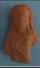
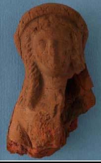
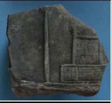
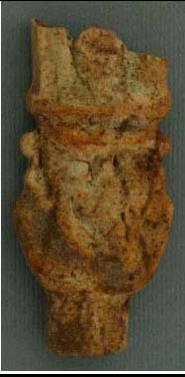
3 N6, Possible Harbor Area Two 5x5 meter (N6-1 and N6-2) (Figure 6) and two 2x2 m soundings (N6-3 and N6-4) were excavated in Grid N6. The purpose of N6-1 was to find how the buildings located during the magnetometry survey articulated with the possible harbor to the north. Two rooms were found, one in the SE corner and the other extending out from the SW corner, running parallel on an east to west line. Behind the rooms on the north wall was a hallway running along the backside of the rooms. Further excavation in the SE corner showed earlier phases of mudbrick walls. A shell deposit was found in the hallway portion at an elevation of m and a pottery fill in the NW corner at an elevation of -0.87m. N6-2 was opened adjacent to the western side of N6-1. The aim of opening this unit was to get a better look at the area immediately surrounding the harbor. The soil consisted of cemented clay with occasional inclusions of bone, shell, and ceramics. The western half of the unit consisted of sandy, clayey silt with moderate to frequent inclusions of ceramics, bone, and shell. A pottery fill covered the western half of the unit at an elevation of m. After the removal of this pottery fill, the soil changed to a silty clay. N6-3 and N6-4 were opened to search for clues of a paleo waterline that might be associated with a harbor. As predicted by the magnetometry study, no architectural features were found and the artifact assemblage appears consistent with a shoreline midden deposit. N7 Excavation Area N7 consisted of three 5x5 m units focused on phasing the architecture revealed during the magnetometry survey. N7-1, N7-2, and N7-3 exposed three phases of construction, with preliminary results putting all phases in the Ptolemaic period. Within a few centimeters of the surface a redbrick well was found. East of the well was a large mudbrick wall that appears to be part of a large casemate foundation. After excavating further down a deposit with several artifacts such as the alabaster Taweret figurine (SCA#25) were found. The second phase of construction was earlier than the casemate structure and consisted of a large wall. The third phase of construction is earlier than both of the others. The phasing of N6-2 is less clear, though features included the corner of the casemate foundation, mixed cultural debris including Bes representation ceramics and faience figurines including a Hathor Sistrum and Harpocrates. In the SW corner a large collapse of mud brick indicates a substantial leveling of the area followed by successive rebuilds of the walls. In this mudbrick collapse there were large inclusions of burnt limestone including two inscribed blocks (SCA#31), one with a king and god and the other with a structure with a possible nfr sign. The earliest phase is represented by an oval structure that is defined by an area of burning and an increased amount of pottery in the deposit. In N6-3, on the west side of the well, mudbrick walls as seen in the magnetometry were revealed. The fill from this section included numerous Ptolemaic vessels and fragments of Bes plaques (SCA#33). Most objects here and in the well showed evidence of burning and the phase appears to be terminated with a leveling and fill following the burning. A ballistae stone was also found in the burn layer. Ceramic Analysis During the 2010 field season at Tell Timai a total of 1,963kg of pottery were processed from 18 trenches. The result of processing the pottery (i.e., sorting, identifying and registering), 335.5kg were saved as diagnostic pieces consisting of rim sherds, bases, handles, and diagnostically significant body sherds. In total, the diagnostic sherds comprise about 17% of all ceramic materials processed during the 2010 season. Of the saved pottery, 254 individual vessels (represented by a range of intact vessels, multiple sherds of a single vessels, or individual sherds) were inventoried for more detailed analysis. The selection of vessels for inventory was made based on one of several possible factors: 1) the vessel was an example of a particular type that would be desirable to demonstrate that it is found at Tell Timai; 2) the vessel was preserved to 3
4 such an extent (intact or near intact) and so provides a useful study example of the type; or 3) the vessel belonged to an important stratigraphic context. The last feature was by far the most common reason for selecting inventoried items. RESULTS: Area O (the kilns) The earliest stratigraphic features exposed in Area O during the 2010 excavations may be associated with the initial construction and use of the kilns that define the area. Several features produced pottery that is distinctly different from all other excavated features that clearly date to the Hellenistic period. This pottery most likely belongs to the later phases of the Late Period, though detailed analysis will not occur until the 2011 excavation season. While the bulk of the early pottery is of local production, one piece of Attic Red Figure (TM , O ) provides possible evidence of the earliest occupation/use of Area O. The Attic sherd, probably from a krater, is decorated in a style of Red Figure that dates to the mid-fourth century BC. The sherd preserves a portion of a wing belonging to a Nike, below which is the brow and wispy hair of a male figure with a diadem accented with a series of white dots. 1 The Attic import provides evidence suggesting that the kilns in Area O are pre- Ptolemaic. Area N (destruction deposit) Excavations in Grid N produced a well-defined deposit of pottery that included intact, whole, and near complete vessels. The deposit was found in Unit N7-3 and identified as Feature 257. Of the sixty-four vessels or sherds inventoried from feature 257, many were burnt to a degree that suggested the burning event resulted in their deposition in the archaeological record. For this reason, the deposit has been interpreted as a destruction deposit associated with a fire. Further excavation in Area N revealed an extension of the destruction deposit located within the brick-lined well located in the southeast section of N7-1. The uppermost fill of the well (Feature 519) yielded a high density of pottery within the fill matrix that included whole and well-preserved vessels. Like the vessels from Feature 257, the vessels from the well were all burnt, suggesting they were part of the same destruction event. Two possibilities exist for the deposition of the vessels in the well: 1) the pots were dumped in the well after the destruction event in an effort to fill the well and put it out of commission; 2) the bowls, jars, and cooking vessels fell into the well during the destruction event. The possibility of the second scenario is strengthened by the recovery of whole vessels, broken into two or three large sherds, found together but with burning inside the breaks. This may indicate a continuation of the fire after the bowls reached their final resting place and broke. However, the deposit was recovered from the upper levels of the well, meaning the well was already filled with debris by the time the vessels entered their final context, presenting an argument for the first scenario. The character of the destruction deposit recovered from Unit N7-3 and the well in N7-1 is domestic, consisting of table vessels, cooking vessels, household utility vessels, and storage vessels. While the general typological characteristics of the deposit fit well within the expected parameters of domestic Hellenistic period ceramic assemblages, the richness and diversity of the single destruction deposit provides new and detailed evidence for the Hellenistic ceramic history of the eastern Nile delta specifically and the Lower Egypt in general. With the exceptions of numbers 1-4, all table vessels are of local production, made 1 Dating based on similar treatment of wings, decorated diadems, and wispy hair. See Moore 1997, nos. 524, 533, and
5 of local Nile Silt. It is probable that these vessels were produced at Tell Timai. The kilns excavated in Area O by the SCA and mapped by the University of Hawaii mission, may well have produced the bulk of the Tell Timai table vessels, but the absence of a ceramic waster dump makes positive identification so far impossible. Dating evidence for the deposit points to the first half of the second century BC. This date is derived by comparative typological analysis with ceramic remains from other sites in the Delta region and the eastern Mediterranean in general. The types of vessels that provide dating evidence include table, cooking, and utility vessels. Areas N and O One of the most significant contributions of the ceramic field analysis of summer 2010 was linking the last domestic phase of Grid N with the cessation of industrial activities in Grid O. A single large rim fragment from a large storage jar found in O6-18, Feature 344 joins several large fragments of the same storage jar found in N7-1, Feature 238. Upon further examination of the two contexts it was determined that the two were very similar in composition, consisting of high quantities of locally produced Hellenistic table vessels (incurved rim bowls and thickened rim saucers) and Hellenistic cooking vessels (cook pots, stew pots, and casseroles). Though another join between the two features could not be identified, it was evident that there were non-joining fragments of the same vessels shared between the two. Examination of the stratigraphy in O6-18 revealed that feature 344 was a small section of a remaining lens left unexcavated from previous SCA excavations. The stratigraphy indicates that this lens should be associated with the fill that covered the kilns located in Area O. That the larger fragments of the storage jar that joins Areas N and O was found in Area N suggests that its primary context was in N7-1. Thus, it appears that material from Area N was used to cover the kilns, putting them out of use. Our working hypothesis is that the destruction event that produced the destruction deposit in Area N7-3 and 1 led to a leveling of the damaged/destroyed domestic structures in the Area N. The structures, along with their contents were leveled off and much of the debris was used to cover the kilns located in Area O, ending the industrial use of the area. This clearance may well be connected to the construction of the mudbrick platform in Area M, the predecessor to the limestone platform built at the end of the Ptolemaic period. If this is the case, it is possible that the destruction event heralds a transformation of this portion of Hellenistic Tell Timai from an industrial (Area O) and domestic zone (area N) to a larger public space that leveled over the houses and covered up the industrial kilns, marked by the construction of a monumental mudbrick platform. Area M (the limestone platform) The 2010 excavations in Area M produced dating evidence for the construction of the limestone platform exposed in While no ceramic remains from sealed contexts associated with the construction of the platform provide clear, absolute dating evidence, much of what was recovered has characteristics that can be qualified as Late Hellenistic/Early Roman. Feature M , a foundation trench for the platform, produced a plainware bowl (fig.8.1), an Aswan ware jug base (fig.8.2), and a white-slipped jar (fig.8.3). The plainware bowl (fig.8.1) does not follow typical Hellenistic forms, but is reminiscent of standard Late Hellenistic/Early Roman productions, especially in the eastern sigillata tradition. The rounded, thickend rim is similar to Eastern Sigillata A (ESA) Atlante form 12 (ca. 40 BC-AD 10) and to Cypriot Sigillata Atlante form 10 (generally 1 st century AD). 2 2 ESA Atlante form 12 (Hayes 1985: 20, Tav.II.10); Cypriot Sigillata Atlante form 10 (Hayes 1985: 82, Tav.19.1). 5
6 Excavations from the 2009 season that exposed the limestone platform yielded sealed contexts from the packing material within the casemates of the structure. While little ceramic material was recovered, two pieces are identified as probable late 1 st century BC types. A small rim sherd of a semi-fine ware small bowl (fig.8.4) is reminiscent of Early Roman ceramic forms from the Italian sigillata tradition. 3 The fabric of the sherd from the casemate packing is not obviously Italian or of the general western sigillata tradition, but its production is not local, being of finer quality than the usual Nile silt productions in the Tell Timai region. However, its material characteristics are such that it may be a finer Egyptian imitation of the western form. The other Late Hellenistic/Early Roman diagnostic sherd from the 2009 excavations of the limestone structure is an Amphore Égyptienne Bitronconique 3 also referred to as Amphore Égyptienne 3, or AE 3 (fig.8.5) which is generally dated no earlier than the late 1 st century BC (the end of the Ptolemaic/beginning of the Roman periods). 4 The presence of AE 3 within the casemate packing of the limestone platform in Area M provides dating evidence for the construction of the casemates of no earlier than the very end of the Ptolemaic period, or perhaps the beginning of the Roman period. Preliminary phasing sequence for the University of Hawaii excavations The dated contexts presented in this report provide the framework for a preliminary phasing sequence of activities in the areas excavated at Tell Timai by the University of Hawaii from The sequence begins with the earliest recorded activities in the industrial zone in Area O, followed by the domestic occupation in Are N, then the clearance and covering up of both the industrial and domestic zones to make room for an open publics space, and ending with the construction of a large limestone platform at the end of the Ptolemaic/beginning of the Roman period. Phase Date Area Narrative Phase I 4 th -3 rd c. BC Area O Industrial installations built. Terminus post quem = mid-4 th c BC (Attic RF sherd) Phase II 3 rd -mid-2 nd c. BC Area N Domestic occupation. Earliest materials associated with domestic spaces include Gnathian Kantharoi of the mid-3 rd century BC. Phase III mid-2 nd c. BC Area N Destruction of domestic area and covering up of industrial zone. Destruction deposit provides dating evidence and material evidence for activities at the end of Phase II. Phase IV Late 1 st c BC Area M Construction of the limestone platform. 3 The form is similar to Haltern 7 (ca. 20 BC-AD15/20). 4 This type of amphora is also called an Amphore Égyptienne 3 (AE3). See Empereur and Picon 1998, 77. 6
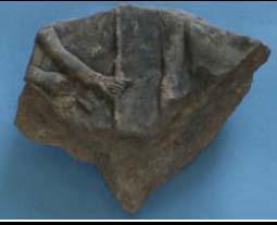
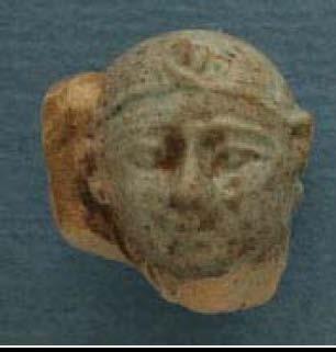
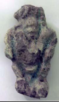
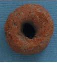
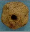
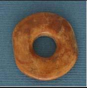
7 ITEMS CATALOGED AT TAFTISH SCA# Material Description Dimensions Period Condition Provenience 25 Alabaster N Taweret figurine H=82.5mm Ptolemaic Excellent W=30.9mm Base=17.3mm 26 Ceramic N Echinus Cup H=51.9mm Ptolemaic Very Good D=107.4mm 27 Ceramic W17 Surface Plainware Bowl, Fired Grey H=54.4mm Ptolemaic Very Good D=131.0mm -Early Roman 28 Terra Cotta N Tanagra Figure of a Woman H=77.6mm Ptolemaic Upper half W=45.2mm 29 Terra Cotta N Tanagra Figure of a Woman H=83.5mm Ptolemaic Split W=36.6mm 30 Terra Cotta N Tanagra Figure of a Woman H=61.3mm Ptolemaic Face only W=59.0mm 31 Limestone N Carved limestone with ankh, from structure, 2 pieces Ca. 120mm Ptolemaic 2 fragments from unknown structure 32 Ceramic N Figurine base with white slip H=21.2mm Ptolemaic Base only W=57.2mm 33 Ceramic N Bes figure plaque H=126.4mm Ptolemaic Upper body only W=66.4mm 34 Ceramic N Moulded flask with 2 faces H=46.7mm W=68.9mm Ptolemaic Upper portion only 35 Terra Cotta N Tanagra figure, woman H=53.6mm Ptolemaic Head ony, worn W=37.1mm 36 Faience N Figurine, possible hathor H=59.4mm Ptolemaic Fair W=28.7mm 37 Faience N Figurine, Harpocrates, hand of Isis on head H=14.0mm D=11.3mm Ptolemaic Head only, excellent 38 Faience N Figurine, possible Bes H=57.8mm Ptolemaic Fair W=34.1mm 39 Bone N Spatula or awl L=83.5mm Ptolemaic Good W=9.9mm 40 Ceramic N Bead D=23.0mm Ptolemaic Good W=15.6mm 41 Ceramic O Bead W=16.9mm Ptolemaic Good D=18.9mm 42 Ivory C19-Surface Flat bead D=21.4mm W=4.3mm Ptolemaic Excellent 7


8 a 31b


9


10 Figure 1. Map of Tell Timai showing 50 m grid primary area of work in Figure 2: Map of north area showing magnetometry data and units mapped and worked in Figure 3. Units N7-1, N7-2,N7-3 showing a well and mudbrick structures. 10


11 Figure 2. Map of north area of tell showing results of magnetometry geophysical survey. Figure 3. Locations of cores drilled in the 2010 season (map: J. Trampier) 11


12 3 2 1 Figure 4. Features mapped in the P6 and P7 grid square areas. Figure 5. Kilns in Unit O
By : K. Blouin, Th. Faucher, N. Hudson, M. Kenawi, A. Kirby, R. Mairs, G. Marchiori, M. Van Peene
 THMUIS, A NEW LAND IN THE EASTERN NILE DELTA FIRST CANADIAN MISSION AT THMUIS By : K. Blouin, Th. Faucher, N. Hudson, M. Kenawi, A. Kirby, R. Mairs, G. Marchiori, M. Van Peene The first Canadian Mission
ANNUAL REPORT: ANCIENT METHONE ARCHAEOLOGICAL PROJECT 2014 FIELD SCHOOL
 ANNUAL REPORT: ANCIENT METHONE ARCHAEOLOGICAL PROJECT 2014 FIELD SCHOOL Director(s): Co- Director(s): Professor Sarah Morris, Cotsen Institute of Archaeology, UCLA John K. Papadopoulos, Cotsen Institute
oi.uchicago.edu TALL-E BAKUN
 TALL-E BAKUN ABBAS ALIZADEH After I returned in September 1991 to Chicago from Cambridge, Massachusetts, I began preparing for publication the results of 1937 season of excavations at Tall-e Bakun, one
Jneneh in the Upper Wadi az-zarqa, in North Central Jordan, First Season 2011.
 Jneneh in the Upper Wadi az-zarqa, in North Central Jordan, First Season 2011. Khaled Douglas Jneneh is located in the north-western periphery of the city of Zarqa (grid ref. 250.88E 165.25N), in North
The Greek-Swedish-Danish Excavations at Kastelli, Khania 2010 a short report
 The Greek-Swedish-Danish Excavations at Kastelli, Khania 2010 a short report During six weeks from 19 July to 27 August the Greek-Swedish-Danish Excavations continued work in the Ag. Aikaterini Square
In 2014 excavations at Gournia took place in the area of the palace, on the acropolis, and along the northern edge of the town (Fig. 1).
.") Gournia: 2014 Excavation In 2014 excavations at Gournia took place in the area of the palace, on the acropolis, and along the northern edge of the town (Fig. 1). In Room 18 of the palace, Room A, lined
Gournia: 2014 Excavation In 2014 excavations at Gournia took place in the area of the palace, on the acropolis, and along the northern edge of the town (Fig. 1). In Room 18 of the palace, Room A, lined
IKLAINA ARCHAEOLOGICAL PROJECT 2016 FIELD REPORT Michael B. Cosmopoulos
 IKLAINA ARCHAEOLOGICAL PROJECT 2016 FIELD REPORT Michael B. Cosmopoulos Introduction The overarching objective of the Iklaina project is to test existing hierarchical models of state formation in Greece
New Studies in the City of David The Excavations
 The 2013-2014 Excavations Israel Antiquities Authority The intensive archaeological work on the city of David hill during the period covered in this article has continued in previously excavated areas
Trench 91 revealed that the cobbled court extends further to the north.
 Report on the 2013 Gournia Excavations The 2013 excavations at Gournia were conducted June 17 July 26 under the aegis of the American School of Classical Studies at Athens and the supervision of the KD
THE EL-QITAK PROJECT. oi.uchicago.edu
 oi.uchicago.edu THE EL-QITAK PROJECT T H O M A S - L - M C C L E L L A N T he 1987 season at el-qitar ran from May 2 t o July 29th and marked the last major season of excavation there because the site
picture at 50mm from top frame The British Museum Expedition to Kom Firin
 picture at 50mm from top frame The British Museum Expedition to Kom Firin Report on the 2009 season The British Museum has been working at Kom Firin, a large settlement site in Beheira, since 2002 (fig.
TH E FIRST SEASON of investigations at the
 QUSEIR AL-QADIM Janet H. Johnson & Donald Whitcomb TH E FIRST SEASON of investigations at the ancient port of Quseir al-qadim on the Red Sea in Egypt took place in winter, 1978; the investigations were
Archaeologists for Hire: An In-Class Activity
 Archaeologists for Hire: An In-Class Activity Beyond Grades: Capturing Authentic Learning Conference Welcome to the Marveloso Valley, a fictional valley on the central coast of Peru. Over the decades,
Gorse Stacks, Bus Interchange Excavations Interim Note-01
 Gorse Stacks, Bus Interchange Excavations 2015 Prepared for: Cheshire West & Chester Council Interim Note-01 1 Introduction & Summary Background Since c. 2000 investigations associated with redevelopment
ARCHAEOLOGICAL INVESTIGATIONS IN GUADALUPE, NORTHEAST HONDURAS
 ARCHAEOLOGICAL INVESTIGATIONS IN GUADALUPE, NORTHEAST HONDURAS Markus Reindel, Franziska Fecher and Peter Fux Archaeological investigations in Honduras have focused on the western, Mesoamerican part of
IMTO Italian Mission to Oman University of Pisa 2011B PRELIMINARY REPORT (OCTOBER-DECEMBER 2011)
") IMTO Italian Mission to Oman University of Pisa 2011B PRELIMINARY REPORT (OCTOBER-DECEMBER 2011) The 2011B research campaign took place in the area around Salut from October, 19 th, to December, 16 th.
IMTO Italian Mission to Oman University of Pisa 2011B PRELIMINARY REPORT (OCTOBER-DECEMBER 2011) The 2011B research campaign took place in the area around Salut from October, 19 th, to December, 16 th.
Azoria 2004 B700 Final Trench Report RQC
 Azoria 2004 B700 Final Trench Report RQC B700 is a room -2.5m by 4.5m, bounded by wall B711 to north, wall B703 to east, wall B706 to south, and wall B717 to west. B700 is an Archaic storeroom with an
Following the initial soil strip archaeology is sprayed up prior to planning and excavation
 Barton Quarry & Archaeology Over the past half century quarries have been increasingly highlighted as important sources of information for geologists, palaeontologists and archaeologists, both through
218 R. S. BORAAS AND S. H. HORN
 were able to show a sequence of ceramic corpora much more fully representative than those available from the occupation surfaces and structures higher on the mound. This ceramic series obtained from D.
The Harbour of Naukratis, 'Mistress of Ships'
 The Harbour of Naukratis, 'Mistress of Ships' The British Museum Naukratis Project s third fieldwork season at Kom Ge if, Egypt (Beheira MSA site no.100253) April-May 2014 Ross Thomas and Alexandra Villing,
An archaeological evaluation at 19 Beverley Road, Colchester, Essex February 2003
 An archaeological evaluation at 19 Beverley Road, Colchester, Essex February 2003 report prepared by Carl Crossan on behalf of Mr G and Mrs H Prince NGR: TL 98655 24844 CAT project ref.: 03/2d Planning
REPORT ON THE 2004 FIELDWORK SEASON OF THE UNIVERSITY OF CALIFORNIA BERKELEY AT THE ARCHAEOLOGICAL SITE OF EL-HIBEH, BENI-SUEF GOVERNORATE
 REPORT ON THE 2004 FIELDWORK SEASON OF THE UNIVERSITY OF CALIFORNIA BERKELEY AT THE ARCHAEOLOGICAL SITE OF EL-HIBEH, BENI-SUEF GOVERNORATE By Carol A. Redmount, Project Director The archaeological site
Archaeological Investigations Project South East Region SOUTHAMPTON 2/842 (C.80.C004) SU
 SU") SOUTHAMPTON City of Southampton 2/842 (C.80.C004) SU 4382 1336 125 BITTERNE ROAD WEST, SOUTHAMPTON Report on the Archaeological Evaluation Excavation at 125 Bitterne Road West, Southampton Russel, A. D
SOUTHAMPTON City of Southampton 2/842 (C.80.C004) SU 4382 1336 125 BITTERNE ROAD WEST, SOUTHAMPTON Report on the Archaeological Evaluation Excavation at 125 Bitterne Road West, Southampton Russel, A. D
Chapter 4 Research on Block 13, Lots 3 and 4
 Chapter 4 Research on Block 13, Lots 3 and 4 George Calfas History Block 13, Lots 3 and 4 Oral history and the written record Squire McWorter acquired the deed to Block 13, Lots 3 and 4 in 1854. Squire
AN ARCHAEOLOGICAL ASSESSMENT OF BOERNE CITY PARK, KENDALL COUNTY, TEXAS. Thomas C. Kelly and Thomas R. Hester
 AN ARCHAEOLOGICAL ASSESSMENT OF BOERNE CITY PARK, KENDALL COUNTY, TEXAS Thomas C. Kelly and Thomas R. Hester Center for Archaeological Research The University of Texas at San Antonio Archaeological Survey
First announcement concerning the results of the 2005 exploratory season at Tel Kabri
 First announcement concerning the results of the 2005 exploratory season at Tel Kabri Assaf Yasur-Landau Tel Aviv University (assafy@post.tau.ac.il) Eric H. Cline The George Washington University (ehcline@gwu.edu)
IMTO Italian Mission to Oman. University of Pisa SUMHURAM. Preliminary Report. February March 2016 (SUM16A)
") IMTO Italian Mission to Oman University of Pisa SUMHURAM Preliminary Report February March 2016 (SUM16A) PRELIMINARY REPORT (SUM16A) February March 2016 The first IMTO s campaign of 2016 (SUM16A), under
IMTO Italian Mission to Oman University of Pisa SUMHURAM Preliminary Report February March 2016 (SUM16A) PRELIMINARY REPORT (SUM16A) February March 2016 The first IMTO s campaign of 2016 (SUM16A), under
The importance of Jerusalem for the study of Near Eastern history and. archaeology and for the study of the Biblical text (both old and new) cannot
 cannot") Setting the Clock in the City of David: Establishing a Radiocarbon Chronology for Jerusalem's Archaeology in Proto-historical and Historical Times Yuval Gadot, Johana Regev, Helena Roth and Elissabeta
Setting the Clock in the City of David: Establishing a Radiocarbon Chronology for Jerusalem's Archaeology in Proto-historical and Historical Times Yuval Gadot, Johana Regev, Helena Roth and Elissabeta
Investigations at Jackdaw Crag Field, Boston Spa, SE , in by Boston Spa Archaeology and Heritage Group
 0 Investigations at Jackdaw Crag Field, Boston Spa, SE 42304632, in 2006-7 by Boston Spa Archaeology and Heritage Group www.bostonspaheritage.co.uk Preface and Summary This report records the results of
Excavation in Area G: squares m/14-15, new building BG1 (trench supervisor: Cleto Carbonara)
") Excavation in Area G: squares m/14-15, new building BG1 (trench supervisor: Cleto Carbonara) The excavation in the Area G started in the 1 st October has two main purposes: To understand the real extension
Excavation in Area G: squares m/14-15, new building BG1 (trench supervisor: Cleto Carbonara) The excavation in the Area G started in the 1 st October has two main purposes: To understand the real extension
Preliminary Report on the work of the Egyptian-German Mission at Matariya / Heliopolis in Autumn 2005 *
 Preliminary Report on the work of the Egyptian-German Mission at Matariya / Heliopolis in Autumn 2005 * by Mohammed Abd el-gelil, Reda Suleiman, Gamal Faris and Dietrich Raue Fig. 1: Temple precinct of
Jane C. Waldbaum Archaeological Field School Scholarship - Report.
 Jane C. Waldbaum Archaeological Field School Scholarship - Report. Eastern Boeotia Archaeological Project, 2017 Novella Nicchitta Figure 1 EBAP's team for 2017 This year I had the pleasure of participating
ROUKEN GLEN: BANDSTAND 2015 DATA STRUCTURE REPORT
 ROUKEN GLEN: BANDSTAND 2015 DATA STRUCTURE REPORT Author (s) Ian Hill Editors Report Date June 2015 Working Partners Funders Phil Richardson East Renfrewshire Council East Renfrewshire Council, Heritage
Department of Tourism, Culture and Recreation Provincial Archaeology Office 2012 Archaeology Review February 2013 Volume 11
 Department of Tourism, Culture and Recreation Provincial Archaeology Office 2012 Archaeology Review February 2013 Volume 11 Area 14 of FjCa-14 in Sheshatshiu, portion of feature in southeast corner of
Draft Report. 7. Excavations in the temenos gateway, Area (TG5) Author - D. A. Welsby Period 1-2. Period 1. Period 2. Derek A.
 Author - D. A. Welsby Period 1-2. Period 1. Period 2. Derek A.") 7. Excavations in the temenos gateway, Area (TG5) Derek A. Welsby When Griffith excavated the temples at Kawa in 1929-31, work followed by that of Macadam and Kirwan in the winter of 1935-6, the temenos
7. Excavations in the temenos gateway, Area (TG5) Derek A. Welsby When Griffith excavated the temples at Kawa in 1929-31, work followed by that of Macadam and Kirwan in the winter of 1935-6, the temenos
220 NOTES AND NEWS REFERENCES
 220 NOTES AND NEWS pottery uncovered in each building, the inscription (found during the 2008 season), the seal and various metal objects. The site functioned as a rich urban centre. One would expect mention
aiton.new 1/4/04 3:48 AM Page 2
 aiton.new 1/4/04 3:48 AM Page 2 Below: An aerial view of area A of the excavations. A massive square building that appears to be a fortress was discovered in this area at the top of the tell. aiton.new
IKLAINA ARCHAEOLOGICAL PROJECT 2012 FIELD REPORT
 IKLAINA ARCHAEOLOGICAL PROJECT 2012 FIELD REPORT Michael B. Cosmopoulos The sixth season of the Iklaina Archaeological Project was conducted for six weeks in June and July 2012. Τhe project is conducted
The Sanctuary of Athena Alea at Tegea: Recent Excavations in the Northern Area. Results and Problems
 The Sanctuary of Athena Alea at Tegea: Recent Excavations in the Northern Area. Results and Problems Chiara Tarditi The excavations in the northern area of the sanctuary of Athena Alea at Tegea, organized
E X C A V A T I O N O F T H E E A R L Y I R O N A G E S E T T L E M E N T A T A Z O R I A By Donald C. Haggis and Margaret S. Mook
 E X C A V A T I O N O F T H E E A R L Y I R O N A G E S E T T L E M E N T A T A Z O R I A By Donald C. Haggis and Margaret S. Mook Figure 1. B3500: Sondage from the east, showing Archaic cobble fill and
CARLUNGIE EARTH HOUSE
 Property in Care (PIC) ID: PIC015 Designations: Scheduled Monument (SM90059) Taken into State care: 1953 (Guardianship) Last reviewed: 2004 HISTORIC ENVIRONMENT SCOTLAND STATEMENT OF SIGNIFICANCE CARLUNGIE
Cholesbury New House, Parrots Lane, Cholesbury, Buckinghamshire
 Cholesbury New House, Parrots Lane, Cholesbury, Buckinghamshire An Archaeological Watching Brief For Mr Martin Wood by Sean Wallis Thames Valley Archaeological Services Ltd Site Code PLC 06/135 March 2007
The Italian Archaeological Mission in Sudan Ca Foscari University of Venice
 The Italian Archaeological Mission in Sudan Ca Foscari University of Venice Karima (Sudan) November-December 2012 The 2012 season of the Italian Archaeological Mission at Jebel Barkal was carried out between
archeological site LOS MILLARES
 archeological site LOS MILLARES Aerial view of the plain of Los Millares between the Rambla de Huéchar and the River Andarax The archaeological site of Los Millares is located in the township of Santa
oi.uchicago.edu ARCHEOLOGY
 ARCHEOLOGY Janet H. Johnson and Donald Whitcomb Quseir al-qadim The small port of Quseir al-qadim, Egypt, is situated on the north bank of the Wadi Quseir al-qadim where the wadi meets the Red Sea; it
The EXPLORERS CLUB. Report of Expedition. Xlendi Project Season Supported By AURORA TRUST and HERITAGE MALTA FLAG # 97
 The EXPLORERS CLUB Report of Expedition FLAG # 97 Xlendi Project 2007 Season Supported By AURORA TRUST and HERITAGE MALTA Craig Mullen Ian G. Koblick Introduction Explorer s Club Flag number 97 was issued
Report on the excavations on the site Novopokrovskoe II in V. Kol'chenko, F. Rott
 Report on the excavations on the site Novopokrovskoe II in 2016 V. Kol'chenko, F. Rott In 2016 the Novopokrovskiy archeological group of the Institute of History and Heritage of the National Academy of
As both one of the few substantially preserved pharaonic Egyptian. expulsion, the site of Deir el-ballas is of great archaeological and historic
 The 2017 Season at Deir el-ballas Peter Lacovara As both one of the few substantially preserved pharaonic Egyptian settlements as well as the forward capital for the Theban kings during the Hyksos expulsion,
A FIELDWALKING PROJECT AT HOLLINGBURY, BRIGHTON. by JOHN FUNNELL
 Introduction A FIELDWALKING PROJECT AT HOLLINGBURY, BRIGHTON by JOHN FUNNELL Members of the Brighton and Hove Archaeological Society walked the field at Hollingbury during the months of December 1991 and
The Tel Burna Archaeological Project Report on the First Season of Excavation, 2010
 The Tel Burna Archaeological Project Report on the First Season of Excavation, 2010 By Itzick Shai and Joe Uziel Albright Institute for Archaeological Research Jerusalem, Israel April 2011 The site of
Amarna Workers Village
 Amarna Workers Village The Egyptian city of Amarna was the pet building project of the pharaoh Akhenaten, who oversaw construction of his new capital between 1346 and 1341 BCE. The city was largely abandoned
IKLAINA ARCHAEOLOGICAL PROJECT 2015 FIELD REPORT Michael B. Cosmopoulos
 IKLAINA ARCHAEOLOGICAL PROJECT 2015 FIELD REPORT Michael B. Cosmopoulos The 2015 season of the Iklaina project took place from June 1 to July 7. The project is conducted under the auspices of the Athens
Prof. William R. Caraher, Prof. R. Scott Moore, and Prof. David K. Pettegrew
 The Pyla-Koutsopetria Archaeological Project A Third Preliminary Report Prof. William R. Caraher, Prof. R. Scott Moore, and Prof. David K. Pettegrew Delivered at the 24th Annual CAARI Workshop 24 June
Plates. Kom Firin I 193. Plate 96 View of the southwestern part of Kom Firin, looking west-southwest.
 Plates Plate 96 View of the southwestern part of Kom Firin, looking west-southwest. Plate 97 Ramesside temple: wall 0157 and clean sand 0189 (TG), view to north. Plate 98 Ramesside temple: wall 0135 (TD),
III. THE EARLY HELLADIC POTTERY FROM THE MASTOS IN THE BERBATI VALLEY, ARGOLID
 III. THE EARLY HELLADIC POTTERY FROM THE MASTOS IN THE BERBATI VALLEY, ARGOLID by JEANNETTE FORSÉN The Swedish investigations of the hillock Mastos in the western part of the Berbati valley, ca. 3 km south
Street Sweeper Dump Site, RAF Lakenheath ERL 160
 ARCHAEOLOGICAL MONITORING REPORT Street Sweeper Dump Site, RAF Lakenheath ERL 160 A REPORT ON THE ARCHAEOLOGICAL MONITORING, 2006 (Planning app. no. F/2006/0021/GOV) Jo Caruth Field Team Suffolk C.C. Archaeological
Pella in Jordan Early Bronze Age Fortifications, a Late Bronze Age Palace and a Hellenistic Villa. by Stephen Bourke Introduction
 The Near Eastern Archæology Foundation BULLETIN NUMBER 55 February 2012 Pella in Jordan 2011 Early Bronze Age Fortifications, a Late Bronze Age Palace and a Hellenistic Villa by Stephen Bourke Introduction
4. Bronze Age Ballybrowney, County Cork Eamonn Cotter
 4. Bronze Age Ballybrowney, County Cork Eamonn Cotter Illus. 1 Location map of the excavated features at Ballybrowney Lower (Archaeological Consultancy Services Ltd, based on the Ordnance Survey Ireland
Provincial Archaeology Office Annual Review
 2017 Provincial Archaeology Office Annual Review Provincial Archaeology Office Department of Tourism, Culture, Industry and Innovation Government of Newfoundland and Labrador March 2018 Volume 16 A brief
Cetamura Results Prior to 2000
 Cetamura Results Prior to 2000 Excavations at the hilltop of Cetamura del Chianti (695m above sea level) near Siena by Florida State University have unearthed a habitation with a long and diverse history,
B 1200: The Napatan palace and the Aspelta throne room.
 B 1200: The Napatan palace and the Aspelta throne room. The labyrinthine mud brick walls southwest of B 800 are the remains of the Napatan palace, designated "B 1200," at Jebel Barkal (fig. 1). Until now
Discover the archaeology of the best Egyptian and Classic Museums in Berlin & Dig in the Roman City of Sanisera (Menorca, Spain)
") Course 044 Discover the archaeology of the best Egyptian and Classic Museums in Berlin & Dig in the Roman City of Sanisera (Menorca, Spain) 1. General Information This program, which has been scheduled
Course 044 Discover the archaeology of the best Egyptian and Classic Museums in Berlin & Dig in the Roman City of Sanisera (Menorca, Spain) 1. General Information This program, which has been scheduled
Preliminary report on the 2013 season at Plakari
 Preliminary report on the 2013 season at Plakari Jan Paul Crielaard the 2013 excavations During the 2013 field season (8 July 5 August), excavations were continued on the southern slope of Terrace 2 (Trench
Aylesbury Masonic Hall, Ripon Street, Aylesbury, Buckinghamshire
 Aylesbury Masonic Hall, Ripon Street, Aylesbury, Buckinghamshire An Archaeological Recording Action for Wakefield Building Services by Andrew Mundin Thames Valley Archaeological Services Ltd Site Code
Florence House, High Street, Hurley, Berkshire
 Florence House, High Street, Hurley, Berkshire An Archaeological Watching Brief For Mr Michael Waterhouse by Jo Pine Thames Valley Archaeological Services Ltd Site Code FHH04/52 May 2004 Summary Site name:
Henderson Mess, RAF Halton, Buckinghamshire
 Henderson Mess, RAF Halton, Buckinghamshire An archaeological watching brief for Stepnell Ltd by Stephen Hammond Thames Valley Archaeological Services Ltd Site Code RHA03/85 October 2003 Summary Site name:
Çatalhöyük 2015 Archive Report by members of the Çatalhöyük Research Project
 Çatalhöyük 2015 Archive Report by members of the Çatalhöyük Research Project Chapter 4 Excavations in the TPC Area Arkadiusz Marciniak, Patrycja Filipowicz, Jędrzej Hordecki, Paul Eklöv Pettersson Introduction
Antinoupolis. Ongoing Destruction. Pre-2006 crops. Modern cemetery covering. ancient cemetery. Antinoupolis, ancient city. North cemetery (ancient).
.") Antinoupolis Ongoing Destruction Ongoing Destruction North cemetery (ancient). Pre-2006 crops Modern cemetery covering ancient cemetery. Antinoupolis, ancient city. Modern village of el Sheikh Abada Nile
Antinoupolis Ongoing Destruction Ongoing Destruction North cemetery (ancient). Pre-2006 crops Modern cemetery covering ancient cemetery. Antinoupolis, ancient city. Modern village of el Sheikh Abada Nile
CAMEROON. Overview. Selected Research Results. The Central Courtyard Area (Unit 1)
") CAMEROON Research at DGB-1, Northern Cameroon, 2008 Scott MacEachern, Joseph-Marie Datouang Djoussou and Rébecca Janson Scott MacEachern Department of Sociology and Anthropology Bowdoin College Brunswick,
CAMEROON Research at DGB-1, Northern Cameroon, 2008 Scott MacEachern, Joseph-Marie Datouang Djoussou and Rébecca Janson Scott MacEachern Department of Sociology and Anthropology Bowdoin College Brunswick,
BROOKLYN COLLEGE EXCAVATIONS AT THE NEW UTRECHT REFORMED CHURCH
 BROOKLYN COLLEGE EXCAVATIONS AT THE NEW UTRECHT REFORMED CHURCH SUMMER 2002 The New Utrecht Reformed Church is the fourth oldest church in Brooklyn. Founded in 1677, in the heart of the Dutch town of New
An archaeological excavation at 193 High Street, Kelvedon, Essex September 2009
 An archaeological excavation at 193 High Street, Kelvedon, Essex September 2009 report prepared by Ben Holloway and Howard Brooks on behalf of Marden Homes CAT project ref.: 09/4g NGR: TL 8631 1913 (c)
TELL ES-SWEYHAT EXPEDITION TO SYRIA
 TELL ES-SWEYHAT EXPEDITION TO SYRIA THOMAS A. HOLLAND The fifth season of archaeological excavations was conducted during October and November 1991 at the Early Bronze Age site of Tell Es-Sweyhat, which
Wessex Archaeology. Little Stubbings, West Amesbury, Salisbury, Wiltshire. Archaeological Watching Brief. Ref:
 Wessex Archaeology Little Stubbings, West Amesbury, Salisbury, Wiltshire Ref: 63280.02 March 2007 LITTLE STUBBINGS, WEST AMESBURY, NR SALISBURY, WILTSHIRE ARCHAEOLOGICAL WATCHING BRIEF Prepared for: P
REEVALUATING THE MIMBRES COLLAPSE AT THE BLACK MOUNTAIN SITE
 REEVALUATING THE MIMBRES COLLAPSE AT THE BLACK MOUNTAIN SITE Kathryn J. Putsavage Southwestern New Mexico is famous for its pottery, the remarkable black-on-white bowls of the Mimbres phase (A.D. 1000-1150)
BRAP BEAT. Results of Week 2 By Kent Bramlett
 BRAP BEAT Results of Week 2 By Kent Bramlett The second week has produced real progress and advancement of our understanding in each of the three areas. The Qasr team removed the 1st century AD pavement
An archaeological evaluation at 14 Vineyard Street, Colchester, Essex March 2006
 An archaeological evaluation at 14 Vineyard Street, Colchester, Essex March 2006 report prepared by Ben Holloway commissioned by Colchester Borough Council CAT project code: 06/4b Colchester Museums accession
Dates of Survey: July 26 th -August 16 th, 2007
 Tell Timai Archaeological Survey Professor Robert J. Littman, University of Hawaii Professor Jay Silverstein, University of Hawaii under the direction of Dr. Donald P. Redford, Penn State University Dates
EXCAVATIONS AT AIXONIDAI HALAI VOULA FIELD SCHOOL
 EXCAVIONS HALAI J A N U A R Y 8-2 7, 2 0 1 8 I N S T R U C T O R : D R. J O H N K A R A V A S VOULA FIELD SCHOOL EXCAVIONS HALAI COURSE DETAILS Dates : January Students who have a serious interest in archaeology
Shaded relief map of Egypt
 PHYSICAL LANDSCAPES OF ANCIENT EGYPT EGYPT: GIFT OF THE NILE - HERODOTUS MODIS (Moderate Resolution Imaging Spectroradiometer) image of the Nile River Valley, from NASA. Dr. John Paul Stimac Honors College
ANNA MORPURGO-DAVIES GERALD CADOGAN A SECOND LINEAR A TABLET FROM PYRGOS
 ANNA MORPURGO-DAVIES GERALD CADOGAN A SECOND LINEAR A TABLET FROM PYRGOS In May 1975 a second broken Linear A tablet was found during study of the pottery from the Minoan country house at Pyrgos near the
ARDESTIE EARTH HOUSE HISTORIC ENVIRONMENT SCOTLAND STATEMENT OF SIGNIFICANCE. Property in Care no: 24
 Property in Care no: 24 Designations: Scheduled Monument (SM90021) Taken into State care: 1953 (Guardianship) Last reviewed: 2004 HISTORIC ENVIRONMENT SCOTLAND STATEMENT OF SIGNIFICANCE ARDESTIE EARTH
Fieldwork Report for the Society for the Promotion of Roman Studies
 Fieldwork Report for the Society for the Promotion of Roman Studies A geophysical survey of the Roman villa at Santa Maria della Strada Matrice (Campobasso, Italy) Paul Roberts ¹, Dominic Rathbone ², Stephen
Archaeological Investigations Project Yorkshire & Humberside Region NORTH YORKSHIRE 2/1113 (C.36.J002) SD
 SD") NORTH YORKSHIRE Craven 2/1113 (C.36.J002) SD 93607800 CRAY BECK, BUCKDEN, UPPER WHARFEDALE Cray Beck, The Archaeological Investigation of a Stone Feature Archetype Wensleydale : ArcheType Archaeological
NORTH YORKSHIRE Craven 2/1113 (C.36.J002) SD 93607800 CRAY BECK, BUCKDEN, UPPER WHARFEDALE Cray Beck, The Archaeological Investigation of a Stone Feature Archetype Wensleydale : ArcheType Archaeological
THE HELLENISTIC TRANSPORT AMPHORAS FROM THE EXCAVATION AT THE HARBOUR OF PHALASARNA:
 THE HELLENISTIC TRANSPORT AMPHORAS FROM THE EXCAVATION AT THE HARBOUR OF PHALASARNA: new data for the study of the economy of Crete before the Roman conquest. Final Report Dr. Pasquale Valle A brief history
Labraunda Preliminary report
 Labraunda 2012. Preliminary report The excavations at Labraunda this year were very successful and lasted for eight weeks. Our main new discovery is obviously the gold coin from Philip II discovered in
Archaeological Evaluation Report
 Holywell House Osney Mead Oxford o a November 2007 Client: Knowles and Son Issue N o : 1 OA Job N o : 3826 Planning Ref N o : 02/01800/FUL NGR: SP 502 055 Client Name: Knowles and Son Client Ref No: Document
BRONZE AGE FIELD SYSTEM AT SOUTHAMPTON AIRPORT
 Proc. Hampshire Field Club Archaeol. Soc. 65, 2010, 1-6 (Hampshire Studies 2010) BRONZE AGE FIELD SYSTEM AT SOUTHAMPTON AIRPORT By J SULIKOWSKA With contributions by LORRAINE MEPHAM and CHRIS J STEVENS
PRELIMINARY REPORT ON THE FIRST SEASON OF THE TELL NABASHA PROJECT, AUTUMN 2015
 PRELIMINARY REPORT ON THE FIRST SEASON OF THE TELL NABASHA PROJECT, AUTUMN 2015 Nicky Nielsen, Valentina Gasperini and Mandy Mamedow 1 Abstract: A team from the University of Liverpool undertook the first
Rituals of the Past. Rosenfeld, Silvana, Bautista, Stefanie. Published by University Press of Colorado. For additional information about this book
 Rituals of the Past Rosenfeld, Silvana, Bautista, Stefanie Published by University Press of Colorado Rosenfeld, Silvana & Bautista, Stefanie. Rituals of the Past: Prehispanic and Colonial Case Studies
Architectural Analysis in Western Palenque
 Architectural Analysis in Western Palenque James Eckhardt and Heather Hurst During the 1999 season of the Palenque Mapping Project the team mapped the western portion of the site of Palenque. This paper
Unlocking Our Coastal Heritage Project: Crane Castle Promontory Fort, Illogan, Cornwall
 Unlocking Our Coastal Heritage Project: Crane Castle Promontory Fort, Illogan, Cornwall As part of a wider project funded by the Rural Development Programme for England (RDPE) and administered through
An archaeological fieldwalking evaluation at Tile House Farm, Great Horkesley, Essex July-September 2005
 An archaeological fieldwalking evaluation at Tile House Farm, Great Horkesley, Essex commissioned by ADP Chartered Architects on behalf of The Ingleton Properties Ltd and Mersea Homes CAT project code:
Excavations at El Palenque, San Martín Tilcajete: A Late Formative Subregional Center in the Oaxaca Valley, México
 FAMSI 2000: Elsa M. Redmond Excavations at El Palenque, San Martín Tilcajete: A Late Formative Subregional Center in the Oaxaca Valley, México Research Year: 1999 Culture: Zapotec Chronology: Late Pre-Classic
AREA A. BASTIAAN VAN ELDEREN Calvin Theological Seminary, Grand Rapids, Michigan
 AREA A BASTIAAN VAN ELDEREN Calvin Theological Seminary, Grand Rapids, Michigan During the 1968 and 1971 seasons six Squares were excavated in Area A, all but one (A.6) to bedrock.' Approximately threefourths
Dr. Dimitris P. Drakoulis THE REGIONAL ORGANIZATION OF THE EASTERN ROMAN EMPIRE IN THE EARLY BYZANTINE PERIOD (4TH-6TH CENTURY A.D.
 Dr. Dimitris P. Drakoulis THE REGIONAL ORGANIZATION OF THE EASTERN ROMAN EMPIRE IN THE EARLY BYZANTINE PERIOD (4TH-6TH CENTURY A.D.) ENGLISH SUMMARY The purpose of this doctoral dissertation is to contribute
The$Cisterns$of$No.on$ $ Angela$Commito$
 The$Cisterns$of$No.on$ $ Angela$Commito$ Aerial$view$of$No.on,$looking$northeast$ View$looking$up$cistern$sha
Discover archaeology and the ancient art in The Louvre Museum (Paris, France) & Dig in the Roman City of Sanisera (Menorca, Spain)
 & Dig in the Roman City of Sanisera (Menorca, Spain)") Course 030 Discover archaeology and the ancient art in The Louvre Museum (Paris, France) & Dig in the Roman City of Sanisera (Menorca, Spain) 1. General Information This program, which has been scheduled
Course 030 Discover archaeology and the ancient art in The Louvre Museum (Paris, France) & Dig in the Roman City of Sanisera (Menorca, Spain) 1. General Information This program, which has been scheduled
[UNEDITED DRAFT-INTERNAL USE ONLY] Steven M. Ortiz and Samuel R. Wolff
![[UNEDITED DRAFT-INTERNAL USE ONLY] Steven M. Ortiz and Samuel R. Wolff](/thumbs/96/128776431.jpg "[UNEDITED DRAFT-INTERNAL USE ONLY] Steven M. Ortiz and Samuel R. Wolff") Tel Gezer G-56/2007 p. 1 Tel Gezer, 2007 Excavation Summary Report [UNEDITED DRAFT-INTERNAL USE ONLY] Steven M. Ortiz and Samuel R. Wolff Introduction The second season of the renewed excavations of Tel
Tel Gezer G-56/2007 p. 1 Tel Gezer, 2007 Excavation Summary Report [UNEDITED DRAFT-INTERNAL USE ONLY] Steven M. Ortiz and Samuel R. Wolff Introduction The second season of the renewed excavations of Tel
An archaeological watching brief at the Sixth Form College, North Hill, Colchester, Essex
 An archaeological watching brief at the Sixth Form College, North Hill, Colchester, Essex July 2001 on behalf of Colchester Borough Council CAT project ref.: 01/7B Colchester Museum accession code: 2001.126
Discover archaeology and the ancient art in The British Museum (London, England) & Dig in the Roman City of Sanisera (Menorca, Spain)
 & Dig in the Roman City of Sanisera (Menorca, Spain)") Course 033 Discover archaeology and the ancient art in The British Museum (London, England) & Dig in the Roman City of Sanisera (Menorca, Spain) 1. General Information This program, which has been scheduled
Course 033 Discover archaeology and the ancient art in The British Museum (London, England) & Dig in the Roman City of Sanisera (Menorca, Spain) 1. General Information This program, which has been scheduled