ST. PETERS COMMEMORATIVE INTEGRITY STATEMENT NATIONAL HISTORIC SITE OF CANADA. St. Peter s, Nova Scotia
|
|
|
- Merry Edwards
- 5 years ago
- Views:
Transcription
1 Parks Canada Parcs Canada ST. PETERS NATIONAL HISTORIC SITE OF CANADA St. Peter s, Nova Scotia COMMEMORATIVE INTEGRITY STATEMENT May 2003
2 SIGNATURE PAGE Approved: Approved:
3 Table of Contents 1.0 Introduction 1.1 Background National Historic Sites Objectives Commemorative Integrity... 3 A. Definition... 3 B. Definition and Purpose of Commemorative Integrity Statement Commemorative Context 2.1 Historical Background... 4 A. Historic Sites and Monuments Board of Canada Recommendations Commemorative Intent... 6 A. Definition... 6 B. Statement of Commemorative Intent Designated Place... 6 A. Definition... 6 B. Description of St. Peters Designated Place Resources Directly Related to the Reasons for National Significance 3.1 Designated Place... 9 A. Summary of Designated Place... 9 B. Historic Values for the Designated Place... 9 C. Objectives for the Designated Place Level 1 Resources A. Description of the Resources B. Objectives for the Resources Messages of National Significance 4.1 Messages of National Significance Context Messages Objectives for Messages of National Significance Heritage Values 5.1 Resources not Related to National Significance Objectives Messages and Objectives not Related to National Significance Acknowledgment Appendix 1 Relevant Excerpts from the Historic Sites and Monuments Board of Canada Minutes Appendix 2 Plaque Texts Appendix 3 Inventory of Resources and Designated Place... 26
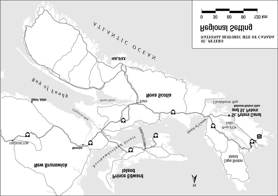
4 1.0 Introduction 1.1 BACKGROUND Canada s family of national historic sites is comprised of more than 890 sites across the country of which 148 are administered by Parks Canada. These sites symbolize significant elements of our national story. In 1929, the Historic Sites and Monuments Board of Canada declared Fort St. Peters (St. Peters) of national historic significance. St. Peters is of national historic significance because it is the site of Nicolas Denys 17th-century fortified trading post built on a narrow isthmus of land separating the Atlantic Ocean from Bras d'or Lake, an area which was used by Mi kmaq people for hundreds of years. During the period from 1713 to 1758, St. Peters, then known as Port Toulouse, became one of the three principal ports established by the French on Isle Royale (Cape Breton Island). St. Peters National Historic Site of Canada is located in the village of St. Peter s in the south western portion of the Cape Breton island, Nova Scotia (see figure 1). This national historic site illustrates the importance of commerce and trade during the 17th century and is the setting of a French community of the 18th Century. 1.2 NATIONAL HISTORIC SITES OBJECTIVES The Minister of Canadian Heritage is responsible for recognizing and commemorating persons, places and events of national historic significance in Canada. This mandate is detailed in the Parks Canada's Guiding Principles and Operational Policies (1994). They outline the objectives of the Government of Canada for the system of national historic sites. They are: C To foster knowledge and appreciation of Canada's past through a national program of historical commemoration. C To ensure commemorative integrity of national historic sites administered by Parks Canada by protecting and presenting them for the benefit, education and enjoyment of this and future generations, in a manner that respects the significant and irreplaceable legacy represented by these places and their associated resources. C To encourage and support the protection and presentation by others of places of national historic significance that are not administered by Parks Canada. The Cultural Resource Management Policy provides guidance for achieving these objectives. The goal is to manage cultural resources in accordance with the principles of value, public benefit, understanding, respect and integrity. This goal is reaffirmed in the Parks Canada Agency Act which states that Parks Canada is accountable for ensuring the commemorative integrity of national historic sites. The practice of cultural resource management requires that four elements be in place in all decision-making: C the inventory of resources; C the evaluation of resources; C the consideration of historic values; C the monitoring and review of ongoing activities. These activities are management requirements for defining and ensuring commemorative integrity. This Commemorative Integrity Statement integrates the results of the first three activities. 1
5 2
6 Figure 1. St. Peters National Historic Site of Canada in St. Peter s Nova Scotia. 1.3 COMMEMORATIVE INTEGRITY A. Definition Commemorative integrity describes the health and wholeness of a national historic site. A national historic site possesses commemorative integrity when: C the resources directly related to the reasons for the site s designation as a national historic site are not impaired or under threat, C the reasons for the site s national historic significance are effectively communicated to the public, and C the site s heritage values (including those resources and messages not related to national significance) are respected by all whose decisions or actions affect the site. Resources directly related to the reasons for the site s designation are Level 1 resources as defined in Parks Canada Cultural Resource Management (CRM) Policy. Those values, resources, and messages that are not related to national significance are defined as level 2 in the CRM policy. B. Definition and purpose of Commemorative Integrity Statement A Commemorative Integrity Statement is a site-specific elaboration of what is meant by commemorative integrity for a particular national historic site. It is intended to provide the benchmark for planning, operations and reporting. The Commemorative Integrity Statement addresses four key elements: C it focuses our management decisions on what is most important; C it ensures that there is a focus on the whole site, not just the individual resources; C it is one of the Parks Canada s Business Plan accountabilities along with service to clients and efficient use of public funds; C and it is the basis for reporting to Canadians on the state of a national historic site (State of Protected Heritage Areas Report). 3
7 2.0 Commemorative Context 2.1 HISTORICAL BACKGROUND In the 1630s, enterprising merchants from La Rochelle in France built a small fortified settlement on the shore of St. Peter s Bay, on a narrow isthmus of land separating the Atlantic Ocean from Bras d'or Lake, and named it Saint-Pierre. They were granted the rights to the fur trade and fishery in the region by the New France Company. The area was used for thousands of years by the Mi kmaq, who portaged their canoes across the isthmus separating Bras d'or Lake from the ocean. Access to the seacoast allowed them to reach other parts of their territory throughout Atlantic Canada. As well, they established seasonal camps here. It is likely that the presence of the Mi kmaq brought Portuguese, Basque and French fishermen to the area as early as the 1500s. In 1650, Nicholas Denys, another entrepreneur and merchant from La Rochelle, took possession of this settlement. During his stay, Denys encouraged the Mi kmaq to bring their furs in exchange for European goods. To facilitate shipping and transportation across the isthmus, the traditional portage trail became a haulover road where oxen, or people, could pull Denys ships from one shore to the other. During the winter of 1668/69 a disastrous fire destroyed all of Denys buildings at Saint-Pierre. The post was abandoned and Denys moved to Nipisiguit, now Bathurst, New Brunswick. In 1924, Nicolas Denys was declared to be of national historic significance because of his pioneering role in the fur trade and fishing industries in the Gulf Region, his early book on Acadia (1672) and his appointment as Governor and Lieutenant General of the Coasts and Islands of the Gulf of St. Lawrence from Canso to Gaspé, in The next chapter in the St. Peters story began in 1713 when the French established themselves on Cape Breton Island following the loss of mainland Nova Scotia and Newfoundland to the British. Saint-Pierre was renamed Port Toulouse. The core of the settlement was located about 1 km east of the old 17th-century trading post, within the current boundaries of Battery Provincial Park. The area of the trading post was renamed Petit Saint-Pierre. Port Toulouse became one of the three principal ports established on Isle Royale (now Cape Breton Island). It was a major supply centre for Louisbourg, 120 km to the north. To protect the settlement and transportation across the isthmus, the French built a small fort on the shore. In spite of optimistic plans for masonry walls, Fort Toulouse had to settle for earthworks protected by palisades. Inside the defences were the commandant s quarters, soldier s barracks, a chapel and other structures. During that period the French maintained close contact with the Mi kmaq. In 1745 and 1758, both the fort and the settlement were destroyed by the British during the wars for control of North America. British immigrants moved into the area soon after, and a prominent Irish merchant, Lawrence Kavanagh Jr., whose family contributed significantly to the growth of St. Peter s, established himself close to the ruins of Port Toulouse. In 1793, with the outbreak of war between revolutionary France and Great Britain, the British built Fort Dorchester on the summit of Mount Grenville, the highest spot in the region. When the present village of St. Peter s was founded early in the 19th century, the new residents used Denys old haulover road. Plans were soon made to replace the old portage road with a navigation channel. Work on the canal began in 1854 and in 1869 the canal finally became a reality. Today, St. Peters Canal is the only working canal of national historic significance in Atlantic Canada. The remains of Nicholas Denys fort lie buried in the garden of the Lockmaster's house which dates from Artifacts unearthed in 1985 during archaeological work on the Nicholas Denys settlement and nearby sparse ruins of Port Toulouse show the importance and sophistication of these early European sites. 4
8 A. Historic Sites and Monuments Board of Canada Recommendations A site s national historic significance is articulated in the recommendations of the Historic Sites and Monuments Board of Canada (HSMBC) to the Minister. Relevant excerpts from the minutes that contribute to the development of the Statement of Commemorative Intent follow. The complete text of the HSMBC minutes relating to Saint-Pierre has been included in Appendix 1 and plaque texts in Appendix 2. Between 1928 and 1999, the Historic Sites and Monuments Board of Canada considered the site several times. Fort St. Peters was brought to the notice of the Board in 1928 but this question was deferred until the next meeting. In 1929, the Board recommended Fort St. Peters as being nationally significant. The Board, however, delayed further action until additional historical data was made available for consideration. In 1930, the Board recommended that the following English inscription be adopted and that a French version be furnished and then placed first on the French design of the tablet. The following inscriptions were reported in the 1930 minutes: Port Toulouse Emplacement du poste établi par Nicholas Denys en Nommé Port Toulouse et fortifié à Pointe-Jérôme, ce poste devint, en 1713, l'un des trois ports principaux de l'ile Royale. Détruit par les troupe [sic] de Pepperell en 1745; repris par les Français en 1748; abandonné par eux en St. Peter's Site of Denys fort and trading post, built Selected in 1713 as one of the three principal ports in Isle Royale, named Port Toulouse, and fortified by works at Point Jerome. Destroyed by Pepperell's troupes [sic] Reoccupied by the French, 1748; evacuated, In 1931, the Board amended the text of the plaque and changed the heading Port Toulouse to Saint-Pierre Saint Pierre Emplacement du poste établi par Nicolas Denys en Nommé Port Toulouse et fortifié à Pointe-Jérôme, ce poste devint, en 1713, l'un des trois ports principaux de l'ile Royale. Détruit par les troupes de Pepperrell en 1745; repris par les Français en 1748; abandonné par eux en St. Peter s Site of Denys' fort and trading post, built Selected in 1713 as one of the three principal ports in Isle Royale, named Port Toulouse, and fortified by works at Point Jerome. Destroyed by Pepperrell's troops Re-occupied by the French, 1748; evacuated, In 1981, a local association in St. Peter s submitted a project to the Board calling for the restoration of Nicolas Denys fort and Fort Toulouse. After consideration, the Board requested the preparation of a paper which would examine in detail the extent of the cultural, political and economic impacts of the project as well as their possible archaeological significance. Parks Canada carried out exploratory excavations at St. Peter's in In 1985, a report on the excavations (The French Forts on St. Peter's Bay, Cape Breton, NS) was tabled before the Board for its consideration. The Board did not feel that it was appropriate to undertake additional commemoration of the French forts, at St. Peter s. However, in light of the exceptional research potential of St. Peters, the Board asked Parks Canada to carry out further archaeological excavations at the site and report back to the Board on its findings. In 1999, Parks Canada sought clarification from the Board on the commemorative intent, particularly the historical and geographical extent of St. Peters (Saint-Pierre, Fort St. Peters and the area known as Port Toulouse) during the French era commemorated by plaque, and the Board s intention in its deliberations. The Board confirmed that it was the entire panoply of the history of the St. Peters area from 1650 to 1758 (including the establishment of Nicolas Denys trading post and the settlement known as Port Toulouse) that was 5
9 commemorated. Hence a Statement of Commemorative Intent deals with the larger Saint-Pierre/Port Toulouse area. The Board requested further clarification from Parks Canada, however, with respect to the extent of the proposed designated place for Saint-Pierre-Port Toulouse. The Board felt that the proposed designated place did not appear to be substantiated on historical grounds and asked that Parks Canada provide further information on this question. In the 2000 meeting, the Board considered a more detailed paper and agreed with the proposed boundaries. 2.2 COMMEMORATIVE INTENT A. Definition The Commemorative Intent of a national historic site refers specifically to the reasons for a site s national significance as determined by the Ministerially-approved recommendations of the Historic Sites and Monuments Board of Canada. It is expressed in the same words used in the Board minutes. B. Statement of Commemorative Intent St. Peters was designated a national historic site in The reasons for national significance, as identified in the 2000 Board minute, are: C Its role as the site of Fort Saint-Pierre, a 17th-century fortified trading post acquired by Nicolas Denys to trade with the Mi'kmaq; and C its role as the site of Port Toulouse, a French community with its military presence that was witness to Anglo- French rivalry during the period DESIGNATED PLACE A. Definition Designated Place refers to the place designated by the Minister of Canadian Heritage on the recommendation of the Historic Sites and Monuments Board of Canada. Information on what constitutes the designated place for a particular historic site is drawn from the minutes of the Board. Designated place was previously referred to as historic place. B. Description of St. Peters Designated Place The designated place of St. Peters encompasses the central area of the Saint-Pierre/Port Toulouse area and covers approximately 28,5 ha of which 1,5 ha is the actual canal (as shown in figure 2). Specifically, the boundaries are from St. Peter s Bay, at the Atlantic Ocean entrance of the canal, following Toulouse Street, which approximates the original shoreline, to the administrative boundary of St. Peters Canal and thence north along the west side of the canal to encompass the known site of Fort Saint-Pierre and remnants of the portage route that preceded the canal that appear to survive in the wooden area above the canal cut. At the Bras d Or Lake entrance to the canal, the boundaries follow the original shoreline to encompass the location where a Mi kmaq camp was identified ca 1713 in an area that has not been significantly altered since construction of the canal in the mid 19th century when fill from the canal construction was deposited on the site. Hence, archaeological remains of this camp site may have been protected by this fill. Remnants of the farm shown as Petit Pas may also survive in this location. On the east side of the canal, limits follow Parks Canada s administrative boundaries south to the Atlantic entrance of the canal and turning inland (east) to follow traces of the road shown leading to Port Toulouse. It then turns south and east along the traces of a pathway parallel to the shoreline to encompass the area shown as farmed land and depicted with dwellings, including the priest s house. This area extends approximately 500 metres up the small creek now known as Ross Brook. Within it can 6
10 be found a series of depressions that may represent foundations of these dwellings. The boundary of the designated place then turns west down Ross Brook and along the shoreline, which is now up to 15 m further inland than it was in the 17th and 18th centuries. Hence some of the remains of the settlement may now be underwater. The boundary turns inland at the west side of Fort Toulouse and follows traces of another path (south of Mount Grenville) back to the Atlantic entrance of the canal. 7

11 Figure 2. Designated Place for St. Peters National Historic Site of Canada St. Peters National Historic Site 8
12 3.0 Resources Directly Related to the Reasons for National Significance 3.1 DESIGNATED PLACE A. Summary of Designated Place The Board confirmed that the entire settlement of St. Peters which evolved from Saint Pierre in 1650 to 1758 to become Port Toulouse is of national historic significance. The designated place of St. Peters consists of a geographical entity directly associated with the reasons for national significance. The designated place encompasses an area on the isthmus located between the shores of St. Peter s Bay and Bras d Or Lake, and generally between the administrative boundaries of St. Peters Canal National Historic Site of Canada to the east and to Ross Brook to the west, approximately 500 m from the Atlantic shoreline. The designated place encompasses the following historic features, remnants and unexcavated resources: C The emplacements of Mi kmaq camps known to be located on the lake and ocean shores. C The portage corridor linking both shores. C Areas located west of the contemporary St. Peters Canal which includes the remnants of the fortifications and structures associated with the Nicolas Denys fort (most of which are contained in what is now the yard of the Lockmaster s house built for St. Peter s Canal in 1876), the haulover road, the cemetery and remnants of the farm known as Petit Pas. These areas subsequently became known as Petit Saint-Pierre. C A large area encompassing the excavated remains of Fort Toulouse and the non excavated resources of the village of Port Toulouse for the most part within the boundaries of the present-day Battery Provincial Park. B. Historic values for the designated place The Designated Place as a whole is valued because: C it was the site of Nicolas Denys fortified trading post, which was the object of commercial rivalry during the middle of the 17th century; C it encompasses the site of subsequent French settlements from 1650 to 1758 (Petit Pas, Port Toulouse, Fort Toulouse) and their respective below-ground resources, dating from the late 17th and 18th centuries; C the place was a contact area between the French and the Mi kmaq; C the panoramas from the site and the topography give tangible evidence of the reasons for the establishment of the fortified trading post; C the haulover road was replaced by a canal in the mid-19th century which was subsequently recognized as nationally significant. C. Objectives for the designated place The designated place is not impaired or under threat when: C the cultural resources and their associated values are respected; C management decisions are based on adequate and sound information and are made in accordance with the principles and practice of the CRM Policy; C the cultural resources and their associated values are not lost or impaired from natural processes, for example erosion and decay, within or outside of the site; C the cultural resources and their associated values are not lost, impaired or threatened from human actions within or outside of the site; C the historic values of the resources are communicated to visitors and the general public; 9
13 C any modification to the site or its cultural resources is based on sound knowledge and respect for the historic values of the resources and is preceded by adequate research, recording, and investigation; C any new work at or adjacent to the site is sensitive in form and scale to the site and its associated resources; C the historic value of the resources is fully considered and integrated into the planning, conservation, presentation and operational programs. 3.2 LEVEL 1 RESOURCES A. Description of the resources IN-SITU RESOURCES ADMINISTERED BY PARKS CANADA The 17th-century Fortified Trading Post The cultural resources consist of below-ground remains and above ground features associated with the 17thcentury fortified trading post, buildings and other features on the site. The fort included earth ramparts topped by a palisade enclosing a square and surrounded by a ditch. The fort gate was in the eastern wall. The northern rampart and its northeastern corner are visible in the ground, but their contours have been heavily modified by later activities. The palisade has been reduced to stains in the soil. The base of the northern wall survives below ground as do possibly those of the eastern and western walls. The southern rampart has been lost to erosion. The structures within the ramparts included the following type of buildings: the residence for Nicolas Denys, other accommodations, storage facilities, including a granary and workshops, and a chapel. None of these structures is now visible on the ground but the burnt remains of them survive below ground. Among the surviving features which were excavated are chimney bases, plank floors set directly on large stones without a cellar and ample evidence of the household inventory as it was on the winter night of 1669 when the fort burnt. An inventory of the resources appended to this document includes a detailed explanation for each of the identified cultural resources. A map is also included locating each of the resources identified in the list (see Appendix 3) Historic Values C The Trading Post s remnants are in their original locations and reflect the original use of the fort at the time of its destruction. C The footprint, alignment and form of its earthworks and structures remain and are relatively undisturbed. C Its buried remains are an unusually rich source of information on the structure, function, activities, lifestyle, and material culture of a mid-17th-century French trading post. C The visible earthworks provide a tangible sense of the scale and form of the fort. C It is an example of early European colonial venture. C It was the object of commercial rivalry during the late 17th century. C It represents a direct association with Nicolas Denys who is a figure of national historic significance (1924). C The existing state of the grounds and below ground resources reflects the evolutionary nature of the site. Haulover Road Nicolas Denys modified a traditional Mi kmaq portage route to create a haulover road where oxen, or people, could pull Denys ships from one shore to the other. No traces of the 17th-century feature have yet been located. Historic Values C The haulover road and its function best illustrates the continuous use of the area as a transportation corridor. C The portage was valued as a short-cut and was subsequently modified by the French and British to a haulover road for transporting their vessels. Later the St. Peters Canal was constructed to replace the haulover road. C Remnants of the haulover road may be present. 10
14 IN-SITU RESOURCES NOT ADMINISTERED BY PARKS CANADA Structural Remains of Fort Toulouse These cultural resources consist of the visible or archaeologically documented remains of the fortifications and structures dating from three construction periods: 1. The Period: The fort consisted of a palisade and three buildings for officers quarters and barracks accommodating up to 60 men. 2. The Period: The fort was enlarged to enclose an area about 70 m by 80 m, and the earlier buildings were rebuilt or replaced after Ramparts with corner bastions at their northern ends enclosed a rectangular area. The fort was surrounded by a ditch with the gate in its eastern side. The structures included the Commandant s quarters, the Officers quarters, barracks, a prison, the chapel, the guardhouse, the provisions store and powder magazine, a latrine and a well. 3. The 1749/ Period: The fort was rebuilt smaller and simpler than before. The fortifications consisted of a palisade forming more or less a trapezoid enclosing an area about 50 m by 40 m. The commandant s quarters, barracks with 24 rooms for 48 soldiers, quarters for subalterns, the priest and the surgeon, a provision store and a prison were constructed within the palisade. The sparse remains are located within the boundaries of Battery Provincial Park. The resources are visible as trenches or other depressions in the ground. The remains of the fort wall, probably of the fort, are visible as a faint trench enclosing a rectangular area along the shore. Two structures were documented in the 1985 excavation. One is possibly the guardhouse of the fort. The other is probably the cellar of the commandant s quarters in the 1749/ fort. The excavations indicated that the archaeological resources are substantial. The fort was destroyed by the British in 1745 and in Historic Values C The structural remains of Fort Toulouse are directly associated with the commemorative intent of St. Peters. C They are in their original location. C The footprint, alignment and form of the earthworks remain and are relatively undisturbed. C They are a source of information on the structure, function, activities, and material culture of mid-18th century French forts. C The fort was an administrative center for Southeast Isle Royale (Cape Breton Island). C The bay and isthmus were valued for their strategic importance by the French and it was the location of a small garrison. C The site (Fort Toulouse-Port Toulouse) was a point of contact in the military alliance with the Mi kmaq (with respect to battles in Nova Scotia). C The fort was a victim of British-French rivalry and was captured and destroyed twice (in 1745 and 1758). Village of Port Toulouse The village was established east of Fort Toulouse in 1716 and lasted until 1745, when it was destroyed by the British. It was resettled in At that time it grew to include about 40 families. After 1758, it came under English authority. The village consisted of clusters of buildings, most of them near Ross Brook. A road led into the village from the head of St. Peter s Bay, rounding Mount Grenville, with a branch into the fort. A road to Louisbourg was built in Remains of the village can be distinguished in air photos and as depressions or ridges in the ground, but most of what is left of the structures is below ground. Neither the buildings nor the associated fields have been the subject of archaeological testing. 11
15 Historic Values C The village of Port Toulouse was one of three principal French settlements on Cape Breton Island during the commemorated period, and was a major supply center for the Fortress of Louisbourg. C Fort Toulouse-Port Toulouse was the site of an annual ceremony of French-Mi kmaq alliance renewal. C The population of the village traded with the British at Canso. C The area was the most prominent settlement of re-located Acadians on Cape Breton Island resulting in a strong relationship between Port Toulouse and Isle Madame and links to other communities on the island. C The area was a site of French-British conflict in 1745 and C The French and Acadian settlers were deported to France in 1745 and C The area is the ancestral home of some Acadian Cape Breton families. OBJECTS ADMINISTERED BY PARKS CANADA A collection of about 1,100 artifacts, 20 animal bones and other specimens were excavated from the 17th-century fort. They consist of architectural items such as daub, brick tiles, nails, tie bolts, window glass and lead, munitions, weapons such as gun parts, gun flints, and a dagger, tools such as axes and a hoe, household items of iron, copper, ceramics and glass, furniture tacks, tobacco clay pipes, and highly ornate items. The archaeological collection is stored in the Parks Canada Cultural Resources Management Archaeology storage facility in the Trade Mart, Halifax. A few artifacts were lent to the Nicolas Denys Museum in St. Peter s and are currently on display. Historic Values C The objects illustrate the activities, lifestyle, and material culture of the commemorated period. C They are a direct link with Nicolas Denys, a person who was declared of national historic importance by the Historic Sites and Monuments Board of Canada in C The collection, as a whole, is an unusually rich source of information on the structure, function and use of a mid-17th-century French trading post at the time of its abrupt destruction. OBJECTS ADMINISTERED BY PARKS CANADA FOR THE PROVINCE A collection associated with Fort Toulouse includes about 500 archaeological objects consisting of building hardware, wattle-and-daub, white-washed daub, burnt wood, bricks, household ceramics, a French coin from 1711, gun flints, pipe fragments, brass buttons and a piece of silver uniform braid. The collection includes the food bones of birds and sea mammals. The collection is owned by the Government of Nova Scotia. An official agreement has been signed with the Nova Scotia Museum to retain the collection in the Parks Canada Cultural Resources Management Archaeology storage facility in Halifax. Historic Value C The archaeological collection, as objects and as a whole, illustrates the activities, lifestyle, and material culture of the commemorated period. B. Objectives for the resources All resources, in-situ resources and objects, will not be impaired or under threat when: C the cultural resources and their associated values are respected; C management decisions are based on adequate and sound information and are made in accordance with the principles and practice of the CRM Policy; 12
16 C the cultural resources and their associated values are not lost or impaired from natural processes, for example erosion and decay, within or outside of the site; C the cultural resources and their associated values are not lost, impaired or threatened from human actions within or outside of the site; C the historic values of the resources are communicated to visitors and the general public; C the historic value of the resources is fully considered and integrated into the planning, conservation, presentation and operational programs; C any new work at or adjacent to the site is sensitive in form and scale to the site and its associated resources; C there are no uses or threats that reduce the potential for long-term conservation and future understanding and appreciation of the cultural resources; C conservation measures are based on direct, rather than indirect evidence, follow the path of least intrusive action, and are clearly recorded; C monitoring and review systems are in place to ensure the continued survival of the cultural resources with minimum deterioration. 13
17 4.0 Messages of National Significance 4.1 MESSAGES OF NATIONAL SIGNIFICANCE This second element of a site s commemorative integrity relates to heritage presentation, which facilitates public understanding of national significance. It focuses on the reasons for national historic significance, and is derived from the Commemorative Intent of St. Peters National Historic Site of Canada. Messages of national significance are Level I messages which convey the reasons for the site s designation or for its national significance and must be effectively communicated to both site visitors and the general public. Context messages are messages which aid in understanding the reason for the national significance of the site. The messages that convey the national historic significance of St. Peters National Historic Site of Canada are: C St. Peters was the site of Fort Saint-Pierre, a 17th-century fortified trading post acquired by Nicolas Denys in 1650 to trade with the Mi kmaq. C St. Peters was the site of Port Toulouse, a French community with its military presence that was witness to Anglo-French rivalry during the period 1713 and CONTEXT MESSAGES Context messages are those messages which are essential for an understanding of the reason(s) for the national significance of St. Peters. These are: C The major alliances between the French and the Mi kmaq were fostered by the military, social and commercial relationships that established and maintained Saint-Pierre. C St. Peters (then known as Port Toulouse) was the scene of conflicts in 1745 and 1758 between the French and British during the struggle for empire in the 18th century. C The area was an Acadian settlement between 1713 and C A pioneer in fur trade and in the fishing industry and author of an early book on Acadia (1672), Nicolas Denys was appointed Governor and Lieutenant General of the Coasts and Islands of the Gulf of St. Lawrence from Canso to Gaspé in 1654 and was subsequently declared of national historic significance by the Historic Sites and Monuments Board of Canada in OBJECTIVES FOR MESSAGES OF NATIONAL SIGNIFICANCE Effective communication of the reasons for national significance of St. Peters National Historic Site of Canada, as expressed in the messages of national significance and the context messages, will be achieved when: C the overall heritage presentation experience conveys the reasons for national significance of the site; C the public, both visitors and non-visitors, exposed to a heritage presentation experience and the site stewards understand the reasons for national historic significance of the site; C the effective communication of messages and their understanding is monitored. 14
18 5.0 Heritage Values 5.1 RESOURCES NOT RELATED TO NATIONAL SIGNIFICANCE This element of commemorative integrity deals with all other resources and messages that upon evaluation do not meet criteria established for Level I. Level II resources are not of national significance, however, their local or regional association, historical significance and aesthetic or environmental qualities are valued. A feature, a resource or a landscape which is valued for its evolution, was a witness to many periods in history or is given special cultural meaning by people, may be assigned to a level II. The sites where these resources would be located is given in parentheses. Portage Route (Parks Canada) The route was used for thousands of years by the Mi kmaq, who portaged their canoes across the isthmus separating Bras d'or Lake from the ocean. It is not known whether any remnants survive. Historic Values C The portage route allowed the Mi kmaq to reach other parts of their territory throughout Atlantic Canada. C The isthmus was a passage point for Mi kmaq annual gatherings. Mi kmaq Camps (Parks Canada, Battery Provincial Park) The camps were indicated on a map (ca. 1714) at both ends of the portage route. These camps may have been preserved under fill placed on the site during construction of the canal. Although no remains have yet been located, there is relatively high probability of finding Aboriginal resources relating to the camps on the Bras d Or lake end side of the canal. Historic Values C The presence of the camps represent the use and occupation of the area by the Mi kmaq. Cemetery (Location unknown) It is presumed that a cemetery was established during the forty years the Trading Post was in operation although documents contain no reference to it. The cemetery could be located close to the Post but outside the walls as seen at other habitations (eg. Port-Royal). Important persons would have been buried in the Chapel. Tradition states that a skeleton was discovered when the basement of the Lockmaster s house was dug. No records exist to confirm this report. Historic Value C The cemetery represents the culture of the French inhabitants. Farm Buildings of Petit Saint-Pierre and Petit Pas (Parks Canada and Municipality) Possible remnants of farm buildings both on St. Peter s Bay and Bras d Or Lake as indicated on a map (ca. 1731). The occupation was primarily contemporary with that of Port Toulouse. Historic Value C The remnants illustrate the activities, lifestyle, and culture of the commemorated period. Remains of Fort Dorchester (Battery Provincial Park) Built in , the fort was used only a short time. The resources are buried but the basic outline is still visible. They have not been investigated archaeologically. When cleared of vegetation, their present surface contours are clearly visible. Historic Values C The remains are tangible evidence illustrating the continuity in the use of this strategic place and the historical evolution of the site. 15
19 C They are tangible evidence of the British occupation of the place and an illustration of British reaction in North America to the declaration of war by revolutionary France. C The remnants of the structures are in their original location and their footprint and form remain. C The site offers a commanding view of the local area and the three principal waterway routes (St. Peter s inlet from Bras d Or Lake; St. Peter s Bay between Mainland Nova Scotia and Cape Breton and Isle Madame; and Lennox Passage going towards Strait of Canso). Remains of the Lawrence Kavanagh Property (Battery Provincial Park) The Kavanagh family and the remains of their estate are of great local historic significance and interest. The insitu resources consist of the remains of the residence and surrounding outbuildings built c by Lawrence Kavanagh Jr. on a 500-acre property situated in Port Toulouse after the entire area was renamed St. Peter s. These structures can be seen as overgrown outlines near the shore. There are also the remains of a large three-story residence which became the Kavanagh residence in 1811 after the first house was destroyed in a gale. The footprint of this house is visible about 160 m north of the shore in the Battery Provincial Park. Historic Values C The remains of the Kavanagh property are a tangible link to the history of the community of St. Peter s and illustrate the historical evolution of the site. C The remnants of the structures are in their original location. C The Kavanagh family was a prominent family in the community (political, commercial, social). C One member of the family became the first elected Catholic member of a legislative assembly in the British Empire outside of Quebec. The cement foundation of the Richmond County hospital (Battery Provincial Park) The hospital was built in 1911 directly on the foundation of the 1811 Kavanagh house after the latter was demolished. The hospital burned in Ruins are still visible within the forested area of the Battery Provincial Park. Historic Value C The remains illustrates the evolution of the site. Designated Place of St. Peters Canal National Historic Site of Canada (Parks Canada) The area of the Designated Place of St. Peters Canal National Historic Site is embedded in the St. Peters National Historic Site of Canada. A description of its historic features and commemorative integrity objectives may be found in the St. Peters Canal Commemorative Integrity Statement. Historic Values C The site has been used as a transportation corridor between the Atlantic Ocean and the Bras d'or Lake since time immemorial. C The presence and interrelationship of the canal waterway, works, buildings and landscape features are tangible evidence of the historical evolution of the site. Historic Sites and Monuments Board of Canada Plaques (Parks Canada) Two plaques of the Historic Sites and Monuments Board of Canada are erected on a cairn located on the southeastern corner of the Lockmaster s house. The first plaque commemorates the settlement of Saint-Pierre and the Nicolas Denys fortified trading post and communicates the reasons for the national significance of Saint- Pierre National Historic Site. The second plaque commemorates St. Peters Canal. Historic Value C The plaques represent early efforts to commemorate Canada's history by the federal government. 16
20 5.2 OBJECTIVES All Level 2 resources will not be impaired or under threat when the objectives given in section 3.1C are met. 5.3 MESSAGES AND OBJECTIVES NOT RELATED TO NATIONAL SIGNIFICANCE The messages communicate an awareness and appreciation of the heritage values associated with St. Peters National Historic Site of Canada. These heritage values are not directly linked to the messages of national significance and the site s commemorative intent. The Mi kmaq Presence C The Mi kmaq used this place as a portage crossing establishing seasonal camps here as the need arose. C From 1713 to 1758, when this area was known as Port Toulouse, the Mi kmaq held annual meetings here with French colonial officials from Louisbourg and the local missionary concerning the alliance between the two peoples. C The Mi kmaq heritage is visible in the nearby local area. Early Europeans C In the early 16th century, Portuguese fishers may have used this place and called it San Pedro. The French and Acadian Settlement C There were commercial, administrative, and political relationships between Port Toulouse and other French communities on Isle Royale. C The Acadian and other French inhabitants were deported by the British in 1745 and C The Acadian and French heritage is visible in the nearby local area. The Historical Relationship with other National Historic Sites C The Level I message and context messages of St. Peters Canal are associated with the story of St. Peters. These messages are fully described in the St. Peters Canal Commemorative Integrity Statement. C St. Peters National Historic Site of Canada is thematically related to many other sites in Atlantic Canada that witnessed Aboriginal, French, Acadian and British political, military and commercial interaction, including: Port-Royal, Fort Anne, Canso Islands, Port-la-Joye--Fort Amherst, Fort Beauséjour, the Fortress of Louisbourg, Boishébert, and Castle Hill National Historic Sites. The Development of the Community of St. Peter s C Saint-Pierre - Port Toulouse became the modern town of St. Peter s in the post-1758 period. C The canal played a critical role in the development of the community. C The Kavanagh family contributed significantly to the establishment and growth of St. Peter s. C A nationally acknowledged photographer, Wallace MacAskill, was born here. C The site is adjacent to the remains of Fort Dorchester, built The National Historic Sites System C St. Peters National Historic Site of Canada is part of a family of over 890 sites nation-wide. C St. Peters National Historic Site of Canada is a place designated by the Government of Canada as a site of importance to all Canadians because of its national significance. Effective communication of the messages not related to the national significance of Saint-Pierre National Historic Site will be achieved when: C part of the heritage presentation experience conveys the message not related to the site s national significance; C the messages not related to the site s national significance and their presentation do not overwhelm or detract from the presentation and understanding of the site s national significance; C the public, both visitors and non-visitors, exposed to messages not related to the site s national significance understand them; 17
21 C the effectiveness of the communication of the messages not related to the site s national significance and their understanding are monitored. 18
22 Acknowledgment Developing a Commemorative Integrity Statement for St. Peters National Historic Site of Canada was an interesting, learning experience for all members of the Planning Team. This task required considerable work, research of background information and interdisciplinary discussions as well as many reviews. The following individuals participated in the development of the Commemorative Integrity Statement: Rob Ferguson, Archaeologist, Atlantic Service Centre, Halifax John Johnston, Historian, Atlantic Service Centre, Halifax Denyse Lajeunesse, Planner, Atlantic Service Centre, Halifax Tom Meagher, Manager Historic Sites, Asset Management, Cape Breton Island Field Unit, Fortress of Louisbourg Anne O Neill, Manager, Heritage Presentation and Client Services, Cape Breton Island Field Unit, Fortress of Louisbourg Bill O Shea, Manager, Cultural Resources, Cape Breton Island Field Unit, Fortress of Louisbourg Judith Tulloch, Historian, Atlantic Service Centre, Halifax Carol Whitfield, Field Unit Superintendent, Cape Breton Island Field Unit Birgitta Wallace, Archaeologist, Halifax Colleagues and resource people at the National Historic Sites Directorate, National Office, and the Atlantic Service Centre, Halifax, also provided sound advice, guidance and technical support throughout the project. François Marineau Planner Atlantic Service Centre, Halifax 19
23 Appendix 1 Relevant Excerpts from the Historic Sites And Monuments Board of Canada Minutes Ottawa, Thursday, May 17, 1928 Fort St. Peters, N.S. That this matter be deferred until the next meeting of the Board, and that in the interval a memorandum of justification and an inscription be prepared and submitted by Judge Crowe. Carried. Ottawa, 18th May, 1929 Fort St. Peters. That the site of Fort St. Peters be declared of national importance, and that further action be deferred until the next meeting of the Board to enable further historic data being obtained relative thereto. Monday, May 19, 1930 Fort St. Peter's. That the following inscription in English be adopted; that Mr. Nantel be asked to furnish a French version, and that the French version be placed first on the French design of tablet. PORT TOULOUSE Emplacement du poste établi par Nicholas Denys en Nommé Port Toulouse et fortifié à Pointe-Jérôme, ce poste devint, en 1713, l'un des trois ports principaux de l'ile Royale. Détruit par les troupe de Pepperell en 1745; repris par les Français en 1748; abandonné par eux en St. PETER'S Site of Deny's fort and trading post, built Selected in 1713 as one of the three principal ports in Isle Royale, named Port Toulouse, and fortified by works at Point Jerome. Destroyed by Pepperell's troupes Re-occupied by the French, 1748; evacuated,
24 May 28, 1931 St. PETERS, N.S. That the following inscription as amended be confirmed with the change in the heading "Port Toulouse" to "Saint Pierre" in the French version. SAINT PIERRE Emplacement du poste établi par Nicolas Denys en Nommé Port Toulouse et fortifié à Pointe-Jérôme, ce poste devint, en 1713, l'un des trois ports principaux de l'ile Royale. Détruit par les troupes de Pepperrell en 1745; repris par les Français en 1748; abandonné par eux en St. PETERS Site of Denys' fort and trading post, built Selected in 1713 as one of the three principal ports in Isle Royale, named Port Toulouse, and fortified by works at Point Jerome. Destroyed by Pepperrell's troops Re-occupied by the French, 1748; evacuated, June 15 and 16, 1981 THE FRENCH FORTS, St. PETER S, NOVA SCOTIA Recognizing that the site of Nicholas Deny's Fort had been commemorated by means of a plaque as early as 1931, the Board recommended that the question of further commemoration of the French Forts constructed at St. Peter's, Nova Scotia, be deferred until such time as a paper which examines in greater detail the extent of the cultural, political, and economic impact of the forts as well as their possible archaeological significance can be prepared for the Board's consideration. November 15 and 16, 1985 THE FRENCH FORTS, St. PETER'S, NOVA SCOTIA Background In 1931, Fort Saint Pierre (Nicholas Denys' Fort) and Port Toulouse were commemorated by means of a plaque entitled St. Peters'. In June of 1981, the Board considered the question of further commemoration at the site (restoration of the two forts) at the request of the St. Peter's Community Club. At that time the Board recommended that "the question of further commemoration of the French Forts constructed at St. Peter's, Nova Scotia, be deferred until such time.as a paper which examines in greater detail the extent of the cultural, political and economic impact of the forts as well as their possible archaeological significance can be prepared for the Board's consideration." 21
25 While the paper requested, above, has not been completed, due to the scarcity of staff resources, exploratory excavations were carried out at St. Peter's last summer by archaeologists from the Atlantic Regional Office, Parks Canada. The paper The French Forts on St. Peter's Bay, Cape Breton, N.S. concerned these archaeological test excavations and was tabled before the Board for its consideration. Recommendations The Board did not feel that it was appropriate to undertake additional commemoration of the French Forts, at St. Peter's, at least for the time being, however, it did recommend that "in light of the apparently exceptional research potential of Fort St. Pierre, Parks Canada should carry out further archaeological excavations at the site, at its earliest opportunity, and report back to the Board on its findings." Ottawa, June 1999 Clarification of National Historic Site Designation: St. Peter s, Nova Scotia In order to develop the Commemorative Integrity Statement for St. Peters National Historic Site, Parks Canada has sought clarification from the Board on the commemorative intent for this site. In 1929, Fort St. Peters was designated a national historic site on the advice of the Board and a commemorative tablet was erected in Secretary s Note: While the Board was prepared to approve the proposed commemorative intent and boundaries for the site, after further consideration of the Board s proceedings on this subject, Dr. Alway felt that further clarification was required from Parks Canada with respect to the extent of the proposed historical place for St. Peters/Port Toulouse. Dr. Alway felt that the proposed historical place did not appear to be substantiated on historical grounds and asked that Parks Canada provide the Board with further information on this question. 22
26 June 2000 St. Peters National Historic Site: Confirmation of Commemorative Intent and Clarification of Designated Place In June 1999, the Board reviewed a staff report on this subject and approved, with minor adjustments, the proposed Statement of Commemorative Intent, as follows St. Peters is a place of national historic significance because of its role C as the site of Fort Saint-Pierre, a 17th-century fortified trading post acquired by Nicolas Denys to trade with the Mi kmaq; and C as the site of Port Toulouse, a French community with its military presence that was witness to Anglo-French rivalry during the period The Board however, was not prepared to bring forward its recommendation at that time because it required further clarification with respect to the definition of designated place. Parks Canada has now come forward with revised boundaries for the proposed designated place. The revisions, which reduce the area considerably from what was proposed in June 1999, are based on a site inspection and on stereoscopic examination of aerial photographs and comparison of the results with 18th-century maps. On the basis of the information brought before it, the Board reaffirmed its June 1999 recommendation with respect to the Statement of Commemorative Intent, and approved the following verbal description of the proposed designated place. Specifically, the recommended boundaries are from St. Peter s Bay, at the Atlantic Ocean entrance of the canal, following Toulouse Street, which approximates the original shoreline, to the administrative boundary of St. Peters Canal and thence north along the west side of the canal to encompass the known site of Fort Saint- Pierre and remnants of the portage route that preceded the canal that appear to survive in the wooded area above the canal cut; at the Bras d Or Lake entrance to the canal, following the original shoreline to encompass the location where a Mi kmaq camp was identified ca in an area that has not been significantly altered since construction of the canal in the mid-19th century when fill from canal construction was deposited on the site. Hence archaeological remains of this camp may have been protected by this fill. Remnants of the farm known as Petit Pas (Fig. 2, OB-08) may also survive in this location; on the east side of the canal, following Parks Canada administrative boundaries south to the Atlantic entrance to the canal and turning inland (east) to follow traces of the road leading to Port Toulouse (Figs. 2 and 3, OB-08). Turning south and then east along the traces of a pathway parallel to the shoreline to encompass the area shown as farmed land in Figure 1 (OB-08) and depicted with dwellings, including the priest s house (Figs. 2 and 3, OB-08). This area extends approximately 500 metres up the small creek now known as Ross Brook. Within it can be found a series of depressions that may represent foundations of these dwellings; and, the boundary of the designated place then turns west along Ross Brook and along the shoreline, which is now up to 15 metres further inland than it was in the 17th and 18th centuries. Hence 23
27 some of the remains of the settlement may now be underwater. The boundary turns inland at the west side of Fort Toulouse and follows traces of another path (south of Mount Granville) back to the Atlantic entrance to the canal. The total area within the proposed boundaries is approximately 28.5 hectares, of which 1.5 hectares is the actual canal. While the Board was prepared to accept the verbal description of the designated place, it asked that Parks Canada undertake to survey the boundaries for St. Peters National Historic Site as soon as possible and to return to the Board with confirmed survey boundaries to validate the above boundary description. 24
28 Appendix 2 Plaque Texts SAINT PIERRE Emplacement du poste établi par Nicolas Denys en Nommé Port Toulouse et fortifié à Pointe-Jérôme, ce poste devint, en 1713, l'un des trois ports principaux de l'ile Royale. Détruit par les troupes de Pepperrell en 1745; repris par les Français en 1748; abandonné par eux en St. PETERS Site of Denys' fort and trading post, built Selected in 1713 as one of the three principal ports in Isle Royale, named Port Toulouse, and fortified by works at Point Jerome. Destroyed by Pepperrell's troops Re-occupied by the French, 1748; evacuated, A.D St. PETER S CANAL LE CANAL SAINT-PIERRE Connecting St. Peter s Bay on the Atlantic Ocean with the Bras d Or Lakes, St. Peter s Canal follows substantially the portage of the old French trading days. The route was first surveyed in 1825 but construction did not commence until 1854, was suspended in 1856, renewed in 1865, and not completed until Since that time the canal has been twice enlarged and can now accommodate vessels with draughts up to sixteen feet. Ce canal, qui relie la baie St. Peter s, sur l Atlantique, aux lacs Bras d Or, suit plus ou moins le vieux chemin de portage du Régime français. Son tracé fut d abord arpenté en 1825 mais sa construction, entreprise en 1854, interrompue en 1856 et reprise en 1865, ne fut terminée qu en Élargi deux fois depuis, le canal peut recevoir des navires ayant seize pieds de tirant d eau. Historic Sites and Monuments Board of Canada Commission des Sites et des Monuments Historiques du Canada Government of Canada-1931-Governement du Canada 25
29 Appendix 3 Inventory of Resources and Designated Place DESIGNATED PLACE As described in section 2.3B. IN-SITU LEVEL 1 RESOURCES The 17th-century Fortified Trading Post The in situ cultural resources consist of below-ground remains and above ground features associated with the 17th-century fortified trading post, buildings and other features on the site. The structures within the ramparts included the following type of buildings: the residence for Nicolas Denys, other accommodations, storage facilities, among them a granary and workshops, and a chapel (7 1 ). Haulover Road No traces of the 17th-century structure are known (hatched area). Structural remains of Fort Toulouse These resources consist of the visible or archaeologically documented remains of the fortifications and structures dating from three construction periods, , , and The remains are located in Battery Provincial Park (4). Village of Port Toulouse The village was established in 1716 which lasted until 1745 when it was destroyed by the British. It was resettled in 1749 and came under British authority in Remains of the village can be distinguished in air photos and as depressions and ridges in the ground. Most of what is left of the structures is below ground. It has not been subject to archaeological testing. The remains are located in Battery Provincial Park (6). LEVEL 1 OBJECTS Objects associated with the 17th-century Fortified Trading Post The collection contains about 1100 artifacts, 20 animal bones, and other specimens excavated from the 17th-century fort. The collection consists of items such as daub, brick tiles, nails, tie bolts, window glass and lead, munitions, weapons such as gun parts, gun flints, and a dagger, tools such as axes and a hoe, household items of iron, copper, ceramics and glass, furniture tacks, tobacco clay pipes, and 1 Numbers in parentheses refer to the numbers on figure 3. 26
30 highly ornate items (stored in the Parks Canada Cultural Resources Management Archaeology storage facility in Halifax. Objects associated with Fort Toulouse The collection includes about 500 archaeological objects consisting of building hardware, wattle-and-daub, white-washed daub, burnt wood, bricks, household ceramics, a French coin from 1711, gun flints, pipe fragments, brass buttons and a silver uniform braid. It also includes the food bones of birds and sea mammals. The collection is owned by the Government of Nova Scotia. An official agreement has been signed with the Nova Scotia Museum to retain the collection in the Parks Canada Cultural Resources Management Archaeology storage facility in Halifax. LEVEL 2 RESOURCES Portage route The route was used by the Mi kmaq who portaged their canoes across the isthmus separating Bras d Or Lake from the ocean. It is not known if remnants survive. Mi kmaq camps There may still be traces of the camp at Bras d Or Lake as the canal approaches have been built out beyond the original shoreline (2). Cemetery A cemetery was presumably located outside the fort, but its location is not known. Farm Buildings of Petit Saint-Pierre and Petit Pas Petit Saint-Pierre and Petit Pas consisted of a few buildings, both on St. Peter s Bay and Bras d Or Lake, including what was perhaps originally the farm of La Montagne. The occupation was primarily contemporary with that of Port Toulouse (1 & 8). Remains of Fort Dorchester (Fort Grenville) Remains include below ground remains of the fort in 1793/94. The basic outline is still visible. This is located on top of Mount Grenville in Battery Provincial Park (3). Remains of the Lawrence Kavanagh Property The estate consists of the remains of the residence and surrounding outbuildings built c by Lawrence Kavanagh Jr., in the area of the Port Toulouse priest s house, and remains of a large three-story residence which became the Kavanagh residence in 1811 (5). The cement foundation of the Richmond County hospital The hospital was built in 1911 directly on the foundation of the 1811 Kavanagh house after the latter was demolished. The hospital burned in 1920 (5). Designated Place of St. Peters Canal National Historic Site of Canada 27
31 The area of the Designated Place of St. Peters Canal National Historic Site which is partly embedded in the Saint-Pierre National Historic Site. A description of its historic features and commemorative integrity objectives may be found in the St. Peters Canal Commemorative Integrity Statement. Historic Sites and Monument Board of Canada Plaques Two Historic Sites and Monument Board of Canada plaques are erected on a single cairn located on the southeastern corner of the Lockmaster s house (9). 28

32 St. Peters National Historic Site of Canada Figure 3. Location of the resources described in the appendix. 29
The Settlement of A New Land : Canada
 The Settlement of A New Land : Canada Part One : 1600-1713 DIVITO 2018 In the beginning: After the discovery of the great fishing along the coast of the Atlantic Provinces, fertile land along the St. Lawrence,
Fort Carillon/Ticonderoga
 Fort Carillon/Ticonderoga A P H O T O G R A P H I C H I S T O R Y B E H I N D T H E S T R A T E G I C K E Y T O B O T H B R I T I S H A N D A M E R I C A N V I C T O R I E S I N T H E N O R T H. S E V
BRIEF TO THE ROYAL COMMISSION ON ABORIGINAL PEOPLES THE NUNAVIK CONSTITUTIONAL COMMITTEE
 BRIEF TO THE ROYAL COMMISSION ON ABORIGINAL PEOPLES THE NUNAVIK CONSTITUTIONAL COMMITTEE MAY, 1993 EXECUTIVE SUMMARY - This brief is submitted by the Nunavik Constitutional Committee. The Committee was
PROUDLY BRINGING YOU CANADA AT ITS BEST. Management Planning Program NEWSLETTER #1 OCTOBER, 2000
 PROUDLY BRINGING YOU CANADA AT ITS BEST VUNTUT NATIONAL PARK Management Planning Program NEWSLETTER #1 OCTOBER, 2000 INTRODUCTION This newsletter launches the development of the first management plan for
I I I I LINDEN TO WOOD FORD SURVEY ITEMS OF HISTORICAL SIGNIFICANCE I I I I I I I I I I I I I
 LNDEN TO WOOD FORD SURVEY TEMS OF HSTORCAL SGNFCANCE ------------------------------------------------------------------------------ --- - CONTENTS OF THE REPORT 1.0 ntroduction to the Report 1.1 Parameters
archeological site LOS MILLARES
 archeological site LOS MILLARES Aerial view of the plain of Los Millares between the Rambla de Huéchar and the River Andarax The archaeological site of Los Millares is located in the township of Santa
The French Period
 The French Period 1500-1763 The Beginning On June 29 th 1534 Jacques Cartier arrived on the Island. He explored for two days from Malpeque to Tignish. Cartier commented on the lack of good harbors. Cartier
Part 5 War between France and Great Britain
 Part 5 War between France and Great Britain The objects of colonial rivalries PAGE 111 France Wanted to control the fur trade Expand their territory Great Britain Wanted to control the fur trade Expand
Part 5 War between France and Great Britain
 Part 5 War between France and Great Britain The objects of colonial rivalries PAGE 117 France Wanted to control the fur trade Expand their territory Great Britain Wanted to control the fur trade Expand
Provincial Archaeology Office Annual Review
 2017 Provincial Archaeology Office Annual Review Provincial Archaeology Office Department of Tourism, Culture, Industry and Innovation Government of Newfoundland and Labrador March 2018 Volume 16 A brief
PUBLIC ACCOUNTABILITY PRINCIPLES FOR CANADIAN AIRPORT AUTHORITIES
 PUBLIC ACCOUNTABILITY PRINCIPLES FOR CANADIAN AIRPORT AUTHORITIES The Canadian Airport Authority ( CAA ) shall be incorporated in a manner consistent with the following principles: 1. Not-for-profit Corporation
Fortress of Louisbourg National Historic Site of Canada
 NOVEMBER 2011 Fortress of Louisbourg National Historic Site of Canada Management Plan ii Her Majesty the Queen in Right of Canada, represented by the Chief Executive Officer of Parks Canada, 2011. Cette
CITY OF VAUGHAN EXTRACT FROM COUNCIL MEETING MINUTES OF OCTOBER 30, 2012
 CITY OF VAUGHAN EXTRACT FROM COUNCIL MEETING MINUTES OF OCTOBER 30, 2012 Item 36, Report No. 39, of the Committee of the Whole, which was adopted without amendment by the Council of the City of Vaughan
Establishing a National Urban Park in the Rouge Valley
 STAFF REPORT ACTION REQUIRED Establishing a National Urban Park in the Rouge Valley Date: March 29, 2012 To: From: Wards: Reference Number: Executive Committee Deputy City Manager, Cluster B All p:\2012\cluster
Department of Tourism, Culture and Recreation Provincial Archaeology Office 2012 Archaeology Review February 2013 Volume 11
 Department of Tourism, Culture and Recreation Provincial Archaeology Office 2012 Archaeology Review February 2013 Volume 11 Area 14 of FjCa-14 in Sheshatshiu, portion of feature in southeast corner of
SUMMER VILLAGE OF SILVER SANDS. Municipal Development Plan
 SUMMER VILLAGE OF SILVER SANDS Municipal Development Plan Bylaw 253-2014 Adopted August 22, 2014 Summer Village of Silver Sands Municipal Development Plan Bylaw No. 253-2014 Page 2 1 INTRODUCTION 1.1 SETTING
CONTENTS. 1 Introduction Always Moving Forward while Building on the Past A Dynamic Destination... 5
 2010 STRUCTURE PLAN - 2 - CONTENTS 1 Introduction... 5 1.1 Always Moving Forward while Building on the Past... 5 1.2 A Dynamic Destination... 5 2 Map A... 6 Exhibition Place and its Neighbours... 7 3 Demonstration
Archaeology Newsletter
 KMKNO Archaeology: From the Ground Up Issue #3 KMKNO ARCHAEOLOGY Department From the Ground Up: Archaeology Newsletter March 2016 Artefacts excavated from a site on Antigonish Harbour, dating from perhaps
UNITED STATES DEPARTMENT OF THE INTERIOR BUREAU OF LAND MANAGEMENT MANUAL TRANSMITTAL SHEET
 Form 1221-2 (June 1969) UNITED STATES DEPARTMENT OF THE INTERIOR BUREAU OF LAND MANAGEMENT MANUAL TRANSMITTAL SHEET Release 8-83 Date Subject 8353 Trail Management Areas Secretarially Designated (Public)
Crown Corporation Business Plans. Trade Centre Limited
 Crown Corporation Business Plans Trade Centre Limited Contents Message from the CEO and the Chair... 5 Mandate... 7 Alignment with Government s Priorities... 7 Core Responsibilities... 9 Budget Context...
Human Geography of Canada
 Human Geography of Canada History and Government of Canada Like the United States, people migrated across Beringia into Canada, these people were the ancestors of the Inuit (Eskimos) 16 th and 17 th centuries,
LATIN AMERICA / CARIBBEAN COIBA NATIONAL PARK PANAMA
 LATIN AMERICA / CARIBBEAN COIBA NATIONAL PARK PANAMA WORLD HERITAGE NOMINATION IUCN TECHNICAL EVALUATION COIBA NATIONAL PARK (PANAMA) ID Nº 1138 Bis Background note: Coiba National Park was nominated for
Channel Islands Occupation Society
 INTRODUCTION The subject of the Conservation Statement is Kempt Tower, built in 1834 in St Ouen s Bay, Jersey. The primary purpose of the statement is to draw together existing information, to set down
Cascade River State Park Management Plan Amendment
 This document is made available electronically by the Minnesota Legislative Reference Library as part of an ongoing digital archiving project. http://www.leg.state.mn.us/lrl/lrl.asp Cascade River State
New Studies in the City of David The Excavations
 The 2013-2014 Excavations Israel Antiquities Authority The intensive archaeological work on the city of David hill during the period covered in this article has continued in previously excavated areas
Gorse Stacks, Bus Interchange Excavations Interim Note-01
 Gorse Stacks, Bus Interchange Excavations 2015 Prepared for: Cheshire West & Chester Council Interim Note-01 1 Introduction & Summary Background Since c. 2000 investigations associated with redevelopment
CASTLE OF OLD WICK HISTORIC ENVIRONMENT SCOTLAND STATEMENT OF SIGNIFICANCE. Property in Care(PIC) ID: PIC282 Designations:
 ID: PIC282 Designations:") Property in Care(PIC) ID: PIC282 Designations: Scheduled Monument (SM90065) Taken into State care: 1957 (Guardianship) Last reviewed: 2004 HISTORIC ENVIRONMENT SCOTLAND STATEMENT OF SIGNIFICANCE CASTLE
Property in Care(PIC) ID: PIC282 Designations: Scheduled Monument (SM90065) Taken into State care: 1957 (Guardianship) Last reviewed: 2004 HISTORIC ENVIRONMENT SCOTLAND STATEMENT OF SIGNIFICANCE CASTLE
Chapter 9: National Parks and Protected Areas
 Part 9.1 Torngat Mountains National Park Reserve 9.1.1 The area set out in the Map Atlas (shown for illustrative purposes only in schedule 9-A) and described in appendix D-2 shall become a National Park
Chiselbury Camp hillfort
 Chiselbury Camp hillfort Reasons for Designation Large univallate hillforts are defined as fortified enclosures of varying shape, ranging in size between 1ha and 10ha, located on hilltops and surrounded
The Battle of Quebec: 1759
 The Battle of Quebec: 1759 In the spring of 1759, the inhabitants of Quebec watched the river with worried eyes. They waited anxiously to see whether the ships of the French, or those of the British fleet,
A GUIDE TO MANITOBA PROTECTED AREAS & LANDS PROTECTION
 A GUIDE TO MANITOBA PROTECTED AREAS & LANDS PROTECTION Manitoba Wildands December 2008 Discussions about the establishment of protected lands need to be clear about the definition of protection. We will
A21 TONBRIDGE TO PEMBURY DUALLING. Statement of Case
 A21 TONBRIDGE TO PEMBURY DUALLING Statement of Case In Respect of Applications for the Demolition of Listed Buildings Under the Provisions of the Planning (Listed Buildings and Conservation Areas) Act
NOVA SCOTIA CANADIAN MARITIME ADVENTURE YOUR NAME HERE September 17 25, 2017
 NOVA SCOTIA CANADIAN MARITIME ADVENTURE YOUR NAME HERE September 17 25, 2017 Sept. 17 - Travel to Portland where we board the afternoon ferry to Yarmouth, NS. We ll arrive in the evening and check into
STAGE I READING FORM 2. Copyright 2015 Centre for Education & Training
 READING FORM 2 STAGE I Copyright 2015 Centre for Education & Training This material herein is not to be duplicated in any manner without the prior written consent of the Centre for Education & Training
Excavations in a Medieval Market Town: Mountsorrel, Leicestershire,
 Excavations in a Medieval Market Town: Mountsorrel, Leicestershire, by John Lucas Mountsorrel is situated 12 kms north of Leicester and forms a linear settlement straddling the A6, Leicester to Derby road.
CHATHAM COUNTY HISTORIC PRESERVATION COMMISSION HISTORIC PROPERTY DESIGNATION STAFF RECOMMENDATION
 CHATHAM COUNTY HISTORIC PRESERVATION COMMISSION HISTORIC PROPERTY DESIGNATION STAFF RECOMMENDATION ISSUE: FILE NUMBER: Designation of Pennyworth Island as a Local Historic Property DP20110328-12-1 DATE:
communication tower means a tower or structure built to support equipment used to transmit communication signals;
 Ontario Ministry of Natural Resources Subject Communication Tower Sites on Crown Land Compiled by - Branch Lands & Waters Section Land Management Policy PL 4.10.02 Replaces Directive Title Communication
Ontario Municipal Board Commission des affaires municipales de l Ontario
 ISSUE DATE: January 27, 2014 PL130137 Ontario Municipal Board Commission des affaires municipales de l Ontario Peter Eliopoulos has appealed to the Ontario Municipal Board under subsection 22(7) of the
Watchorn Provincial Park. Management Plan
 Watchorn Provincial Park Management Plan 2 Watchorn Provincial Park Table of Contents 1. Introduction... 3 2. Park History... 3 3. Park Attributes... 3 3.1 Natural... 4 3.2 Recreational... 4 3.3 Additional
Unlocking Our Coastal Heritage Project: Crane Castle Promontory Fort, Illogan, Cornwall
 Unlocking Our Coastal Heritage Project: Crane Castle Promontory Fort, Illogan, Cornwall As part of a wider project funded by the Rural Development Programme for England (RDPE) and administered through
History Alive. The Lake Champlain Region is rich with history, all within 50 miles of your hotel door. For google map:
 History Alive The Lake Champlain Region is rich with history, all within 50 miles of your hotel door. For google map: http://goo.gl/maps/zak1c The Route 1. Lake Champlain Maritime Museum on property 2.
PROPOSED ALTERATION AND EXPANSION OF THE MOUNT PEARL MUNICIPAL BOUNDARY TO INCLUDE THE AREA OF THE FORMER PEARL ESTATE LANDS & ENVIRONS
 PROPOSED ALTERATION AND EXPANSION OF THE MOUNT PEARL MUNICIPAL BOUNDARY TO INCLUDE THE AREA OF THE FORMER PEARL ESTATE LANDS & ENVIRONS JANUARY 4, 2007 INTRODUCTION In accordance with Sections 3 to 6 inclusive
DRAFT GENERAL IMPLEMENTATION PLAN AND SPECIFIC IMPLEMENTATION PLAN MIDDLETON MUNICIPAL AIRPORT MOREY FIELD. Revised 12/12/03
 DRAFT GENERAL IMPLEMENTATION PLAN AND SPECIFIC IMPLEMENTATION PLAN MIDDLETON MUNICIPAL AIRPORT MOREY FIELD Revised 12/12/03 As recommended for approval by the Plan Commission General Project Description
Fort Ticonderoga Carillon Battlefield Walking Trail Guide
 Fort Ticonderoga Carillon Battlefield Walking Trail Guide Copyright Fort Ticonderoga. Photo Credit Carl Heilman II Length: Approximately 1¾ mile Welcome to Fort Ticonderoga s Walking Trail Blue markers
Ecological Corridors: Legal Framework for the Baekdu Daegan Mountain System (South Korea) Katie Miller* Kim Hyun**
 Katie Miller* Kim Hyun**") Ecological Corridors: Legal Framework for the Baekdu Daegan Mountain System (South Korea) Katie Miller* Kim Hyun** Information concerning the legal instruments discussed in this case study is current as
Ecological Corridors: Legal Framework for the Baekdu Daegan Mountain System (South Korea) Katie Miller* Kim Hyun** Information concerning the legal instruments discussed in this case study is current as
Trappist Monastery Provincial Park. Management Plan
 Trappist Monastery Provincial Park Management Plan 2 Trappist Monastery Provincial Park Table of Contents 1. Introduction... 3 2. Park History... 3 3. Park Attributes... 4 3.1 Natural... 4 3.2 Recreational...
National Wilderness Steering Committee
 National Wilderness Steering Committee Guidance White Paper Number 1 Issue: Cultural Resources and Wilderness Date: November 30, 2002 Introduction to the Issue Two of the purposes of the National Wilderness
Continental Divide National Scenic Trail Legislative History and Planning Guidance
 Continental Divide National Scenic Trail Legislative History and Planning Guidance Legislation, Policy, and Direction Regarding National Scenic Trails The National Trails System Act, P.L. 90-543, was passed
The Vision for the San Juan Islands Scenic Byway
 The Vision for the San Juan Islands Scenic Byway 2 Judd Cove, Orcas Island, Courtesy of Kurt Thorson (kurtthorson.com) and San Juan County Land Bank Vision for the San Juan Islands Scenic Byway The San
ANTONINE WALL - BARHILL
 Property in Care (PIC)no: PIC168 Designations: Scheduled Monument (SM90008) Taken into State care: 1960 (Guardianship) Last reviewed: 2005 HISTORIC ENVIRONMENT SCOTLAND STATEMENT OF SIGNIFICANCE ANTONINE
COMMISSION OF THE EUROPEAN COMMUNITIES. Draft. COMMISSION REGULATION (EU) No /2010
 No /2010") COMMISSION OF THE EUROPEAN COMMUNITIES Brussels, XXX Draft COMMISSION REGULATION (EU) No /2010 of [ ] on safety oversight in air traffic management and air navigation services (Text with EEA relevance)
COMMISSION OF THE EUROPEAN COMMUNITIES Brussels, XXX Draft COMMISSION REGULATION (EU) No /2010 of [ ] on safety oversight in air traffic management and air navigation services (Text with EEA relevance)
COMMISSION IMPLEMENTING REGULATION (EU)
") 18.10.2011 Official Journal of the European Union L 271/15 COMMISSION IMPLEMENTING REGULATION (EU) No 1034/2011 of 17 October 2011 on safety oversight in air traffic management and air navigation services
18.10.2011 Official Journal of the European Union L 271/15 COMMISSION IMPLEMENTING REGULATION (EU) No 1034/2011 of 17 October 2011 on safety oversight in air traffic management and air navigation services
Perth and Kinross Council Development Management Committee 20 February 2013 Report of Handling by Development Quality Manager
 Perth and Kinross Council Development Management Committee 20 February 2013 Report of Handling by Development Quality Manager 4(4)(ii) 13/80 Replacement and re-positioning of street furniture, The Birks,
Helping to create memories and connections. Association Museums New Brunswick November 6, 2014
 Helping to create memories and connections Association Museums New Brunswick November 6, 2014 A Natural Partnership National Historic Sites focus on the place and capture it s spirit and meaning, and the
Chapter 4 Research on Block 13, Lots 3 and 4
 Chapter 4 Research on Block 13, Lots 3 and 4 George Calfas History Block 13, Lots 3 and 4 Oral history and the written record Squire McWorter acquired the deed to Block 13, Lots 3 and 4 in 1854. Squire
Smith-Taylor Cabin: Shelter Island, NY 1.0 INTRODUCTION. 1.1 Overview: historical & architectural context
 Smith-Taylor Cabin: Shelter Island, NY 1.0 INTRODUCTION 1.1 Overview: historical & architectural context The subject of this report, an authentic log and cabin-sided building situated on Taylor s Island
Dunyvaig Castle Dun Naomhaig. Isle of Islay
 Dunyvaig Castle Dun Naomhaig Isle of Islay Dunyvaig Castle Dunyvaig Castle, Dun Naomhaig, located on Islay s southern coast, is an unrealised asset, not just for Islay but for the whole of Scotland. Islay
Safety Regulatory Oversight of Commercial Operations Conducted Offshore
 Page 1 of 15 Safety Regulatory Oversight of Commercial Operations Conducted Offshore 1. Purpose and Scope 2. Authority... 2 3. References... 2 4. Records... 2 5. Policy... 2 5.3 What are the regulatory
Proposed National Marine Conservation Area Reserve Southern Strait of Georgia PROJECT UPDATE Spring 2012
 Proposed National Marine Conservation Area Reserve Southern Strait of Georgia PROJECT UPDATE Spring 2012 National marine conservation areas (NMCAs) are established to protect, conserve and present examples
Executive Summary. MASTER PLAN UPDATE Fort Collins-Loveland Municipal Airport
 Executive Summary MASTER PLAN UPDATE Fort Collins-Loveland Municipal Airport As a general aviation and commercial service airport, Fort Collins- Loveland Municipal Airport serves as an important niche
INFORMATION NOTICE 15-2 Limited & Excluded Lands
 INFORMATION NOTICE 15-2 Limited & Excluded Lands Schedule 1 (Land Description) of onshore petroleum Agreements issued by the Department of Energy details the total hectares calculated. Total hectares are
Military Geography. MILITARY GEOGRAPHY and the Strategic Nature of New York. Landforms and Elevations. Strategic Passages 10/8/2013.
 Military Geography MILITARY GEOGRAPHY and the Strategic Nature of New York Prof. Anthony Grande Extra Credit Exercise 7 explores the interrelationship between the physical landscape and places in NYS that
STATEMENT OF SIGNIFICANCE
 1765 Columbia Avenue - Miners Union Hall Miners Hall 2012 Heritage Register - Building 1) Historical Name: Miners Union Hall 2) Common Name: Miners Hall 3) Address: 1765 Columbia Avenue 4) Date of Construction:
PARKS CANADA SIGNING ALONG PROVINCIAL HIGHWAYS
 Page 1 of 5 RECOMMENDED PRACTICES PART SECTION SUB-SECTION HIGHWAY SIGNS GUIDE AND INFORMATION General National Parks, National Historic Sites, and National Marine Conservation Areas are present across
Terms of Reference for a rulemaking task. Implementation of Evidence-Based Training within the European regulatory framework RMT.0696 ISSUE
 Terms of Reference for a rulemaking task Implementation of Evidence-Based Training within the European regulatory framework ISSUE 1 3.9.2015 Applicability Process map Affected regulations and decisions:
DEFENCE AREA 73 FRESHWATER BAY
 DEFENCE AREA 73 FRESHWATER BAY 1. Area details: The defence area is 3½ miles from The Needles and 10 miles W of Newport. County: Isle of Wight. Parish: Freshwater. NGR: centre of area, SZ 346860. 1.1 Area
FILE: /PERM EFFECTIVE DATE: May 16, 2014 AMENDMENT:
 APPROVED AMENDMENTS: Effective Date Briefing Note /Approval Summary of Changes: FILE: 11000-00/PERM EFFECTIVE DATE: May 16, 2014 AMENDMENT: Table of Contents 1. POLICY APPLICATION... 1 2. PRINCIPLES AND
HISTORICAL AND SOCIAL SIGNIFICANCE PHOTOGRAPH: M.VAIR-PIOVA, 5/12/2014
 DISTRICT PLAN LISTED HERITAGE PLACE HERITAGE ASSESSMENT STATEMENT OF SIGNIFICANCE HERITAGE ITEM NUMBER 608 MILL ISLAND AND SETTING AVON RIVER BETWEEN HEREFORD-WORCESTER/71 HEREFORD STREET, 110 CAMBRIDGE
ORDINANCE NO. _2013-
 ORDINANCE NO. _2013- AN ORDINANCE OF THE TOWNSHIP OF CONEWAGO, DAUPHIN COUNTY, PENNSYLVANIA, PROVIDING FOR AIRPORT ZONING REGULATIONS WITHIN THE AIRPORT ZONING OVERLAY DISTRICT CREATED BY THIS ORDINANCE
Crown Corporation BUSINESS PLANS FOR THE FISCAL YEAR Trade Centre Limited. Table of Contents. Business Plan
 Crown Corporation BUSINESS PLANS FOR THE FISCAL YEAR 2014 2015 Trade Centre Limited Business Plan 2014 2015 Table of Contents Message from the CEO and the Chair... Mission... Planning Context... Strategic
THE HEUGH LINDISFARNE
 LINDISFARNE COMMUNITY ARCHAEOLOGY THE HEUGH LINDISFARNE Archaeological excavations in June 2017 Invitation to volunteers THE HEUGH, LINDISFARNE, NORTHUMBERLAND: ARCHAEOLOGICAL EXCAVATIONS 2017 INTRODUCTION
Cultural Resource Management Report Deer Valley 4wd Restoration and Blue Lakes Road Maintenance Project R
 Cultural Resource Management Report R2015-05-03-10005 Undertaking Description: The proposes to perform road maintenance and meadow restoration on the Deer Valley 4wd trail and road maintenance on the Blue
The following criteria shall be applied within the boundaries of the AO District:
 Sec. 419 (a) Purpose AIRPORT OVERLAY DISTRICT (AO) The purpose of the Airport Overlay District is to regulate and restrict the height of structures, objects, or natural growth, regulate the locations of
Flying Cloud Airport (FCM) Zoning Process: Informing a Mn/DOT Path Forward
 Zoning Process: Informing a Mn/DOT Path Forward") : Informing a Mn/DOT Path Forward A Review of the Flying Cloud Airport (FCM) Joint Airport Zoning Board (JAZB) Process and the Draft Airport Zoning Ordinance B A RPZ RPZ A B C Zone Chad E. Leqve Director
: Informing a Mn/DOT Path Forward A Review of the Flying Cloud Airport (FCM) Joint Airport Zoning Board (JAZB) Process and the Draft Airport Zoning Ordinance B A RPZ RPZ A B C Zone Chad E. Leqve Director
Spanish Land Grant History of Santa Teresa and Sunland Park Abridged by Dr. Paul Maxwell Taken from the NM Office of the State Historian
 Spanish Land Grant History of Santa Teresa and Sunland Park Abridged by Dr. Paul Maxwell Taken from the NM Office of the State Historian Introduction: Ownership of what now encompasses the Sunland Park
4. Bronze Age Ballybrowney, County Cork Eamonn Cotter
 4. Bronze Age Ballybrowney, County Cork Eamonn Cotter Illus. 1 Location map of the excavated features at Ballybrowney Lower (Archaeological Consultancy Services Ltd, based on the Ordnance Survey Ireland
CHAPTER 37 AN ACT TO AMEND THE LABRADOR INUIT LAND CLAIMS AGREEMENT ACT NO. 2. Analysis
 CHAPTER 37 AN ACT TO AMEND THE LABRADOR INUIT LAND CLAIMS AGREEMENT ACT NO. 2 (Assented to December 22, 2009) Analysis 1. Sch. Amdt. Schedule 2-A 2. Sch. Amdt. Schedule 19-A 3. Sch. Amdt. Schedule 24 Added
Public Submissions in response to the Bill closed on 2 July 2015 and Council lodged a copy of the submission provided as Attachment 1.
 54 PLANNING AND ECONOMIC COMMITTEE 8 JULY 2015 3 SUSTAINABLE PORTS DEVELOPMENT BILL Neil Quinn 1/58/14 #4771706 RECOMMENDATION: That Council endorses the Submission made to the Infrastructure, Planning
ROUKEN GLEN: BANDSTAND 2015 DATA STRUCTURE REPORT
 ROUKEN GLEN: BANDSTAND 2015 DATA STRUCTURE REPORT Author (s) Ian Hill Editors Report Date June 2015 Working Partners Funders Phil Richardson East Renfrewshire Council East Renfrewshire Council, Heritage
Accelerating Indigenous Tourism Growth
 Accelerating Indigenous Tourism Growth INDIGENOUS TOURISM ASSOCIATION OF CANADA / INDIGENOUSTOURISM.CA Table of Contents A Message from Keith Henry 3 New Accelerated Targets for Growth 4 Development 4
TORONTO TRANSIT COMMISSION REPORT NO. SUBJECT: TORONTO-YORK SPADINA SUBWAY EXTENSION STATION NAMES IN THE CITY OF VAUGHAN
 TORONTO TRANSIT COMMISSION REPORT NO. MEETING DATE: February 29, 2011 SUBJECT: TORONTO-YORK SPADINA SUBWAY EXTENSION STATION NAMES IN THE CITY OF VAUGHAN ACTION ITEM RECOMMENDATIONS It is recommended that
White Mountain National Forest Saco Ranger District
 United States Department of Agriculture Forest Service White Mountain National Forest Saco Ranger District 33 Kancamagus Highway Conway, NH 03818 Comm: (603) 447-5448 TTY: (603) 447-3121 File Code: 1950
NEW ULSTER - Ulster Scots settlement of Nova Scotia. By Brian McConnell*
 NEW ULSTER - Ulster Scots settlement of Nova Scotia By Brian McConnell* If Alexander McNutt had realized his plans in the 1760s then the name of Nova Scotia might now be New Ulster. It also might not be
Overview of the Business Plan 2007 to Shubenacadie Canal Commission
 Overview of the Business Plan 2007 to 2016 Shubenacadie Canal Commission November 2006 Briefly stated The Shubenacadie Canal was begun almost 200 years ago as an industrial engine for the new colony. It
CARN BAN LONG CAIRN HISTORIC ENVIRONMENT SCOTLAND STATEMENT OF SIGNIFICANCE. Property in Care (PIC) ID: PIC059 Designations:
 ID: PIC059 Designations:") Property in Care (PIC) ID: PIC059 Designations: Scheduled Monument (SM90051) Taken into State care: 1962 (Guardianship) Last reviewed: 2004 HISTORIC ENVIRONMENT SCOTLAND STATEMENT OF SIGNIFICANCE CARN
Property in Care (PIC) ID: PIC059 Designations: Scheduled Monument (SM90051) Taken into State care: 1962 (Guardianship) Last reviewed: 2004 HISTORIC ENVIRONMENT SCOTLAND STATEMENT OF SIGNIFICANCE CARN
A Master Plan is one of the most important documents that can be prepared by an Airport.
 The Master Plan A Master Plan is one of the most important documents that can be prepared by an Airport. A Master Plan is a visionary and a strategic document detailing planning initiatives for the Airport
The Battle for Louisbourg- 1758
 The Battle for Louisbourg- 1758 Situated on Cape Breton Island, the fortress town of Louisbourg was held by the French. It was an important location because it controlled the entrance to the St. Lawrence
TOWN PLANNING SUBMISSION TO THE GREATER SYDNEY COMMISSION LANDS AT ARTARMON
 TOWN PLANNING SUBMISSION TO THE GREATER SYDNEY COMMISSION LANDS AT ARTARMON March 2017 TABLE OF CONTENTS 1.0 INTRODUCTION 3 2.0 THE SUBJECT SITE 4 3.0 STRATEGIC PLANNING CONTEXT 6 4.0 SUMMARY AND CONCLUSIONS
Stobs Camp Project Quarter 1 Report April June 2018
 Stobs Camp Project Quarter 1 Report April June 2018 Executive Summary During this period the project ran an excavation at two fortification practice trenches. Adult volunteers and school pupils were able
SUMMARY REPORT ON THE SAFETY OVERSIGHT AUDIT FOLLOW-UP OF THE DIRECTORATE GENERAL OF CIVIL AVIATION OF KUWAIT
 ICAO Universal Safety Oversight Audit Programme SUMMARY REPORT ON THE SAFETY OVERSIGHT AUDIT FOLLOW-UP OF THE DIRECTORATE GENERAL OF CIVIL AVIATION OF KUWAIT (Kuwait, 17 to 20 September 2003) International
HUT POINT, ROSS ISLAND
 Measure 2 (2005) Annex K Management Plan for Antarctic Specially Protected Area No. 158 HUT POINT, ROSS ISLAND (including Historic Site and Monument No. 18, the historic Discovery hut of Captain R F Scott)
PSP 75 Lancefield Road. Northern Jacksons Creek Crossing Supplementary Information
 PSP 75 Lancefield Road Northern Jacksons Creek Crossing Supplementary Information September 2017 The northern crossing of Jacksons Creek proposed within the Lancefield Road PSP is a key part of the ultimate
LOCHRANZA CASTLE HISTORIC ENVIRONMENT SCOTLAND STATEMENT OF SIGNIFICANCE. Property in Care (PIC) ID: PIC090
 ID: PIC090") Property in Care (PIC) ID: PIC090 Designations: Scheduled Monument (SM90206) Taken into State care: 1956 (Guardianship) Last reviewed: 2004 HISTORIC ENVIRONMENT SCOTLAND STATEMENT OF SIGNIFICANCE LOCHRANZA
Property in Care (PIC) ID: PIC090 Designations: Scheduled Monument (SM90206) Taken into State care: 1956 (Guardianship) Last reviewed: 2004 HISTORIC ENVIRONMENT SCOTLAND STATEMENT OF SIGNIFICANCE LOCHRANZA
Just under a mile from Cawfields car park where the walk begins is Great Chesters Roman Fort. It is behind the tree, looking from the west.
 Tynedale U3A Hadrian s Wall Group Cawfields to Birdoswald Just under a mile from Cawfields car park where the walk begins is Great Chesters Roman Fort. It is behind the tree, looking from the west. Great
Arthur Carhart National Wilderness Training Center s Wilderness Investigations High School
 Arthur Carhart National Training Center s Investigations High School 101/Lesson 2 (OPTION 2B) Introducing the Act Goal: Students will understand the difference between wild spaces and federally designated
aiton.new 1/4/04 3:48 AM Page 2
 aiton.new 1/4/04 3:48 AM Page 2 Below: An aerial view of area A of the excavations. A massive square building that appears to be a fortress was discovered in this area at the top of the tell. aiton.new
Beaver Creek Provincial Park. Management Plan
 Beaver Creek Provincial Park Management Plan 2 Beaver Creek Provincial Park Table of Contents 1. Introduction... 3 2. Park History... 3 3. Park Attributes... 4 3.1 Natural... 4 3.2 Recreational... 4 4.
SUSTAINING OUR ENVIRONMENT, PLANNING FOR OUR FUTURE
 SUSTAINING OUR ENVIRONMENT, PLANNING FOR OUR FUTURE Key Recommendations to Inform the 2015 Provincial Review of the Oak Ridges Moraine Conservation Plan APRIL 2015 KEY RECOMMENDATIONS TO INFORM THE 2015
Quintessential Rare Plant Site Protected, Forever Celebrating the New Wilsons Lake Conservation Lands
 Quintessential Rare Plant Site Protected, Forever Celebrating the New Wilsons Lake Conservation Lands A hotspot for Canadian endangered species conservation has been protected, forever, in Nova Scotia.
Planning & Building Department
 Page 1 of Report Planning & Building Department To: Subject: Community Development Committee Protecting Escarpment Rural Land (PERL) Proposed Niagara Escarpment Plan Amendment Niagara Escarpment Commission