THEMATIC MAPS OF THE DANUBE RIVER BASIN
|
|
|
- Lindsey Thompson
- 5 years ago
- Views:
Transcription

1 DANUBE POLLUTION REDUCTION PROGRAMME THEMATIC MAPS OF THE DANUBE RIVER BASIN Social and Economic Characteristics with particular attention to Hot Spots, Significant Impact Areas and Hydraulic Structures June 1999 Programme Coordination Unit UNDP/GEF Assistance prepared by Zinke Environment Consulting for Central and Eastern Europe and Mihaela Popovici Vienna, Austria
2
3 DANUBE POLLUTION REDUCTION PROGRAMME THEMATIC MAPS OF THE DANUBE RIVER BASIN Social and Economic Characteristics with particular attention to Hot Spots, Significant Impact Areas and Hydraulic Structures June 1999 Programme Coordination Unit UNDP/GEF Assistance prepared by Zinke Environment Consulting for Central and Eastern Europe and Mihaela Popovici Vienna, Austria
4
5 Preface The report on Thematic Maps of the Danube River Basin gives an overview of social and economic characteristics of this region, with particular attention to Hot Spots, Significant Impact Areas and Hydraulic Structures which were addressed during the preparation of the Pollution Reduction Programme. This includes the results of two workshops in Hernstein / Austria (24-30 January and May 1999) where Sub-River Basins have been identified as new planning units for transboundary cooperation. The production of thematic maps and overlays did not only use existing national data but is equally based on new information gathered at the national level. The present report was first drafted as a background information for the Transboundary Analysis Workshop, and then revised as a contribution to the Pollution Reduction Programme. In a final step, a structural analysis of the rivers of the Danube Basin with focus on hydraulic structures was added. The conceptual preparation and the organisation of activities were carried out by Joachim Bendow, UNDP/GEF Project manager. The report was prepared by ZINKE ENVIRONMENT CONSULTING FOR CENTRAL AND EASTERN EUROPE (maps by Ulrich Schwarz), with the support of Mihaela Popovici, Bucharest. The report was edited by Michael Sokolnikov.
6
7 Table of Contents 1. Introduction Climate, Morphology and Hydrological Network Geomorphological Regions Hydrological Network Danube Sub-river Basin Areas (National Workshop Information) Germany Austria Czech Republic Slovakia Hungary Slovenia Croatia Bosnia & Herzegovina Federal Republic of Yugoslavia Bulgaria Romania Moldova Ukraine Sub-River Basins (Transboundary Workshops) Upper Danube (D,A) Inn (D,A) Austrian Danube Morava (CZ, A, SK) Váh - Hron (SK,CZ,H) Pannonian Central Danube Region (A, SK, H, HR, YU) Drava-Mura (A, SLO, HR, H) Sava (SLO, HR, BIH,YU) Tisa (SK, UA, RO, H, YU) Banat Eastern Serbia (YU, RO) Velika Morava (YU, BG)...55 v
8 4.12. Mizia - Dobrudzha ( BG) Muntenia (RO) Prut - Siret (UA, MD, RO) Delta Liman (MD, UA, RO) Description of the Significant Impact Areas Middle Morava Lower Morava Szigetköz Danube Bend Gemenc - Kopacki Rit Middle Drava Lower Mura Drava Danube at Novi Sad Upper Tisa Somes Latorita Uzh Bodrog Tisa Hornad Sajo Körös Upper Mures Middle Mures Lower Mures Szeged Palic & Ludos Lakes Upper Banat Vrbas - DTD Canal Middle Banat - Bega & Birzava Upper Sava Sulta Kupa Middle Sava Kupa Middle Sava - Una & Vrbas Lower Sava Bosna...83 vi
9 5.29. Tara Canyon Lower Sava Drina Sava at Beograd Western & Southern Morava Danube at Iron Gate Lower Timok Ogosta at Vratza Iskar at Sofija Ossam at Troyan Ossam at Lovetch Rositza at Sevlievo Middle Yantra Lom Rivers Arges at Bucharest Ialomita near Ploiesti Upper Siret Middle Siret Bistrita & Trotus Upper Prut Middle Prut Lower Prut Yalpugh Lower Danube Siret & Prut Ukrainian Delta & Liman Lakes Major Hydraulic Structures and Description of Rivers in the Danube Basin vii
10 Annexes Annex 1 Danube Sub-river Basin Areas National Tables Annex 2 Sequence of Significant Impact Areas (PRP Workshop in Hernstein/A) Annex 3 Hot Spots in the Danube Sub-river Basins (see also Maps 8 and 9) Annex 4 Major Hydraulic Structures and Description of Rivers in the Danube viii
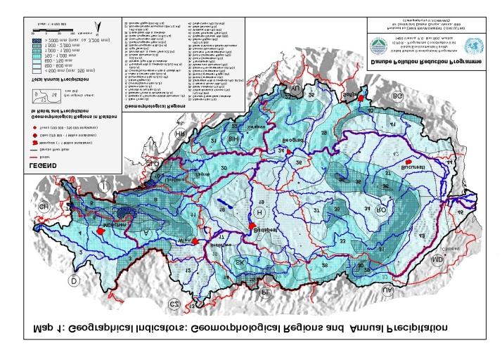
11 1. Introduction The following Thematic Maps of the Danube River Basin Report tries to give an overview of a proposed new sub-division developed for the PRP-Transboundary Analysis. This Report uses information from the National Reviews, adding socio-economic and ecological information, results from Water Quality Data and National Planning Reports (1998) and from questionnaires (landuse, agriculture, population, river characteristics), circulated in February and June In a new planning approach, the entire Danube Basin was nationally sub-divided into so-called Sub-river Basin Areas, i.e. aggregated, geographical units of several similar hydrographic parts (basins of mostly the Danube s first-order tributaries); these were discussed and agreed at the National Planning Workshops. There are one to four of such Areas per country and 32 Sub-river Basin Areas altogether in the Danube basin, as shown on Map 3. This allows an easier approach for the national assessment of environmental problems and their solutions. A summary text briefly describes the character of each Sub-river Basin Area (national view), the Annex further gives comparative charts for each Danube basin country and its Sub-river Basin Areas, regarding the following socio-economic issues: Population Density (excluding the main cities): Map 4 Land Use: Map 5 Agriculture (lifestock, fertiliser consumption and production of three main crops): Maps 6 and 7. Hot Spots: Maps 8 and 9 In a second step, these areas were looked at from a transboundary perspective and further aggregated, resulting in 15 mostly transboundary - Sub-River Basins which were discussed and agreed at the Transboundary Workshop in Hernstein (Map 2). Objective was to better address local and national river basin management needs at the Danube basin level; as stipulated i.a. by the new EU Water Policy Directive (asking for transboundary river basin districts ). This was achieved by reducing their number and by connecting transboundary hydrographic regions (e.g. catchment areas). The text chapter Sub-River Basins briefly describes the new aggregated regions (basic geographical and typical landscape characteristics, climate, most important economic data and environmental problems). The third step was the identification of Significant Impact Areas which are most intensively affected by pollution and which are valuable from an environmental and/or conservation point of view. This report lists and describes all 51 SIAs. The overlay of Hot Spots, SIAs and Wetlands (Maps 10 and 11) facilitated the needed selection and ranking of pollution reduction projects within the PRP. In a fourth step, Geomorphological Regions (Map 1) and Major Hydraulic Structures of Danube Basin Rivers (Map 12) were identified. There are some differences in the information given which should be briefly addressed before: Especially for the theme Land Use (Map 5), the provided data proved to be insufficient to cover the needed level of Sub-river Basin Areas. Therefore, the data given in this report are based on the CORINE geographical information system and may vary in a small degree from the national data given in some of the National Reports or the questionaires. For Agriculture (see maps 6 and 7), it was agreed with the Danube PCU to concentrate on few indicators (absolute and relative values for lifestocks and fertiliser consumption, the three main agricultural products). Due to the difference in detail information, only national data were compared.
12 2 Danube Pollution Reduction Programme The national data reports from Germany, Austria and Hungary did not follow the same methods to define geographical Sub-river Basin Areas (Germany and Hungary referred to their administrative structure, and Austria did not present any Sub-river Basin Area), so they related their data differently. In addition, the German and Austrian reports do not contain the same volume of information as the other national reports (e.g. much less detailed data; no Hot Spots - later sources of pollution were indicated). The text on Significant Impact Areas gives a more specific information on each of the SIAs, i.e. on the local character of the area, the pollution sources (Hot Spots) and effects. Many SIAs are linked or even overlap with Priority Wetlands for Restoration (see Map 10). The latter are described in a separate report produced by WWF. Tables presenting the results from working groups of the Transboundary Workshop are given in the annex. So far, 51 SIAs were identified, some of them were reviewed after Hernstein in their name and size (regrouping of adjacent SIAs). The overlay of Hot Spots, SIAs and Wetlands is given on Map 11 and allows from a basin-wide perspective the better identification of Danube regions of future concern. In Map 1, Geographical Indicators: Geomorphical Regions and Annual Precipition, the Danube basin was subdivided into 45 different geographical areas. Their outline is based on various geographical and national PRP information, including the Atlas of Danube Countries. Map 12 on Major Hydraulic Structures and Description of Rivers in the Danube Basin is based on another questionnaire and further research. As the time for replying was very short and the availability of data on national level differs in the region, the data sets and comparability of information is limited. It should be emphasized that such an overview did not exist so far for the Danube Basin.
13 2. Climate, Morphology and Hydrological Network Both the geography and the management of the Danube River Basin are dominated by the natural hierarchy of the Danube s hydrological network. Map 1 showing the Geomorphological Regions and Map 2 presenting, as a result of the PRP Transboundary Workshops, the Sub-river Basins reflect and respect this natural order. A detail description of each of the 15 Sub-river basins is given in chapter Geomorphological Regions The geography of the Danube river basin is very diverse. It includes high mountain chains, large plains, sand dunes, large forested or marshy wetlands and, very specifically, the karst and the delta. Similarly, climate and precipitation vary significantly; and they continuously form the basin s landscapes. Generally, the Danube basin is dominated by a continental climate (central and eastern regions). Only the western parts of the upper basin in Germany are influenced by the Atlantic climate and the south-west of the basin (ex-yugoslavian countries) by mediterranean climate. The Alps in the west, the Dinaric-Balkan mountain chains in the south and the Carpathian mountain bow in the eastern center are distinctive morphological and climatic regions and barriers. These mountain chains receive the highest annual precipitation (1,000-3,200 mm per year) while the inner and outer basins (Vienna basin, Pannonian basin, Romanian and Prut low plains), the uplands of the Czech Morava and the delta region are very dry ( mm per year). The rivers with their water and moisture from the wet mountains help to balance evapotranspiration deficits, typical for the Pannonian plain and the delta, in the dry lowlands. 50 to 70 days of annual snowfall are recorded at high elevations in the Alps and in the Carpathians, while the plains have just 1-3 days/year of snowfall. In terms of geomorphology and annual precipitation, 45 regions in the Danube basin can be distinguished, as presented in map 1 ( Geographical Indicators ). After the source of the Danube in the wet Black Forest, rainfall gradually increases from the west to the east, along the Swabian & Frankonian Middle Mountains (average precipitation mm/year), the Bavarian Forest & Austrian Mühlviertel (over 1,000 mm). There are each 4 prealpine and alpine regions, with top rainfalls reaching more than 2,000 mm/year at the Arlberg and the Kitzbühel and Julian Alps. Downstream the Wachau canyon (Bohemian mountains), the Danube enters the Vienna basin which is, together with the Moravian hills and lowlands, the driest area (below 600 mm/yr) of the Upper Danube. The middle part or heart of the Danube Basin is a circle of mountain chains around the huge Pannonian plain in the center. It is composed of six regions including parts of Austria, Slovakia, Hungary, Romania, Croatia and Yugoslavia. This inner basin is filled with Miocene marine sediments, tertiary clays and sands as well as with pleistocene fluvio-glacial and loess deposits. This results in little variation in the orography (hilly lands and the Danube and Tisza low plains) and in precipitation ( mm/year). The Carpathian mountains in the northern and the central-eastern parts of the Danube basin receive varying rainfall from 750 mm in the foothills to over 1,500 mm in the ridges, and have quite cold winters (average temperature in January 8 to 10 C). The ridges of the Tatra, the Wood Carpathians and the Southern Carpathians receive highest precipitation (over 2,000 mm/year around the highest peaks at over 2,500 m). The Transilvanian tableland is a dry upland ( mm) in between the moist Apuseni mountains (over 1,000 mm) in the west and the Eastern and the Southern Carpathians (upper reaches of Mures and Olt rivers).
14 4 Danube Pollution Reduction Programme Table 1 Geomorphological Regions Geomorphological Region Annual Precipitation (mm/year) Example Station (average data for the period ) Countries touching the region 1. Black Forest 1,000-1,500 D 2. Swabian & Frankonian Middle D Mountains 3. Bavarian Forest & Mühlviertel 1,000-1,500 D A 4. Foothills of the Alps 750 1,000 D A 5. Eastern Alps 1,000 1,500 A D 6. Central Eastern Alps 1,500-2,000 A D 7. Alpine Ridges over 2,000 A 8. South-Eastern Alps 1,000-1,500 Zagreb (163m): 870 A SLO HR mm 9. Julian & Carnian Alps over 2000 SLO A 10. Central South-Eastern Alps & 1,500-2,000 SLO A Kapela Mountains 11. Pre-Alpine Hills 750-1,000 A SLO HR H 12. Morava - Dyje Hills & CZ SK A Lowlands 13. Sudete Mountains CZ 14. Beskide Mountains & Lower 750 1,000 CZ SK Tatra 15. High Tatra 1,500 2,000 SK 16. Slovak - Hungarian Hills SK H 17. Small Hungarian Plain H SK 18. Inner Pannonian Hills Vienna (202m): 670 H A mm 19. Great Hungarian Plain Budapest(130m): 650 H RO YU mm 20. Drava - Sava Hills 750 1,000 HR H BIH YU 21. Bosnian - Serbian Mountains 750 1,000 Sarajevo (637m): 880 BIH YU HR mm 22. Bosnian Ridge 1,000 1,500 BIH HR YU 23. Albanian Alps 1,500 2,000 YU 24. Danube - Drava - Sava Belgrade (138m): 690 YU HR BIH Lowlands mm 25. Velika Morava & Kosovo YU 26. Banat Lowlands YU RO 27. Crisana & Mures Hills RO 28. Zakarpate Hills 750 1,000 RO UA SK 29. Wood Carpathians 1,000 1,500 UA 30. Wood Carpathian Ridge 1,500 2,000 UA 31. Eastern Carpathians 1,000 1,500 RO
15 Thematic Maps of the Danube River Basin June Table 1 continued 32. Eastern Pre-Carpathians 750 1,000 UA RO 33. Maramures Mountains 750 1,000 RO 34. Transilvania RO 35. South Carpathians 1,000 1,500 RO 36. South Carpathian Ridges 1,500 2,000 RO 37. Southern Pre-Carpathians 750 1,000 RO 38. Apuseni Mountains 1,000 1,500 RO 39. Banat & Western Balkan 750 1,000 Sofia (588m): 650 mm RO YU BG Mountains 40. Balkan Ridges 1,000 1,500 BG 41. Bulgarian Danube Hills BG 42. Great Romanian Plain Bucarest (82m): 650 RO mm 43. Moldova Hills RO MD 44. Balta Danube Below 500 RO 45. Delta - Liman Below 500 Sulina (9m): 505 mm RO UA MD The Dinaric Mountains form the borderline of the south-eastern Danube basin which is under mediterranean (southern Sava tributaries) and continental influence (Drava-Mura lowlands). Precipitation is over 1,000 mm along the Slovene-Croatian border, along the Bosnian mountain ridges and the Albanian Alps, and goes down below 700 mm in the Danube/Pannonian plains. The Southern Morava valley (Serbia/Kosovo) is a relatively dry, north-south directed barrier (average rainfall at 700 mm, evapo-transpiration at 550 mm) between the Bosnian mountains and the Banat/Western Balkan mountains. The moist Balkan mountain ridges form the southern borderline of the lower Danube and supply water for the relatively hot and dry Bulgarian hills and lowlands. East of the Carpathians, the huge plain of the Romanian Lowlands and the Moldova hills are subject to a temperate-continental dry climate along the lower Danube resp. the Siret and Prut rivers. The lowlands around the Balta Danube, the liman lakes and the Danube delta receive an annual precipitation of partly less than 400mm/year. Frequent droughts and a very high evapotranspiration are balanced by riverine moisture (high groundwater, network of islands and lakes, floodplains).
16
17
18
19 Thematic Maps of the Danube River Basin June Hydrological Network The Danube river basin can be divided into four parts: the Upper Danube, from its source to the confluence with the river Morava at Bratislava; the Middle Danube, ranging from Bratislava to the Iron Gate dams (Romania-Yugoslavia); the Lower Danube is formed by the Romanian-Bulgarian lowlands, and finally, the fourth part, the Danube Delta. The main tributaries of the Danube are listed in Table The most important Sub-River Basins of the Danube are: The Inn is only the sixth largest and seventh longest Danube tributary. At its mouth in Passau, it brings more water into the Danube than the latter itself. However, its catchment area of 26,130 km² is only nearly half as big than the Danube at this point. Main Inn tributary is the Salzach. The Drava is the third largest and fourth longest Danube tributary. It rises in the southern Alps in Italy but is the dominant river of southern Austria, eastern Slovenia and Croatia. Main Austrian sub-tributaries are Isel, Möll, Lieser and Gurk, and the Mura with its mouth at the Croatian- Hungarian border. The Sava river is the largest Danube tributary (av. 1,513 m³/sec) and the second by catchment area. It rises in the western Slovenian mountains and passes through Croatian lowland before forming the border between Croatia and Bosnia Herzegovina. Its main sub-tributaries are Ljubljanica, Kupa, Una, Vrbas, Bosna and Drina. The Tisza river is the longest (966 km) and by catchment ( km 2 ) the biggest tributary of the Danube river. Its flow volume is second after the Sava river. Its main sub-tributaries are Hornad, Bodrog, Slana and Bodva in Slovakia; Rica, Teresva, Tereblia, Borjava, Latoritsa and Uz in Ukraine; Somes, Crisul Repede, Crisul Alb, Mures, Timis, Bega in Romania; Tarna, Koros, Krasna, Szamos, and Maros in Hungary. The Siret river basin is situated in the eastern part of the basin and of the Carpathians. It has the third-largest catchment area. Main sub-tributaries are Suceava, Moldova, Bistrita, Trotus and Buzaul. The Prut river is the last tributary of the Danube and its second longest (950 km), with its mouth just upstream the delta. Its source is in the Ukrainian Wood Carpathians. Main sub-tributaries are Ceremus, Volovat, Baseu, Corogea, Jijia, Chinej, Cigur and Lapusna. The Danube Delta is largely situated in Romania and partly in Ukraine. The entire protected area covers 679,000 ha including floodplains and marine areas. The core of the reserve (312,400 ha) has been established as a "World Nature Heritage" in The Delta has a channel network of 3,463 km, with a density of 1.03 km/km². The highest density of channels is between the arms Chilia and Sulina, 1,17 km/km², while between Sulina and Sf. Gheorghe their density is only 0.71 km/km². There are 668 natural lakes larger than one hectare and with 9,28 % of the Delta s surface. The Delta is an environmental buffer between the Danube River and the Black Sea, filtering out pollutants and permitting both water quality conditions and natural habitats for fish in the Delta and in the environmentally vulnerable shallow waters of the north-western Black Sea. Moreover, it is Europe s largest remaining natural wetland, with unique ecosystems with extensive reed beds, forests, sand dunes and grasslands. It is home to several rare bird species, an important resting point for migrating birds, rich in fish and in an unusual flora.
20 10 Danube Pollution Reduction Programme Table 2 The main Danube tributaries, their length, catchment area and flows River Mouth at Danube km Length in km Size of Sub-basin in km² (larger than 4,000 km²) Flow m³/sec Min Max Average Lech 2, , Naab 2, , Isar 2, , Inn 2, , Traun 2, , Enns 2, , Morava (CZ) 1, , Raba 1, , Vah 1, , Hron 1, , Ipel 1, , Sio 1, , Drava 1, , Tisza 1, , , Sava 1, ,590 1,022 2,560 1,513 Morava (YU) 1, , Timok , Jiul , Iskar , Olt , Yantra , Arges , Ialomita , Siret , Prut , The river s runoff highly depends on the altitude zones and varies in a broad range: average yearly runoff compared to dry years varies from 1:8-1:16. The river network of the Danube Basin and of the Sub-river Basins are shown on Map 2.
21 Map 2: Sub-river Basins Based on Transboundary Analysis Workshop 1999 CZ PL UA 4 CH LEGEND D Border Danube River Basin Sub-river Basins Metropolis ( > 1 Million Inhabitants) Cities ( Million Inhabitants) Towns ( Inhabitants) Sub-river Basins 1: Upper Danube (D,A) 2: Inn (A,D) 3: Austrian Danube (A) 4: Morava (CZ,A,SK) 5: Váh - Hron (SK,CZ,H) 6. Pannonian Central Danube (A,SK,H,HR,YU) 7: Drava - Mura (A,SLO,HR,H) 8: Sava (SLO,HR,BIH,YU) 9: Tisa (SK,UA,RO,H,YU) 10: Banat - Eastern Serbia (YU,RO) 11: Velika Morava (YU,BG) 12: Mizia - Dobrudzha (BG) 13: Muntenia (R0) 14: Prut - Siret (UA,MD,RO) 15: Delta - Liman (MD,UA,RO) Kilometers Scale: 1: I 2 München N 3 7 SLO Wien A Ljubljana HR Brno Bratislava Budapest 6 SK Zagreb 8 Sarajevo 5 BIH H 9 Beograd YU Sofija RO BG 14 Bucuresti MD Chisinau Danube Pollution Reduction Programme United Nations Development Programme Global Environmental Facility ICPDR - Programme Coordination Unit 1400 Vienna, P.O. Box 500, Austria 15 Produced by ZINKE ENVIRONMENT CONSULTING for Central and Eastern Europe, Vienna, 1999 (Cartography by U.SCHWARZ)
22
23 3. Danube Sub-river Basin Areas (National Workshop Information) The list and description of Danube Sub-river Basin Areas is based on the results of National Planning Workshop Reports which were produced after respective national workshops in 11 countries in Additional natopnal information was provided by Germany and Austria. The following national summary texts briefly describe the character of each of the 32 Sub-river Basin Areas, shown on Map 3. In the following Maps 3 to 8 and in the Annex, further detail national information is given in comparative charts for each Danube basin country and for its Subriver Basin Areas, regarding the following socio-economic issues: Population Density (excluding the main cities): Map 4 Land Use: Map 5 Agriculture: Maps 6 and 7 Hot Spots: Maps 8. Table 3 National Sub-river Basins 1. Baden-Württemberg Sub-river Basin Area (D) 2. Bavaria Sub-river Basin Area (D) 3. Austria Sub-river Basin Area (A) 3.1. Inn Sub-basin Area 3.2. Austrian Danube Sub-basin Area 3.3. Pannonian Central Danube Sub-basin Area 3.4. Drava-Mura-Sub-basin Area 4. Morava Sub-river Basin Area (CZ) 5. Morava Danube Sub-river Basin Area (SK) 6. Váh Sub-river Basin Area (SK) 7. Hron Sub-river Basin Area (SK) 8. Bodrog Hornad Sub-river Basin Area (SK) 9. Danube-Drava Sub-river Basin Area (H) 10. Tisza Sub-river Basin Area (H) 11. Mura Sub-river Basin Area (SLO) 12. Danube Drava Sub-river Basin Area (HR) 13. Sava Sub-river Basin Area (HR) 14. Sava Sub-river Basin Area (B-H) 15. Danube Corridor Sub-river Basin Area (YU) 16. Tisa Sub-river Basin Area (YU) 17. Sava Sub-river Basin Area (YU) 18. Velika Morava Sub-river Basin Area (YU) 19. Western Region Sub-river Basin Area (BG) 20. Central Region Sub-river Basin Area (BG) 21. Eastern Region Sub-river Basin Area (BG) 22. Transilvania Sub-river Basin Area (RO) 23. Muntenia Sub-river Basin Area (RO) 24. Moldova Sub-river Basin Area (RO)
24 14 Danube Pollution Reduction Programme Table 3 continued 25. Upper Prut Sub-river Basin Area (MD) 26. Lower Prut Sub-river Basin Area (MD) 27. Yalpugh and Cahul Sub-river Basin Area (MD) 28. Transcarpathian Sub-river Basin Area (UA) 29. Prut Sub-river Basin Area (UA) 30. Lower Danube Sub-river Basin Area (UA) Table 4 Cities with a Population over 100,000 Inhabitants within the Danube River Basin Country City Number of Inhabitants Germany München 1,225,809 Augsburg 258,000 Regensburg 125,000 Ulm 115,000 Ingolstadt 113,000 Austria Wien 1, Graz 240,000 Linz 190,000 Salzburg 145,000 Czech Republic Brno 387,642 Olomouc 105,000 Slovakia Bratislava 451,581 Kosice 240,390 Hungary Budapest 1,886,215 Debrecen 208,449 Miskolc 177,495 Szeged 166,156 Pecs 161,156 Györ 127,429 Nyiregyhaza 113,489 Szekesfehervar 106,772 Slovenia Ljubljana 263,033 Maribor 98,811 (1992: 103,961) Croatia Zagreb 706,770 (1991) Osijek 104,761 (1991) Bosnia & Herzegovina Sarajevo 437,038 Banja Luka 240,000 (expected) Zenica 145,517 Tuzla 131,513 Prijedor 120,000 (expected) Doboj 110,000 (expected)
25 Thematic Maps of the Danube River Basin June Table 4 continued Federal Republic of Yugoslavia Beograd 1,602,226 (1991 data) Novi Sad 265,464 Nis 248,086 Pristina 199,645 Kragujevac 180,084 Leskovac 161,986 Subotica 150,534 Krusevac 138,111 Zrenjanin 136,778 Sabac 133,633 Pancevo 125,261 Kraljevo 125,772 Cacak 116,808 Smederevo 115,617 Kosovska Mitrovica 104,885 Gnjilane 103,000 Bulgaria Sofia 1,112,847 Rousse 167,352 Pleven 123,550 Dobrich 101,760 Romania Bucuresti 2,054,079 Iasi 343,330 Timisoara 333,049 Cluj-Napoca 330,943 Galati 328,058 Brasov 322,977 Craiova 308,031 Ploiesti 254,386 Braila 236,197 Oradea 222,994 Bacau 208,519 Arad 187,286 Pitesti 185,636 Sibiu 170,139 Targu Mures 166,972 Baia Mare 150,201 Buzau 149,524 Satu Mare 131,077 Botosani 129,099 Piatra Neamt 126,569 Ramnicu Valcea 118,877 Dobreta Turnu Severin 118,816 Ukraine Chernivtsi 261,200 Uzhgorod 124,900 Sources: Questionnaires of Danube-basin countries: all data are for 1996, except for figures given in brackets.
26
27 Map 3: Sub-river Basin Areas Based on National Planning Workshop Reports 1998 CZ PL UA CH D LEGEND 1 Border Danube River Basin Sub-river Basin Areas Sub-river Basin Areas 1: Baden-Württemberg (D) 2: Bayern (D) 3: Austria (A) 4: Morava (CZ) 5: Morava/Danube (SK) 6: Váh/Nitra (SK) 7: Hron/Ipel/Slaná (SK) 8: Hornád/Bodrog/Bodva (SK) 9: Danube/Drava (H)* 10: Tisa (H)* 11: Sava (SLO) 12: Drava (SLO) 13: Mura (SLO) 14: Drava/Danube (HR) 15: Sava (HR) 16: Sava (BIH) 13 Metropolis ( > 1 Million Inhabitants) Cities ( Million Inhabitants) Towns ( Inhabitants) 17: Danube (YU) 18: Tis a (YU) 19: Sava (YU) 20: Velica Morava (YU) 21: Western Region (BG) 22: Central Region (BG) 23: Eastern Region (BG) 24: Transsilvania RO) 25: Muntenia (RO) 26: Moldova (RO) 27: Upper Prut (MD) 28: Lower Prut (MD) 29: Yalpogh/Cahul (MD) 30: Transcarpathia (Tisa) (UA) 31: Upper Prut (UA) 32: Danube (UA) * not matching with the natural catchment areas of Danube/ Tisa rivers Kilometers N I 2 München 3 Brno 5 Bratislava Wien A 12 Ljubljana 11 SLO HR 4 13 Zagreb SK Budapest Sarajevo BIH H Beograd 20 YU Sofija RO 22 BG Bucuresti MD 23 Chisinau Danube Pollution Reduction Programme 28 United Nations Development Programme Global Environmental Facility ICPDR - Programme Coordination Unit 1400 Vienna, P.O. Box 500, Austria Scale: 1: Produced by ZINKE ENVIRONMENT CONSULTING for Central and Eastern Europe, Vienna, 1999 (Cartography by U.SCHWARZ)
28
29 Map 4: Population Density in the Danube Sub-river Basin Areas Based on N ational P lanning W o rkshop Reports 1998 CZ P L U A CH D I Mün chen A SLO Wien Ljubljana Zagreb Brno S K Bratislava Budapest H RO MD Bu curesti Chisinau LEGEN D Border Metropolis ( > 1 Million Inhabitants) Danube River Basin Metropols (> 1 Cities Mio Inhabi (250 tant 000 s) - 1 Million Inhabitants) HR Sarajevo Beograd Citys ( Mio I nhabi tants) Sub-river Basin Areas Towns ( Inhabitants) Towns ( I nhabitant s) Population Density (rural population wthout cities over inhabitants!) BIH Sofija B G In h abitan ts/k m² In h /km ² In h /km ² In h/km ² In h/km ² In h/km ² Kilome ters Scale: 1: N YU Danube Pollution Reduction Programme United Nations D evelopme nt Programme Global Environme ntal Fa cilit y IC PDR - Programme Coordina tion U nit 1400 Vienn a, P.O. Box 50 0, Austria Produced by ZINKE ENVIRONMENT CONSULTING for Central and Eastern Europe, Vienna, 1999 (Cartography by U.SCHWARZ)
30
31 # Map 5: Land Use in the Danube Sub-river Basin Areas Based on CORINE Land Use Data, National Planning Workshop Reports 1998 and Updates May 1999 CH LEGEND D Border Danube River Basin and Sub-river Basin Areas Metropolis ( > 1 Million Inhabitants) Cities ( Million Inhabitants) Towns ( Inhabitants) 14 Vineyards/ Orchards 40% 47% Land Use: Waters/ Wetlands Not classified Settlements Meadows/ Pastures 10% Scale: 1: % I Forest 30% (example figures) 28% Arable Land Only national data are shown from: A, SLO, YU, UA. No data were received from MD, HR. For some countries, 2 or 3 Sub-ri ver Basin Areas were identi fied in the National Planning Workshops Kilometers N 35% CZ 31% 40% A SLO 24% 25% 15% 18% 52% HR 39% Wien 48% 49% 23% 64% SK 10% 51% 46% 6% 26% 21% 46% 47% 48% Budapest 23% 45% PL 45% 19% 13% 14% 65% H 18% 44% BIH YU 30% 40% 19% 22% Sofija 49% 53% 51% 50% 31% UA 4% 31% 46% BG 6% 32% 42% MD 40% Chisinau RO 63% Danube Pollution Reduction Programme 19% United Nations Development Programme Global Environmental Facility ICPDR - Programme Coordination Unit 1400 Vienna, P.O. Box 500, Austria Produced by ZINKE ENVIRONMENT CONSULTING for Central and Eastern Europe, Vienna, 1999 (Cartography by U.SCHWARZ)
32
33 Map 6: Agricultural Indicators I (Lifestock/Fertiliser) in the Danube Basin Countries Based on National Planning Workshop Reports 1998 CZ Cattle Pigs CH LEGEND Border Danube River Basin D N78 P25 Border Danube River Basin Metropolis ( > 1 Million Inhabitants) Cities ( Million Inhabitants) Towns ( Inhabitants) München Total Lifestock/km² agricult. land Cattle Pigs I A N36 N61 P Cattle Pigs Bratislava Wien SK N 32 P15 P21 N41 SLO P17 Cattle Pigs HR Cattle Pigs N5 P2 H 13 3 Cattle Pigs Cattle Pigs Cattle Pigs BIH PL Budapest N14 P3 Sarajevo N33 P 9 Beograd Cattle Pigs Cattle Pigs YU N52 P Cattle Pigs N18 P10 Sofija N16 P Cattle Pigs UA N25 P2 BG RO Bucuresti Cattle Pigs Cattle Pigs N19 MD P16 Fertiliser in: kg/ha agricult. land/y N33 P Kilometers Scale: 1: N: Nitrogen P: Phosphate N Danube Pollution Reduction Programme United Nations Development Programme Global Environmental Facility ICPDR - Programme Coordination Unit 1400 Vienna, P.O. Box 500, Austria Produced by ZINKE ENVIRONMENT CONSULTING for Central and Eastern Europe, Vienna, 1999 (Cartography by U.SCHWARZ)
34
35 Map 7: Agricultural Indicators II (Total Lifestock, Total Fertiliser per Country) Based on National Planning Workshop Reports 1998 CZ Cattle Pigs CH LEGEND Border Danube River Basin D N*219 Metropolis ( > 1 Million Inhabitants) Cities ( Million Inhabitants) Towns ( Inhabitants) P*70 München Total Lifestock in 10,000 per Country Cattle Pigs Fertiliser in 1,000 t N(P)/y/Country N*56 P*15 I N: Nitrogen P: Phosphate (N*,P*: inorganic N**,P**: organic) Kilometers Scale: 1: N A N* 29 N** 28 P*10 P** Cattle Pigs SLO N*56 P* 15 N* 113 P* Cattle Pigs Wien HR Cattle Pigs Cattle Pigs Bratislava SK N*2 N* 203 N** 30 P* 15 P** Cattle Pigs Cattle Pigs BIH PL Sarajevo N* 74 P* 20 Budapest H Beograd Cattle Pigs Cattle Pigs YU N* 115 N**100 P*5 P** Cattle Pigs N*208 N**45 P*89 P**2 Sofija Cattle Pigs UA N* 165 P*9 BG RO Bucuresti Cattle Pigs MD Chisinau Danube Pollution Reduction Programme United Nations Development Programme Global Environmental Facility ICPDR - Programme Coordination Unit 1400 Vienna, P.O. Box 500, Austria Produced by ZINKE ENVIRONMENT CONSULTING for Central and Eastern Europe, Vienna, 1999 (Cartography by U.SCHWARZ)
36
37 Map 8: Hot Spots in the Danube Basin Countries Based on National Planning Workshop Reports 1998, Updates March 1999 CH LEGEND D Type: Municipal (Mun) Industrial (Ind) Agricultural (Agr) I Border Danube River Basin Hot Spots in the Countries 8 2 Mun Ind # München Mun Hot Spot Ranking: High Priority (HP) Medium Priority (MP) Low Priority (LP) Mun Metropolis ( > 1 Million Inhabitants) Cities ( Million Inhabitants) Towns ( Inhabitants) CZ 4 2 MunInd Ind Ind Agr Agr SLO Wien HR A Brno Mun Mun Mun Bratislava Mun Ind Ind # Budapest Agr Sarajevo # Agr PL Ind Ind BIH 9 Agr SK H Mun Beograd YU 9 6 Ind # 3 2 Mun Mun Agr 1 2 Ind 26 Sofija 2 Agr 26 # # # Ind 70 # UA # Agr Mun BG # # Ind RO Mun Bucuresti # Ind Agr Chisinau MD Mun Ind Kilometers Scale: 1: Agr (Count) N Danube Pollution Reduction Programme United Nations Development Programme Global Environmental Facility ICPDR - Programme Coordination Unit 1400 Vienna, P.O. Box 500, Austria Produced by ZINKE ENVIRONMENT CONSULTING for Central and Eastern Europe, Vienna, 1999 (Cartography by U.SCHWARZ)
38
39 Thematic Maps of the Danube River Basin June Germany The Danube rises at the confluence of the two source-rivers Brigach and Breg near Donaueschingen in the Black Forest in the German province of Baden-Württemberg, and continues through Bavaria towards the Austrian border. The length of the Danube in Germany is some 580 kilometres. The flow regime is both of mountaineous (upper section and northern tributaries) and alpine character (lowest section and southern tributaries). Precipitation data in the German Danube-basin Area are between 600 and 1,500 mm/year growing steadily with the altitude of the Alps (average value at 1,000 mm per year). Along the river, the are more than 20 small nature reserves; the Upper Danube Valley is a nature park (857 km²), the mouth of the Isar river is a floodplain reserve of national importance. Two national parks exist in upper parts of the Regen and of the Salzach rivers (Bavarian Forest resp. Berchtesgaden). The German part of the Danube Basin was nationally divided into two Sub-river Basin Areas, corresponding to the administrative borders of the two provinces of Baden-Württemberg and Bavaria. It represents 56,240 km² of the state territory of Germany. With a population of 9.1 million and an average density of 131 people/km² (without cities with a population over 100,000), the region is rather intensively developed and densely populated. River regulation in form of hydrodams and diffuse pollution, mainly due to intensive agriculture, resulting in a loss of natural buffer zones are the main water-related problems. For the Bavarian State Ministry for Environment it is important to establish, that there are no Hot Spots under the given UNDP/GEF criteria but sources of pollution. Ten such sources were identified (eight municipalities and two industrial). The German part of the river basin has borders with Austria and the Czech Republic. 1. Baden-Württemberg Sub-river Basin Area (D) With its 8,034 km² this area is much smaller than the Bavarian Sub-river Basin Area. The character of the Danube in this region is only partly near-natural (some wetlands and protected floodplain meadows) as almost of the entire stretch is impounded by small hydrodams. 52% of the area are under agricultural production. There are, except for Ulm, no major cities. This Area has no borders with other countries. 2. Bavaria Sub-river Basin Area (D) The Bavarian Sub-river Basin Area has a size of 48,206 km². Except for short sections, most of the Danube and its southern tributaries are impounded by chains of hydrodams. The Inn as the largest tributary of the Upper Danube has its mouth near the border with Austria. The Rhine-Main-Danube Canal as a major European navigation route ends ustream of Regensburg. Several big urban agglomerations like the cities of Munich (capital of Bavaria with a population far over 1 million people), Regensburg, Augsburg and Ingolstadt (each with more than 100,000 inhabitants) are located within the area. Total agricultural land is 24,000 km² (50%), composed of 14,000 km² of arable land and of 10,000 km² of meadows and pastures. The area has borders with Austria and Czech Republic.
40 30 Danube Pollution Reduction Programme 3.2. Austria 3. Austria Sub-river Basin Area Nearly the entire country area of Austria (80,853 km² = 96%) is part of the Danube River Basin. The Austrian National Reports do not indicate a sub-division of Sub-river Basin Areas within the national territory. A sub-division of 14 Austrian river sub-basins is given in the following table. In addition, at the TDA Workshop for a Transboundary Analysis (24-30 January in Hernstein), four Sub-river Basin Areas were identified for Austria: Inn, Austrian Danube (incl. Vienna), Drava - Mura and Pannonian - Central Danube. The state territory varies a lot: the western und central parts are a high alpine mountain region with 1,500 to over 2,500 mm of annual precipitation, while the eastern basins and plains east and north of Vienna receive only 500 to 600 mm. Forests and grasslands (cattle breeding and dairy production) dominate over arable lands. Governmental subsidy programmes for traditional, ecological farming have put Austria in the 1990s into the world s top position for eco-farming. While Austria has a share of some 10% of the entire Danube catchment area, it supplies about 25% of all Danube waters entering the Black Sea. Four of the main Danube tributaries (Traun, Enns, Ybbs and March/Morava) have their confluence in Austria, three (Inn, Drau/Drava and Mur/Mura) are transboundary rivers. The Danube (10 dams) as much as most tributaries are impounded by chains of hydrodams in their lower and middle sections; only small parts especially in the upstream reaches still show natural flow conditions. Most valuable floodplain areas are limited to the eastern and southern borders: the Danube downstream of Vienna (since 1996 national park area), the Lower March/Morava - Thaya/Dyje along the Czech and Slovak borders and the Mur/Mura along the Slovenian border. After subtracting the cities over 100,000 inhabitants (Vienna, Linz, Graz, Salzburg and Innsbruck), the population density in this Area is 64 inhabitants/km². As the Austrian water resources dilution capacity is very large and as the legal requirements for water protection and use are very stringent (partly beyond EU standards), Austria has listed only 4 medium municipal and two medium industrial Sources of Pollution. The potential to reduce overall pollution loads is more limited than in other parts of the Danube basin. The table in the Annex indicates the 14 hydrological sub-basins, as given by Austrian water authorities in their national data report, but allocated here to the four Sub-River Basins, as agreed for the Austrian territory at the Hernstein workshop.
41 Thematic Maps of the Danube River Basin June Czech Republic The Czech Republic s part of the Danube Basin has only one Sub-river Basin Area, corresponding to the sub-basin of the Morava river. This represents 27% (21,145 km²) of the state territory. 4. Morava Sub-river Basin Area (CZ) The length of the Morava in the country is 353 km. The altitude of the territory fluctuates between 148 and 1,491 metres above sea level. Average precipitation is 635 mm and fluctuates between 450 mm (Breclav) and 1,150 mm (Beskydy Mountains). Some 54% of the area are made up by agricultural land, forests cover 34%, 12% include urban areas and water-covered regions (many reservoirs). The area is affected by relatively high erosion, mainly caused by intensive agriculture. With a population over 2,78 Million people, the average population density in the Morava river sub-basin is 108 persons/km². 14% (390,000) of the population are concentrated in the largest city, Brno. The only other city over inhabitants is Olomouc (105,000). Industry is the main human activity impacting the environment. Mechanical Engineering and Chemical Production complemented by the processing of local resources in the food, leather and wood working industry and in the manufacturing of building materials are typical for the Morava river sub-basin. About 14% of the area is protected these areas are the most important part of regional and supraregional systems of ecological stability. There are three Ramsar Wetlands in the territory, including very valuable floodplain forests. All would be affected by the newly planned Danube-Oder-Elbe Canal, designed to provide a new major navigation route across the Morava valley. More than 50% of the Czech hydro-power capacity is concentrated in the Morava river sub-basin. The Danube-basin Area of the Czech Republic is a quite dry region. Within most of the region, yearly average precipitation lies between mm. In the lowlands - the most fertile part of the Czech Republic - five Agricultural Hot Spots were identified. Industrial wastewaters and solid wastes contribute an important part of wastewaters in the Sub-basin. All together three industrial and nine municipal Hot Spots were identified. The Sub-river Basin Areas has borders with Austria, Poland and Slovakia.
42 32 Danube Pollution Reduction Programme 3.4. Slovakia The Slovak part of the Danube Basin is divided into four Sub-river Basin Areas with ten Sub- Basins, representing nearly 96% (49,014 km²) of the total area of the Slovak Republic. The Slovak part of the River Basin has borders with Austria, Czechia, Poland, Ukraine and Hungary. 5. Morava - Danube Sub-river Basin Area (SK) This Sub-river Basin Area consists of the Morava, Danube and the Small Danube River sub-basins. With its 3,395 km², this is the smallest Sub-river Basin Area of the Slovak Republic. The two main rivers are the Danube and the Morava. The relief of the Morava mainly consists of lowlands and valleys; it includes some of the largest floodplain meadws in Central Europe. The region around the Small Danube (former side-arm) is most fertile, agricultural land. The Danube part includes large floodplain forests which, since 1992, are affected by the Gabcikovo hydropower complex. Without counting the capital Bratislava (451,000inhabitants), the density of 125 inhabitants/km² is still the highest in the country. With one medium and one low priority industrial hot spots, the region lies in the average of the Slovak Republic. The area has borders with the Czech Republic, Poland and Austria. 6. Váh Sub-river Basin Area (SK) The Váh Sub-river Basin Area is created by the two sub-basins of the Váh and Nitra rivers and is situated in the northeast of the country. The Váh River is situated in a mountainous area, characterised by a very low population density. The sub-basin represents one quarter of the total territory of Slovakia (biggest Sub-river Basin Area of Slovakia) and with its discharge of 152 m³/sec it is Slovakia s biggest river. Although the population rate is quite low in this region we find five municipal and two industrial hot spots. Industrial activities are represented with chemical, heavy and food-processing industries. This area has the highest rate of employment in the industrial sector. The Nitra River rises on the Southern slopes of Malá Fatra mountains (Small Carpathians) and confluences with the Vah River just before running into the Danube. The area has borders with the Czech Republic and Poland. 7. Hron Sub-river Basin Area (SK) This area is in the Southern part of central Slovakia and includes the Hron, Ipel and Slaná subbasins. The Hron River itself rises in the Slovenské Rudohorie mountains at an elevation of 934 meters and flows into the Danube River at 102 metres. The Hron Sub-river Basin Area is much more industrialised (mainly heavy industries) than the rivers Ipel and Slaná (32% urbanised) where agricultural production prevails. The Ipel river is affected by food industries. Three industrial Hot Spots ( low priority ) can be found along the Hron. The area has only borders with Hungary.
43 Thematic Maps of the Danube River Basin June Bodrog - Hornad Sub-river Basin Area (SK) This part of Slovakia lies in the East and has borders with Poland and the Ukraine. The Sub-river Basin Area contains the Bodrog, Hornad and Bodva rivers. This part of Slovakia includes the second-largest city, Kosice (240,000 inh.). The high population density especially in the Hronad sub-basin is connected with one high priority and three medium priority municipal hot spots. Agriculture is one of important pollution sources, mainly influencing the groundwater quality. The main industrial sectors are mining activities and oreprocessing. The Sub-basin has borders with Hungary.
44 34 Danube Pollution Reduction Programme 3.5. Hungary Hungary, located in the center of the Carpathian basin, belongs to a single watershed, the Danube, therefore representing 100% or 93,030 km² of the total area of the country. Different to other countries, the available Hungarian data are not based on a hydrographic subdivision but on an administrative structure of the country s 12 regional water directorates. For pragmatic reasons of this comparative report and to avoid a mixing with non-comparable data, the sub-division of the UNDP/GEF Report Part A for Hungary (Social and Economic Analysis in relation to Water Pollution) was used to get two Sub-river Basin Areas, with each six sub-basins (in this separation of the Tisza and the Danube-Drava areas, the hydrographic and administrative borders almost match). Hungary is the country of the whole Danube Basin with the lowest average precipitation: Within most parts of the country rainfall will not climb above 600mm per year. 9. Danube-Drava Sub-river Basin Area (H) The Sub-river Basin Area consists of the Drava and the Danube Rivers, covering 50,547km² (54,3%) of the country. It consists largely of the small Hungarian plain and the Hungarian low mountains. Internationally important wetlands are located along both the Danube (in the Szigetköz/NW Hungary affected by the Gabcikovo power plant - and in the Gemenc-Béda area in the South) and the Drava rivers (almost the entire borderline with Croatia). Without counting the cities over 100,000 inhabitants, still more than 4 million people live in this area, which corresponds to more than 81 people per km². Apart from the capital Budapest with a population of 2 million, there are another three cities in the category over 100,000 inhabitants. 25 municipal Hot Spots were identified in this area, four in the highest category. 15 Hot Spots were calculated for the industrial sector, two rated as High priority. Around the district capital Székesfehérvár, large chemical and aluminium industries are operating. In the lake Balaton region, tourism became the most important economical factor. The Sub-river Basin Area has borders with Austria, Slovakia, Croatia and Yugoslavia. 10. Tisza Sub-river Basin Area (H) The Sub-river Basin Area consists of the Tisza and covers 42,483 km² (45,7%) of the country. The area consists largely of the big Hungarian plain and a part of the Hungarian low mountains. The Tisza river with many largely intact floodplain habitats and the famous puszta pastures are partly affected by agricultural use. More than 2,9 million people (without the five cities with a population over 100,000) live in this area, which corresponds to more than 70 people per km². All together 12 Municipal and 11 Industrial Hot Spots were identified, Industrial with the majority ranked as Low priority. The north is considered as a socio-economic crisis area: The unemployment rate is above the national average, emigration is significant and existing manpower is poorly qualified. Also some large units of chemical industries are situated in this area. The Sub-river Basin Area has borders with Slovakia, Ukraine, Romania and Yugoslavia.
45 Thematic Maps of the Danube River Basin June Slovenia The Slovenian part (2%) of the Danube Basin is divided into three sub-basins and Sub-river Basin Areas, representing 81% (16,363 km²) of the total area of the country and hosting 80% of its population. The upper part of the watershed is on carbonaceous rocks, which makes 1/3 karstic underground watershed and 2/3 fluvial relief on gravel. Almost the entire part of the Danube river basin belongs to forest ecosystems (entire country: 53% and still increasing). Bio-climatically, the Danube river sub-basin is characterised by a transition from a humid climate (alpine and dynamic part of the river sub-basin plus the central part of the Sava river sub-basin) to a semi-humid and partially semi-arid climate of the Drava and Mura rivers. The Slovenian part of the Danube River Basin has borders with Italy, Austria, Hungary and Croatia. 11. Sava Sub-river Basin Area (SLO) Among the countries major rivers, only the Sava has its source in Slovenia. With 11,734 km², it is the biggest Sub-river Basin Area. It embraces the following landscape units: a high mountainous region (mainly karstic alpine area), an extensive, mainly karstic subalpine region with the basins of Ljubljana and Celje, and a minor part of the sub-pannonian world. The major wetland Ljubljanske Barje is near the capital, Cerknica lake (intermittent karstic) is protected. The population is over 1.2 million inhabitants (60% of the country, including the capital of Ljubljana) and the population density is at 77 people/km² (without the capital). Along the Sava River, 15 municipal and 6 industrial Hot Spots were identified. The Sub-basin has borders with Italy, Austria and Croatia. 12. Drava Sub-river Basin Area (SLO) The surface of the Drava river sub-basin, with the river originating in Austria, covers 3,253 km² or 16% of Slovenia. According to ecosystematic characteristics, the Slovenian part of the Drava river can be divided into the following parts: alpine and karst river basin, subalpine and non-karstic area of the smaller basins of Pohorje and Kozjak, subalpine and sub-pannonic river basins of Dravinjske, some smaller water stream river basins and the gravelled Drava-Ptuj field (groundwater area). The latter is a still very valuable river stretch and floodplain, even though it is affected by a river diversion. With 415,000 inhabitants (21% of the state) and a population density of over 74 people/km² (without Maribor), the area is under the Slovenian average. The most polluting industries are old lead mines and storage of used batteries, aluminium producing industries and pesticide factories. The Sub-river Basin Area has borders with Austria and Croatia. 13. Mura Sub-river Basin Area (SLO) With only 7% (1,376 km²) of the Slovenian territory, this Sub-river Basin Area is the smallest of this country. The river again rises in Austria. It comprises mainly agricultural sub-pannonian landscape ecosystems of plains and hills. Large stretches of the Mura are still very intact floodplain areas (border lines with Austria and Croatia) but endangered due to river bed erosion (Austrian dams). The population density in this part of Slovenia is above the average (87 people/km²), some human activities resulted in 3 municipal, 3 agricultural and one industrial Hot Spots all listed under "High priority". Growing tourism in this region has become a very important social-economical
The UNDP/GEF Danube Regional Project
 1 The UNDP/GEF Danube Regional Project Pilot River Basin Management Plan for the Sava River Sub-Basin Andy Garner Environmental Specialist Sava Initiative WG Meeting September 17-18, 2002 GEF Black Sea
Cooperation in the Danube River Basin
 Cooperation in the Danube River Basin Mr. Gyula Holló Head of Delegation, Hungary Ms. Jasmine Bachmann ICPDR Secretariat, Vienna 2 Content Facts and figures about the Danube River Basin International Commission
Danube River Basin District
 Danube River Basin District Part A - Roof report Information required according to Art. 3 (8) and Annex I of the EU Water Framework Directive Reporting deadline: June 22, 2004 Prepared by: International
ICPDR organisation and work in the field of accidental water pollution Examples of transboundary cooperation
 ICPDR organisation and work in the field of accidental water pollution Examples of transboundary cooperation Dr. Teodor Lucian Constantinescu, National Administration Romanian Waters, Bucharest, Romania
The Danube Experience
 The Danube Experience Dealing with Hydromorphological Issues the Danube Experience Philip Weller Executive Secretary, ICPDR Danube River Basin- Overview The Danube River Basin is the most international
3 NINE GEO-MORPHOLOGICAL DANUBE REACHES 3.1 Introduction. 3.2 Definition Procedure
 3 NINE GEO-MORPHOLOGICAL DANUBE REACHES 3.1 Introduction The Danube River is the second largest stream in Europe spanning between its source and its mouth in the Black Sea a total of 2,857 km and covering
Danube River Basin. a source for transboundary cooperation. Exploring the Results and Potential for Transboundary Water Management Cooperation
 Danube River Basin a source for transboundary cooperation Exploring the Results and Potential for Transboundary Water Management Cooperation Philip Weller ICPDR, Executive Secretary Joint Meeting EUWI
Danube River Basin District
 Danube River District Part B - Report 2003 ROMANIA Information required according to Art. 3 (8) and Annex I of the EU Water Framework Directive Reporting deadline: June 22, 2004 Prepared by National Administration
Transboundary River Management in the Danube Basin
 Southern Illinois University Carbondale OpenSIUC Key Note Presentation World River Day 2011 11-2011 Transboundary River Management in the Danube Basin Philip Weller International Commission for the Protection
Implementation of WFD in Serbia and Montenegro
 Ministry of Agriculture, Forestry and Water Management Directorate for Water Implementation of WFD in Serbia and Montenegro Nikola Marjanovic, PhD Civ. Eng. SERBIA AND MONTENEGRO SERBIA Area: 88.361 km
WATER MANAGEMENT IN ROMANIA. Elisabeta CSERWID National Institute of Hydrology and Water Management ROMANIA
 WATER MANAGEMENT IN ROMANIA Elisabeta CSERWID National Institute of Hydrology and Water Management ROMANIA 2 I - Water management in Romania Romania general information Location: S-E Europe Surface: 238,391
Presentation from 2015 World Water Week in Stockholm. The authors, all rights reserved. SIWI siwi.org
 Presentation from 2015 World Water Week in Stockholm www.worldwaterweek.org The authors, all rights reserved SIWI siwi.org WORLD WATER WEEK Stockholm, 23 th August 2015 Co-operative water governance: catalyst
SUPPORT TO WATER RESOURCES MANAGEMENT IN THE DRINA RIVER BASIN DRAFT ROOF REPORT INTRODUCTION AND GENERAL APPROACH
 SUPPORT TO WATER RESOURCES MANAGEMENT IN THE DRINA RIVER BASIN DRAFT ROOF REPORT INTRODUCTION AND GENERAL APPROACH Nadja Zeleznik, REC Public Concultation Beograd, Serbia, 4 July 2017 1 1. Introduction
Managing environmental risks in the Danube Region
 Environmental Risks Managing environmental risks in the Danube Region www.danubeenvironmentalrisks.eu INTRODUCTION The Danube Region represents one fifth of the European Union s total area and is home
Danube River Basin District
 Danube River Basin District Part B National Report BULGARIA Information required according to Art. 3 (8) and Annex I of the EU Water Framework Directive prepared by Ministry of Environment and Water 2
ICPDR FP-EG project overview
 ICPDR FP-EG project overview 9 th Steering Group meeting of PA5 of the EUSDR Management of Environmental Risks KÁROLY GOMBÁS CHAIRMAN FLOOD PROTECTION EXPERT GROUP (FP-EG) INTERNATONAL COMISSION OF THE
Actions to Narrow the Gap Between Transport Efficiency of the Danube Region Countries
 Actions to Narrow the Gap Between Transport Efficiency of the Danube Region Countries Miodrag Poledica, State Secretary and PAC Serbia Ministry of Construction, Transport and Infrastructure THE DANUBE
EUROPEAN UNION STRATEGY FOR THE DANUBE REGION EUSDR. Pillar II Protecting the Environment in the Danube Region
 EUROPEAN UNION STRATEGY FOR THE DANUBE REGION EUSDR Pillar II Protecting the Environment in the Danube Region Priority Area 6: Preserving biodiversity, landscapes and the quality of air and soils dr. Florian
Outline of the Danube River Basin District Management Plan
 Outline of the Danube River Basin District Management Plan Part A Basin-wide overview Report on the DRBM Plan and its Joint Programme of Measures to support the EU WFD public consultation process Document
Development of the Danube River Basin District Management Plan
 DRAFT-8 DOC-101 23-Nov-2005 Development of the Danube River Basin District Management Plan - Strategy for coordination in a large international river basin River Basin Management Expert Group Prepared
EU MACRO-REGIONAL STRATEGY FOR THE CARPATHIAN REGION. Gabriela Szuba Ministry of the Environment, Poland Modra, June 2017
 EU MACRO-REGIONAL STRATEGY FOR THE CARPATHIAN REGION Gabriela Szuba Ministry of the Environment, Poland Modra, 14-16 June 2017 EU MACRO-REGIONAL STRATEGY FOR THE CARPATHIAN REGION Overview Why EU macro-regional
The European Union Strategy for the Danube Region: climate and disaster risk reduction
 The European Union Strategy for the Danube Region: climate and disaster risk reduction Károly Gombás 16.11.2017, Budapest Project co-funded by European Union funds (ERDF) National and transboundary issues
CO-OPERATION IN DANUBE RIVER BASIN - THE ROLE OF SHMI SLOVENSKÝ HYDROMETEOROLOGICKÝ ÚSTAV
 CO-OPERATION IN DANUBE RIVER BASIN - THE ROLE OF SHMI WMO RAVI Hydrological Forum 2016 Oslo, 1 Danube, the 2nd longest in Europe. 2857 km Flows across 10 European states River basin - 817 000 km2 1/11
Implementation of the Water Convention, including its complementary role to the EU Water Framework Directive
 Implementation of the Water Convention, including its complementary role to the EU Water Framework Directive Experience of Serbia Dragana Milovanović Ministry of Agriculture, Forestry and Water Management
International Sava River Basin Commission - An example of EU/non EU country cooperation in water management
 International Sava River Basin Commission - An example of EU/non EU country cooperation in water management Improvement and co-operation possibilities in the water sector with non-eu countries Ulm, 29
Danube River Basin District
 16 th June 2004 Danube River Basin District Part B - Report 2003 REPUBLIC OF MOLDOVA Information required according to Art. 3 (8) and Annex I of the EU Water Framework Directive Reporting deadline: June
Cross border cooperation between Ukraine and Moldova: achievements, opportunities and problems DANUBE FINANCING AND CAPACITY BUILDING DIALOGUE
 Cross border cooperation between Ukraine and Moldova: achievements, opportunities and problems Igor Studennikov Executive Director Centre for Regional Studies, Odessa, Ukraine Member of the Executive Committee
Phase 1 opening July 2009 Phase 2 opening Summer 2010 ARAD ROMANIA
 Phase 1 opening July 2009 Phase 2 opening Summer 2010 ARAD ROMANIA HIGHLIGHTS Ice Plaza will be the first shopping centre in Arad, Romania, supporting a local population of 250,000 people and a catchment
International Sava River Basin Commission
 International Sava River Basin Commission Pilot project on climate change: Building the link between the Flood Risk Management planning and climate change assessment in the Sava River Basin climate change
Management of a Large The Danube. Mr. Mitja Bricelj ICPDR President Perth,13 October 2010
 Management of a Large International ti River Basin: The Danube Mr. Mitja Bricelj ICPDR President Perth,13 October 2010 From the Black Forest From the Black Forest to the Black Sea Human activities damaged
The Lower Prut Floodplain Natural Park (Romania)
") The Lower Prut Floodplain Natural Park (Romania) Gabriela Costea Natural Sciences Museum Complex Galati (Romania) & member of the Scientific Council of the Lower Prut Floodplain Natural Park The Prut The
The Lower Prut Floodplain Natural Park (Romania) Gabriela Costea Natural Sciences Museum Complex Galati (Romania) & member of the Scientific Council of the Lower Prut Floodplain Natural Park The Prut The
Danube River Basin District
 Ministry of Agriculture, Forestry and Water Management June 18 th, 2004 Danube River Basin District Part B - Report 2003 CROATIA Information required according to Art. 3 (8) and Annex I of the EU Water
Urbanisation and the Urban Network in South Eastern Europe
 Urbanisation and the Urban Network in South Eastern Europe The level of urbanisation in South Eastern Europe, particularly in the Balkan states is well below the level of urbanisation of Western Europe,
Flood Action Programme Action Programme for Sustainable Flood Protection in the Danube River Basin
 Flood Action Programme Action Programme for Sustainable Flood Protection in the Danube River Basin // / Deutschland //// Österreich //// Česká republika //// Slovensko //// Magyarország//// Slovenija ////
The Timok River Basin in Serbia
 The Timok River Basin in Serbia UNECE Workshop on Integrated Transboundary Water Resources Management in SEE, Sarajevo, 18-20 May, 2009 Dragana Ninković, Dipl.-Ing. Dušan Dobričić, Dipl.-Ing. Content 1.
Paper 87 - INTERNATIONAL COLLABORATION CONCERNING THE USE OF THE DANUBE RIVER IN ROMANIA
 Paper 87 - INTERNATIONAL COLLABORATION CONCERNING THE USE OF THE DANUBE RIVER IN ROMANIA CIORTAN R.; DUMITRU M.; SUCIU I.; KRKLJUS D. Ph.D, Corresponding Member of the Romanian Academy of Technical Sciences,
International Workshop on Flood Protection Education Network in the Danube River Basin
 26 May 2017 Dear Sir or Madame, We are pleased to invite you to the International Workshop on Flood Protection Education Network in the Danube River Basin organized by the Ministry of Foreign Affairs and
BIOREGIO Carpathians. Overview
 BIOREGIO Carpathians Overview Econnect Final Confernce Berchtesgaden, 26-28 September 2011 Mircea Verghelet Piatra Craiului Natinal Park 1 Integrated management of biological and landscape diversity for
Reality Consult GmbH
 Reality Consult GmbH International management consultancy for Real Estate and Facility Management Market Study 2014 Facility Management in Central and Eastern Europe, and in Bulgaria 2014-10-23 Peter Prischl,
ANNEX IV. Heavily Modified Surface Water Bodies in Serbia and Montenegro
 ANNEX IV Heavily Modified Surface Water Bodies in Serbia and Montenegro Annex IV Heavily Modified Surface Water Bodies in Serbia and Montenegro 1 (1) HMWB Danube Location location Code/abbreviation of
A spotlight on tourism in CEE. Christopher Hinteregger, 14 th May 2012, Vienna
 Christopher Hinteregger, 14 th May 2012, Vienna Table of Contents About Kohl & Partner Tourism in CEE a brief overview Key learnings from our projects 2 Who we are Independent and internationally operating
Danube Academies Scientific Support to the EUROPEAN DANUBE STRATEGY
 Danube Academies Scientific Support to the EUROPEAN DANUBE STRATEGY Cristian HERA Vice President of the Romanian Academy Bucharest, June 26, 2013 First Danube Academies Conference 11 September 2011, Vienna
Outline. The main objectives. The main objectives. Distribution of stable isotopes in the Sava River in Serbia
 Distribution of stable isotopes in the Sava River in Serbia N. MILJEVIĆ 1, D. GOLOBOČANIN 1, M. NADEŽDI DIĆ, N. OGRINC 3 1 Vinča a Institute of Nuclear Sciences, POB 5, 11001 Belgrade, Serbia Republic
The Isonzo/Soca river basin
 Geneva September 8 th 2014 The Isonzo/Soca river basin Status and perspective on the possible Alpine river basin to be assessed The Alpine Convention Water management, risk management and adaptation to
>> Improve accessibility of regions along the Danube along the river as well as from the river to the hinterland through sustainable mobility offers
 THE PEP Partnership EU European Territorial Cooperation Possibilities to develop projects to implement THE PEP TRANSDANUBE Sustainable Transport and Tourism along the Danube ACCESS2MOUNTAIN Sustainable
Transboundary Water Management in Republic of Macedonia
 12th International Conference EUROPE-INBO 2014 12-15 November 2014, Bucharest, Romania. Transboundary Water Management in Republic of Macedonia Ylber Mirta Head of Department for Waters ymirta@gmail.com
Croatia completes inventory of wetlands
 Croatia completes inventory of wetlands 16 October 2006 Croatia CRO-WET - Croatian Wetland Inventory SGF project completed The Croatian State Institute for Nature Protection (SINP) carried out a comprehensive
CH. 1 Europe and Russia: Physical Geography. Section 1 Land and Water p Europe and Russia are part of the world s largest landmass called.
 CH. 1 Europe and Russia: Physical Geography Section 1 Land and Water p.10-16 Europe and Russia are part of the world s largest landmass called. The country of Russia stretches over both continents. About
Scientific Support to the Danube Strategy
 Monday, 29 September 2014 CONCEPT PAPER Scientific Support to the Danube Strategy The of the European Commission is coordinating an initiative aiming to provide scientific support to the European Union
1. Title of your regional initiative: Carpathian Wetland Initiative (CWI)
") Regional Initiatives: Annual Summary Report 2009 and Plan for 2010 1. Title of your regional initiative: Carpathian Wetland Initiative (CWI) 2. Work and activities undertaken 2009 objectives activities
Regional Initiatives: Annual Summary Report 2009 and Plan for 2010 1. Title of your regional initiative: Carpathian Wetland Initiative (CWI) 2. Work and activities undertaken 2009 objectives activities
Sustainable Mobility in the Danube region From Coordination and Cooperation to Co-Action
 The EU Strategy for the Danube Region Priority Area 1b Sustainable Mobility in the Danube region From Coordination and Cooperation to Co-Action Franc Žepič, PAC 1b Ministry of Infrastructure, Slovenia
THE IMPLEMENTATION OF EWFD/WFD IN THE REGION OF VOJVODINA WITHIN JOINT SLOVAK-SERBIA SERBIA PROJECTS
 Towards Integrated River Basin Management The 55 th Anniversary of the Founding of the Water Research Institute THE IMPLEMENTATION OF EWFD/WFD IN THE REGION OF VOJVODINA WITHIN JOINT SLOVAK-SERBIA SERBIA
STATISTIČKI INFORMATOR BROJ 2. STATISTICAL BULLETIN
 CENTRE OF PUBLIC EMPLOYMENT SERVICES CENTAR OF SOUTHEAST JAVNIH SLUŽBI EUROPEAN ZA ZAPOŠLJAVANJE COUNTRIES ZEMALJA JUGOISTOČNE EVROPE STATISTIČKI INFORMATOR BROJ 2. STATISTICAL BULLETIN No. 2 JULI 2009.
Protected Landscape Area Danube Floodplains. State Nature Conservancy of the Slovak Republic
 Protected Landscape Area Danube Floodplains State Nature Conservancy of the Slovak Republic Logo SKHU project: Preparation Activities of the Szigetköz Žitný Ostrov Nature Park and Joint Nature Protection
Ministry of Communications and Transport
 more than 100,000 houses and other buildings in Bosnia and Herzegovina (May 2014) were no longer fit to use and that over a million people had been cut off from clean water supplies. Ministry of Communications
Outstanding Balkan River landscapes a basis for wise development decisions. Slovenia
 Outstanding Balkan River landscapes a basis for wise development decisions Slovenia Table of Contents: 1. Hydromorphological intactness of rivers 2 2. Protected areas, karst poljes, estuaries/deltas and
Nature Conservation and Regional Development in Floodplains and Wetlands in the Central and Lower Danube River Basin
 Nature Conservation and Regional Development in Floodplains and Wetlands in the Central and Lower Danube River Basin Project Manager: Dr. Johann Schreiner Project Coordination: Dr. Katrin Heuer, Dr. Martina
BIOREGIO Carpathians Implementation update
 BIOREGIO Carpathians Implementation update Forestry Working Group Donji Milanovac, 23-24 April 2012 Mircea Verghelet Piatra Craiului National Park 1 Integrated management of biological and landscape diversity
Transport infrastructure in the Danube region ROAD LINKS. Slovenko Henigman Metod Di Batista
 Transport infrastructure in the Danube region ROAD LINKS Slovenko Henigman Metod Di Batista Bled, May 15 th 2018 Content Introduction Basic info about the Danube region and roads Traffic and safety Data
Framework Agreement on the Sava River Basin and its implementation
 Framework Agreement on the Sava River Basin and its implementation Dejan Komatina, Ph.D. Civ. Eng., Secretary, ISRBC Samo Grošelj, Deputy Secretary Overview Introduction on the Sava river basin Establishment
Ministry of environment, mining and spatial planning activities and methane action plan of republic of Serbia Dragana Mehandžić Ministry of
 Ministry of environment, mining and spatial planning activities and methane action plan of republic of Serbia Dragana Mehandžić Ministry of environment, mining and spatial planning Department of project
ANNEX V. List of Abbreviations
 ANNEX V List of Abbreviations SEE R&D EU TEN-T GROSEE FP NUTS LAU ESPON Cohesion SMART SWOT MEGA FUA GDP PUSH PIA TRACC RO BG GR EUROSTAT BBU OTP FYROM EC FMA FOCI ECR2 South East Europe Research and Development
OICE (Roma) & ANCE (Salerno) delegation in visit to Bucharest Camber of Commerce
 & ANCE (Salerno) delegation in visit to Bucharest Camber of Commerce") BUCHAREST CHAMBER OF COMMERCE AND INDUSTRY 140 years at the service of the business community Business Opportunities OICE (Roma) & ANCE (Salerno) delegation in visit to Bucharest Camber of Commerce 2008,
BUCHAREST CHAMBER OF COMMERCE AND INDUSTRY 140 years at the service of the business community Business Opportunities OICE (Roma) & ANCE (Salerno) delegation in visit to Bucharest Camber of Commerce 2008,
EU Strategy for the Danube Region framework for development of inland navigation
 EU Strategy for the Danube Region framework for development of inland navigation Belgrade, 6 March 2013 International Conference Sava River A Transport corridor & tourist destination Markus Simoner, via
ANALYSIS OF INADEAUTE WATER QUALITY OD THE RESERVOIR VONARJE/SUTLA LAKE AND POSSIBILITY OF RESTORATION AND UTILIZATION
 EC project on Integration of Natural Water Retention Measures in river basin management The 1 st Danube Region Workshop ANALYSIS OF INADEAUTE WATER QUALITY OD THE RESERVOIR VONARJE/SUTLA LAKE AND POSSIBILITY
Project of E-763 Motorway Construction, Section: Belgrade Ostružnica - Požega Boljare/ Border of Montenegro
 Project of E-763 Motorway Construction, Section: Belgrade Ostružnica - Požega Boljare/ Border of Montenegro I Legal Framework: Preparation of design for construction of E-763 motorway, section: Belgrade
Development of a MIKE11 Model of the Danube, Tisa and Sava Rivers in Serbia
 Development of a MIKE11 Model of the Danube, Tisa and Sava Rivers in Serbia Vasiljka KOLAROV*, Marina BABIĆ MLADENOVIĆ*, Zoran KNEŽEVIĆ*, Martin MIŠIK** * Jaroslav Černi Institute, Department for River
ACTIVITIES RELATED TO THE WFD IMPLEMENTATION IN SERBIA AND MONTENEGRO WB, HMWB AND AWB - PRELIMINARY IDENTIFICATION
 ACTIVITIES RELATED TO THE WFD IMPLEMENTATION IN SERBIA AND MONTENEGRO WB, HMWB AND AWB - PRELIMINARY IDENTIFICATION Slobodan Petković, Marina Babic Mladenovic,, Bruno Jurak and Dragana Ninkovic Institute
Transboundary cooperation. Republic of Hungary
 Transboundary cooperation of the Republic of Hungary Dr. Miklós Varga, János Rémai, Kálmán Papp The Danube river basin in Central-Europe most international basin in the world 17 riparian countries Basin
Varied Lands and Varied Resources Chapter 9 Lesson 1
 Varied Lands and Varied Resources Chapter 9 Lesson 1 16 independent countries make up region of Europe From in north to Balkan Peninsula in south Eastern Europe four separate sub regions Western Balkans
SIMULATION OF BOSNIA AND HERZEGOVINA AIRSPACE
 SIMULATION OF BOSNIA AND HERZEGOVINA AIRSPACE SECTORIZATION AND ITS INFLUENCE ON FAB CE Valentina Barta, student Department of Aeronautics, Faculty of Transport and Traffic Sciences, University of Zagreb,
The strategic importance of the Danube for a sustainable development of the region. Transnational pilot-workshop Cross-programme ETC Danube projects
 The strategic importance of the Danube for a sustainable development of the region Transnational pilot-workshop Cross-programme ETC Danube projects Manfred Seitz 28 September 2009 Course of presentation
The development of a high speed road network in Northwestern Romania in the context of the Gdansk - Budapest
 OPEN DAYS 2007, NEEBOR Marinel Kovacs President Maramures County Council The development of a high speed road network in Northwestern Romania in the context of the Gdansk - Budapest Odessa - Constanta
TRANSDANUBE. Sustainable Transport & Tourism along the Danube. Project Information, Nov. 2012
 TRANSDANUBE Sustainable Transport & Tourism along the Danube Project Information, Nov. 2012 Key Facts approved in the 4th call of South-East-Europe Lead Partner: Environment Agency Austria 14 financing
THE DANUBE CORRIDOR A DEVELEOPMENT GENERATOR. a company of
 a company of 1 Corridor VII, the Danube A Development Generator Otto Schwetz President of PIANC Austria Counsellor of the Senate of the City of Vienna ret. Chairman of the Pan-European Transport Corridor
"Transboundary coordination according to the FD Directive in the shared river basins of Greece
 Workshop on Transboundary Issues Budapest March 31st April 1st "Transboundary coordination according to the FD Directive in the shared river basins of Greece Katerina Triantafyllou, ECOS Consulting S.A.
Transboundary coopration on water management
 Transboundary coopration on water management Jasmin Sadiković, project manager Association for nature and environment protection Green Osijek About us Association for nature and environment protection
2006 Floods in the Danube River Basin
 2006 Floods in the Danube River Basin Flood risk mitigation for people living along the Danube: The potential for floodplain protection and restoration Working paper Vienna, July 2006 For further information
ACTION PLAN FOR THE PERIOD concerning the STRATEGY ON IMPLEMENTATION OF THE FRAMEWORK AGREEMENT ON THE SAVA RIVER BASIN
 Doc. 1S-26-O-11-5/1-2 ACTION PLAN FOR THE PERIOD 2011-2015 concerning the STRATEGY ON IMPLEMENTATION OF THE FRAMEWORK AGREEMENT ON THE SAVA RIVER BASIN April 2011 Table of Contents INTRODUCTION... 5 1.
Lower Prut Lakes - Ramsar Site. current situation and perspectives
 Lower Prut Lakes - Ramsar Site current situation and perspectives Description of the Lower Prut Region Coordinates: 45 42'N 28 11'E Area: 19 152 ha Location: The site is situated between Cahul town and
BABIA GÓRA DECLARATION ON SUSTAINABLE TOURISM DEVELOPMENT IN MOUNTAIN AREAS
 BABIA GÓRA DECLARATION ON SUSTAINABLE TOURISM DEVELOPMENT IN MOUNTAIN AREAS The participants of the International Workshop for CEE Countries Tourism in Mountain Areas and the Convention on Biological Diversity",
DriDanube project overview
 DriDanube project overview Drought risk in the Danube Region Andreja Sušnik, Jana Pangrácová Slovenian Environment Agency, GWP CEE 13th PA4 SCG Meeting, Bratislava, 25-26 April 2017 DriDanube Drought Risk
Water Management in Serbia
 Water Management in Serbia Stevan Ilincic, M.Sc.C.E. Public Water Management Company "VODE VOJVODINE" Novi Sad, Bulevar Mihajla Pupina 25, Serbia office@vodevojvodine.com, www.vodevojvodine.com Content.
Evian Encounter 2006 The Carpathian Wetland Initiative
 Evian Encounter 2006 The Carpathian Wetland Initiative Results of the 6 th Evian Encounter 15-17 November 2006, Evian, France An activity of the Ramsar Convention project financed by the Danone Group The
Cross-border cooperation along the Serbian Bosnian border. Drina Euroregion
 Cross-border cooperation along the Serbian Bosnian border Drina Euroregion Anna Csiszár Molnár economist Regional Science Association Subotica, Serbia Cross-border cooperation along the Serbian Bosnian
EU Strategy for the Danube Region
 EU Strategy for the Danube Region Priority Area PA7 Knowledge Society 1st Danube:Future Workshop - CHALLENGES AND POTENTIALS FOR A SUSTAINABLE DEVELOPMENT IN THE DANUBE REGION: CONTRIBUTING TO HORIZON
2. Driving forces and pressures
 Driving forces and pressures 9 2. Driving forces and pressures 2.1. Socioeconomic background in the Phare countries The activities of a human society exploitation of resources, production of goods, transportation
Terms of Reference (ToR) for a Short-Term assignment
 for a Short-Term assignment") Terms of Reference (ToR) for a Short-Term assignment Technical assistance requested Expert for climate change mitigation and adaptation Project Title Outline of the Climate Adaptation Strategy and basin-wide
Terms of Reference (ToR) for a Short-Term assignment Technical assistance requested Expert for climate change mitigation and adaptation Project Title Outline of the Climate Adaptation Strategy and basin-wide
STRABAG SE Successful in Eastern Europe
 STRABAG SE Successful in Eastern Europe STRABAG at a glance Building Construction & Civil Engineering Commercial and industrial Facilities Public Buildings Civil Engineering Power Plants Housing Environmental
DriDanube. Drought Risk in the Danube Region. Department of Geodesy and Geoinformation (GEO) Vienna University of Technology (TU Wien)
 Vienna University of Technology (TU Wien)") DriDanube Drought Risk in the Danube Region Department of Geodesy and Geoinformation (GEO) Vienna University of Technology (TU Wien) Vienna, 4 April 2018 DriDanube Drought Risk in the Danube Region Project
DriDanube Drought Risk in the Danube Region Department of Geodesy and Geoinformation (GEO) Vienna University of Technology (TU Wien) Vienna, 4 April 2018 DriDanube Drought Risk in the Danube Region Project
IV International Symposium Agrosym /AGSY M NATURAL RESOURCES AND THE ENVIRONMENT OF UPPER DANUBE
 10.7251/AGSY1303899M NATURAL RESOURCES AND THE ENVIRONMENT OF UPPER DANUBE Nada MIJAJLOVIC*, Vesna POPOVIC, Jonel SUBIC Institute of Agricultural Economics, Belgrade, Serbia *(Corresponding author: nada_m@iep.bg.ac.rs)
Physical Geography of Europe. Chapters 13-18
 Physical Geography of Europe Chapters 13-18 The British Isles Archipelago made of 6000+ small islands Temperate climate Largest body of fresh water is Loch Ness Mostly rolling hills and large flat lands
MIÑO O AND LIMIA BASINS
 Miño-Sil MIÑO O AND LIMIA BASINS José Álvarez Díaz Sil River Basin District s s Planning Office, Spain WORKSHOP ON TRANSBOUNDARY WATER RESOURCES BUDAPEST, HUNGARY, 8-10 FEBRUARY 2011 INDEX 1. OVERVIEW
ROMANIA s EXPERIENCE
 Ministry of Foreign Affairs of Romania EUSDR National Coordinator EU Strategy for the Danube Region ROMANIA s EXPERIENCE - 2016 - What is the EU Strategy for the Danube Region (EUSDR)? A joint initiative
General information The Slovak Republic Bratislava
 Slovakia General information foundation: 1st January 1993 official name: The Slovak Republic capital town: Bratislava size: 49 035 km 2 population: 5 379 445 currency: euro ( ) Location Slovakia is situated
Chapter 12 Study Guide Eastern Europe
 Chapter 12 Study Guide Eastern Europe Eastern Europe is called a. The,, and of countries are constantly changing. I. Baltic Region: Landform that dominates is the Plain A. Poland: suffered due to a lack
Hungary and Slovak Republic cooperate on transboundary Ramsar site
 Hungary and Slovak Republic cooperate on transboundary Ramsar site 4 December 2004 Parts of the Tisza River named for the Ramsar List At the opening session of the 5th Ramsar European Meeting in Yerevan,
"ST. KLIMENT OHRIDSKI FACULTY OF GEOLOGY AND GEOGRAPHY
 SOFIA UNIVERSITY "ST. KLIMENT OHRIDSKI FACULTY OF GEOLOGY AND GEOGRAPHY APPLICATION OF THE MODEL "DRIVING FORCES PRESSURE STATE - RESPONSE FOR ASSESSMENT OF FLOOD RISK RADOSTINA BORISOVA DOCHEVA Bachelor
Robert Salmeyer Helmut Fellner. Jaroslav Dupal. Mihaly Lados
 DANUBE SPACE STUDY Regional and Territorial Aspects of Development in the Danube Countries with Respect to Impacts on the European Union Final Report July 2000 Commissioned by: European Commission DG:
The Danube Commission Historical background
 The Danube Commission Historical background Taking into consideration its historical predecessors, the European Danube Commission and the International Danube Commission, the current Danube Commission