Western Fremont County
|
|
|
- Alexandra Park
- 5 years ago
- Views:
Transcription

1 Western Fremont County

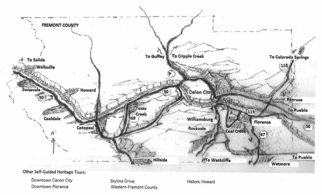
2 WESTERN FREMONT County Self-Guided Heritage Tour History from Parkdale to Wellsville as seen from US-50 About this Booklet This Self-Guided Heritage Tour was developed as part of a series by the Fremont County Heritage Commission and Fremont County Tourism Council, with support of a grant from the Colorado Tourism Office, for free distribution to convey the County s rich history and encourage heritage tourism. The Fremont County Historical Society, a 501(c)3 non-profit educational organization, is also a partner in this effort. Questions, comments and suggestions are welcome and may be conveyed to info@fremontheritage.com or sent to Fremont County Heritage Commission, 615 Macon Ave, Cañon City, Colorado, Tours that are part of this series include: Skyline Drive in Cañon City Downtown Cañon City, Colorado Downtown Florence, Colorado These and other tours to be developed may be downloaded for free at or found in racks at Chambers of Commerce and Museums throughout Fremont County. Additional information beyond the scope of this booklet may be found at these locations as well as other tours and information. Acknowledgements This all volunteer booklet was researched, compiled and written by Betsy Denney. Information Sources: The Land Beyond The Gorge by Carol McNew; From Trappers to Tourists by Rosemae Wells Campbell; Western Fremont Historical Society Archives; Interviews by Nancy Oswald and Thomas A. Young. Edited by Jim Nelson. Photos courtesy of Royal Gorge Regional Museum & History Center. Illustrations, Mildred Wintz. Layout, Larry Hill. First Published May, 2015 Historic Focus: The 50-mile stretch of US-50 from Cañon City west through Fremont County follows the Arkansas River from Parkdale to Wellsville, at the western edge of the County approaching Salida. While there are magnificent views, incredible geology, Gold Medal Trout fishing, world class rafting and rarely seen wildlife viewing opportunities along the drive; this guide will make every effort to keep its focus on late 1800s to early 1900s history as seen from the road. Drive Carefully: In addition to being an interesting drive, this 3,000 mile long coast-to-coast highway is one of only four major east-west corridors across Colorado and it is used by travelers pursuing a destination, drivers in a hurry, truckers and others who may care more about getting where they are going than what they are seeing along the road. Accordingly, please drive safely and pull off the road when possible to enjoy the views. Wildlife and Mountain Vistas: Rocky Mountain Bighorn Sheep live in the steep canyons along the Arkansas River and Bald Eagles fly above the river looking for Trout. Deer may be seen, especially along CO-69. The dramatic, and often snow covered, mountain peaks you see to south (left heading west) are in the Sangre de Cristo range that form the boundary between Fremont and Saguache Counties. Restrooms and Picnic Tables: As you travel along this stretch of US-50 you will notice facilities operated by the Arkansas Headwaters Recreation Area, a Colorado State Park managed in cooperation with BLM and the Forest Service. The park stretches from Leadville to Florence and provides river access, interpretive signs, Watchable Wildlife displays, restrooms, picnic areas and campgrounds at several sites along the road. 1 Fremont County Heritage Commission Self Guided Tours


3 Roadway History: In the 1860s, the route from Cañon City to mining camps along the upper Arkansas River followed Indian trails. At the time, Cañon City was as far as wagon loads of freight traveling to the mining camps could reach. Then hardy, adventuresome, entrepreneurial individuals such as Joseph Lamb would pack burros in order to complete the journey. The Fremont County Commissioners agreed to improve the trail in 1872 and by 1874 stagecoaches and freight wagons traveled the road between Cañon City and the growing mining towns on the upper Arkansas. The new wagon road followed a circuitous route from Cañon City crossing the river at Parkdale, traveling up what is now Copper Gulch Road, along Road Gulch, CO- 69, County Road 1A, cross country through the hills and into Pleasant Valley at Coaldale. Bicycles and automobiles began to supplant the horse and buggy, freight wagon and stagecoach as means of travel during the early 1900s and a new, more direct route was needed. The growing Good Roads movement came to Colorado in 1905 and by 1911 there was political support to improve key roads. July, 1913 saw construction start on a shorter route up the river going through what was then called the Grand Canyon of the Arkansas (officially renamed Bighorn Sheep Canyon in 1990). By September, 1915 the 21-mile cut-off was complete, taking 11 miles off the Copper Gulch route. Even though some of the work was performed by prison labor, the project cost Fremont County $50,000 and the state $100,000. Originally designated the Rainbow Route, the road was renamed by the Colorado Highway Department as U.S. Highway 50 in 1927, after the Federal Government requested all interstate roads be identified as numbered U.S. highways. WF-01: Parkdale: MM 267. Since the early 1870s, this has been a place to ford the river for freight heading to the Gold and Silver fields in Leadville and Silver Cliff. Later there was a WPA camp established on the flats about ½ mile west of the current bridge crossing the Arkansas River. (MM = Mile Marker) WF-02: DeRemer Forts: MM A series of stone forts built by Denver & Rio Grande Railroad to hold off the Santa Fe Railroad in the battle of forts and courts to build a railroad west along the Arkansas River. The Santa Fe Army was led by Bat Masterson of Dodge City, Kansas, assisted by J.H. Doc Holliday and their hired guns. D&RG Assistant Engineer James R. DeRemer had his men roll boulders over the edge of the gorge onto Santa Fe work crews and armed his men with rifles and shotguns (but no bullets) to prevent the Santa Fe crews from passing the end of their disputed right of way. There were no killings in the Royal Gorge War. Some of the stone forts are still visible north of the river at a pullout near MM WF-03: Old Road: As you travel west look above the highway to see the remains of the old road with rock retaining wall supports. These were built by prison labor. WF-04: Prison Road Camp: MM Prison labor was used to build the route west up the Arkansas River. The foundations of several buildings used to house and support the prisoners are located just east of the present day Five Points Recreational Campground on the south side of the highway. WF-05: Five Points: MM 260. Turn-in to the Right. North of the highway are the remains of a bridge used to cross the river to deposit ore samples at the railroad. Part of the bridge is now an observation deck at the east end of the AHRA Park. On the south side 2 Fremont County Heritage Commission Self Guided Tours


4 in the open areas now used as a campground was the home and office of The Assayer. Mine samples from the area were brought here for evaluation. WF-06: Pinnacle: Named after the rock outcropping near the road, local lore is that this is not an original fort used during the Royal Gorge War. Once reportedly called Old Woman Rock or Witch Rock, do you see a woman s head wearing a bonnet? WF-09: Street McCoy s Bordello: The building you see just across the river on the east side of County Road 27 was once used by Street McCoy, one of the notorious McCoy outlaw bunch, and several ladies that lived and worked at Texas Creek. The area was frequented by local cowboys as well as drifters of questionable character. WF-07: Echo: MM 257. As the highway makes a turn opening into a small park, Devil s Hole lies to the north. A large, flat area surrounded by ridges, ranchers brought cattle to the river here from the north to drink. There are remains of a line shack and corrals visible from the highway. Just west of these structures in a dry gulch is the foundation of a boarding house that was used to house miners who were mining granite for the railroad to use as riprap in erosion control along railroad beds. Granite was mined here and loaded onto trains that were sent west. WF-08: Texas Creek: MM (Pull off to the right). Established in 1875 and named by Joseph Lamb and a companion moving Texas Longhorn cattle north to Leadville. A night visitor (mountain lion or bear) spooked the cattle here, scattering them and taking two days to round up. The railroad s arrival in 1880 ensured the success of this community. Texas Creek was one of the only post offices in the area. Letters have been found with a Texas Creek address dated Cattle, other agriculture products, minerals and charcoal were shipped from the Texas Creek siding, an integral part of the community. WF-10: Texas Creek: On the south side of US-50, east of Highway 69 are the remains of the railroad spur that traveled south up Texas Creek to Westcliffe. The railroad bed is visible in several locations on the east side of the highway. As in other areas, the Denver & Rio Grande Railroad did what they could to hold costs down, so instead of building the railroad to the mines of Silver Cliff, Rosita and Querida they formed the new town of Westcliffe, one mile west of Silver Cliff and lower in elevation. This spur was built after the original spur up Grape Creek from Cañon City flooded two years in a row. WF-11: Texas Creek Charcoal Kilns: The remains of the charcoal kilns lie between the railroad and the river ½ mile west of Texas Creek along the track. There were seven kilns used to make charcoal to be shipped to the CF&I steel mills in Pueblo. Charcoal was made from the pinion trees along the hills of the area. The making of charcoal was a major industry in the area having kilns at Texas Creek, Cotopaxi, Coaldale, Howard and Wellsville. WF-12: Fernleaf Gulch & McCoy Corrals: MM Cattle grazed these hills along the river and became a source of a starting herd as well as easy money through rustling from larger ranchers in the area. This area of Fremont County was difficult to access and was known as an area where outlaws could travel fair 3 Fremont County Heritage Commission Self Guided Tours


5 ly easily. The Dalton Gang was rumored to visit the area and the group that hung around the McCoy ranch were known to some as the Wet Mountain Gang. North of US-50 is the site where the body of a detective investigating rustling activities was left at the corrals. Noted range detective and Pinkerton agent Tom Horn was called in when a D&RG train was robbed in August, 1891 to get money needed for the defense of Old Dick McCoy and a son on trial for the murder of the range detective. This lead to a man hunt through southern Colorado and into Utah resulting in the capture and conviction in January, 1892 of the robbers several of the McCoys and some of their associates. WF-13: Cotopaxi: MM (Turn right or north). Established in 1870 and named after a volcano in Ecuador. Much of the community is north of the river. Cotopaxi was a community that was settled with some residents of questionable character due to the fact that it was more isolated. Two early settlers to the area were Gold Tom (Henry Thomas) and Emmanuel Saltiel. Thomas was the first owner of the Cotopaxi Mine and the person naming Cotopaxi. Saltiel was a Jewish prospector and entrepreneur that brought in 70 Jewish Colonists escaping Tsarist Russia in It was estimated in the 1890s that more than 500 residents made their home in Cotopaxi. There were at least two boarding houses, two stores and two saloons in town. Gold Tom was killed in a June 1884 old west shoot-out at one of the boarding houses. WF-14: Plum Street, Cotopaxi: Cotopaxi has one street, Plum Street, named because it runs plum through town. Some of present homes were said to have been built by the Russian Jewish immigrants in They were home to miners, railroad workers and cowboys and today are rarely vacant. The D&RG Western Railroad, built as narrow gage in 1881 and expanded to standard gage in 1890, had workers here along with a passenger depot, freight station and siding. As many as 20 trains per day rumbled through as recently as 1996, prior to the Tennessee Pass route being mothballed by Union Pacific in WF-15: Cotopaxi School: There was a school here as early as The location of the original building is thought to be close to the current school, which was constructed after an earlier building burned to the ground in March The original gymnasium (completed in 1938) and the foundation were all that was saved. The cafeteria was built on the old foundation and the school was added onto the gym. Students were only out of school about three weeks until another school building from Nesterville (north of Cotopaxi) could be brought down. Today, there have been several additions and remodels, but the 1939 building is still being used. Students as far as Copper Gulch to the east and Howard to the west attend school here. The school is proud of their accomplishments as a School of Distinction from the State of Colorado. 4 Fremont County Heritage Commission Self Guided Tours WF-16: Cotopaxi Cemetery: Established in 1882 and located ¼ mile off County Road 12 west of Cotopaxi School. The first to be buried were four Russian Jewish children who died from typhoid or pneumonia. The land was donated by Emmanuel Saltiel. The cemetery still serves the community and former residents. Other infamous characters have also taken up permanent residence in the cemetery, among them members of Quantrill s Raiders.


6 WF-17: San Isabel View Cemetery (Hillside): (Side trip off US-50 on County Road via 1A and CO-69) MM 74. Established in 1874 and located off County Road 32 approximately 2 miles east of CO-69. The cemetery is on the south side of the road facing west overlooking the Wet Mountain Valley and the Sangre de Cristo Mountain Range. The cemetery still serves the current and former area residents. WF-20: Coaldale Community Building: Built in 1923 and located on Hayden Creek Road, CR-6 at the intersection with CR-45, this was the last school building in Coaldale before the school consolidated with Cotopaxi in The Coaldale Grange also used this building as a meeting place. Today the building is the center of the community; home to morning coffee, farmers market and community meetings. WF-18: Hillside Grange Building: MM Built in along the Fremont/Custer county line, approximately 10 miles south of US-50 on CO-69, is the town of Hillside. On the north side of town and in Fremont County is the Hillside Grange Building. The land and building was donated as a meeting place for the Grange, a farmer s organization formed to meet the social, political, and economic interests of its members. Grange meetings were held here until In addition to the Grange meetings other community activities occurred here such as dances, weddings, funerals, potluck dinners and fund raisers. The park around the building is home to the oldest and largest Black Willow Grove in the western United States. This grove has served the area for over 150 years. (Return to US-50 via CO-69 or take County Road 1A at MM 74.8 to Cotopaxi; continue west on US-50) WF-19: Coaldale: MM (Turn left (south) on the Hayden Creek Road, CR-6). Established in 1871 with the Hayden family the first to settle here. Other early settlers were the Muehlbach, Poulson and Gilray families. Descendants still reside in the area. The community had several names before settling on Coaldale, including Palmer, Hendricks and the railroad s name of Pleasanton. Agriculture and mining were important to the settlement of the Pleasant Valley of which Coaldale is a part. These two industries are still evident today. Coaldale once boasted the third largest school district in the county with seventy-two students, a post office, hotel and store. 5 Fremont County Heritage Commission Self Guided Tours WF-21: Coaldale Charcoal Kilns: Of all the kilns along the Upper Arkansas route, these are located furthest from the railroad. There were at least five and, while on private property, they can be observed driving south on County Road 6. The kilns were in operation from the late 1880s into the 1900s. The Coaldale Charcoal Kilns are Fremont County Heritage Sites dedicated in Charles Bushnell (on the left in the photo) prospected in the Sangre De Cristo mountains above Coaldale in the early 1900s. He discovered several ledges of colored marble at timber line and both Bushnell Peak (the highest point in Fremont County) and Bushnell Lake are named after him. WF-22: Coaldale Cemetery: Established in 1879, located ¾ mile up County Road 6. The first burial was Joseph Toupain, six years old. Joseph s father owned the store in Coaldale with O.B. Carroll. County Road 6 was the main road traveling over Hayden Pass and into the San Luis Valley near present day Villa Grove. This road was completed by Toupain and Carroll. The cemetery still serves the community and former residents. WF-23: Barnes City: Three miles south on County Road 6, near Cutty s Camping Resort is the site of Barnes City. The area was first promoted as a mining area in the early 1900s but became more of a resort boasting a dance hall,


7 fine dining and liquor as well as horse racing and gambling. More money was made with the resort than by mining. At one time there were over three hundred buildings in the area. This same area was the site of a tuberculosis camp for TB victims seeking a dryer climate; many are buried at the local cemetery. (Turn around and return down CR-6 and turn left at CR-45 or return to US-50) WF-24: County Road 45: This road is part of the old stagecoach road that connected east and west Fremont County. The stage road crossed the river at Parkdale, traveled up what is now Copper Gulch Road, Road Gulch, Highway 69, County Road 1A, cross country through the hills and into the east end of Coaldale to CR- 45. This road crosses Highway 50 and then the river at Vallie. The stage road (CR-45) travels on the north side of the river to Wellsville where it again crosses the river and travels on to Salida. Although this section of the road is open to the public, the area west of Howard requires 4-wheel drive. WF-25: Vallie: MM on US-50. This was a railroad siding with a depot, boarding house, and several buildings for workers. The only thing remaining is a small apple orchard. Several orchards like this are scattered throughout the area, a reminder of old homesteads. The homesteaders often planted orchards when first settling, sometimes before building their permanent homes. WF-26: Pathways to History: Notice the Pathways to History interpretive signs. This is a separate tour with many interpretive signs on pullouts accessible from CR-45. WF-27: Howard Cemetery: Established in 1874 and located at MM 8-9 on CR-45. The first burial was E. Foster Stout, five year old son of William and Elvira Stout, one of the first families to settle in the area. The cemetery continues to provide the community with a picturesque view of the Sangre de Cristo range and the Pleasant Valley. 6 Fremont County Heritage Commission Self Guided Tours WF-28: Old Howard School: The first school building in the area is located at MM 6-7 on CR-45. This was the original Howard School until a 1908 move to a larger building on CR-4. WF-29: Howard: Established in The area had fertile soil and good range for cattle. Some of the original settlers to the area were Jonah Peregrine, William Stout and family, and eventually John Howard, after whom the community is named. Howard was the railroad center of the area shipping ore from neighboring Calcite, charcoal, and cattle. Howard is built in a square that had a post office, hotel, church and parsonage. CR-4 loops around historic Howard and a selfguided tour of the original buildings is available. (Turn left at Howard Hall and follow CR-4 across the river back to US-50. To continue the Howard area tour, cross US-50 and continue on CR-4). WF-30: Howard School: Located on County Road 4 (Howard Creek Road) ½ mile south of US-50 on the hill. This property was donated by Louis Freeman and was built of brick in 1908 for those in the western part of the valley. There were two rooms, one room for grades 1-4 and the other for grades 5-8. The building is now a private residence. WF-31: Calcite: Located on County Road 4 about 3-miles from US-50. This was a town started by Colorado Fuel & Iron Company in 1902 for the sole purpose of mining the limestone and dolomite for the CF&I mill in Pueblo. Calcite continued to operate until 1929 when a slump in economy caused the shutdown. During this time period the town, consisting of three camps, had a railroad spur, post office, company store, club house, school and houses for the miners. The miners were of mixed nationalities emigrating from Europe, mostly Italy. At the peak it was estimated to have between 500 and 1,000 people in Calcite, which existed for 23 years. Some of the houses were later moved to Howard and Salida. D&RG took out the tracks in 1936, but the old railroad bed can still be seen. Today the area is private residences. (Return to US-50 and turn right on to continue Howard area tour)


 WF-33: Stout Stone House: MM 236 (pullout to the right). Located south of US-50 is the Stout House.")
8 WF-32: Stout School: MM (Turn right on Cherry Creek Road, the school is on the left just up the road). The Stout School, on Cherry Creek Road, was built in 1908 on the land donated by William Stout. The Stout Creek School District was organized in 1873 but the first school building was located east on Hamilton Creek. The older Stout girls boarded in the area to attend school, which was only three months long. This school on Stout Creek had grades 1-8 in the one room building. High school students were sent to Salida, where they boarded during school sessions. (Turn around at the school to return to US-50, turn right to continue the Howard area tour) WF-33: Stout Stone House: MM 236 (pullout to the right). Located south of US-50 is the Stout House. William and Elvira Stout were among the original settlers of the area. Their family moved from Tennessee in 1869 and arrived in the Pleasant Valley in The land was fertile and water along the creeks kept their herd of cattle. This house was completed in 1885 and was the Stout s second house here. It was built from native stone quarried along the banks of the Arkansas River on the Stout s homestead. Jonah Peregrine, another settler in the area, helped build the house. Several landmarks were named by or after Stout. William named the Twin Sisters (two mountain peaks viewed from the valley) and Stout Creek. Stout Street in Denver is named for a cousin (Richard) who also traveled west with William. first white child (Cora) born in Western Fremont County was born to Mr. & Mrs. Stout in January 1875 in this cabin. (Return to US-50 and turn right) WF-35: Kerr Gulch Quarry: MM (Turn right on Kerr Gulch road and go about ½ mile on the dirt road). One of several quarries in the area, started in Stone was cut and hauled across the river to be loaded on railroad cars. There is still evidence of the bridge where it crossed the river. The stones were used for the Denver Mint, the Stout School on Cherry Creek, several prominent homes in Denver and many buildings in Cañon City. There is no activity here at present. (Return to US-50, this concludes the Howard area portion of this tour. Turn left on US 50 to continue toward Swissvale and Wellsville). WF-36: Swissvale: MM 229. Established in 1881 by Max Zeise, a Swiss dairy man who supplied dairy products for the valley. There was a huge railroad tie hack yard here. Swissvale was almost a ghost town until 1960 when a café and gas station started (now closed). Today the area is mainly residential. WF-37: Wellsville: MM 227. Established in 1881 by George Wells as a pleasure resort with guests coming to enjoy the mineral hot springs. Lime was evident in the water of the springs. Old masses of tufa built up around the springs and were mined. Wellsville had a post office, a hotel, a dance hall and a baseball diamond. Travertine marble was quarried here. Today a soil amendment plant and an aerial adventure park operate on CR-7. WF-34: Stout Log Cabin: MM 236 (Just ¼ mile east turn right on Zabrisky Lane and follow the street around to the right to the cabin, located on private property but visible from the road and marked). This log cabin was built in 1872 shortly after the Stouts settled in the area. The 7 Fremont County Heritage Commission Self Guided Tours
Stagecoach Ranch. Colorado - Fremont County - Texas Creek 1
 Stagecoach Ranch Selected for the classic western film Cat Ballou, the Stagecoach Ranch features lush meadows, rock outcroppings, foothills, and 1 1/2 miles of Texas Creek in a picturesue setting with
YOU ARE INVITED TO THE PROGRAM ON SUNDAY - MAY 21, 2017 FREMONT COUNTY HISTORICAL SOCIETY NEWSLETTER
 FREMONT COUNTY HISTORICAL SOCIETY NEWSLETTER MAY 21, 2017 VOLUME 15, ISSUE 3 WEBSITE: fremontheritage.com WE ARE ON FACEBOOK, TOO: Fremont County Historical Society - Colorado YOU ARE INVITED TO THE PROGRAM
Driving Time: 3 hours (allow extra time for stops)
") Scenic Byways loop This journey takes visitors through the eastern edge of Mt. Rainier National Park and along two of Washington s most beloved scenic byways, the Chinook Byway and the White Pass Scenic
Scenic Byways loop This journey takes visitors through the eastern edge of Mt. Rainier National Park and along two of Washington s most beloved scenic byways, the Chinook Byway and the White Pass Scenic
Hartsel Springs Ranch 4,637 Acres Park County, Colorado $4,780,000
 Hartsel Springs Ranch 4,637 Acres Park County, Colorado $4,780,000 Presented By: Farm, Ranch & Recreational Real Estate Hartsel Springs Ranch 4,637 Acres Park County, Colorado $4,780,000 Property Description
FREMONT COUNTY HISTORICAL SOCIETY NEWSLETTER
 MARCH 2017 FREMONT COUNTY HISTORICAL SOCIETY NEWSLETTER VOLUME 15, ISSUE 2 `WEBSITE: fremontheritage.com WE ARE ON FACEBOOK, TOO: Fremont County Historical Society - Colorado Editor: Carol McNew, Readers
BACKROADS BICYCLE/AUTOMOBILE TOUR OF MIDDLESEX, VERMONT
 BACKROADS BICYCLE/AUTOMOBILE TOUR OF MIDDLESEX, VERMONT (created and published by the Middlesex Historical Society) Welcome to a 25-mile self-guided historical tour of the backroads of Middlesex. You may
 Augusta 287 200 287 Ovando 200 Lincoln Wolf Creek Craig Garnet 90 GARNET RANGE Drummond 141 Marysville 15 BIG BELT TAINS Granite Philipsburg 1 NGE CREEK Deer Lodge Elliston 12 Helena Rimini Comet 15 287
PAUL S PLACE ELK, DEER AND VIEWS FISHTAIL, MONTANA
 McCaslin Land 2010 PAUL S PLACE ELK, DEER AND VIEWS FISHTAIL, MONTANA LOCATION Paul s Place is ideally located in the foothills of the Beartooth Mountains, approximately 5 to 5-1/2 miles west of Fishtail,
Skyline Drive Hogback Canon City
 Skyline Drive Hogback Canon City Direction to trailhead: From US 50, turn north onto 15th Street. At the traffic circle, continue north on 15th Street until it dead ends at Washington Street (about 1.5
TAYLOR CANYON RANCH COLORADO - ROUTT COUNTY - STEAMBOAT SPRINGS
 TAYLOR CANYON RANCH COLORADO - ROUTT COUNTY - STEAMBOAT SPRINGS Tucked up against the steep valley shaped by Mt. Pau and rising to the Routt National Forest, Taylor Canyon Ranch is an easily accessible,
Brinker Creek Ranch. Colorado - Routt County - Yampa
 Located at the base of the Flattops Range in the Steamboat/Vail corridor, Brinker Creek Ranch consists of 1,451 acres ideally suited for high country grazing and native grass hay production. Traditionally
MP : Blue Hill and the Disney Avalanche Path
 MP 252-253: Blue Hill and the Disney Avalanche Path This section of the Auto Tour includes a portion of the wagon road, one of Colorado s most famous avalanches and the remains of an old dam. Route Mile
Corridor Management Plan for Virginia Coal Heritage Trail WMTH Corporation, 2011, trailsrus.com
 CHAPTER IV: HIGHLIGHTS Along the The St. Paul loop travels over 80 miles through the counties of Russell, Scott, Lee and Wise before ending back at St. Paul. As noted earlier, St. Paul holds the distinction
B HALL RANCH FISHTAIL, MONTANA
 Brochure Courtesy of: B HALL RANCH FISHTAIL, MONTANA w w w. m c c a s l i n l a n d. c o m Page 1 LOCATION The Hall Ranch is ideally located in the foothills of the Beartooth Mountains, approximately 5
SAN MIGUEL CREEK RANCH. q Trinidad, Las Animas County, Colorado q
 SAN MIGUEL CREEK RANCH q Trinidad, Las Animas County, Colorado q 2 s San Miguel Creek Ranch is a scenic well-balanced cattle and trophy hunting ranch that showcases the very best of Southern Colorado.
Morrill Act. frontier. transcontinental railroad. boomtowns reservations. sodbusters. Homestead Act deflation. cattle drive
 Vocabulary 17: End of the Frontier Cut out each picture and paste into the notebook on the left side of the page. Next to each picture, define the term in seven words or less. Words followed by an asterisk
MP : The Big Chief Overlook and the Glen
 MP 253 254: The Big Chief Overlook and the Glen The mile between MP 253 and 254 has lots of history in it. It includes the only recorded remains of the Victory Highway on the Clear Creek County side of
Mills Pecos River Ranch 7800 Acres Val Verde County, Texas Situated along both sides of the Pecos River
 Mills Pecos River Ranch 7800 Acres Val Verde County, Texas Situated along both sides of the Pecos River James King, Agent Office 432-426-2024 Cell 432-386-2821 James@KingLandWater.com King Land & Water
The gorges of Mohican Park in Ohio create a hiker's paradise Sunday, May 22, 2011 By Bob Downing, Akron Beacon Journal
 Pittsburgh Post-Gazette The gorges of Mohican Park in Ohio create a hiker's paradise Sunday, May 22, 2011 By Bob Downing, Akron Beacon Journal Bob Downing Big Lyons Falls drops 80 feet into a shady U-shaped
2012 Colorado Planning & Management Region Report
 INTRODUCTION 2012 Colorado Planning & Management Region Report The San Luis Valley in south central Colorado is the largest alpine valley in North America, bordered on the east by the Sangre de Cristo
BUTCHER CREEK RANCH. Butcher Creek Ranch. Roscoe, Montana. Reduced to $1,650,000.
 BUTCHER CREEK RANCH Butcher Creek Ranch Roscoe, Montana Reduced to $1,650,000. Offered Exclusively By: Sonny Todd Real Estate 301 West First Avenue, PO Box 788 Big Timber, Montana 59011 Office: (406) 932-1031
2015 USA Pro Challenge (Stages 3 and 4) State Highway 82 Spectator Guide to Parking and Camping on Independence Pass
 State Highway 82 Spectator Guide to Parking and Camping on Independence Pass") 2015 USA Pro Challenge (Stages 3 and 4) State Highway 82 Spectator Guide to Parking and Camping on Independence Pass Stage 3 Copper Mountain Resort to Aspen, Wednesday, August 19 Racers will head south
2015 USA Pro Challenge (Stages 3 and 4) State Highway 82 Spectator Guide to Parking and Camping on Independence Pass Stage 3 Copper Mountain Resort to Aspen, Wednesday, August 19 Racers will head south
AOTA ArtTrek Locations
 AOTA ArtTrek Locations ArtTrek is a summer-long Grand County, CO art adventure. Highlighted by snow-covered mountain vistas and rolling meadows threaded with sparkling streams and rivers, numerous sites
Beaver Country Trails ATV Jamboree
 Beaver Country Trails ATV Jamboree #1 Lincoln Mine Intermediate (Open to all ATVs/UTVs) 34 Miles Highlights: This ride will highlight the historic Lincoln Mining District, the first lead mine in Utah,
MP : The Empire Toll Gate and Glen Arbor
 MP 255 256: The Empire Toll Gate and Glen Arbor This section includes the location of the Empire Toll Gate, Glen Arbor and a reservoir. Route Mile Marker X Y Longitude Latitude 1 U. S. Highway 40 255 439593.25
C E N T R A L C A T S K I L L S
 120 C E N T R A L C A T S K I L L S Central Catskills Once out of the southern parts of the Catskills, the Long Path enters the more well traveled and civilized regions. The trail joins the Devil s Path,
Trail Beginning Elevation: 7553 ft The Poison Creek Trailhead is located at the end of National Forest Road 646E (NF-646E).
.") West Mountain Trails Poison Creek Trail #134 Length: 2.9 miles (4.7 km) Difficulty Horseback: A good trail for the first time west mountain rider, some steep sections Hiking: Most Difficult USGS Maps:
West Mountain Trails Poison Creek Trail #134 Length: 2.9 miles (4.7 km) Difficulty Horseback: A good trail for the first time west mountain rider, some steep sections Hiking: Most Difficult USGS Maps:
BROCHURE. APPLE HILL WOODS 118 +/- Acres Camino, California. Presented by Jim Copeland
 BROCHURE APPLE HILL WOODS 118 +/- Acres Camino, California Presented by Jim Copeland 1 The Property This 118 acre is a rare gem in the Sierra Nevada foothills. Covered with lush forestland and scattered
TOWNSHIP OF HILLSIDE, NJ.
 TOWNSHIP OF HILLSIDE, NJ. HILLSIDE Formed as Township: 1913 1970 Population: 21,636 Land Area 2.70 square miles The initial settlement of the township now known as present day Hillside followed shortly
Ponderosa Pines Ranch
 PONDEROSA PINES RANCH Ponderosa Pines Ranch Shepherd, Montana $3,285,000. Offered Exclusively By: Sonny Todd Real Estate 301 W First, PO Box 788 Big Timber, MT 59011 Office: (406) 932-6668 (406) 932-LAND
NATIONAL ATV / UTV JAMBOREE RIDES
 NATIONAL ATV / UTV JAMBOREE RIDES Note: Rides range from Beginner to Advanced and will last from 2 to 3 hours or an entire day of riding. 1. DESERT RIDE (CLEAR LAKE BIRD REFUGE & LACE CURTAINS/LAVA TUBES)
CK Ranch Sublette County, Wyoming
 CK Ranch Sublette County, Wyoming 1 Since originally homesteaded in the late me of the finest recreational hunting and e ribbon trout fishing, bordering 5 miles of on request. 2 The CK Ranch is located
Below is the section of the Byway discussed in the Wise/Russell County meeting. Primary coal sites are noted on the map.
 APPENDIX H: PUBLIC PARTICIPATION SERIES OF TOWN MEETINGS Virginia Coal Heritage Trail Corridor Management Plan Meeting in St. Paul on the Wise and Russell County portions of the St. Paul Loop September
BUCK POINT RANCH. Aspen Associates Realty
 BUCK POINT RANCH Aspen Associates Realty www.aspenassociatesrealty.com 970.544.5800 WELCOME TO Buck Point Ranch is a 960± acre property located in one of the last pristine valleys in close proximity to
Crystal Lake Area Trails
 Lake Area Trails Welcome to the Lake area of the Big Snowy Mountains! This island mountain range in central Montana features peaks reaching to 8,600 feet and long, high ridges from which vistas of the
The Holzworth Family. Papa, Marie, Julia, John, Sophie and Mama. Johnnie Holzwarth and Caroline (Pratt) Virginia, Mary Francis and John III
 Virginia, Mary Francis and John III") The Holzworth Family John Gotlieb Holzworth Sophie Lefromm Holzworth Papa, Marie, Julia, John, Sophie and Mama Johnnie Holzwarth and Caroline (Pratt) Virginia, Mary Francis and John III HOLZWORTH TROUT
The Holzworth Family John Gotlieb Holzworth Sophie Lefromm Holzworth Papa, Marie, Julia, John, Sophie and Mama Johnnie Holzwarth and Caroline (Pratt) Virginia, Mary Francis and John III HOLZWORTH TROUT
MEEK tart'
 MEEK tart' Post Card Nebraska is one of the nation's leading stock raising areas. It is famous for dairy products. Corn, grain, hay and sugar beets grow in abundance. Industrial activity has rapidly developed.
City of West Wendover
 City of West Wendover by Allan Anderson The community of Wendover came into existence in 1906 as a railroad town, serving the steam engines of the Western Pacific Rail, which is now part of the Union Pacific
Kit Carson-Challenger Ridge Trail Project Annual Performance Report-2014 October 22, 2014
 1 Kit Carson-Challenger Ridge Trail Project Annual Performance Report-2014 October 22, 2014 Willow Lake and Kit Carson Peak 2 SUMMARY The Rocky Mountain Field Institute began Phase 1 of a multi-phase,
United States Forest Service Outreach Notice Pike and San Isabel National Forests-Cimarron and Comanche National Grasslands
 United States Forest Service Outreach Notice Pike and San Isabel National Forests-Cimarron and Comanche National Grasslands Outreach Notice valid through April 3, 2013 Rangeland Management Specialist GS-0454-9/11
G R E E N R I V E R - W Y O M I N G - S W E E T W A T E R C O U N T Y
 G R E E N R I V E R - W Y O M I N G - S W E E T W A T E R C O U N T Y Minor Ranch All information contained herein is taken from sources considered reliable, but is not guaranteed by either seller nor
The following criteria were used to identify Benchmark Areas:
 7.0 BENCHMARK AREAS The Churn Creek Protected Area offers a significant opportunity to learn more about how grassland ecosystems function. One of the key tools that will be used to monitor larger grassland
National Parks Called America s Best Idea
 National Parks Called America s Best Idea Welcome to This Is America in VOA Learning English. I'm Jim Tedder. And I'm Kelly Jean Kelly. This week on our program, we talk about national parks in the United
American Safari Ranch Summary
 SIZE: 404+/- deeded acres, 640 acre State Lease for grazing and recreation, 640 in Sec 24 and portions of Sections 13 and 23 BLM acres leased for horseback riding. LOCATION: LEGAL: HISTORY: ACTIVITIES:
GIFFORD PINCHOT NATIONAL FOREST
 GIFFORD PINCHOT NATIONAL FOREST 9341 Wright Meadow 93 Spencer Meadow Spencer Butte 4247' 30 30A 19 24 80 31C Lewis River Lower Falls 5 Quartz Creek 90 Taidnapam Falls Upper Falls 31 Spencer Peak 3861'
NATIONAL ATV / UTV JAMBOREE RIDES
 NATIONAL ATV / UTV JAMBOREE RIDES Note: Rides range from Beginner to Advanced and will last from 2 to 3 hours or an entire day of riding. 1. DESERT RIDE (CLEAR LAKE BIRD REFUGE & LACE CURTAINS/LAVA TUBES)
January 18, 1997 Oatman site to Sears Point and Maxwell Point, Arizona Southern Trail
 January 18, 1997 Oatman site to Sears Point and Maxwell Point, Arizona Southern Trail 1997 This was a day trip led by Boma Johnson. He worked for the BLM out of Yuma and was a trail contact person for
Flying W Guest Ranch. Oklahoma - Beckham County - Elk City
 Flying W Guest Ranch Oklahoma - Beckham County - Elk City 2 Flying W Guest Ranch is a well-known guest ranch in a historic location about 90 miles west of Oklahoma City near Elk City, Oklahoma. Situated
Rogue Gorge (Mt. Stella) Roadless Area-- T30S R3E (primarily in portions of Sections 23, 26, 33, 34 & 35)
 Roadless Area-- T30S R3E (primarily in portions of Sections 23, 26, 33, 34 & 35)") Rogue Gorge (Mt. Stella) Roadless Area-- T30S R3E (primarily in portions of Sections 23, 26, 33, 34 & 35) Rogue River-Siskiyou National Forest--High Cascades Ranger District Upper, higher elevation trail
Rogue Gorge (Mt. Stella) Roadless Area-- T30S R3E (primarily in portions of Sections 23, 26, 33, 34 & 35) Rogue River-Siskiyou National Forest--High Cascades Ranger District Upper, higher elevation trail
COPPERFIELD HOMESTEAD 240 Acres Fremont County, CO $820,000
 F a r m, Ranch & Recreation a l Real Esta t e COPPERFIELD HOMESTEAD 240 Acres Fremont County, CO $820,000 http://www.haydenoutdoors.com/land-for-sale/copperfield-homestead PROPERTY SUMMARY $820,000 Total
ROYAL GORGE PARK and RECREATION AREA. A Feat of Natural and Man-Made Engineering
 ROYAL GORGE PARK and RECREATION AREA A Feat of Natural and Man-Made Engineering As Growth Resumed in the 1870 s Town Leaders Began to Envision a Tourist Industry. The Arkansas River Canyon was advertised
Royal Gorge Far Out Trail to Le Point
 Royal Gorge Far Out Trail to Le Point Direction to trailhead: From East Ridge Campground: Drive west from Canon City on US 50 to County Road 3A, the entrance road to the Royal Gorge Park. Turn left onto
Northeast Quadrant Distinctive Features
 NORTHEAST QUADRANT Northeast Quadrant Distinctive Features LAND USE The Northeast Quadrant includes all the area within the planning area that is east of Interstate 5 and to the north of State Route 44.
Ranch. Creek. Cow. Mountain
 Cow Creek Mountain Ranch Situated along the southwestern hills of the Laramie Mountains and the Medicine Bow-Routt National Forest in northeastern Albany County, Wyoming. 58 E. Benteen Street Buffalo,
Letter Assessment. (date) Dear, In 1864, Then in 1866, In 1867, As it happened in 1868, Then in 1877, The bust came in.
 Dear, In 1864, Then in 1866, In 1867, As it happened in 1868, Then in 1877, The bust came in.") Letter Assessment (date) Dear, In 1864, Then in 1866, In 1867, As it happened in 1868, Then in 1877, The bust came in. Your friend, The Birth of a City and Railroad in the Rocky Mountains Modified for
Letter Assessment (date) Dear, In 1864, Then in 1866, In 1867, As it happened in 1868, Then in 1877, The bust came in. Your friend, The Birth of a City and Railroad in the Rocky Mountains Modified for
Stephens State Park Trails
 TRAILS OF ALLAMUCHY MOUNTAIN & STEPHENS STATE PARKS Allamuchy Mountain and Stephens State Parks contain 28 marked trails providing access to diverse landscapes for walking, hiking, biking, bird-watching,
26 Utah s Patchwork Parkway SCENIC BYWAY CORRIDOR MANAGEMENT PLAN (SR 143)
") Natural Natural Quality applies to those features in the visual environment that are in a relatively undisturbed state. These features predate the arrival of human populations and may include geological
Natural Natural Quality applies to those features in the visual environment that are in a relatively undisturbed state. These features predate the arrival of human populations and may include geological
The Loneliest Road in America Highway 50, Nevada (N16C)
") The Loneliest Road in America Highway 50, Nevada (N16C) U.S. Highway 50 crosses Nevada s mid-section, entering the state from Utah near Baker and Great Basin National Park, and leaving Nevada in the west
The Loneliest Road in America Highway 50, Nevada (N16C) U.S. Highway 50 crosses Nevada s mid-section, entering the state from Utah near Baker and Great Basin National Park, and leaving Nevada in the west
Colorado s forests are slated to lose thousands of miles of roads through the new OHV Route Designation process. DON T LET IT HAPPEN!
 Colorado s forests are slated to lose thousands of miles of roads through the new OHV Route Designation process. DON T LET IT HAPPEN! This packet identifies many roads that you may lose if you don t act.
April 10, Mark Stiles San Juan Public Lands Center Manager 15 Burnett Court Durango, CO Dear Mark,
 Mark Stiles San Juan Public Lands Center Manager 15 Burnett Court Durango, CO 81301 Dear Mark, We are pleased to offer the following comments on the draft San Juan Public Lands Center management plans
Cherokee And The Concow Dam
 Cherokee And The Concow Dam In 1853 Sol Potter, a school teacher from the Cherokee Nation in Oklahoma along with several students discovered gold in Butte County and named the area Cherokee. Others soon
Lane Residence. Silverthorne, Colorado. Offered for $3,999,999. Contact Bill George. (970)
") Lane Residence Silverthorne, Colorado Offered for $3,999,999 Contact Bill George (970) 485 1052 bill@ranchland.com Ownership of this 6,450 square foot custom log home at Shadow Creek Ranch gets you access
Lane Residence Silverthorne, Colorado Offered for $3,999,999 Contact Bill George (970) 485 1052 bill@ranchland.com Ownership of this 6,450 square foot custom log home at Shadow Creek Ranch gets you access
Case 1:12-cv JLK Document 36 Filed 08/06/13 USDC Colorado Page 1 of 24 UNITED STATES DISTRICT COURT DISTRICT OF COLORADO
 Case 1:12-cv-00265-JLK Document 36 Filed 08/06/13 USDC Colorado Page 1 of 24 Civil Action No. 12-cv-00265-JLK UNITED STATES DISTRICT COURT DISTRICT OF COLORADO RAGS OVER THE ARKANSAS RIVER, INC., Petitioner,
Central Overland Trail Utah & Nevada Driving Guide, First Edition, 2016
 Central Overland Trail Utah & Nevada Driving Guide, First Edition, 2016 Page 51 In the third paragraph, second sentence, change 0.4 miles to 0.1 miles. In the fourth paragraph, second sentence, change
Montana The True Rockies Experience
 Montana The True Rockies Experience 2011/12 MOMENTUM A D V E N T U R E Welcome to your exclusive Ranch experience... We offer levels of personal service often aspired to, but rarely achieved. A totally
St. George Jeepers Torrey, Utah, Fall Foliage Outing September 26, 2016
 St. George Jeepers Torrey, Utah, Fall Foliage Outing September 26, 2016 On a beautiful, sunny fall day fourteen vehicles departed the Maverick station in Cedar City for a ride to Torrey, Utah. We were
At the time, the portion of the line through Eagle County remains wholly under the ownership of Union Pacific Railroad (UP).
.") Chapter 5 The Railroad Corridor as a Trail Corridor The intent of this chapter is to identify how the rail corridor, if available for lease or purchase in all or part, could be incorporated into the core
Chapter 5 The Railroad Corridor as a Trail Corridor The intent of this chapter is to identify how the rail corridor, if available for lease or purchase in all or part, could be incorporated into the core
Daisy Dean Creek Ranch
 Daisy Dean Creek Ranch MARTINSDALE, MONTANA Hunting Ranching Fly Fishing Conservation Daisy Dean Creek Ranch MARTINSDALE, MONTANA Introduction: Daisy Dean Creek Ranch is comprised of 1,652 acres with a
Saratoga, Wyoming RIVERBEND LODGE. page 1
 Saratoga, Wyoming RIVERBEND LODGE page 1 A BRIEF HISTORY OF THE AREA Wyoming s rich history is laced with tales of transportation and trails as first the Native Americans, then the fur traders, mountain
4th Grade Third 9 Weeks Test
 4th Grade Third 9 Weeks Test Multiple Choice Identify the choice that best completes the statement or answers the question. 1 A waterway for ships that is dug across land is called a. A port C river B
THE GHOST ROSE RANCH. Randy J. Wood Qualifying Broker Cell:
 Wild West Properties, LLC 7020 Santa Marisa, NE Albuquerque, NM 87113 505-836-4558 http://www.wildwestproperties.com/ Randy J. Wood Qualifying Broker Cell: 505-980-8019 E-mail: rjwood5@comcast.net THE
Wright City Business Park
 Wright City Business Park 51.69 Acres SITE Wright City Business Park is a 51.69 acre site ideal for large distribution or manufacturing uses. Located approximately ¼ mile west of I-70 exit 199, Wright
Kitimat. Pacific Inland Coast. Hiking Guide Kitimat, British Columbia, Canada
 Kitimat Pacific Inland Coast Hiking Guide Kitimat, British Columbia, Canada 2010-2011 Sites and Trails Emergency Call 911 Police - Fire - Medical 2 Welcome to Kitimat This information was produced to assist
Difficult Run Stream Valley Park
 Difficult Run Stream Valley Park The more intense mountain bikers have known about for Difficult Run for some time. Equestrians have known it longer. Eight miles of unpaved trail, the Rails to River Trail
Unit 11: Travel and Trade
 Unit 11: Travel and Trade Today Due: Current Events Article Assignment Quiz: Unit 10 (Value of Land) In class: Unit 11 (Travel and Trade) HW: wkbk 97-102, study for quiz 11, read Unit 12 (155-166) Lesson
Below is the section of the Byway discussed in the Wise County meeting. Primary coal sites are noted on the map.
 APPENDIX H: PUBLIC PARTICIPATION SERIES OF MEETINGS Virginia Coal Heritage Trail Corridor Management Plan Meeting In Big Stone Gap on the Wise County portion of the Norton Loop September 20 th 2010 at
MP : Headwaters of the Fraser River
 MP 236 237: Headwaters of the Fraser River The mile between these two mileage posts is often just referred to as the bottom switchback or the curve at the bottom of Berthoud Pass. For many locals this
THE SETTING REGION COMMUNITY ANALYSIS
 THE SETTING REGION COMMUNITY ANALYSIS REGION Historical Setting The Crane Lake waterway pre-dates the American Indians who traveled its waters for generations before it became a fur-trading route for the
Middle Creek a streaming resource
 Middle Creek a streaming resource The Middle Creek Watershed has a long history of human activity. Native Americans used the watershed before the European settlers; they traveled, hunted, and settled in
Lava Mountain Trail Distance: Elevation Range: Trail Type: Difficulty: Season: Driving Distance: Driving Time: USGS Maps: Pros Cons
 Lava Mountain Trail Distance: 13.4 miles (including the side trip to North Star Lake) Elevation Range: 5900'-8330' Trail Type: singletrack Difficulty: moderate Season: late June-October Driving Distance:
Segment 2: La Crescent to Miller s Corner
 goal of the USFWS refuges is to conserve, protect and enhance fish, wildlife and plants and their habitats for the continuing benefit of the American people. Refuge lands are used largely for fishing,
Featuring North America s Leading Travel Destinations. Great American Roads
 Featuring North America s Leading Travel Destinations Great American Roads The Alaska Highway, U.S. 395 in California, Colorado s Million Dollar Highway, The Natchez Trace, Parkersburg-Staunton Turnpike,
Pony Express. https://www.youtube.com/watch?v=y1r- GeEd95c
 Pony Express https://www.youtube.com/watch?v=y1r- GeEd95c RIDERS Most riders were around 20 years of age Youngest rider was 11 Oldest rider was mid-40s Many riders were orphans Riders usually weighed around
Non-motorized Trail Plan & Proposal. August 8, 2014
 Town of Star Valley Ranch, Wyoming and the Star Valley Ranch Association in partnership with the USDA Forest Service, Bridger-Teton National Forest, Greys River Ranger District Non-motorized Trail Plan
17: Good Design - Tombs Site
 Rural Design Workbook: 17: Good Design - Tombs Site Site Introduction: The Tombs/Sullivan/Horton site is located within the Town of Campbell and is a combination of three properties totaling 356 acres:
A Collection of Postal History & Colorado Post Cards. PowerPoint by Ronald Hill
 A Collection of Postal History & Colorado Post Cards 1 PowerPoint by Ronald Hill 2 Mail Delivery Along the Railroad 3 Mail Delivery Along the Railroad 4 Mail Delivery Along the Railroad 5 Mail Delivery
The Batterson Barn: Then and Now
 The Batterson Barn: Then and Now The Batterson Barn, along what is now the Red Feather Lakes Road, has been a familiar landmark in the Livermore area for more than 100 years. The following account is based
Subject to Sale, Withdrawal or Error
 We are proud to offer an exclusive listing on a ranch in a very highly desired part of Northeast New Mexico. This ranch truly expresses the long understood real estate requirements of location, location,
Cataloochee. Fishing Species Rainbow Trout and Brook Trout. Recreation
 Cataloochee River Information The Cataloochee River is located in the historic Cataloochee Valley--a relatively remote part of Smoky Mountain National Park. The campground is a secluded setting and offers
A Publication of Friends of Sleeping Bear Dunes
 A Publication of Friends of Sleeping Bear Dunes 2014, Friends of Sleeping Bear Dunes, P.O. Box 545, Empire, MI 49630 www.friendsofsleepingbear.org info@friendsofsleepingbear.org Learn more about the Friends
Vineyard Cattle Recreation. West Sacramento, CA 95691
 Casey Flat Ranch 5,250± acres in Guinda, California Vineyard Cattle Recreation For Sale $10,500,000 Casey Flat Ranch is one of Northern California s hidden gems located in the mountains along the west
Below is the section of the Byway discussed in the Tazewell County meeting. Primary coal sites are noted on the map.
 APPENDIX H: PUBLIC PARTICIPATION SERIES OF TOWN MEETINGS Virginia Coal Heritage Trail Corridor Management Plan Meeting in Richlands on the Tazewell County portion of the Pocahontas Trail September 21 st
the Cornucopia Canyon Ranch
 the Cornucopia Canyon Ranch Majestic mountains... Rolling hills... Vast meadows... are all part of the beautiful landscape of the Cornucopia Canyon Ranch. Located just 40 miles from Cloudcroft, New Mexico,
HEADQUARTERS WEST LTD. PHOENIX - TUCSON - SONOITA - COTTONWOOD - ST. JOHNS
 Offered for sale exclusively by: Walter Lane Headquarters West, Ltd. PO BOX 37018 Tucson, AZ 85740 Phone (520) 792-2652 info@headquarterswest.com www.headquarterswest.com General Area Description The Crown
HEADQUARTERS WEST LTD. CATTLE RANCHES HORSE PROPERTIES RURAL REAL ESTATE
 Pastures and Historic Barn Offered for sale exclusively by: Sandy Ruppel Headquarters West, Ltd. PO BOX 542 Sonoita, AZ 85637 Phone (520) 444-1745 sandy@headquarterswest.com www.headquarterswest.com Location
Hiking Las Vegas.com
 Hike: Juniper Peak up and back Trailhead: Oak Creek Canyon marked Distance: 5.5 miles round trip Elevation gain: 2,200 feet Elevation peak: 6,109 feet Time: 4 to 5 hours - Up and back Difficulty: 3 Danger
2012 Squaw Butte Trail Warriors
 2012 Squaw Butte Trail Warriors Between June 1 st and September 30 th 2012 Squaw Butte supported nine trail maintenance projects. These projects covered a large section of south western Idaho, taking place
The Tanska Resort and Family Tanska Auto Camp
 The Tanska Resort and Family Tanska Auto Camp The Tanska Auto Camp was an early twentieth-century retreat located on the northwestern shore of Pine Lake on the Sammamish Plateau (King County), operating
Eagle Pinon Ranch. 2,963 +/- acres, Hudspeth County
 Eagle Pinon Ranch 2,963 +/- acres, Hudspeth County Eagle Piñon Ranch 2963 acres Hudspeth County, Texas Location The Eagles are part of a chain of sky island mountains that stretch from New Mexico through
Other Agencies and Organizations
 Daniel Boone National Forest 1700 Bypass Road WInchester, KY 40391 859-745-3100 Location Northern terminus is near Morehead, Kentucky. Southern terminus is located in the Big South Fork NRRA in Tennessee.