Settlement Profile of POCKLINGTON
|
|
|
- Eric Briggs
- 5 years ago
- Views:
Transcription
 Pocklington is a small market town located approximately one mile north of the A1079 York to Hull Road.")
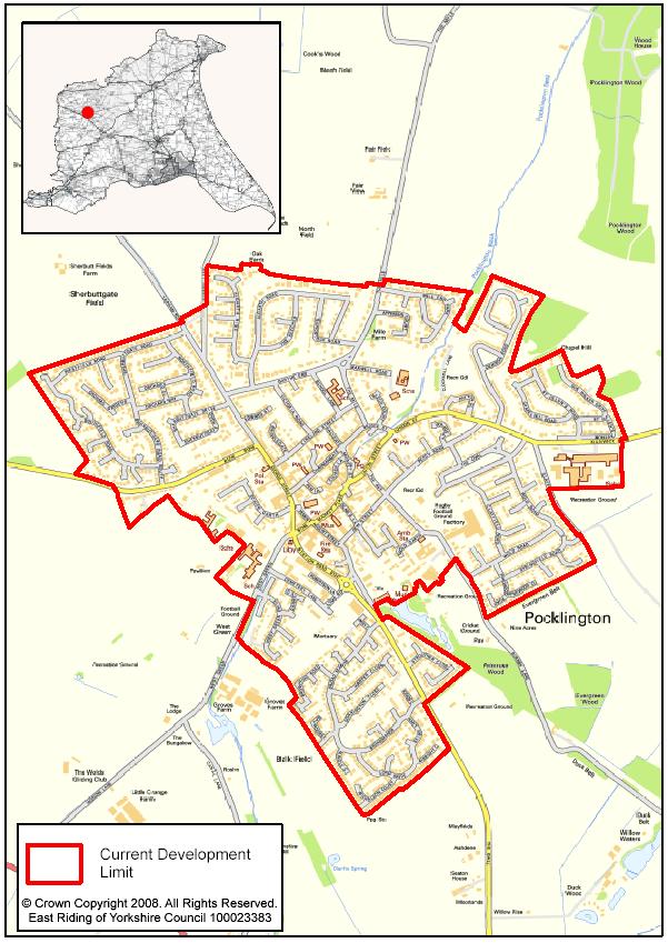
1 Settlement Profile of POCKLINGTON Copyright Ian Lavender and licensed for reuse under this Creative Commons Licence (Attribution-Share Alike 2.0 Generic) Pocklington is a small market town located approximately one mile north of the A1079 York to Hull Road. The town is approximately 13 miles east of York at the foot of the Yorkshire Wolds western escarpment and is a centre for local services and community facilities serving a wide rural area. A 15th-century church tower dominates the town s skyline whilst the architecture of the town is a mixture of quaint old houses and modern buildings with several unusual street names reflecting its history from the Iron Age onwards. The largely invisible Pocklington Beck, a small stream that feeds into the Pocklington canal, bisects the centre of the town. Pocklington Industrial Estate, which is used for light industrial uses, and Pocklington Business Park, used for commercial uses, are both large sources of employment for the surrounding area. The former RAF Airfield, which closed in September 1946, has three concrete and tarmac runways, gliders - and occasionally hot air balloonists now use the site.
2 Demographics Please note that all figures marked with a * are taken from the 2001 Census. They should be treated with a degree of caution as they are a number of years old. However, the Census remains the best dataset available for consistent and robust comparisons of small areas. 1 Population: 7, ,113* 52,041,916* (2.4% of East Riding total)* 2 Ages ,545 (20.2%)* (18.8%)* (20.2%)* 3 Ages (9.5%)* (9.1%)* (10.9%)* 4 Ages ,085 (27.3%)* (26.2%)* (29.2%)* 5 Ages ,843 (24.1%)* (27.5%)* (23.8%)* 6 Ages 65+ 1,432 (18.8%)* (18.4%)* (16.0%)* Employment and Economic 7 Economically Active - Employed (proportion of residents aged 16 to 74): 8 Economically Active - Unemployed (proportion of residents aged 16 to 74): 9 Economically Inactive (proportion of residents aged 16 to 74): 3,583 (66.8%)* (61.5%)* (60.6%)* 103 (1.9%)* (3.0%)* (3.4%)* 1,577 (29.4%)* (33.3%)* (33.5%)* 10 Employed in manufacturing 593 (16.1%)* (16.4%)* (15.0%)* 11 Employed in education, health and 960 (26.1%)* (27.1%)* (24.3%)* public admin. 12 Employed in agriculture, hunting or 107 (2.9%)* (4.4%)* (1.5%)* forestry 13 Employed in retail, hotels and catering 838 (22.8%)* (21.6%)* (21.6%)* 14 Employed in financial and business 482 (13.1%)* (11.4%)* (17.7%)* services 15 Employed in transport, storage and 249 (6.8%)* (6.2%)* (7.0%)* communication 16 Employed in other 445 (12.1%)* (12.9%)* (12.9%)* 17 Managerial and professional 1,471 (27.4%)* (25.9%)* (27.1%)* occupations 18 Intermediate occupations 526 (9.8%)* (8.6%)* (9.4%)* 19 Small employers and own-account 397 (7.4%)* (8.3%)* (7.0%)* workers 20 Lower supervisory and technical 396 (7.4%)* (7.9%)* (7.2%)* occupations 21 Semi routine and routine occupations 1,302 (24.3%)* (21.4%)* (20.8%)* 22 Never worked and long-term 82 (1.5%)* (2.5%)* (3.74%)* unemployed 23 Not classified and full time students 1,186 (22.1%)* (25.3%)* (24.9%)* 24 Employment locations (including undeveloped allocations): The town centre accommodates a relatively high number of jobs within the parish boundary. In addition, Pocklington Industrial Estate (in the parish of Barmby Moor) supports a high number of businesses which provide jobs for the residents of Pocklington and the surrounding area. Approximately 42 Ha of land remains undeveloped on the Estate which was a former RAF airfield and camp. Stage 2 of the Employment Land Review identified a need to retain the existing undeveloped allocations at Pocklington Industrial Estate.
3 25 Number of jobs in parish 2,877* Households and Housing 26 Total number of dwellings: 3,324 (2.4% of East 136,537* 22,481,305* Riding total)* 27 Detached houses and bungalows 1,301 (39.1%)* (33.4%)* (22.8%)* 28 Semi-detached houses and bungalows 1,068 (32.1%)* (37.4%)* (31.6%)* 29 Terraced houses and bungalows 622 (18.7%)* (19.9%)* (26.0%)* 30 Flat/maisonette/apartment 333 (10.0%)* (8.8%)* (18.8%)* 31 Caravan/Temporary structure 0 (0.0%)* (0.4%)* (0.4%)* 32 Rented from local authority/rsl/ha 388 (12.0%)* (9.0%)* (13.2%)* 33 Private rented stock 329 (10.2%)* (1.6%)* (5.9%)* 34 Number of dwellings built between 314 9, & 2008 (financial year parish): 35 Outstanding commitments (01/04/08) (parish): 157 5, Capacity of outstanding allocations: POCK4 Highways Depot, Cemetery Lane Est. capacity: 30 (remaining with permission - started) 37 Capacity identified in SHLAA: TBC TBC - 38 Identified housing need: 42 per annum 1,455 per annum - 39 Average house price (Jan-Dec 2007): 190,651 (YO42 2) 154, , Average house price change ( % 53.9% 39.5% 2007): 41 Housing market sub-area: Wolds Deprivation and Prosperity 42 Lowest ranked (least deprived) IMD SOA: 43 Highest ranked (most deprived) IMD SOA: 30,552 32,397 32,482 (southern part of (South Hunsley) Pocklington) 15,773 (central part of Pocklington) 758 (Bridlington South) 44 Average household income: 27,473-36,458 33,168 X 45 Number of households without a car or 689 (21.3%)* (20.2%)* (26.8%)* van 46 Number of households with 1 car or 1,581 (48.9%)* (46.0%)* (43.8%)* vans 47 Number of households with 2 cars or 803 (24.9%)* (27.1%)* (23.6%)* vans 48 Number of households with 3 or more cars or vans 158 (4.9%)* (6.6%)* (5.9%)* 49 Regeneration Strategy category Category 3 Wolds Market Towns Services and Facilities 50 Shopping areas: Shopping area centred around Market Place and Market Street 51 Nearest supermarket (km): Somerfield (George Street) Sainsbury s (The Balk Co-op (Market Street) 52 Retail hierarchy status: East Riding Retail Study is to be published in Autumn Markets: Pocklington Market (Tuesdays) 54 Community services and facilities: Pocklington has a library, a Customer Service Centre, a post office, several public 1
4 (see also below) houses and meeting rooms, two building societies and various general shops. The town also has multiple services sector outlets in the main shopping area. 55 Primary school(s): Pocklington Community Junior School St Mary and St Joseph RC VA Primary School 56 Nearest Secondary school(s): Woldgate School 57 Capacity of schools: Pocklington Community Junior School 320 (286 currently on roll 2007/08) St Mary and St Joseph RC VA Primary School 112 (99 currently on roll 2007/08) Woldgate School 1,450 (1,301 currently on roll 2007/08) 58 Nearest college/sixth form: Woldgate School 59 Health facilities: Hospitals York Hospital (A&E) 14 miles Nearest alternatives: Beverley Westwood Hospital 19 miles Castle Hill Hospital 21.5 miles GP Surgeries Pocklington Group Practice, Barmby Road Nearest alternatives: Market Weighton Surgery, Londesborough Road, Market Weighton 7 miles Holme-Bubwith Medical Group, Rush View, Holme on Spalding Moor 10 miles Dental Practices Pocklington NHS Dental Access Centre, Market Place The Regent Street Dental Practice, Regent Street Burnby Lane Dental Practice, Burnby Lane Nearest alternatives: Pharmacies Boots, Market Place Alliance Pharmacy, The Pavement Nearest alternatives: 60 Leisure and cultural facilities: Burnby Lane Cricket Ground Stewart Bowling Club Burnby Lane Pocklington Karate Centre Burnby Lane Francis Scaife Sports Centre Burnby Lane Pocklington AFC The Balk Pocklington RUFC Burnby Lane Pocklingotn Tennis Club West Green Montys Skateboard Park Carr Lane Kilnwick Percy Golf Club Millington Lane 61 Recreation areas: 63 Tourist facilities/accommodation: Burnby Hall Garden and Museum St James Church, Warter Allerthorpe Picnic Area, Golf Course and Lake Madhyamaka Buddhist Centre Millington Wood Paws-A-While Farm Mohair Farm Guest House Laburnham Cottage B&B, Millington The Feathers Hotel 64 Infrastructure capacity and constraints: CJ Strevens, Viking Road, Stamford Bridge 8.5 miles Boots, Market Place, Market Weighton 7 miles Transport and Accessibility 65 Strategic highway access (any identified Accessed from A1079 network constraints): 66 Rail network access: Nearest station: York 14 miles 67 Public transport provision (Bus): EYMS: X46, X47 (limited service), 744, 743, Distance by road to nearest Regional or York 14 miles (38 mins by bus)
5 Sub Regional City (time taken on public transport): 69 Distance by road to nearest Principal Town (time taken on public transport): Hull 28 miles (1 hr 16 mins by bus) Beverley 18 miles (39 mins by bus) 70 Average distance of travel to work 18.98* (11.8 miles) 17.75* (11 miles) 13.39* (8.3 miles) (km): 71 Travel to work by public transport 173 (4.7%)* (4.7%)* (14.5%)* 72 Travel to work by 2,382 (64.8%)* (69.5%)* (63.1%)* car/motorcycle/van/taxi 73 Travel to work by bicycle or on foot 740 (20.1%)* (14.8%)* (12.8%)* 74 People who mainly work from home 359 (9.8%)* (10.3%)* (9.2%)* 75 Travel to Work Area York* Environmental Issues 76 Flood risk: The majority of the town is within an area defined as Flood Zone 1 (low risk). However, an area defined as Flood Zone 2 (medium risk) extends along Pocklington Beck at the southern end of the town into the centre. At the northern end of Pocklington north of Bridge Street the area around the Beck is defined as Flood Zone 3 (high risk). In the events of June 2007, between 20 and 50 properties were recorded as being flooded in the parish. 77 National designations: Pocklington Wood, to the north east, and Kilnwick Percy Wood to the east, are both designated Ancient Woodlands. 78 Local designations: None 79 Landscape character: (please see the Landscape Character Assessment and Detailed Assessments for further information) General North Bugthorpe/Bishop Wilton Wooded Raising Farmland (2C) Open Farmland East Southeast Pocklington Rising Farmland (2D) Open Farmland South and Southeast Newton upon Derwent, Wilberfoss Allerthorpe and Hayton Framland (1C), Flat Open Farmland West - West Pocklington Farmland (1D) Flat Open Farmland Northwest Full Sutton and Fangfoss Farmland (2B) Open Farmland Detailed 1. Airfield; Ordinary to poor landscape quality, the landform within this area is predominantly flat, consisting of medium sized fields under arable production. The major designed space in the area is the disused airfield. Pocklington Industrial Estate is built on part of the airfield. This forms an unattractive and dominant landscape feature and is a major landscape detractor. Another major land use in the area is the school playing fields on the western edge of Pocklington. The area beyond the existing developed fringe of Pocklington is fairly open and would be highly sensitive to development. The land adjacent to the industrial estate however has a high capacity for recreational uses. 2. Yapham Road; Ordinary landscape quality, the flat fields within this area are of a medium size and used for arable production. The landscape here is large scale with open views through the tall hedgerows out into the surrounding fields. Farmsteads are present in this area and incorporate brick buildings and large farm sheds which contribute to the rural setting of Pocklington. Due to the open aspect of the landscape and flat topography, this area would be highly sensitive to development and has limited capacity. 3. The Mile / Pocklington Beck; Good quality landscape, the flat medium sized fields within this area are used for arable production with scattered farmsteads the only buildings visible. Apart from agricultural use the other major land use within this area is the allotment gardens located to the west of The Mile road. Hedgerows are prominent both around the settlement edge, the allotments, along field boundaries and along the course of Pocklington Beck. There is no visible woodland in the area. Communications masts are a landscape detractor. Built residential and commercial development in this area would impact upon its rural character therefore the landscape in this area is assessed to have high sensitivity to residential and commercial built development. 4. Pocklington Wood / Chapel Hill / Brants; High quality landscape, this attractive transitional landscape at the bottom of the Yorkshire Wolds scarp slope consists mainly of medium sized
6 fields used for a mixture of arable, rough grazing and forestry. A small number of mature hedgerows that include hedgerow trees are found within the area. There is good views of the church, however two detractors are a communications mast and the water storage area. Due to the high quality character of this landscape it is highly sensitive to development that would impact on the characteristics that contribute to landscape quality, i.e. tree cover, views and land use. 5. Eastern Pocklington; Good to high landscape quality, the medium sized fields are used for both arable and pasture with some small areas of rough grazing. A large belt of woodland is located to the south of the area along the course of the dismantled railway. Hedgerows are found along the road side and there are some fragmented hedgerows along field boundaries. A major land use on the edge of the area is the large Pocklington school site and associated playing fields which border the open fields. The area to the north which is a high quality landscape would be highly sensitive and have limited capacity for development. Other areas to the south of the school and the Springfield Road estate would have a moderate sensitivity and capacity for development. 6. Southeast Pocklington Farmland; Ordinary landscape quality, the flat slightly undulating landscape consists of medium sized arable fields. No woodland is found within this area apart from occasional isolated clumps of trees in the mature tall hedgerows that form the field boundaries. Bright red roof tiles of a nearby residential development are a landscape detractor. The area would have a high sensitivity and low capacity for development that would contribute to or encourage urban sprawl. The area of Balk Field would have some capacity for residential development that maintains existing field patterns. 7. Devonshire Mill; Good to ordinary landscape quality, this generally flat landscape consists of small to medium sized fields used for arable production. The main landscape feature within the area is Pocklington Beck which runs north to south from the town to the now disused Pocklington Canal, south of the A1079. The area has a range of different scattered settlements and some woodland in Balk Field in the form of plantation blocks and mature trees line the beck. The area forms an important entrance to the town and the open fields help to separate the town from the A1079. The landscape would be highly sensitive and have limited capacity to development in the Barrow Flat s area between the A1079 and Canal Lane due to its open aspect and lack of vegetation cover. The landscape in the Balk Fields area, north of the beck and north of Groves Farm, would be of a medium sensitivity and have a higher capacity for development. 80 Quality of surrounding agricultural land: North and South Grade 2 (Best and most versatile) East and West Grade 3 81 Conservation areas: Conservation area was designated in 1994 and is yet to be appraised. Area is an x shape covering the centre of the town from number 82 London Street in the northeast, to Burnby Hall gardens up to the Pump House in the southeast, across to Pocklington School in the southwest and up to number 14 George Street in the northwest. 82 Identified brownfield sites suitable for redevelopment TBC Parish Plans, Local Views and Strategies Please note: The views and material referenced below have been included for information only and do not necessarily mean that they have the support of East Riding of Yorkshire Council Comments: Draft published: 27/08/2008 First published: 07/11/2008 Last updated: Change Log Row Change Origin Date 54 Customer Service Centre added Forward Planning 24/10/08 60 Kilnwick Percy Golf Club added Forward Planning 24/10/08 59 Health facilities destinations and distances revised Forward Planning 06/11/08
7
Settlement Profile of BARMBY MOOR
 Settlement Profile of BARMBY MOOR Copyright Andy Beecroft and licensed for reuse under this Creative Commons Licence (Attribution-Share Alike 2.0 Generic) The village of Barmby Moor is situated approximately
Pocklington Transport Strategy ( ) POCKLINGTON TRANSPORT STRATEGY
 POCKLINGTON TRANSPORT STRATEGY") POCKLINGTON TRANSPORT STRATEGY CONTENTS 1 Introduction... 3 2 The Local Context... 5 3 The Transport Network... 9 4 Travel Patterns and Trip Rates... 14 5 Consultation... 19 6 Potential Transport Improvements...
POCKLINGTON TRANSPORT STRATEGY CONTENTS 1 Introduction... 3 2 The Local Context... 5 3 The Transport Network... 9 4 Travel Patterns and Trip Rates... 14 5 Consultation... 19 6 Potential Transport Improvements...
Area Profile: Shipley Park, Horsley and Horsley Woodhouse, Smalley and Mapperley
 Area Profile: Shipley Park, Horsley and Horsley Woodhouse, Smalley and Mapperley The area of Shipley Park, Horsley and Horsley Woodhouse is located to the south of Amber Valley Borough, including the villages
Visual and Sensory Aspect
 Updated All Wales LANDMAP Statistics 2017 Visual and Sensory Aspect Final Report for Natural Resources Wales February 2018 Tel: 029 2043 7841 Email: sw@whiteconsultants.co.uk Web: www.whiteconsultants.co.uk
Airport Planning Area
 PLANNING AREA POLICIES l AIRPORT Airport Planning Area LOCATION AND CONTEXT The Airport Planning Area ( Airport area ) is a key part of Boise s economy and transportation network; it features a multi-purpose
This section of the Plan provides a general overview of the Smoky Mountain Region. It consists of the following four subsections:
 SECTION 3 COMMUNITY PROFILE This section of the Plan provides a general overview of the Smoky Mountain Region. It consists of the following four subsections: 3.1 Geography and the Environment 3.2 Population
PUBLIC CONSULTATION - THE PURPOSE
 PUBLIC CONSULTATION - THE PURPOSE ² To review the sites identified for housing development; ² To introduce new sites that have come forward since the last Public Consultation with potential for housing
Contents Manningham at a Glance... 6 Location and Area... 6 Manningham Activity Centres... 6 Manningham Suburbs... 6 Population... 8 Forecast... 9 For
 Contents Manningham at a Glance... 6 Location and Area... 6 Manningham Activity Centres... 6 Manningham Suburbs... 6 Population... 8 Forecast... 9 Forecast 2011 2036... 9 Population Forecast... 9 Gross
29 Plas Derwen. Exploring Abergavenny
 29 Plas Derwen Exploring Abergavenny Cover: rhythm 2 plas derwen EXPLORING ABERGAVENNY For several years the Abergavenny and District Civic Society has been studying the streets, spaces and buildings of
Oak Lodge, Nunburnholme, Pocklington, York, YO42 1QY
 Oak Lodge, Nunburnholme, Pocklington, York, YO42 1QY A substantial detached family house Impressive staircase and reception hall Four reception rooms Kitchen/breakfast room Cloakroom, laundry and utility
the balk POCKLINGTON EAST YORKSHIRE An exciting development of 3, 4 & 5 bedroom homes in the ideally located village of Pocklington, East Yorkshire
 the balk POCKLINGTON EAST YORKSHIRE An exciting development of 3, 4 & 5 bedroom homes in the ideally located village of Pocklington, East Yorkshire Welcome to The Balk, traditionally styled family homes
MARKET OUTLOOK. 01 Walkability & Accessibility 02 Infrastructure & Employment 03 Demographics 04 Residential Analysis 06 Rental Analysis
 MARKET OUTLOOK EAST LEPPINGTON Located within the rapidly expanding South West Growth Centre of Sydney, the East Leppington Precinct is well positioned to benefit from the region s strong infrastructure
RED HOUSE FARM NORTH NEWBALD, BEVERLEY, EAST YORKSHIRE
 RED HOUSE FARM NORTH NEWBALD, BEVERLEY, EAST YORKSHIRE Tel: 01653 697820 CHARTERED SURVEYORS AUCTIONEERS VALUERS LAND & ESTATE AGENTS FINE ART & FURNITURE RED HOUSE FARM NORTH NEWBALD BEVERLEY, EAST YORKSHIRE
Spadina Avenue Built Form Study Preliminary Report
 STAFF REPORT ACTION REQUIRED Spadina Avenue Built Form Study Preliminary Report Date: July 9, 2014 To: From: Wards: Reference Number: Toronto and East York Community Council Director, Community Planning,
MIDDLETON-on-the-WOLDS PARISH COUNCIL WELCOME PACK
 MIDDLETON-on-the-WOLDS PARISH COUNCIL WELCOME PACK Now that you have moved in to your new home you will probably find that a few facts about the village, its facilities and the surrounding area would not
URBAN DESIGN REPORT. Proposed Residential Development, Old Church Road, Caledon East
 Proposed Residential Development, Old Church Road, Caledon East TABLE CONTENTS: 1.0 DEVELOPMENT 1.1 Introduction-Analysis of Guiding Principles and Documents 1.2 Community Design and Architectural Design
Tourism 201 CHAPTER 10
 Tourism 201 CHAPTER 10 202 Doncaster Unitary Development Plan Tourism 203 Tourism INTRODUCTION 10.1 The increasing importance of tourism is recognised in the UDP by having its own chapter. The benefits
MARKET OUTLOOK. 01 Walkability & Accessibility 02 Infrastructure & Employment 03 Population & Demographics 04 Residential Market 05 Rental Market
 MARKET OUTLOOK BRAYBROOK Close to the city in Melbourne s growing west, access to jobs, services and relative affordability are attracting new residents to Braybrook and driving price growth. 01 Walkability
Infrastructure for Growth
 A passion to deliver a prosperous future Connecting North Cambridgeshire Infrastructure for Growth Infrastructure for growth Wisbech is the largest settlement in Fenland. The town and its hinterland has
GET CLOSER TO COMMUNITY VILLAGE RESERVE IN BYFORD HAS A LOT ON OFFER, BUT ONLY FOR A SELECT FEW.
 GET CLOSER TO COMMUNITY VILLAGE RESERVE IN BYFORD HAS A LOT ON OFFER, BUT ONLY FOR A SELECT FEW. Perth Byford Village Reserve is Byford s most centrally located land estate. Steps away from one of the
Land off Stonnal Grove, & Rowden Drive (Phase 1A), Lyndhurst Estate, Sutton Road, Erdington, Birmingham, B23 5US
, Lyndhurst Estate, Sutton Road, Erdington, Birmingham, B23 5US") Committee Date: 07/03/2013 Application Number: 2013/00204/PA Accepted: 11/01/2013 Application Type: Reserved Matters Target Date: 12/04/2013 Development Ward: Erdington Land off Stonnal Grove, & Rowden
Committee Date: 07/03/2013 Application Number: 2013/00204/PA Accepted: 11/01/2013 Application Type: Reserved Matters Target Date: 12/04/2013 Development Ward: Erdington Land off Stonnal Grove, & Rowden
OUTLOOK EAST LEPPINGTON
 OUTLOOK EAST LEPPINGTON A CONTEXT ON BUSINESS, CULTURE, LIFESTYLE AND RESIDENTIAL Located within the rapidly expanding South West Growth Centre of Sydney, the East Leppington Precinct is well positioned
JOINT CORE STRATEGY FOR BROADLAND, NORWICH AND SOUTH NORFOLK EXAMINATION MATTER 3C EASTON/COSTESSEY
 Matter 3C Easton/Costessey Representor No. 8826 JOINT CORE STRATEGY FOR BROADLAND, NORWICH AND SOUTH NORFOLK EXAMINATION MATTER 3C EASTON/COSTESSEY SUBMISSION ON BEHALF OF TAYLOR WIMPEY DEVELOPMENTS AND
31 Barmby Road, Pocklington, York, YO42 2DL
 31 Barmby Road, Pocklington, York, YO42 2DL Victorian end terrace Sitting room & dining room Large breakfast kitchen Downstairs shower room Conservatory Five bedrooms House bathroom Delightful garden Double
GROWTH AREA PROFILES CITY CENTRES. Henderson. Past. g r o w t h management s t r a t e g y. Henderson 1940
 CITY CENTRES Past In 1940 was still a relatively small rural service town, surrounded by established vineyards and orchards, the Borough having a total population of approximately 1,500 people. By the
Site Assessment Report
 Nuthurst Parish Council Neighbourhood Plan Site Assessment Report September 2014 Produced by the Nuthurst Parish Neighbourhood Plan Steering Committee Page 1 of 12 1. Purpose The purpose of this report
Sainsburys Store, Mere Green Road, Sutton Coldfield, Birmingham, B75 5BT
 Committee Date: 7/0/013 Application Number: 013/04/PA Accepted: 1/04/013 Application Type: Variation of Condition Target Date: 1/07/013 Ward: Sutton Four Oaks Sainsburys Store, Mere Green Road, Sutton
SUBURBPROFILE POPULATION TO DOUBLE OV E RVIE W CITY OF WY ND H AM FORECAST POPULATION WYNDHAM CITY COUNCIL
 TA R NI E T 1 SUBURBPROFILE The suburb is located within the boundaries of the City of Wyndham which is one of the fastest growing municipalities in Victoria and the third fastest in Australia. OV E RVIE
VISUAL Impact Assessment
 5.0 Existing Landscape Character TO GOULBURN FEDERAL HIGHWAY 5.1 Landscape Character Units Generally one of the first steps in carrying out a landscape and visual assessment is to identify and map the
Public Realm & Landscape
 Town Centre Context Public Realm & Landscape 1. Public realm in the Town Centre varies significantly in quality. Areas of particularly good quality public realm are located around the Minster and outside
3. The Built Heritage
 3. The Built Heritage Archaeology There are individual and clusters of bronze/iron age barrows on the surrounding Wolds within the parish. The West of the Parish contains the line of the Roman Road to
SUMMER VILLAGE OF SILVER SANDS. Municipal Development Plan
 SUMMER VILLAGE OF SILVER SANDS Municipal Development Plan Bylaw 253-2014 Adopted August 22, 2014 Summer Village of Silver Sands Municipal Development Plan Bylaw No. 253-2014 Page 2 1 INTRODUCTION 1.1 SETTING
RAY YENKANA Willowbrook Cr, Dawson Creek BC Canada $2,847,000
 1716 Willowbrook Cr, Dawson Creek BC Canada For SALE $2,847,000 This is a rare find, 32 townhomes in Dawson Creek, BC. Excellent investment in a single title multi family complex. Vendor has upgraded this
Reference: 06/13/0594/F Parish: Fritton & St Olaves Officer: Mrs M Pieterman Expiry Date:
 Schedule of Planning Applications Committee Date: 21 st January 2014 Reference: 06/13/0594/F Parish: Fritton & St Olaves Officer: Mrs M Pieterman Expiry Date: 20-01-2014 Applicant: Proposal: Site: Lord
ASCOT SUBURB PROFILE
 ASCOT SUBURB PROFILE CONTENTS SUBURB HIGHLIGHTS 2 3 4 4 5 5 ASCOT & SURROUNDS LOCATION & LIFESTYLE DEMOGRAPHICS EMPLOYMENT FUTURE INFRASTRUCTURE WA MARKET TRENDS ACCESSIBILITY ENTERTAINMENT & RECREATION
STONES CORNER SUBURBPROFILE. Situated three kilometres from the Brisbane CBD, Stones Corner is located within one of Brisbane s key growth areas.
 1 SUBURBPROFILE Situated three kilometres from the Brisbane CBD, Stones Corner is located within one of Brisbane s key growth areas. OVERVIEW Situated three kilometres from the Brisbane CBD, Stones Corner
D R A F T M I N U T E S
 2016/27 CUDDINGTON PARISH COUNCIL Draft Minutes of Parish Council Meeting held in The Bernard Hall Monday 8 th August 2016 at 7.30pm PRESENT: Ken Birkby (KB), Ken Brown (KMB), Stuart Anderson (SA), Barbara
NEW RETAIL OPPORTUNITIES
 NEW RETAIL OPPORTUNITIES STAGE 1 LEASING NOW Join Coles, Kmart and ALDI plus 50+ Specialty Stores and Dining Precinct THE PORT S NEWEST RETAIL DEVELOPMENT The redevelopment of the Port Canal Shopping Centre
HEALTH SECTOR ECONOMIC INDICATORS REPORT
 HEALTH SECTOR ECONOMIC INDICATORS REPORT For: Mid North Coast Local Health District Report prepared by: April 2013 Table of Contents Introduction 3 Executive Summary 4 Output 5 Value-Added 7 Workforce
7 Knowsley. 7.1 Location and administration
 7 Knowsley 7.1 Location and administration The Metropolitan Borough of Knowsley is a metropolitan borough of Merseyside, covering some 86.17km 2. Knowsley comprises a belt of small towns, suburbs and countryside,
Key. Cotswold Water Park
 Existing Key Nature Sites Core Biodiversity Corridor Proposed Canals Biodiversity Scope The development of the CWP will be orientated towards meeting and exceeding biodiversity targets, making the CWP
Produced by: Destination Research Sergi Jarques, Director
 Produced by: Destination Research Sergi Jarques, Director Economic Impact of Tourism North Norfolk District - 2016 Contents Page Summary Results 2 Contextual analysis 4 Volume of Tourism 7 Staying Visitors
Produced by: Destination Research Sergi Jarques, Director
 Produced by: Destination Research Sergi Jarques, Director Economic Impact of Tourism Norfolk - 2016 Contents Page Summary Results 2 Contextual analysis 4 Volume of Tourism 7 Staying Visitors - Accommodation
APPENDIX 8. Leeds Socio-Economic Baseline Report. Report. July Metro and Leeds City Council
 APPENDIX 8 Leeds Socio-Economic Baseline Report Report July 2009 Prepared for: Prepared by: Metro and Leeds City Council Steer Davies Gleave West Riding House 67 Albion Street Leeds LS1 5AA +44 (0)113
The Sunshine Coast is part of the global community and generates wealth through export, high-value industries and new investment.
 3.2 Strategic intent 3.2.1 Shaping growth an overview In 2031, the Sunshine Coast is renowned for its vibrant economy, ecological values, unique character and strong sense of community. It is Australia
East Melbourne Precinct HO2. March 2015
 East Melbourne Precinct HO2 March 2015 Local Heritage Planning Policy Review Statements of Significance Melbourne s Local Heritage Planning Policy Review project includes the preparation of statements
Supporting information to an application for preapplication 3 rd February 2017
 Development Services, West Lindsey District Council, Guildhall, Marshall s Yard, Gainsborough DN21 2NA Supporting information to an application for preapplication advice. 3 rd February 2017 Proposal for
CITY RAIL LINK. New Public Transport Stations and Development Opportunities at Karangahape Road, Newton and Aotea Quarter
 134 AC_BEU_CCMP_3_TM5_8_FD.indd 134 20/07/12 12:30 PM 05 CITY RAIL LINK New Public Transport Stations and Development Opportunities at Karangahape Road, Newton and Aotea Quarter 5 MO VE 0 1 2 8 KEY 1 Britomart
Baslow & Bubnell Page 1 of 5 A Comparison
 Baslow & Bubnell Page 1 of 5 Introduction This paper describes the number of houses in Baslow and Bubnell from 1670 up to the present day. Most of the data was obtained by counting the buildings on a series
West of England. Priority Places Requiring Public Investment
 West of England Priority Places Requiring Public Investment Development Urban Regeneration & Suburban Intensification Bristol Central Area Bristol Central Area; Stokes Croft, Temple Meads & St Philips
A TRIBECA AREA FACT FILE
 03 A TRIBECA AREA FACT FILE SOUTH WEST MELBOURNE FOCUS AREA: TARNEIT AREA PROFILE AREA PROFILE: This report encompasses the South West Melbourne growth precinct of Wyndham. Specifically, the demographic
TAYplan SDPA. Main Issues Report. Options for Scotland s s SusTAYnable Region (Strategic Development Planning Authority)
") TAYplan SDPA (Strategic Development Planning Authority) Main Issues Report Options for Scotland s s SusTAYnable Region 2012-2032 2032 Content 1. The Development Plan System in Scotland 2. TAYplan in Context
TAYplan SDPA (Strategic Development Planning Authority) Main Issues Report Options for Scotland s s SusTAYnable Region 2012-2032 2032 Content 1. The Development Plan System in Scotland 2. TAYplan in Context
The Economic Impact of Tourism on the District of Thanet 2011
 The Economic Impact of Tourism on the District of Thanet 2011 Prepared by: Tourism South East Research Unit 40 Chamberlayne Road Eastleigh Hampshire SO50 5JH CONTENTS 1. Summary of Results 1 2. Table of
Schedule of Planning Applications Committee Date: 23 May Reference: 06/18/0064/F Great Yarmouth Officer: Mr J Beck Expiry Date:
 Schedule of Planning Applications Committee Date: 23 May 2018 Reference: 06/18/0064/F Great Yarmouth Officer: Mr J Beck Expiry Date: 24-04-2018 Applicant: Proposal: Site: Mr Mavroudis Clear weather hoardings
Town of Oakfield Agricultural and Farmland Protection Plan
 SECTION III COMMUNITY OVERVIEW A. Regional Setting / Location The Town of Oakfield is located in the northwestern portion of Genesee County. Located west of New York's Finger Lakes, the Town is uniquely
ISRAEL- COUNTRY FACTS
 ISRAEL- COUNTRY FACTS ISRAEL-NEIGHBOURING COUNTRIES AND POLITICAL MAP Area: 22,072 sq. km Land area: 21,643 sq. km. Fast Facts Area of lakes: 429 sq. km. (Sea of Galilee 164 sq. km., the Dead Sea - 265
ON BEHALF OF CENTRAL BEDFORDSHIRE COUNCIL DEVELOPMENT OPPORTUNITY DOWNING VIEW, 1-3 LORING ROAD, DUNSTABLE LU6 1DZ
 ON BEHALF OF CENTRAL BEDFORDSHIRE COUNCIL DEVELOPMENT OPPORTUNITY DOWNING VIEW, 1-3 LORING ROAD, DUNSTABLE LU6 1DZ Former Local Authority care home Approx 10,503 sq ft (976 sq m) gross internal area Site
Produced by: Destination Research Sergi Jarques, Director
 Produced by: Destination Research Sergi Jarques, Director Economic Impact of Tourism Norfolk - 2017 Contents Page Summary Results 2 Contextual analysis 4 Volume of Tourism 7 Staying Visitors - Accommodation
Date: 11 th January, From: Plaistow & Ifold Parish Neighbourhood Plan - Steering Group. Plaistow & Ifold Parish Council
 Date: 11 th January, 2017 From: Plaistow & Ifold Parish Neighbourhood Plan - Steering Group To: Plaistow & Ifold Parish Council Re: Neighbourhood Plan Report to Parish Council Meeting 17 Jan 2017 The Steering
21.07 ECONOMIC DEVELOPMENT AND EMPLOYMENT 19/03/2015 C323 Proposed C Key issues and influences. Economic Role and Function
 21.07 ECONOMIC DEVELOPMENT AND EMPLOYMENT 19/03/2015 C323 Proposed C347 21.07-1 Key issues and influences 14/10/2010 C168 Economic Role and Function Geelong is the largest regional city in Victoria and
Produced by: Destination Research Sergi Jarques, Director
 Produced by: Destination Research Sergi Jarques, Director Economic Impact of Tourism Oxfordshire - 2016 Economic Impact of Tourism Headline Figures Oxfordshire - 2016 number of trips (day & staying) 27,592,106
ENTER EXCEPTIONAL RESIDENTIAL DEVELOPMENT OPPORTUNITY
 FOR SALE Aviator Park, Station Road, Addlestone, Surrey KT15 2PG ibrochure - www.cbre-ibrochure.co.uk/addlestone ENTER EXCEPTIONAL RESIDENTIAL DEVELOPMENT OPPORTUNITY LOCATED WITHIN THE HIGHLY DESIRABLE
Produced by: Destination Research Sergi Jarques, Director
 Produced by: Destination Research Sergi Jarques, Director Economic Impact of Tourism Oxfordshire - 2015 Economic Impact of Tourism Headline Figures Oxfordshire - 2015 Total number of trips (day & staying)
Produced by: Destination Research Sergi Jarques, Director
 Produced by: Destination Research Sergi Jarques, Director Economic Impact of Tourism Epping Forest - 2014 Economic Impact of Tourism Headline Figures Epping Forest - 2014 Total number of trips (day & staying)
Classification of products and productive activities for tourism
 Classification of products and productive activities for tourism Developing National Systems of Tourism Statistics: Challenges and Good Practices Regional Workshop for the CIS countries, 29 June 2 July
Future Economy. Future Econo. Conditions for Growth. Conditions for Growth. Growth for Business. Growth for Business. Isles of Scilly.
 Isles of Scilly Evidence Base Future Economy Future Economy Conditions for Growth Conditions for Growth Growth for Business Growth for Business Future Econo CONTENTS Introduction... 3 Economic Overview...
Figure 1.1 St. John s Location. 2.0 Overview/Structure
 St. John s Region 1.0 Introduction Newfoundland and Labrador s most dominant service centre, St. John s (population = 100,645) is also the province s capital and largest community (Government of Newfoundland
North & West Melbourne Precinct HO3. March 2015
 North & West Melbourne Precinct HO3 March 2015 Local Heritage Planning Policy Review Statements of Significance Melbourne s Local Heritage Planning Policy Review project includes the preparation of statements
Land for Sale near Watford, Hertfordshire Land on Old House Lane, Kings Langley, Hertfordshire, WD4 8RS
 v1.0 01727 701303 www.vantageland.co.uk Land for Sale near Watford, Hertfordshire Land on Old House Lane, Kings Langley, Hertfordshire, WD4 8RS Arable land for sale with investment potential well situated
Depot. Chapel. El Sub Sta. 43 to 53 to to m
 BLANK PAGE 34 50 8 54 3 67 9 to 9 88 40 to 6 8 LONG RO 8 Depot 9 to 6 4 to 8 3 6 JOHN 8 Chapel 6 Works 3 7 to 4 5 4 6 William Dalby Walk 8 0 6 35 9 5 4 99 97 95 93 89 9 85 87 UNSTON ROAD 07.0m 4 El Sub
Hazlet. 1. Overview of Hazlet and Its Waterfront. Hazlet Township. 1.1 Geographic Overview
 Hazlet 1. Overview of Hazlet and Its Waterfront 1.1 Geographic Overview Hazlet Township is located in Monmouth County. The Township has a land area of 5.6 square miles. Situated in the Bayshore region
SKIDBY PARISH COUNCIL MINUTES OF THE ORDINARY MEETING OF THE COUNCIL HELD IN THE VILLAGE HALL, MAIN STREET, SKIDBY TUESDAY 9 JANUARY 2018
 SKIDBY PARISH COUNCIL MINUTES OF THE ORDINARY MEETING OF THE COUNCIL HELD IN THE VILLAGE HALL, MAIN STREET, SKIDBY TUESDAY 9 JANUARY 2018 PRESENT Councillors P Browning (In the Chair), H Crane, G Foster,
PEMBROKESHIRE & CORNWALL VISITOR SURVEYS 2011/12 COMPARING THE DESTINATIONS. February 2013
 PEMBROKESHIRE & CORNWALL VISITOR SURVEYS 2011/12 COMPARING THE DESTINATIONS February 2013 Prepared for: Visit / Destination Pembrokeshire Partnership Client Contact: Emma Rojano/ Mark Horner TERMS OF CONTRACT
Inverness, Culloden and Suburbs Settlement Economic Overview
 Strategic planning and research Economic information December 2007 Inverness, Culloden and Suburbs Settlement Economic Overview Summary Between 2001 and 2006, the population of Inverness, Culloden and
System Improvements & Future Needs
 June 2005 System Improvements & Future Needs Ian Coles - Data & Systems Coordinator JMP Consulting 2005 JMP Consulting on behalf of the TRICS Consortium TRICS System Improvements & Future Needs New features
Bridge School, Longmoor Campus, Coppice View Road, Sutton Coldfield, Birmingham, B73 6UE
 Committee Date: 22/01/2015 Application Number: 2014/05949/PA Accepted: 08/12/2014 Application Type: Full Planning Target Date: 02/02/2015 Ward: Sutton Vesey Bridge School, Longmoor Campus, Coppice View
Hayfield in 1901: OTHER SHOPS. Type Employees Outlets
 An outing from the Bulls Head Inn circa 1910 showing the News Agents on left. Next door is one of Hayfield s many Butchers shops with an awning over the window. On the opposite side of the road is the
Figure San Dimas Bonita at San Dimas Avenue (view looking west)
") The adjoining neighborhood has an eclectic assortment of building types and uses, including: the historically significant but not architecturally or visually noteworthy San Dimas Lemon Association Packing
The adjoining neighborhood has an eclectic assortment of building types and uses, including: the historically significant but not architecturally or visually noteworthy San Dimas Lemon Association Packing
SIAVONGA DISTRICT
 SIAVONGA DISTRICT --------------------------------------------------------------------------------------------------------- 1.0 Physical Environment Siavonga District is characterized by an escarpment
Table of Contents TABLE OF CONTENTS. HOW THIS BY-LAW WORKS... i PART 1 - ADMINISTRATION, INTERPRETATION, ENFORCEMENT, AND DEFINITIONS
 TABLE OF CONTENTS Page Number HOW THIS BY-LAW WORKS... i PART 1 - ADMINISTRATION, INTERPRETATION, ENFORCEMENT, AND DEFINITIONS 1.1 ADMINISTRATION, INTERPRETATION AND ENFORCEMENT... 1.1 ~ 1 to 6 1.1.1 Within
Sevierville, TN. Technical Appendices
 Sevierville, TN Technical Appendices 2017 2955 Valmont Road Suite 300 777 North Capitol Street NE Suite 500 Boulder, Colorado 80301 Washington, DC 20002 n-r-c.com 303-444-7863 icma.org 800-745-8780 Contents
Farrow Barn, Pocklington Lane, Huggate, York, YO42 1YJ
 Farrow Barn, Pocklington Lane, Huggate, York, YO42 1YJ Fabulous detached barn conversion Popular village location Stunning sitting room/dining room Bespoke breakfast kitchen Utility room Four double bedrooms
SOUTH WORCESTERSHIRE DEVELOPMENT PLAN - PREFERRED OPTIONS 2011: SCHEDULE OF ISSUES AND RECOMMENDED RESPONSES Row No.
 1. Inadequate justification Existing retail floor space is underused so no point in extending retail floor space. Instead, would prefer to have sympathetic housing development in the City Centre to attract
TOWN PLANNING SUBMISSION TO THE GREATER SYDNEY COMMISSION LANDS AT ARTARMON
 TOWN PLANNING SUBMISSION TO THE GREATER SYDNEY COMMISSION LANDS AT ARTARMON March 2017 TABLE OF CONTENTS 1.0 INTRODUCTION 3 2.0 THE SUBJECT SITE 4 3.0 STRATEGIC PLANNING CONTEXT 6 4.0 SUMMARY AND CONCLUSIONS
Tinker Air Force Base, Oklahoma
 Table 5.4 Generalized Zoning within the Tinker AFB Clear Zones and Accident Potential Zones (Off-Installation) Category Acreage Residential 1,486 Commercial 191 Industrial 128 Public/Quasi-public 0 Recreational/Open/Agricultural/Low
The Travel and Tourism Industry in Vermont. A Benchmark Study of the Economic Impact of Visitor Expenditures on the Vermont Economy 2005
 The Travel and Tourism Industry in Vermont A Benchmark Study of the Economic Impact of Visitor Expenditures on the Vermont Economy 2005 INTRODUCTION GENERAL November, 2006 This 2005 update of the original
 Appendix A Gerrans Parish Profile The Parish of Gerrans covers an area of 1375ha 1. Formerly the two parishes of Gerrans and St Anthony, it lies north-south along the eastern side of the Roseland peninsula.
The Economic Impact of Tourism on Calderdale Prepared by: Tourism South East Research Unit 40 Chamberlayne Road Eastleigh Hampshire SO50 5JH
 The Economic Impact of Tourism on Calderdale 2015 Prepared by: Tourism South East Research Unit 40 Chamberlayne Road Eastleigh Hampshire SO50 5JH CONTENTS 1. Summary of Results 1 2. Table of Results Table
317a & 400 Hoe Street, Walthamstow, E17 9AA
 North East London Residential Led Development Opportunity 317a & 400 Hoe Street, Walthamstow, E17 9AA Red line boundary for indicative purposes only Summary Residential-led two-site development opportunity
Part Three : COMMUNITY PLAN AREAS AND SPECIAL STUDY AREAS SACRAMENTO 2030 GENERAL PLAN. Introduction
 Special study Areas Part Three : COMMUNITY PLAN AREAS AND SPECIAL STUDY AREAS SACRAMENTO 2030 GENERAL PLAN Introduction Beyond the boundaries of the 2030 General Plan, the City has defined Special Study
Chapter 1: The Population of NHS Greater Glasgow and Clyde
 Population Estimate (thousands) Chapter 1: The Population of NHS Greater Glasgow and Clyde Population Trends and Projections National Records of Scotland estimated (NRS SAPE) 1 the 2013 NHS Greater Glasgow
MLS # $202, Acres residential development site in Bay County, Florida
 MLS # 617466 $202,000 35.31 Acres residential development site in Bay County, Florida Highway 231 Fountain, FL Presented By: Don Nations Nations Real Estate 2325-A Frankford Avenue, Suite A Panama City,
Warwick District Council plans 100 houses in. Radford Semele
 Page I (This information circular is issued by Radford Semele Parish Council) Warwick District Council plans 100 houses in Radford Semele 1.1 Warwick District Council will make a decision during 2014 on
Economic Impact Analysis. Tourism on Tasmania s King Island
 Economic Impact Analysis Tourism on Tasmania s King Island i Economic Impact Analysis Tourism on Tasmania s King Island This project has been conducted by REMPLAN Project Team Matthew Nichol Principal
HOUSEHOLD TRAVEL SURVEY
 HOUSEHOLD TRAVEL SURVEY Household Travel Survey i TABLE OF CONTENTS Page 1.0 INTRODUCTION... 1 2.0 SUMMARY OF TRAVEL... 2 2.1 All-Day Travel Patterns... 2 2.1.1 Automobile Availability... 2 2.1.2 Trip
PCAL Case Study Retail Areas: Rouse Hill Town Centre
 PCAL Case Study Retail Areas: Rouse Hill Town Centre Introduction Rouse Hill Town Centre is a new mixed use development on a greenfield site in Sydney s North West. It has been planned to be a major hub
At a meeting of the Development Management Committee held on 22 February 2018
 1 HAVANT BOROUGH COUNCIL At a meeting of the held on Present Councillor Keast (Chairman) Councillors Buckley, Hughes, Keast, Perry, Satchwell, Lloyd and Guest (Standing Deputy) 105 Apologies for Absence
The Economic Impact of Tourism on Scarborough District 2014
 The Economic Impact of Tourism on Scarborough District 2014 Prepared by: Tourism South East Research Unit 40 Chamberlayne Road Eastleigh Hampshire SO50 5JH CONTENTS 1. Summary of Results 1 2. Table of
2.0 Physical Characteristics
 _ 2.0 Physical Characteristics 2.1 Existing Land Use for the Project The site is comprised of approximately 114 acres bounded by Highway 101 to the north, the existing town of Los Alamos to the east, State
LORD HOWE ISLAND MARINE PARK PROFILE OF LOCAL BUSINESSES. Department of Environment Climate Change & Water. Prepared For: Prepared By:
 LORD HOWE ISLAND MARINE PARK PROFILE OF LOCAL BUSINESSES Prepared For: Department of Environment Climate Change & Water Prepared By: Arche Consulting Pty Ltd Version: June 2010 Arche Consulting T + 61