In 1922, the Road Commission hoped to keep the roads open for automobiles until January 1 and only for horse sleigh after that.
|
|
|
- Emily Armstrong
- 6 years ago
- Views:
Transcription
1 Roads. The Houghton County Road Commission was born on April 4, 1910 as the county electorate voted 7,100 for and 989 against a Good Roads System, established in order to develop an organized improvement and expansion of roads in Houghton County. Up until this year, only haphazard improvement of wagon roads into the country, and between population centers and the copper mining areas existed. The advent of the Model T Ford, of which fewer than 1,000 vehicles existed in Houghton County in 1910, created the impetus to develop a meaningful road system. Offices for the Road Commission were opened in rented quarters in downtown Hancock with personnel of six employees. Equipment consisted of three Pierce Arrow plows, a Model T Ford, one motorcycle, and five other truck vehicles. Late in 1911, the offices were moved to the Shelden Dee building in Houghton. The Board of Road Commissioners began their road building responsibilities with a budget of $29,051.00, provided by the County Board of Supervisors. The first priorities for road improvements were to reconstruct and straighten the route between the two major population centers of Hancock and Calumet. The first road project was to improve the highway between Mesnard and the Rhode Island Mine. The early years concentrated on developing the highways at the perimeter of the population centers for the purpose of serving the mining needs and also to create a system of farm to market roads, the first of which was the Otter Lake Road, into south Houghton County. As the Road Commission improved the major routes, the state reimbursed them a portion of that cost and then designated those roads as state trunk line and paid for their maintenance. The first Road Commission members, appointed by the County Board of Supervisors, were Chairman F.J. McLain, and members E.S. Grierson and Theodore Dengler. The first County Highway Engineer was Randolf Martin. Houghton County Road Commission came into being by vote April 4, On their web page they say Before then only haphazard improvement of wagon roads into the county and between population centers and mine areas existed. With the advent of the Model T Fords, there were 1000 vehicles in Houghton County in The Houghton Hancock Bridge reported in 1915 there were 491 teams and 993 cars crossing. In 1925 there were 85 teams and 4897 cars. The early years had the Road Commission developing the roads, which were to eventually, become state trunk line highways while individual townships and cities were developing the remainder of the roads in Houghton County. The completion of a road between Marquette and Houghton initiated the placing of the first tourist road signs by the Copper Country Commercial Club in The year 1917 brought the first news headlines about two collisions on one weekend, along with the first arrest and $10.00 fine of an Alston man for drunk driving, after a wild zigzag journey across the Houghton County bridge.
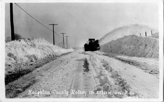
2 In 1919, the Road Commission replaced the horses, which pulled large snow rollers with tractors. Four teams of horses used to pull the snow roller. Richard Garnell of North Superior Road says he used to operate the horses and roller on the Houghton Canal and Heinola Roads after a bad snowstorm. He had 3 teams of horses. Teamsters worked the machine and horses. He got $5 for working a 10-hour day. Our team of horses was purchased from the Village of Houghton were former fire horses, which pulled fire wagons in the summer and rollers in the winter. A news article stated, while the tractors are slower than horses, 2 M.P.H. vs. 4 M.P.H., they do not tire in the large drifts and will make the round-trip between Hancock and Calumet in one day. In 1922, the Road Commission hoped to keep the roads open for automobiles until January 1 and only for horse sleigh after that. In 1923, the Road Commission moved their headquarters from Houghton and the Shelden Dee building to the Lake Superior Smelting Works property in Ripley, where some equipment and materials were already being stored. Road use changed dramatically between 1915 and 1925 as daily traffic counts on the Houghton-Hancock Bridge changed from 491 teams and 993 cars in 1915 to 85 teams and 4,897 cars in In 1926, the Road Commission hired the first motorcycle officer, Bud Kennedy, to patrol the county roads. In 1927, the first trunk lines are kept open for the entire winter. In 1931 the McNitt Act passed. It mandated that the County Road Commission shall absorb 20 percent of all township roads each year, until all 653 miles had been made county roads. In 1934, the Road Commission experienced the heaviest period of activity in its history, as 4,731 Civil Works Administration employees were on the payroll. Today, the responsibility of the Road Commission exists much as it did in the late 1930's, to maintain, with Michigan Transportation Funds, some 858 miles of county roads outside of the limits of the seven incorporated cities and villages. ROAD information around Oskar. The following paragraph was taken from MTU Archives Bill Brinkman Collection In the first and second decades of this century, the townships all had their own highway

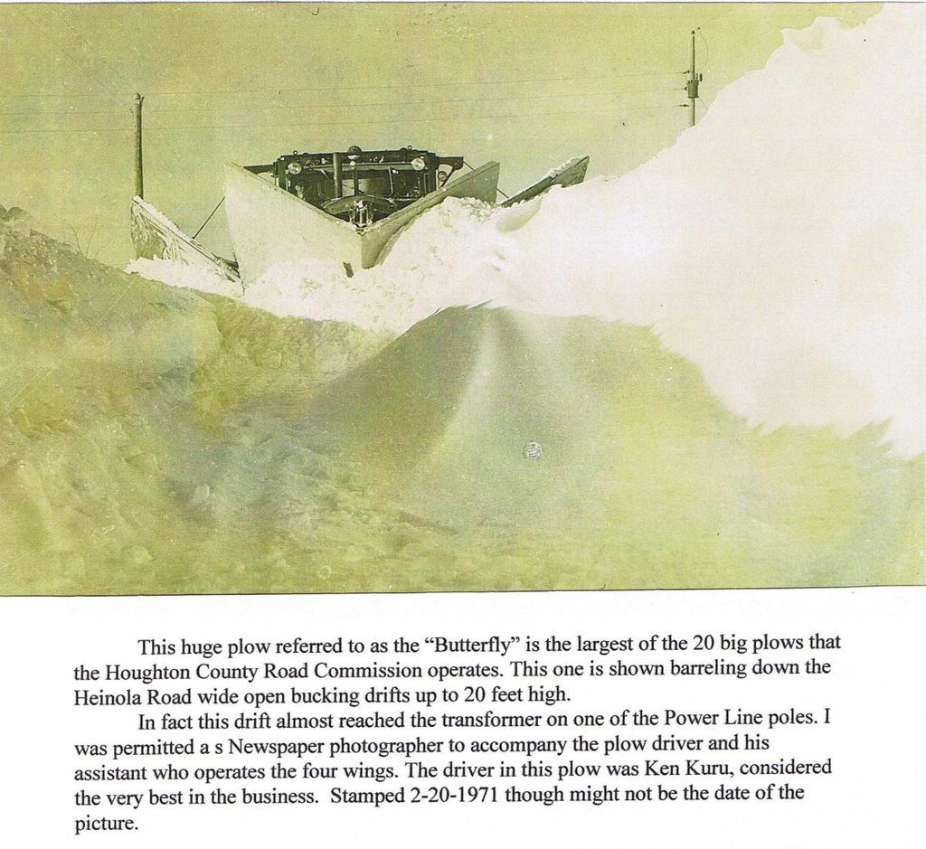
3 departments. The Road Commission says April 4, 1910 that the county took over the entire highway building and maintenance. A Gazette photo of the snow roller used to pank down highway snows belonged to the Stanton Township Highway Department. Various local farmers drove it on a day wage basis and contained sand or other heavy material. From 1880 right up to 1930 the roads were primarily used by horses and sleighs and buggies. But in the mid 1920 s the Houghton County Road Commission started to use motorized plows and even a snow blower in 1921 experimentally. It was a very primitive machine. A photo was taken by a member of the Zurcher family in front of their home. (Mel Anderson s home in 2009) Richard Garnell has a photo from the 1985 Gazette: Fifty years ago (1935), they didn t push snow around in the winter time, but just packed it down with rollers like this one in Osceola...Four teams of horses were used to the machine. The rollers were large on either side of the machine.. the middle was open. In 1919 the Commission replaced the horse drawn snow rollers with tractors. Richard wrote on photo - Richard Garnell used to pack snow with the same kind of roller on the Oskar Canal and Heinola area after a bad snowstorm. Three teams of horses always pulled the roller. The teamsters (drivers) were paid $5 for a hour day. Our team of horses was purchased from the Village of Houghton. They were former fire horses, which pulled fire wagons in the summer and sleighs in the winter. The daughters of Hannah Romppainen, Marie Tuohimaa and Florence Suo, share: that the North Superior Road was first named the Relief Road as the WPA (Works Project
4 Administration) built the road. Growing up the Romppainens lived off the Relief Road North Superior (Road Commission named it ST-51 H) was aligned with Bay Shore Rd (Government Pit or 553E) but did not come thru to meet it. The East West Road turned South just past the Red Barn Road (ST 61) coming out in Olson s farm south of the School. Richard Garnell shares: The N. Superior Road did not come thru as it does today. It stopped / began at the Red Barn Road by his and parent s home. The road we call N. Superior that begins at the Houghton Canal Road to the Red Barn Road was built by people on relief. (WPA). They could use no mechanical tools.. only their shovels and teams of horses. Art Kelly s mother and father and Art lived on the Relief Road and helped with construction during the depression. See Kelly document. The Works Project Administration was in operation from 1935 to 1942 under Franklin D. Roosevelt. Robert Karinen sketched a trail.. Later to be the North Superior/Relief Road going east directly across the Houghton Canal Road though it was not there then. He says this was a crossing where the old military trail went to Fort Wilkins. Abraham Lincoln in 1864 designated the Military Road from Green Bay to Fort Wilkins. Mike Karinen shares that the Military Road was the mail route on the North Superior Road and across the now Canal Road, East over where the canal eventually was dug. This was near the Olson / now Jon Dunstan Farm. (Other resources say the military road was in Houghton area not here) The Houghton Canal road (553) was a wagon trail at first. Before the dredging of the North Entry the road went around the lake to Hancock side. At this time the Canal Road went between Selma/Eino Lantto s property and Andrew Reikki s property then onto the now Bay Shore Road and around the end of the Canal water. The location of the road changed westward after the canal was dredged in late 1800 s. Bucky Ovist s deed says they got an easement in 1916 and I think that connected the old canal road to the present day canal road. Look at Plat Maps section. The original Osma Plat road (Kelly s road) was a driveway, a two track, which began at the present day Bucky Ovist driveway. Kelly s road came down thru the field on high ground, back to Lantto s transformer behind now Fulayter s present home. The transformer was south of the road and the Lantto dairy barn was on the North side of road. The road went thru the Andrew Reikki property after the Selma/Eino Lantto property and in now Frair s grove of trees next to open pasture. It continued south of now road to the Andrew Krapu farm (Frairs now) by going down the now Nelson driveway. It turned to the left and went past cottages to Kelly and Kalliainen property in One can see the remains of the first road between Bettinson/Traub and Koski properties. The road moved back (1956?) towards the swamp/west s property to have more room behind cottages. A 1938 drawing from the Houghton Co. Road Commission says of our now Osma Plat. It is named Road ST-653 D. Described as: Southeast off of 653 (Canal Road) from the Northeast quarter of Section 5. T55 R34. This drawing states: at 0.00 leave Co. Rd farmhouse on left (Ovists now) and enter farm (of Selma/Eino Lantto) Farm house on right (Selma Lantto), Barn on left (dairy barn) curve left curve right curve left road right to farmhouse and cottage (now Nelson s driveway to Juntunen?) turn left trail right cottage
5 right road right to cottage Road right to cottage road right to cottage turn right farm house on right (Kelly?). End of Road Red Brick Road: (553C) Old timers said Indians had an encampment on the point where Deric Garnell lives now at end of Red Brick Road. Garnells found arrowheads and fire pits. Barb recalls Deric s dad, Henry, showing her a framed display of arrowheads found on his farm. Robert Karinen sketched 2 clay pits alongside (North side) the Red Brick Road. They used the clay to make bricks for the Charcoal kilns. Paul Frair tells of 2 pits on his property but they are filled in. Bob Olson says they used to call this road Brick Yard Road. See document under Oskar area Businesses on the North Canal Brick Factory. Bay Shore Road: Was called Government Pit Road, as there is a gravel pit on the road. The old Houghton Canal Road went thru the Waara /Lampainen property around the canal before dredging to the Hancock Canal. Winter Road. Richard Garnell shares: There was a winter road across the ice from the Houghton Canal to the Hancock Beach area. Horse and sleighs would cross there. One time he recalls his dad Alex Garnell telling him to get off sleigh and walk beside the horses. If it appeared the ice would not hold the horses, he was supposed to pull the pin to separate them from sleigh. They never did go thru the ice luckily. Mel Anderson tells of their neighbor the Webers using the road to go to church and the horse and buggy went thru the ice. Mr. died and she survived. Road to N. Superior Road from Oskar. This trail went up behind Ruohonens, Yotti, Garnell, and Johnson to N. Superior. This might have been a railroad grade of Oscar Eliassen s at one time. See map in Chapter of Oskar. Heinola Road from Oskar. This road went up from near today s Kevin Ruohonens to Heinola. This might have been a railroad grade of Oscar Eliassen s at one time. See map in Chapter of Oskar. Michigan Highway History Before it was a state highway, many parts of the original route of M-26 were used as a military road, connecting Fort Wilkins at Copper Harbor with Fort Howard at Green Bay, Wisconsin. Menominee County: The Military Road started out as a "tote" road for lumberjacks carrying supplies from Shawano north to the camps. In the early days of the Civil War, the North had no way of transporting troops from Fort Howard at Green Bay to Fort Wilkins in Keweenaw County, Michigan. On March 3, 1863 Congress passed an act approving the roads construction. The construction was paid for with land grants, three sections for each mile of completed road.
6 This road opened up the northern pineries for the early lumbermen and the economy of Shawano. From 1919 until 1934, M-26 was routed southward to the Wisconsin state line to a connection with along what is now US 45. The original northern terminus of M-26 was in Laurium Michigan at M-15 Michigan highway (now US 41). It was extended in September 1926 along US 41 to Mohawk Michigan and then replacing M-83 Michigan highway to Gay Michigan. This extension would be reversed in July 1933 when the Mohawk to Gay routing is turned over to Keweenaw County control. A second extension in 1935 along US 41 to Phoenix replaced M-129 Michigan highway between Phoenix and Eagle Harbor. At this time, M-206 Michigan highway was designated from M-26 to the Eagle Harbor light house. A rerouting of M-26 in November 1940 moved it between Phoenix and Eagle River, replacing M-111 Michigan highway. The segment between Phoenix and Eagle River along Copper Falls Mine Road was turned over to Keweenaw County at this time. In 1979, M-26 was rerouted through Dakota Heights Michigan", bisecting it. Park Avenue had formerly served as the main route from Houghton to Atlantic Mine Michigan, but this was replaced by the new route of the highway. In September of 2006, the Michigan Department of Transportation opened a bypass around the southwest and southern edge of South Range Michigan" in order to provide a safer route through the town. As of 2006 October 4, MDOT has transferred jurisdiction of the necessary pieces of roadway to complete the M-26 bypass of South Range. After 1938, the M-111 designation was given to an old M-6 Michigan highway" routing in the Keweenaw Peninsula that ran between Eagle River Michigan" and Phoenix Michigan along what is, now, modern-day M-26 parallel to Eagle River. That incarnation lasted two years until M-111 was deleted and M-26 was realigned over it. The M-111 designation has not been used since being deleted in M-206 was a state highway that served as a spur route from M-26 into Eagle Harbor and the/eagle Harbor Lighthouse in Keweenaw County in 1935.

7 North Stanton Township road map.


8 Winter Roads over the canal were common for horse and buggy.. today snowmobiles make roads. One winter road was near Gedvillas Road to the Hancock Park. Roads over the Salmon Trout in Redridge over the years. Red is first road. Green is 2 nd road, yellow is present road location.

9
10

11 Researched by Barb Koski Osma Plat Road Houghton MI in Submitted Contact Webmaster with other stories.
Crossing the Keweenaw Waterway in an Emergency with a U.S Army Floating Bridge
 Crossing the Keweenaw Waterway in an Emergency with a U.S Army Floating Bridge Photo: John Kiefer William Leder, Adjunct Professor (Ret.) Department of Civil and Environmental Engineering Contributions
Wilkins, Nevada A 20 th Century Ghost Town
 Howard Hickson s Histories Wilkins, Nevada A 20 th Century Ghost Town Wilkins looks like a war zone today. There is nothing there except burned ruins in the sagebrush. It is a far cry from the vital days
COPPER HERITAGE TRAIL CONCEPTUAL PLAN 2011
 COPPER HERITAGE TRAIL CONCEPTUAL PLAN 2011 A Proposed 40 Mile Non-Motorized Rail Trail Route Connecting The Historic Communities Of the Copper Country Prepared For: Western Upper Peninsula Health Department
Fort Wilkins Natural History Association P.O. Box 104 Copper Harbor, MI 49918
 Fort Wilkins Natural History Association P.O. Box 104 Copper Harbor, MI 49918 Photo Courtesy of www.michigan.org January 2013 Happy 2013 from the Fort Wilkins Natural History Association! We look forward
TOWN OF OSCEOLA BOARD OF SUPERVISORS MEETING Tuesday October 3, 2017 MINUTES
 TOWN OF OSCEOLA BOARD OF SUPERVISORS MEETING Tuesday Page 1 of 5 MINUTES The Board of Supervisors of the Town of Osceola met for a regular monthly meeting Tuesday October 3, 2017 at 7:00 p.m. at the Osceola
Schoolcraft Township is located in northeast Houghton County. A portion of the township borders Keweenaw County and Lake Superior.
 COMMUNITY DESCRIPTION Schoolcraft Township is located in northeast Houghton County. A portion of the township borders Keweenaw County and Lake Superior. The township is largely rural but has one main population
Mayor Robert Backon, Mayor Pro Tem Robert Megowen, Councilors Rachel Lankton, Craig Kurtz, Gernot Joachim, Mike Needham, and Daniel Salo.
 REGULAR MEETING HOUGHTON CITY COUNCIL WEDNESDAY, SEPTEMBER 14, 2011 5:30 p.m. CITY COUNCIL CHAMBERS, CITY CENTER PRESENT: Mayor Robert Backon, Mayor Pro Tem Robert Megowen, Councilors Rachel Lankton, Craig
A bridge on Chicago Road over Little Indian Creek is currently scheduled for rehab, but may be replaced
 This Transcript was taken 11/18/1999 From a speech by John A. Wilson - County Board Member & Chairman of the Public Infrastructure & Development Committee at the Township Officials Fall Meeting Jetting
4th Grade Third 9 Weeks Test
 4th Grade Third 9 Weeks Test Multiple Choice Identify the choice that best completes the statement or answers the question. 1 A waterway for ships that is dug across land is called a. A port C river B
COLDSPRINGS TOWNSHIP REGULAR BOARD MEETING MINUTES COLDSPRINGS TOWNSHIP HALL-COUNTY ROAD 571
 COLDSPRINGS TOWNSHIP REGULAR BOARD MEETING MINUTES COLDSPRINGS TOWNSHIP HALL-COUNTY ROAD 571 JUNE 12, 2006 7:00 P.M. Supervisor Neubecker called the meeting to order at 7:00 p.m. Pledge of Allegiance was
CHAPTER FOUR: TRANSPORTATION
 CHAPTER FOUR: TRANSPORTATION Barron County Comprehensive Plan: Transportation Page 61 Background Transportation facilities have a significant influence on land use, development and quality of life for
1/17/15. As we move into the New Year, I want to pause and look back on some of our shared accomplishments from this past year.
 RICK SNYDER GOVERNOR STATE OF MICHIGAN DEPARTMENT OF NATURAL RESOURCES LANSING KEITH CREAGH DIRECTOR 1/17/15 FWNHA Members PO Box 104 Copper Harbor, MI 49918 Dear FWNHA Members, SUBJECT: Fort Wilkins Historic
Big Sable Point Lighthouse Les & Arlene Meverden Ludington, MI 49431
 Les & Arlene Meverden Ludington, MI 49431 My Interview with Les and Arlene Meverden and their daughter Janet was held on June 5, 2004. I first learned about the Meverden family through an article published
ACCESS INVENTORY AND IMPROVEMENT PLAN
 ACCESS INVENTOR AND IMPROVEMENT PLAN Prepared by: Western Upper Peninsula Planning & Development Region Financial Assistance for the project was provided, in part, by the Michigan Coastal Management Program,
Welcome to the Midwest!
 Welcome to the Midwest! Why do we call the Midwest "America's Heartland"? 5 9 7 4 2 Farm State 6 8 1 St. Louis 3 St. Louis, Missouri "Gateway to the West" Frontier: the beginning of unexplored land Pioneers:
NORTHEAST CARLTON COUNTY BICYCLE ROUTE PLAN
 NORTHEAST CARLTON COUNTY BICYCLE ROUTE PLAN 5/31/2014 and St. Louis River Trail Plan Update Produced by the Arrowhead Regional Development Commission (ARDC) in Partnership with the State Health Improvement
CHAPTER 5: Operations Plan
 CHAPTER 5: Operations Plan Report Prepared by: Contents 5 OPERATIONS PLAN... 5-1 5.1 Proposed Service Changes... 5-2 5.1.1 Fiscal Year 2017... 5-2 5.1.2 Fiscal Year 2018... 5-6 5.1.3 Fiscal Year 2019...
Nancy Ryan, Transfer Station Clerk, met with the Board first to go over the Transfer Station Budget.
 Supervisor Jenkins opened the workshop at 6:30 p.m. Town Board Members Present Tom Cumm Councilman Preston Jenkins Councilman Todd Kusnierz Councilman (arrived at 6:42 p.m.) [At the meeting of 10/13/09
Mayor Robert Backon, Mayor Pro Tem Robert Megowen, Councilors Rachel Lankton, Craig Kurtz, Gernot Joachim, and Mike Needham.
 REGULAR MEETING HOUGHTON CITY COUNCIL WEDNESDAY, JUNE 22, 2011 5:30 p.m. CITY COUNCIL CHAMBERS, CITY CENTER PRESENT: Mayor Robert Backon, Mayor Pro Tem Robert Megowen, Councilors Rachel Lankton, Craig
Mayor Robert Backon, Mayor Pro Tem Robert Megowen, Councilors Gernot Joachim, Craig Kurtz, Mike Needham, and Dan Salo.
 REGULAR MEETING HOUGHTON CITY COUNCIL WEDNESDAY, MARCH 26, 2014 5:30 p.m. CITY COUNCIL CHAMBERS, CITY CENTER PRESENT: Mayor Robert Backon, Mayor Pro Tem Robert Megowen, Councilors Gernot Joachim, Craig
Public Notice ISSUED: December 10, 2018 EXPIRES: January 9, 2019
 APPLICANT: REFER TO: St. Louis and Lake Counties Regional Rail Authority 2018-01942-ARC Public Notice ISSUED: December 10, 2018 EXPIRES: January 9, 2019 SECTION:404 - Clean Water Act 1. APPLICATION FOR
Non-Motorized Transportation
 Non-Motorized Transportation Non-motorized facilities are important components to the transportation system. They provide an environmentally-friendly, low-cost mode of travel. Some of the facilities can
Mayor Robert Backon, Mayor Pro Tem Robert Megowen, Councilors Rachel Lankton, Craig Kurtz, Gernot Joachim, Mike Needham, and Daniel Salo.
 REGULAR MEETING HOUGHTON CITY COUNCIL WEDNESDAY, JULY 27, 2011 5:30 p.m. CITY COUNCIL CHAMBERS, CITY CENTER PRESENT: Mayor Robert Backon, Mayor Pro Tem Robert Megowen, Councilors Rachel Lankton, Craig
APPROVED MINUTES Public Works Commission November 10, 2010
 APPROVED MINUTES Public Works Commission November 10, 2010 Members Present: Members Absent: Alternate Present: Staff Present: Charles Bishop, Arthur Benson, Robert Guadagno and Patrick Kinney Dean Mitchell
Tourism Update Presented to the City Council of Elizabeth City August 25, 2014
 Tourism Update Presented to the City Council of Elizabeth City August 25, 2014 Tourism Economic Impact Tourism is a multimillion dollar industry in Elizabeth City In 2013, domestic tourism in Pasquotank
Lake Erie Commerce Center Traffic Analysis
 LOCATION: East of NYS Route 5 at Bayview Road Town of Hamburg Erie County, New York PREPARED BY: Wendel Companies 140 John James Audubon Parkway Suite 200 Amherst, New York 14228 January 2012 i ii Table
Ordinance Number Snowmobiles and ATVs. Replaces pages See also Section County ATV Ordinance.
 Ordinance Number 05-2009 Snowmobiles and ATVs Replaces pages 900-28 - 900-29 See also Section 905.2.2 County ATV Ordinance Amended 02-15-11 ORDINANCE NO. 05-2009 WHEREAS, the use of snowmobiles and All
Department of Public Works
 Department of Public Works History Introduction The Department of Public Works was established as a department under the newly formed County Manager System of government for Henrico Country in 1934. It
The Original Farm, Dairy & Sausage plant buildings
 The Original Farm, Dairy & Sausage plant buildings Featured below are images of the original Deerfoot farm buildings along Stony Brook. Beginning in 1894, the original farm buildings along with 20 acres
S Central Coast Heritage Protection Act APRIL 21, 2016
 STATEMENT OF GLENN CASAMASSA ASSOCIATE DEPUTY CHIEF, NATIONAL FOREST SYSTEM U.S. FOREST SERVICE U.S. DEPARTMENT OF AGRICULTURE BEFORE THE UNITED STATES SENATE COMMITTEE ON ENERGY AND NATURAL RESOURCES
Map 2. Industrial Parks, Cass County
 Map 2. Industrial Parks, Cass County Marcellus 1 Dowagiac Grand Trunk Western Railroad Amtrak Railroad Cassopolis 2 3 Vandalia Howard Twp. State Hwy 60 Edwardsburg 5 4 Ontwa Twp. US Hwy 12 6 ID Name 1
WEDNESDAY, SEPTEMBER 2, 2015, COUNCIL CHAMBERS, AVON CITY HALL
 WEDNESDAY, SEPTEMBER 2, 2015, COUNCIL CHAMBERS, AVON CITY HALL The meeting was called to order at 7:00 P.M. by Chairman Randy Fratianne. Present: Bruce Klingshirn; Mark Ladegaard; Chauncey Miller; Kurt
United States Department of the Interior National Park Service. Boundary Expansion Listed in National Register January 11, 2017
 NPS Form 10900-a (Rev. 8/2002) OMB No. 10240018 United States Department of the Interior National Park Service Boundary Expansion Listed in National Register January 11, 2017 National Register of Historic
University Region Non-Motorized Plan 2015
 Non-Motorized Transportation Non-motorized facilities are important components to the transportation system. They provide an environmentally-friendly, low-cost mode of travel. Some of the facilities can
The Galveston Seawall
 Coastal and Ocean Engineering ENGI.8751 Undergraduate Student Forum Faculty of Engineering and Applied Science, Memorial University, St. John s, NL, Canada. March, 2013 The Galveston Seawall Mark Harvey
KENDALL COUNTY REGIONAL PLANNING COMMISSION. Kendall County Office Building Rooms 209 & W. Fox Street, Yorkville, Illinois
 KENDALL COUNTY REGIONAL PLANNING COMMISSION Kendall County Office Building Rooms 209 & 210 111 W. Fox Street, Yorkville, Illinois Meeting Minutes of September 24, 2014 (Unofficial until Approved) Chairman
MEETING MINUTES District 1 Trail Planning Meeting 1
 MEETING MINUTES District 1 Trail Planning Meeting 1 June 1, 2017 2:00 PM 3:30 PM City of Two Harbors 2:00 Introductions Attendees: Lisa Austin, MnDOT Bryan Anderson, MnDOT Jasna Hadzic-Stanek, MnDOT Justin
Chagrin Falls Steam and Interurban Railways
 Chagrin Falls Steam and Interurban Railways Steam Railways In 1877 there were 79,000 miles of railroad track across the US, but Chagrin Falls had none. Residents and business owners traveled to Solon to
Eli Pousson Baltimore Heritage in partnership with the National Trust for Historic Preservation May 27, 2010
 Eli Pousson Baltimore Heritage in partnership with the National Trust for Historic Preservation May 27, 2010 DRAFT Report on 3000 block of North Avenue DRAFT The Dr. Zepp Mansion is a late 19th century
M I N U T E S OKLAHOMA COUNTY PLANNING COMMISSION
 M I N U T E S OKLAHOMA COUNTY PLANNING COMMISSION March 18, 2004 1:30 p.m. The meeting of the Oklahoma County Planning Commission convened and was called to order by Mr. Will Jones, Vice-Chairperson, at
SUBJECT: Mark Twain Birth Site Trail - Supplement 1, Mark Twain Lake Master Plan, Design Memorandum No. 9, Salt River, Missouri
 CEMVS-PM-E MEMORANDUM FOR FILE SUBJECT: Mark Twain Birth Site Trail - Supplement 1, Mark Twain Lake Master Plan, Design Memorandum No. 9, Salt River, Missouri 1. Reference: a. ER 1130-2-550, Chapter 3:
KEWEENAW COUNTY ROADS WITH SEASONAL RESTRICTIONS
 KEWEENAW COUNTY ROADS WITH SEASONAL RESTRICTIONS ALLOUEZ TOWNSHIP PRIMARY ROADS WITH SEASONAL RESTRICTIONS 1ST STREET US 41 AHMEEK NUMBER SIX RD. 0.56 AHMEEK ST. NUMBER SIX RD. COUNTY LINE 0.39 BUMBLETOWN
KETTLEBOWL - Distance: Approximately 13 miles Highway 52 to Polar at Highway 64.
 LANGLADE COUNTY ICE AGE NATIONAL SCENIC TRAIL CONDITIONS (As of September 7, 2017) Due to situations beyond the control of the Langlade County Chapter of the Ice Age Trail Alliance, conditions are constantly
Mayor Robert Backon, Mayor Pro Tem Robert Megowen, Councilors Rachel Lankton, Craig Kurtz, Gernot Joachim, and Mike Needham.
 REGULAR MEETING HOUGHTON CITY COUNCIL WEDNESDAY, JULY 13, 2011 5:30 p.m. CITY COUNCIL CHAMBERS, CITY CENTER PRESENT: Mayor Robert Backon, Mayor Pro Tem Robert Megowen, Councilors Rachel Lankton, Craig
Traffic Safety Commission Meeting Minutes-Approved December 7, :00 am
 Traffic Safety Commission Meeting Minutes-Approved December 7, 201110:00 am Call to order: Meeting was called to order at 10:00 am by Highway Safety Coordinator Sheriff Nancy Hove Members present: Sheriff
NORTH BERWICK, MAINE, MINUTES OF PLANNING BOARD NOVEMBER 17, 2011
 1 NORTH BERWICK, MAINE, 03906 MINUTES OF PLANNING BOARD NOVEMBER 17, 2011 Present: Chairman R. Todd Hoffman, Barry Chase, Shaun DeWolf, Rick Reynolds and Lawrence Huntley, CEO. Absent: Mark Cahoon and
Capitol Hill Interviews
 Freda Murray was interviewed in 1974 to provide background for the application to create the Capitol Hill Historic District. Citation of this material should include this information and cite the Ruth
TOWN OF PERTH June 7, 2018 Regular Town Board Meeting 6:30 p.m.
 TOWN OF PERTH June 7, 2018 Regular Town Board Meeting 6:30 p.m. PRESENT: Supervisor Fagan, Councilman Korona, Councilman Lewandowski, Councilman Betz and Councilman Kowalczyk ALSO PRESENT: Town Clerk,
LANGLADE COUNTY ICE AGE NATIONAL SCENIC TRAIL CONDITIONS (As of May 18, 2017)
") LANGLADE COUNTY ICE AGE NATIONAL SCENIC TRAIL CONDITIONS (As of May 18, 2017) Due to situations beyond the control of the Langlade County Chapter of the Ice Age Trail Alliance, conditions are constantly
LANGLADE COUNTY ICE AGE NATIONAL SCENIC TRAIL CONDITIONS (As of May 18, 2017) Due to situations beyond the control of the Langlade County Chapter of the Ice Age Trail Alliance, conditions are constantly
Calendar. On the Common Templeton MA. April. Narragansett Historical Society. Events and Meetings for 2015
 Narragansett Historical Society April Calendar On the Common Templeton MA Events and Meetings for 2015 April 22nd Meeting 4th Wednesday 7pm at the Document room 26th May Day basket making at the Otter
A.M. Irene, how long has your family been farming in this area?
 Irene Jorgensen (in her home) Interviewed by Ann Melhaus February 11, 2005 A.M. Irene, how long has your family been farming in this area? Since 1913. A.M. Okay. And who acquired the farm, originally?
PLANNING COMMISSION MEETING MINUTES October 25, :00 p.m.
 PLANNING COMMISSION MEETING MINUTES 7:00 p.m. 1) Call to Order Commission members present: Chair Heck, Strandell, Warner, Sandholm, and Stulberg. Commission members absent: Pollmann, Watson. Staff present:
Saturday, June 17 to Sunday June 25, Stampede to Cody
 Saturday, June 17 to Sunday June 25, 2017 Stampede to Cody Wind River Canyon Wind River Canyon is a scenic Wyoming canyon carved out by the Wind River. It is located between the cities of Shoshoni and
CHAPTER 4 -- THE LAND USE PLAN: DESCRIPTIONS AND POLICIES FOR THIRTEEN PLANNING AREAS
 CHAPTER 4 -- THE LAND USE PLAN: DESCRIPTIONS AND POLICIES FOR THIRTEEN PLANNING AREAS NORTH CENTRAL CAC AREA LITTLE VALLEY ROAD TO JUG HANDLE CREEK PLANNING AREA This planning area includes Cleone, Noyo,
DATE COURSE TITLE LOCATION HOURS. February 27 Flow & Dynamics with Fluids, Hydraulics, and Pneumatics...Augusta *6 Sponsored by Motion Industries
 J o i n t E n v i r o n m e n t a l Tr a i n i n g C o o r d i n a t i n g C o m m i t t e e Winter/Spring 2018 JETCC Training Schedule DATE COURSE TITLE LOCATION HOURS February 22 Care of Emergency Generators...Orono
Early Living conditions in the Copper Country.
 1 Early Living conditions in the Copper Country. 1913 Kitchen Push your child around in the snow with a sleigh. 2 Shop at Redridge Market. An advertisement in Finnish newspaper was This is to announce
Weber Point The First Sammamish Lumber and Shingles
 Weber Point The bunkhouse picture is "Courtesy Issaquah History Museums, Neg. 2005.1.18" Weber Point, located on the eastern shores of Lake Sammamish in the northern part of the city of Sammamish, is today
Isle Royale Info Trip Packages. The Greenstone Ridge Trail
 s East Section West Section Total Miles 42.7 Difficulty East to West 6.884 Difficulty West to East 6.965 [This is based on 7 Day Shorter Miles sample itinerary. However, difficulty is close to the same
Finding aid for the Charles W. Darling photographs Collection 184
 Finding aid for the Charles W. Darling photographs Collection 184 Finding aid prepared by Richard Harms This finding aid was produced using the Archivists' Toolkit May 11, 2013 Describing Archives: A Content
MINUTES OF THE BOARD OF COUNTY ROAD COMMISSIONERS MONROE, MICHIGAN December 3, 2018
 MINUTES OF THE BOARD OF COUNTY ROAD COMMISSIONERS MONROE, MICHIGAN December 3, 2018 1. At a Regular Meeting of the Board of County Road Commissioners at their offices located at 840 S. Telegraph Road,
Board of Supervisors Meeting July 12, :30pm MEETING MINUTES
 Board of Supervisors Meeting 7:30pm MEETING MINUTES Board Members Present: Gary Painter-Chairman, Mimi Legro Vice Chair, Randy Braden- Supervisor Staff Present: Beth Graham Secretary/Ass t. Treasurer,
Aviation, Rail, & Trucking 6-1
 6-1 This chapter describes the services, facilities, and condition of air, rail, and trucking as components of the transportation system. These three intermodal areas have an impact on the factors to be
Proud of Our Heritage
 BEVERLY HOLOIDAY PIONEERS 11830 42 St., Edmonton, AB Interview with Joe at 3818 109 Ave on July 27, 1998 The First House My parents moved to Beverly in 1935. They rented 10 acres of land on 39 Street and
Osceola Township Recreation Plan
 Osceola Township Recreation Plan 2011-2015 Adopted January 13, 2011 Prepared for: Osceola Township P.O. Box 437 Dollar Bay, MI 49922 Prepared by: Western U.P. Planning & Development Region P.O. Box 365
Figure San Dimas Bonita at San Dimas Avenue (view looking west)
") The adjoining neighborhood has an eclectic assortment of building types and uses, including: the historically significant but not architecturally or visually noteworthy San Dimas Lemon Association Packing
The adjoining neighborhood has an eclectic assortment of building types and uses, including: the historically significant but not architecturally or visually noteworthy San Dimas Lemon Association Packing
MINUTES OF THE OAK CREEK PLAN COMMISSION MEETING TUESDAY, NOVEMBER 8, 2011
 MINUTES OF THE OAK CREEK PLAN COMMISSION MEETING TUESDAY, NOVEMBER 8, 2011 Mayor Bolender called the meeting to order at 7:00 p.m. The following Commissioners were present at roll call: Commissioner Dickmann,
PORTER COUNTY BOARD OF ZONING APPEALS HEARING OFFICER October 18, 2018 MEETING MINUTES
 County Administration Center 155 Indiana Avenue, Suite 311 Valparaiso, IN 46383 p: 219.465.3530 www.porterco.org PORTER COUNTY BOARD OF ZONING APPEALS HEARING OFFICER October 18, 2018 MEETING MINUTES LOCATION:
Personal History. Curiosity Creek on the end of Jenal Road in 2003 (USF) Curiosity Creek in 2003 (USF)
 Curiosity Creek in 2003 (USF)") Oral history narrative from a joint program with Hillsborough County and the Florida Center for Community Design and Research Curiosity Creek The following narrative comes from an interview with long-time
Oral history narrative from a joint program with Hillsborough County and the Florida Center for Community Design and Research Curiosity Creek The following narrative comes from an interview with long-time
glacier _G4U1W5_ indd 1 2/24/10 4:10:48 PM
 glacier Routine for Lesson Vocabulary Introduce This glacier is huge. A glacier is a great mass of ice moving very slowly down a mountain, along a valley, or over a land area. Let s say the word together:
Communication in the West and the Transcontinental Railroad!!!
 Communication in the West and the Transcontinental Railroad!!! What was communication like during Westward Expansion? If people wanted to get letters from the West back to the East, the fastest way was
FINANCE COMMITTEE MINUTES OF THE FEBRUARY 3, 2010 MEETING.
 FINANCE COMMITTEE MINUTES OF THE FEBRUARY 3, 2010 MEETING. Members attending: Mr. Fenton (Chairman), Mrs. Herron and Lennon, Major Ireland, Messrs. Lang, Runstrom, and Schur Non-members attending: Chris
Special Committee on U. S. Route Numbering
 Special Committee on U. S. Route Numbering Franklin, Tennessee- Franklin Marriott Cool Springs Monday May 21, 2018 5:30 PM (Central Daylight Time) Conference Call- Tel 1-888-585-9008, Conf. Room No. 191-374-518
Airport Planning Area
 PLANNING AREA POLICIES l AIRPORT Airport Planning Area LOCATION AND CONTEXT The Airport Planning Area ( Airport area ) is a key part of Boise s economy and transportation network; it features a multi-purpose
Rochester Avon Historical Society Research Reports
 Rochester Avon Historical Society Research Reports Research Report #9 Rochester Municipal Park (formerly Avon Park) March 2012 Rochester Avon Historical Society Rochester, Michigan www.rochesteravonhistoricalsociety.org
National No. 2 (Bob Ciminel 2012)
") National No. 2 (Bob Ciminel 2012) Coming timetable east out of Muse Junction, we begin ascending the 1% grade to National Tunnel at MP 27. After passing through the tunnel s 823-foot bore we begin our
National No. 2 (Bob Ciminel 2012) Coming timetable east out of Muse Junction, we begin ascending the 1% grade to National Tunnel at MP 27. After passing through the tunnel s 823-foot bore we begin our
Stage 2 - November 2017 Survey and Map Comments (verbatim)
") Stage 2 - November 2017 Survey and Map Comments (verbatim) Identifying information removed to meet Freedom of Information and Protection of Privacy Act (FOIP Act). Comments are recorded exactly as they
Stage 2 - November 2017 Survey and Map Comments (verbatim) Identifying information removed to meet Freedom of Information and Protection of Privacy Act (FOIP Act). Comments are recorded exactly as they
The Remains of the Ontario and Western Railway Fifty Years after Abandonment
 The Remains of the Ontario and Western Railway Fifty Years after Abandonment Oswego to Cadosia Drew James New York Ontario and Western Railway Oswego to Cadosia Oswego Fulton Pennellville Central Square
Iconic Pipher's Bar Little-Changed in 80 Years New Photos and Story by Rick Hiduk
 Iconic Pipher's Bar Little-Changed in 80 Years New Photos and Story by Rick Hiduk Pipher's Bar owner George Nesbit (left) wraps up his morning shift and hands over bartending duties to nine-year employee
MINUTES MACATAWA AREA COORDINATING COUNCIL TRANSPORTATION TECHNICAL COMMITTEE
 Policy Board Howard Baumann, Jr. Joseph Baumann Thomas Bird Nancy DeBoer Ken DeWeerdt Terry Hofmeyer Gerald Hunsburger John Kleinheksel Kevin Klynstra John Lanum Hannes Meyers, Jr. Terry Nienhuis Glenn
Priscilla Davenport, Saluda District
 AT A MEETING OF THE MIDDLESEX COUNTY PLANNING COMMISSION HELD ON THURSDAY, NOVEMBER 13, 2003, IN THE PUBLIC MEETING ROOM OF THE COOK S CORNER OFFICE COMPLEX, COOK S CORNER, VIRGINIA. Present: Absent: John
and tell their friends they had been on an outing, and that's the way Outing got its' name. Joseph C. Woods was a state senator during Theodore
 hot Cass County was created by an act of the legislature in 1851 and covers about 2440 square miles. The first county seat was near where Brainerd is now and later moved to Walker. The early roads followed
Celebrating 100 years in January Sunday Monday Tuesday Wednesday Thursday Friday Saturday. 5 6 New Year s Day City Offices Closed
 January 208 2 3 4 5 6 New Year s Day No refuse removed January 3 refuse today due to holiday. removed today. 7 8 9 * Recreation Board 6 pm 0 Beautification Commission 6 pm** 2 3 4 5 Martin Luther King,
Copper Country Trail National Byway Corridor Management Plan
 Copper Country Trail National Byway Corridor Management Plan Prepared for: Copper Country Trail National Byway Committee Prepared by: Western Upper Peninsula Planning & Development Region i ACKNOWLEDGEMENTS
Valley County Planning & Zoning Commission
 Valley County Planning & Zoning Commission Phone: 208.382.7115 PO Box 1350 Fax: 208.382.7119 219 North Main Street Email: cherrick@co.valley.id.us Cascade, ID 83611-1350 Website: www.co.valley.id.us Ed
Mankato s Transportation Heritage
 Mankato s Transportation Heritage City of Mankato Mankato Heritage Preservation Commission May 11, 2017 1. Union Depot, 112 S. Riverfront Drive, c. 1896. The railroads were Mankato s dominant transportation
The Superior Venture
 All-American Adventures The Superior Venture Explore the parks of Wisconsin, Michigan s upper peninsula, and Lake Superior s largest island Content was created by AAA in collaboration with the National
Interview with Pete Minneau Gladstone, Michigan No Date Given
 Interview with Pete Minneau Gladstone, Michigan No Date Given Pete Minneau (PM): I was born in 1914, I grew up in Gladstone, and I spent all of my life here. My father was a railroader. He came in here
Great Development Opportunity
 Great Development Opportunity NW Corner I-94 / 66th St. 3238 66th St. NE $2,600,000 - Approx. 40 Acres Proposed Interchange 80th St 66th St. 66th St. to Lincoln Future Residential New Multi-Family Development
Redesigning The Waterfront
 San Francisco Maritime National Park Service U.S. Department of the Interior National Historical Park California Redesigning The Waterfront A Self-Guided Walking Tour Then & Black Point Cove, ca. 1910.
LINWOOD TOWNSHIP ROAD & BRIDGE COMMITTEE January 3, :00 p.m.
 LINWOOD TOWNSHIP ROAD & BRIDGE COMMITTEE January 3, 2017 7:00 p.m. Present: Chairman Bob Beckman, Tom Sausen, Craig Bachman, Craig Rylander, Tammie Lukkonen, Ed Kramer Township Supervisor, Bob Millerbernd
PUBLIC SAFETY. FY 2015 BUDGET Prince William County CIP-PUBLIC SAFETY 551
 PUBLIC SAFETY FY 2015 BUDGET Prince William County CIP-PUBLIC SAFETY 551 PUBLIC SAFETY 552 CIP-PUBLIC SAFETY Prince William County FY 2015 BUDGET Bacon Race Station Total Project Cost - $11.2 M The station
Missing Link Snowmobile Club. Stonecliffe Trail September 15 th, 2017
 Missing Link Snowmobile Club Stonecliffe Trail September 15 th, 2017 Recap: 2017 Trail Changes In the fall of 2016, an opportunity presented itself for the snowmobile club to utilize a portion of the abandoned
Lawrence Loop SWOT Analysis
 Alignment: D1 (Map Color: Dark Blue) Description: This alignment connects to the north end of the Burroughs Creek Trail and continues along the west side of the Railroad to 8 th Street. Strengths: - This
IAT NS CAPE BRETON - NORTH SYDNEY TO PORT HASTINGS (SOUTHBOUND)
") NORTH SYDNEY TO GRAND NARROWS - 61.4 KM WELCOME TO NORTH SYDNEY, CAPE BRETON ISLAND, NOVA SCOTIA! North Sydney is a major city with a CAPs (public internet access) & all amenities. Rollies Wharf Restaurant
NORTH SYDNEY TO GRAND NARROWS - 61.4 KM WELCOME TO NORTH SYDNEY, CAPE BRETON ISLAND, NOVA SCOTIA! North Sydney is a major city with a CAPs (public internet access) & all amenities. Rollies Wharf Restaurant
TOWN OF EPPING, NEW HAMPSHIRE PLANNING BOARD MEETING. THURSDAY May 26, 2011
 TOWN OF EPPING, NEW HAMPSHIRE PLANNING BOARD MEETING THURSDAY May 26, 2011 PRESENT Mike Morasco, Steve Colby, Dave Crowell, Dave Reinhold; Selectmen s Representative Bob Jordan; Alternate Brian Reed; Planner
STATE ROUTE CHANGE DESCRIPTION USRN DECISION IOWA
 AASHTO Special Committee on U. S. Route Numbering (USRN) Report to the Standing Committee on Highways (SCOH) May 4, 2011 Decision and Meeting Minutes May 2, 2011 Las Vegas, Nevada Members: Chair Don Vaughn,
POLICY COORDINATING COMMITTEE
 Members Present: Councilman Dennis Pitman for Chairman Tom Hanel, Mayor, City of Billings; Commissioner Jim Reno, Board of County Commissioners; Dick Clark, Planning Board Ward V for Paul Gatzemeier, President,
MINUTES OF THE BOARD OF COUNTY ROAD COMMISSIONERS MONROE, MICHIGAN October 22, 2018
 MINUTES OF THE BOARD OF COUNTY ROAD COMMISSIONERS MONROE, MICHIGAN October 22, 2018 1. At a Regular Meeting of the Board of County Road Commissioners at their offices located at 840 S. Telegraph Road,
H 7766 AS AMENDED S T A T E O F R H O D E I S L A N D
 ======= LC0 ======= 0 -- H AS AMENDED S T A T E O F R H O D E I S L A N D IN GENERAL ASSEMBLY JANUARY SESSION, A.D. 0 A N A C T RELATING TO STATE AFFAIRS AND GOVERNMENT -- SOVEREIGNTY AND JURISDICTION
San Antonio's River Walk Behind the scenes tour or did you know?
 San Antonio's River Walk Behind the scenes tour or did you know? Robert B. Kauffman, Ph.D 7 Hill Top Drive Frostburg, MD 21532 o: (301) 687-4474 e: rkauffman@frostburg.edu All historical slides are from