Conwy Valley Flood Alleviation Scheme: Llanrwst, Gwynedd
|
|
|
- Amie Whitehead
- 5 years ago
- Views:
Transcription

1 873 Conwy Valley Flood Alleviation Scheme: Llanrwst, Gwynedd Archaeological Excavation GAT Project No Report No. 873 June, 2010 Ymddiriedolaeth Archaeolegol Gwynedd Gwynedd Archaeological Trust Craig Beuno, Ffordd y Garth, Bangor, Gwynedd, LL57 2RT
2 Archaeological Excavation: Demountable Trenches 1-3 Llanrwst Report No. 873 Prepared for The Environment Agency June 2010 By Robert Evans Ymddiriedolaeth Archaeolegol Gwynedd Gwynedd Archaeological Trust Craig Beuno, Ffordd y Garth, Bangor, Gwynedd, LL57 2RT
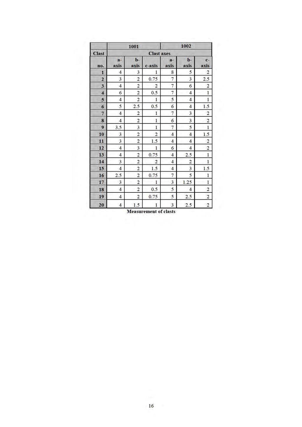
3 CONWY VALLEY FLOOD ALLEVIATION SCHEME LLANRWST DEMOUNTABLE TRENCHES 1-3 ARCHAEOLOGICAL EXCAVATION (G1877) Gwynedd Archaeological Trust Report No. 873 CONTENTS Page Summary 3 1. Introduction 3 2. Specification and Project Design 3 3. Methods and Techniques 3 4. Archaeological Background 4 5. Results of the Excavation 5 6. Summary and Conclusions 7 7. Site Archive 8 8. References 8 Appendix 1 Appendix 2 Contexts Summary Mortar Sample Report; Llanrwst Bridge parapet by Martin Locock BA MIFA and Jenny Hall BSc MIFA FIGURES Fig. 1. Location map Fig. 2 1 st edition 25 inch Ordnance Survey map of 1875, Denbighshire sheets XI.13 and XI.14, showing the location of demountable trenches in red Fig. 3 Buckler print of Llanrwst Bridge by John Buckler (NLW Drawing Volume 85) Fig. 4 Tithe Map of Llanrwst, dating to 1839, showing area of demountable trenches (DRO TM/73/7) Fig. 5 Location of demountables 1-3 overlain on Mostyn estate maps of the 1770s (Mostyn MSS S8535) Fig. 6 Demountable Trenches overlain on Mostyn MSS 8534 The Market Town of Llanrwst, Denbighshire. Area of town discussed in text outlined in red Fig. 7 Demountable Trench 1, Western end Fig. 8 Trench 3, Demountable 2 Cobbled road surface Fig. 9 Plan of Demountable 1, Trench 2 Fig. 10 South East Facing Section through Demountable 1, Trench 2 1
4 PLATES Plate 1 Llanrwst Bridge from the west, showing area of Demountable 1 on the east bank of the river Conwy above 1794 parapet. Plate 2 The 1636 Bridge parapet (right foreground) and 1794 revetment (background). Scale 1m Plate 3 Revetment wall (1001), and parapet (1002) from the east. Scale 1m Plate 4 Detail showing smooth face of 1636 parapet wall Plate 5 View looking west showing capstones for the culvert (031). Scale 2m with 50cm divisions Plate 6 The culvert walling (033) with capstone (031) removed. Scale 1m Plate 7 The cobbled surface (022), below make-up layer (021) in Demountable 2 looking south. Scales 2m with 50cm divisions. Plate 8 View from the north of the cobbled surface with cross trenches excavated. Scales 2m with 50cm divisions and 1m Plate 9 View from the south showing infilled cellar to Llewelyn s Accountants. Scale 50cm with 10cm divisions 2
5 CONWY VALLEY FLOOD ALLEVIATION SCHEME LLANRWST DEMOUNTABLE TRENCHES 1-3 ARCHAEOLOGICAL EXCAVATION (G1877) Summary Gwynedd Archaeological Trust has carried out an excavation within the flood plain of the Conwy Valley in the town of Llanrwst in connection with ground works that formed part of the Dyffryn Conwy Flood Allieviation Scheme, on behalf of the Environment Agency. This also forms part of wider archaeological work associated with the scheme, carried out on both banks of the river Conwy. Three trenches were examined. In demountable trench 1, surviving fragments of the17th century bridge parapet was observed. This had been truncated by the building of a river side embankment to protect the town in The pre 1794 road surface were observed in the deposits, buried by later make-up layers, which had the effect of raising the ground surface up to that of the current A470. Evidence for a drainage culvert was noted, which has been shown to date from 1794, was observed. In demountable trench 2 a cobbled surface was observed, which probably formed part of the same pre 1794 road surface seen in trench 1. On the south side of Conwy Terrace, only disturbed ground associated with modern services and a motor garage was observed. This area was open fields until well into the 19 th century. 1. INTRODUCTION Gwynedd Archaeological Trust (GAT) has been asked by The Environment Agency to undertake an archaeological excavation within the town of Llanrwst as a part of the Dyffryn Conwy Flood Alleviation Scheme. This took place during the excavation of foundation trenches for the stanchions for demountable flood barriers at the junction of Bridge Street with the A470 close to the Bont Fawr (NGR SH ), Llanrwst, and also to the south on either side of the junction of the A470 with Conwy Terrace (Fig. 1, centred on SH ). This formed part of a wider scheme of archaeological work associated with the Dyffryn Conwy Valley Flood Alleviation Scheme (Davidson 2005), test pitting (Roberts 2006) and including work on the Trefriw Borrow Pit area (Kenney 2009; Evans 2010). 1.1 Acknowledgements The assistance of Ashley Batten of Gwynedd Archaeological Planning Service (GAPS) and Ed Wilson, Environment Agency Archaeologist, is gratefully acknowledged. The assistance of the staff of the contractors, May Gurney who provided the plant for the excavation and carried out much of the excavating work is gratefully acknowledged. 2. SPECIFICATION AND PROJECT DESIGN There was no specific brief for this work. The work undertaken followed a previously agreed project design and conforms to the guidelines specified in Standard and Guidance for Archaeological Excavation (Institute of Field Archaeologists, 1994, rev. 2001). The work was monitored by the Environment Agency, with recommendations given by the Senior Archaeologist, National Environmental Assessment Service (West Team), along with Ashley Batten of Gwynedd Archaeological Planning Service (GAPS). 3. METHODS AND TECHNIQUES 3.1 Introduction The excavations within the demountable trenches in Llanrwst were carried out in conjunction with the ground works for the foundations of the demountable trenches, and were carried out in various stages to fit in with this work. This involved the excavation of the western half of demountable 1 trench in June 2009 (Trench 1), which consisted of an area 6.5m long by 2.46m wide, which was excavated to a 3
6 depth of 1.1m. This section of the trench contained the remnants of the bridge parapet. In July 2009 the eastern half of the demountable 1 trench was excavated, which involved work by two archaeologists. In late July 2009work began on the trenches for demountable 2 (Trench 3). The commenced around the north west corner of Conwy Terrace at its junction with the A470, adjacent to T. Llewellyn Hughes Solicitors, and was dug to a depth of 1.55m. This work continued until August Work Method Excavation Three demountable trenches were excavated on the eastern bank of the Afon Conwy. Demountable 1 was located across the A470 road, known at this point as Trem yr Orsedd, immediately east of the Pont Fawr, Llanrwst and close to its junction with Bridge Street (Fig. 1). Demoutables 2 and 3 were located about 70m south of Demountable 1, orientated north-west south-east along Trem yr Orsedd on the road pavement either side and across Conwy Terrace. Most of the excavation work was carried out by the contractors, May Gurney, although significant archaeological contexts were cleaned, drawn and photographed by the archaeological team. The excavation areas were cleaned by hand tools onto the archaeological deposits and planned in relation to the whole site and scale plans at a scale of 1:20 were drawn. Sections across relevant features were drawn at a scale of 1:10, and a photographic record was maintained. Each distinct layer or evidence of archaeological activity was given its own unique context number and a descriptive record made, and these are referred to throughout the discussion of the results below in brackets. Their relationships to each other were shown on the scale drawings and a photographic record was maintained. The locations of the deposits were surveyed and related to the nearest Ordnance Survey bench mark Reporting and archiving This report describes the results of the evaluation and presents a description and interpretation of features and deposits recorded. A full list of contexts and their descriptions, including the earthworks, is given in appendix I. 4. HISTORICAL AND ARCHAEOLOGICAL BACKGROUND The town of Llanrwst owes its location to being the first place where the Afon Conwy could be crossed by means of a ford, which would have encouraged early settlement, and had probably encouraged the foundation of St. Grwst s church on the eastern the river bank. The river formed the boundary between the post Edwardian conquest counties of Denbighshire and Caernarfonshire, Llanrwst being located on the Denbighsire side. The town is referred to in the Norwich taxation of 1254 and the Lincoln taxation of 1291, and reference to a market is first recorded in By the 14 th century there was a borough on the site, but there is no record of its foundation, and the majority of the burgesses were Welsh (Soulsby 1983, 172). Glyndwr s attack on the town in 1401 brought such a desolacion that greene grasse grewe on the market place and the deare fed in the churchyard (Ballinger 1927, 52-53). The parish church appears to have been rebuilt in early Tudor times, as the town recovered after the Glyndwr uprising. By the early 17 th century Llanrwst was beginning to recover its position in the locality, and had a flourishing market. Construction of Llanrwst Bridge (Bont Fawr) began in 1636, and was a vital link for the Wynns of Gwydir, linking their estate with disparate portions of it at Cae r Melwyr and Berth Ddu (Tucker 2002, 20). The bridge has three cutwaters, which are extended to coping level where they form refuges for pedestrians, and stone panels rise over the apex of the central arch. The south panel bears the Stuart Royal arms and is dated The west arch of the bridge collapsed in 1675, possibly weakened by damage to it sustained during the civil war, and emergency repairs were carried out (Gwynedd Archives, Caernarfon, Quarter Sessions Papers). Further repair work was carried out in 1703, when the western arch of the bridge gained its current appearance (Bingley 1814, 302). The road, later turnpiked, into the town from the south (Mostyn MSS 8534; Mostyn MSS S8535; Figs. 4 and 5) had a metalled cobbled surface in the 18 th century, and rose steeply as it approached the Bridge, and Bridge Street leading into the town, which is shown on the late 18 th century print (Fig. 3). 4
7 In 1793 it was decreed that the present walls along the river being out of repair [are] to be taken down and rebuilt from a mark in the of the Bridge in a line to the west corner of the present turnpike house. To have the bottom of the walls set in..and flushed with hot mortar to the level of the road, four feet thick at the bottom, to batter from the river one inch to the foot and to be three feet thick at the level of the road and one foot six inches thick above the road at least three feet six inches high including the coping which is to be of the best stone from Trefriw, not less than three feet six inches in length worked to the thickness of the battlement The whole road to be raised on an average two feet six inches high to the south gable of the house in Llanrwst called Ty Mawr, and the other way past the Turnpike Gate to a barn belonging to Miss Hughes. The road along the cottages that face the bridge, a wall of strong stones to be built a convenient distance from the houses to the level of the road, and a good post and double rail of Oak along the said property plained and painted. A good flagged path before these houses and a stone drain to be made across the street at a place to be fixed of a proper size to take away the water The floor of the large bridge [Bont Fawr] to be effectually repaired as likewise the battlements. The whole of the roads to have a top covering of Chestry gravel from a place called Bryn Rhydd near Maynan, ten inches thick in the middle and seven inches on each side seven yards wide. Where the foundations of the walls cannot be laid on the rock they must be laid two feet below the bed of the river with large flat stones (DRO QSD/AB/1/425(a)). This agreement of repairs details much of the 18 th century construction worked noted within the demountable trenches. The Almshouses in Llanrwst, along with the free school, were built in c under the patronage of Sir John Wynn of Gwydir Castle and comprised twelve rooms designed to house the elderly poor, one to each room. The lodging was provided for free with a small stipend supplied to each tenant. The east ground floor apartment was reduced to a passageway in 1812 to give access to Tan-y-Fynwent, behind the Almshouse. In 1843 women were admitted, whilst improvements were made to the premises in the mid-nineteenth century, including the construction of twelve coal houses and a ladies toilet, which were built in the yard and new furniture was placed in the rooms. The Almshouse was renamed the Hospital of John Wynn of Gwydir in 1927 and continued in its use as a home for the elderly until its closure in The Almshouse was restored in the late 1990 s and opened as a community museum and visitor attraction in The school was built to the east of the town. The town was further improved in 1661 when a town hall was built in the spacious market square. This building was demolished in Pennant (1782) describes the town of Llanrwst as small and ill built, and has nothing remarkable except the church (Pennant 1783, 152), although the almshouses and free school were well established in the town by then. Bingley (1814) describes the town as having nothing to recommend it to notice: the streets are narrow, and the houses very irregular (Bingley 1814, 303). During the 18 th and 19 th centuries, as well as being the main market town for a wide hinterland in both Denbighshire and Caernarfonshire, Llanrwst became a centre of watch and clock making, of which many examples survive. Bingley (1814) describes the Eagles Inn as being the only one where post horses are kept, [and] in general found a very comfortable house; but during the summer season it is often so much crowded by company as to render it very unpleasant to the wearied tourist (Bingley 1814, 305). The arrival of the railway at the town in 1863 encouraged further development in the town (Fig. 2). 5. RESULTS OF THE EXCAVATION 5.1 Description Trench 1 (Demountable 1, west end) The excavation at the western end of the Demountable 1 trench (Fig.7) was dug by the contractors to a depth of 1.1m below the modern macadamised road surface. The removed deposits consisting of road surfaces and backfill associated with service trenches (1008). A metalled surface was noted 2.2m east of the revetment wall, which was 2.1m wide. It was constructed of irregular sub-angular stones up to 0.25m across (1007). The surface was 0.1m higher at the north end than at the south. Possible groves worn and depressed into the surface were noted, possibly caused by carts pulling up the hill towards the Bont Fawr. This overlies an extensive sub-base material of dark orangy brown silty clay, which is probably a levelling layer for the road (1006). This overlay greyish brown silty clay (1005) 5
8 A mid reddish brown sandy clay silt overlay the stones belonging to the foundations of the revetment wall [1001] (Plate 3), which was built in 1794 (DRO QSD/AB/1/425(a). This was shown to overlie a stub of the bridge parapet of the Bont Fawr, dating from 1636 [1002] (Plates 2-4). This consisted of coursed rubble masonry, with blocks up to 0.8m square, and observed to a depth of 0.21m. Mortar samples from these two deposits have been analysed, and the results of this are shown in Appendix Mortar Report (Appendix 2) The mortar from the 1794 revetment wall (1001) and the 1636 Bridge parapet were sampled and analysed. The mortars were found to have similar composition, probably reflecting an informal formula of one part lime to two parts gravel and sand. The later mortar (1002) contained a significant quantity of bulking agents such as coal, ash and charcoal, which only became commonplace in the later part of the 18 th century, but became an established part of the building tradition of the time Trench 2 (Demountable 1, east end) At the eastern end of the Demountable 1 trench (Fig.9) a hard road sub surface (004) overlay a mid orangey brown silty clay make-up layer (005). Cut into this deposit were a number of modern service trenches (006, 007), including a British Telecom service trench [009] with its fill (008). Layer (005) overlies a deposit of stones, on a north-west south-east alignment. This consisted of sub angular stones, up to 0.8m by 0.4m in size, making up the foundation core of a wall [010]. It appeared to lie directly on the probable alluvial deposit (030), and appears to be associated with the probable floor surface (014) which butts up against it, and runs parallel with a culvert [032], approximately 1m to the north east. There was infill material (011) within it, consisting of a mid greyish brown silty clay with gravel. A make-up layer (013=005), surviving to a depth of 0.44m, of a mid orangey brown silty clay which overlay the possible floor surface, is probably the same deposit as (005). The area of possible floor surface 0.8m by 0.26m, was apparently constructed at the same time as the culvert [032], as it overlies the south west wall lining, but is then partly covered with capstones [031] (Plate 6). Wall [010] overlay and culvert [032] cut into a stony demolition layer (042) (Fig. 10). This overlay a mid grey clayey sand, 0.35m deep (030). This is probably an alluvial silt, which overlies a stony make up layer (029) of sandy gravel. This overlies 0.35m of dark brownish grey gravel (046), which was probably an alluvial deposit, overlying a mid orangey-brown silty sand natural subsoil (045) Trench 3 (Demountable 2) Below a grey gravel sub surface (002), a make-up deposit, 0.6m thick, a dark orangey brown silty clay with medium rounded and sub angular stones (021), which had been removed by the contractors overlay a cobbled floor surface (022), made of rounded stones up to 0.4m across (Fig. 8; Plates 7-8). The extent of the cobbled surface was difficult to determine as it extended over the full open area of the trench, however it was cut by the construction cut of the building to the east, currently a solicitor s office. The cobbled surface was laid on a bed of sand (039) on a make-up layer of dark brownish grey silty clay (040), 0.68m deep, with small to large rounded and sub angular stones. This overlay mid orangy brown silty clay, probably caused by alluvial silting, which is of unknown depth (041). It is likely that this was caused by periodic flooding of the Afon Conwy. The trench was cut by a number of patches of later disturbance [024], filled with (025) and (026), and [027], filled by (028). At the eastern end of the trench, as it turned eastwards along Conwy Terrace, the ground was entirely disturbed as a result of the digging of the foundations and cellar of the current accountants building (Plate 9) Trench 4 (Demountable 3) The area of pavement to the south of Conwy Terrace consisted entirely of disturbed ground and service trenches, and make up layers. These overlay a mid orangy brown silty clay, which was noted at a depth of 1.1m. 5.2 Finds 6
9 The only material that was recovered from the demountable trenches was modern material associated with service trenches, which was not retained Interpretation Demountable 1 (Figs. 6, 8 and 9) The road surface noted 1.1m below the ground surface in trench 1 is probably the road that pre-dates the raising of the embankment by the building of the retaining wall in 1794 (DRO QSD/AB/1/425(a)). The presence of grooves marked by cart wheels in the metalled surface of the road can probably be explained by the friction caused by carts needing to pull up the relatively steep incline towards the Bont Fawr. This incline was lessened after the raising of the ground surface with a substantial make up layer (021), behind a revetment wall 1.9m high. This activity, carried out in 1794 involved the truncation of the 17 th century bridge parapet (1001), and the construction of a revetment wall (1002), and subsequent make up and road sub surface layers. The eastern end of the Demountable 1 trench contained a large stone lined culvert [032] cut into the natural sub soils (045), overlaid with capping stones and an adjacent floor surface. This is clearly earlier than the make up layer (005) and subsequent road surfaces and service trenches, and is cut into a demolition layer (042). This demolition layer is probably associated with the construction of the revetment wall, and suggests that the stone-lined culvert post-dates, or is contemporary with, the raising of the ground surface in 1794, as suggested by the documentary evidence (ibid.). Demountables 2 and 3(Fig. 7) A cobbled road surface (022) was noted below a substantial make-up layer (021). This is likely to be the same road surface seen in the demountable 1 trench, and shown on the mid 18 th century estate map (Fig. 3). To the south in demountable 3 the area was open fields until into the 20 th century (Fig. 4) and no archaeological deposits were encountered. This overlay a deep make-up clay deposit where the bottom of the deposit was not seen (041). This would appear to have been created by a long period of alluvial silting, as suggests that prior to the construction of the road the river was wider at this southern part of the town. The lack of other archaeological features in trench 4 (Demountable 3) can be explained by the fact that the area was an open field, as shown on figs. 5 and 6, and there is no evidence for development in this area until the garage and other services arrived in the mid 20 th century. 6. DISCUSSION AND CONCLUSIONS The identification of the parapet of the 1636 Bont Fawr indicates that there has been significant survival of the original angled bridged parapet, which is shown on the Buckler print (Fig. 3), and many other late 18 th century images. Archaeological evidence for the raising of the river bank and the revetment wall in 1794 was also evidenced. The archaeological evidence uncovered along the banks of the Afon Conwy in Llanrwst demonstrates that significant evidence for the cobbled road from the south on the east bank of the river, shown on the 18 th century estate map, surviving below the raising of the embankment after Some evidence for drainage from the town, in the form of stone lined culverts, was also encountered, and these are thought to date from a similar time to the building of the revetment wall. Significant evidence for alluvial silting predating the road was also encountered, suggesting that the river was wider in medieval and earlier times south of the Bont Fawr. The analysis of the mortar revealed distinct characteristics in the two mortar samples, particularly with the late 18 th century characteristics in the mortar associated with the revetment wall. 7
10 7. SITE ARCHIVE The site archive consists of 47 context sheets, five A2 sheets containing, plans of the site drawn at a scale of 1:20 and six sections drawn at a scale of 1:10, and 83 digital images. They are currently held by GAT under project code G1877. Three copies of the bound report will be sent to Ed Wilson at the Environment Agency, a copy to Ashley Batten at GAPS, and a further copy sent to the HER Archaeologist at the curatorial division of Gwynedd Archaeological Trust, Bangor, for deposition in the Regional HER. A copy of the report will be provided to the National Monument Record, Royal Commission on the Ancient and Historic Monuments of Wales, Aberystwyth. 8. SOURCES CONSULTED 8.1 Primary Sources Denbighshire Record Office, Rhuthin Agreement and Repairs for Llanrwst Bridge 1793 (QSD/AB/1/425(a) Tithe map for the parish of Llanrwst 1839 (TM/73/7) Ordnance Survey County Series Caernarvonshire Sheet XIV.13, First edition 1889 University Archives, Bangor Mostyn MSS 8534 c.1834 The Market Town of Llanrwst, Denbighshire Mostyn MSS S8535 c.1770 Map of Properties in the Town of Llanrwst Mostyn MSS 8536 Berth Du Estate. Map of the Houses and Premises in the Town of Llanrwst 7.2 Secondary Sources Ballinger, J History of the Gwydir Family (Cardiff) Berks, T Dyffryn Conwy Flood Alleviation Scheme: Archaeological Watching brief (GAT Report 696) Bingley, Rev. W 1814 North Wales Davidson, A Dyffryn Conwy Flood Alleviation Scheme: Archaeological Assessment (GAT Report 618) Evans, R.T.J Trefriw Borrow Pit. Archaeological Excavation (GAT Report No. 864) IFA Institute of Field Archaeologists 2001 Standard and Guidance for an archaeological excavation. Jones, E. G., 1952 (ed.) A description of Caernarvonshire by E. Hyde Hall. Kenney, J Conwy Valley Flood Alleviation Scheme: Trefriw Borrow Pit. Report on an Archaeological Evaluation (unpublished GAT Report No. 784) Lewis, E.A. 1912, The Medieval Boroughs of Snowdonia. Pennant, T., 1783 A Tour in Wales
11 Roberts, J Dyffryn Conwy Flood Alleviation Scheme: Archaeological Watching Brief (GAT Report 622) Soulsby, I The Towns of Medieval Wales (Chichester) Tucker, N Llanrwst: The History of a Market Town (Ashbourne) 9
12
13

14 Fig. 3 Print of Llanrwst Bridge by John Buckler (NLW Drawing Volume 85)

15 Fig. 4 Tithe Map of Llanrwst, dating to 1839, showing area of demountable trenches (DRO TM/73/7)

16 1 2 3 Fig. 5 Location of demountables 1-3 overlain on Mostyn estate maps of the 1770s (Mostyn MSS S8535)

17 Fig. 6 Demountable Trenches overlain on Mostyn MSS 8534 The Market Town of Llanrwst, Denbighshire. Area of town discussed in text outlined in red
18
19
20
21
22 APPENDIX 1 Context List Trench 001 Macadamised Road Surface 2 and Light grey gravel upper fill 2 and Dark grey gravel lower fill Firm road sub surface Mid orangy brown silty clay make-up layer Cut of metal pipe trench Cut of PVC pipe trench Mid greyish brown fill of BT trench Cut of BT trench Wall structure Mid greyish brown fill within wall VOID 013 Mid orangy brown deposit to N of wall Possible floor surface below (13) Fill of [06] Mid orangy brown silty clay Upper fill of [09] Second fill of [09] Concrete fill of [07] Lower fill of [07] Make up layer below (02) Cobbled floor surface Disturbed ground at east end of trench Patch of disturbed ground Fill of [23] Fill of [24] Cut of disturbed patch Fill of [27] Stony make-up layer Clay/sand deposit Capstones for culvert Cut of culvert NE wall of culvert [032] SW wall of culvert [032] Row of cobbles, holding [031] in place Cut of possible post hole/void in wall [010] NE-SW Lateral connecting culvert Silty deposit in the base of [032] Sandy infill of cobbles [22] Make-up of silty clay below (23) Mid orangy clay silt Stony demolition layer Thin clayey deposit Sandy deposit Natural subsoil Alluvial gravel above natural Alluvial clay/sand deposit 2 10
23 APPENDIX 2 MORTAR SAMPLE REPORT Llanrwst Bridge parapet Mortar By Martin Locock BA MIFA and Jenny Hall BSc MIFA 1 Introduction Two samples of mortar were recovered from archaeological mitigation works on the structure of Pont Fawr (Llanrwst Bridge), Llanrwst, Conwy, and submitted for analysis. Sample 1001 was derived from a rebuilding of the bridge parapet, and 1002 from the original parapet. An initial report was prepared based on physical appearance; quantitative analysis and characterisation was then undertaken. 2 Methodology The samples were crushed and coarse aggregate larger than 2mm were removed. A subsample of the remainder was then dissolved in dilute hydrochloric acid as recommended by (Cadw 2004, 2), dried and weighed to establish the lime content. The aggregate was then examined visually and characterised by size and shape using the Wentworth scale and roundness as defined by Powers (1953). Twenty grains from each sample were then characterised by sphericity and the length, width and depth analysed using Tri-Plot developed by Graham and Midgley (2000) and classified according to Sneed & Folk (1958). The results were tabulated and tri-plotted using Overall composition of the mortar was calculated from the coarse and fine aggregate and soluble (lime) components. 11
24 3 Catalogue of samples Context Description Date 1001 Hard grey-brown mortar with lime lumps Late 18 th century 1002 Moderately hard pale brown mortar Pre 18 th century 4 Component analysis Both mortars were non-uniform in material, and contained coarse aggregate of diverse size and shape. These large stones were therefore removed from the samples after crushing. Sample Coarse aggregate (g) Fine aggregate and lime (g) Total (g) A subsample was then extracted from the remaining fine components. Sample Fine aggregate (g) Lime (g) Total subsample (g) %lime
25 5 Assessment of size and roundness of individual grains Wentworth Scale Pebble (4mm-64mm) Gravel (2mm-4mm) Very Coarse Sand (1.00mm- 2.00mm) Coarse Sand (0.5mm 1.00mm) Medium sand (0.25mm 0.50mm) Fine sand (0.125mm 0.25mm) Very fine sand (0.125mm mm) Coarse Silt (0.0625mm mm) Clay (less than mm) Sample 1001 Sample 1002 % by Roundness Description % by Roundness visual visual assessment assessment <5% 10% 10% 10% <1 % quartz Remainder Indeterminate dark grey., grey and grey/brown rock 20% 20% 10% Subrounded 10% Not 10% Assessed 5% 10% 5% 15% 5% 15% 5% 15% 10% Subrounded Subrounded Subrounded Subrounded Subrounded Subrounded Subrounded Not assessed Description <5%, Black, vesicular material, light in weight; <1% quartz; Remainder Indeterminate grey and grey/brown rock 13
26
27
28
29
30 9 References Cadw 2004 The use of lime mortar in historic structures (Technical Conservation Note 2) (Cadw, Cardiff). Graham, D J, and Midgley, N G 2000 Graphical representation of particle shape using triangular diagrams: an Excel spreadsheet method. Earth Surface Processes and Landforms 25 (13): Locock, M 2010 Bricks and mortar: post-medieval buildings archaeology in Wales. The Archaeologist 75: 37. Peate, I C 1946 The Welsh House: A study in folk culture (Brython Press, Liverpool). Powers, R C 1953 A new roundness scale for sedimentary particles. Journal of Sedimentary Research; June 1953; 23 (2): Sneed, E D, and Folk, R L 1958 Pebbles in the lower Colorado River, Texas: a study of particle morphogenesis. Journal of Geology 66 (2):
31 YMDDIRIEDOLAETH ARCHAEOLEGOL GWYNEDD GWYNEDD ARCHAEOLOGICAL TRUST Craig Beuno, Ffordd y Garth, Bangor, Gwynedd. LL57 2RT Ffon: Ffacs: gat@heneb.co.uk
ROUKEN GLEN: BANDSTAND 2015 DATA STRUCTURE REPORT
 ROUKEN GLEN: BANDSTAND 2015 DATA STRUCTURE REPORT Author (s) Ian Hill Editors Report Date June 2015 Working Partners Funders Phil Richardson East Renfrewshire Council East Renfrewshire Council, Heritage
Afon Adda Refurbishment Bangor
 Afon Adda Refurbishment Bangor Archaeological Assessment Revised Report GAT Project No. 1876 Report No. 628 April 2006 Ymddiriedolaeth Archaeolegol Gwynedd Gwynedd Archaeological Trust Craig Beuno, Ffordd
Archaeological Evaluation Report
 Holywell House Osney Mead Oxford o a November 2007 Client: Knowles and Son Issue N o : 1 OA Job N o : 3826 Planning Ref N o : 02/01800/FUL NGR: SP 502 055 Client Name: Knowles and Son Client Ref No: Document
Archaeological Monitoring at Ham Farm, Ham Road, Faversham, Kent
 Archaeological Monitoring at Ham Farm, Ham Road, Faversham, Kent NGR: 601750.0mE 162695.0mN Site Code HAM/WB/12 Report for A.J. Bray SWAT ARCHAEOLOGY Swale and Thames Archaeological Survey Company The
A487 PONT SEIONT ARCHAEOLOGICAL RECORDING REPORT NO Y mddiriedolaeth Archaeolegol Gwynedd Gwynedd Archaeological Trust
 A487 PONT SEIONT ARCHAEOLOGICAL RECORDING REPORT NO. 148 Y mddiriedolaeth Archaeolegol Gwynedd Gwynedd Archaeological Trust A487 PONT SEIONT ARCHAEOLOGICAL RECORDING prepared for Welsh Office Highways
Cholesbury New House, Parrots Lane, Cholesbury, Buckinghamshire
 Cholesbury New House, Parrots Lane, Cholesbury, Buckinghamshire An Archaeological Watching Brief For Mr Martin Wood by Sean Wallis Thames Valley Archaeological Services Ltd Site Code PLC 06/135 March 2007
The Coach House, Mill Lane, Cookham, Berkshire
 The Coach House, Mill Lane, Cookham, Berkshire An Archaeological Watching Brief For Ms Sophia Butler by Stephen Hammond Thames Valley Archaeological Services Ltd Site Code CMC 03/104 October 2003 Summary
The Old Shire Horse Centre, Bath Road, Woolley Green, Maidenhead, Berkshire
 The Old Shire Horse Centre, Bath Road, Woolley Green, Maidenhead, Berkshire An Archaeological Watching Brief For Mr Derek Chesterman by Andrew Mundin Thames Valley Archaeological Services Ltd Site Code
Archaeological Watching Brief on land at Alpha, Gore Road, Eastry, Kent July 2010
 Archaeological Watching Brief on land at Alpha, Gore Road, Eastry, Kent July 2010 SWAT. Archaeology Swale and Thames Archaeological Survey Company School Farm Oast, Graveney Road Faversham, Kent ME13 8UP
Excavations in a Medieval Market Town: Mountsorrel, Leicestershire,
 Excavations in a Medieval Market Town: Mountsorrel, Leicestershire, by John Lucas Mountsorrel is situated 12 kms north of Leicester and forms a linear settlement straddling the A6, Leicester to Derby road.
An archaeological watching brief on land adjacent to 50 Rosebery Avenue, Colchester, Essex May/June 2003
 An archaeological watching brief on land adjacent to 50 Rosebery Avenue, Colchester, Essex May/June 2003 report prepared by C Crossan on behalf of Highfield Homes Ltd NGR: TM 0035 2500 CAT project ref.:
Henderson Mess, RAF Halton, Buckinghamshire
 Henderson Mess, RAF Halton, Buckinghamshire An archaeological watching brief for Stepnell Ltd by Stephen Hammond Thames Valley Archaeological Services Ltd Site Code RHA03/85 October 2003 Summary Site name:
Wessex Archaeology. Little Stubbings, West Amesbury, Salisbury, Wiltshire. Archaeological Watching Brief. Ref:
 Wessex Archaeology Little Stubbings, West Amesbury, Salisbury, Wiltshire Ref: 63280.02 March 2007 LITTLE STUBBINGS, WEST AMESBURY, NR SALISBURY, WILTSHIRE ARCHAEOLOGICAL WATCHING BRIEF Prepared for: P
Report on an archaeological watching brief at Thomas Lord Audley School, Monkwick, Colchester
 Report on an archaeological watching brief at Thomas Lord Audley School, Monkwick, Colchester July 2000 for WS Atkins Property Services Colchester Archaeological Trust 12 Lexden Road, Colchester, Essex
Archaeological Watching Brief at the Brick Stables and Wagon Lodge, Abbey Barns, Abbey Road, Faversham, Kent September 2010
 Archaeological Watching Brief at the Brick Stables and Wagon Lodge, Abbey Barns, Abbey Road, Faversham, Kent September 2010 SWAT. Archaeology Swale and Thames Archaeological Survey Company School Farm
BRONZE AGE FIELD SYSTEM AT SOUTHAMPTON AIRPORT
 Proc. Hampshire Field Club Archaeol. Soc. 65, 2010, 1-6 (Hampshire Studies 2010) BRONZE AGE FIELD SYSTEM AT SOUTHAMPTON AIRPORT By J SULIKOWSKA With contributions by LORRAINE MEPHAM and CHRIS J STEVENS
o a London Borough of Barnet Stoney Wood Lake Silk Stream Flood Alleviation Scheme Archaeological Watching Brief Report Oxford Archaeology
 Silk Stream Flood Alleviation Scheme Stoney Wood Lake London Borough of Barnet Archaeological Watching Brief Report o a Oxford Archaeology November 2004 Client: Halcrow on behalf of Environment Agency
S E R V I C E S. Land to the rear of Ashdown, Basingstoke Road, Spencers Wood, Reading, Berkshire. Archaeological Evaluation.
 T H A M E S V A L L E Y ARCHAEOLOGICAL S E R V I C E S Land to the rear of Ashdown, Basingstoke Road, Spencers Wood, Reading, Berkshire Archaeological Evaluation by Susan Porter Site Code: ASW12/21 (SU
Holyport Manor Special School, Highfield Lane, Cox Green, Maidenhead, Berkshire
 Holyport Manor Special School, Highfield Lane, Cox Green, Maidenhead, Berkshire An Archaeological recording action For CgMs Consulting by Jennifer Lowe Thames Valley Archaeological Services Ltd Site Code
An archaeological excavation at 193 High Street, Kelvedon, Essex September 2009
 An archaeological excavation at 193 High Street, Kelvedon, Essex September 2009 report prepared by Ben Holloway and Howard Brooks on behalf of Marden Homes CAT project ref.: 09/4g NGR: TL 8631 1913 (c)
An archaeological evaluation at 19 Beverley Road, Colchester, Essex February 2003
 An archaeological evaluation at 19 Beverley Road, Colchester, Essex February 2003 report prepared by Carl Crossan on behalf of Mr G and Mrs H Prince NGR: TL 98655 24844 CAT project ref.: 03/2d Planning
Gorse Stacks, Bus Interchange Excavations Interim Note-01
 Gorse Stacks, Bus Interchange Excavations 2015 Prepared for: Cheshire West & Chester Council Interim Note-01 1 Introduction & Summary Background Since c. 2000 investigations associated with redevelopment
Wheatlands House, Fleet Hill, Finchampstead, Berkshire
 Wheatlands House, Fleet Hill, Finchampstead, Berkshire An Archaeological Watching Brief For JCA International by James McNicoll-Norbury Thames Valley Archaeological Services Ltd Site Code WFF 08/26 August
Revision: Date: Prepared by: Checked by: Approved by: Reason for Issue: Nick Elsden (MOLA) Nick Elsden (MOLA) Page 2
 Nick Elsden (MOLA) Page 2") This document contains proprietary information. No part of this document may be reproduced without prior written consent from the chief executive of Crossrail Ltd. Revision: Date: Prepared by: Checked
This document contains proprietary information. No part of this document may be reproduced without prior written consent from the chief executive of Crossrail Ltd. Revision: Date: Prepared by: Checked
East Midlands Region LEICESTER 3/16 (E.62.A010) SK
 SK") LEICESTER City of Leicester 3/16 (E.62.A010) SK 5853 0433 12 NEW ST., CASTLE WARD, LEICESTER Cottage to the Rear of 12 New St., Castle Ward, Leicester - A Photographic Survey and Archaeological Watching
LEICESTER City of Leicester 3/16 (E.62.A010) SK 5853 0433 12 NEW ST., CASTLE WARD, LEICESTER Cottage to the Rear of 12 New St., Castle Ward, Leicester - A Photographic Survey and Archaeological Watching
archaeological evaluation of sites to the west of the castle in 1988
 FLNT CASTLE archaeological evaluation of sites to the west of the castle in 1988 -.., - w -... " - Clwyd-Powys Archaeological Trust '.. - Flint Castle, Delyn: evaluation of sites west of the castle in
Newbold Hall, Rochdale. An Archaeological Excavation
 School of the Built Environment CUBE Building, University of Salford 113-115 Portland Street Manchester M1 6DW Tel: 0161 295 3818 Email: m.d.nevelle@salford.ac.uk Web: www.cfaa.co.uk Newbold Hall, Rochdale.
AFON ADDA REFURBISHMENT DEANERY CAR PARK, BANGOR ARCHAEOLOGICAL EVALUATION
 AFON ADDA REFURBISHMENT DEANERY CAR PARK, BANGOR ARCHAEOLOGICAL EVALUATION GAT Project no. G1876 Report No. 669 Prepared for the Environment Agency March 2007 By G..H. Smith and R.E. Evans AFON ADDA REFURBISHMENT
An archaeological excavation and watching brief at the Musket Club, Homefield Road, Colchester, Essex December 2004-February 2005
 An archaeological excavation and watching brief at the Musket Club, Homefield Road, Colchester, Essex December 2004-February 2005 report prepared by Howard Brooks on behalf of RMPA and the MoD CAT project
An archaeological watching brief at 97 High Street, Colchester, Essex March 2010
 An archaeological watching brief at 97 High Street, Colchester, Essex March 2010 report prepared by Donald Shimmin on behalf of Flying Trade Group plc CAT project ref.: 10/3a Colchester and Ipswich Museums
An archaeological watching brief at the Sixth Form College, North Hill, Colchester, Essex
 An archaeological watching brief at the Sixth Form College, North Hill, Colchester, Essex July 2001 on behalf of Colchester Borough Council CAT project ref.: 01/7B Colchester Museum accession code: 2001.126
Archaeological Observation at The Bishop s Palace, Alvechurch, Worcestershire
 Warwickshire County Council THE MOAT HOUSE Archaeological Observation at The Bishop s Palace, Alvechurch, Worcestershire Chris Jones and Bryn Gethin Report 1059 December 2010 The Moat House: Archaeological
Draft Report. 7. Excavations in the temenos gateway, Area (TG5) Author - D. A. Welsby Period 1-2. Period 1. Period 2. Derek A.
 Author - D. A. Welsby Period 1-2. Period 1. Period 2. Derek A.") 7. Excavations in the temenos gateway, Area (TG5) Derek A. Welsby When Griffith excavated the temples at Kawa in 1929-31, work followed by that of Macadam and Kirwan in the winter of 1935-6, the temenos
7. Excavations in the temenos gateway, Area (TG5) Derek A. Welsby When Griffith excavated the temples at Kawa in 1929-31, work followed by that of Macadam and Kirwan in the winter of 1935-6, the temenos
29 Plas Derwen. Exploring Abergavenny
 29 Plas Derwen Exploring Abergavenny Cover: rhythm 2 plas derwen EXPLORING ABERGAVENNY For several years the Abergavenny and District Civic Society has been studying the streets, spaces and buildings of
Land off Birdie Way, Rush Green, Hertford, Hertfordshire
 Land off Birdie Way, Rush Green, Hertford, Hertfordshire An Archaeological Evaluation for Bride Hall Development Limited by Sarah Coles Thames Valley Archaeological Services Site Code RGH00/ 01 January
4. Bronze Age Ballybrowney, County Cork Eamonn Cotter
 4. Bronze Age Ballybrowney, County Cork Eamonn Cotter Illus. 1 Location map of the excavated features at Ballybrowney Lower (Archaeological Consultancy Services Ltd, based on the Ordnance Survey Ireland
Northamptonshire Archaeology
 Northamptonshire Archaeology A programme of archaeological observation, investigation and recording at St Andrews Church, Spratton, Northamptonshire Northamptonshire Archaeology 2 Bolton House Wootton
Archaeological Investigations Project Yorkshire & Humberside Region NORTH YORKSHIRE 2/1113 (C.36.J002) SD
 SD") NORTH YORKSHIRE Craven 2/1113 (C.36.J002) SD 93607800 CRAY BECK, BUCKDEN, UPPER WHARFEDALE Cray Beck, The Archaeological Investigation of a Stone Feature Archetype Wensleydale : ArcheType Archaeological
NORTH YORKSHIRE Craven 2/1113 (C.36.J002) SD 93607800 CRAY BECK, BUCKDEN, UPPER WHARFEDALE Cray Beck, The Archaeological Investigation of a Stone Feature Archetype Wensleydale : ArcheType Archaeological
THE HEUGH LINDISFARNE
 LINDISFARNE COMMUNITY ARCHAEOLOGY THE HEUGH LINDISFARNE Archaeological excavations in June 2017 Invitation to volunteers THE HEUGH, LINDISFARNE, NORTHUMBERLAND: ARCHAEOLOGICAL EXCAVATIONS 2017 INTRODUCTION
HILL-FORTS OF THE INNER TAY ESTUARY PERTH. Phase One PERTH AND KINROSS. Archaeological Survey Report. Oxford Archaeology North.
 HILL-FORTS OF THE INNER TAY ESTUARY PERTH PERTH AND KINROSS Phase One Archaeological Survey Report Oxford Archaeology North September 2012 Issue No: 2012-13/11322 OAN Job No: L10492a NGR: NO 182 153, NO
E&M West Buildings Union Street, Aberdeen, AB10 1GD
 E&M West Buildings 32-38 Union Street, Aberdeen, AB10 1GD 30 November 2011 E&M West Buildings 32-38 Union Street, Aberdeen, AB10 1GD CONTENTS 1 INTRODUCTION 3 2 ARCHAEOLOGICAL BACKGROUND 4 3 THE WATCHING
FOUNDATIONS OF ARCHAEOLOGY A WALK IN VERNDITCH CHASE
 FOUNDATIONS OF ARCHAEOLOGY A WALK IN VERNDITCH CHASE 1. A Tale of two Long Barrows Long barrows were constructed as earthen or drystone mounds with flanking ditches and acted as funerary monuments during
11 Majors Barn. 19 Mill Street Exploring Abergavenny
 11 Majors Barn 19 Mill Street Exploring Abergavenny Cover: Mill Street from Monmouth Road 2 mill street EXPLORING ABERGAVENNY For several years the Abergavenny and District Civic Society has been studying
Aylesbury Masonic Hall, Ripon Street, Aylesbury, Buckinghamshire
 Aylesbury Masonic Hall, Ripon Street, Aylesbury, Buckinghamshire An Archaeological Recording Action for Wakefield Building Services by Andrew Mundin Thames Valley Archaeological Services Ltd Site Code
Remote Sensing into the Study of Ancient Beiting City in North-Western China
 Dingwall, L., S. Exon, V. Gaffney, S. Laflin and M. van Leusen (eds.) 1999. Archaeology in the Age of the Internet. CAA97. Computer Applications and Quantitative Methods in Archaeology. Proceedings of
Archaeological Investigations Project South East Region SOUTHAMPTON 2/842 (C.80.C004) SU
 SU") SOUTHAMPTON City of Southampton 2/842 (C.80.C004) SU 4382 1336 125 BITTERNE ROAD WEST, SOUTHAMPTON Report on the Archaeological Evaluation Excavation at 125 Bitterne Road West, Southampton Russel, A. D
SOUTHAMPTON City of Southampton 2/842 (C.80.C004) SU 4382 1336 125 BITTERNE ROAD WEST, SOUTHAMPTON Report on the Archaeological Evaluation Excavation at 125 Bitterne Road West, Southampton Russel, A. D
Trench 91 revealed that the cobbled court extends further to the north.
 Report on the 2013 Gournia Excavations The 2013 excavations at Gournia were conducted June 17 July 26 under the aegis of the American School of Classical Studies at Athens and the supervision of the KD
Contents. Crossrail Limited RESTRICTED. Summary of LSS85 archive Broadgate Excavations C257-MLA-T1-XTC-C101_WS
 Summary of LSS85 archive Broadgate Excavations Contents 1 Purpose...4 2 Scope...4 3 Definitions...4 4 LSS85 Archive Summary Report...4 5 Summary Data - Burials found in Liverpool Street...5 6 Note from
An archaeological evaluation at 14 Vineyard Street, Colchester, Essex March 2006
 An archaeological evaluation at 14 Vineyard Street, Colchester, Essex March 2006 report prepared by Ben Holloway commissioned by Colchester Borough Council CAT project code: 06/4b Colchester Museums accession
Visual and Sensory Aspect
 Updated All Wales LANDMAP Statistics 2017 Visual and Sensory Aspect Final Report for Natural Resources Wales February 2018 Tel: 029 2043 7841 Email: sw@whiteconsultants.co.uk Web: www.whiteconsultants.co.uk
Gorton Monastery: An Archaeological Evalaution Report. Final. Client: The Monastery of St Francis and Gorton Trust. Technical Report: Adam Thompson
 ARCHAEOLOGY Gorton Monastery: An Archaeological Evalaution Report Final Client: The Monastery of St Francis and Gorton Trust Technical Report: Adam Thompson Report No: 21/2015 Salford Archaeology, CfAA:
Monitoring Report No. 278
 Roe Valley Country Park Hydroelectric Restoration Scheme Roe Valley Country Park Largy townland County Derry AE/14/30 Ruth Logue Site Specific Information Site location: Roe Valley Country Park, 41 Dogleap
IKLAINA ARCHAEOLOGICAL PROJECT 2016 FIELD REPORT Michael B. Cosmopoulos
 IKLAINA ARCHAEOLOGICAL PROJECT 2016 FIELD REPORT Michael B. Cosmopoulos Introduction The overarching objective of the Iklaina project is to test existing hierarchical models of state formation in Greece
Florence House, High Street, Hurley, Berkshire
 Florence House, High Street, Hurley, Berkshire An Archaeological Watching Brief For Mr Michael Waterhouse by Jo Pine Thames Valley Archaeological Services Ltd Site Code FHH04/52 May 2004 Summary Site name:
PONTOP SMITHY DIPTON, COUNTY DURHAM
 PONTOP SMITHY DIPTON, COUNTY DURHAM ~ ARCHAEOLOGICAL EXCAVATION ~ OCTOBER 2016 Prepared for: Land of Oak & Iron Landscape Partnership By: The Archaeological Practice Ltd. Project code: AP 16/43 Stage:
Specification for Grip blocking using Peat Dams
 Technical Guidance Note 1 Specification for Grip blocking using Peat Dams 1. Introduction Moorland drains (grips) have been dug across much of the Yorkshire upland peatlands. Many of these grips have become
ROUKEN GLEN: MANSION HOUSE 2013 DATA STRUCTURE REPORT
 ROUKEN GLEN: MANSION HOUSE 2013 DATA STRUCTURE REPORT Author (s) Editors Report Date May 2014 Working Partners Funders Paul Murtagh Phil Richardson East Renfrewshire Council East Renfrewshire Council,
Portway Farm, Twyford
 Portway Farm, Twyford Buckinghamshire Archaeological Society HISTORIC BUILDING REPORT / April 2011 Including HS2 high-speed rail line Impact Assessment SURVEY AND REPORT: Sue Fox and John Brushe Report
LLANBEDR ACCESS IMPROVEMENTS
 LLANBEDR ACCESS IMPROVEMENTS NON-MOTORISED USER SUPPLEMENTARY REPORT CPF: 5111 Client: Gwynedd Council Document Control Sheet Document Title: Document Author: Project Manager: Project Title: A496 Llanbedr
N18 Ennis Bypass and N85 Western Relief Road. Site AR125, Clareabbey, Co. Clare
 N18 Ennis Bypass and N85 Western Relief Road Site AR125, Clareabbey, Co. Clare Final Archaeological Excavation Report for Clare County Council Licence No: 04E0023 by Graham Hull Job J04/02 (NGR 134366
KP Lasnaya 1 River
 KP 370.2 Lasnaya 1 River The Lasnaya 1 River crossing is protected by Reno mattings and a gabion wall on the north bank (Photo 1). The south bank consists of natural river gravel deposits on top of Reno
I I I I LINDEN TO WOOD FORD SURVEY ITEMS OF HISTORICAL SIGNIFICANCE I I I I I I I I I I I I I
 LNDEN TO WOOD FORD SURVEY TEMS OF HSTORCAL SGNFCANCE ------------------------------------------------------------------------------ --- - CONTENTS OF THE REPORT 1.0 ntroduction to the Report 1.1 Parameters
Long Cairn Divis County Antrim
 Survey Report No. 66 Harry Welsh Long Cairn Divis County Antrim 2 Ulster Archaeological Society 2018 Ulster Archaeological Society c/o School of Natural and Built Environment Queen s University Belfast
Document History continued Revision: Date: Prepared by: Checked by: Approved by: Reason for Issue:
 Document History continued Revision: Date: Prepared by: Checked by: Approved by: Reason for Issue: 1.0 29/10/2013 Gary Evans Andy Shelley Richard Brown For Acceptance Fieldwork Report CRL Ltd, 2014 Fieldwork
3.0 OVERVIEW OF HUECO BOLSON
 3.0 OVERVIEW OF HUECO BOLSON The Hueco Bolson covers about 2,500 square miles, or 1.6 million acres in New Mexico, Texas, and Chihuahua (Figure 3-1). In Texas, the Hueco overlies portions of El Paso and
Manor Farm, Wilcot, Pewsey, Wiltshire
 Manor Farm, Wilcot, Pewsey, Wiltshire An Archaeological Evaluation for Mr W. Madiment by Helen Moore Thames Valley Archaeological Services Ltd Site Code MFP02/78 September 2002 Summary Site name: Manor
Energy from Waste and Recycling Facility Trident Park, Cardiff. Planning History. January 2010 SLR Ref: B
 Energy from Waste and Recycling Facility Trident Park, Cardiff Planning History January 2010 Ref: 402-0036-0306B Viridor Ltd. i 402/0036/00306B CONTENTS 1.0 INTRODUCTION... 1 2.0 GENERAL HISTORY... 3
Street Sweeper Dump Site, RAF Lakenheath ERL 160
 ARCHAEOLOGICAL MONITORING REPORT Street Sweeper Dump Site, RAF Lakenheath ERL 160 A REPORT ON THE ARCHAEOLOGICAL MONITORING, 2006 (Planning app. no. F/2006/0021/GOV) Jo Caruth Field Team Suffolk C.C. Archaeological
Monitoring Report No. 119
 SITE OF THE OMAGH WORKHOUSE AND FEVER HOSPITAL OMAGH COUNTY TYRONE LICENCE NO.: AE/07/29 BRIAN SLOAN 1 Site Specific Information Site Name: Omagh General Hospital Townland: Lisnamallard SMR No. : N/A State
Following the initial soil strip archaeology is sprayed up prior to planning and excavation
 Barton Quarry & Archaeology Over the past half century quarries have been increasingly highlighted as important sources of information for geologists, palaeontologists and archaeologists, both through
Unlocking Our Coastal Heritage Project: Crane Castle Promontory Fort, Illogan, Cornwall
 Unlocking Our Coastal Heritage Project: Crane Castle Promontory Fort, Illogan, Cornwall As part of a wider project funded by the Rural Development Programme for England (RDPE) and administered through
REPORT NUMBER 001 ARCHAEOLOGICAL DOWSING SURVEY BISHOPS SUTTON NEAR ALRESFORD HAMPSHIRE. D P BRYAN BA (Hons) MARCH 2012
 MARCH 2012") REPORT NUMBER 001 ARCHAEOLOGICAL DOWSING SURVEY AT BISHOPS SUTTON NEAR ALRESFORD HAMPSHIRE D P BRYAN BA (Hons) MARCH 2012 1 Table of Contents 1. Introduction 1.1 Project Background Page 2 1.2 Site Location
REPORT NUMBER 001 ARCHAEOLOGICAL DOWSING SURVEY AT BISHOPS SUTTON NEAR ALRESFORD HAMPSHIRE D P BRYAN BA (Hons) MARCH 2012 1 Table of Contents 1. Introduction 1.1 Project Background Page 2 1.2 Site Location
CASTLE OF OLD WICK HISTORIC ENVIRONMENT SCOTLAND STATEMENT OF SIGNIFICANCE. Property in Care(PIC) ID: PIC282 Designations:
 ID: PIC282 Designations:") Property in Care(PIC) ID: PIC282 Designations: Scheduled Monument (SM90065) Taken into State care: 1957 (Guardianship) Last reviewed: 2004 HISTORIC ENVIRONMENT SCOTLAND STATEMENT OF SIGNIFICANCE CASTLE
Property in Care(PIC) ID: PIC282 Designations: Scheduled Monument (SM90065) Taken into State care: 1957 (Guardianship) Last reviewed: 2004 HISTORIC ENVIRONMENT SCOTLAND STATEMENT OF SIGNIFICANCE CASTLE
Pen-y-gaer Roman Vicus, Cwmdu, Powys: Draft Interim Report
 CPAT Report No 1107 Pen-y-gaer Roman Vicus, Cwmdu, Powys: ARCHAEOLOGICAL EXCAVATION THE CLWYD-POWYS ARCHAEOLOGICAL TRUST CPAT Report No 1107 Pen-y-gaer Roman Vicus, Cwmdu, Powys: ARCHAEOLOGICAL EXCAVATION
Looking north from the SW shieling site with Lub na Luachrach in the foreground
 Looking north from the SW shieling site with Lub na Luachrach in the foreground Upper Gleann Goibhre - Shieling sites Two shieling sites in the upper reaches of the Allt Goibhre were visited and recorded
Investigations at Jackdaw Crag Field, Boston Spa, SE , in by Boston Spa Archaeology and Heritage Group
 0 Investigations at Jackdaw Crag Field, Boston Spa, SE 42304632, in 2006-7 by Boston Spa Archaeology and Heritage Group www.bostonspaheritage.co.uk Preface and Summary This report records the results of
NETHER LARGIE FALLEN STANDING STONE
 NETHER LARGIE FALLEN STANDING STONE EXCAVATION REPORT March 2013 Roderick Regan Kilmartin House Museum Argyll, PA31 8RQ Tel: 01546 510 278 museum@kilmartin.org Scottish Charity SC022744 Summary An outlying
An archaeological fieldwalking evaluation at Tile House Farm, Great Horkesley, Essex July-September 2005
 An archaeological fieldwalking evaluation at Tile House Farm, Great Horkesley, Essex commissioned by ADP Chartered Architects on behalf of The Ingleton Properties Ltd and Mersea Homes CAT project code:
Kirkcaldy Sea Wall Improvements. Non-technical Summary. For illustration purposes only to give an indicative representation of the scheme.
 ENVIRONMENTAL STATEMENT Non-technical Summary For illustration purposes only to give an indicative representation of the scheme. Kirkcaldy Sea Wall Improvements Introduction A concrete sea wall fronts
Cultural Resource Management Report Deer Valley 4wd Restoration and Blue Lakes Road Maintenance Project R
 Cultural Resource Management Report R2015-05-03-10005 Undertaking Description: The proposes to perform road maintenance and meadow restoration on the Deer Valley 4wd trail and road maintenance on the Blue
IMTO Italian Mission to Oman University of Pisa 2011B PRELIMINARY REPORT (OCTOBER-DECEMBER 2011)
") IMTO Italian Mission to Oman University of Pisa 2011B PRELIMINARY REPORT (OCTOBER-DECEMBER 2011) The 2011B research campaign took place in the area around Salut from October, 19 th, to December, 16 th.
IMTO Italian Mission to Oman University of Pisa 2011B PRELIMINARY REPORT (OCTOBER-DECEMBER 2011) The 2011B research campaign took place in the area around Salut from October, 19 th, to December, 16 th.
In 2014 excavations at Gournia took place in the area of the palace, on the acropolis, and along the northern edge of the town (Fig. 1).
.") Gournia: 2014 Excavation In 2014 excavations at Gournia took place in the area of the palace, on the acropolis, and along the northern edge of the town (Fig. 1). In Room 18 of the palace, Room A, lined
Gournia: 2014 Excavation In 2014 excavations at Gournia took place in the area of the palace, on the acropolis, and along the northern edge of the town (Fig. 1). In Room 18 of the palace, Room A, lined
Walking in my Fore father's Footsteps
 Walking in my Fore father's Footsteps by Victor T.D. Holliday As part of the introduction to Local Mining History it falls upon me to undertake research that reflects my personal interest in mining history.
Island Bay Foreshore: Archaeological Issues
 Island Bay Foreshore: Archaeological Issues arczoo Ltd, PO Box 14 575, WELLINGTON ph 04 388 5338 email aczoo@paradise.net.nz Prepared for Wellington City Council February 2005 1 Introduction Wellington
Erica Kinias Brown University, Department of the History of Art and Architecture
 Erica Kinias Brown University, Department of the History of Art and Architecture Archaeological Institute of America Jane C. Waldbaum Scholarship Fund Research Outcomes With the generous support from the
Minutes of Trawsgoed Community Council held at Llanfihangel-y-Creuddyn School on Monday 20th February, 2017 at 7.30 p.m.
 601 Minutes of Trawsgoed Community Council held at Llanfihangel-y-Creuddyn School on Monday 20th February, 2017 at 7.30 p.m. Present: Cllr. Sh. Edwards (Chairman) Cllr. T.A.G. Davies Cllr. H.M. Evans Cllr.
A21 TONBRIDGE TO PEMBURY DUALLING. Statement of Case
 A21 TONBRIDGE TO PEMBURY DUALLING Statement of Case In Respect of Applications for the Demolition of Listed Buildings Under the Provisions of the Planning (Listed Buildings and Conservation Areas) Act
IKLAINA ARCHAEOLOGICAL PROJECT 2015 FIELD REPORT Michael B. Cosmopoulos
 IKLAINA ARCHAEOLOGICAL PROJECT 2015 FIELD REPORT Michael B. Cosmopoulos The 2015 season of the Iklaina project took place from June 1 to July 7. The project is conducted under the auspices of the Athens
Monitoring Report No. 227
 City of Derry Airport Longfield More townland Eglinton County Derry AE/10/61 Ruth Logue Site Specific Information Site location: City of Derry Airport, Airport Road, Eglinton, BT47 3GY Townland: Longfield
Survey of Littleton Down
 Survey of Littleton Down 05 November 2014 The Team: John and Jenny Barnard 1) Introduction Littleton Down (Hill Number 2911, Section 42, OS 1:50000 Map 197, OS 1:25000 Map 121, Grid Ref. SU941150) is listed
Montgomery, PowyS: Electricity Supply I
 THE CLWYD-POWYS ARCHAEOLOGICAL TRUST Montgomery, PowyS: Electricity Supply I ARCHAEOLOGICAL EVALUATION CPAT Report No 82 CPAT Report No 82 Montgomery, PowyS: Electricity Supply I ARCHAEOLOGICAL EVALUATION
Runway Roughness Evaluation- Boeing Bump Methodology
 FLIGHT SERVICES Runway Roughness Evaluation- Boeing Bump Methodology Michael Roginski, PE, Principal Engineer Boeing Airport Compatibility Engineering ALACPA XI Seminar, Santiago, Chile September 1-5,
The Yingtianmen Gate-site of the Sui and Tang Eastern Capital in Luoyang City
 Nandajie The Yingtianmen Gate-site of the Sui and Tang Eastern Capital in Luoyang City Tang Luoyang City-site Archaeological Team, Institute of Archaeology, Chinese Academy of Social Sciences Key words:
An Assessment of Lower Boddington
 W An Assessment of Lower Boddington Design and Conservation Team Reviewed Winter 2017 Contents Introduction... 2 Origins and Archaeology... 3 Historic Development... 3 Plan Form... 3 Space and relationship
SWAN CREEK VILLAGE HOMEOWNERS ASSOCIATION. P.O. Box Bountiful, UT
 RV PARK REQUIREMENTS SWAN CREEK VILLAGE HOMEOWNERS ASSOCIATION P.O. Box 1188 Bountiful, UT 84011-118 The following RV Park requirements were voted on and approved by the Swan Creek Village HOA Board of
DD FORM 3009, FEB 2016 REPLACES DA FORM 1247, WHICH IS OBSOLETE. Page 1 of 6 Pages Adobe Professional X
 ROUTE CLASSIFICATION For use of this form, see ATP 3-34.81/MCWP 3-17.4; the proponent agency is TRADOC. SECTION I 1. SERIAL NUMBER 2. TO 3. FOR INFORMATION 4. DATE/TIME GROUP 5. NUMBER OF SHEETS OR ENCLOSURES
Chiselbury Camp hillfort
 Chiselbury Camp hillfort Reasons for Designation Large univallate hillforts are defined as fortified enclosures of varying shape, ranging in size between 1ha and 10ha, located on hilltops and surrounded
FORMER COUNTY OF SOUTH YORKSHIRE
 FORMER COUNTY OF SOUTH YORKSHIRE Barnsley 3/1883 (E.04.6010) SE 36491121 4 CHURCH HILL, ROYSTON 4 Church Hill, Royston, South Yorkshire. Archaeological Watching Brief (Report No. 868) O'Neill, R Leeds
YORKSHIRE GARDENS TRUST
 YORKSHIRE GARDENS TRUST Hambleton District Historic Designed Landscapes Project Aldwark Manor Report by Louise Wickham[July 2017] 1. CORE DATA 1.1 Name of site: Aldwark Manor 1.2 Grid reference: SE 469630
Report on the excavations on the site Novopokrovskoe II in V. Kol'chenko, F. Rott
 Report on the excavations on the site Novopokrovskoe II in 2016 V. Kol'chenko, F. Rott In 2016 the Novopokrovskiy archeological group of the Institute of History and Heritage of the National Academy of