REPORT NUMBER 001 ARCHAEOLOGICAL DOWSING SURVEY BISHOPS SUTTON NEAR ALRESFORD HAMPSHIRE. D P BRYAN BA (Hons) MARCH 2012
|
|
|
- Hannah Melton
- 5 years ago
- Views:
Transcription
 MARCH")
1 REPORT NUMBER 001 ARCHAEOLOGICAL DOWSING SURVEY AT BISHOPS SUTTON NEAR ALRESFORD HAMPSHIRE D P BRYAN BA (Hons) MARCH
2 Table of Contents 1. Introduction 1.1 Project Background Page Site Location Page Aims and Objectives Page Risk Assessment Page 4 2. Methodology 2.1 Summary Page Written Sources Page Photographic Sources Page Survey 3.1 Grid Lay Out Page Dowsing Survey Page Interpretation Page Results 4.1 Drawn Linear Feature Page Conclusions and Recommendation Page Acknowledgements Page 14 Appendix 1 Risk Assessment Page 15 Appendix 2 TurboCad Results Page 16 Appendix 3 Historic Environment Record Page 17 2

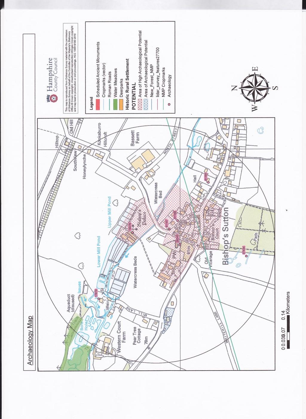
3 1. Introduction 1.1 Project Background The Officers and Committee of HADS decided that there was a need for a formal training session on methods of dowsing, surveying and the recording of underground features. Ideally this training would take place where there were known to be areas of historical and archaeological interest. The location of the site of the Bishop s Palace at Bishops Sutton was known by Don Bryan, Archaeological Director HADS as he had visited the site before. A meeting was arranged by Paul Herbert, Chairman of HADS at which Don Bryan, Paul Herbert and the land-owner Mr Peter Mills discussed the possibility of carrying out an archaeo-dowsing survey of the site of the Bishop s Palace on land behind Sutton Manor. The outcome of this meeting was very positive with permission being granted by Peter Mills to carry out such a survey. 1.2 Site Location The proposed site of survey lay in the meadows to the north of Sutton Manor. Site of Palace OS Copyright
 by using basic archaeology and dowsing techniques.")
4 1.3 Aims and Objectives Areas of survey (Sites 1 & 2) The aim of the weekend research programme was to train members of HADS how to locate the remaining buried walls of the Bishop s Palace (Site One) and a site of possible other structures to the west (Site Two) by using basic archaeology and dowsing techniques. The objectives were to identify buried walls, mark on the surface their shape and dimensions and then record them to scale so that a report could be produced. 1.4 Risk Assessment A risk assessment was written before any research activity was carried out on the site. Every member of the HADS working party was issued with their own copy and this was read by all participants before they were permitted onto the site. A copy of this risk assessment can be found in Appendix 1 of this report. 4
5 2.0. Methodology 2.1. Summary Don Bryan, HADS Archaeological Director, had visited the site many years ago and was shown the area where it was thought that The Bishop s Palace had stood. Before any field work was commenced, a desk based research programme was carried out. Various reports were studied, maps and photographs were examined. It was decided that normal archaeological best practices would be followed in all cases Written Sources The written sources for this site are very limited, in Six New Towns of Bishops of Winchester it states that The first to be considered in detail is New Alresford, seven miles ENE of Winchester, near the junction of the rivers Alre (Arle) and Itchen and less than three miles from the source of the latter. Near the source was the Episcopal Manor of Bishop s Sutton, acquired in 1136 and soon the site of a palace which was a resting place on the London Road and near the wooded hunting country by Alton. The bishop s presence here, together with his household and visitors, was a natural incentive to bring trade outside the palace gate. King John stayed here, and from the king the village obtained a fair and probably its market charter. From British History on Line we have an interesting description of the manor as it was in the time of Edward VI ( ) Sutton is distaunte from Alererford a myle, and the manor howse being a verie old howse, sometime walled around abowte with stone, now decaided, well watered with an olde pond or moote adjoining to it, and the ferme house being sett and within a stones cast of the said manner howse, thowsing being but for a fermer, lying neer to Sutton Cherche. There is a xii score beneth the said manner howse a corn-mille holden be copie, the ponde being the hed dam of the said mill, and a lyttell beneth that a faier great fermhowse belong to the Lorde Chief Justice (Western Court Farm). The very olde howse mentioned by the surveyor was no doubt the Bishop of Winchester s Palace, concerning which Mr Duthy in his Sketches of Hampshire (1839) writes: Within the memory of many persons now living considerable vestiges of a strong and extensive building stood in the meadows to the north of the church, which were the dilapited remains of an ancient palace of the bishops of Winchester. The walls were of great thickness and composed of flints and mortar, but it was impossible to trace the disposition of the apartments or the form of the edifice. He conjectures that it was destroyed in the course of the Civil War. This conjecture seems a plausible one, for many skirmishes must have taken place in the neighbourhood both before and after The Battle of Cheriton (1644). 5

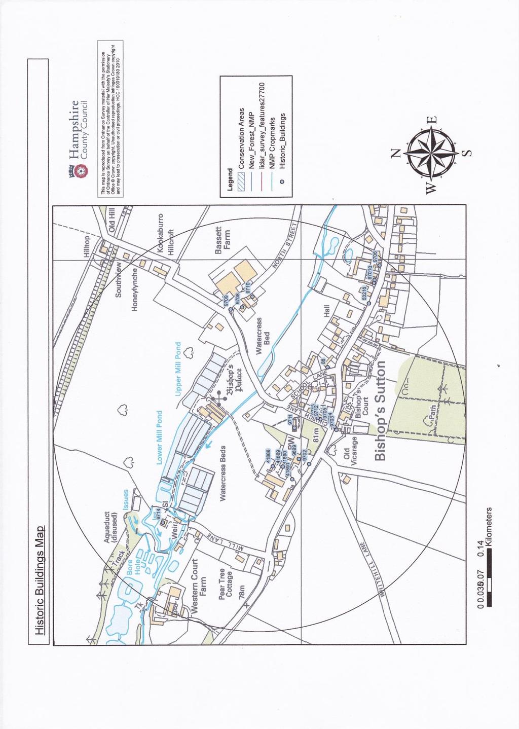
6 2.2. Written Sources (continued) In 1830 remains of the palace were used as a malt house, but only the site remains. The bishops of Winchester kept a kennel from very early times in Bishops Sutton. In the early part of the thirteenth century, mention is made of the expenses of keeping the king s hounds at Bishop s Sutton, which suggests that the king paid frequent visits to the bishop for hunting, and brought his hounds with him. The bishop also had a park in Bishop s Sutton, covering an area of 250 acres, which in 1649 was sold to Sir John Evelyn, together with all the warrens of conies within it. A fair was held at Bishop s Sutton on the Feast of St Giles and the following days from very early days. It seems to have been a popular one, for as long as it lasted seven men acted as constables and two others were employed to guard the woods, presumably against poachers. As late as the of the 19 th century two fairs were held one on the Thursday after Holy Trinity and the other on 6 th November but they seem soon afterwards to have died out. At the time of the Domesday Survey there were four mills, but now there is only one, situated a little to the north-west of the site of the Bishop s palace, and probably occupying the site of the mill which in the reign of Henry VI was situated near the Court of Bishop s Sutton. 2.3 Photographic sources No photographic sources exist of the remains of the bishop s palace at Sutton. There is a map dated 1839 which clearly shows a standing structure on the site of the palace. The map also shows the remains of a mill pond. Standing structure Mill Pond? 6

7 HAMPSHIRE ARCHAEOLOGICAL DOWSERS: BISHOP SUTTON Map of

 Site")
8 HAMPSHIRE ARCHAEOLOGICAL DOWSERS: BISHOP SUTTON 2.3 Photographic sources (continued) Site of the Bishop s Palace (Site One) Site of other structures (Site Two) 8


9 3.0 Survey 3.1 Grid Lay Out. In order to accurately record located underground features and to abide by archaeological best practices, a 10 metre square grid was set up over the both the palace site and over the site of the other feature identified from the Google images to the west. The system involved the use of measuring tapes and pigtails The diagonals of each grid were accurately measured to ensure that each grid was square to an accuracy of 10 cm. The pig-tails were used to identify the corners of each grid. Setting out the 10 metre grid on the palace site. (Site One) Working on the grid on Site Two 9


10 3.2 Dowsing Survey Members of HADS were allocated a series of 10 metre grids to survey. By simply walking across the ground surface it was possible to locate by dowsing the lines of possible walls beneath the surface. At intervals a flag was placed on the ground surface to indicate the location of the possible walls. Extra attention was paid to the corners of possible buildings and possible doorways. Both the corners and doorways were clearly marked by extra flags. To clearly identify possible rooms or buildings, red and white hazard tape was used to mark out any of the features located. These would then be drawn to scale for further reference and then photographed. Buildings on Site One 10


11 3.2 Dowsing Survey (continued) Possible buildings on Site Two 11

12 3.3 Interpretation Over the course of the weekend several possible features or buildings were located. On Site One, substantial walls were located, especially to the south and western side of the site whilst a possible gate-house was located on the northeastern corner of the site. On Site Two, long linear features were recorded. These may have been used as domestic buildings such as barns or storehouses. On both sites, the structures dowsed, marked with flags and the identified with hazard tape before being photographed, recorded and the drawn. 4.0 Results 4.1 Drawn Linear Features All features located were recorded onto graph paper to a specific scale. These drawings were later reproduced in a TurboCad format. These TurboCad diagrams appear in this report as APPENDIX 2. Sketch of possible buildings on the palace site (not to scale) 12

13 4.1 Drawn Linear Features (continued) Sketch of possible buildings under Site Two (not to scale) 5.0 Conclusions and Recommendations. Overall the weekend was a resounding success. Both experienced and novice dowsers were able to locate possible buried walls and features of the Bishop s Palace at Sutton. The two areas of archaeological interest both revealed some evidence of structures, although the features identified on Site Two remain a mystery. The features identified on Site Two are quite substantial and are definitely part of the demolished palace. The recording of these buried structures was satisfactory but more time should have been allocated to record them in greater detail. The laying out and use of the 10 metre grid was a success with some members being trained to carry this exercise out for the first time. A Geophysical Survey would offer the opportunity to check on the dowsing results. Resistivity results taken on other sites have supported HADS findings. Perhaps such a survey could be undertaken in the near future? 13
14 6.0 Acknowledgements Firstly, HADS would wish to thank Mr Peter Mills for his permission to carry out the archaeo-dowsing survey at Bishops Sutton. It is an intriguing site and we are so grateful for opportunity to survey it. We would also like to thank Peter for his interest in the project and for showing us the 1836 map of the palace site. I would also wish to thank all those members of HADS who gave up their time to assist on this weekend of dowsing activity. Without their support this exercise would not have been possible. I would also wish to thank the staff at the Historic Environment Record at the Hampshire County Council for providing the archaeological and historic information on the site. Finally, we owe a vote of thanks to the staff at The Ship Inn for providing meals on the two days of survey and for the use of other facilities. Don Bryan Archaeological Director Hampshire Archaeology Dowsers 14

15 APPENDIX ONE - RISK ASSESSMENT 15
16 APPENDIX TWO - TURBOCAD RESULTS 16
17 17
18 18
19 APPENDIX 3 - HISTORIC ENVIRONMENT RECORD 19
20 20
21 21
Excavations in a Medieval Market Town: Mountsorrel, Leicestershire,
 Excavations in a Medieval Market Town: Mountsorrel, Leicestershire, by John Lucas Mountsorrel is situated 12 kms north of Leicester and forms a linear settlement straddling the A6, Leicester to Derby road.
Remote Sensing into the Study of Ancient Beiting City in North-Western China
 Dingwall, L., S. Exon, V. Gaffney, S. Laflin and M. van Leusen (eds.) 1999. Archaeology in the Age of the Internet. CAA97. Computer Applications and Quantitative Methods in Archaeology. Proceedings of
ROUKEN GLEN: BANDSTAND 2015 DATA STRUCTURE REPORT
 ROUKEN GLEN: BANDSTAND 2015 DATA STRUCTURE REPORT Author (s) Ian Hill Editors Report Date June 2015 Working Partners Funders Phil Richardson East Renfrewshire Council East Renfrewshire Council, Heritage
Long Cairn Divis County Antrim
 Survey Report No. 66 Harry Welsh Long Cairn Divis County Antrim 2 Ulster Archaeological Society 2018 Ulster Archaeological Society c/o School of Natural and Built Environment Queen s University Belfast
Holyport Manor Special School, Highfield Lane, Cox Green, Maidenhead, Berkshire
 Holyport Manor Special School, Highfield Lane, Cox Green, Maidenhead, Berkshire An Archaeological recording action For CgMs Consulting by Jennifer Lowe Thames Valley Archaeological Services Ltd Site Code
Wheatlands House, Fleet Hill, Finchampstead, Berkshire
 Wheatlands House, Fleet Hill, Finchampstead, Berkshire An Archaeological Watching Brief For JCA International by James McNicoll-Norbury Thames Valley Archaeological Services Ltd Site Code WFF 08/26 August
THE HEUGH LINDISFARNE
 LINDISFARNE COMMUNITY ARCHAEOLOGY THE HEUGH LINDISFARNE Archaeological excavations in June 2017 Invitation to volunteers THE HEUGH, LINDISFARNE, NORTHUMBERLAND: ARCHAEOLOGICAL EXCAVATIONS 2017 INTRODUCTION
Archaeological Monitoring at Ham Farm, Ham Road, Faversham, Kent
 Archaeological Monitoring at Ham Farm, Ham Road, Faversham, Kent NGR: 601750.0mE 162695.0mN Site Code HAM/WB/12 Report for A.J. Bray SWAT ARCHAEOLOGY Swale and Thames Archaeological Survey Company The
Cambridge International Examinations Cambridge International General Certificate of Secondary Education
 Cambridge International Examinations Cambridge International General Certificate of Secondary Education *3565143540* GEOGRAPHY 0460/42 Paper 4 Alternative to Coursework May/June 2017 1 hour 30 minutes
CASTLE OF OLD WICK HISTORIC ENVIRONMENT SCOTLAND STATEMENT OF SIGNIFICANCE. Property in Care(PIC) ID: PIC282 Designations:
 ID: PIC282 Designations:") Property in Care(PIC) ID: PIC282 Designations: Scheduled Monument (SM90065) Taken into State care: 1957 (Guardianship) Last reviewed: 2004 HISTORIC ENVIRONMENT SCOTLAND STATEMENT OF SIGNIFICANCE CASTLE
Property in Care(PIC) ID: PIC282 Designations: Scheduled Monument (SM90065) Taken into State care: 1957 (Guardianship) Last reviewed: 2004 HISTORIC ENVIRONMENT SCOTLAND STATEMENT OF SIGNIFICANCE CASTLE
Survey of Littleton Down
 Survey of Littleton Down 05 November 2014 The Team: John and Jenny Barnard 1) Introduction Littleton Down (Hill Number 2911, Section 42, OS 1:50000 Map 197, OS 1:25000 Map 121, Grid Ref. SU941150) is listed
Archaeological Watching Brief at the Brick Stables and Wagon Lodge, Abbey Barns, Abbey Road, Faversham, Kent September 2010
 Archaeological Watching Brief at the Brick Stables and Wagon Lodge, Abbey Barns, Abbey Road, Faversham, Kent September 2010 SWAT. Archaeology Swale and Thames Archaeological Survey Company School Farm
Henderson Mess, RAF Halton, Buckinghamshire
 Henderson Mess, RAF Halton, Buckinghamshire An archaeological watching brief for Stepnell Ltd by Stephen Hammond Thames Valley Archaeological Services Ltd Site Code RHA03/85 October 2003 Summary Site name:
RAILWAY BOUNDARY MARKERS IN GLOUCESTERSHIRE. John Putley
 Reprinted from: Gloucestershire Society for Industrial Archaeology Journal for 2005 pages 52-56 RAILWAY BOUNDARY MARKERS IN GLOUCESTERSHIRE John Putley Recently the author became aware of some railway
Afon Adda Refurbishment Bangor
 Afon Adda Refurbishment Bangor Archaeological Assessment Revised Report GAT Project No. 1876 Report No. 628 April 2006 Ymddiriedolaeth Archaeolegol Gwynedd Gwynedd Archaeological Trust Craig Beuno, Ffordd
Seventh Grade 2003 pg. 4
 Seventh Grade 2003 pg. 4 MARS Tasks - Grade 7 Page 3 Seventh Grade 2003 pg. 14 MARS Tasks - Grade 7 Page 6 Seventh Grade 2003 pg. 15 MARS Tasks - Grade 7 Page 7 Seventh Grade 2003 pg. 30 MARS Tasks - Grade
Cholesbury New House, Parrots Lane, Cholesbury, Buckinghamshire
 Cholesbury New House, Parrots Lane, Cholesbury, Buckinghamshire An Archaeological Watching Brief For Mr Martin Wood by Sean Wallis Thames Valley Archaeological Services Ltd Site Code PLC 06/135 March 2007
Archaeological Investigations Project South East Region SOUTHAMPTON 2/842 (C.80.C004) SU
 SU") SOUTHAMPTON City of Southampton 2/842 (C.80.C004) SU 4382 1336 125 BITTERNE ROAD WEST, SOUTHAMPTON Report on the Archaeological Evaluation Excavation at 125 Bitterne Road West, Southampton Russel, A. D
SOUTHAMPTON City of Southampton 2/842 (C.80.C004) SU 4382 1336 125 BITTERNE ROAD WEST, SOUTHAMPTON Report on the Archaeological Evaluation Excavation at 125 Bitterne Road West, Southampton Russel, A. D
THE SALE OF WADE'S FARM, BARTON STACEY, IN 1894
 THE SALE OF WADE'S FARM, BARTON STACEY, IN 1894 by Linda Moffatt April 2013 for the bartonstaceyhistory@gmail.com www.bartonstaceyhistory.co.uk In 1894 John Wade sold Wade's Farm to George Judd. The sale
USEFUL. SOURCES 1 The Inland Revenue Survey of Land Value and Land Ownership, LOCAL HISTORY. Introduction. Douglas G Lockhart
 USEFUL LOCAL HISTORY SOURCES 1 The Inland Revenue Survey of Land Value and Land Ownership, 1910-1915 Introduction Douglas G Lockhart A survey of all land in Scotland took place between 1910 and 1915 the
Bridgetown. O Briensbridge. Knockadrohid. Ardataggle. Fairyhall. Cappakea. Montpelier. Derryhasna. Aughboy. Drummeen Kildoorus.
 Bridgetown Knockadrohid O Briensbridge had been on the main water- road from Limerick to Dublin from 1799 until the last trading boat passed through in June 1929 From the late eighteenth century it was
FOUNDATIONS OF ARCHAEOLOGY A WALK IN VERNDITCH CHASE
 FOUNDATIONS OF ARCHAEOLOGY A WALK IN VERNDITCH CHASE 1. A Tale of two Long Barrows Long barrows were constructed as earthen or drystone mounds with flanking ditches and acted as funerary monuments during
WALTON MARSH RAILROAD TIES
 WALTON MARSH RAILROAD TIES A PROJECT SURVEY BY COLIN FRYE Supervisor: Dr. Mark Holley The Walton Marsh Railroad Tie project involved the survey and study of six railroad ties discovered in and on the shoreline
Unlocking Our Coastal Heritage Project: Crane Castle Promontory Fort, Illogan, Cornwall
 Unlocking Our Coastal Heritage Project: Crane Castle Promontory Fort, Illogan, Cornwall As part of a wider project funded by the Rural Development Programme for England (RDPE) and administered through
Cambridge International Examinations Cambridge International General Certificate of Secondary Education
 Cambridge International Examinations Cambridge International General Certificate of Secondary Education *0710028496* GEOGRAPHY 0460/23 Paper 2 October/November 2016 Candidates answer on the Question Paper.
Photopoint Monitoring in the Adirondack Alpine Zone
 Photopoint Monitoring in the Adirondack Alpine Zone Julia Goren (PI) and Seth Jones Adirondack High Peaks Summit Steward Program Adirondack Mountain Club summit@adk.org PO Box 867, Lake Placid, NY 12946
The Atlas of Hillforts of Britain and Ireland. Hillfort survey notes for guidance
 The Atlas of Hillforts of Britain and Ireland Hillfort survey notes for guidance The collection of surveys for the Atlas is now finished but you can use this form and the accompanying Notes for Guidance
Powys Local Development Plan. Position Statement - Gypsy and Traveller Accommodation. Incorporating an action statement and implications for the LDP
 Powys Local Development Plan Position Statement - Gypsy and Traveller Accommodation Incorporating an action statement and implications for the LDP September 2016 Powys LDP, Position Statement Gypsy and
CARLUNGIE EARTH HOUSE
 Property in Care (PIC) ID: PIC015 Designations: Scheduled Monument (SM90059) Taken into State care: 1953 (Guardianship) Last reviewed: 2004 HISTORIC ENVIRONMENT SCOTLAND STATEMENT OF SIGNIFICANCE CARLUNGIE
An archaeological evaluation at 14 Vineyard Street, Colchester, Essex March 2006
 An archaeological evaluation at 14 Vineyard Street, Colchester, Essex March 2006 report prepared by Ben Holloway commissioned by Colchester Borough Council CAT project code: 06/4b Colchester Museums accession
Society Member to Supervise the Building of James Monroe s Birthplace House Charles Belfield, a councilor of the War of 1812 Society in the
 Society Member to Supervise the Building of James Monroe s Birthplace House Charles Belfield, a councilor of the War of 1812 Society in the Commonwealth of Virginia has been designated as the supervisor
Seek the Board s approval for the Donald Place kerb and channel renewal to progress to final design, tender and construction; and
 3. DONALD PLACE - KERB AND CHANNEL RENEWAL General Manager responsible: General Manager City Environment Officer responsible: Transport and City Streets Manager Author: Michelle Flanagan, Streets Capital
Amarna Workers Village
 Amarna Workers Village The Egyptian city of Amarna was the pet building project of the pharaoh Akhenaten, who oversaw construction of his new capital between 1346 and 1341 BCE. The city was largely abandoned
Middle Row: Part of a Georgian Industrial Settlement in Cark in Cartmel, Cumbria Les Gilpin
 Middle Row: Part of a Georgian Industrial Settlement in Cark in Cartmel, Cumbria Les Gilpin The Georgian rows of of High Row and Low Row which sit alongside ' Cark Beck' (river Eea) in the hamlet of Cark
Lordenshaw. What are cup & ring marks?
 Lordenshaw Lordenshaw hill has one of the largest clusters of ancient cup and ring marked stones in the UK. We ve chosen four interesting spots we d like to share with you. What are cup & ring marks? The
Documentation of Mosaic Tangible Heritage in Jordan Jarash Governorate
 Documentation of Mosaic Tangible Heritage in Jordan Jarash Governorate Catreena Hamarneh, Abdel Majeed Mjalli, Mohamed al-balawneh Introduction In the year 2005 a project was launched to build up a data
Clarendon Palace, Wiltshire: archaeology and history (notes for visitors, prepared by the Royal Archaeological Institute, 2017)
") Clarendon Palace, Wiltshire: archaeology and history (notes for visitors, prepared by the Royal Archaeological Institute, 2017) Clarendon Palace was probably the most spacious royal residence in England
Clarendon Palace, Wiltshire: archaeology and history (notes for visitors, prepared by the Royal Archaeological Institute, 2017) Clarendon Palace was probably the most spacious royal residence in England
SAFEGUARDING OF AERODROMES. Advice Note 1
 AIRPORT OPERATORS ASSOCIATION & GENERAL AVIATION AWARENESS COUNCIL supported by CIVIL AVIATION AUTHORITY Working in Co-operation SAFEGUARDING OF AERODROMES Advice Note 1 Safeguarding - An Overview 1. The
High Winder House & Holiday Cottages Tirril, Penrith, Cumbria, CA10 2LS Lake District National Park
 High Winder House & Holiday Cottages Tirril, Penrith, Cumbria, CA10 2LS Lake District National Park High Winder House, Tirril Page 4 of 16 High Winder House & Holiday Cottages An attractive 17 th Century
Bartlett Square Welcome. Investment Framework. London Airport Ltd
 1 Welcome Welcome to Luton s public exhibition on proposals for the (formerly known as Stirling Place) project which will comprise 2.5 acres of commercial development, providing up to 2,000 jobs for local
Survey of An Dun. 24th March The Team: John Barnard and Graham Jackson.
 Survey of An Dun 24th March 2012 The Team: John Barnard and Graham Jackson. 1) Introduction An Dun (Section 5B, OS 1:50000 Map 42, Grid Ref. NN717805) is a Corbett and a Marilyn. This mountain has two
Appendix 7 Local Green Spaces - Detailed Evidence
 Appendix 7 Local Green Spaces - Detailed Evidence Neigh Bridge Country Park, Somerford Keynes General information Neigh Bridge Country Park is situated at the southern entrance to Somerford Keynes village.
4. Bronze Age Ballybrowney, County Cork Eamonn Cotter
 4. Bronze Age Ballybrowney, County Cork Eamonn Cotter Illus. 1 Location map of the excavated features at Ballybrowney Lower (Archaeological Consultancy Services Ltd, based on the Ordnance Survey Ireland
Aboriginal and Torres Strait Islander Life Expectancy and Mortality Trend Reporting
 Aboriginal and Torres Strait Islander Life Expectancy and Mortality Trend Reporting Technical Report December 2015 Amended May 2016 Authors: Clare Coleman, Nicola Fortune, Vanessa Lee, Kalinda Griffiths,
Whilst we have limited resources we will continue to place more emphasis on the conservation area but we will also comment on other applications
 Whilst we have limited resources we will continue to place more emphasis on the conservation area but we will also comment on other applications within the Town Council's area, where we see good reason
ROLLER COASTER POLYNOMIALS Due: Thursday, March 30th
 ROLLER COASTER POLYNOMIALS Due: Thursday, March 30th Purpose: In real life, polynomial functions are used to design roller coaster rides. In this project, you will apply skills acquired in Unit 3 to analyze
An archaeological watching brief on land adjacent to 50 Rosebery Avenue, Colchester, Essex May/June 2003
 An archaeological watching brief on land adjacent to 50 Rosebery Avenue, Colchester, Essex May/June 2003 report prepared by C Crossan on behalf of Highfield Homes Ltd NGR: TM 0035 2500 CAT project ref.:
Ground Penetrating Radar Survey Report:
 Ground Penetrating Radar Survey Report: German Hospice in Jerusalem, Israel Data Acquired June 19, 2003 Report compiled August 26, 2003 Survey and Report Published by Mnemotrix Systems, Inc. Copyright
Brucklay Castle, Maud, Aberdeenshire
 Brucklay Castle, Maud, Aberdeenshire Brucklay Castle, Maud Aberdeenshire A chance to restore an historic Castle in North East Scotland Maud 2 miles Aberdeen 29 miles Full planning and Listed Building consent
Tahquitz Canyon Data Recovery Project
 http://oac.cdlib.org/findaid/ark:/13030/kt500037fc No online items Agua Caliente Cultural Museum 901 E Tahquitz Canyon Way Ste C-204 Palm Springs, California 92262 Phone: (760) 778-1079 Fax: (760) 322-7724
The Old Shire Horse Centre, Bath Road, Woolley Green, Maidenhead, Berkshire
 The Old Shire Horse Centre, Bath Road, Woolley Green, Maidenhead, Berkshire An Archaeological Watching Brief For Mr Derek Chesterman by Andrew Mundin Thames Valley Archaeological Services Ltd Site Code
HENLEAZE, STOKE BISHOP & WESTBURY-ON-TRYM NEIGHBOURHOOD PARTNERSHIP September Chock Lane Traffic Calming scheme Monitoring Report
 HENLEAZE, STOKE BISHOP & WESTBURY-ON-TRYM NEIGHBOURHOOD PARTNERSHIP September 2015 Title: Officer: Chock Lane Traffic Calming scheme Monitoring Report Rob Grieve, Principal Officer, Highways and Traffic,
THE BUILDING OF SUTTON PLACE. SIR RICHARD WESTON S GRAND DESIGN.
 A lot THE BUILDING OF SUTTON PLACE. SIR RICHARD WESTON S GRAND DESIGN. Iain Wakeford 2014 of people refer to Sutton Place, Guildford but the house (and indeed the village of Sutton Green) is firmly in
Local Development Scheme
 Local Development Scheme August 2014 Local Development Scheme (August 2014) / Page 2 Contents Section 1: Introduction Great Yarmouth s Development Plan 4 Section 2: Plan Making Process Public participation
ROLLER COASTER POLYNOMIALS
 Math 3 Honors ROLLER COASTER POLYNOMIALS (PART 1: Application problems small group in class) (PART 2: Individual roller coaster design) Purpose: In real life, polynomial functions are used to design roller
The footpaths in Eaves Wood, Mytholm, Hebden Bridge. Dedicating historic paths as rights of way: submission by Hebden Bridge Walkers Action
 The footpaths in Eaves Wood, Mytholm, Hebden Bridge Dedicating historic paths as rights of way: submission by Hebden Bridge Walkers Action Summary This submission to Calderdale MBC proposes that the council
Stobs Camp Project Quarter 1 Report April June 2018
 Stobs Camp Project Quarter 1 Report April June 2018 Executive Summary During this period the project ran an excavation at two fortification practice trenches. Adult volunteers and school pupils were able
Survey of Deadwater Fell and Peel Fell
 4 December 2014 Survey of Deadwater Fell and Peel Fell Team: John Barnard, Chris Crocker, Richard Cooper and Graham Jackson 1) Introduction Deadwater Fell (Hill 3542, Section 33, OS 1:50000 Map 80, OS
Manor Court LONG SUTTON, HAMPSHIRE
 Manor Court LONG SUTTON, HAMPSHIRE Manor Court LONG SUTTON, HAMPSHIRE Stunning contemporary conversion in prime Hampshire village Reception hall drawing room with open fireplace Fabulous kitchen open plan
Street Based Lifestyle Monitor
 Street Based Lifestyle Monitor Cardiff (October 2013-October 2015) 0 Executive Summary Those living a street based lifestyle are the public face of homelessness and yet accurate data around how many people
Cooloolabin Dam Recreation Management Discussion Paper. November 2013
 Cooloolabin Dam Recreation Management Discussion Paper November 2013 Contents November 2013... 1 Background... 3 Overview of Cooloolabin Dam... 6 Weed Management... 7 Cultural Heritage... 7 Commercial
Ancient Egypt - Hatshepsut
 Name Date Class Ancient Egypt - Hatshepsut The Queen Who Was King Social Studies 8B A PROPOSAL TO: Mr. K. Burgess Group: March 13/20, 2012 In the midst of the past, one of the most technological and advanced
Castleton and Its Old Inhabitants.
 Castleton and Its Old Inhabitants. Chapter 6. The Churchyard-side buildings on Castle Street. Part of Castle Street has changed somewhat over the years, mainly due to the earlier presence of a little row
Year 10 Mathematics Examination SEMESTER
 STUDENT NAME: TEACHER: DATE: Year 10 Mathematics Examination SEMESTER 2 2016 QUESTION AND ANSWER BOOKLET TIME ALLOWED FOR THIS PAPER Reading time before commencing work: 10 minutes Working time for this
o a London Borough of Barnet Stoney Wood Lake Silk Stream Flood Alleviation Scheme Archaeological Watching Brief Report Oxford Archaeology
 Silk Stream Flood Alleviation Scheme Stoney Wood Lake London Borough of Barnet Archaeological Watching Brief Report o a Oxford Archaeology November 2004 Client: Halcrow on behalf of Environment Agency
New Archaeological Discoveries South of the Hanyuan Hall at the Daming Palace of Tang Dynasty
 New Archaeological Discoveries South of the Hanyuan Hall at the Daming Palace of Tang Dynasty The Xi an Tang City Archaeology Team, IA, CASS Key words: Imperial Palaces-China-Tang Dynasty Hanyuan Hall
Math 3 Polynomials Project
 Math 3 Polynomials Project ROLLER COASTER POLYNOMIALS Application Problems and Roller Coaster Design due NO LATER THAN FRIDAY, JAN 13. Projects handed in after this date will receive a 0. Purpose: In real
In September, 1966, an
 ANNE S. ROBERTSON, D LITT THE ROMAN CAMP(S) ON HILLSIDE FARM, DUNBLANE, PERTHSHIRE This paper is published with the aid of a grantfrom H.M.Treasury In September, 1966, an emergency excavation was begun,
MP : The Big Chief Overlook and the Glen
 MP 253 254: The Big Chief Overlook and the Glen The mile between MP 253 and 254 has lots of history in it. It includes the only recorded remains of the Victory Highway on the Clear Creek County side of
Provincial Archaeology Office Annual Review
 2017 Provincial Archaeology Office Annual Review Provincial Archaeology Office Department of Tourism, Culture, Industry and Innovation Government of Newfoundland and Labrador March 2018 Volume 16 A brief
LAND AT STRATHAVEN GOLF CLUB
 FOR SALE RESIDENTIAL DEVELOPMENT LAND AT GOLF CLUB GLASGOW ROAD,, ML10 6LZ Greenfield site extending to approximately 0.78 hectares (1.92 acres) Located in Strathaven, a sought after South Lanarkshire
The Coach House, Mill Lane, Cookham, Berkshire
 The Coach House, Mill Lane, Cookham, Berkshire An Archaeological Watching Brief For Ms Sophia Butler by Stephen Hammond Thames Valley Archaeological Services Ltd Site Code CMC 03/104 October 2003 Summary
Kingship in the Mycenaean World and Its Reflections in the Oral Tradition
 Kingship in the Mycenaean World and Its Reflections in the Oral Tradition Photograph of George E. Mylonas taken by his daughter at Mycenae, Easter 1975. PREHISTORY MONOGRAPHS 13 Kingship in the Mycenaean
I I I I LINDEN TO WOOD FORD SURVEY ITEMS OF HISTORICAL SIGNIFICANCE I I I I I I I I I I I I I
 LNDEN TO WOOD FORD SURVEY TEMS OF HSTORCAL SGNFCANCE ------------------------------------------------------------------------------ --- - CONTENTS OF THE REPORT 1.0 ntroduction to the Report 1.1 Parameters
In need of some modernisation or further development
 11 Market Place Bingham Nottingham NG13 8AR Tel: (01949) 87 86 85 bingham@hammondpropertyservices.com With possible links to the discovery of Tutankhamun! 8 CHERRY STREET, BINGHAM, NOTTINGHAM NG13 8AJ
Vision for Kirkholt. Our proud history. From ancient knights to Victorian landmarks
 Vision for Kirkholt Our proud history From ancient knights......to Victorian landmarks Take the family heritage trail to discover historical gems on your doorstep See map inside FREE STICKERS! The Vision
Robertson. park. heritage walk. Whitney Fountain
 Robertson park heritage walk Whitney Fountain History of Robertson park Five acres (2.2 hectares) was reserved for water purposes in the centre of Orange and was gazetted for public recreation on 13 May
REAUTHORISATION OF THE ALLIANCE BETWEEN AIR NEW ZEALAND AND CATHAY PACIFIC
 Chair Cabinet Economic Growth and Infrastructure Committee Office of the Minister of Transport REAUTHORISATION OF THE ALLIANCE BETWEEN AIR NEW ZEALAND AND CATHAY PACIFIC Proposal 1. I propose that the
Henbury s Great House. By Andrew Michael Chugg
 Henbury s Great House By Andrew Michael Chugg A Key Source on Henbury s Great House Transactions of the Bristol and Gloucestershire Archaeological Society The Owners of the Great House, Henbury, Gloucestershire
Stone Mills. Rob Arkell: Trowbridge Archaeology Group
 Stone Mills Rob Arkell: Trowbridge Archaeology Group Stone Mills Main Building 2013 A mill linked to Trowbridge Castle stood on the site of Stone Mills as far back as 1331 and the site was acquired by
Economic Impact of Tourism. Norfolk
 Economic Impact of Tourism Norfolk - 2009 Produced by: East of England Tourism Dettingen House Dettingen Way, Bury St Edmunds Suffolk IP33 3TU Tel. 01284 727480 Contextual analysis Regional Economic Trends
Archaeological Watching Brief on land at Alpha, Gore Road, Eastry, Kent July 2010
 Archaeological Watching Brief on land at Alpha, Gore Road, Eastry, Kent July 2010 SWAT. Archaeology Swale and Thames Archaeological Survey Company School Farm Oast, Graveney Road Faversham, Kent ME13 8UP
Following the initial soil strip archaeology is sprayed up prior to planning and excavation
 Barton Quarry & Archaeology Over the past half century quarries have been increasingly highlighted as important sources of information for geologists, palaeontologists and archaeologists, both through
The Battle of Quebec: 1759
 The Battle of Quebec: 1759 In the spring of 1759, the inhabitants of Quebec watched the river with worried eyes. They waited anxiously to see whether the ships of the French, or those of the British fleet,
The Last resting Place of George and Anne Goodison
 The Last resting Place of George and Anne Goodison Some years ago, I published an article concerning the life of the man who gave his name to the home ground of Everton FC and made an unqualified assumption
CAMPER CHARACTERISTICS DIFFER AT PUBLIC AND COMMERCIAL CAMPGROUNDS IN NEW ENGLAND
 CAMPER CHARACTERISTICS DIFFER AT PUBLIC AND COMMERCIAL CAMPGROUNDS IN NEW ENGLAND Ahact. Early findings from a 5-year panel survey of New England campers' changing leisure habits are reported. A significant
TRANSACTIONS. 27 BY R. L. HOWARD, ESQ., AND THE REV. H. FOWLER.
 TRANSACTIONS. 27 BY R. L. HOWARD, ESQ., AND THE REV. H. FOWLER. In reference to the history of this house, it may first be noted that John Heyworth, No. 3, the last of his name, who inherited it, died
Baslow & Bubnell Page 1 of 5 A Comparison
 Baslow & Bubnell Page 1 of 5 Introduction This paper describes the number of houses in Baslow and Bubnell from 1670 up to the present day. Most of the data was obtained by counting the buildings on a series
Aboriginal and Torres Strait Islander Life Expectancy and Mortality Trend Reporting to 2014
 Aboriginal and Torres Strait Islander Life Expectancy and Mortality Trend Reporting to 2014 Technical Report June 2016 Authors: Clare Coleman, Nicola Fortune, Vanessa Lee, Kalinda Griffiths, Richard Madden
ALL FIELD HOCKEY ACTIVITIES ARE HIGHLIGHTED IN RED.
 England #1 Field Hockey Tour London 9 Day / 7 Night Program www.victorysportstours.com SUGGESTED PROGRAM PLEASE NOTE: Actual sequence and timing of activities will revolve around your game & practice schedule,
Wessex Archaeology. Little Stubbings, West Amesbury, Salisbury, Wiltshire. Archaeological Watching Brief. Ref:
 Wessex Archaeology Little Stubbings, West Amesbury, Salisbury, Wiltshire Ref: 63280.02 March 2007 LITTLE STUBBINGS, WEST AMESBURY, NR SALISBURY, WILTSHIRE ARCHAEOLOGICAL WATCHING BRIEF Prepared for: P
Oak Ridges Moraine: Southern Ontario's Sponge
 Oak Ridges Moraine: Southern Ontario's Sponge Lesson Overview Students will examine the location and the importance of the Oak Ridges Moraine and investigate ongoing conflicts concerning its development.
w w w. d r a k e s - i s l a n d. c o m
 w w w. d r a k e s - i s l a n d. c o m 1 A Piece of History Named after Plymouth s most famous patron and situated in the heart of Plymouth Sound, Drake s Island has a rich history having been a religious
Produced by: Destination Research Sergi Jarques, Director
 Produced by: Destination Research Sergi Jarques, Director Economic Impact of Tourism Norfolk - 2017 Contents Page Summary Results 2 Contextual analysis 4 Volume of Tourism 7 Staying Visitors - Accommodation
The Archaeology of Cheltenham
 The Archaeology of Cheltenham The archaeology collection of The Wilson contains a rich quantity of material relating to the prehistoric and Roman occupation of the North Cotswolds and parts of the Severn
Northamptonshire Archaeology
 Northamptonshire Archaeology A programme of archaeological observation, investigation and recording at St Andrews Church, Spratton, Northamptonshire Northamptonshire Archaeology 2 Bolton House Wootton
Original Report F WIN , F WIN Prepared for Northland Power and Ministry of Tourism and Culture
 STAGE 2 ARCHAEOLOGICAL ASSESSMENT McLEAN S MOUNTAIN WIND FARM Part Lots 12-15, Concession 3 Geographic Township of Howland Part Lot 24, Concession 12 Geographic Township of Bidwell and Goat Island (formerly
Saighton Camp, Chester. Technical Note: Impact of Boughton Heath S278 Works upon the operation of the Local Highway Network
 Technical Note: Impact of Boughton Heath S278 Works July 2013 SAIGHTON CAMP CHESTER COMMERCIAL ESTATES GROUP TECHNICAL NOTE: IMPACT OF BOUGHTON HEATH S278 WORKS UPON THE OPERATION OF THE LOCAL HIGHWAY
The never before seen pictures of Tower Bridge - one of the world's most recognisable structures - have been unveiled
 Pictures of Tower Bridge during construction found dumped in a skip This is one of the London's most beloved landmarks as you've never seen her before. The never before seen pictures of Tower Bridge -
AMAS 05. Mine/UXO Clearance Marking System. Second Edition June 2007
 Mine/UXO Clearance Marking System MACCA House#95, Street Jeem, Wazir Akbar Khan Avenue Kabul, Afghanistan E-mail: mapa@macca.org Afghanistan Mine Action Standards 5-1 CONTENTS AMENDMENT RECORD... 4 05.1