Mount Rainier National Park November 2006 Flood Damage
|
|
|
- Samson Mathews
- 5 years ago
- Views:
Transcription

1 On November 6 and 7, 2006, Mount Rainier National Park received 18 inches of rain in 36 hours. This presentation summarizes the extensive flood damage that occurred throughout the park. Updated November 16, 2006
2 Sunshine Point The section of dike which protected Sunshine Point Campground was destroyed in the flood. Only a small section of the campground remained. The rest is now river bed. The Nisqually Road was washed out for 200 yards. The main power line (serving Longmire and Paradise) was severed where it crossed Sunshine Point.
3 The Nisqually Road and site of the former Sunshine Point Campground

4 Most of the campground and adjacent road were washed away

5 Water flowing through the remains of the Sunshine Point Campground

6 The broken edge of the Nisqually Road

7 Former shoreline An aerial view of the former Sunshine Point Campground
8 New shoreline Satellite image of the Sunshine Point Campground, showing new shoreline


9 Former shoreline New and former shoreline at Sunshine Point Campground
10 Westside Road Water crossed the Westside Road at its junction with the Nisqually Road. Parts of both roads were washed out. Part of a lane collapsed near the gate at Dry Creek. The roadway upstream was significantly damaged.

11 Washout at the beginning of the Westside Road

12 Damage to the Nisqually Road across from the Westside Road junction
13 Kautz Creek Kautz Creek changed its channel a mile above the road bridge, and is now flowing over and undermining the Nisqually Road for a distance of 50 yards. The Kautz Helibase sustained major erosion damage from the redirected water flow.


14 New channel Nisqually Road Bridge Kautz Bridge, 1 mile downstream New creek channel N Old Kautz Creek channel Kautz Creek changed its channel a mile above the road bridge

15 Kautz Creek flowing across the road east of the bridge

16 Kautz Creek continues to erode the edges of the Nisqually Road

17 The new creek channel flows through the middle of the Kautz Helibase
18 Longmire Approximately 200 feet of primary sewer line were destroyed. A corner of the Emergency Operations Center was undercut by the river. Its parking lot was destroyed. The power lines across the river to the Community Building were knocked out. The access road to the Community Building and back gate was eroded down to one lane in several places. Excessive sediment collected in all system filters between Longmire and Paradise. The Edith Creek Basin water supply at Paradise was filled with rocks and dirt.

19 The Emergency Operations Center at Longmire, during the flood

20 The Emergency Operations Center after the flood. The parking lot is destroyed.

21 An aerial view of Longmire and the Nisqually River

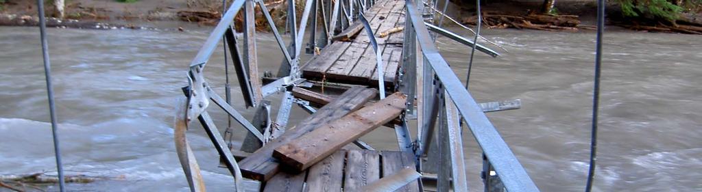
22 The road to the Community Building and back gate was washed out

23 A new view, and reduced parking, in front of the Community Building

24 The road to the back gate is no longer one lane, but caution is still advised
25 Nisqually to Paradise Road The Nisqually Road was reduced to one lane at milepost 5. The embankment is undercut and needs to be rebuilt. The embankment dropped away at milepost 9, leaving a sheer road edge and precipitous drop off. Small landslides deposited debris on the road in several places.

26 Landslide above Glacier Bridge on the Paradise Road
27 Stevens Canyon Road Major slides blocked the road at mileposts 5.5 and 7. A large slide above the Ohanapecosh Campground damaged the Stevens Canyon Road above it in two places.

28 Landslide below Stevens Ridge in Stevens Canyon
29 The Grove of the Patriarchs The suspension bridge accessing the Grove was heavily damaged. The Grove itself was buried in a thick layer of mud. The boardwalk trail was displaced and damaged in numerous places.


30 The damaged suspension bridge

31 The boardwalk trails have been haphazardly realigned


32 The grove was blanketed in three feet of mud
33 Ohanapecosh Campground A 5,000 foot long landslide below Stevens Canyon Road is visible across the river from C loop. Debris created a major logjam downstream. Erosion and falling trees destroyed several campsites and damaged the road in C loop. The Ohanapecosh Visitor Center sustained water damage from minor flooding.


34 The landslide stretches 5,000 feet between Stevens Canyon Road and the river

35 The view from C loop is dramatic

36 The walk-in campsites behind this marker were washed away

37 Picnic table, for scale An enormous logjam formed below the Ohanapecosh Campground

38 Destroyed picnic table at site C-18
39 Highway 123 A large washout occurred near Panther Creek, and a debris flow crossed the road near milepost 11. A major washout cut a channel 60 feet wide and up to 80 feet deep across both lanes at milepost A portion of the road washed out just south of Cayuse Pass. Highway 123

40 Washout Highway on Highway near Panther Creek

41 Milepost Highway on Highway 123

42 Washout at milepost 11.5 on Highway 123

43 The washout at milepost 11.5 is about 80 feet deep

44 Inspecting the damaged road
45 Highway 410 and White River Campground The White River flooded the highway for several miles both inside and outside the park boundary. Park facilities were not significantly damaged. Small sections of the downhill lane sloughed off going into White River Campground. Some sites in A loop were damaged.


46 Flooding and fallen trees on Highway 410 near the park entrance

47 The road into the White River Campground
48 Carbon River and Ipsut Creek Campground More than two miles of road were lost. There are washed out sections in at least four places, and the Carbon River is now flowing down the road for half a mile. The Ipsut Creek Campground was inundated. The full extent of its damage is unknown. A deep erosion gully has undermined the Ipsut Cabin.

49 The Carbon River, flowing down the Carbon River Road

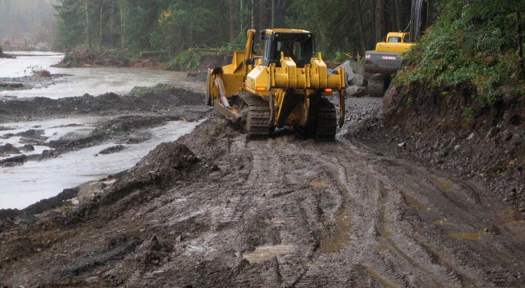
50 One of several gaps in the road near Ipsut Creek

51 The historic Ipsut Creek Cabin was undercut by the river


52 The cabin is now surrounded by a sea of mud

53 The end of the road at Ipsut Creek Campground


54 Parkwide Trail Damage Backcountry bridges and trails sustained extensive damage. Sections of the Wonderland Trail will likely be unusable next summer. At least 10 log bridges and 450 yards of river bar trail are gone. A new graded trail is needed in at least four places, including a half mile to be cut from bedrock between Lake James and Cataract Creek and a 750 foot reroute in Stevens Canyon. The full extent of damage will not be known until trails melt out next summer.

55 A missing section of the Carbon Glacier trail

56 The Silver Falls bridge was heavily damaged
57 Repairs Repair work has begun, primarily in the Nisqually to Paradise corridor. The road is being rebuilt at Sunshine Point. Washouts are being repaired and shored up at several places along the road. New electrical and sewer lines are being installed at Longmire. Maintenance rangers will attempt to coax Kautz Creek back into its former channel. Repairs will continue through the winter. Many places will be inaccessible until snowmelt next summer.
58 Reconstruction begins at Sunshine Bend

59 Rebuilding the Nisqually Road

60 Mount Rainier is a restless mountain. The roads, bridges, trails, and campgrounds we build are secondary to the elemental forces that created and continue to transform this landscape we love. Our great works of human enterprise will fade away with time. The mountain will endure.
Rogue Gorge (Mt. Stella) Roadless Area-- T30S R3E (primarily in portions of Sections 23, 26, 33, 34 & 35)
 Roadless Area-- T30S R3E (primarily in portions of Sections 23, 26, 33, 34 & 35)") Rogue Gorge (Mt. Stella) Roadless Area-- T30S R3E (primarily in portions of Sections 23, 26, 33, 34 & 35) Rogue River-Siskiyou National Forest--High Cascades Ranger District Upper, higher elevation trail
Rogue Gorge (Mt. Stella) Roadless Area-- T30S R3E (primarily in portions of Sections 23, 26, 33, 34 & 35) Rogue River-Siskiyou National Forest--High Cascades Ranger District Upper, higher elevation trail
II. THE BOULDER CREEK DRAINAGE BASIN
 II. THE BOULDER CREEK DRAINAGE BASIN This section provides an overview of the watersheds and flood hazards associated with Boulder Creek and South Boulder Creek including descriptions of the drainage basins,
Bear Creek Habitat Improvement Project
 06/10/10 Bear Creek Habitat Improvement Project El Paso County, Colorado Pike National Forest and Colorado Springs Utilities Owned Land Report prepared by: Eric Billmeyer Executive Director Rocky Mountain
GILBERT & WEST TOWN INTERCOUNTY DRAIN Windsor Township, Eaton County and City of Lansing, Delhi Township, Ingham County, Michigan
 GILBERT & WEST TOWN INTERCOUNTY DRAIN Windsor Township, Eaton County and City of Lansing, Delhi Township, Ingham County, Michigan PRELIMINARY ENGINEERING REPORT Abigail Eaton, Chair Intercounty Drains
KP Lasnaya 1 River
 KP 370.2 Lasnaya 1 River The Lasnaya 1 River crossing is protected by Reno mattings and a gabion wall on the north bank (Photo 1). The south bank consists of natural river gravel deposits on top of Reno
Other Agencies and Organizations
 Daniel Boone National Forest 1700 Bypass Road WInchester, KY 40391 859-745-3100 Location Northern terminus is near Morehead, Kentucky. Southern terminus is located in the Big South Fork NRRA in Tennessee.
Hazard Annex Landslide
 Hazard Annex Landslide Northeast Oregon Multi-Jurisdictional Natural Hazard Mitigation Plan Page P-1 3 Northeast Oregon Natural Hazard Risk Reduction Plan Debris Flow Areas 82 84 La Grande Enterprise Legend
Cr./Left Fork of Boulder Creek/Horse Creek Made it 2.2 miles from Hwy on Left fork of Boulder Creek. Heavy washout;
 Road Inspector Inspection Inspection Date North Fork Mark M. 6/7 Open Boulder Cr. Helitack 6/16 no signs on either section of Boulder Cr. 2) we were able to make it to the creek crossing on Boulder Cr.
Principle Causes of Dam Failures. Structural failure. Cracking. Stability failure. BIA Summer Water Resources Training Dam Safety Inspections
 BIA Summer Water Resources Training Dam Safety Inspections Principle Causes of Dam Failures Part 2 Dam Failures July 28, 2012 Presented by Michael Johnson, Ph.D., P.E. Overtopping Structural failure Stability
Stein Valley Nlaka pamux Heritage Park
 Stein Valley Nlaka pamux Heritage Park - Trail Information Update and Winter Advisory November 2017 March 2018 Welcome to Stein Valley Nlaka pamux Heritage Park! **This trail update is to inform park users
Driving Time: 3 hours (allow extra time for stops)
") Scenic Byways loop This journey takes visitors through the eastern edge of Mt. Rainier National Park and along two of Washington s most beloved scenic byways, the Chinook Byway and the White Pass Scenic
Scenic Byways loop This journey takes visitors through the eastern edge of Mt. Rainier National Park and along two of Washington s most beloved scenic byways, the Chinook Byway and the White Pass Scenic
Non-motorized Trail Plan & Proposal. August 8, 2014
 Town of Star Valley Ranch, Wyoming and the Star Valley Ranch Association in partnership with the USDA Forest Service, Bridger-Teton National Forest, Greys River Ranger District Non-motorized Trail Plan
APPENDIX D: SUSTAINABLE TRAIL DESIGN. APPENDICES Town of Chili Parks and Recreation Master Plan Update
 APPENDIX D: SUSTAINABLE TRAIL DESIGN APPENDICES Town of Chili Parks and Recreation Master Plan Update Sustainable Trail Construction Sustainable trails are defined by the US Forest Service as trails having
KETTLEBOWL - Distance: Approximately 13 miles Highway 52 to Polar at Highway 64.
 LANGLADE COUNTY ICE AGE NATIONAL SCENIC TRAIL CONDITIONS (As of September 7, 2017) Due to situations beyond the control of the Langlade County Chapter of the Ice Age Trail Alliance, conditions are constantly
Trail Phasing Plan. Note: Trails in the Clear Creek Canyon area (Segments will be finalized in the future to minimize wildlife impacts
 Note: Trails in the Clear Creek Canyon area (Segments 2 5 and a future JCOS connection) will be finalized in the future to minimize wildlife impacts Trail Phasing Plan P Parking 3 Easy Trail Intermediate
LANGLADE COUNTY ICE AGE NATIONAL SCENIC TRAIL CONDITIONS (As of May 18, 2017)
") LANGLADE COUNTY ICE AGE NATIONAL SCENIC TRAIL CONDITIONS (As of May 18, 2017) Due to situations beyond the control of the Langlade County Chapter of the Ice Age Trail Alliance, conditions are constantly
LANGLADE COUNTY ICE AGE NATIONAL SCENIC TRAIL CONDITIONS (As of May 18, 2017) Due to situations beyond the control of the Langlade County Chapter of the Ice Age Trail Alliance, conditions are constantly
MP : Snowy Range Road and the Hoop Creek Bridge
 MP 246 247: Snowy Range Road and the Hoop Creek Bridge This section of U. S. Highway 40 contains a Colorado treasure, a great photo op, and a historical landmark all at one stop. It s the Hoop Creek Stone
Agenda Report. Spruce Street Outlet Drainage Improvements Tower Road Relief Sewer
 Agenda Report Subject: Prepared By: Spruce Street Outlet Drainage Improvements Tower Road Relief Sewer Steven M. Saunders, Director of Public Works/Village Engineer Date: August 12, 2012 On March 8, 2012
Itinerary: West Side Loop
 Itinerary: West Side Loop Length: 115 miles Driving Time: 3 hours (allow extra time for stops) Open Season: The route is usually snow-free by the end of May and remains open through October. The road closes
Difficult Run Stream Valley Park
 Difficult Run Stream Valley Park The more intense mountain bikers have known about for Difficult Run for some time. Equestrians have known it longer. Eight miles of unpaved trail, the Rails to River Trail
Marble: 7:09 am Creede: 1:01 pm Today s Airtime: 5.8 hrs Cartographic length 351 miles. Total PIC Time: Total Logged Time 1623.
 Monday, September 11, 2017 Cobra flight #600, PIC #613, 1 landings Misty Meadows, Clear Creek Falls, Lost Lakes, Ute Ridge, Silex, Rio Grande Pyramid, Hossick Lake, Pagosa Peak, Chama Headwaters and Falls,
The Physical Geography of Long Island
 The Physical Geography of Long Island A Bit About Long Island Length 118 miles Brooklyn to Montauk Geo202 Spring 2012 Width 23 miles at it s widest Area 1,400 square miles Formation of Long Island River
Trail Assessment Report
 Trail Assessment Report Trail Options for the Bear Creek Canyon located in Pikes Peak Ranger District, Pike National Forest and on Colorado Springs Utility Lands Due to the presence of a unique species
January 19, 2018 Project No C Via
 Mr. Thomas McDonald, P.E. Professional Engineer II (C/E) Water Management NYS Canal Corporation 30 S Pearl Street Albany, NY 12207 January 19, 2018 Project No. 16-5719C Via email: thomas.mcdonald@canals.ny.gov
Project Report Volunteer Trip Torres del Paine National Park, Patagonia, Chile December 3-15, Executive Summary
 Conservation Volunteers International Program 120 Village Square #9, Orinda, California 94563 USA www.conservationvip.org info@conservationvip.org Tel: (925) 228-5946 A Non-Profit 501c3 Tax Exempt Organization
The Galveston Seawall
 Coastal and Ocean Engineering ENGI.8751 Undergraduate Student Forum Faculty of Engineering and Applied Science, Memorial University, St. John s, NL, Canada. March, 2013 The Galveston Seawall Mark Harvey
Erskine Creek via Pisgah Rock and Jack Evans
 Erskine Creek via Pisgah Rock and Jack Evans 4 hrs 30 mins 7.1 km Circuit Very experienced only 6 421m This walk visits some great lookouts and explores the lower section of Erskine Creek. Most of the
GOLDEN EARS PROVINCIAL PARK
 GOLDEN EARS PROVINCIAL PARK Trail Information as of October 10 th 2015 Do not underestimate the mountainous wilderness of Golden Ears Provincial Park. The combination of rugged terrain and rapidly changing
LITTLE LOST MAN CREEK (LLM) (formerly USGS Gaging Station No )
 (formerly USGS Gaging Station No )") LITTLE LOST MAN CREEK (LLM) (formerly USGS Gaging Station No. 11482468) LOCATION: In Redwood National and State Park approximately 0.8 miles upstream from confluence with Prairie Creek and 3.2 miles northeast
LITTLE LOST MAN CREEK (LLM) (formerly USGS Gaging Station No. 11482468) LOCATION: In Redwood National and State Park approximately 0.8 miles upstream from confluence with Prairie Creek and 3.2 miles northeast
SEGMENT ASSESSMENT REPORT
 2017 SEGMENT ASSESSMENT REPORT SEGMENT 3: MT ROSE / TAHOE MEADOWS TO SPOONER SUMMIT REPORT SUMMARY This report is a compilation of information collected on the Tahoe Rim Trail during assessments performed
C E N T R A L C A T S K I L L S
 120 C E N T R A L C A T S K I L L S Central Catskills Once out of the southern parts of the Catskills, the Long Path enters the more well traveled and civilized regions. The trail joins the Devil s Path,
Disaster Skokomish Indian Tribe. Photos of Roads around the Core Reservation Area. December 2007 Storm: Skokomish Tribe
 Disaster 1734 Skokomish Indian Tribe Photos of Roads around the Core Reservation Area Monday, 12/03/07: Agency Road / Tribal Center Road intersection. Monday, 12/03/07: Flood waters rising in front of
Day Hike! Mount Rainier By Ron C. Judd READ ONLINE
 Day Hike! Mount Rainier By Ron C. Judd READ ONLINE Taking a full day to hike in the grandeur of Mount Rainier National Park, to explore the volcanic, alpine, glaciated wonderland of the contiguous U.S.'s
NECHAKO CANYON PROTECTED AREA
 NECHAKO CANYON PROTECTED AREA PURPOSE STATEMENT AND ZONING PLAN March 2003 1 Nechako Canyon Protected Area Purpose Statement and Zoning Plan The Nechako Canyon Protected Area (1,246 hectares) is located
The Covered Bridge of Pepperell
 The Covered Bridge of Pepperell 1742 - An uncovered wooden bridge historically referred to as the cart bridge at Joseph Blood s Fordway, links Groton West Parish and Groton. Cost Unknown 1753 - As Pepperell
M.J. Milne & Associates Ltd.
 M.J. Milne & Associates Ltd. March, 29 Tolko Industries Ltd. 6 Yellowhead Highway RR#, Site, C Kamloops, BC V2C K Attention: Mr. Michael Bragg, R.P.F. Dear Sir: Re: Risk Rating Evaluation Non-status Roads
Lena Beach Recreation Area Renovation. Dear National Forest User:
 United States Department of Agriculture Forest Service Alaska Region Tongass National Forest Juneau Ranger District 8510 Mendenhall Loop Juneau, AK 99801 Phone: (907) 586-8800 Fax: (907) 586-8808 File
SYNOPSIS WEATHER AND SNOWPACK
 Peak 6996 Avalanche Fatality Incident Report Glacier National Park, MT Date of Avalanche: 31 March 2010 Date of Investigation: 2 April 2010 Investigation Team: Erich Peitzsch (USGS), Ted Steiner (Chugach
Appendix C. Past and Current Management of Selected Tidal Wetland Sites
 Appendix C. Past and Current Management of Selected Tidal Wetland Sites Maps and photographs of wetland sites can be found at http://www.elkhornslough.org/tidalwetlandproject. Site 1. Parsons Slough/South
Tremendously heavy rainfall 復旧へ has occurred, twice as much as at any previously recorded time.
 Tremendously heavy rainfall 復旧へ has occurred, twice as much as at any previously recorded time. Emergency warning was issued, 1,000 mm in 24 hours in Asakura, and 600mm in Hita city and then, after rainfall.
Comparison Pictures of Receding Glaciers
 Comparison Pictures of Receding Glaciers In the photo above, the west shoreline of Muir Inlet in Alaska's Glacier Bay National Park & Preserve is shown as it appeared in 1895. Notice the lack of vegetation
Crystal Lake Area Trails
 Lake Area Trails Welcome to the Lake area of the Big Snowy Mountains! This island mountain range in central Montana features peaks reaching to 8,600 feet and long, high ridges from which vistas of the
Berowra Waters to Cowan Station
 Berowra Waters to Cowan Station 3 hrs 30 mins 7.2 km One way Hard track 597m This is a hilly walk out of the beautiful Berowra Waters valley to Cowan Station. There are many wide views across Berowra Creek
Guthega to Mt Twynam. 2183m. 1583m. 6 hrs 45 mins 14.8 km Return. Experienced only. 913m
 Guthega to Mt Twynam 6 hrs 45 mins 14.8 km Return Experienced only 5 913m This walk starts from Guthega and makes its way along the Snowy River to the Illawong Lodge, via the Blue Cow Creek flying fox.
Road and Trail Report 05/25/2015
 U.S.D.A. FOREST SERVICE KETCHUM RANGER DISTRICT 206 SUN VALLEY ROAD P.O. BOX 2356 KETCHUM, ID 83340 (208) 622-5371 Road and Trail Report 05/25/2015 Trail and Road conditions remain much the same as last
Silver Creek Plunge Campground Reconstruction
 Silver Creek Plunge Campground Reconstruction PROPOSED ACTION REPORT Emmett Ranger District Boise National Forest 1805 Highway 16, Room 5 Emmett, Idaho 83617 November 2009 Silver Creek Plunge Campground
On Trail. the Big One. Backpacking. Northwest Explorer» Five sure-to-wow trails in Mount Rainier National Park. By Eli Boschetto
 May + June 2011» Washington Trails 21 On Trail Northwest Explorer» Living in the Northwest, we have no shortage of wilderness locations to escape into for a day or a week. On any ol weekend, we could be
Trail Report for KOKANEE GLACIER PROVINCIAL PARK and other Kootenay Lake Area parks (including west side of Purcell Wilderness Conservancy)
") Updated: October 23, 2017 Please call 250-354-6333 if you have new trail conditions to report. PARK AREA ROADS TRAILS ADDITIONAL INFORMATION Kokanee Creek SPECIAL NOTICE: Trail from Gibson Lake to drainage
Updated: October 23, 2017 Please call 250-354-6333 if you have new trail conditions to report. PARK AREA ROADS TRAILS ADDITIONAL INFORMATION Kokanee Creek SPECIAL NOTICE: Trail from Gibson Lake to drainage
ICEFIELDS TRAIL - CONCEPT
 ICEFIELDS TRAIL - CONCEPT Overview: Municipality of Jasper to Columbia Icefield 1 of 21 2 of 21 3 of 21 226 km Start: Municipality of Jasper Legend KM Marker Roads Proposed trail route 16 Jasper Zone 4
DAMAGE ASSESSMENT OF SAND FENCING GARDEN CITY, NORTH LITCHFIELD AND LITCHFIELD BEACH GEORGETOWN COUNTY, SC
 OF SAND FENCING GARDEN CITY, NORTH LITCHFIELD AND LITCHFIELD BEACH GEORGETOWN COUNTY, SC June 07, 2017 PREPARED FOR: GEORGETOWN COUNTY DEPARTMENT OF PUBLIC SERVICES PREPARED BY: The EARTHWORKS Group 11655
The Rains at Kennesaw Mountain - Its Daily Impact
 The Rains at Kennesaw Mountain - Its Daily Impact Sherman wrote that, prior to arriving at Kennesaw Mountain in June 1864, it had rained for 19 straight days. One of his soldiers said 21 days of rain.
Request for Proposal National Tropical Botanical Garden Lower Limahuli Preserve Emergency Stream Debris Removal
 Request for Proposal National Tropical Botanical Garden Lower Limahuli Preserve Emergency Stream Debris Removal I. Summary of Work Bids are solicited for the emergency removal of debris deposited in the
Understanding the caring capacity of the visitor experience Provide facilities to support a high level user experience Address visual quality through
 Understanding the caring capacity of the visitor experience Provide facilities to support a high level user experience Address visual quality through recreation ecological restoration opportunities Collaboration
PUBLIC DRAF MISSION TRAILS REGIONAL PARK Mission Gorge 5-27
 5.4. Mission Gorge MISSION TRAILS REGIONAL PARK The goal for the Mission Gorge area is to provide a variety of sustainable trails and other park amenities that can accommodate the high number of visitors
American Conservation Experience
 ACE Project Report For Tonto National Forest, Arizona Trail Association and Arizona State Parks Title of Project: 4 Peaks Trail Maintenance Award Contract Number: ASP NM11021 Project Partner: Paul Burghard
HYDROLOGY OF GLACIAL LAKES, FORT SISSETON AREA
 PROC. S.D. ACAD. SCI., VOL. 77 (1998) 59 HYDROLOGY OF GLACIAL LAKES, FORT SISSETON AREA Perry H. Rahn Department of Geology & Geological Engineering South Dakota School of Mines and Technology Rapid City,
Floodi ng. Oth er. North Windward
 Location Date Reported Landslide Floodi ng Oth er Remarks North Windward Fancy 8-2-2011 1 The road is partially blocked. Basin Hole 14-4-2011 1 The house was flooded and contents were damaged. Basin Hole
Glacial Origins and Features of Long Island
 Glacial Origins and Features of Long Island Interior Coastal Plain Continental Shelf Long Island s Geology 0 Ma Phanerozoic 540 Ma Proterozoic 2500 Ma Archean 3800 Ma Hadean 4600 Ma C M P Geologic Time
The gorges of Mohican Park in Ohio create a hiker's paradise Sunday, May 22, 2011 By Bob Downing, Akron Beacon Journal
 Pittsburgh Post-Gazette The gorges of Mohican Park in Ohio create a hiker's paradise Sunday, May 22, 2011 By Bob Downing, Akron Beacon Journal Bob Downing Big Lyons Falls drops 80 feet into a shady U-shaped
Porter Fk. #1. All unauthorized items removed as per FS & Rec Res guidelines. Footbridge may be needed for wheel chair access and for safety
 APPENDIX D Lot Specific Permit Compliance & Forest Plan (FP) Requirements Porter Fork Recreation Residence Tract (Items noted were documented in compliance letter, 8/12/2005, sent to all Rec. Residence
NWAC Blog. Cornices - don't walk the line! Written by Robert Hahn on March 14, Last update on May 15, 2017.
 NWAC Blog Cornices - don't walk the line! Written by Robert Hahn on March 14, 2017. Last update on May 15, 2017. Human-triggered cornice fall avalanche from March 10th, 2017. The crown release exposed
Mt Kuring-gai Track to Berowra station
 Mt Kuring-gai Track to Berowra station 4 hrs 15 mins 9.7 km One way Hard track 4 553m This walk explores three valleys, with great displays of wild flowers in spring, and some nice sandstone overhangs.
GLOFs from moraine-dammed lakes: their causes and mechanisms V. Vilímek, A. Emmer
 GLOFs from moraine-dammed lakes: their causes and mechanisms V. Vilímek, A. Emmer Department of Physical Geography and Geoecology, Faculty of Science, Charles University, Prague, Czech Republic vilimek@natur.cuni.cz
Dadder Cave and Jack Evans track
 Dadder Cave and Jack Evans track 2 Days 10.3 km Circuit Very experienced only 535m This fairly short overnight walk is a great way to explore Erskine Creek. The walking along Erskine creek is mostly off
Arches of the. Sandflats Area. By Virginia Allen
 Arches of the Sandflats Area By Virginia Allen TABLE OF CONTENTS Introduction Dedication Road Log Arches 1. Perforated View Arch 2. Fee Booth Arch 3. Windsong Arch 4. Weird Arch 5. Resting Arch 6. Bike
Appendix A Appendix A (Project Specifications) Auk Auk / Black Diamond (Trail 44) Reroute
 Auk Auk / Black Diamond (Trail 44) Reroute") Appendix A (Project Specifications) Auk Auk / Black Diamond (Trail 44) Reroute I. Proposed Action: This project proposes to reroute approximately 1,800 feet of a 50 inch wide trail, off of private property
Appendix A (Project Specifications) Auk Auk / Black Diamond (Trail 44) Reroute I. Proposed Action: This project proposes to reroute approximately 1,800 feet of a 50 inch wide trail, off of private property
Telluride-to-Moab Alternative Singletrack Options
 Telluride-to-Moab Alternative Singletrack Options Day 1 Day 1 Alternate 1: Galloping Goose to Deep Creek. 18.4 miles, ascent 3,530ft, descent 1,388ft. This is fun, flowey, moderate to intermediate singletrack
Mapping the Snout. Subjects. Skills. Materials
 Subjects Mapping the Snout science math physical education Skills measuring cooperative action inferring map reading data interpretation questioning Materials - rulers - Mapping the Snout outline map and
THREE MILE PLAN TOWN OF SUPERIOR COLORADO
 THREE MILE PLAN TOWN OF SUPERIOR COLORADO February 23, 2015 INTRODUCTION This document has been prepared by the Town of Superior, Colorado, to address the existing and proposed land uses within an approximate
United States Department of the Interior National Park Service. Boundary Expansion Listed in National Register January 11, 2017
 NPS Form 10900-a (Rev. 8/2002) OMB No. 10240018 United States Department of the Interior National Park Service Boundary Expansion Listed in National Register January 11, 2017 National Register of Historic
e-news TRACK REGENERATION WORK AT DINGO DELL, WEST OF SYDNEY.
 e-news TRACK REGENERATION WORK AT DINGO DELL, WEST OF SYDNEY. By the project coordinator, Matt Barnes, Public Relations Officer for the Land Rover Owners Club of Australia (Sydney Branch) Inc One of the
Nature Track. 900m. 789m. 2 hrs 3.1 km Circuit. Hard track 238m. Blue Mountains National Park
 Nature Track 2 hrs 3.1 km Circuit Hard track 238m Largely following the ridges around the top edge of Wentworth Falls, this track is incredibly beautiful. After taking in the great views at Edinburgh Castle
Waterways and Floods. by Michael Pearce. Smith-Layton Archive. Sponsored by Linda L. Lester
 Smith-Layton Archive Waterways and Floods Charlene Duval, Executive Secretary cduval@sourisseauacademy.org Leilani Marshall, Archivist lmarshall@sourisseauacademy.org by Michael Pearce Phone: 408 808-2064
PASSPORT DISCOVERY. Would you like to find out more about the byway? Check us out at Thanks to Our Partners
 Thanks to Our Partners Lewis County Town of Naches City of Morton City of Mossyrock Tacoma Power Lewis County PUD Mount Rainier National Park Mount St. Helens National Monument White Pass Ski Area Visit
glacier Little Ice Age continental glacier valley glacier ice cap glaciation firn glacial ice plastic flow basal slip Chapter 14
 Little Ice Age glacier valley glacier continental glacier ice cap glaciation firn glacial ice plastic flow basal slip glacial budget zone of accumulation zone of wastage glacial surge abrasion glacial
VOLUME II APPENDIX F DETAILED PHYSICAL DESCRIPTION OF PROJECT RESERVOIRS AND LANDS
 VOLUME II APPENDIX F DETAILED PHYSICAL DESCRIPTION OF PROJECT RESERVOIRS AND LANDS THE CENTRAL NEBRASKA PUBLIC POWER AND IRRIGATION DISTRICT FERC PROJECT NO. 1417 PHYSICAL DESCRIPTION OF PROJECT LANDS
KNOWLEDGE NOTE 1-3. Hydro-meteorological Disasters Associated with Tsunamis and Earthquakes. CLUSTER 1: Structural Measures
 Public Disclosure Authorized Public Disclosure Authorized Public Disclosure Authorized Public Disclosure Authorized KNOWLEDGE NOTE 1-3 CLUSTER 1: Structural Measures Hydro-meteorological Disasters Associated
Snowmobiling's Endless Winter:
 August 2002 prepared for Swan View Coalition 3165 Foothill Road Kalispell, MT 59901 www.swanview.org Snowmobiling's Endless Winter: Facilitating Physical Access Also Extends The Snowmobile Season, Resulting
Peace Project Water Use Plan
 Peace Project Water Use Plan Williston Reservoir Trial Tributaries Implementation Year 5 Reference: GMSWORKS-19 6 Mile 2016 Engineering Inspection Report Study Period: 2016 KERR WOOD LEIDAL Site Inspection
Yard Creek Provincial Park. Management Plan
 Yard Creek Provincial Park Management Plan Draft January 2010 Yard Creek Provincial Park Management Plan Approved by: telàlsemkin/siyam/chief Scott Benton Bill Williams Squamish Executive Director ation
DECISION MEMO North Zone (Legacy Trails) Trail Stabilization Project
 Trail Stabilization Project") DECISION MEMO North Zone (Legacy Trails) Trail Stabilization Project USDA FOREST SERVICE Rocky Mountain Region (R2) Shoshone National Forest Wapiti and Greybull Ranger District Park County, Wyoming Background
DECISION MEMO North Zone (Legacy Trails) Trail Stabilization Project USDA FOREST SERVICE Rocky Mountain Region (R2) Shoshone National Forest Wapiti and Greybull Ranger District Park County, Wyoming Background
MUNICIPAL DISTRICT OF GREENVIEW NO. 16
 MUNICIPAL DISTRICT OF GREENVIEW NO. 16 Spring Flooding Impacted Roads in Greenview Master List Total Flood Locations in All Areas: 34 hazards, 17 roads closed as of May 4, 2018 New Fish Creek Range Road
White Mountain National Forest. Campton Day Use Area Development Project. Scoping Report. Prepared by the Pemigewasset Ranger District May 2013
 White Mountain National Forest Campton Day Use Area Development Project United States Department of Agriculture Forest Service Eastern Region Towns of Thornton and Campton, Grafton County, NH Scoping Report
Kiska/Willson PLUZ. Kiska/Willson PLUZ. Type of Use. Boating (Motorized) Camping (Primitive) Helicopter Access
 Camping (Primitive) Helicopter Access") Kiska/Willson Type of Use Kiska/Willson Provides a large network of trails for non- and equestrian use, with additional seasonal access trails for equestrian use. Provides off-highway vehicle use on designated
Kiska/Willson Type of Use Kiska/Willson Provides a large network of trails for non- and equestrian use, with additional seasonal access trails for equestrian use. Provides off-highway vehicle use on designated
STRATEGIES FOR PROTECTING YOUR PROPERTY
 STRATEGIES FOR PROTECTING YOUR PROPERTY A Homeowner s Guide for Flood, Debris, and Erosion Control after the High Park Fire (Includes tips on how to properly use sandbags) Larimer County Engineering Department
DRAFT. Dorabelle Campground Rehabilitation
 DRAFT Dorabelle Campground Rehabilitation September 2012 1.1 REGIONAL SETTING AND PROJECT LOCATION The Dorabelle Campground is located on the western shore of Shaver Lake in Fresno County, California (Section
Proposal to Redevelop Lower Kananaskis River-Barrier Lake. Bow Valley Provincial Park
 Frequently Asked Questions Proposal to Redevelop Lower Kananaskis River-Barrier Lake Bow Valley Provincial Park Frequently Asked Questions What has been decided? What are the details of the plan? What
2.1 Physical and Biological Description Matabitchuan River Watershed
 2.1 Physical and Biological Description Watershed 2.1.1 Physical Description The system watershed has a total area of about 933 km 2 and is a tributary system to Lake Temiskaming and the Ottawa River Drainage
beach. Make the ford and follow the trail out to the junction with Red Creek Tr in an open grassy area.
 Description: This is a moderate to slightly strenuous 22.8 mile backpack (add 2.6 miles if you do the packless out and back to the Lion s Head) that will have you exploring nearly every thing that is The
MORGAN CREEK GREENWAY Final Report APPENDICES
 APPENDICES MORGAN CREEK GREENWAY Appendix A Photos of Existing Conditions in Trail Corridor Photos of existing conditions Main trail corridor - February 2009 Photos of existing conditions south bank Morgan
A DESERT CAMPING GUIDE FOR ANZA BORREGO DESERT STATE PARK
 A DESERT CAMPING GUIDE FOR ANZA BORREGO DESERT STATE PARK With over 500,000 acres of beautiful terrain, Anza Borrego Desert State Park offers endless opportunities for Boy Scout Troops, Venture Crews and
1 Glacial Erosion and
 www.ck12.org Chapter 1. Glacial Erosion and Deposition CHAPTER 1 Glacial Erosion and Deposition Lesson Objectives Discuss the different erosional features formed by alpine glaciers. Describe the processes
The Potentially Dangerous Glacial Lakes
 Chapter 11 The Potentially Dangerous Glacial Lakes On the basis of actively retreating glaciers and other criteria, the potentially dangerous glacial lakes were identified using the spatial and attribute
FISH HABITAT PERMIT FH12-III-0246
 Department of Fish and Game DIVISION OF HABITAT Fairbanks Regional Office 1300 College Road Fairbanks, Alaska 99701-1551 Main: 907.459.7289 Fax: 907.459.7303 Mr. Steven M. Selvaggio, President Whitestone
Gardner: overview. Santa Fe, Oregon, and California National Historic Trails UNINCORPORATED JOHNSON COUNTY OLATHE UNINCORPORATED JOHNSON COUNTY
 Santa Fe, Oregon, and California ational Historic Trails : overview 99: p.134 100: p.135 GARDER JUCTIO 102: p.137 56: p.126 EDGERTO Burlington orthern Intermodal and Logistics 98: p.133 101: p.136 S Waverly
BACKCOUNTRY TRIPS 2015
 BACKCOUNTRY TRIPS 2015 What s a backcountry trip? WTA s and Backcountry Response Teams () are a great way to give back to the trails that take you into the heart of Washington s gorgeous wilderness. When
Formation of a Corrie
 Formation of a Corrie A corrie looks rather like a armchair has been cut out of the rock face When a hill has been heavily eroded with 3 or 4 corries the jagged hill that is left is known as a pyramidal
Avalanche danger high in parts of NCW
 3/23/2017 Avalanche danger high in parts of NCW THURSDAY, MARCH 23, 2017 Avalanche danger high in parts of NCW by Christine Pratt Public Safety Feb. 9, 2017, 4:52 p.m. Photo provided An avalanche hit the
2016 TOP 4 MOST ENDANGERED STATE PARKS
 2016 TOP 4 MOST ENDANGERED STATE PARKS he Montana State Parks Foundation is a voice for Montana s 55 state parks. We have a responsibility to our donors, park visitors and the people of Montana to bring
MUNICIPALITY OF MURRYSVILLE Policy # 20-05
 MUNICIPALITY OF MURRYSVILLE Policy # 20-05 04/11/05 SPECIFICATIONS FOR CONSTRUCTION AND MAINTENANCE MANUAL FOR HIKING, BICYCLING AND CROSS-COUNTRY SKIING TRAILS 1. INTRODUCTION This document provides guidelines