Chapter 6 CONDITION 2 PROPOSED RESTRICTION DOES NOT CREATE UNDUE BURDEN ON INTERSTATE AND FOREIGN COMMERCE CONTENTS
|
|
|
- Easter Farmer
- 6 years ago
- Views:
Transcription
1 6-i Chapter 6 CONDITION 2 PROPOSED RESTRICTION DOES NOT CREATE UNDUE BURDEN ON INTERSTATE AND FOREIGN COMMERCE CONTENTS Page 6.1 GENERAL FINDINGS OF CONDITION Potential Benefits Exceed Potential Costs Carriers Can Continue Service Comparable Facilities are Available at Other Airports in Maret Area REGULATORY REQUIREMENTS BENEFIT-COST ANALYSIS SUMMARY AFFECTED CARRIERS HAVE REASONABLE CHANCE TO CONTINUE SERVICE OTHER CARRIERS CAN PROVIDE ADEQUATE SERVICE COMPARABLE FACILITIES AVAILABLE AT OTHER AIRPORTS IN MARKET AREA ALTERNATE TRANSPORTATION SERVICES ATTAINABLE ABSENCE OF ADVERSE EVIDENCE OR COMMENTS REGARDING UNDUE BURDEN TABLES 6-1 Costs and Benefits of Curfew Alternatives Effect of Full Curfew and Noise-Based Curfew on Annual Air Carrier Operations Effect of Departure Curfew on Air Carrier Operations Cargo Carrier Operations Affected by Alternative Curfews Alternate Airports Serving Maret Area Annual Operations Shifted From to Alternate Airports Points of Service Affected by Alternative Curfews Flights Between Alternate Los Angeles Area Airports and Points of Service Affected by Curfew Alternatives FAR Part 161 Application Chapter 6 Condition 2 Does Not Create Undue Burden on Interstate and Foreign Commerce
2 6-1 Chapter 6 CONDITION 2 PROPOSED RESTRICTION DOES NOT CREATE UNDUE BURDEN ON INTERSTATE AND FOREIGN COMMERCE 6.1 GENERAL FINDINGS OF CONDITION 2 Under Condition 2 of Part 161, the Airport Authority must demonstrate that the proposed restriction would not create an undue burden on interstate and foreign commerce. Evidence must be provided that: Based on a cost-benefit analysis, the potential benefits of the restriction would exceed the potential costs Affected carriers would have a reasonable chance to continue service Comparable facilities and services are available at another airport in the maret area Potential Benefits Exceed Potential Costs The benefits of all three curfews would exceed the costs of each. The departure curfew has the largest ratio of benefits to costs, at 3.15 (meaning that benefits would be more than 2 ½ times greater than costs). The noise-based curfew and the full curfew are virtually tied, with ratios of 1.47 and 1.40, respectively. The costs and benefits of the full curfew and the noise-based curfew are similar, varying primarily due to the relative impacts on all-cargo carrier operations. The full curfew would require the elimination of all night cargo flights, while the noisebased curfew would prevent operations only by the large cargo carriers, FedEx and UPS, enabling Ameriflight to continue to operate, with adjustments to their fleet. Noise reduction benefits would be less for the noise-based curfew than the full curfew because of the operations that would be permitted to continue at night. The costs of the departure curfew would be less than one-half of the costs of the other two alternatives. By allowing operators to continue nighttime landings, the departure curfew enables many to continue using the Airport, substantially lessening the impact of the curfew. The number of passenger carrier flight cancellations, and the related costs to both airlines and passengers, would be substantially reduced under the departure curfew. The departure curfew also enables FedEx and UPS to continue their early morning arrivals, eliminating the costs to those carriers that would be incurred with the other two curfews Carriers Can Continue Service All passenger carriers clearly have a reasonable chance to continue serving the Airport with either of the three curfews. Few passenger flights would be directly FAR Part 161 Application Chapter 6 Condition 2 Does Not Create Undue Burden on Interstate and Foreign Commerce
3 6-2 affected by the curfews. No carriers would be either prevented from continuing service or from providing new service at the Airport. Currently, three carriers each have one departure during the proposed curfew hours. All are early morning departures between 6:45 and 6:59 a.m. Without a restriction, one early morning arrival by a fourth carrier is projected to be added to the schedule by With a full curfew or a noise-based curfew, which would have the same effects on carriers as the full curfew, three of these flights would be rescheduled to comply with the curfew, and one would be eliminated. Another flight, a late night departure for the East Coast that is forecasted to be scheduled in the future, would also be eliminated because routine delays earlier in the evening would too often push its taeoff time into the curfew hours. The two large cargo carriers, UPS and FedEx, each have one arrival currently scheduled during curfew hours, four days per wee. At the time of the analysis, FedEx had two flights and UPS one flight during non-curfew hours.* Without a curfew, the frequency of these flights is projected to increase to five per wee by With the full curfew or the noise-based curfew, both carriers would continue serving the Airport, but they would shift the early morning flights to Los Angeles International Airport. A departure curfew would have less effect on the passenger carriers than the full curfew. Fewer cancellations would be required since late flights would still be able to land at the Airport. The two departures that would be eliminated with a full curfew, however, would also be eliminated with a departure curfew. Despite the elimination of these flights, the affected carriers would continue serving the Airport with flights at other times of the day. The departure curfew would have no effect on UPS and FedEx as they only have landings during curfew hours and are not projected through 2015 to have any departures during those hours Comparable Facilities are Available at Other Airports in Maret Area Comparable facilities for nighttime use by operators affected by the three curfews are available at several airports in the maret area. Airports that would be used by carriers and aircraft operators affected by the alternative curfews are listed below. Los Angeles International for passenger carriers, large all-cargo carriers, and general aviation LA/Ontario International for passenger carriers and Ameriflight *FedEx and UPS frequently adjust their schedules to meet seasonal demands and to effectively maximize the use of their aircraft fleets. As of March 2008, both carriers continued to have the early morning arrivals. Both carriers had one other flight during non-curfew hours. FAR Part 161 Application Chapter 6 Condition 2 Does Not Create Undue Burden on Interstate and Foreign Commerce
4 6-3 Camarillo for general aviation Long Beach for relatively quiet general aviation aircraft. Nighttime air carrier operations are prohibited. Van Nuys for all but the loudest general aviation aircraft. Whiteman for general aviation propeller and small jet aircraft. These airports have a full range of services and can be used at night, subject to some constraints (such as maximum nighttime noise limits at Long Beach and Van Nuys), and curfews which are either less restrictive or similar to the nighttime operating restrictions currently in effect at. 6.2 REGULATORY REQUIREMENTS FAR Part 161 Section (e)(2)(ii) requires that the applicant show that the proposed restriction would not create an undue burden on interstate or foreign commerce. Essential information needed to demonstrate compliance with this condition includes: Evidence, based on a cost-benefit analysis, that the estimated potential benefits of the restriction have a reasonable chance to exceed the potential costs of the adverse effects on interstate and foreign commerce The sponsor of the proposed restriction may also submit the following supporting information: Evidence that affected carriers have a reasonable chance to continue service Evidence that other carriers are able to provide adequate service without diminishing competition. Evidence that comparable facilities and services are available at another airport controlled by the airport operator in the maret area, including services available at other airports. Evidence that alternative transportation service can be attained through other means of transportation. Information on the absence of adverse evidence or adverse comments with respect to undue burden 6.3 BENEFIT-COST ANALYSIS SUMMARY Chapter 4 of this application documents the findings of the benefit-cost analysis evaluating the proposed alternative curfews. The analysis found that all three FAR Part 161 Application Chapter 6 Condition 2 Does Not Create Undue Burden on Interstate and Foreign Commerce
5 6-4 curfews pass the benefit-cost test, with expected benefits exceeding expected costs. The results are summarized in Table 6-1. The departure curfew has the largest ratio of benefits to cost, at The noise-based curfew is next, with a benefit-cost ratio of 1.47, followed by the full curfew, with a ratio of Table 6-1 COSTS AND BENEFITS OF CURFEW ALTERNATIVES FAR Part 161 Study Full Curfew Departure Curfew Noise-Based Curfew Costs Passenger Airlines $6,707 $1,857 $6,707 Passengers $12,219 $4,171 $12,219 All-Cargo Carriers $18,208 $4,947 $13,262 General Aviation $10,755 $6,690 $8,943 Total Costs $47,889 $17,665 $41,131 Monetary Benefits Property Value Increase $7,881 $6,368 $5,740 Reduced Acoustical Treatment $59,320 $49,281 $54,550 Total Monetary Benefits $67,201 $55,649 $60,290 Net Benefits $19,312 $37,984 $19,159 Ratio of Benefits to Costs Note: Costs and monetized benefits in thousands of dollars, expressed in net present value, 2006 dollars. Source: Jacobs Consultancy analysis, See Chapter 4, Benefit-Cost Analysis. As explained in detail in Chapter 4, sensitivity tests were undertaen to determine whether the benefit-cost relationships would change substantially based on changes in the cost and benefit parameters most subject to variability. The relationships among all alternatives remained the same, and the benefit-cost ratios changed only by small amounts. (See Section 4.9 in Chapter Four, Benefit-Cost Analysis.) The benefit-cost ratios of the full curfew and the noise-based curfew remained above 1.0 with all of the sensitivity tests and the ratio for the departure curfew remained well above 2.0 with all of the tests. Thus, the benefits of the proposed curfew are liely to outweigh its costs. FAR Part 161 Application Chapter 6 Condition 2 Does Not Create Undue Burden on Interstate and Foreign Commerce
6 AFFECTED CARRIERS HAVE REASONABLE CHANCE TO CONTINUE SERVICE Table 6-2 summarizes the effects of the full curfew and the noise-based curfew on air carrier operations. In 2008, 1,789 operations would be affected, averaging about 5 per day. This is 2.6% of the 69,813 air carrier operations forecasts for This includes 296 flights projected to be cancelled or diverted to other airports. Thirtythree operations, all by charter operators, are projected to be shifted to another airport (LAX). One daily flight by US Airways is projected to be eliminated from the schedule, resulting in a loss of 730 operations, because it cannot be rescheduled within permitted hours without missing important connections at the airline s Phoenix hub. One daily United Airlines flight would be affected by substituting a smaller RJ for the B-737 currently assigned to the 6:45 a.m. departure for San Francisco. United Airlines officials indicated that they would reschedule the flight to comply with the curfew, but that a later departure time would cause the flight to miss numerous connections, reducing passenger demand for the flight. In 2015, the same inds of effects are projected, although they would be somewhat greater due to the forecast increase in activity at the Airport. A total of 2,919 annual operations would be affected by the full curfew and the noise-based curfew in % of the 78,592 air carrier operations projected without a curfew. Affected flights would average about 8 per day. One JetBlue flight that would have been added to the schedule by 2015 in the absence of a curfew (a red-eye departure to the East Coast) would not be added with a curfew. (This is treated as an eliminated flight in Table 6-2.) Table 6-3 shows the number of forecast air carrier operations that would be affected by a departure curfew. Fewer operations would be cancelled or diverted to other airports with the departure curfew than with the full curfew. Only 68 annual operations are projected to be cancelled in 2008 and 80 annual operations in 2015, about operations a day. The number of flights shifted to LAX and the number of eliminated flights would be the same with the departure curfew as with the full curfew. A total of 1,561 flights would be affected by the departure curfew in 2008 (2.2% of projected air carrier operations without new restrictions) and 2,616 in 2015 (3.3%). On an average daily basis, this would involve 4.3 operations in 2008 and 7.2 operations in Table 6-4 shows the number of affected all-cargo operations with each alternative curfew. With either the full curfew or the departure curfew, Ameriflight would need to move its nighttime cargo charter service to another airport, most liely Ontario, to continue offering this service. The noise-based curfew would have negligible effect on Ameriflight since most, if not all, of its turboprops comply with the noise-based curfew. FAR Part 161 Application Chapter 6 Condition 2 Does Not Create Undue Burden on Interstate and Foreign Commerce
7 6-6 Table 6-2 EFFECT OF FULL CURFEW AND NOISE-BASED CURFEW ON ANNUAL AIR CARRIER OPERATIONS (a) FAR Part 161 Study Carrier Cancelled Diverted Shifted Eliminated Substitute Smaller Aircraft Total Affected Operations Affected in 2008 Alasa/Horizon American Delta/Sywest Hawaiian n/a n/a n/a n/a n/a 0 JetBlue Sybus n/a n/a n/a n/a n/a 0 Southwest United & Sywest US Airways & Mesa Virgin America Charter Carriers Total ,789 Operations Affected in 2015 Alasa/Horizon American Delta/Sywest Hawaiian JetBlue Sybus Southwest United & Sywest US Airways & Mesa Virgin America Charter Carriers Total , ,919 (a) The effects of the departure curfew are summarized in Table 6-3, below. n/a - Not Applicable. Air carrier was not anticipated to be providing service to the Airport until after Source: Jacobs Consultancy analysis, See Technical Report 1, Aviation Demand Forecasts, Appendix BB. FAR Part 161 Application Chapter 6 Condition 2 Does Not Create Undue Burden on Interstate and Foreign Commerce
8 6-7 Table 6-3 EFFECT OF DEPARTURE CURFEW ON AIR CARRIER OPERATIONS FAR Part 161 Study Carrier Cancelled Diverted Shifted Eliminated Substitute Smaller Aircraft Total Affected Operations Affected in 2008 Alasa/Horizon American Delta/Sywest Hawaiian n/a n/a n/a n/a n/a 0 JetBlue Sybus n/a n/a n/a n/a n/a 0 Southwest United & Sywest US Airways & Mesa Virgin America Charter Carriers Total ,561 Operations Affected in 2015 Alasa/Horizon American Delta/Sywest Hawaiian JetBlue Sybus Southwest United & Sywest US Airways & Mesa Virgin America Charter Carriers Total , ,616 n/a - Not Applicable. Air carrier was not anticipated to be providing service to the Airport until after Source: Jacobs Consultancy analysis, See Technical Report 1, Aviation Demand Forecasts, Appendix BB. FAR Part 161 Application Chapter 6 Condition 2 Does Not Create Undue Burden on Interstate and Foreign Commerce
9 6-8 Table 6-4 CARGO CARRIER OPERATIONS AFFECTED BY ALTERNATIVE CURFEWS FAR Part 161 Study Carrier/Alternative Full Curfew Ameriflight 8,830 8,830 FedEx UPS Totals 9,662 9,870 Departure Curfew Ameriflight 8,830 8,830 FedEx 0 0 UPS 0 0 Totals 8,830 8,830 Noise-Based Curfew Ameriflight 0 0 FedEx UPS Totals 832 1,040 Note: All affected flights are expected to shift to other airports Ameriflight to Ontario and FedEx and UPS to Los Angeles International. Source: Jacobs Consultancy analysis. See Technical Report 1, Aviation Demand Forecasts, Appendix CC. Fedex and UPS each would need to eliminate one early morning arrival and the subsequent departure at, shifting the flights to Los Angeles International. These flights are currently scheduled four days per wee, resulting in a loss of 416 annual operations for each carrier. By 2015, it is projected that the frequency of those flights would increase to 5 per wee (without a curfew), resulting in the loss of 520 operations for each carrier in The two carriers would sustain these impacts under the full curfew and the noise-based curfew. The departure curfew would have no effect on either carrier since they are projected to have no nighttime departures during curfew hours. While nearly all commercial passenger and all-cargo carriers would be affected by the three curfew alternatives, none would be prevented from operating at Bob Hope Airport. While Ameriflight s nighttime cargo service to bans would have to move to another airport, the curfews would not bar Ameriflight s other operations, which include aircraft maintenance and daytime and evening cargo services. FAR Part 161 Application Chapter 6 Condition 2 Does Not Create Undue Burden on Interstate and Foreign Commerce
10 6-9 The Airport will remain open for all operations 15 hours a day. All carriers, other than Ameriflight, that currently use the Airport schedule the large proportion of their operations during the daytime and evening hours when the curfew alternatives would not be in effect. In interviews with the passenger and cargo carriers serving the Airport, none indicated they would discontinue service if a curfew was adopted. In conclusion, all affected air carriers would have a reasonable chance to continue service to. 6.5 OTHER CARRIERS CAN PROVIDE ADEQUATE SERVICE The proposed restriction would apply to all carriers uniformly, including carriers not currently operating at the Airport. The Airport Authority does not anticipate, nor has any carrier indicated, that they would discontinue their service at the Airport as a result of the imposition of any of the curfews. Further, the curfews would present no barriers to entry of new carriers to the Burban maret. In fact, the evaluation of the effects of the curfew alternatives, presented in Appendix BB of Technical Report 1, Aviation Demand Forecasts, anticipates that new entrants would serve in the future, regardless of implementation of any of the curfew alternatives. Thus, none of the alternative curfews would adversely affect competition at the Airport. 6.6 COMPARABLE FACILITIES AVAILABLE AT OTHER AIRPORTS IN MARKET AREA Comparable facilities are available at several airports in the Los Angeles Region for nighttime use by operators affected by the proposed departure curfew. This is discussed at length in Technical Report 1, Aviation Demand Forecasts, Appendices AA, BB, and CC. It is also summarized in Chapters 4, 7, and 10. Airports in the maret area that are expected to be used by carriers and aircraft operators affected by the alternative curfews are described in Table 6-5. These airports have a full range of services and can be used at night, subject to some constraints that are either less restrictive or similar to the nighttime operating restrictions currently in effect at. The numbers of operations shifted from to these other airports are summarized in Table 6-6. Ontario and Van Nuys would receive most of the shifted operations. Most of the activity moving to Ontario is represented by Ameriflight s nighttime cargo operation. Ameriflight has a base of operations at Ontario. JetBlue would occasionally divert to Ontario, where it currently operates. Operations moving to Van Nuys would be primarily general aviation jet aircraft and would range from about 18 in 2008 to 33 operations per day in 2015 with a full curfew at. Just over half of those shifted operations are projected FAR Part 161 Application Chapter 6 Condition 2 Does Not Create Undue Burden on Interstate and Foreign Commerce
11 6-10 to occur at night. Van Nuys has the space to accommodate more based aircraft and has the capacity to handle additional operations. Table 6-5 ALTERNATE AIRPORTS SERVING BOB HOPE AIRPORT MARKET AREA FAR Part 161 Study Airport Airport Class Distance from Burban (miles) Nighttime Operation Constraints Camarillo General aviation 50 Prior permission req d for taeoffs from 00:00 to 05:00 Long Beach Commercial 36 Curfew on air carrier and commuter operations, 22:00 to 07:00; maximum nighttime noise limits; noise budget Los Angeles Commercial 29 Contra-flow over ocean, 00:00 to 06:30 Ontario Commercial 53 Contra-flow to and from east, 22:00 to 07:00 Van Nuys General aviation 8 Maximum nighttime noise limits, 22:00 to 07:00 Whiteman General aviation 4 None Sources: Airport websites; Airports: AOPA s Airport Directory, Edition, Aircraft Owners and Pilots Association, Frederic, MD. Los Angeles International would receive additional operations with curfews at Bob Hope Airport, primarily diversions and shifted charter and cargo flights. FedEx and UPS currently use LAX and have facilities there. Other airlines would divert to LAX on occasion, most liely long-haul flights, such as Alasa Airlines evening flight from Seattle. JetBlue, which announced that it would begin service at LAX in May of 2008, may also use LAX as a diversion airport on occasion instead of Ontario International. The number of flights shifted to LAX would be low, ranging from 3 to 5 per day in 2008 and Whiteman has the operational capacity and facilities to handle additional operations by light piston aircraft and very light jets. Whiteman would receive an average of 3 to 6 flights per day average if a curfew is adopted at. The aircraft that would use Whiteman are light and very light business jets. These aircraft would be permitted to remain using with the noise-based curfew. Camarillo and Long Beach are forecasted to receive an average of approximately one additional operation or less per day with a curfew at. Both airports clearly have the capacity to handle one more flight a day. The nighttime FAR Part 161 Application Chapter 6 Condition 2 Does Not Create Undue Burden on Interstate and Foreign Commerce
12 6-11 restrictions in effect at these airports would not bar general aviation flights shifted from.* Table 6-6 ANNUAL OPERATIONS SHIFTED FROM BOB HOPE AIRPORT TO ALTERNATE AIRPORTS FAR Part 161 Study Airport Full Curfew Departure Curfew Noise-Based Curfew Camarillo Long Beach Los Angeles 1,146 1, ,095 1,745 Ontario 6,336 5,942 5,314 5, Van Nuys 6,789 12,111 5,723 9,454 3,957 6,132 Whiteman 964 2, , Source: Jacobs Consultancy analysis, Whiteman has the operational capacity and facilities to handle additional operations by light piston aircraft and very light jets. Whiteman would receive an average of 3 to 6 flights per day average if a curfew is adopted at. The aircraft that would use Whiteman are light and very light business jets. These aircraft would be permitted to remain using with the noise-based curfew. Camarillo and Long Beach are forecasted to receive an average of approximately one additional operation or less per day with a curfew at. Both airports clearly have the capacity to handle one more flight a day. The nighttime restrictions in effect at these airports would not bar general aviation flights shifted from.* The effects of the alternative curfews on the points of service from are summarized in Table 6-7. In either 2008 or 2015, the full curfew and the noisebased curfew are anticipated to impact direct service to or from 15 airports. With the departure curfew, service to and from 11 airports is anticipated to be affected. From 1 to 23 flights per year for any point of service would be affected. Three destinations, Washington-Dulles, Phoenix, and San Francisco, would see the elimination or substitution with smaller aircraft of one flight per day. *The noise restrictions in effect at other airports in the region are summarized in Table 8-1 in Chapter 8. FAR Part 161 Application Chapter 6 Condition 2 Does Not Create Undue Burden on Interstate and Foreign Commerce
13 6-12 Table 6-7 POINTS OF SERVICE AFFECTED BY ALTERNATIVE CURFEWS FAR Part 161 Study Flights Affected Per Year Full Curfew and Noise-Based Curfew Departure Curfew Point of Service Columbus, OH Dallas Love Denver Dallas-Fort Worth Washington-Dulles JFK, New Yor Las Vegas Oaland Portland, OR Philadelphia Phoenix Sacramento San Francisco San Jose Seattle-Tacoma Total 879 1, ,135 Note: Affected flights include those that are cancelled, diverted, eliminated, or which have smaller aircraft substituted for larger. Source: Jacobs Consultancy analysis, See Technical Report 1, Aviation Demand Forecasts, Appendix BB. Table 6-8 shows the direct service to and from two alternate Los Angeles area airports that would be available for passengers inconvenienced by the effects of the alternative curfews at. The table shows the number of arrivals at Los Angeles International and Ontario after 9:00 p.m. Several options are available from the larger marets. The only airport without direct service is Columbus, Ohio. Of course, numerous options using connecting flights are available from Los Angeles and, to a lesser extent, Ontario. Table 6-8 also shows the time of the last departure from Los Angeles or Ontario to each destination. When overnight, red-eye flights are available, the table notes the number of those flights. Overnight service is available from LAX to Washington- Dulles, JFK, and Philadelphia. Flights after 10:00 p.m. (22:00) are available to Las Vegas, Phoenix, Sacramento, and San Francisco. One overnight flight to JFK is scheduled from Ontario and one other flight to Sacramento is scheduled for 10:00 p.m. (22:00). FAR Part 161 Application Chapter 6 Condition 2 Does Not Create Undue Burden on Interstate and Foreign Commerce
14 6-13 Table 6-8 FLIGHTS BETWEEN ALTERNATE LOS ANGELES AREA AIRPORTS AND POINTS OF SERVICE AFFECTED BY CURFEW ALTERNATIVES FAR Part 161 Study Daily Direct Flights Origin or Destination Arrivals after 9:00 p.m. Departures Airport To LAX To ONT From LAX From ONT Columbus, OH Dallas Love 1 1 Last at 17:10 last at 16:25 Denver 16 6 Last at 20:10 last at 14:45 Dallas-Fort Worth 15 1 Last at 19:35 last at 15:35 Washington-Dulles after 22:00 last at 13:00 JFK, New Yor after 21:30 1 after 22:00 Las Vegas after 22:00 last at 21:00 Oaland 2 2 Last at 21:44 last at 21:35 Portland, OR 6 3 Last at 20:40 last at 19:26 Philadelphia after 22:00 last at 06:50 Phoenix 14 1 Last at 22:25 last at 21:15 Sacramento 4 2 Last at 22:34 last at 22:00 San Francisco 14 1 Last at 22:30 last at 21:35 San Jose 4 1 Last at 21:50 last at 21:20 Seattle-Tacoma 11 3 Last at 21:15 last at 21:37 Sources: Flight schedules for January 2008 accessed from websites: Table 6-8 shows that there is considerable service available to the points of service that are liely to be affected by the curfew alternatives at. In summary, facilities comparable to those at are available for all classes of airport users at several airports serving the Los Angeles region. 6.7 ALTERNATE TRANSPORTATION SERVICES ATTAINABLE Clearly, the most liely alternative transportation service which is attainable during the proposed curfew hours would be air transportation to and from other Los Angeles area airports. Numerous other transportation services are available in the Los Angeles area. These include inter-city rail and bus service and a system of interstate highways. The Los Angeles metropolitan area is served by two north-south and two east-west Interstate Highways. Interstate 5 runs from the Mexican border north to the Canadian border. Interstate 15 runs from San Diego through Las Vegas and Salt Lae City and then north to Canada through Idaho and Montana. Interstate 10 runs FAR Part 161 Application Chapter 6 Condition 2 Does Not Create Undue Burden on Interstate and Foreign Commerce
15 6-14 from Los Angeles east to Florida. Interstate 40 which is accessed from Los Angeles via Interstate 15, runs from Barstow east to North Carolina. Intercity bus service is available by Greyhound and regional bus companies. Amtra has three national routes serving Los Angeles. The Coast Starlight runs north to Oaland, Portland, and Seattle. The Southwest Chief runs northeast through Flagstaff, Albuquerque, and Kansas City to Chicago. The Sunset Limited runs to New Orleans via Tucson, San Antonio, and Houston. A fourth route serves Southern California. The Pacific Surfliner runs from San Luis Obispo south through Los Angeles to San Diego. These ground transportation services are not directly comparable to air service, particularly to destinations over 200 miles. As discussed in the preceding section, however, commercial and noncommercial air transportation is available from several other airports in the region. Clearly, alternative transportation services are attainable through various ground transportation means and through other commercial and general aviation airports. 6.8 ABSENCE OF ADVERSE EVIDENCE OR COMMENTS REGARDING UNDUE BURDEN The Airport Authority accepted comments on the Official Draft FAR Part 161 Application during a 75-day period from March 31 to June 13, A total of 309 individuals and organizations submitted comments on the proposal. Sixty commenters argued that the proposed curfew would create an undue burden on interstate or foreign commerce. The comments are summarized in Appendix F, Documentation of Public Comment Opportunities. While most of the comments were unaccompanied by any specific data, some commenters did cite data relating to costs that they alleged the Part 161 Application understated or ignored. One commenter, representing the National Business Aviation Association, submitted an analysis of the results of a survey of general aviation jet operators that they administered. This material is available for public review at the offices of the Airport Authority and has been submitted to the Federal Aviation Administration. FAR Part 161 Application Chapter 6 Condition 2 Does Not Create Undue Burden on Interstate and Foreign Commerce
16 7-i Chapter 7 CONDITION 3 PROPOSED RESTRICTION MAINTAINS SAFE AND EFFICIENT USE OF NAVIGABLE AIRSPACE CONTENTS Page 7.1 GENERAL FINDINGS FOR CONDITION REGULATORY REQUIREMENTS AIRSPACE CLASSIFICATION Class A Airspace Class B Airspace Class C Airspace Class D Airspace Class E Airspace REGIONAL AIRSPACE ENVIRONMENT Los Angeles Basin Airports Regional Airspace Structure Enroute Navigational Aids (NAVAIDS) Regional Air Traffic Flows AIRSPACE AND PROCEDURES IN BOB HOPE AIRPORT AREA Airspace Structure Topography and Obstructions Approach and Departure Procedures at Precision Approach Non-Precision Approaches Charted Visual Approaches STARs Instrument Departure Procedures FINDINGS REGARDING CONDITION 3 NAVIGABLE AIRSPACE No Direct Impact on Navigable Airspace No Indirect Impact on Navigable Airspace Conclusion FAR Part 161 Application Chapter 7 Safe and Efficient Use of Navigable Airspace
17 7-ii TABLES Page 7-1 Airports Within The Los Angeles Basin Description Of Enroute Navaid Non-Precision Instrument Approaches Operations Shifted From With Full Curfew FIGURES 7-1 Airports Within the Los Angeles Region Airspace Structure in Los Angeles Basin Airspace in Vicinity Topography and Airports in Los Angeles Basin Air Traffic Flows in the Northern Los Angeles Basin Traffic Flows and Obstructions in the Vicinity FAR Part 161 Application Chapter 7 Safe and Efficient Use of Navigable Airspace
18 7-1 Chapter 7 CONDITION 3 PROPOSED RESTRICTION MAINTAINS SAFE AND EFFICIENT USE OF NAVIGABLE AIRSPACE 7.1 GENERAL FINDINGS FOR CONDITION 3 The proposed full mandatory curfew would preserve the safe and efficient use of navigable airspace. The alternative curfews studied also fulfill this condition. None of the curfew alternatives would involve changes in air traffic control procedures, flight routes or airspace structure, nor would they create shifts in traffic throughout the Los Angeles Region that would compromise the safe and efficient use of navigable airspace. 7.2 REGULATORY REQUIREMENTS The purpose of this document is to satisfy the requirements set forth by section (e)(2)(iii) of the federal aviation regulations (notice and approval of airport noise and access restrictions). That is statutory condition 3, which reads as follows: Condition 3: The proposed restriction maintains safe and efficient use of the navigable airspace. Essential information needed to demonstrate this statutory condition includes evidence that the proposed restriction maintains safe and efficient use of the navigable airspace based upon: Identification of airspace and obstacles to navigation in the vicinity of the airport; and An analysis of the effects of the proposed restriction with respect to use of airspace in the vicinity of the airport, substantiating that the restriction maintains or enhances safe and efficient use of the navigable airspace. The analysis shall include a description of the methods and data used. This document provides the information required by Condition 3. It is divided into four major sections: Discussion of airspace in the Los Angeles Region A review of airspace, obstructions, and procedures in the area The effects of the curfew alternatives on operations at other airports in the region Findings with respect to Condition 3 FAR Part 161 Application Chapter 7 Safe and Efficient Use of Navigable Airspace
19 AIRSPACE CLASSIFICATION Airspace is categorized as controlled, uncontrolled, or special use airspace (SUA). Within controlled airspace, the FAA provides air traffic control (ATC) services. Within uncontrolled airspace, ATC has no authority or responsibility to exercise control. SUA is airspace that has been set aside, in most instances, for the military services to accomplish training. Controlled airspace includes multiple classes of airspace with each class having specific pilot certification and aircraft equipment requirements.* Class A Airspace Class A airspace generally extends from 18,000 feet above mean sea level (MSL) up to and including FL600 (approximately 60,000 feet MSL). Unless otherwise authorized, all operations in Class A airspace must be conducted in accordance with instrument flight rules (IFR) and an appropriate ATC clearance. All aircraft operating within Class A airspace are provided positive radar separation Class B Airspace Class B airspace is designated around the nation s busiest airports and generally extends from the surface to 10,000 feet MSL. Several airports may be contained in the Class B airspace. The primary airport which is at the center of the Class B airspace is typically an air carrier airport or military airport with extensive turbojet operations. The configuration of Class B airspace is tailored to the needs of the primary airport. The classic configuration resembles an upside-down wedding cae, consisting of a surface area and two or more layers, although many variations exist. Irregularities in the shape of Class B airspace are often required to accommodate other airports, terrain features or unique arrival and departure corridors. Within the Los Angeles basin, Class B Airspace has been established at LAX Class C Airspace Class C airspace is designated around airports that have an airport traffic control tower, are serviced by a radar approach control, and have a minimum number of enplaned passengers and aircraft operations. Class C airspace is tailored to the location, and generally extends from the surface to 4,000 feet above airport elevation, with a radius of 5 nautical miles (NM). It typically includes a shelf with a radius of 10 NM that begins at 1,200 feet above airport elevation, extending to 4,000 feet above airport elevation. *The discussion of airspace classification is based on information in the following publication: FAA, Aeronautical Information Manual, Chapter 3, Airspace, February 14, ( FAR Part 161 Application Chapter 7 Safe and Efficient Use of Navigable Airspace
20 7-3 Within the Los Angeles basin Class C airspace has been established at Bob Hope Airport (BUR), John Wayne-Orange County Airport (SNA), and Ontario International Airport (ONT) Class D Airspace Class D airspace extends from the surface to 2,500 feet above the airport elevation at airports with an operational control tower. Class D airspace is established to contain the published instrument approach and departure procedures for the airport and is tailored to meet the operational needs of the area Class E Airspace Class E airspace extends upward from either the surface or a designated altitude to the overlying or adjacent controlled airspace. Class E airspace is established at nontowered airports to contain all instrument approach and departure procedures. Class E airspace not associated with an airport begins at either 700 feet or 1,200 feet above ground level (AGL). Class E transition airspace encompasses most of the Los Angeles basin beginning at 700 feet AGL. 7.4 REGIONAL AIRSPACE ENVIRONMENT The southern California airspace, particularly in the Los Angeles Basin, is extremely complex with mountain ranges, predominant winds that vary throughout the region, many airports, and high volumes of air traffic Los Angeles Basin Airports Within the Los Angeles Region (including Ventura County), six airports currently provide scheduled commercial air carrier service, including Bob Hope, Long Beach, Los Angeles International (LAX), Ontario, John Wayne-Orange County, and Oxnard airports.* There are 25 other public use airports in the Los Angeles area serving general aviation and three military airports. Figure 7-1 shows the Region s airports. Table 7-1 lists the airports in Los Angeles basin and their 2005 annual operations Regional Airspace Structure LAX is the dominant airport in the region. It is located near the coast in the southern portion of the Los Angeles basin, south of the San Gabriel and Verdugo Mountains and west of the San Bernardino Mountains. This location has created a natural corridor for aircraft arriving from origins east of Los Angeles. *Palmdale Airport in northern Los Angeles County also has had air carrier service from time to time. FAR Part 161 Application Chapter 7 Safe and Efficient Use of Navigable Airspace


21 LEGEND Commercial Service Airport Military Airport Other Public Use Airport Agua Dulce Palmdale Regional Southern California Logistics Santa Paula Whiteman Oxnard Van Nuys Camarillo NAS Point Magu Santa Monica Los Angeles Int'l Bob Hope El Monte Hawthorne Compton Fullerton Long Beach Bracett Chino San Bernardino Int'l Cable Rialto Ontario Int'l Riverside Corona Flabob March Air Reserve Base Redlands Banning Zamperini-Torrance Los Alamitos AAF Perris Valley NORTH John Wayne Hemet Ryan Miles French Valley Figure 7-1 AIRPORTS WITHIN LOS ANGELES REGION FAR Part 161 Study for January 2009 JACOBS CONSULTANCY Airport Management Consulting
22 7-5 Table 7-1 AIRPORTS WITHIN THE LOS ANGELES BASIN Airport Name Airport Code Annual Operations 2005 Commercial Service Airports Bob Hope BUR 174,741 John Wayne-Orange County SNA 376,399 Los Angeles International LAX 653,534 Long Beach LGB 350,103 Ontario International ONT 145,897 Oxnard OXR 98,728 Subtotal 1,799,402 General Aviation Airports Agua Dulce 1 L70 2,880 Banning BNG 10,500 Bracett/La Verne POC 171,665 Cable CCB 92,189 Camarillo CMA 153,542 Chino CNO 183,436 Compton/Woodley CPM 60,000 Corona AJO 68,000 El Monte EMT 148,585 Flabob2 RIR 40,000 French Valley F Fullerton FUL 74,607 Hawthorne HHR 74,515 Hemet/Ryan HMT Palmdale PMD Perris Valley 2 L65 34,200 Redlands 2 REI 44,000 Rialto 2 L67 30,000 Riverside Municipal RAL 100,187 Santa Monica SMO 133,270 San Bernardino International SBD 7,013 Santa Paula 3 SZP 97,000 Zamperini/Torrance TOA 153,189 Van Nuys VNY 420,984 Whiteman WHP 102,382 Subtotal 2,446,407 Military Airports Los Alamitos Army Airfield SLI n.a. March Air Reserve Base RIV n.a. Point Mugu Naval Air Station NTD n.a. Total 4,245,809 Notes: n.a. -- not available. 1 Operations for 12 months ending 5/15/2006; 2 Operations for calendar year 2004; 3 Operations for 12 months ending 10/11/2006 Sources: FAA Terminal Area Forecasts, 2006; Airport Master Records, available on line at: FAR Part 161 Application Chapter 7 Safe and Efficient Use of Navigable Airspace
23 7-6 Largely because of its coastal location, LAX operates primarily in a westerly flow configuration. This configuration provides long straight-in approaches for aircraft arriving from the east, and a convenient departure route over the ocean, providing sufficient airspace for aircraft to climb without imposing undue delay on LAX or other regional airports. It also provides significant noise relief to all but the closest communities bordering the airport. Flights destined for LAX from the Pacific Northwest and Asian Pacific regions are routed south over the ocean before turning east to initially parallel and ultimately join with the arrivals from the east. The topography of the Los Angeles Basin and the status of LAX as the dominant air carrier airport have combined to create a complex airspace system. Regulatory airspace in the form of Class B at LAX, and Class C at Bob Hope, Ontario, and John Wayne-Orange County, adds to the complexity, particularly for the pilot operating under visual flight rules (VFR). Over the past several decades, as demand continued to grow, and particularly as regulatory airspace began to proliferate, operations at all airports have been tailored to conform to those at LAX. This site-specific tailoring effect is evident in the shape of the Class C Airspace areas at Bob Hope, Ontario, and John Wayne-Orange County where cutouts have been provided to allow access to other airports. Figure 7-2 shows the configuration of regulatory airspace in the Los Angeles Basin. Some tailoring is the direct result of the Los Angeles basin topography. The Bob Hope Class C airspace is truncated to the northeast and north due to rising terrain and the Ontario Class C Airspace is truncated north of the airport due to the rapidly rising terrain of the San Gabriel Mountains. FAR Part 161 Application Chapter 7 Safe and Efficient Use of Navigable Airspace

24 LEGEND Source: Federal Aviation Administration (FAA) National Aeronautical Charting Office, Los Angeles Sectional Chart 03/15/07 NORTH i Miles Figure 7-2 AIRSPACE STRUCTURE IN LOS ANGELES BASIN FAR Part 161 Study for January 2009 JACOBS CONSULTANCY Airport Management Consulting
25 Enroute Navigational Aids (NAVAIDS) Enroute NAVAIDS are ground-based transmission facilities established to support accurate navigation to airports and through the airspace. They include the facilities listed in the table below. Within the immediate Los Angeles basin, there are five VORTACs, located at Los Angeles, Paradise, Palmdale, Seal Beach and Pomona. Two others that support navigation in the area, but lie slightly outside the immediate Los Angeles basin, are located at Fillmore and Lae Hughes. There are three VOR/DME sites located at Van Nuys, Santa Monica and the former Marine Corps Air Station El Toro. A single stand-alone VOR is located at Riverside. This networ of NAVAIDS defines the low-altitude (Victor) and high-altitude (Jet) airways used for navigation in and through the Los Angeles basin. Low-altitude airways extend to 17,000 feet MSL and high-altitude airways begin at 18,000 feet MSL.* There are four Victor Airways in close proximity to. Victor 459 (V-459), runs in a northwest/southeast direction and is the primary airway used by turbo-prop aircraft destined to LAX and airports in the southern portion of the Los Angeles basin. Victor 201 (V-201) runs in a northeast/southwest direction, approximately 3 miles east of the Airport and is used by aircraft entering the Los Angeles basin from Palmdale and points northeast. Victor 165 (V-165) runs in a north/south direction, approximately 4 miles west of the Airport. Its principal use is to transition aircraft from the Los Angeles basin to points north via Palmdale. Victor 186 (V-186) runs in an east/west direction and lies one mile south of the airport. It is the primary airway for single-engine and light twin-engine aircraft enroute from points northwest of the Los Angeles basin to San Diego. This route taes the aircraft north and east of the LAX Class B airspace. Figure 7-3 shows the Victor Airways in close proximity to. *The FAA, in its June 2008 comment on the draft Part 161 Application, indicated that a NAVAID measure could prove helpful to the in addressing noise issues. While a NAVAID measure would shift noise by effectively tightening or narrowing the land over which aircraft fly (i.e., less homes would be subject to more flights), the Airport Authority is open to considering a NAVAID measure at the Airport following the FAA s approval or rejection of the pending Part 161 Application. FAR Part 161 Application Chapter 7 Safe and Efficient Use of Navigable Airspace
26 7-9 Table 7-2 DESCRIPTION OF ENROUTE NAVAID Abbreviation Name of NAVAID Service Provided DME Distance Measuring Equipment Provides line of sight distance. Typically collocated with VOR or with localizer antenna as part of instrument landing system (ILS). NDB Nondirectional Radio Beacon Similar to VOR, however, where a VOR transmits 360 radials aligned with magnetic north, a NDB radiates a signal capable of producing an infinite number of bearings and is of a much lower power output. A NDB is also much more susceptible to static and having its transmitted signal deflected by objects such as tall buildings and higher terrain. TACAN Tactical Air Navigation Similar to VOR, but also provides distance measurement from facility to aircraft. Used primarily by military aircraft. VOR VORTAC Very High Frequency Omnidirectional Range Very High Frequency Omnidirectional Range & Tactical Air Navigation Provides directional azimuth bearings between facility and aircraft. Facility with co-located VOR and TACAN equipment. Source: FAA, Aeronautical Information Manual, Chapter 1, Air Navigation, Section 1, Navigation Aids, February 14, hap1/aim0101.html. FAR Part 161 Application Chapter 7 Safe and Efficient Use of Navigable Airspace
 National Aeronautical Charting Office, Los Angeles Terminal Area Chart 03/15/07 Figure 7-3")
27 Bob Hope Airport LEGEND NORTH i Miles Source: Federal Aviation Administration (FAA) National Aeronautical Charting Office, Los Angeles Terminal Area Chart 03/15/07 Figure 7-3 AIRSPACE IN BOB HOPE AIRPORT VICINITY F.A.R. Part 161Study January 2009 JACOBS CONSULTANCY Airport Management Consulting
28 Regional Air Traffic Flows The flows of air traffic to and from the airports in the Los Angeles region are managed to ensure orderly flow while maintaining safe separation of aircraft from each other and from terrain and other obstructions. The topography of the Los Angeles basin has a major impact on the traffic flows into and through the area. Special use airspace north and east of the Los Angeles basin also affects the general flow of traffic into and out of the central basin. Within the central basin, the flow of air traffic south of the Verdugo and Santa Monica Mountains is predominantly west, while the air traffic flow west of the Verdugo Mountains and north of the Santa Monica Mountains in the San Fernando Valley is predominantly south. The factors affecting the traffic flow through the greater basin area are the prevailing winds, which are predominantly from the west, and the configuration of Class B and Class C airspace. Figure 7-4 depicts the central Los Angeles basin with the San Gabriel, Verdugo and Santa Monica Mountains and the runway layouts for the airports in the area. LAX and Ontario operate predominantly in a west traffic flow. This is also true of most of the general aviation airports south of the Verdugo and Santa Monica Mountains. (Two exceptions are Santa Monica and Fullerton, with runways oriented southwest-northeast. Further to the south, Long Beach Airport has two sets of parallel runways, one oriented east-west, and the other north-south. The airport is also served by an air carrier runway that is oriented northwest-southeast. Long Beach operates predominantly on the west runways, with larger air carrier aircraft using the northwest-southeast runway. On the very southern edge of the basin area John Wayne Orange County Airport has runways oriented north-south. Bob Hope, Van Nuys, and Whiteman airports, located to the west of the Verdugo Mountains, and north of the Santa Monica Mountains are influenced by prevailing winds from the south and southwest. Van Nuys runways are oriented north-south while Bob Hope and Whiteman airports have runways aligned southeast-northwest. Bob Hope also has an east-west runway. Air traffic in the San Fernando Valley area is predominantly north-south, in contrast to the predominantly east-west flow elsewhere in the Los Angeles Region. Figure 7-5 shows the predominant traffic flows to and from the commercial airports in the northern half of the Los Angeles Basin. The traffic flows are managed as a complete system by the Southern California Terminal Radar Approach Control (SOCAL TRACON), and changes at any one of the larger airports can have an impact on the rest of the system. FAR Part 161 Application Chapter 7 Safe and Efficient Use of Navigable Airspace
29 LEGEND Airports With Control Towers Other Airports 5,400' - 5,999' 4,800' - 5,399' 4,200' - 4,799' 3,600' - 4,199' 3,000' - 3,599' 2,400' - 2,999' 1,800' - 2,399' 1,200' - 1,799' 600' - 1,199' 0' - 599' Source: Federal Aviation Administration (FAA) Southern California TRACON 03/15/07 Los Alamitos NORTH i Miles Figure 7-4 TOPOGRAPHY AND AIRPORTS IN LOS ANGELES BASIN FAR Part 161 Study for January 2009 JACOBS CONSULTANCY Airport Management Consulting
 GORMAN DEPARTURE 1,520 MSL (253 AGL) 1,020 MSL 261 MSL TO FIM VORTAC 405 VAN NUYS SANTA MONICA (SMO) 100 50 WHITEMAN (WHP) DEPARTURE 683 MSL (358 AGL) LAX LOOP DEPARTURE 10 V-165 BOB HOPE")
30 1,634 MSL V-165 V-459 1,710 MSL (385 AGL) BUR ARRIVALS TO GMN VORTAC TO PMD VORTAC 100 SFC TO GORMAN 3,013 MSL (250 AGL) BUR ARRIVAL S V V-186 LAX FILMORE ARRIVALS L AX VAN NUYS (VNY) GORMAN DEPARTURE 1,520 MSL (253 AGL) 1,020 MSL 261 MSL TO FIM VORTAC 405 VAN NUYS SANTA MONICA (SMO) WHITEMAN (WHP) DEPARTURE 683 MSL (358 AGL) LAX LOOP DEPARTURE 10 V-165 BOB HOPE AIRPORT (BUR) 979 MSL 1,110 MSL 48 (510 AGL) SFC V-201 AX VORTAC V V-186 VAN NUYS DEPARTURE 1,862 MSL MSL FOUR STACKS 863 MSL (589 AGL) VERDUGOO HILLS V MSL V SFC NORTHROP/ HAWTHORNE (HHR) 2,043 MSL (353 AGL) V-201 DARTS V-459 1,173 MSL TO ELMOO INT. 897 MSL LOS ANGELES (LAX) MSL 5 6,631 MSL (1971 AGL) V MSL TO DAG VORTAC 786 MSL (491 AGL) LAX ARRIVALS TO GMN VORTAC LAX ARRIVALS POM VORTAC 10 POMONA DEPARTURE V CHINO (CNO) 50 SFC ONTARIO (ONT) 15 ONTARIO ARRIVALS ONTARIO ARRIVALS ONTARIO ARRIVALS MSL LEGEND Victor Airways Class B Airspace Class C Airspace BUR Departures BUR Arrivals LAX Departures LAX Arrivals ONT Departures ONT Arrivals Airport Freeway Shoreline Obstruction Group Obstruction Figure 7-5 AIR TRAFFIC FLOWS IN THE NORTHERN LOS ANGELES BASIN BUR Part 161 Airspace Classification January 2009 JACOBS CONSULTANCY Airport Management Consulting
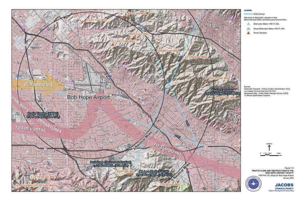
31 AIRSPACE AND PROCEDURES IN BOB HOPE AIRPORT AREA Airspace Structure The Class C airspace around has an irregular shape. The 10-NM radius area is truncated to the south where it abuts the LAX Class B airspace and to the east due to high terrain. The surface area has a cut-out to accommodate the operations at Whiteman Airport, 4 miles northwest of Bob Hope. The Class C Airspace extends from the surface to 4,800 feet MSL except for a portion to the northeast that extends from 3,500 feet MSL to 4,800 feet MSL due to high terrain. The airspace below the 3,500 feet MSL floor is Class D airspace. The 10-NM radius area extends from 3,000 feet MSL to 4,800 feet MSL. Below the floor of the Class C airspace and seven miles to the west is Van Nuys Airport. LAX lies 15 miles to the south and beyond the Santa Monica Mountains that rise to approximately 2,100 feet MSL Topography and Obstructions is in the eastern San Fernando Valley at the western edge of the San Gabriel Mountains. The airport elevation is 778 feet MSL with rapidly rising terrain to the north and the east. The terrain rises to 2,297 feet MSL in the Verdugo Mountains within three NM to the east, to over 4,000 feet MSL in the San Gabriel Mountains within 12 miles to the north and to 1,500 MSL at the eastern edge of the Santa Monica Mountains five miles south of the airport. Figure 7-6 shows the topography and obstructions in the area. While the mountains are the most important obstructions in the Airport area, several tall structures are within 5 NM of the Airport to the south and southwest. They rise to elevations ranging from 979 feet MSL to 2,043 feet MSL Approach and Departure Procedures at Precision Approach The primary precision approach in use today is the instrument landing system (ILS). An ILS provides an approach path for exact alignment to the landing runway, accompanied by descent guidance to accurately position the aircraft at the designated touchdown point on the runway. The system includes marer beacons or DME to indicate ey points along the approach path. The system is supplemented by approach lighting systems and runway lights. FAR Part 161 Application Chapter 7 Safe and Efficient Use of Navigable Airspace
32
NOTAM AIRCRAFT OWNERS AND PILOTS ASSOCIATION (AOPA) FLY-IN CHINO AIRPORT (CNO) CHINO, CALIFORNIA
 FLY-IN CHINO AIRPORT (CNO) CHINO, CALIFORNIA") NOTAM AIRCRAFT OWNERS AND PILOTS ASSOCIATION (AOPA) FLY-IN CHINO AIRPORT (CNO) CHINO, CALIFORNIA EFFECTIVE 12:00 NOON LOCAL FRIDAY, SEPTEMBER 19, 2014 UNTIL 6:00 PM LOCAL SATURDAY, SEPTEMBER 20, 2014 TEMPORARY
NOTAM AIRCRAFT OWNERS AND PILOTS ASSOCIATION (AOPA) FLY-IN CHINO AIRPORT (CNO) CHINO, CALIFORNIA EFFECTIVE 12:00 NOON LOCAL FRIDAY, SEPTEMBER 19, 2014 UNTIL 6:00 PM LOCAL SATURDAY, SEPTEMBER 20, 2014 TEMPORARY
rearranged (on same page)
") Airport/Facility Directory Southwest Current Edition: April 5 - May 31, 2012 deleted added rearranged (on same page) April 5 - May 31, 2012 February 9-9 April 5, April 5 - May 31, 2012 February 9-9 April
Airport/Facility Directory Southwest Current Edition: April 5 - May 31, 2012 deleted added rearranged (on same page) April 5 - May 31, 2012 February 9-9 April 5, April 5 - May 31, 2012 February 9-9 April
LA Basin Hot Spots. Southern California Airspace Users Working Group Education Subcommittee
 LA Basin Hot Spots This Presentation has been adapted from a presentation of Al German Orange County Flight Center by the Southern California Airspace Users Working Group Education Subcommittee What you
Noise-Based Use Restrictions
 Noise-Based Use Restrictions Presentation to: Noise Compatibility Committee October 26, 2017 Topics Legislative and regulatory background to noise restrictions Grandfathered Use Restrictions Airport initiatives
Appendix K: MSP Class B Airspace
 Appendix K: MSP Class B Airspace K All of the open sky covering the United States, from less than an inch off the ground all the way to outer space, is part of America s airspace. This airspace resource
1.1.3 Taxiways. Figure 1-15: Taxiway Data. DRAFT Inventory TYPICAL PAVEMENT CROSS-SECTION LIGHTING TYPE LENGTH (FEET) WIDTH (FEET) LIGHTING CONDITION
 WIDTH (FEET) LIGHTING CONDITION") 1.1.3 Taxiways EWN has an extensive network of taxiways and taxilanes connecting the terminal, air cargo, and general aviation areas with the runways as listed in Figure 1-15. A 50-foot wide parallel taxiway
1.1.3 Taxiways EWN has an extensive network of taxiways and taxilanes connecting the terminal, air cargo, and general aviation areas with the runways as listed in Figure 1-15. A 50-foot wide parallel taxiway
#1 Semi Valley VFR and Air Carrier Transitions : The area over Semi Valley that is another hotspot is where the Fernando 5 Arrival to Burbank brings j
 This slide identifies the 10 in-air HotSpots in the basin. The HotSpots are circled in red; and major commercial jet traffic routes are depicted by red lines with arrows. HotSpots 1, 10, 2, 3, and 4 are
Appendix B Ultimate Airport Capacity and Delay Simulation Modeling Analysis
 Appendix B ULTIMATE AIRPORT CAPACITY & DELAY SIMULATION MODELING ANALYSIS B TABLE OF CONTENTS EXHIBITS TABLES B.1 Introduction... 1 B.2 Simulation Modeling Assumption and Methodology... 4 B.2.1 Runway
The purpose of this Demand/Capacity. The airfield configuration for SPG. Methods for determining airport AIRPORT DEMAND CAPACITY. Runway Configuration
 Chapter 4 Page 65 AIRPORT DEMAND CAPACITY The purpose of this Demand/Capacity Analysis is to examine the capability of the Albert Whitted Airport (SPG) to meet the needs of its users. In doing so, this
CHAPTER 1 INTRODUCTION AND BACKGROUND
 CHAPTER 1 INTRODUCTION AND BACKGROUND An Environmental Assessment (EA) evaluates the effects of a proposed Federal action on the surrounding environment and is prepared in compliance with the National
Effective Altitude. R-3103 To 30,000 (To 9,144 meters) Source: NACO 2002 Notes: 1 By NOTAM issued 12 hours in advance
 Source: NACO 2002 Notes: 1 By NOTAM issued 12 hours in advance") 8.4 AIRSPACE USE 8.4.1 Affected Environment The affected airspace environment is described below in terms of its principal attributes, namely controlled and uncontrolled airspace, special use airspace,
8.4 AIRSPACE USE 8.4.1 Affected Environment The affected airspace environment is described below in terms of its principal attributes, namely controlled and uncontrolled airspace, special use airspace,
4.2 AIRSPACE. 4.2 Airspace. Supplemental Draft Environmental Impact Statement August 2008 Military Training Activities at Mākua Military Reservation
 4.2 AIRSPACE 4.2.1 Impact Methodology Impacts on airspace use were assessed by evaluating the potential effects of the proposed training activities on the principal attributes of airspace use, as described
Optimization of Airspace and Procedures in the Metroplex
 Optimization of Airspace and Procedures in the Metroplex Administration SoCal Metroplex Project Overview Brief To: By: Los Angeles World Airport Rob Henry, Manager SoCal Metroplex Jose Gonzalez, SoCal
Appendix C AIRPORT LAYOUT PLANS
 Appendix C AIRPORT LAYOUT PLANS Appendix C AIRPORT LAYOUT PLANS Airport Master Plan Santa Barbara Airport As part of this Airport Master Plan, the Federal Aviation Administration (FAA) requires the development
DO NOT BEGIN THIS WORK UNTIL YOU HAVE COMPLETED ALL REQUIRED ASSIGNED READING AND EXERCISES.
 DO NOT BEGIN THIS WORK UNTIL YOU HAVE COMPLETED ALL REQUIRED ASSIGNED READING AND EXERCISES. Gardner Textbook Review Questions to prepare for Class #12 Answer these on notebook paper (or a text file) then
Norman Y. Mineta San Jose International Airport Annual Noise Report
 Norman Y. Mineta San Jose International Airport 2015 Annual Noise Report Annual Noise Report for Norman Y. Mineta San José International Airport Introduction and Purpose The purpose of this annual report
LAX SPECIFIC PLAN AVIATION ACTIVITY ANALYSIS REPORT CY 2014
 LAX SPECIFIC PLAN AVIATION ACTIVITY ANALYSIS REPORT CY 2014 Prepared April 2015 Page 1 Los Angeles International Airport Specific Plan LAX Specific Plan Compliance Review Aviation Activity Analysis January
CATCODE ] CATCODE
![CATCODE ] CATCODE](/thumbs/82/85644630.jpg "CATCODE ] CATCODE") Runways. FAC: 1111 CATCODE: 111111 OPR: AFCEC/COS OCR: AF/A3O-A 1.1. Description. The runway is the paved surface provided for normal aircraft landings and take offs. Runways are classified as either Class
Runways. FAC: 1111 CATCODE: 111111 OPR: AFCEC/COS OCR: AF/A3O-A 1.1. Description. The runway is the paved surface provided for normal aircraft landings and take offs. Runways are classified as either Class
Pilot Information Packet
 Pilot Information Packet Including Special Flight Procedures Chino, CA September 20, 2014 Airworthy using the most detailed, historically accurate and talented restorationists in the world. Welcome to
APPENDIX F AIRSPACE INFORMATION
 APPENDIX F AIRSPACE INFORMATION Airspace Use DEFINITION OF AIRSPACE Airspace, or that space which lies above a nation and comes under its jurisdiction, is generally viewed as being unlimited. However,
Aviation Committee Meeting
 Aviation Committee Meeting Chair: Paul Haney (Englander Knabe & Allen) Vice Chairs: Jim Dunn (Airtel Plaza Hotel) Stacy Howard (National Business Aviation Association) Lunch Courtesy of WEDNESDAY, AUGUST
APPENDIX H 2022 BASELINE NOISE EXPOSURE CONTOUR
 APPENDIX H 2022 BASELINE NOISE EXPOSURE CONTOUR This appendix sets forth the detailed input data that was used to prepare noise exposure contours for 2022 Baseline conditions. H.1 DATA SOURCES AND ASSUMPTIONS
MetroAir Virtual Airlines
 MetroAir Virtual Airlines NAVIGATION BASICS V 1.0 NOT FOR REAL WORLD AVIATION GETTING STARTED 2 P a g e Having a good understanding of navigation is critical when you fly online the VATSIM network. ATC
Amendment of Restricted Areas R-2907A and R-2907B, Lake George, FL; and R-2910, Pinecastle, FL
 This document is scheduled to be published in the Federal Register on 07/03/2013 and available online at http://federalregister.gov/a/2013-16054, and on FDsys.gov 4910-13 DEPARTMENT OF TRANSPORTATION Federal
 IFR 91.157 Must be instrument rated to fly special VFR at Night (civil twilight to civil twilight, sun 6 degrees below horizon) 91.159 Unless in a holding pattern of 2 minutes or less, VFR cruising altitude
USE OF RADAR IN THE APPROACH CONTROL SERVICE
 USE OF RADAR IN THE APPROACH CONTROL SERVICE 1. Introduction The indications presented on the ATS surveillance system named radar may be used to perform the aerodrome, approach and en-route control service:
Source: Chippewa Valley Regional Airport ASOS, Period of Record
 Chapter 1 Inventory Runway wind coverage is the percentage of time a runway can be used without exceeding allowable crosswind velocities. Allowable crosswind velocities vary depending on aircraft size
SoCal Metroplex Study Area
 An Update on Southern California Airspace Modernization November 10, 2016 Chart Publication Date Long Beach Daugherty, John Wayne Orange County, Los Alamitos, Fullerton Municipal and Zamperini Field Airports
APPENDIX C AIRSPACE PROCEDURES
 APPENDIX C AIRSPACE PROCEDURES This appendix is designed to provide the reader with an introduction to how aircraft operate in and around Cincinnati/Northern Kentucky International Airport (CVG), the facilities
AIRSPACE STRUCTURE. In aeronautics, airspaces are the portion of the atmosphere controlled by a country above its territory.
 AIRSPACE STRUCTURE 1. Introduction In aeronautics, s are the portion of the atmosphere controlled by a country above its territory. There are two kinds of : Controlled is of defined dimensions within which
Chapter 9 - Airspace: The Wild Blue, Green & Red Yonder
 I5 Class G Airspace 38. [I4/3/3] What minimum visibility and clearance from clouds are required for VFR operations in Class G airspace at 700 feet AGL or lower during daylight hours? A. mile visibility
CHAPTER 1 EXECUTIVE SUMMARY
 CHAPTER 1 EXECUTIVE SUMMARY 1 1 EXECUTIVE SUMMARY INTRODUCTION William R. Fairchild International Airport (CLM) is located approximately three miles west of the city of Port Angeles, Washington. The airport
2. ROLES AND RESPONSIBILITIES.
 1. PURPOSE. This Standard Operating Procedure (SOP) outlines the procedures to be used by controllers working minor airports in ZLA to ensure that arrival and departure flows are handled in as efficient
Noise Abatement 101. July 13, Regular Board Meeting / August 7, 2014 Hillsborough County Aviation Authority
 Noise Abatement 101 July 13, 2017 1 Objectives Provide context and a better understanding for how and why flights may operate at Tampa International Airport the way they do. Provide an overview of laws,
FAA Requirements for Engine-out Procedures and Obstacle Clearance
 FAA Requirements for Engine-out Procedures and Obstacle Clearance Presentation to: CAAC Engine-out Procedures Seminar Name: Chuck Friesenhahn Date: 11/29/2005 Flight Standards Senior Advisor, Advanced
Norman Y. Mineta San José International Airport 2017 Annual Noise Report
 Norman Y. Mineta San José International Airport 2017 Annual Noise Report Annual Noise Report for Norman Y. Mineta San José International Airport Introduction and Purpose The purpose of this annual report
Re: Findings Regarding Possible Impacts of Proposed Rockfort Quarry on Aviation Activities at Brampton Airport
 Mr. Christopher J. Tzekas, Partner, WeirFoulds LLP, The Exchange Tower, Suite 1600, P.O. Box 480, 130 King Street West, Toronto, Ontario, M5X 1J5. May 8, 2010. Re: Findings Regarding Possible Impacts of
SOUTHERN CALIFORNIA TRACON STANDARD OPERATING PROCEDURES VIRTUAL AIR TRAFFIC SIMULATION NETWORK LOS ANGELES ARTCC
 SOUTHERN CALIFORNIA TRACON STANDARD OPERATING PROCEDURES VIRTUAL AIR TRAFFIC SIMULATION NETWORK LOS ANGELES ARTCC 1 SUBJ: Standard Operating Procedures VIRTUAL AIR TRAFFIC SIMULATION NETWORK LOS ANGELES
a. Aeronautical charts DID THIS IN LESSON 2
 AIRMAN CERTIFICATION STANDARDS: REMOTE PILOT SMALL: You will know and be able to explain in writing or oral form the below tasks regarding AIRPORT OPERATIONS Task References Objective Task B. Airport Operations
Table 5-15 Special Use Airspace in the SBMR Airspace ROI
 5.4 AIRSPACE 5.4.1 Affected Environment The affected airspace environment is described below in terms of its principal attributes, namely controlled and uncontrolled airspace, special use airspace, military
April 2011 Update- All things Aviation: If you d like additional information please contact the City. Noise 101
 April 2011 Update- All things Aviation: If you d like additional information please contact the City. Noise 101 As a result of last months meeting and numerous questions what follows is a brief discussion
The following criteria shall be applied within the boundaries of the AO District:
 Sec. 419 (a) Purpose AIRPORT OVERLAY DISTRICT (AO) The purpose of the Airport Overlay District is to regulate and restrict the height of structures, objects, or natural growth, regulate the locations of
This section sets forth all Los Angeles World Airports (LAWA) noise abatement procedures, restrictions, and regulations involving aircraft operations.
 noise abatement procedures, restrictions, and regulations involving aircraft operations.") This section sets forth all Los Angeles World Airports (LAWA) noise abatement procedures, restrictions, and regulations involving aircraft operations. 13.1. Aircraft Noise Abatement 13.1.1. All aircraft
This section sets forth all Los Angeles World Airports (LAWA) noise abatement procedures, restrictions, and regulations involving aircraft operations. 13.1. Aircraft Noise Abatement 13.1.1. All aircraft
CE 563 Airport Design
 CE 563 Airport Design Prevent aircraft collisions Prevent aircraft collisions with obstructions Expedite and maintain an orderly flow of air traffic Air traffic control system command center Herndon, VA
** DETERMINATION OF NO HAZARD TO AIR NAVIGATION **
 Mail Processing Center Federal Aviation Administration Southwest Regional Office Obstruction Evaluation Group 2601 Meacham Boulevard Fort Worth, TX 76137 Issued Date: 05/16/2011 Aeronautical Study No.
City Council Report. Mayor and City Council Susan Cline, Director, Public Works, Civil Engineering Subject: Airport Runway Shortening Options
 City Council Report To: From: Mayor and City Council Susan Cline, Director, Public Works, Civil Engineering Subject: Airport Runway Shortening Options City Council Meeting: May 24, 2017 Agenda Item: 8.A
FLASHCARDS AIRSPACE. Courtesy of the Air Safety Institute, a Division of the AOPA Foundation, and made possible by AOPA Holdings Company.
 AIRSPACE FLASHCARDS Courtesy of the Air Safety Institute, a Division of the AOPA Foundation, and made possible by AOPA Holdings Company. The Air Safety Institute is dedicated to making flying easier and
APPENDIX X: RUNWAY LENGTH ANALYSIS
 APPENDIX X: RUNWAY LENGTH ANALYSIS Purpose For this Airport Master Plan study, the FAA has requested a runway length analysis to be completed to current FAA AC 150/5325-4B, Runway Length Requirements for
H O M E C O M I N G. NOTAM Aircraft Owners and Pilots Association (AOPA) Fly-In Frederick Municipal Airport (FDK) Frederick, MD
 Fly-In Frederick Municipal Airport (FDK) Frederick, MD") F L Y - I N AOPA H O M E C O M I N G FREDERICK, MD NOTAM Aircraft Owners and Pilots Association (AOPA) Fly-In Frederick Municipal Airport (FDK) Frederick, MD SPECIAL FLIGHT PROCEDURES EFFECTIVE 1200 NOON
F L Y - I N AOPA H O M E C O M I N G FREDERICK, MD NOTAM Aircraft Owners and Pilots Association (AOPA) Fly-In Frederick Municipal Airport (FDK) Frederick, MD SPECIAL FLIGHT PROCEDURES EFFECTIVE 1200 NOON
STAFF REPORT. Airport Land Use Plan Consistency Review: Santa Barbara Airport Master Plan. MEETING DATE: November 19, 2015 AGENDA ITEM: 7D
 STAFF REPORT SUBJECT: Airport Land Use Plan Consistency Review: Santa Barbara Airport Master Plan MEETING DATE: AGENDA ITEM: 7D STAFF CONTACT: Peter Imhof, Andrew Orfila RECOMMENDATION: Adopt findings
SoCal Metroplex Study Area
 An Update on Southern California Airspace Modernization November 10, 2016 Chart Publication Date Santa Barbara Municipal Airport, Bob Hope Airport, Palm Springs International Airport, Ontario International
KVNY HIGH. Van Nuys Airport Van Nuys, California, United States
 Diagram #1: Van Nuys Abatement and Curfew Regulation Page 1 Aircraft Categories: A, B & C / All Runways p. 1 of 20 Diagram #2: Van Nuys Abatement and Curfew Regulation Page 2 p. 2 of 20 Diagram #3: Van
FORT LAUDERDALE-HOLLYWOOD INTERNATIONAL AIRPORT ENVIRONMENTAL IMPACT STATEMENT DRAFT
 D.3 RUNWAY LENGTH ANALYSIS Appendix D Purpose and Need THIS PAGE INTENTIONALLY LEFT BLANK Appendix D Purpose and Need APPENDIX D.3 AIRFIELD GEOMETRIC REQUIREMENTS This information provided in this appendix
US Airspace A History
 US Airspace A History The Federal airway system began in 1927, when the Department of Commerce acquired the transcontinental airway from the U.S. Postal Service. All airspace was uncontrolled, there were
PLAN Anoka County - Blaine Airport
 Reliever Airports: NOISE ABATEMENT PLAN Anoka County - Blaine Airport INTRODUCTION The noise abatement plan for the Anoka County-Blaine Airport was prepared in recognition of the need to make the airport
RENO-TAHOE INTERNATIONAL AIRPORT APRIL 2008 PASSENGER STATISTICS
 Inter-Office Memo Reno-Tahoe Airport Authority Date: June 5, 2008 To: Statistics Recipients From: Tom Medland, Director Air Service Business Development Subject: RENO-TAHOE INTERNATIONAL AIRPORT PASSENGER
Windmills & Airspace Can We Work Together?
 May 29, 2008 Windmills & Airspace Can We Work Together? J. Randolph Babbitt C O N F I D E N T I A L www.oliverwyman.com Windmills & Airspace Overview of Airspace Issues For Wind Turbine Sites The FAA s
Jeppesen Mobile FliteDeck VFR
 Airport Information CLEARWATER INTL (PIE) 10 Rwy9730 118.30 CTAF Location Name Fuel and Services Available Identifier Length of longest runway Frequency (public airports only) Airport Elevation 118.60
Runway Length Analysis Prescott Municipal Airport
 APPENDIX 2 Runway Length Analysis Prescott Municipal Airport May 11, 2009 Version 2 (draft) Table of Contents Introduction... 1-1 Section 1 Purpose & Need... 1-2 Section 2 Design Standards...1-3 Section
APPENDIX D FEDERAL AVIATION REGULATIONS, PART 77
 APPENDIX D FEDERAL AVIATION REGULATIONS, PART 77 Subparts A through C PART 77 - OBJECTS AFFECTING NAVIGABLE AIRSPACE Subpart A General 77.1 Scope. 77.2 Definition of terms. 77.3 Standards. 77.5 Kinds of
Chapter 6. Nonradar. Section 1. General DISTANCE
 12/10/15 JO 7110.65W Chapter 6. Nonradar Section 1. General 6 1 1. DISTANCE Use mileage based (DME and/or ATD) procedures and minima only when direct pilot/controller communications are maintained. FIG
KOAK HIGH. Metropolitan Oakland Intl Airport Oakland, California, United States
 NOISE ABATEMENT PROCEDURES by Whispertrack Diagram #1: North Field Abatement Procedures All Aircraft Categories / Runways: 10L, 10R, 28L, 28R & 33 p. 1 of 9 NOISE ABATEMENT PROCEDURES by Whispertrack Diagram
Intro to Small Unmanned Aircraft Systems & Recreational Drones
 Intro to Small Unmanned Aircraft Systems & Recreational Drones Controlled Airspace Controlled Airspace has defined dimensions within which Air Traffic Control (ATC) services are provided. The level of
SUMMARY: This action modifies Class E surface airspace and Class E airspace extending
 This document is scheduled to be published in the Federal Register on 10/29/2018 and available online at https://federalregister.gov/d/2018-23478, and on govinfo.gov [4910-13] DEPARTMENT OF TRANSPORTATION
The presentation was approximately 25 minutes The presentation is part of Working Group Meeting 3
 This is the presentation for the third Master Plan Update Working Group Meeting being conducted for the Ted Stevens Anchorage International Airport Master Plan Update. It was given on Thursday March 7
BFR WRITTEN TEST B - For IFR Pilots
 (61 Questions) (Review and study of the FARs noted in parentheses right after the question number is encouraged. This is an open book test!) 1. (91.3) Who is responsible for determining that the altimeter
SOUTHERN CALIFORNIA TRACON BURBANK AREA STANDARD OPERATING PROCEDURES VIRTUAL AIR TRAFFIC SIMULATION NETWORK LOS ANGELES ARTCC
 SOUTHERN CALIFORNIA TRACON BURBANK AREA STANDARD OPERATING PROCEDURES VIRTUAL AIR TRAFFIC SIMULATION NETWORK LOS ANGELES ARTCC 1 Table of Contents SECTION 1. GENERAL 3 1-1. PURPOSE 3 1-2. SCOPE OF RESPONSIBILITIES
VIRTUAL AIR TRAFFIC SIMULATION NETWORK UNITED STATES DIVISION. SUBJ: Phoenix (PHX) Air Traffic Control Tower (ATCT) Standard Operating Procedures
 Air Traffic Control Tower (ATCT) Standard Operating Procedures") VIRTUAL AIR TRAFFIC SIMULATION NETWORK UNITED STATES DIVISION ALBUQUERQUE ARTCC ORDER PHX ATCT v7110.1a Effective Date: Sept. 18, 2014 SUBJ: Phoenix (PHX) Air Traffic Control Tower (ATCT) Standard Operating
VIRTUAL AIR TRAFFIC SIMULATION NETWORK UNITED STATES DIVISION ALBUQUERQUE ARTCC ORDER PHX ATCT v7110.1a Effective Date: Sept. 18, 2014 SUBJ: Phoenix (PHX) Air Traffic Control Tower (ATCT) Standard Operating
Permanent Noise Monitoring Act Quarterly Operations Report
 Permanent Noise Monitoring Act 1st Quarter 2006 Prepared by: Noise Mitigation Programs Office Rhode Island Airport Corporation For further information, please contact: Helena S. Reid, 737-4000 ext. 297
AIRPORT NOISE AND CAPACITY ACT OF 1990
 AIRPORT NOISE AND CAPACITY ACT OF 1990 P. 479 AIRPORT NOISE AND CAPACITY ACT OF 1990 SEC. 9301. SHORT TITLE This subtitle may be cited as the Airport Noise and /Capacity Act of 1990. [49 U.S.C. App. 2151
SITE ELEVATION AMSL...Ground Elevation in feet AMSL STRUCTURE HEIGHT...Height Above Ground Level OVERALL HEIGHT AMSL...Total Overall Height AMSL
 ******************************************** * Federal Airways & Airspace * * Summary Report * ******************************************** File: User Assigned File Name Latitude: NAD83 Coordinate Longitude:
FRENCH VALLEY AIRPORT (F70) Sky Canyon Dr. Murrieta, CA. Phone: Riverside FAA FSDO Complaint Line: (951)
 Sky Canyon Dr. Murrieta, CA. Phone: Riverside FAA FSDO Complaint Line: (951)") FRENCH VALLEY AIRPORT (F70) 37600 Sky Canyon Dr. Murrieta, CA Phone: 951-600-7297 Riverside FAA FSDO Complaint Line: (951) 276-6701 Visit the F70 website for additional information regarding the airport
FRENCH VALLEY AIRPORT (F70) 37600 Sky Canyon Dr. Murrieta, CA Phone: 951-600-7297 Riverside FAA FSDO Complaint Line: (951) 276-6701 Visit the F70 website for additional information regarding the airport
Permanent Noise Monitoring Act Quarterly Operations Report
 Permanent Noise Monitoring Act Prepared by: For further information, please contact: Daniel Porter at 401-691-2419. TABLE OF CONTENTS Introduction...3 Permanent Noise Monitoring Act...3 Passenger Activity...4
Washington Dulles International Airport (IAD) Aircraft Noise Contour Map Update
 Aircraft Noise Contour Map Update") Washington Dulles International Airport (IAD) Aircraft Noise Contour Map Update Ultimate ASV, Runway Use and Flight Tracks 4th Working Group Briefing 8/13/18 Meeting Purpose Discuss Public Workshop input
Washington Dulles International Airport (IAD) Aircraft Noise Contour Map Update Ultimate ASV, Runway Use and Flight Tracks 4th Working Group Briefing 8/13/18 Meeting Purpose Discuss Public Workshop input
SUBJECT: 2016 ANNUAL NOISE REPORT DATE: April 18, 2017 INFORMATION
 CITY OF SAN JOSE CAPITAL OF SILICON VALLEY Memorandum TO: HONORABLE MAYOR AND CITY COUNCIL FROM: Kimberly J. Becker SUBJECT: 2016 ANNUAL NOISE REPORT DATE: April 18, 2017 Approved Date 11ts 11* INFORMATION
Draft Concept Alternatives Analysis for the Inaugural Airport Program September 2005
 Draft Concept Alternatives Analysis for the Inaugural Airport Program September 2005 Section 3 - Refinement of the Ultimate Airfield Concept Using the Base Concept identified in Section 2, IDOT re-examined
According to FAA Advisory Circular 150/5060-5, Airport Capacity and Delay, the elements that affect airfield capacity include:
 4.1 INTRODUCTION The previous chapters have described the existing facilities and provided planning guidelines as well as a forecast of demand for aviation activity at North Perry Airport. The demand/capacity
AUGUST 2008 MONTHLY PASSENGER AND CARGO STATISTICS
 Inter-Office Memo Reno-Tahoe Airport Authority Date: October 2, 2008 To: Statistics Recipients From: Tom Medland, Director Air Service Business Development Subject: RENO-TAHOE INTERNATIONAL AIRPORT PASSENGER
EXPLANATION OF TPP TERMS AND SYMBOLS
 U.S. TERMINAL PROCEDURES PUBLICATION 52 EXPLANATION OF TPP TERMS AND SYMBOLS The discussions and examples in this section will be based primarily on the IFR (Instrument Flight Rule) Terminal Procedures
Community Impact: Focus on Barston
 Community Impact: Focus on Barston With flights to more than 140 destinations worldwide and a workforce of more than 6,000 people, Birmingham is the UK s 7th largest airport and an economic powerhouse,
Las Vegas McCarran International Airport. Capacity Enhancement Plan
 Las Vegas McCarran International Airport Capacity Enhancement Plan Las Vegas McCarran International Airport Capacity Enhancement Plan September 1994 Prepared jointly by the U.S. Department of Transportation,
** DETERMINATION OF NO HAZARD TO AIR NAVIGATION **
 Mail Processing Center Federal Aviation Administration Southwest Regional Office Obstruction Evaluation Group 2601 Meacham Boulevard Fort Worth, TX 76137 Issued Date: 01/04/2012 Aeronautical Study No.
1.0 OUTLINE OF NOISE ANALYSIS...3
 Table of Contents 1.0 OUTLINE OF NOISE ANALYSIS...3 2.0 METHODOLOGY...3 2.1 BACKGROUND...3 2.2 COMPUTER MODELING...3 3.0 EXISTING NOISE ENVIRONMENT...4 3.1 EXISTING SANTA MONICA MUNICIPAL AIRPORT NOISE...4
AVIATION PLANNING AND DEVELOPMENT Oakland International Airport 530 Water Street Oakland, CA 94607
 AVIATION PLANNING AND DEVELOPMENT Oakland International Airport 530 Water Street When Do I Need to File an FAA Form 7460-1? Objects Affecting Navigable Airspace (14CFR77) June 2013 Background The Federal
Agenda: SASP SAC Meeting 3
 Agenda: SASP SAC Meeting 3 Date: 04/12/18 Public Involvement Plan Update Defining the System Recommended Classifications Discussion Break Review current system Outreach what we heard Proposed changes Classification
An Update on Southern California Airspace Modernization November 10, 2016 Chart Publication Date San Diego International, McClellan Palomar, Brown
 An Update on Southern California Airspace Modernization November 10, 2016 Chart Publication Date San Diego International, McClellan Palomar, Brown Field Municipal and Navy North Island Airports October
Inventory of Existing Conditions.
 A Inventory of Existing Conditions. Fort Collins-Loveland Municipal Airport, jointly owned and operated by the Cities of Fort Collins and Loveland, is located in the heart of a region with a thriving economy,
Required Navigation Performance at Alaska Airlines
 Required Navigation Performance at Alaska Airlines Sarah Dalton Director, Airspace and Technology Kotzebue Nome Barrow Prudhoe Bay Adak Bethel Dillingham Dutch King Salmon Fairbanks Anchorage Cordova Harbor
NAVIGATION: CHARTS, PUBLICATIONS, FLIGHT COMPUTERS (chapters 7 & 8)
") NAVIGATION: CHARTS, PUBLICATIONS, FLIGHT COMPUTERS (chapters 7 & 8) LONGITUDE AND LATITUDE 1. The location of an airport can be determined by the intersection of lines of latitude and longitude. a. Lines
NAVIGATION: CHARTS, PUBLICATIONS, FLIGHT COMPUTERS (chapters 7 & 8) LONGITUDE AND LATITUDE 1. The location of an airport can be determined by the intersection of lines of latitude and longitude. a. Lines
RULES OF TENNESSEE DEPARTMENT OF TRANSPORTATION AERONAUTICS DIVISION CHAPTER LICENSING AND REGISTRATION OF AIRPORTS TABLE OF CONTENTS
 RULES OF TENNESSEE DEPARTMENT OF TRANSPORTATION AERONAUTICS DIVISION CHAPTER 1680-1-2 LICENSING AND REGISTRATION OF AIRPORTS TABLE OF CONTENTS 1680-1-2-.01 Purpose 1680-1-2-.06 Repealed 1680-1-2-.02 Definitions
SOUTHERN CALIFORNIA TRACON LOS ANGELES AREA STANDARD OPERATING PROCEDURES VIRTUAL AIR TRAFFIC SIMULATION NETWORK LOS ANGELES ARTCC
 SOUTHERN CALIFORNIA TRACON LOS ANGELES AREA STANDARD OPERATING PROCEDURES VIRTUAL AIR TRAFFIC SIMULATION NETWORK LOS ANGELES ARTCC 1 Table of Contents SECTION 1. GENERAL 4 1-1. PURPOSE 4 1-2. SCOPE OF
NextGen: New Technology for Improved Noise Mitigation Efforts: DFW RNAV Departure Procedures
 NextGen: New Technology for Improved Noise Mitigation Efforts: DFW RNAV Departure Procedures DFW International Airport Sandy Lancaster, Manager Noise Compatibility October 13, 2008 OUTLINE About DFW Airport
TANZANIA CIVIL AVIATION AUTHORITY AIR NAVIGATION SERVICES INSPECTORATE. Title: CONSTRUCTION OF VISUAL AND INSTRUMENT FLIGHT PROCEDURES
 Page 1 of 8 1. PURPOSE 1.1. This Advisory Circular provides guidance to personnel involved in construction of instrument and visual flight procedures for publication in the Aeronautical Information Publication.
Runway and Taxiway Marking
 Lecture-38 10CV63 TE-II Runway and Taxiway Marking In order to aid pilots in guiding the aircraft on runways and taxiways, pavements are marked with lines and numbers. These markings are of benefit primarily
FACT SHEET Downtown Obstructions and Future Air Service for San José and Silicon Valley
 FACT SHEET Downtown Obstructions and Future Air Service for San José and Silicon Valley This year the San José City Council will attempt to balance two very important goals for the economy for San José
Permanent Noise Monitoring Act Quarterly Operations Report
 Permanent Noise Monitoring Act Quarterly Operations Report 1st Quarter 2010 Prepared by: Noise Mitigation Programs Office Rhode Island Airport Corporation For further information, please contact: Helena
Summary of Public Submissions Received on
 Summary of Public Submissions Received on NPRM 15-01 Omnibus 2014 Prepared by DENISE RATIETA and PAUL ELTON 17 August 2015 Table of Contents General... 1 Summary of Submissions... 1 Definition of controlled
Proposed Establishment of and Modification to Restricted Areas; Fort Sill, OK
 This document is scheduled to be published in the Federal Register on 10/19/2015 and available online at http://federalregister.gov/a/2015-26499, and on FDsys.gov 4910-13 DEPARTMENT OF TRANSPORTATION Federal
FUTENMA REPLACEMENT FACILITY BILATERAL EXPERTS STUDY GROUP REPORT. August 31, 2010
 FUTENMA REPLACEMENT FACILITY BILATERAL EXPERTS STUDY GROUP REPORT August 31, 2010 MANDATE AND SCOPE OF WORK: In order to achieve the earliest possible relocation of Marine Corps Air Station Futenma, the
PART 210 NOISE ABATEMENT AND RUNWAY PROCEDURES NOISE ABATEMENT AND PREFERENTIAL RUNWAY USE PROCEDURES
 PART 210 NOISE ABATEMENT AND RUNWAY PROCEDURES 210.01 NOISE ABATEMENT AND PREFERENTIAL RUNWAY USE PROCEDURES 210.01-1 Establishment Of Procedures; FAA Guidelines This Rule establishes preferential runway