Flagler s Middle Keys Connection. Recreation. Nature. History.
|
|
|
- Abigail Gaines
- 5 years ago
- Views:
Transcription
1 Flagler s Middle Keys Connection Recreation. Nature. History.
2
3 The University of Florida College of Design, Construction, and Planning Flagler s Middle Key s Connection A Landscape Architecture Undergraduate Thesis Project Andrew Dunn Faculty Advisor- Lester Linscott April 2012
4
5 Dedication- This project is dedicated to the future generations. May they acquire a passion and understanding for the cultural and natural history of the land. Acknowledgements- I would like to thank many people that have been there for me along the way. First and foremost my parents for introducing me to nature at an early age. The exposure to nature on family vacations has inspired me to pursue a career in a field I am passionate about. My classmates for always being there with an answer to a question and never turning down a good time. I would also like to thank the faculty for their constant guidance: Tina Gurucharri, Kevin Thompson, Bo Zhang, Les Linscott, Kay Williams, Glen Acomb, Chris Lathrop, Mary Padua and Gail Hansen.
6
7 Table of Contents- Chapter one Introduction...9 Chapter two Context Analysis...18 Chapter three Synthesis...29 Chapter four Concepts...34 Chapter five Master Plan...37 Chapter six Boot Key Wildlife Outpost...41 Chapter seven Sunset Park...49 Chapter eight Veterans Park...57 Chapter nine Overseas Park...65 References...72
8
9 Introduction Chapter 1 Chapter 1

10 Abstract The Middle Keys was once considered the largest feat to overcome in Henry Flagler s Overseas Railway. The area contains some of the prime examples of man s never ending quest to conquer nature. Some of the greatest engineering feats of the early 20th century are contained within my site. Also contained within my site and adjacent to my site are arguably some of the most unique ecosystems found within the Keys. The abundance of cultural history and ecologic diversity were the driving forces in choosing my site. Flagler s Middle Keys Connection creates a destination for residents and tourists of the Middle Keys. Located between Marathon, FL and Big Pine Key, FL, the site contains 8 historic bridges, Pigeon Key (historic island), Boot Key (Florida Forever Land), and is bordered by Florida Keys National Marine Sanctuary, Coupon Bight Aquatic Preserve, The National Key Deer Wildlife Refuge, and The Great White Heron National Wildflife Refuge. The abundance of natural and cultural history are a catalyst to create a premiere eco-tourism destination for the region. The linear site is also a missing link in the Florida Keys Overseas Heritage Trail that runs the 106 mile path from Key Largo to Key West. Another notable feature of the site is the Overseas Highway which was recently designated a National Scenic Highway. The program relies heavily on the development of the outdoor recreation opportunities associated with the Overseas Heritage Trail, but also includes the 1100 acre Boot Key which is currently in the acquisition stages for the Florida Forever Act. The recreation opportunities include but are not limited to: biking, jogging, hiking, fishing, kayaking, birding, camping, picnicking, swimming, snorkeling, scuba diving, paddle boarding, boating and auto touring. The site will offer various interpretive displays and supplement the existing Pigeon Key Overseas Railway Museum. 10
11 Overview Knights Key Marathon, FL Pigeon Key Big Pine Key, FL Little Duck Key Boot Key Scout Key Bahia Honda State Park Overview Located in between Marathon, FL and Big Pine Key, Fl in the Florida Keys. The site represents a missing link in the Florida Keys Overseas Heritage Trail. the project spans from Knights Key west southwest to Spanish Harbor Key. The linear site connects 8 islands, 4 of which will be designed within the parameters of the project. Two of the other four will be utilized only as connectors for the site to run through. The other two (Pigeon Key and Bahia Honda State Park) are existing attractions to the area that the project will connect to. The Site 13 miles long (approximately 8.5 miles span open ocean) Boot Key (approximately 1100 acres) Knights Key (approximately 25 acres) Little Duck Key (approx. 15 acres) Spanish Harbor Key (approx. 25 acres) 11


12 History The Overseas Railroad was the final piece of the puzzle to connect Henry Flagler s Florida East Coast Railway to Key West. In the late 19th century and early 20th century Key West was the largest city in Florida despite it being only accessible by water. The water access was what made Key West a significant port for the United States to trade with the Caribbean. This was the main reason Flagler decided to extend the railroad to Key West. With the opening of the Panama Canal there were great plans for Key West to become the largest port on the East Coast. Two of the greatest engineering feats of the Overseas Railway are the Seven Mile Bridge and the Bahia Honda Bridge both of which are within the boundaries of my site. The old seven mile bridge, once considered the 8th wonder of the world, was for some time the longest bridge in the world and the first of its magnitude. Bahia Honda is another unique bridge due to the fact that it was the only steel truss span, and that it had to cross the deepest channel in the Florida Keys. The amount of cultural history involved with the historic railway in itself creates a destination for history seekers. Seven Mile Bridge Bahia Honda Bridge 12

13 Tourism Ft. Lauderdale Tourism Flow Tourism drives the economy of the Florida Keys.The majority of the visitors to my site will be traveling by car on their way south to Key West. Miami Florida s Turnpike and I-95 are the main routes people travel on their way south to the Florida Keys. Once they reach homestead they travel through 18 miles through the Everglades before arriving in Key Largo. Miami international airport and Ft. Lauderdale international airport are major portals for the tourism industry in south florida. However some visitors fly into Marathon or Key West airports. An even smaller number of visitors arrive via cruise ship. In the latter case these visitors normally don t leave Key West. Fortunately the only route to Key West runs directly through my site and will force visitors to at least view if not stop and enjoy it. Key Largo Islamorada Key West Marathon 13
14 Issues Florida Keys Overseas Heritage Trail is a multi-use trail that is currently in the construction phase. Area s surrounding the famous bridges lack infrastructure and program. Connectivity between these sites is very limited. Historic bridges are being closed from pedestrian access due to structural safety issues. Conservation lands are in the proccess of being acquired under the Florida Forever Land Act. 14


15 FKOHT The Florida Keys Overseas Heritage Trail (FKOHT) traverses 106 miles from Key Largo to Key West along the path of the overseas highway. The goal of the trail is to connect the different communities throughout the Florida Keys and provide a non-motorized form of transportation while promoting various forms of outdoor recreation. In its current stage the trail is contiguous throughout the Upper Keys, but becomes severely disconnected at the east entrance to my site. Users of the trail are forced to ride or walk on the shoulder of the new Seven Mile Bridge. This is accepted by many of the long distance cyclists, but becomes a major deterrent for the family oriented and/or less skilled cyclist. The trail also promotes other forms of recreation such as kayaking and bridge fishing. Many kayak launching sites are located along the trail. View of the Overseas Heritage Trail at Sunset Park. 15
16 Historic Bridges Bridges owned by FDOT or FDEP. Three different styles of bridge are relative to the depth of the water they are in. In the 1940 s the bridges were repurposed to accomodated automobile traffic. Original surface deck was expanded from 12 to 22 to accomodate the two lane Overseas Highway. On several of the historic bridges the expanded road bed has badly deteriorated. FDOT has been removing sections of bridges to prevent pedestrian access to these unsafe bridges. In several cases bridges have been restored to the original 12 rail deck and repurposed as fishing piers. Many of these bridges could be key components in connecting the FKOHT through this area. 16
17
18 Context Analysis Chapter two
19 Context Distances to: Orlando-350 miles Miami- 118 miles Key Largo- 54 miles Marathon- 4.3 miles Key West miles Orlando Proposed Site Marathon Miami Big Pine Key Key Largo Key West 19
20 Scenic Highway Overseas Highway Popular Views The Overseas Highway is the only vehicular access to the Florida Keys. This route stretches from North Key Largo 106 miles south and ends in Key West. Recently it was designated as a National Scenic Highway. Fortunately the location of my parks maximizes exposure to toursists that are traveling along the road. Arguably some of the best views on the 106 mile route can be found within my site, notably the Seven Mile Bridge and Bahia Honda Bridge. 20
21 FKOHT Project Sites Existing FKOHT trails Proposed FKOHT trails Retrofitted Bridge Bridge Restoration The Florida Keys Overseas Heritage Trail is a multi-use corridor that is intended to connect the different communities and attractions within the Keys. Unfortunately there is a lack of overall connection between my sites and much improvement could be done to provide and alternate mode of transportation. Retrofitting of bridges could provide safe alternate routes to cyclists or pedestrians who do not wish to ride on the shoulder of some of the bridges in the area. Creating catwalks that cantilever off of the existing road structure could provide an alternate mode for safe transportation of the trail route. 21
22 Attractions Crane Point Museum Pigeon Key Historic Site Seven Mile Bridge Sombrero Beach Bahia Honda State Park Wildlife Refuge Attractions State Park National Key Deer Wildlife Refuge The surrounding area offers various recreation opportunities most of which are water based activities. Among the leading opportunities are fishing (from land, bridge or boat,) birding, cycling, and kayaking just to name a few. The opportunity and space to enjoy these activities is present, but the infrastructure and accessibility is seriously lacking. Almost every opportunity relies on the abundance of natural and cultural resources. 22
23 Historic Sites 12 Structures on the National Register of Historic Places tarpon migration pattern Historic Rest Stop Pigeon Key Historic Site Sand Key Lighthouse 24 Structures on the National Register of Historic Places tarpon migration pattern Reef Proposed Site Historic Bridges Bridge Break NRHP Site Historic Structure Historic Rest Stop Located in the immediate context are several historic sites of great significance. Many of these sites are directly related to the early 1900 s and the development of the Overseas Railway. There are 8 Flagler era historic bridges located in between my sites as well as numerous others in the immediate context. Among the other features are several sites that are listed on the National Register of Historic places as well as historic rest stops that were associated with the early Overseas Highway. 23
24 Fishing Fishing Hotspot Edge of Reef Sombrero Reef Offshore Fishing Marina Public Fishing Pier Atlantic Flyway Mississippi Flyway Arguably the largest industry in the Florida Keys is fishing. Fortunately some of the best fishing found in the keys is located in and around my site. Accessibility to fishing by the public has recently been addressed by the retrofitting of historic bridges into fishing piers, but much more work could be done to maximize this opportunity. The various marina s as well as guide services in the area provide opportunities for people who have the time and money to get out and explore what the area has to offer. 24
25 Birding Crane Point Museum and Nature Center Blue Hole & The Jack Watson and Fred Manillo Trails Bahia Honda State Park Great Florida Birding Trail Site Falcon Hotspot Wading Bird Area An activity that has gained popularity in recent years is birding. This area has an abundance of opportunities for users to get out and experience some of the best birding found in the Florida Keys. 25

26 Land Use Surrounding land use (West of site): The surrounding land use in the Big Pine Key area is primarily single family residential with commercial uses along the highway. Big Pine Key and the islands to the north are included in the Wildlife Key Deer Refuge and The Great White Heron National Wildlife Refuge. 26

27 Land Use Surrounding land use (East of site): The surrounding land use in the Marathon area consists of commercial along the highway with single family residential neighborhoods on the waterfront. Marathon has a small airport as well as other amenities found in small cities. 27
28
29 Synthesis Chapter three
30 Project Goals Maximize outdoor recreation opportunities Program areas for optimum uses Expand the recreation opportunities passed the shoreline Include all potential user groups Preserve and enhance the historic and natural integrity of site Retrofit historic structures for re-use Utilize low impact design to preserve sensitive ecosystems Interpret the landscape to educate the users Provide a stimulus to the local economy Allow concessionaires to lease space on specific sites Create a destination that draws tourists and keeps tourists in the area 30

31 Program Land Based Recreation Sight Seeing Birding Cycling Jogging Camping Picnics Sunbathing Water Based Recreation Boating Fishing Eco-tours Ferry rides Kayaking Paddleboarding Swimming Snorkeling Conservation Wildlife Areas Seagrass Restoration Artificial Reefs Education Marine Biology Ecology Natural History Cultural History 31
32 Synthesis Spanish Harbor Opportunity Constraint Deep water access Poor Access (car) Scenic Views steep topo Connect with SP Large area Veterans Memorial Park Opportunity Pristine Beach Scenic Views Existing Chickees Historic Structure Terminus of 7 mile Boat Ramp Constraint Limited Space U.S. 1 divides Seven Mile and Bahia Honda Bridges Opportunity FKOHT connectivity Bridge fishing multi-use corridor Constraint Limited Space expensive retrofit Opportunity Pristine Ecosystems Existing Structures Birding Education Center Zoned for Building Boot Key Knights Key Opportunity Terminus of 7 mile Historic Structure FKOHT connection Great Fishing Historic Value Constraint Garbage/Litter No Access (car) Sensitive ecosystems Constraint Limited Space Space under bridge Conflicting users Steep Topo The site has numerous opportunities to accomodate a more structured programming for nature based recreation. The amount of tourists that travel by these sites is the greatest opportunity. I intend to provide activities for tourists to stay in the area instead of stop in and continue south on their way to Key West. 32
33
34 Concepts Chapter four

35 Concepts Concept 1- The History of Land Travel -Connect the Florida Keys Overseas Heritage Trail through the historic bridges -Trail will serve as a contiguous multi-use linear park connecting Marathon and Big Pine -Create Hubs at Knights Key and Spanish Harbor to serve as museums and welcome centers -Create Rest Stop at Veterans Memorial Park -Leave Boot Key as an example of inefficient land travel and allow for the island to revert back to its natural state. Concept 3- Maximize Economic Benefit -Combine both concepts to provide a diverse experience and accomodate more users -Win, Win, Win Concept 2- Native Transportation -Maintain the bridges only as monuments of ingenuity -Provide ferries for users to experience what life was like before the railroad -Maximize accessibility for kayakers and other water born activities -Promote marine based environmental education -Expand the site to provide primitive camping experiences -Utilize Boot Key as a wildlife outpost 35
36
37 Master Plan Chapter five


38 Master Sunset Park Marathon Big Pine Key Veterans Park Boot Key Outpost Overseas Park 38
39 Connections Ferry Dock Ferry Route Public Boat Ramp Kayak Launch Marine access to the sites is a key component to connectivity of the different areas. Providing a ferry service that connects the sites gives users insight as to what transportation was like prior to the Overseas Railway. It also provides a great opportunity for people to get out on the water and experience something that most are not accustomed to. 39
40
41 Boot Key Chapter six

42 Context Marathon Seven Mile Bridge Big Pine Key Conditions Boot Key Outpost Site details: 1100 acres Being acquired by the Florida Forever Land Act Variety of outdoor experiences available Unique eco systems 42


43 43 Analysis
44 Conditions


45 Ecosystems Saltwater Lakes and Creeks Mangroves Rockland Hammock Boot Key Ecosystems Coastal Dune Disturbed Soils 45

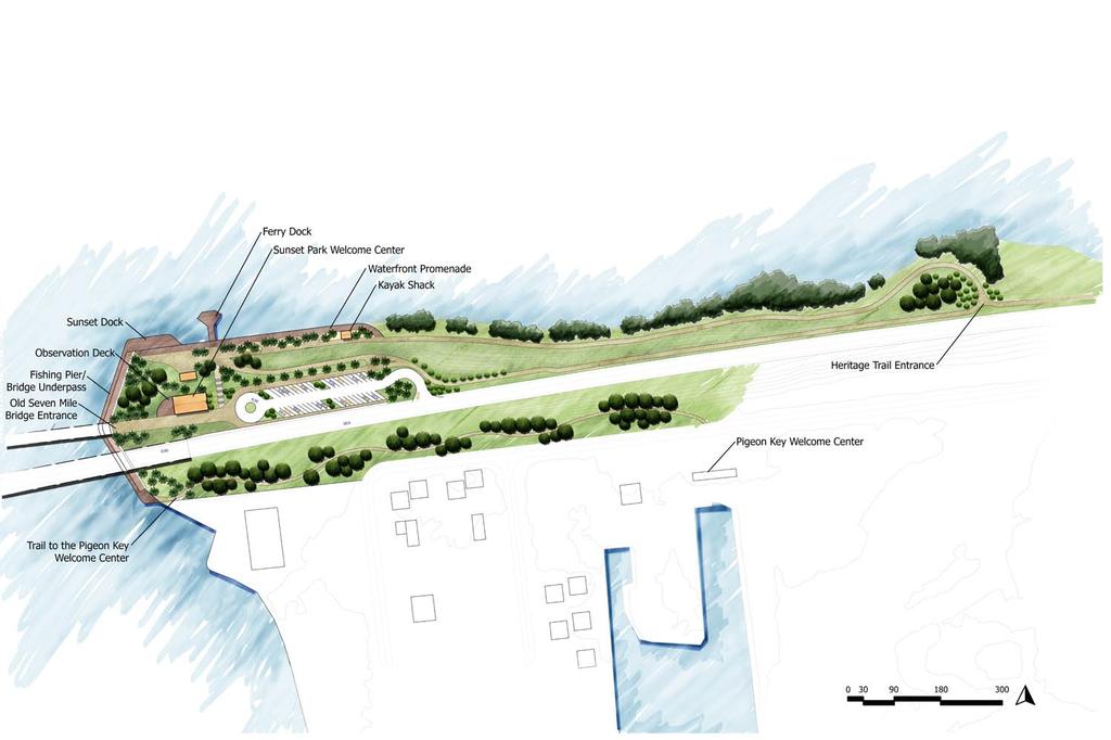
46 Site Plan 46

47 Experience Boot Key offers a great wilderness experience without the long distance paddling involved. Users can choose from a variety of camping experiences. This perspective depicts a typical platform camping experience where kayakers can paddle up tie off there kayaks and stay for the night. 47
48
49 Sunset Park Chapter seven

50 Context Marathon Big Pine Key Sunset Park Site Details: Located at the west end of the 7 mile bridge Provides access for Pigeon Key Lacks program and infrastructure 50

51 Existing

52 Analysis HP Slopes >20% Historic Structure Entrance to 7 mile Bridge Good Views Existing Trail Overseas Highway Access Barrier Parking Entrance 52
53 53 Master
54 Museum stairs Sunset Park Welcome Center provides natural and cultural exhibits and has a stairway that links the parking area and museum to the waterfront and ferry dock. 54

55 Fishing Pier Sunset Park fishing pier and multi-use underpass connects the north and south sides of the park while alleviating the conflicting uses between fisherman and pedestrians. 55
56
57 Veterans Park Chapter eight
58 Context Marathon Big Pine Key Veterans Park Site Details: Located at the west end of the 7 mile bridge Minimal existing infrastructure Popular beach area 58
59 Existing

60 Analysis 60
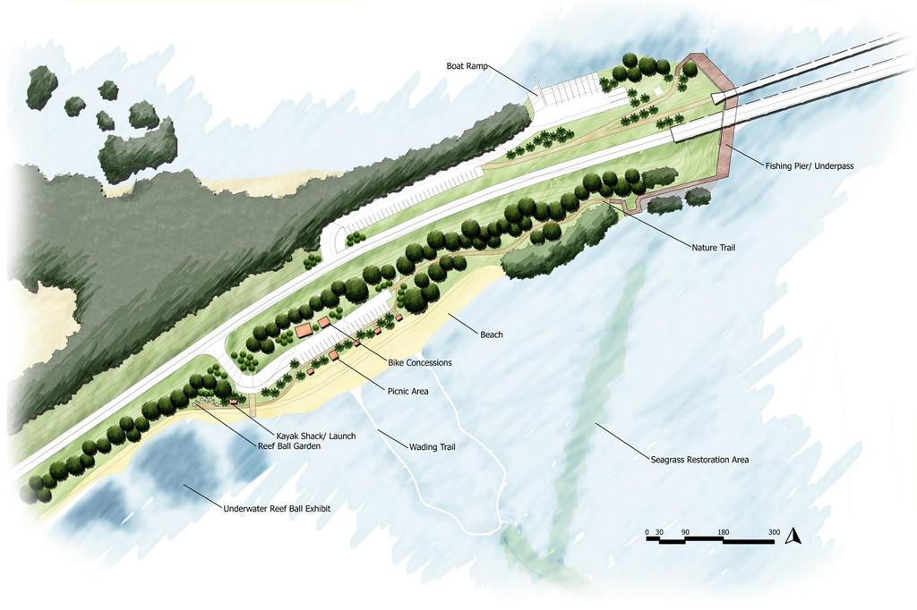
61 61 Master

62 Interpretive Trail Pacet Viaduct underpass provides access to the north and south portion of the site as well as an interpretive experience into a new type of historic bridge architecture. 62

63 Reef Ball Garden The reef ball garden at Veterans Park gives users an opportunity to learn about artificial reefs on land as well as opportunities to view them in the adjacent protected waters. 63
64
65 Overseas Park Chapter nine

66 Context Marathon Big Pine Key Overseas Park Site Details: Located at the west end of the historic Bahia Honda Bridge Abandoned historic park 25 Acres 66

67 Analysis HP Slopes >20% Good Views Historic Structure Bahia Honda Bridge 0 Parking Entrance Overseas Highway Historic Rail Path Unsafe to access 67
68 Existing
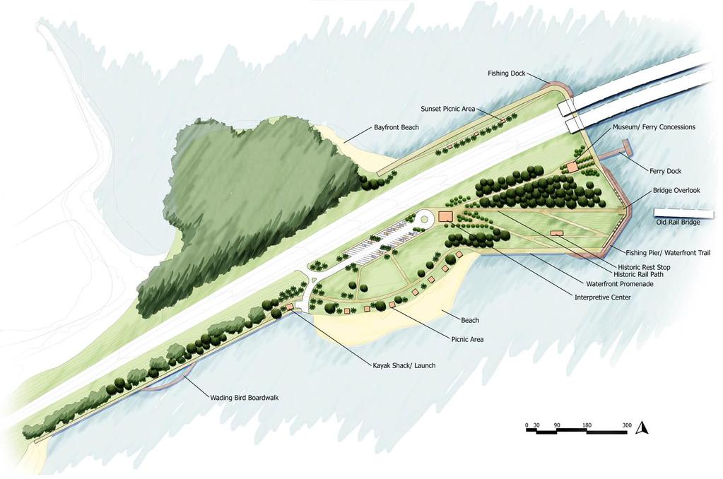
69 69 Master

70 Interpretative Trail Overseas Park interpretive trail educates users about the path of the railway through the site and gives information to ease navigation to the different areas of the site. 70
71
72 References
73 References Featured BirdYellow Rail. Homepage. 12 Jan < Florida Department of State. û Home Page. 27 Apr < Florida Keys History Museum. Florida Keys History Museum. 27 Apr < Florida Keys Scenic Highway. America s Byways : National Scenic Byways Online. 12 Apr < Gallagher, Dan. Florida s Great Ocean Railway: Building the Key West extension. Sarasota, FL: Pineapple P, Gallagher, Dan. The Florida Keys environmental story: A panorama of the environment, culture and history of Monroe County, Florida. [Big Pine Key, FL]: Seacamp Association, Great White Heron NWR. U.S. Fish and Wildlife Service Home. 1 Apr < History. Florida East Coast Railway. 3 Mar < Monroe County, FL - Official Website. Monroe County, FL. 1 Apr < North American Migration Flyways. The Nutty Birdwatcher. 7 Feb < Trail is newest legacy of FlaglerÂs railroad. Trail is newest legacy of FlaglerÂs railroad. 10 Jan < com/2009/07/05/117984/trail-is-newest-legacy-of-flaglers.html>. Trail is newest legacy of FlaglerÂs railroad. Trail is newest legacy of FlaglerÂs railroad. 10 Nov < com/2009/07/05/117984/trail-is-newest-legacy-of-flaglers.html>. Welcome Florida Department of Environmental Protection (DEP). Welcome. 3 Jan < Welcome. The International Ecotourism Society. 27 Mar < Welcome to Florida State Parks. Welcome to Florida State Parks. 10 Feb < Zeiller, Warren. The Florida Keys overseas railway. Berkeley and Wilton, CA: Signature P, 2006.
Header i
 Header i 048285014.10 Header Sub Title Body Text here. Body text here. Body text here. Section 1... 1 Executive Summary... 1 Opportunities and Constraints... 3 Overall Opportunities and Constraints Map
2. Goals and Policies. The following are the adopted Parks and Trails Goals for Stillwater Township:
 D. PARKS AND TRAILS 1. Introduction Stillwater Township s population is relatively low, with most residents living on rural residences on large lots. The need for active park space has been minimal in
Acquisition in fee simple of approximately one-half acre of property on the shore of Spring Lake to expand the Lakeside Beach Park.
 Lakeside Beach TF00-136 $122,550.00 in fee simple of approximately one-half acre of property on the shore of Spring Lake to exp the Lakeside Beach. 2000 River Ravines TF00-150 $910,000.00 in fee simple
Pinellas County Environmental Lands
 Pinellas County Environmental Lands In addition to traditional parks and recreation facilities, Pinellas County owns and manages a system of environmental lands that provides specialized resource-based
I* I9 ². F l o r i d a C i r c u m n a v i g a t i o n a l S a l t w a t e r P a d d l i n g T r a i l S e g m e n t 1 5
 M M 1 0 4-8 9 F l o r i d a C i r c u m n a v i g a t i o n a l S a l t w a t e r P a d d l i n g T r a i l S e g m e n t 1 5 F l o r i d a K e y s O v e r s e a s P a d d l i n g T r a i l M M 7 1-5 9
Flow Stand Up Paddle Board Parkway Plan Analysis
 Regional Parks Department Jeffrey R. Leatherman, Director County of Sacramento Divisions Administration Golf Leisure Services Maintenance Rangers Therapeutic Recreation Services Flow Stand Up Paddle Board
Segment 2: La Crescent to Miller s Corner
 goal of the USFWS refuges is to conserve, protect and enhance fish, wildlife and plants and their habitats for the continuing benefit of the American people. Refuge lands are used largely for fishing,
DRAFT - APRIL 13, 2007 ROUTING STUDY FOR TRAIL CONNECTIONS BETWEEN CALAIS AND AYERS JUNCTION
 DRAFT - APRIL 13, 2007 ROUTING STUDY FOR TRAIL CONNECTIONS BETWEEN CALAIS AND AYERS JUNCTION Abstract The vision for the East Coast Greenway is an off-road urban trail system running from Calais, Maine
City of Haslett. City of East Lansing. City of East Lansing
 Central Park North (Nancy L. Moore Park) Lake Park North Expansion White Park Expansion #2 White Park Expansion #1 County East East Haslett East East TF87-212 Acquisition $90,000.00 Park. TF08-138 Acquisition
Florida Keys Challenge
 Florida Keys Challenge January 9-15, 2017 Start: Curry Hammock State Park End: Zachary Taylor State Park in Key West Total Distance: 65 miles Registration Deadline: December 26, 2016 Trip Fee: $800. Includes
Hours of Operation. Bistro featuring Starbucks. Bluewater Poolside Bar. Infinity Pool. Fitness and Laundry. The Market. Open daily for breakfast
 Hours of Operation Bistro featuring Starbucks Open daily for breakfast Monday Friday 6:30 am 10:30 am Saturday Sunday 7:00 am 10:30 am Open daily for dinner 5:00 pm 10:00 pm Bluewater Poolside Bar Open
Florida s Most Remarkable Beach Resort. Jacoby D E V E L O P M E N T
 Florida s Most Remarkable Beach Resort Jacoby D E V E L O P M E N T Florida s Most Remarkable Beach Resort The World s First Oceanarium Built in 1938 as Marine Studios, an underwater motion picture studio
FEASIBILITY CRITERIA
 This chapter describes the methodology and criteria used to evaluate the feasibility of developing trails throughout the study areas. Land availability, habitat sensitivity, roadway crossings and on-street
AGENDA ITEM 5 D WAKULLA ENVIRONMENTAL INSTITUTE (WEI) TRAIL FEASIBILITY STUDY
 TRAIL FEASIBILITY STUDY") March 19, 2018 AGENDA ITEM 5 D WAKULLA ENVIRONMENTAL INSTITUTE (WEI) TRAIL FEASIBILITY STUDY TYPE OF ITEM: Action STATEMENT OF ISSUE The Wakulla Environmental Institute (WEI) Trail is one of several trails
March 19, 2018 AGENDA ITEM 5 D WAKULLA ENVIRONMENTAL INSTITUTE (WEI) TRAIL FEASIBILITY STUDY TYPE OF ITEM: Action STATEMENT OF ISSUE The Wakulla Environmental Institute (WEI) Trail is one of several trails
Welcome to the Cross County Trail Public Input Session!
 Welcome to the Cross County Trail Public Input Session! Please sign in on the table below! What are we doing here? Camden County has proposed a bicycle and pedestrian trail spanning across the entire county.
Explore the Bay Islands of Honduras
 Seacology SEACOLOGY Explore the Bay Islands of Honduras APRIL 8 15, 2018 Join Seacology in the Caribbean paradise of Roatán and Guanaja for a week of diving or snorkeling, and an in-depth look at Seacology
Unit 1 Lesson 1: Introduction to the Dry Tortugas and Sustainable Seas Expedition
 Unit 1 Lesson 1: Introduction to the Dry Tortugas and Sustainable Seas Expedition Lesson Objectives: Introduce students to the historical, geographic, and ecological importance of the Dry Tortugas. Introduce
Design Charrette Public Meeting
 Design Charrette Public Meeting Citizen Advisory Committee Members of the Public November 2, 2011 - Theodore Wirth Chalet - 6:30-8:30 p.m. Park Background: Visitation Estimation 2010 Regional Visitation
Welcome to Marco Island
 Marco Island is located in Southwest Florida, on the Gulf of Mexico, 178 miles south of Tampa,16 miles south of Naples, and 104 miles due west of Miami. Marco is the northern most and largest of the famous
At the time, the portion of the line through Eagle County remains wholly under the ownership of Union Pacific Railroad (UP).
.") Chapter 5 The Railroad Corridor as a Trail Corridor The intent of this chapter is to identify how the rail corridor, if available for lease or purchase in all or part, could be incorporated into the core
Chapter 5 The Railroad Corridor as a Trail Corridor The intent of this chapter is to identify how the rail corridor, if available for lease or purchase in all or part, could be incorporated into the core
1. Overview of Atlantic Highlands and Its Waterfront
 Atlantic Highlands 1. Overview of Atlantic Highlands and Its Waterfront Atlantic Highlands: Satellite Photo by USGS 1.1. Geographical Overview The Borough of Atlantic Highlands is on Sandy Hook Bay. It
MASTER PLAN EXECUTIVE SUMMARY
 Biscuit Run State Park Scottsville Road (State Route 20) Charlottesville, VA 22902 Biscuit Run State Park MASTER PLAN EXECUTIVE SUMMARY Department of Conservation and Recreation Division of Planning and
Waterfront Concept Plan: Community Survey Summary
 Waterfront Concept Plan: Community Survey Summary Published April 20, 2016 #1100085 Introduction The survey was one component of the public consultation process endorsed by Council in October, 2015. This
Proposal to Redevelop Lower Kananaskis River-Barrier Lake. Bow Valley Provincial Park
 Frequently Asked Questions Proposal to Redevelop Lower Kananaskis River-Barrier Lake Bow Valley Provincial Park Frequently Asked Questions What has been decided? What are the details of the plan? What
RIVER ACCESS STRATEGY
 RIVER ACCESS STRATEGY The River Access Strategy is a 10-year plan the City of Edmonton is developing to inform future programming, operations and infrastructure improvements that support access to the
FLORIDA DEPARTMENT OF ENVIRONMENTAL PROTECTION DIVISION OF RECREATION AND PARKS RECREATIONAL CARRYING CAPACITY GUIDELINES
 FLORIDA DEPARTMENT OF ENVIRONMENTAL PROTECTION DIVISION OF RECREATION AND PARKS RECREATIONAL CARRYING CAPACITY GUIDELINES THE SELECTION AND CAPACITY DETERMINATION OF USE SITES Introduction The Division
Classifications, Inventory and Level of Service
 Classifications, Inventory and Level of Service Section 3 Kenmore Park, Recreation and Open Space Plan 1 P a g e Classifications and Inventory Park Classifications Kenmore classifies its parks based upon
Proposal to Redevelop Lower Kananaskis River-Barrier Lake. Bow Valley Provincial Park. Frequently Asked Questions
 Proposal to Redevelop Lower Kananaskis River-Barrier Lake Bow Valley Provincial Park Frequently Asked Questions What is being proposed? What are the details of the proposal? Where is the project area located?
From To Florida 2019
 From To Florida 2019 From Space to Sea Outline The From Space to Sea tour is based in Florida, USA and takes place in the first two weeks of the mid-year break, 24 May 2019 to 6 June 2019. The trip is
Chapter 6. Trail Design. Trail Design
 Chapter 6 Trail Design Trail Design The trail winds through a region rich in scenic beauty, cultural, and natural history. Volunteer landscape architects working with the Core and Planning Teams, have
Port Gamble Shoreline Area Conceptual Trail Proposal
 The North Kitsap Trails Association is pleased to be a partner to the Kitsap Forest and Bay Project and assist Kitsap County, Forterra, Olympic Property Group, Great Peninsula Conservancy and the Port
Capital City to Sea Trail (CC2ST) SUMMARY
 SUMMARY") Capital City to Sea Trail (CC2ST) So far over $24M have been invested into the Capital City to Sea Trails. o $9M-Capital Region Transportation Planning Agency (CRTPA). Master Plan/Coastal Trail (Lighthouse
Capital City to Sea Trail (CC2ST) So far over $24M have been invested into the Capital City to Sea Trails. o $9M-Capital Region Transportation Planning Agency (CRTPA). Master Plan/Coastal Trail (Lighthouse
SouthwestFloridaInternational Airport
 SouthwestFloridaInternational Airport SouthwestFloridaInternationalAirportislocatedinLee CountyalongtheGulfCoastofSouthFlorida,tenmiles southeastofthefortmyerscentralbusinessdistrict. Theprimaryhighwayaccesstotheairportfrom
Dufferin Jog Elimination Project
 Project Project Status Update November 14 2007 Project History Planning Alternatives Criteria Measured Project Benefits Structural Configurations Considered Structural Design Considerations The Preferred
Airport Planning Area
 PLANNING AREA POLICIES l AIRPORT Airport Planning Area LOCATION AND CONTEXT The Airport Planning Area ( Airport area ) is a key part of Boise s economy and transportation network; it features a multi-purpose
THAT the Board approve the final proposed concept plan for the Jericho Marginal Wharf site as shown in Figure C-4 of Appendix C.
 Date: January 17, 2012 TO: Board Members Vancouver Park Board FROM: General Manager Parks and Recreation SUBJECT: Jericho Marginal Wharf Phase 2 Concept Plan RECOMMENDATION THAT the Board approve the final
Georgetown-Lewes Rail/Trail Study. Rail/Trail Study: Cool Spring to Cape Henlopen State Park New Road Extension (House Resolution No.
 Georgetown-Lewes Rail/Trail Study Rail/Trail Study: Cool Spring to Cape Henlopen State Park New Road Extension (House Resolution No. 47) August 22, 2011 Presentation Outline Background Benefits Statewide
4.0 Context for the Crossing Project
 4.0 Context for the Crossing Project This section provides background information about key features of the North Douglas Crossing project area, and opportunities and constraints. This information is important
Waterway Access and the Atlantic Intracoastal Waterway in Florida
 Waterway Access and the Atlantic Intracoastal Waterway in Florida Issues: Maintenance - Funding (costs), Infrastructure needs, permitting Management Consideration of the M-95 system, Cooperation among
Jefferson County Non-Motorized Transportation and Recreational Trails Plan 2010
 Chapter 8: Goals and objectives Plan Update: The following update presents general principles, goals, and objectives related to non-motorized transportation facilities as a component of the overall transportation
Clearwater Lake Provincial Park. Draft Management Plan
 Clearwater Lake Provincial Park Draft Management Plan Clearwater Lake Provincial Park Draft Management Plan Table of Contents 1. Introduction... 3 2. Park History... 4 3. Park Attributes... 4 3.1 Location/Access...4
2016 Regional Transportation Alternatives Program (TAP) Grant Application
 Grant Application") 2016 Regional Transportation Alternatives Program (TAP) Grant Application PROJECT TITLE: Yelm-Tenino Trail Extension Feasibility Study TRPC use only GENERAL PROJECT INFORMATION Agency or Organization City
2016 Regional Transportation Alternatives Program (TAP) Grant Application PROJECT TITLE: Yelm-Tenino Trail Extension Feasibility Study TRPC use only GENERAL PROJECT INFORMATION Agency or Organization City
Park Design and Location Criteria
 Park Design and Location Criteria This section is presented in the interest of assisting park and recreation agencies in the development of a system of parks and recreation areas. A recreation system is
CHAPTER 5. Chapter 5 Recreation Element
 CHAPTER 5 Recreation Element Chapter 5 Recreation Element The Recreation Element of the Meyers Area Plan is a supplement to the Recreation Element of the TRPA Regional Plan and the El Dorado County General
SAXON HARBOR REDEVELOPMENT SURVEY
 SAXON HARBOR REDEVELOPMENT SURVEY SEPTEMBER, 2016 1,173 RESPONSES 1 BACKGROUND 1. WHAT TYPES OF ACTIVITIES DO YOU ENGAGE IN AT SAXON HARBOR Sightseeing Swimming Picnicing Fishing Camping Photography Motorized
Snowmobile Connectors Are Disconnected
 Snowmobile Connectors Are Disconnected By Dave Gibson Adirondack Explorer MONDAY, AUGUST 10, 2015 The Boreas River and Route 28N where DEC proposes a new snowmobile bridge. Photo c Dave Gibson The contradictory,
PIER 44. Premiere Waterfront Retail & Restaurant Opportunities & 4625 Admiralty Way Marina Del Rey, CA 90292
 Premiere Waterfront Retail & Restaurant Opportunities PIER 44 Greg Eckhardt gecko@parcommercial.com 310.395.2663 x101 LIC# 01068613 4635 & 4625 Admiralty Way Marina Del Rey, CA 90292 PIER 44 PROJECT DESCRIPTION:
Miami Orlando Passenger Rail Project Overview
 Miami Orlando Passenger Rail Project Overview 1 The Historical Significance of Florida East Coast Industries Henry Flagler transformed Florida when he built his railroad FEC Railway connected cities along
A1A North Corridor Multi-Use Trail. Vilano to Ponte Vedra Beach
 A1A North Corridor Multi-Use Trail Vilano to Ponte Vedra Beach The A1A North Corridor Community Area comprised of five unincorporated areas: Porpoise Point Vilano Beach Surfside Beach North Beach South
Map 1.1 Wenatchee Watershed Land Ownership
 Map 1.1 Wenatchee Watershed Land Ownership Map 1.1 Wenatchee Watershed Land Ownership The Wenatchee watershed lies in the heart of Washington state in Chelan County. Just larger than the state of Rhode
Dumont Dunes Special Recreation Management Area (SRMA)
") Dumont Dunes Special Recreation Management Area (SRMA) RMA/RECREATION MANAGEMENT ZONE (RMZ) OBJECTIVE(S) DECISIONS Objective Statement: Designate this area as a Special Recreation Management Area. To manage
Dumont Dunes Special Recreation Management Area (SRMA) RMA/RECREATION MANAGEMENT ZONE (RMZ) OBJECTIVE(S) DECISIONS Objective Statement: Designate this area as a Special Recreation Management Area. To manage
4.0 OUTDOOR RECREATION 4.1 PUBLIC LANDS
 4.0 OUTDOOR RECREATION 4.1 PUBLIC LANDS Public lands provide a wide range of recreational opportunities and are considered a valuable community asset. There may be seasonal and/or other use restrictions
DAKOTA CULTURE UPPER SIOUX COMMUNITY: AREA CHARACTER ANALYSIS ALIGNMENT STRATEGY
 UPPER SIOUX COMMUNITY: AREA CHARACTER ANALYSIS ALIGNMENT STRATEGY 51 AREA CHARACTER ANALYSIS: OPPORTUNITIES & CONSTRAINTS RECREATIONAL VEHICLE PARK: A recreational vehicle park will be built to accommodate
Appendix Table C-1 Visitor Boater Survey Site Count Number of Surveys Completed at Each Site - By County
 Appendix Table C-1 Completed at Each Site - By County MONROE County Sites 3 Blank 15 50 America Outdoors 1 51 Anne's Beach 12 52 Atlantic Shores Resort 1 53 Bahia Honda Beach & State Park 48 54 Banana
Coast to Coast Connector Summit
 Project Partners Welcome to the Coast to Coast Connector Summit Winter Garden, Florida City Hall October 1, 2014 1 Why are we here? Objectives 1. Inform key stakeholders on the current state of the C2C
ANCLOTE COASTAL TRAIL ALTERNATIVES ANALYSIS STUDY
 ANCLOTE COASTAL TRAIL ALTERNATIVES ANALYSIS STUDY PASCO COUNTY MPO JULY 2015 PROJECT OVERVIEW... INTRODUCTION EXECUTIVE SUMMARY CONTEXT... TAMPA BAY AREA, PINELLAS, & PASCO COUNTY S MULTI-USE TRAIL PLANS
Preferred Recreation Recommendations Stemilt-Squilchuck Recreation Plan March 2018
 Preferred Recreation Recommendations Stemilt-Squilchuck Recreation Plan March 2018 Below are the recommended recreation ideas and strategies that package together the various recreation concepts compiled
Pattullo Bridge Replacement Project
 Pattullo Bridge Overview This document will: Explain the challenges facing the Pattullo Bridge today Share how we propose moving forward translink.ca PAGE 1 History By Order of the Lieutenant Governor
Recreation. Individuals Communities Economy Environment
 Recreation There s a Corps Lake Near You! Value to Individuals When it s time for outdoor recreation, Americans head for the water. Our many lakes, rivers, and beaches offer everyone fun, fitness, rest,
Atlantic Forum Workshop Cardiff 24 th January. Ethna Murphy Destination Development
 Atlantic Forum Workshop Cardiff 24 th January Ethna Murphy Destination Development Overview Ireland s Tourism Development Agenda Marine Tourism Potential What are we currently doing? Information Gaps/
Artistic bridges complete missing link in high-profile Rails-to-Trails project
 10 TRENDS Artistic bridges complete missing link in high-profile Rails-to-Trails project By Kate Boupha S tep, roll, or ride onto the Legacy Trail in Sarasota County, Florida, on any weekend morning, and
C. APPROACH FOR IDENTIFYING THE BEST ROUTES FOR THE NEEDED TRANSMISSION SYSTEM IMPROVEMENTS
 C. APPROACH FOR IDENTIFYING THE BEST ROUTES FOR THE NEEDED TRANSMISSION SYSTEM IMPROVEMENTS CL&P s approach for identifying the best routes for the needed transmission system improvements included a determination
Clam Harbour Provincial Park
 Clam Harbour Provincial Park Public Engagement Session Thursday, September 14 th, 2017 5:30pm 7:30pm Webbers Store 11470 Nova Scotia Trunk 7 Lake Charlotte, NS Agenda Overview of the Provincial Parks System
Marchand Provincial Park. Management Plan
 Marchand Provincial Park Management Plan 2 Marchand Provincial Park Table of Contents 1. Introduction... 3 2. Park History... 3 3. Park Attributes... 4 3.1 Natural... 4 3.2 Recreational... 4 3.3 Additional
Information Requests. Street Car Wildlife Golden Valley Leash Ordinance/Dog Park
 Information Requests Street Car Wildlife Golden Valley Leash Ordinance/Dog Park (How we got here!) 1980 Plan for Wirth Park (Designated Master Plan) Wirth Lake/Picnic Area designated as a general recreation
AMERICAN S PARTICIPATION IN OUTDOOR RECREATION: Results From NSRE 2000 (With weighted data) (Round 1)
 (Round 1)") AMERICAN S PARTICIPATION IN OUTDOOR RECREATION: Results From NSRE 2000 (With weighted data) (Round 1) The emphasis of this report is on participation patterns across activities and segments of our society.
AMERICAN S PARTICIPATION IN OUTDOOR RECREATION: Results From NSRE 2000 (With weighted data) (Round 1) The emphasis of this report is on participation patterns across activities and segments of our society.
A CASE FOR COMPLETING THE JORDAN RIVER PARKWAY: A
 A CASE FOR COMPLETING THE JORDAN RIVER PARKWAY: A safe crossing at 9000 South and 850 West Proposed 9000 South Underpass Parkway Timeline Parkway, Trail, and Tourism Facts Blueprint Jordan River 1971 1973
Miami Orlando Passenger Rail Project Overview
 Miami Orlando Passenger Rail Project Overview 1 The Historical Significance of Florida East Coast Industries Henry Flagler transformed Florida when he built his railroad FEC Railway connected cities along
Blueways: Rivers, lakes, or streams with public access for recreation that includes fishing, nature observation, and opportunities for boating.
 Parks, Open Space and Trails PRINCE WILLIAM COUNTY 2008 COMPREHENSIVE PLAN TRAILS PLAN CONTENTS The components of the trails plan are: Intent Definitions Goals, Policies, and Action Strategies Trails Map
CHAPTER 4 -- THE LAND USE PLAN: DESCRIPTIONS AND POLICIES FOR THIRTEEN PLANNING AREAS
 CHAPTER 4 -- THE LAND USE PLAN: DESCRIPTIONS AND POLICIES FOR THIRTEEN PLANNING AREAS NORTH CENTRAL CAC AREA LITTLE VALLEY ROAD TO JUG HANDLE CREEK PLANNING AREA This planning area includes Cleone, Noyo,
Yuba Creek Natural Area Acquisition. Acme Township. Acme Township. TF Acquisition $1,576, Grand Traverse
 Yuba Creek Natural Area TF00-162 $1,576,021.00 in fee simple of 403 acres of critical wetls upl habitat with over 5,000 feet of frontage on Yuba Creek, a tributary to the east arm of Bay. 2000 Petobago
Recreational Services Plan. Gatineau Park. Phase 1: Planning Framework
 Recreational Services Plan Gatineau Park Phase 1: Planning Framework 1 Plan Planning in Gatineau Park Gatineau Park : an overview Trends Preliminary assessment Strategic framework 2 Unique natural and
Team 110. DisneyIlha (Portuguese for DisneyIsle) at Ilha Grande, Brazil
 at Ilha Grande, Brazil") Team 110 DisneyIlha (Portuguese for DisneyIsle) at Ilha Grande, Brazil Bemvidos a DisneyIlha! DisneyIsle, originally Ilha Grande, is a 70 sq. mile island located 60 miles from Rio de Janeiro, one of the
Team 110 DisneyIlha (Portuguese for DisneyIsle) at Ilha Grande, Brazil Bemvidos a DisneyIlha! DisneyIsle, originally Ilha Grande, is a 70 sq. mile island located 60 miles from Rio de Janeiro, one of the
- NEUTRAL. Savannah ORGIA PETER SALAMON MASTER OF URBAN DESIGN THESIS SAVANNAH COLLEGE OF ART AND DESIGN MAY 2015
 - NEUTRAL + RE δge Savannah ORGIA PETER SALAMON MASTER OF URBAN DESIGN THESIS SAVANNAH COLLEGE OF ART AND DESIGN MAY 2015 PANAMA CANAL EXPANSION THE CATALYST Suez 1869-6,000 km Panama 1914-13,000 km Prior
Analysis and Feasibility Broward County Convention Center Master Plan Study Fort Lauderdale, FL HKS I Urban Design Studio
 Analysis and Feasibility Broward County Convention Center Master Plan Study Fort Lauderdale, FL 04.01.14 HKS I Urban Design Studio Summary of Outreach Purpose of Stakeholder Outreach Identify and engage
MPRB: Southwest LRT Community Advisory Committee Issues and Outcomes by Location Current to: 12 November 2010
 MPRB: Southwest LRT Community Advisory Committee Issues and Outcomes by Location Current to: 12 November 2010 This is a compilation of issues and outcomes identified by the CAC. It is a work in progress,
Port of San Diego Overview and Updates. September 2017
 Port of San Diego Overview and Updates September 2017 Port of San Diego Jurisdiction 34 miles of waterfront 2,403 acres of land 3,535 acres of water Port Tidelands Coronado San Diego National City Chula
VERP Assignment for Ft. Fisher State Recreation Area
 Case Background VERP Assignment for Ft. Fisher State Recreation Area Fort Fisher State Recreation Area is a jewel of the southeastern coast of North Carolina. Comprised of a wide variety of maritime ecosystems,
SAN ANTONIO RIVER IMPROVEMENTS PROJECT. August 6, 2008
 SAN ANTONIO RIVER IMPROVEMENTS PROJECT August 6, 2008 1 History of the SA River Improvements 1921 Flood Olmos Dam Complete in 1929 Downtown Flood Relief Projects in 1950 s Dams on the River Channel and
Little River Trail Feasibility Study
 Final April, 2014 Prepared for the State Coastal Conservancy By the Natural Resources Services Division of Redwood Community Action Agency Table of Contents Executive Summary... 1 1. Project Purpose and
Roduner Ranch FOR SALE. 5,878± Acres Potential Development Land. Merced County, California. Offices Serving The Central Valley
 FOR SALE 5,878± Acres Potential Development Land Merced County, California Offices Serving The Central Valley F R E S N O V I S A L I A B A K E R S F I E L D 7480 N. Palm Ave, Ste 101 3447 S. Demaree Street
A link to heritage by connecting the community to its history.
 In March 2015 the Board of Sentiers Chelsea Trails asked Chelsea Council to explore the feasibility of converting the winter rail corridor trail into a 4 season, non-motorized, multi-purpose trail. To
Welcome to the future of Terwillegar Park a Unique Natural Park
 Welcome to the future of Terwillegar Park a Unique Natural Park 1 Introduction The Terwillegar Park Concept Plan study will develop an overall concept plan, management objectives and development guidelines
BROUGHTON ARCHIPELAGO PROVINCIAL PARK
 BROUGHTON ARCHIPELAGO PROVINCIAL PARK PURPOSE STATEMENT AND ZONING PLAN March 2003 BROUGHTON ARCHIPELAGO PROVINCIAL PARK Purpose Statement and Zoning Plan Primary Role The primary role is to contribute
WATER PETALUMA TRAIL WATER WAYS PROJECT PORTFOLIO. petalumawaterways.org OVERVIEW
 WATER TRAIL PROJECT PORTFOLIO OVERVIEW Thirteen miles upstream of San Pablo Bay, Petaluma is the northern point on the San Francisco Bay Water Trail, a network of access points throughout the region. Most
ROAD AND TRAIL PROJECT APPROVAL
 ROAD AND TRAIL PROJECT APPROVAL www.marincountyparks.org Marin County Parks, 3501 Civic Center Dr, Suite 260, San Rafael, CA 94903 DATE: July 12, 2017 PRESERVE: Gary Giacomini Open Space Preserve PROJECT:
SAN ANTONIO RIVER IMPROVEMENTS PROJECT. April 27, 2009
 SAN ANTONIO RIVER IMPROVEMENTS PROJECT April 27, 2009 1 Project Limits 2 Project Partners City of San Antonio Provides project funding for project amenities (i.e.. Sidewalks, Landscaping, Lighting, etc.)
Riverine Sand Mining/Scofield Island Restoration (BA-40)
") Riverine Sand Mining/Scofield Island Restoration (BA-40) Conference on Ecological and Ecosystem Restoration Kenneth Bahlinger, CPRA Project Manager July 31, 2014 committed to our coast committed to our
Riverine Sand Mining/Scofield Island Restoration (BA-40) Conference on Ecological and Ecosystem Restoration Kenneth Bahlinger, CPRA Project Manager July 31, 2014 committed to our coast committed to our
VENTURA PORT DISTRICT
 VENTURA PORT DISTRICT LEASING OPPORTUNITY IN VENTURA HARBOR VILLAGE LIGHTHOUSE BUILDING 1567 Spinnaker Drive #100 & #200 Ventura, CA 93001 August 21, 2017 VENTURA PORT DISTRICT LEASING OPPORTUNITY IN VENTURA
CHAPTER III: TRAIL DESIGN STANDARDS, SPECIFICATIONS & PERMITS
 CHAPTER III Trail Design Standards, Specifications & Permits This chapter discusses trail standards, preferred surface types for different activities, permits, and other requirements one must consider
Stephens Rd. Nature Preserve
 Stephens Rd. Nature Preserve History Stephens Road Nature Preserve (SRNP) is a 350-acre nature preserve in Huntersville that comprises nine properties purchased between 1994 and 2008. Parcels included
Lake Manchester RECREATION GUIDE. seqwater.com.au
 Lake Manchester RECREATION GUIDE seqwater.com.au About Lake Manchester OUR VISION To manage access to recreation opportunities while protecting natural resources and water quality. Lake Manchester is located
EAST DON TRAIL ENVIRONMENTAL ASSESSMENT. Community Liaison Committee Meeting #3 July 15, :30 to 8:30 pm Flemingdon Park Library
 EAST DON TRAIL ENVIRONMENTAL ASSESSMENT Community Liaison Committee Meeting #3 July 15, 2013 6:30 to 8:30 pm Flemingdon Park Library Agenda 1. Welcome 2. Housekeeping and Updates a) Housekeeping b) CLC
A Vision for South Skunk River and Chichaqua Bottoms Greenbelt
 A Vision for South Skunk River and Chichaqua Bottoms Greenbelt Photo: Jim Pease Chichaqua Bottoms Booklet 7 of 8 Greater Des Moines Water Trails and Greenways 1 2016 Table of Contents Booklet 1: Water
Appendix L Technical Memorandum Aesthetics
 Technical Memorandum Aesthetics 1.0 AESTHETICS This section provides a discussion of the aesthetic resources in the vicinity of ARTIC. Aesthetics pertain to the elements that make a certain view pleasing
TRAFALGAR PARK. 78: p.140 W 99th St FLAT ROCK CREEK PARK. W 103rd St OVERLAND PARK. Quivira Rd. College Blvd. Shared use path. Mountain bike trail
 Lenexa: overview TRAFALGAR PARK 78: p.140 As the Westport Route crosses over Lenexa's boundaries with Olathe and Overland Park several times, approximately 2.75 or 3 miles of the historic route of the
The following trails completed their work utilizing funds awarded by the Greenways Foundation:
 The Greenways Foundation Grant Awards 2013 and 2014 Our grant program has been in place since 2012 and is funded entirely by the proceeds received through our Indiana BMV specialty license plate. Please
LANDING S PARK CONCEPTUAL PLAN HAMILTON ANDERSON JANUARY City of Novi, Michigan. The Park at 13 Mile and Old Novi Road
 HAMILTON ANDERSON JANUARY 2012 LANDING S PARK CONCEPTUAL PLAN January 2012 Page 1 of 15 January 2012 PROJECT GOALS Activate the park by introducing new elements Provide clear access to the water and enhance
CHAPTER 4 -- THE LAND USE PLAN: DESCRIPTIONS AND POLICIES FOR THIRTEEN PLANNING AREAS
 CHAPTER 4 -- THE LAND USE PLAN: DESCRIPTIONS AND POLICIES FOR THIRTEEN PLANNING AREAS SOUTH COAST CAC PLANNING AREA 4.10 NAVARRO RIVER TO MALLO PASS CREEK PLANNING AREA (Includes Greenwood/Elk) This planning
corolla map 1 Corolla
 corolla map 1 Corolla Currituck Beach Lighthouse This unpainted 158-ft. brick lighthouse has been operating since December 1875. Visitors are invited to climb the 214 steps to the top for a panoramic view