Survey of Knight s Peak
|
|
|
- Loren Cross
- 5 years ago
- Views:
Transcription
1 Survey of Knight s Peak 11 th September 2013 The Team: SMC: Andy Nisbet TMS: David Batty, Alan Brook, Iain Robertson, Colin Walter G&J Surveys: John Barnard, Graham Jackson, Myrddyn Phillips Guests: Iain Brown, Alan Dawson 1) Introduction Knight s Peak (NG471254) is in Section 17B of the list of Munros in the 1997 SMC publication of Munros Tables, where it is given as a Top of Sgurr nan Gillean. It is found on OS 1:50k Map 32 and 1:25k Map 411. Since its first inclusion in Munros Tables in 1997 there has been much controversy about its height. In the Tables it is listed as 914m, on the 1:25k map it is given a height of 915m and on the 1:10k map a height of 912m. Harvey s map records the height difference between Knight s Peak and Sgurr nan Gillean, which infers a height of 911m for Knight s Peak. From high resolution photogrammetry Ordnance Survey has quoted a height of /-1m. The conclusion to be drawn from these results is that Knight s Peak is very close to 3000ft (914.4m) and probably well within the measurement uncertainty of photogrammetry, the technique used to determine all the values quoted above. There are two summits on Knight s Peak which are rock tors set about 20m apart from one another; it is not known which is the higher. The purpose of this survey was to locate the summit position and then determine the height of Knight s Peak accurately using the technique of differential GPS, which is capable of determining heights to less than 0.1m. 2) Equipment used and Conditions for Survey The summit position of each tor was identified and an approximate height difference between them estimated using an Abney level. We usually use a Leica NA730 automatic level and staff for this purpose but for Knight s Peak this was not possible because of the steep nature of the terrain. Absolute heights were measured using a Leica Geosystems Viva GS15 Professional receiver. This is a dual-frequency, multi-channel instrument, which means it can lock on to a maximum of 12 GPS and 8 GLONASS satellites and receive two signals (at different frequencies) from each of these satellites. The latter feature reduces inaccuracies that result from atmospheric degradation of the satellite signal. As a stand-alone instrument it is capable of giving position and height to an accuracy of about two metres and five metres respectively. Note that a hand-held GPS receiver can only receive up to 12 GPS satellites and each at a single frequency and therefore it has a poorer positional accuracy of +/-5m and a height accuracy of no better than 10 metres. Some recently produced hand held GPS Garmin receivers can also receive signals from GLONASS satellites which greatly improve the speed at which these units can achieve a satellite fix. Despite the on-board features of the Viva GS15 receiver, there are still sources that create residual errors. To obtain accurate positions and heights, corrections were made to the data via imported RINEX files from Ordnance Survey which were post-processed using Leica Geo 1
2 Office 8.3 software. Heights were also determined by Ordnance Survey who processed the data using Bernese Software. This is state-of-the-art software and is recognised to produce definitive results, but the differences between results calculated by Bernese and by Leica Geo Office 8.3 are usually no more than 2-3cm for height measurements. Both ours and the Ordnance Survey results are given in this report. We regularly check the functioning of the Leica Viva GS15 against Statistical Quality Control (SQC) charts generated for a marked position. The chart associated with height measurement is shown below. The mean height above Ordnance Datum Newlyn (ODN) for a fixed point (measured on 20 different occasions for 30mins of data collection at each time) was calculated to be m. Further height measurements have been made at this point on separate occasions over a period of 12 months using the same process parameters. The last and penultimate measurements were carried out after and before the mountain surveys described in this report. The results shown on the graph are all within a range of +/- two SD (Standard Deviation), in this case one SD is +/-0.016m. This demonstrates that our Leica Viva GS15 receiver is giving consistently precise results within the expected range of uncertainty for the measurements. In addition, we check the instrument periodically by taking measurements on an Ordnance Survey Fundamental Bench Mark, processing the data and comparing it with the OS derived values. Height should agree within about 0.05m. The latest two measurements are given in the table below. Processing Height(m) OS measurement JB/GVJ GeoOffice JB/GVJ GeoOffice Conditions for the survey, which took place between 14.15hr and 16.40hr, were fair. Mist covered the upper regions of the mountains, the temperature was about 12 degrees Celsius and crucially the wind was light. Even moderate winds would have curtailed the survey because of the exposed positions in which the GPS receivers were placed. 2
 Character of the Mountain Knight s Peak is part of the Black Cuillin of Skye, a 12km long ridge of black gabbro which provides excellent rock climbing and arguably the finest mountain scenery in")
3 3) The Survey 3.1) Character of the Mountain Knight s Peak is part of the Black Cuillin of Skye, a 12km long ridge of black gabbro which provides excellent rock climbing and arguably the finest mountain scenery in Britain. The rock is magnetic and the terrain complex and consequently route finding can be a major problem in mist for those unfamiliar with the ridge. Knight s Peak is situated on Pinnacle Ridge, the north ridge of Sgurr nan Gillean. It was first climbed in 1873 by Professor W Knight and his guide Mr MacPherson. Excluding Sgurr nan Gillean itself, there are four pinnacles on the ridge and Knight s Peak is the highest and nearest to Sgurr nan Gillean. Indeed it is only 150m north of Sgurr nan Gillean in horizontal distance. The summit comprises two rocky tors about 20m apart with the southerly one being the more awkward to climb and the flanks of the peak are precipitous and rocky. There are four possible routes to Knight s Peak and all involve exposed scrambling and two are graded Difficult rock climbs. We were advised by Noel Williams, author of the SMC guide Skye Scrambles, that the most straightforward route was via the tourist path to Sgurr nan Gillean, which starts near the Sligachan Inn on the Portree road. The route crosses the Allt Dearg Mor near the start and then winds its way south crossing the Allt Dearg Beag at about 130m in height. The path is finally left at a height of about 600m and the gully between Knight s Peak and Sgurr nan Gillean then followed. There is a Difficult but short rock climb at the head of the gully to gain the bealach 3
4 after which it is a stiff scramble to the summit. Andy Nisbet offered to set up a rope to protect the climb up the head of the gully and Alan Dawson was familiar with the route, having taken it two years ago. Consequently this was the route that was chosen for the survey. Other possible routes are via Pinnacle Ridge or from Sgurr nan Gillean, both of which are more serious undertakings with heavy and delicate equipment, or up the gully between Knight s Peak and Sgurr nan Gillean from Coire a Bhasteir. 3.2) Summary of Survey Method On reaching the summit our first task was to assess the options open to us in the limited space available. There was no suitable platform on which to set up the automatic level and consequently the only option open to us to determine the higher of the two summit tors was to use a small handheld Abney level. Fortunately there was sufficient space to set up the GPS receivers immediately by or on both tors and the wind was very light, less than 10mph, which meant this could be done without risk to the equipment. 3.3) The Survey of Knight s Peak The exact summit position of Knight s Peak was quickly determined with the hand-held Abney level and is the north rock tor. It was found to be approximately 0.1m higher than the south tor. In order to confirm this we had the use of the two GPS receivers so one was set up on each summit and the results would provide a check on the Abney level measurements. On the south tor the Leica RX1250 receiver was set up on the summit rock itself, while on the north tor, the Leica GS15 receiver was set up on a small tripod and the Abney level used to align it with the summit. Finally, the tripod legs were stabilised with heavy stones in order to provide stability in the event of a gust of wind. The horizontal distance between the summit and the set-up position was about 0.5m. The summit position of both tors was very obvious and did not require use of the Abney level in order to determine them. In all, 2hr of data were collected on both summit tors of Knight s Peak. The ten-figure grid reference for the north tor and summit using hand-held GPS is:- Garmin Etrex 20 NG Accuracy 4m Height = 917m Garmin Montana NG Accuracy 4m Height = 914m Garmin Oregon 450 NG Accuracy 4m Height = 921m The ten-figure grid reference for the slightly lower south tor using hand-held GPS is:- Garmin Etrex 20 NG Accuracy 4m Height = 916m Garmin Montana NG Accuracy 4m Height = 916m The GPS data were processed with the Leica GeoOffice Version 8.3 Software. RINEX correction data were imported from the Ordnance Survey Website for the 6 nearest Active Base Stations (Loch Carron LCAR 48km, Arisaig ARIS 43km, Fort Augustus FAUG 92km, Tiree - TIRE 93km, Barra BARR 85km and Benbecula BENB 75km). We used Broadcast Ephemeris data received by the GPS during the survey rather than Precise Ephemeris data, since we have found this makes little difference to the height results. The computed Tropospheric model was chosen for the 4
5 calculations to suit the data collection times and the wide difference in height between the base stations and the summit of the mountain. The results are tabulated below for our result (GeoOffice) and that determined by Ordnance Survey for this dataset. Source Easting error(1sd) Northing error(1sd) Height(m) error(1sd) GeoOffice GS15 N Tor GeoOffice RX1250 S Tor OS result N Tor OS result S Tor Thus the height of the north tor is m and that of the south tor m, confirming that the north tor is the summit of Knight s Peak and it is 0.08m higher than the south tor. 4) Discussion of Results Since the summit positions of both tors of Knight s Peak were identified very precisely and both were rocks, then the height uncertainty in their respective locations is very small and of the order of 0.01m. The largest error in this determination lies with the GPS measurement itself. For absolute height and with two hours or more of data collected this is +/-0.06m (to three standard deviations) 5
6 as determined by numerous measurements we have previously made and as has been reported in the literature. So we can be confident that the absolute height of each tor is accurate to within +/- 0.06m. The difference in heights between the two summits is 0.08m with the north tor being the higher. This result is also supported by the Abney level measurement. 5) Summary and Conclusions The summit of Knight s Peak is the north tor at grid reference * NG Its height is m (2999.3ft). The south tor is at grid reference * NG and its height is m. The survey has shown Knight s Peak to be below 3000ft. * NB for the convenience of walkers using a hand-held Garmin/Magellan GPS, grid references quoted in the summary are from these instruments. John Barnard, Graham Jackson and Myrddyn Phillips, 19 September Acknowledgement Thanks are due to Ordnance Survey and especially Mark Greaves for processing our data files through Bernese software to give us the most accurate solution to the datasets. We are also indebted to Andy Nisbet whose leadership and expertise on the climb made the survey possible and to Alan Dawson for joining the survey and using his receiver to record data on the S top. 6


7 Appendix 1 Photographs of the GPS receivers set up on the north top and south top of Knight s Peak Leica Viva GS15 on North Top of Knight s Peak Leica Viva GS15 on North Top of Knight s Peak 7

8 Leica RX1250 on South Top of Knight s Peak Leica RX1250 on South Top of Knight s Peak 8

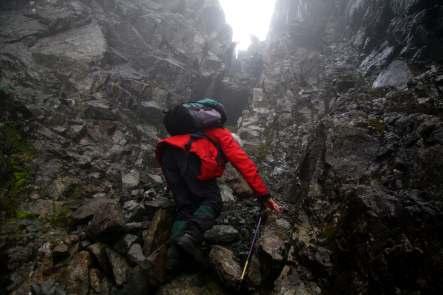
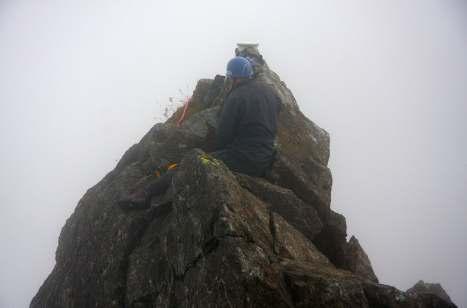
9 The Team The Gully 9

10 Pinnacle 3 from Knight s Peak 10
Survey of Mynydd Anelog
 Survey of Mynydd Anelog 12 July 2013 The Team: John Barnard, Graham Jackson, Myrddyn Phillips, Chris Watson and, Enid and Jeff Parr. 1) Introduction Mynydd Anelog (Hill 1960, Section 30A, OS 1:50000 Map
Survey of Stac Pollaidh
 Survey of Stac Pollaidh 21 August 2018 The Team: John Barnard and Graham Jackson (G&J Surveys), Chris Crocker, Richard Cooper, Michelle Thompson and John Rogerson 1) Introduction G&J Surveys has agreed
Survey of Littleton Down
 Survey of Littleton Down 05 November 2014 The Team: John and Jenny Barnard 1) Introduction Littleton Down (Hill Number 2911, Section 42, OS 1:50000 Map 197, OS 1:25000 Map 121, Grid Ref. SU941150) is listed
Surveys of Creag na Caillich & Carn na Caim South Top
 Surveys of Creag na Caillich & Carn na Caim South Top 29 & 30 July 2015 The Team:- Surveyors John Barnard, Graham Jackson and Myrddyn Phillips Scottish Mountaineering Club (SMC) Rab Anderson and Andy Nisbet
Surveys of Beinn a Chlaidheimh, Beinn Dearg Mor and Ruadh Stac Mor
 Surveys of Beinn a Chlaidheimh, Beinn Dearg Mor and Ruadh Stac Mor 4, 6 & 8 July 2011 The Team:- Surveyors John Barnard, Graham Jackson and Myrddyn Phillips Sponsor and TMS member Alan Haworth TMS Volunteers
Survey of An Dun. 24th March The Team: John Barnard and Graham Jackson.
 Survey of An Dun 24th March 2012 The Team: John Barnard and Graham Jackson. 1) Introduction An Dun (Section 5B, OS 1:50000 Map 42, Grid Ref. NN717805) is a Corbett and a Marilyn. This mountain has two
Survey of Deadwater Fell and Peel Fell
 4 December 2014 Survey of Deadwater Fell and Peel Fell Team: John Barnard, Chris Crocker, Richard Cooper and Graham Jackson 1) Introduction Deadwater Fell (Hill 3542, Section 33, OS 1:50000 Map 80, OS
Below is an example of a well laid-out template of a route card used by the Sionnach Team which is a good format to begin with.
 Route Card A route card is used as a navigational aid to hill walkers by setting out a step by step plan for an intended hike. It is good practice to make out a route card before every hike you or your
Datum Issues in the Red River of the North Basin ----
 Datum Issues in the Red River of the North Basin ---- Scoping Document May 1999 Russell E. Harkness, Hydrologist United States Geological Survey Water Resources Division 2 EXECUTIVE SUMMARY Two datum issues
Navigation Instruction Manual Additional manual to the standard instruction manual
 Release 1.0 for CoMo softwareupdate 1.40 Navigation Instruction Manual Additional manual to the standard instruction manual z WP 5 Takeoff WP 8 x WP 12 landing place y IMPORTANT: Alt2 MUST be setup correctly
TANZANIA CIVIL AVIATION AUTHORITY AIR NAVIGATION SERVICES INSPECTORATE. Title: CONSTRUCTION OF VISUAL AND INSTRUMENT FLIGHT PROCEDURES
 Page 1 of 8 1. PURPOSE 1.1. This Advisory Circular provides guidance to personnel involved in construction of instrument and visual flight procedures for publication in the Aeronautical Information Publication.
The Effects of GPS and Moving Map Displays on Pilot Navigational Awareness While Flying Under VFR
 Wright State University CORE Scholar International Symposium on Aviation Psychology - 7 International Symposium on Aviation Psychology 7 The Effects of GPS and Moving Map Displays on Pilot Navigational
Introduction to Topographic Maps
 Introduction to Topographic Maps DIRECTIONS: Read all of the following content. READ EVERYTHING!! At the end of the packet, you will find two topographic maps. Your task is to indentify each of the elevations
OVERSEAS TERRITORIES AVIATION REQUIREMENTS (OTARs)
") OVERSEAS TERRITORIES AVIATION REQUIREMENTS (OTARs) Part 173 FLIGHT CHECKING ORGANISATION APPROVAL Published by Air Safety Support International Ltd Air Safety Support International Limited 2005 ISBN 0-11790-410-4
OVERSEAS TERRITORIES AVIATION REQUIREMENTS (OTARs) Part 173 FLIGHT CHECKING ORGANISATION APPROVAL Published by Air Safety Support International Ltd Air Safety Support International Limited 2005 ISBN 0-11790-410-4
Flight Inspection for High Elevation Airports
 Flight Inspection for High Elevation Airports Mr. Pan Yi Director Flight Inspection Center of CAAC 23#, Tianzhu Road, Tianzhu Airport Industry Zone, Capital International Airport, Beijing, People s Republic
Pump Fillage Calculation (PFC) Algorithm for Well Control
 Algorithm for Well Control") 6 th Annual Sucker Rod Pumping Workshop Wyndham Hotel, Dallas, Texas September 14 17, 2010 Pump Fillage Calculation (PFC) Algorithm for Well Control Victoria Ehimeakhe, Ph.D. Weatherford Introduction For
6 th Annual Sucker Rod Pumping Workshop Wyndham Hotel, Dallas, Texas September 14 17, 2010 Pump Fillage Calculation (PFC) Algorithm for Well Control Victoria Ehimeakhe, Ph.D. Weatherford Introduction For
Using The Approach Planner
 Using The Approach Planner photo Living With Your Plane For airports and airfields without published procedures (All graphics in this tutorial are for illustration purposes only and not for flying) A Product
Quality Assurance. Introduction Need for quality assurance Answer to the need of quality assurance Details on quality assurance Conclusion A B C D E
 Quality Assurance 1 A B C D E Introduction Need for quality assurance Answer to the need of quality assurance Details on quality assurance Conclusion 2 1 Introduction 3 Introduction The implementation
Active Geodetic Network of Serbia
 Active Geodetic Network of Serbia Oleg ODALOVIC and Ivan ALEKSIC, Serbia Key words: GPS, AGROS, RINEX, RTCM SUMMARY In June 2003 the Republic Geodetic Authority (RGZ) has started the realization of the
CHAPTER 5 SEPARATION METHODS AND MINIMA
 CHAPTER 5 SEPARATION METHODS AND MINIMA 5.1 Provision for the separation of controlled traffic 5.1.1 Vertical or horizontal separation shall be provided: a) between IFR flights in Class D and E airspaces
USING SCOOT MULTI-NODES TO REDUCE PEDESTRIAN DELAY AT DUAL CROSSINGS IN BRISTOL
 USING SCOOT MULTI-NODES TO REDUCE PEDESTRIAN DELAY AT DUAL CROSSINGS IN BRISTOL Jackie Davies, Senior Technical Officer (UTC), Bristol City Council Traffic Signals Synopsis Bristol City Council has received
8 Things Every Aircraft Owner Needs To Know About The 2020 ADS-B Mandate. Contents INTRO: WHAT IS ADS-B EQUIPMENT, AND WHAT DOES IT DO?...
 Contents INTRO:...3 1. WHAT IS ADS-B EQUIPMENT, AND WHAT DOES IT DO?... 4 2. WHY IS THE FAA MANDATING THIS?... 5 3. HOW DOES IT WORK (TECHNICALLY SPEAKING)?... 6 4. HOW MUCH WILL IT COST ME?...7 5. WHEN
Exemplar for Internal Achievement Standard Geography Level 1. Conduct geographic research, with direction
 Exemplar for internal assessment resource Geography for Achievement Standard 91011 Exemplar for Internal Achievement Standard Geography Level 1 This exemplar supports assessment against: Achievement Standard
South East Wales Hang Gliding and Paragliding Club Ltd
 Section Release/Amendment Summary Rev Date All Initial issue 1 12/12/2016 Created By: Reviewed By: Approved By: Martin Cray Committee Member Chris Jones Avon Committee Member Management Representative:
CHAPTER 7 AEROPLANE COMMUNICATION AND NAVIGATION EQUIPMENT
 CHAP 7-1 CHAPTER 7 COMMUNICATION AND NAVIGATION EQUIPMENT 7.1 COMMUNICATION EQUIPMENT 7.1.1 An aeroplane shall be provided with radio communication equipment capable of: a) conducting two-way communication
Self-Guided Walk Langdale Pikes. Start & Finish: NT car park (free to members) at Sticklebarn - on the right just beyond the New Dungeon Ghyll hotel.
 at Sticklebarn - on the right just beyond the New Dungeon Ghyll hotel.") Self-Guided Walk Langdale Pikes Key Information These mountains form a collection of spires and cliffs on the north side of Langdale. This walk visits four of the main tops Pavey Ark, Harrison Stickle,
Self-Guided Walk Langdale Pikes Key Information These mountains form a collection of spires and cliffs on the north side of Langdale. This walk visits four of the main tops Pavey Ark, Harrison Stickle,
A Pilot s perspective
 The Challenges of Modern Approaches, from NPA/PA to 2D/3D operations airborne perspective A Pilot s perspective Stefan Fiedler IFALPA, VC German Cockpit IFALPA Position on PBN (December 2014) IFALPA welcomes
REPORT IN-038/2010 DATA SUMMARY
 REPORT IN-038/2010 DATA SUMMARY LOCATION Date and time Friday, 3 December 2010; 09:46 h UTC 1 Site Sabadell Airport (LELL) (Barcelona) AIRCRAFT Registration Type and model Operator EC-KJN TECNAM P2002-JF
GPS Training
 Garmin Ski Bundles - Garmin with Mountain Dynamics SnowRanger Maps Several years ago Garmin and Mountain Dynamics launched SnowRanger maps for both North America & Europe that included information regarding
PERUVIAN ANDES ADVENTURES. TOCLLARAJU CLIMB or ISHINCA + TOCLLARAJU CLIMBING. Tocllaraju 4 Days Ishinca + Tocllaraju 5 or 6 days
 PERUVIAN ANDES ADVENTURES TOCLLARAJU CLIMB or ISHINCA + TOCLLARAJU CLIMBING Tocllaraju 4 Days Ishinca + Tocllaraju 5 or 6 days PEAKS Tocllaraju: 6034m (19797 ft) Grade: D / Hard / Some steep & technical
Approximate distance: 4.7 miles For this walk we ve included OS grid references should you wish to use them. Start. End
 Approximate distance: 4.7 miles For this walk we ve included OS grid references should you wish to use them. Start End 1 2 3 4 N 5 W E S Reproduced by permission of Ordnance Survey on behalf of HMSO. Crown
Flight Evaluation Schedule For GPS IFR Approval Primary Means Enroute, Terminal and Non-Precision Approach
 Flight Evaluation Schedule For GPS IFR Approval Primary Means Enroute, Terminal and Non-Precision Approach Aircraft Description: Model ZK- Operator GPS Description: Manufacturer Model Serial Number TSO-C129
COMMUTING MASS TRANSPORT CALCULATOR GUIDE Version 1.0
 COMMUTING MASS TRANSPORT CALCULATOR GUIDE Version 1.0 Green Star SA Multi Unit Residential v1 Commuting Mass Transport Calculator Guide First Released: 27 th October 2011 Last Update: 27 th October 2011
HEATHROW COMMUNITY NOISE FORUM
 HEATHROW COMMUNITY NOISE FORUM 3Villages flight path analysis report January 216 1 Contents 1. Executive summary 2. Introduction 3. Evolution of traffic from 25 to 215 4. Easterly departures 5. Westerly
21 November 2016, 18:06 UTC Coordinates --- Altitude Approximately 1700 ft above mean sea level Air traffic service
 Swiss Transportation Safety Investigation Board STSB Summary Report A summary investigation, in accordance with article 45 of the Ordinance on the Safety Investigation of Transport Incidents (OSITI), was
KTRK Flight Tracking System, VNOMS, Altitudes and Positional Calculations
 KTRK Flight Tracking System, VNOMS, Altitudes and Positional Calculations Prepared by: Joseph A. LaMacchia August 17, 2015 Proprietary Information 1 Noise Complaint Details VNOMS Data and Flight Path Flight
Foreword. Loch Ness from the summit of the High Route
 Foreword 4 The Great Glen Way runs for just over 77 miles (125 km) from Fort William to Inverness. It starts beside Britain s highest mountain, Ben Nevis; follows its greatest geological fault along the
LESSON PLAN Introduction (3 minutes)
") LESSON PLAN Introduction (3 minutes) ATTENTION: MOTIVATION: OVERVIEW: Relate aircraft accident in which a multi-engine airplane ran off the end of the runway. This could have been avoided by correctly
LESSON PLAN Introduction (3 minutes) ATTENTION: MOTIVATION: OVERVIEW: Relate aircraft accident in which a multi-engine airplane ran off the end of the runway. This could have been avoided by correctly
Standards and procedures for the approval of performance-based navigation operations. (Presented by Colombia) SUMMARY
 SUMMARY") 216 INTERNATIONAL CIVIL AVIATION ORGANIZATION SAM/IG/9-WP/15 South American Regional Office Regional Project RLA/06/901 12/04/12 Assistance for the implementation of a regional ATM system according to
216 INTERNATIONAL CIVIL AVIATION ORGANIZATION SAM/IG/9-WP/15 South American Regional Office Regional Project RLA/06/901 12/04/12 Assistance for the implementation of a regional ATM system according to
HOW TO IMPROVE HIGH-FREQUENCY BUS SERVICE RELIABILITY THROUGH SCHEDULING
 HOW TO IMPROVE HIGH-FREQUENCY BUS SERVICE RELIABILITY THROUGH SCHEDULING Ms. Grace Fattouche Abstract This paper outlines a scheduling process for improving high-frequency bus service reliability based
MetroAir Virtual Airlines
 MetroAir Virtual Airlines NAVIGATION BASICS V 1.0 NOT FOR REAL WORLD AVIATION GETTING STARTED 2 P a g e Having a good understanding of navigation is critical when you fly online the VATSIM network. ATC
IAGSA Survey Contract Annex
 Notice to Users This document will be expanded and revised from time to time without notice. Users may obtain the most current version from IAGSA s web site at: www.iagsa.ca The Safety Policy Manual referred
Methodology and coverage of the survey. Background
 Methodology and coverage of the survey Background The International Passenger Survey (IPS) is a large multi-purpose survey that collects information from passengers as they enter or leave the United Kingdom.
Cal/Val Activities at the CIGSN Uardry Field Site, NSW, Australia in Support of the EO-1 Mission
 Cal/Val Activities at the CIGSN Uardry Field Site, NSW, Australia in Support of the EO-1 Mission Fred Prata and Graham Rutter CSIRO Atmospheric Research David Jupp CSIRO Earth Observation Centre EOC Annual
Arab Republic of Egypt
 1 Arab Republic of Egypt Ministry of Civil Aviation Egyptian Civil Aviation Authority Duties and responsibilities Procedures 2 The main objective Of Surveying Department is to :- 1. reviewing and accepting
Accident to the Piper PA34-200T Seneca III registered HB-LSD on 7 December 2016 at Basel Mulhouse airport (68)
") INVESTIGATION REPORT www.bea.aero Accident to the Piper PA34-200T Seneca III registered HB-LSD on 7 December 2016 at Basel Mulhouse airport (68) (1) Except where otherwise indicated times in this report
INVESTIGATION REPORT www.bea.aero Accident to the Piper PA34-200T Seneca III registered HB-LSD on 7 December 2016 at Basel Mulhouse airport (68) (1) Except where otherwise indicated times in this report
ASSEMBLY 39TH SESSION
 International Civil Aviation Organization WORKING PAPER A39-WP/118 1 1/8/16 ASSEMBLY 39TH SESSION TECHNICAL COMMISSION Agenda Item 36: Aviation Safety and Air Navigation Implementation Support IMPACT TO
Analysis of en-route vertical flight efficiency
 Analysis of en-route vertical flight efficiency Technical report on the analysis of en-route vertical flight efficiency Edition Number: 00-04 Edition Date: 19/01/2017 Status: Submitted for consultation
ICAO Big Data Project ADS-B Data as a source for analytical solutions for traffic behaviour in airspace
 ICAO Big Data Project ADS-B Data as a source for analytical solutions for traffic behaviour in airspace ICAO/IATA/CANSO PBN/2 San Jose December 8, 2016 Big Data process Quantitative Quantitative / Qualitative
Part 175.D & E Aeronautical Data Originators Data Product Specification: Vertical Obstructions
 Part 175.D & E Aeronautical Data Originators Data Product Specification: Vertical Obstructions ATS-DPS-0010 Version 2 Effective 22 December 2017 Prepared: Authorised: Sateesh Sathineni Aeronautical Data
Looking north from the SW shieling site with Lub na Luachrach in the foreground
 Looking north from the SW shieling site with Lub na Luachrach in the foreground Upper Gleann Goibhre - Shieling sites Two shieling sites in the upper reaches of the Allt Goibhre were visited and recorded
Comparison. Annex 1 to the ICAO Convention JAR-FCL 1
 Comparison to the ICAO Convention JAR-FCL 1 Used Versions :» to the ICAO Convention - up to Amendment 166» JAR-FCL 1 Amendment 3 and NPA-FCL 19 18 May 2005 Comparison to the ICAO Convention JAR-FCL Used
Individual Lab Report Ci-Trol Jun,2016. APTT (seconds) Ci-Trol 1 - Lot# Your Lab
 Ci-Trol 1 - Lot# Your Lab") Individual Lab Report Ci-Trol,2016 ST VINCENT MEDICAL CENTER LABORATORY(LAB# 7300 ) 2131 WEST THIRD STREET LOS ANGELES CA USA 90057 APTT (seconds) SYSMEX CA 1500-1, DADE ACTIN FSL Period SD CV # Points
Individual Lab Report Ci-Trol,2016 ST VINCENT MEDICAL CENTER LABORATORY(LAB# 7300 ) 2131 WEST THIRD STREET LOS ANGELES CA USA 90057 APTT (seconds) SYSMEX CA 1500-1, DADE ACTIN FSL Period SD CV # Points
USE OF RADAR IN THE APPROACH CONTROL SERVICE
 USE OF RADAR IN THE APPROACH CONTROL SERVICE 1. Introduction The indications presented on the ATS surveillance system named radar may be used to perform the aerodrome, approach and en-route control service:
Aircraft Systems and 4D Trajectory Management
 Aircraft Systems and 4D Trajectory Management September 2012 David De Smedt EUROCONTROL 1 i4d concept (SESAR) Share and synchronise airborne and ground trajectory Flying to time constraints to optimize
CFIT-Procedure Design Considerations. Use of VNAV on Conventional. Non-Precision Approach Procedures
 OCP-WG-WP 4.18 OBSTACLE CLEARANCE PANEL WORKING GROUP AS A WHOLE MEETING ST. PETERSBURG, RUSSIA 10-20 SEPTEMBER 1996 Agenda Item 4: PANS-OPS Implementation CFIT-Procedure Design Considerations Use of VNAV
ONE PLATFORM, MULTIPLE APPLICATIONS: SURVEYING CONSTRUCTION FORESTRY AGRICULTURE ENVIRONMENT POWER ENGINEERING BIRDIE YOUR TAILOR-MADE UAV
 UAV BIRDIE BIRDIE YOUR TAILOR-MADE UAV ONE PLATFORM, MULTIPLE APPLICATIONS: SURVEYING CONSTRUCTION FORESTRY AGRICULTURE ENVIRONMENT POWER ENGINEERING BIRDIE UAV is the complete mapping solution, made for
TWELFTH AIR NAVIGATION CONFERENCE
 International Civil Aviation Organization AN-Conf/12-WP/6 7/5/12 WORKING PAPER TWELFTH AIR NAVIGATION CONFERENCE Agenda Item 2: Aerodrome operations improving airport performance 2.2: Performance-based
USING ENGINEERING SURVEY TECHNIQUES FOR THE TONKOLILI RAILWAYS PROJECT. Prof. Maricel PALAMARIU, Ph.D. Eng. Lect. Mircea PUȘCAȘ, Eng.
 USING ENGINEERING SURVEY TECHNIQUES FOR THE TONKOLILI RAILWAYS PROJECT Prof. Maricel PALAMARIU, Ph.D. Eng. Lect. Mircea PUȘCAȘ, Eng. Marrakech, Morocco, 18-22 May 2011 Contents 1. Introduction 2. Phase
Navigation Systems. 1. The Chart Supplement provides a listing of available VOR receiver ground checkpoints and VOTs (VOR receiver test facilities).
.") Navigation Systems 3.1 DISTANCE MEASURING EQUIPMENT (DME) 1. DME displays slant range distance in nautical miles. 2. Ignore slant range error if the airplane is 1 NM or more from the ground facility for
Navigation Systems 3.1 DISTANCE MEASURING EQUIPMENT (DME) 1. DME displays slant range distance in nautical miles. 2. Ignore slant range error if the airplane is 1 NM or more from the ground facility for
Front Line Managers (FLMs) and Airline Pilots Training for Operational Evaluation! of enhanced Final Approach Runway Occupancy Signal (efaros) at DFW!
 and Airline Pilots Training for Operational Evaluation! of enhanced Final Approach Runway Occupancy Signal (efaros) at DFW!") ! Front Line Managers (FLMs) and Airline Pilots Training for Operational Evaluation! of enhanced Final Approach Runway Occupancy Signal (efaros) at DFW! Maria Picardi Kuffner! September 2008, updated July
! Front Line Managers (FLMs) and Airline Pilots Training for Operational Evaluation! of enhanced Final Approach Runway Occupancy Signal (efaros) at DFW! Maria Picardi Kuffner! September 2008, updated July
Flight Data Monitoring Conference 2009
 Flight Data Monitoring Conference 2009 Avidyne Investment in Data Recording Avidyne has been investing in data recording capabilities on the over 5000 PFD and MFD products for over eight years. The capability
Operators may need to retrofit their airplanes to ensure existing fleets are properly equipped for RNP operations. aero quarterly qtr_04 11
 Operators may need to retrofit their airplanes to ensure existing fleets are properly equipped for RNP operations. 24 equipping a Fleet for required Navigation Performance required navigation performance
ERASMUS. Strategic deconfliction to benefit SESAR. Rosa Weber & Fabrice Drogoul
 ERASMUS Strategic deconfliction to benefit SESAR Rosa Weber & Fabrice Drogoul Concept presentation ERASMUS: En Route Air Traffic Soft Management Ultimate System TP in Strategic deconfliction Future 4D
1973 Cessna Skymaster 337 Instrumentation
 1973 Cessna Skymaster 337 Instrumentation The Cessna Skymaster 337 is a centerline thrust twin engine aircraft. In my research it seemed that no two had the same instrumentation. The aircraft instrumentation
The Importance of Flight Dispatching in Air Transportation
 Journal of Air Law and Commerce Volume 9 1938 The Importance of Flight Dispatching in Air Transportation Larry C. Fritz Follow this and additional works at: https://scholar.smu.edu/jalc Recommended Citation
HB/VS-078 Üssers Barrhorn
 HB/VS-078 Üssers Barrhorn Paul HB9DST, August 23, 2015 Summary: This was a HB9SOTA club project, an activation of the highest summit in Europe you can hike up without ropes or other equipment. The headline
VINSON MASSIF EXPEDITIONS 2017/2018 TRIP NOTES
 VINSON MASSIF EXPEDITIONS 2017/2018 TRIP NOTES VINSON MASSIF 2017/2018 Expedition Notes All material Copyright Adventure Consultants Ltd 2017/2018 During the southern summer of 2017/2018, Adventure Consultants
Learning Objectives 7.3 Flight Performance and Planning Flight Planning & Flight Monitoring
 030 00 00 00 FLIGHT PERFORMANCE AND PLANNING 033 00 00 00 FLIGHT PLANNING AND FLIGHT MONITORING 033 01 00 00 FLIGHT PLANNING FOR VFR FLIGHTS Remark Using Training Route Manual VFR charts or CQB Annexes
The Rodman s Guide to Madison Vertical Datums
 The Rodman s Guide to Madison Vertical Datums by Dan Rodman, Wisconsin Professional Land Surveyor No. 2793 City of Madison, WI Parks Division E-mail: drodman@cityofmadison.com Tel: (608)266-6674 Version:
Kristina Ricks ISYS 520 VBA Project Write-up Around the World
 VBA Project Write-up Around the World Initial Problem Online resources are very valuable when searching for the cheapest flights to any particular location. Sites such as Travelocity.com, Expedia.com,
LAUNCHING YOUR UNMANNED AIRCRAFT PROGRAM
 LAUNCHING YOUR UNMANNED AIRCRAFT PROGRAM THE DARTDRONES TEAM UNMANNED AIRCRAFT APPLICATIONS AERIAL INSPECTIONS AERIAL INSPECTIONS Safer and faster alternative to visual inspection by an individual Damage
SRTA Year End Fixed Route Ridership Analysis: FY 2018
 SRTA Year End Fixed Route Ridership Analysis: FY 2018 2018 Contents Introduction... 1 A. Key Terms Used in this Report... 1 Key Findings... 2 A. Ridership... 2 B. Fare Payment... 4 Performance Analysis
CONGESTION MONITORING THE NEW ZEALAND EXPERIENCE. By Mike Curran, Manager Strategic Policy, Transit New Zealand
 CONGESTION MONITORING THE NEW ZEALAND EXPERIENCE 26 th Australasian Transport Research Forum Wellington New Zealand 1-3 October 2003 By, Manager Strategic Policy, Transit New Zealand Abstract New Zealand
Predicting Flight Delays Using Data Mining Techniques
 Todd Keech CSC 600 Project Report Background Predicting Flight Delays Using Data Mining Techniques According to the FAA, air carriers operating in the US in 2012 carried 837.2 million passengers and the
Dixon Trail Construction - From the Top of the Mountain 2016 Interim Report Friends of Cheyenne Mountain State Park September 2 nd, 2016
 - Dixon Trail Construction - From the Top of the Mountain 2016 Interim Report Friends of Cheyenne Mountain State Park September 2 nd, 2016 Prepared by: Andy Riter, Program Coordinator, and Joe Lavorini,
The Cleo s Bath North Side Hike
 The Cleo s Bath North Side Hike This hike is a cross-country hike from Pinecrest Lake to the north side of Cleo s Bath. It is quieter and much less crowded than the normal route, which goes up the south
COSTA BLANCA MOUNTAIN WALKERS - WALK DESCRIPTION. Visit for more walks descriptions in Spain
 COSTA BLANCA MOUNTAIN WALKERS - WALK DESCRIPTION Visit www.walksinspain.org for more walks descriptions in Spain Walk description originally prepared by:- Ralph Phipps Last Updated 25th Sep 2015 Title
FLIGHT LESSON RECORD
 FLIGHT LESSON RECORD LESSON 1: INTRODUCTION TO FLIGHT FM41-45 FM45-49 FM81 FM 78-82 FM86-89 FM90-94 FM 95-98 FM 110-117 PH 36-39 PH176-179 FM118-134 FM284 New Lesson Items Certificates and documents Airplane
Helicopter Performance. Performance Class 1. Jim Lyons
 Helicopter Performance Performance Class 1 Jim Lyons What is Performance Class 1 Content of Presentation Elements of a Category A Take-off Procedure (CS/FAR 29) PC1 Take-off Requirements PC1
PERUVIAN ANDES ADVENTURES. ARTESONRAJU CLIMB 6025m (19767 ft) Grade: D+ to TD/ Technical. Routes: The two routes to climb Artesonraju are;
 Grade: D+ to TD/ Technical. Routes: The two routes to climb Artesonraju are;") PERUVIAN ANDES ADVENTURES ARTESONRAJU CLIMB 6025m (19767 ft) Grade: D+ to TD/ Technical Routes: The two routes to climb Artesonraju are; *Via the Paron Valley South East Ridge 5 days (option for 6 with
PERUVIAN ANDES ADVENTURES ARTESONRAJU CLIMB 6025m (19767 ft) Grade: D+ to TD/ Technical Routes: The two routes to climb Artesonraju are; *Via the Paron Valley South East Ridge 5 days (option for 6 with
AERONAUTICAL INFORMATION DIGITAL DATBASES INTERGATION AND QUALITY MANAGED MIGRATION
 AIM SG/5 (Egypt, Cairo, 22 24 January 2019) AERONAUTICAL INFORMATION DIGITAL DATBASES INTERGATION AND QUALITY MANAGED MIGRATION Presentation contents : 1. NG Aviation company overview 2. New documentation
Potential of CO 2 retrieval from IASI
 Potential of CO 2 retrieval from IASI L. Chaumat, O. Lezeaux, P. Prunet, B. Tournier F.-R. Cayla (SISCLE), C. Camy-Peyret (LPMAA) and T. Phulpin (CNES) Study supported by CNES ITSC-XVI: Angra dos Reis,
JAA Administrative & Guidance Material Section Five: Licensing, Part Two: Procedures
 INTRODUCTION Preliminary general remark: 1 To fully appreciate and understand subject 033, the applicant will benefit from background knowledge in subjects 010, 020, 031, 032/034, 050, 060, 070 and 080.
DELIBERATE RISK ASSESSMENT WORKSHEET
 1. ISSION/TASK DESCRIPTION (INCUDE DATES OF EVENT) 2. DATE (DD//YYYY) DJI atrice100 Video Platform, Camp Roberts testing, arth 20-24, 2018 02/14/2018 3. PREPARED BY a. Name (ast, First, iddle Initial)
New generation aircraft in the instrument approach domain. Jean-Christophe Lair Airbus Test pilot 1 st Feb. 2017
 New generation aircraft in the instrument approach domain Jean-Christophe Lair Airbus Test pilot 1 st Feb. 2017 Agenda Video A little bit of history Today s situation A350 XWB solutions for final approaches
VOLUME 4 AIRCRAFT EQUIPMENT AND OPERATIONAL AUTHORIZATION CHAPTER 1 AIR NAVIGATION, COMMUNICATIONS, AND SURVEILLANCE. Section 4 Class II Navigation
 VOLUME 4 AIRCRAFT EQUIPMENT AND OPERATIONAL AUTHORIZATION CHAPTER 1 AIR NAVIGATION, COMMUNICATIONS, AND SURVEILLANCE 4-76 GENERAL. Section 4 Class II Navigation A. Concepts, Direction, and Guidance. This
The Swansea Canal & St Catherine s Church at Pontardawe
 INSPIRING LANDSCAPES FASCINATING HISTORY & LEGEND GREAT WALKS IN THE SWANSEA VALLEY Clydach to Pontardawe along the Swansea Canal, at Pontardawe the railway that never was! Historic & Geographic Background
Challenges in Complex Procedure Design Validation
 Challenges in Complex Procedure Design Validation Frank Musmann, Aerodata AG ICAO Workshop Seminar Aug. 2016 Aerodata AG 1 Procedure Validation Any new or modified Instrument Flight Procedure is required
EXPERIMENTAL ANALYSIS OF THE INTEGRATION OF MIXED SURVEILLANCE FREQUENCY INTO OCEANIC ATC OPERATIONS
 EXPERIMENTAL ANALYSIS OF THE INTEGRATION OF MIXED SURVEILLANCE FREQUENCY INTO OCEANIC ATC OPERATIONS Laura Major Forest & R. John Hansman C.S. Draper Laboratory, Cambridge, MA 9 USA; lforest@draper.com
Policy Letter (PL) Global Positioning System (GPS) Equipment and Installation Approval
 Global Positioning System (GPS) Equipment and Installation Approval") Policy Letter (PL) Global Positioning System (GPS) Equipment and Installation Approval File No. 5009-32-0 PL No. 551-003 RDIMS No. 1019349-V5 Issue No. 01 Issuing Branch Aircraft Certification Effective
Policy Letter (PL) Global Positioning System (GPS) Equipment and Installation Approval File No. 5009-32-0 PL No. 551-003 RDIMS No. 1019349-V5 Issue No. 01 Issuing Branch Aircraft Certification Effective
Air Navigation Bureau ICAO Headquarters, Montreal
 Performance Based Navigation Introduction to PBN Air Navigation Bureau ICAO Headquarters, Montreal 1 Performance Based Navigation Aviation Challenges Navigation in Context Transition to PBN Implementation
Hillwalking. Hillwalking Adventure Skill
 Hillwalking Hillwalking Adventure Skill External qualification BOS - the Irish Mountain Training Board in the South and MLTNI in Northern Ireland run a number of Mountain Leadership courses. Those who
Brighton City Airport Brighton City Airport, Shoreham by Sea, BN43 5FF
 Site: «JobCustom Site Address» Test date: «JobCustom PCT Test Date» Field measurements of sound insulation ANC Registration No: 117 REPORT No: «JobCustom ANC No.» Acoustic Associates Sussex Ltd Client:
MODEL AERONAUTICAL ASSOCIATION OF AUSTRALIA
 MODEL AERONAUTICAL ASSOCIATION OF AUSTRALIA FIRST PERSON VIEW (FPV) AND SELF GUIDED MODEL AIRCRAFT POLICY MOP066 PPROVED: MAAA PRESIDENT Date: 10/08/2016 Amendments made to MOP066 Paragraph Brief description
Feasibility and Benefits of a Cockpit Traffic Display-Based Separation Procedure for Single Runway Arrivals and Departures
 Feasibility and Benefits of a Cockpit Traffic Display-Based Separation Procedure for Single Runway Arrivals and Departures Implications of a Pilot Survey and Laboratory Simulations Dr. Anand M. Mundra
Technical aspects of OBU tolling
 Technical aspects of OBU tolling Version date: 1 May 2017 Table of Contents 1) How does the OBU calculate the toll?... 3 GPS Positioning and Map Matching... 3 How does the OBU calculate the toll?... 4
10%discount for bookings before May 1 st
 MOUNTAINEERING IRELAND SUMMER ALPINE MEET 2017 LA BERARDE, OISANS, FRANCE 10%discount for bookings before May 1 st Location for the meet The 2017 Mountaineering Ireland Summer Meet will take place in La
a. Aeronautical charts DID THIS IN LESSON 2
 AIRMAN CERTIFICATION STANDARDS: REMOTE PILOT SMALL: You will know and be able to explain in writing or oral form the below tasks regarding AIRPORT OPERATIONS Task References Objective Task B. Airport Operations
Barton on Sea. Owned by: New Forest District Council Wind Direction SW SE (135 to 225 ) Best: S (180 )
 Best: S (180 )") OS Grid Ref: SZ 242 929 (Map 195) GPS: N50:44.113 W1:39.507 Owned by: New Forest District Council Wind Direction SW SE (135 to 225 ) Best: S (180 ) Nearest Phone: Casualty Units: Junction of Marine drive
OS Grid Ref: SZ 242 929 (Map 195) GPS: N50:44.113 W1:39.507 Owned by: New Forest District Council Wind Direction SW SE (135 to 225 ) Best: S (180 ) Nearest Phone: Casualty Units: Junction of Marine drive